Quantitative maps of groundwater resources in Africa... · Quantitative maps of groundwater...
8
Quantitative maps of groundwater resources in Africa This article has been downloaded from IOPscience. Please scroll down to see the full text article. 2012 Environ. Res. Lett. 7 024009 (http://iopscience.iop.org/1748-9326/7/2/024009) Download details: IP Address: 173.10.136.30 The article was downloaded on 20/04/2012 at 18:57 Please note that terms and conditions apply. View the table of contents for this issue, or go to the journal homepage for more Home Search Collections Journals About Contact us My IOPscience
Transcript of Quantitative maps of groundwater resources in Africa... · Quantitative maps of groundwater...
Quantitative maps of groundwater resources in Africa
This article has been downloaded from IOPscience. Please scroll down to see the full text article.
2012 Environ. Res. Lett. 7 024009
(http://iopscience.iop.org/1748-9326/7/2/024009)
Download details:
IP Address: 173.10.136.30
The article was downloaded on 20/04/2012 at 18:57
Please note that terms and conditions apply.
View the table of contents for this issue, or go to the journal homepage for more
Home Search Collections Journals About Contact us My IOPscience
IOP PUBLISHING ENVIRONMENTAL RESEARCH LETTERS
Environ. Res. Lett. 7 (2012) 024009 (7pp) doi:10.1088/1748-9326/7/2/024009
Quantitative maps of groundwaterresources in AfricaA M MacDonald1, H C Bonsor1, B E O Dochartaigh1 and R G Taylor2
1 British Geological Survey, West Mains Road, Edinburgh EH9 3LA, UK2 Department of Geography, University College London, Gower Street, London WC1E 6BT, UK
E-mail: [email protected]
Received 7 February 2012Accepted for publication 19 March 2012Published 19 April 2012Online at stacks.iop.org/ERL/7/024009
AbstractIn Africa, groundwater is the major source of drinking water and its use for irrigation isforecast to increase substantially to combat growing food insecurity. Despite this, there is littlequantitative information on groundwater resources in Africa, and groundwater storage isconsequently omitted from assessments of freshwater availability. Here we present the firstquantitative continent-wide maps of aquifer storage and potential borehole yields in Africabased on an extensive review of available maps, publications and data. We estimate totalgroundwater storage in Africa to be 0.66 million km3 (0.36–1.75 million km3). Not all of thisgroundwater storage is available for abstraction, but the estimated volume is more than 100times estimates of annual renewable freshwater resources on Africa. Groundwater resourcesare unevenly distributed: the largest groundwater volumes are found in the large sedimentaryaquifers in the North African countries Libya, Algeria, Egypt and Sudan. Nevertheless, formany African countries appropriately sited and constructed boreholes can support handpumpabstraction (yields of 0.1–0.3 l s−1), and contain sufficient storage to sustain abstractionthrough inter-annual variations in recharge. The maps show further that the potential forhigher yielding boreholes (>5 l s−1) is much more limited. Therefore, strategies for increasingirrigation or supplying water to rapidly urbanizing cities that are predicated on the widespreaddrilling of high yielding boreholes are likely to be unsuccessful. As groundwater is the largestand most widely distributed store of freshwater in Africa, the quantitative maps are intended tolead to more realistic assessments of water security and water stress, and to promote a morequantitative approach to mapping of groundwater resources at national and regional level.
Keywords: groundwater, Africa, climate change, water resources
S Online supplementary data available from stacks.iop.org/ERL/7/024009/mmedia
1. Introduction
Water use in Africa is set to increase markedly over the nextfew decades as a result of population growth and plannedincreases in irrigation (Vorosmarty et al 2005). Currently,there are more than 300 million people in Africa withoutaccess to safe drinking water (JMP 2010), many of whomare amongst the poorest and most vulnerable in the world(Hunter et al 2010). Consequently, increasing access toimproved water supplies is an international priority (Bartramand Cairncross 2010). Even for those with access to improved
water sources, there is growing evidence that domestic wateruse will need to increase substantially to help move people outof poverty (Grey and Sadoff 2007, Hunter et al 2010). Thereare also concerns about per capita food production in Africa(Funk and Brown 2009) that are likely to be exacerbatedby climate change. Currently only 5% of the arable land isirrigated (Siebert et al 2010) and there is much discussionabout increasing irrigation to help meet rising demands forfood production in the context of less reliable rainfall (UNEP2010, Pfister et al 2011).
11748-9326/12/024009+07$33.00 c© 2012 IOP Publishing Ltd Printed in the UK
Environ. Res. Lett. 7 (2012) 024009 A M MacDonald et al
Increasing reliable water supplies throughout Africawill depend on the development of groundwater (Giordano2009, MacDonald and Calow 2009). Groundwater respondsmuch more slowly to meteorological conditions than surfacewater and, as such, provides a natural buffer against climatevariability, including drought (Calow et al 1997, 2010).Groundwater generally does not require treatment since it isnaturally protected from pathogenic contamination, althoughin some environments elevated iron, fluoride or arsenicconcentrations can be a problem (Smedley 1996, Edmundsand Smedley 2005). Groundwater can also be found in mostenvironments using the appropriate exploration techniquesso supplies can be located close to the point of need,minimizing the requirement for extensive reticulation systems(MacDonald and Calow 2009).
Groundwater, however, is neither a universal panaceato water problems nor invulnerable to degradation. Carefulcharacterization of the resource is required to guideinvestments in water supply and to manage the resourceto minimize environmental degradation (Foster and Chilton2003) and widespread depletion. Limited knowledge ofAfrican groundwater resources is evident from the paucityof information on groundwater included in the IPCC FourthAssessment Report and Technical Paper on water (Bateset al 2008) which noted major uncertainty in how changesin climate may affect groundwater and what resources arecurrently available to help support adaptation strategies.
Quantitative, spatially explicit information on ground-water in Africa is required to characterize this resource inways that can usefully inform strategies to adapt to growingwater demand associated not only with population growth butalso climate variability and change. Current continent-widegroundwater maps provide only qualitative information onthe likely extent of aquifers (Struckmeier and Richts 2008,Seguin 2008, MacDonald and Calow 2009). As such, keyquantitative information outlining the dimensions of thecontinent’s groundwater resources have, to date, remainedunresolved. We address this significant knowledge gap bydeveloping the first quantitative maps of groundwater storageand potential groundwater yields in Africa.
2. Methods
Groundwater occurrence depends primarily on geology, ge-omorphology/weathering and effective rainfall (both currentand historic). The interplay of these three factors gives riseto complex hydrogeological environments with innumerablevariations in aquifer transmissivity (the permeability of therocks integrated over thickness); effective porosity (the totalporosity minus the volume taken up by water bound to claysor more rarely held in isolated unconnected pore spaces),saturated thickness of aquifers; and groundwater recharge.Direct measurements of transmissivity and effective porosityare scarce for much of Africa (Adelana and MacDonald2008). Instead we use proxies for these parameters whichhave been found to be effective surrogates in data limitedareas. For transmissivity, we use reported borehole yields(termed aquifer productivity). Although borehole yields are
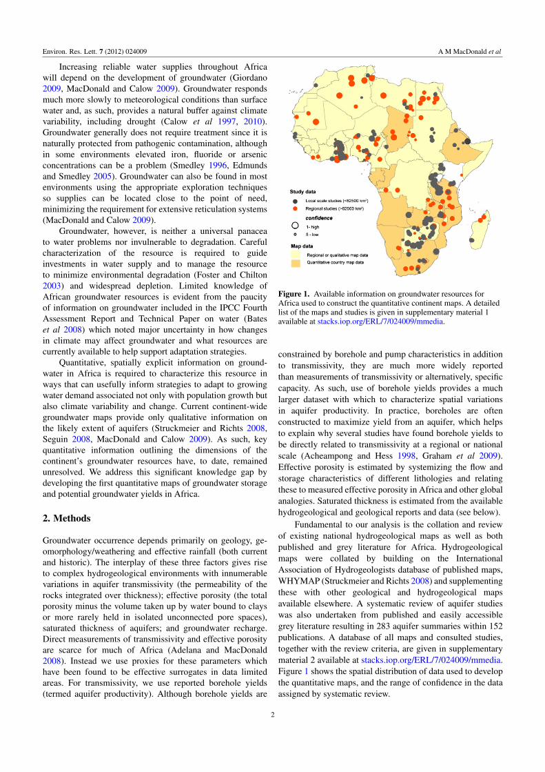
Figure 1. Available information on groundwater resources forAfrica used to construct the quantitative continent maps. A detailedlist of the maps and studies is given in supplementary material 1available at stacks.iop.org/ERL/7/024009/mmedia.
constrained by borehole and pump characteristics in additionto transmissivity, they are much more widely reportedthan measurements of transmissivity or alternatively, specificcapacity. As such, use of borehole yields provides a muchlarger dataset with which to characterize spatial variationsin aquifer productivity. In practice, boreholes are oftenconstructed to maximize yield from an aquifer, which helpsto explain why several studies have found borehole yields tobe directly related to transmissivity at a regional or nationalscale (Acheampong and Hess 1998, Graham et al 2009).Effective porosity is estimated by systemizing the flow andstorage characteristics of different lithologies and relatingthese to measured effective porosity in Africa and other globalanalogies. Saturated thickness is estimated from the availablehydrogeological and geological reports and data (see below).
Fundamental to our analysis is the collation and reviewof existing national hydrogeological maps as well as bothpublished and grey literature for Africa. Hydrogeologicalmaps were collated by building on the InternationalAssociation of Hydrogeologists database of published maps,WHYMAP (Struckmeier and Richts 2008) and supplementingthese with other geological and hydrogeological mapsavailable elsewhere. A systematic review of aquifer studieswas also undertaken from published and easily accessiblegrey literature resulting in 283 aquifer summaries within 152publications. A database of all maps and consulted studies,together with the review criteria, are given in supplementarymaterial 2 available at stacks.iop.org/ERL/7/024009/mmedia.Figure 1 shows the spatial distribution of data used to developthe quantitative maps, and the range of confidence in the dataassigned by systematic review.
2
Environ. Res. Lett. 7 (2012) 024009 A M MacDonald et al
The new quantitative maps of groundwater in Africawere developed in the following manner: (1) the digital1:5 million scale geological map of Africa (Persitset al 1997) was modified by dividing Precambrian rocksinto hydrogeologically significant units (meta-sedimentary,mobile-belt, craton), and classifying sedimentary rocksaccording to the major basins to which they belong;(2) published national and regional hydrogeological mapswere georeferenced and used to further combine or dividegeological units; (3) the modified geological basemap wasparameterized using available quantitative information fromthe national hydrogeological maps and the georeferencedaquifer studies for aquifer productivity (the approximateinterquartile range in the yield of appropriately sitedboreholes); saturated aquifer thickness (the estimated rangein total saturated thickness for the aquifer units) andaquifer flow/storage type (classified as fractured volcanicrocks, weathered and non-weathered crystalline basement,dominantly fractured, mixed intergranular/fractured anddominantly intergranular consolidated sedimentary rocks, andunconsolidated sediments); and (4) peer review of the draftquantitative maps by 12 regional experts.
To estimate groundwater storage the saturated aquiferthickness was multiplied by effective porosity (φe). Foreach of the aquifer flow/storage types an effective porosity(φe) range was assigned based on a series of studiesacross Africa and surrogates in other parts of the world.Weathered basement and fractured volcanic rocks wereassigned a mean φe of 5% (1–10%), which is representativeof moderately decomposed crystalline basement (Taylor andEggleton 2001, Petford 2003, Howard and Griffith 2009).Fractured sedimentary rocks were assigned a mean φe of 8%(3–15%) based on studies in the Karoo basin (Van der Voort2001); the Voltaian Sediments (Pelig-Ba 2009), and the BenueTrough (Lott 1998). Mixed intergranular and fractured rockswere assigned a mean φe of 15% (10–30%) based on a studiesin Nigeria (Samaila and Singh 2010), Botswana (Jones 2010),surrogates in the UK (Allen et al 1997) and global oil industrystudies of porosity in cemented siliciclastic reservoirs (Morse1994). Intergranular aquifers were assigned a mean φe of 25%(20–35%), a conservative value based on the studies in theContinental Terminale (Adelana and MacDonald 2008), theChad Basin (Nwankwo et al 2009) and the Nubian Sandstone(Beavan et al 1991).
Figure 1 shows the distribution of data used to developthe continental maps. Good quality hydrogeological maps andstudies are available for much of southern Africa, but there isa lack of quantitative national hydrogeological maps in north,west and central Africa. In western Africa, this is compensatedby the availability of many individual smaller studies, mostnotably in Nigeria and Ghana. In northern Africa, the sizeof individual studies tend to be much larger and involvecharacterizing major regional aquifers that substitute for thelack of high quality national maps. In central Africa both mapsand literature are scarce.
3. Results and discussion
3.1. Groundwater storage
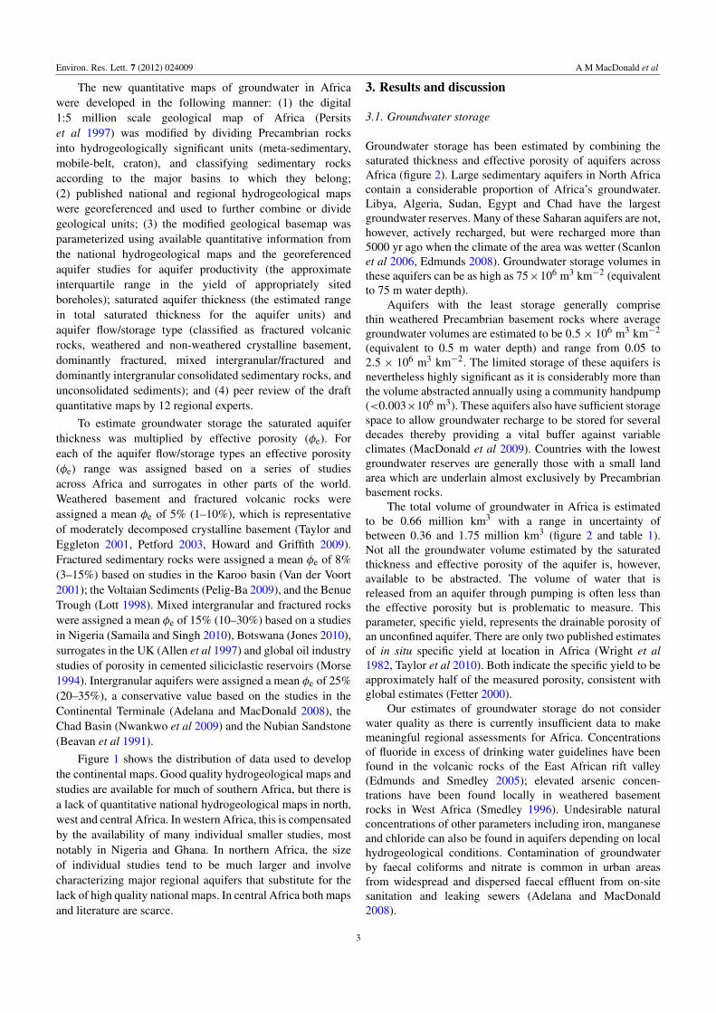
Groundwater storage has been estimated by combining thesaturated thickness and effective porosity of aquifers acrossAfrica (figure 2). Large sedimentary aquifers in North Africacontain a considerable proportion of Africa’s groundwater.Libya, Algeria, Sudan, Egypt and Chad have the largestgroundwater reserves. Many of these Saharan aquifers are not,however, actively recharged, but were recharged more than5000 yr ago when the climate of the area was wetter (Scanlonet al 2006, Edmunds 2008). Groundwater storage volumes inthese aquifers can be as high as 75×106 m3 km−2 (equivalentto 75 m water depth).
Aquifers with the least storage generally comprisethin weathered Precambrian basement rocks where averagegroundwater volumes are estimated to be 0.5× 10⁶ m3 km−2
(equivalent to 0.5 m water depth) and range from 0.05 to2.5 × 106 m3 km−2. The limited storage of these aquifers isnevertheless highly significant as it is considerably more thanthe volume abstracted annually using a community handpump(<0.003×10⁶ m3). These aquifers also have sufficient storagespace to allow groundwater recharge to be stored for severaldecades thereby providing a vital buffer against variableclimates (MacDonald et al 2009). Countries with the lowestgroundwater reserves are generally those with a small landarea which are underlain almost exclusively by Precambrianbasement rocks.
The total volume of groundwater in Africa is estimatedto be 0.66 million km3 with a range in uncertainty ofbetween 0.36 and 1.75 million km3 (figure 2 and table 1).Not all the groundwater volume estimated by the saturatedthickness and effective porosity of the aquifer is, however,available to be abstracted. The volume of water that isreleased from an aquifer through pumping is often less thanthe effective porosity but is problematic to measure. Thisparameter, specific yield, represents the drainable porosity ofan unconfined aquifer. There are only two published estimatesof in situ specific yield at location in Africa (Wright et al1982, Taylor et al 2010). Both indicate the specific yield to beapproximately half of the measured porosity, consistent withglobal estimates (Fetter 2000).
Our estimates of groundwater storage do not considerwater quality as there is currently insufficient data to makemeaningful regional assessments for Africa. Concentrationsof fluoride in excess of drinking water guidelines have beenfound in the volcanic rocks of the East African rift valley(Edmunds and Smedley 2005); elevated arsenic concen-trations have been found locally in weathered basementrocks in West Africa (Smedley 1996). Undesirable naturalconcentrations of other parameters including iron, manganeseand chloride can also be found in aquifers depending on localhydrogeological conditions. Contamination of groundwaterby faecal coliforms and nitrate is common in urban areasfrom widespread and dispersed faecal effluent from on-sitesanitation and leaking sewers (Adelana and MacDonald2008).
3
Environ. Res. Lett. 7 (2012) 024009 A M MacDonald et al
a) b( ( )
Figure 2. Groundwater storage for Africa based on the effective porosity and saturated aquifer thickness. Panel (a) shows a map ofgroundwater storage expressed as water depth in millimetres with modern annual recharge for comparison (Doll and Fiedler 2008).Panel (b) shows the volume of groundwater storage for each country; the error bars are calculated by recalculating storage using the fullranges of effective porosity and thickness for each aquifer, rather than the best estimate. Annual renewable freshwater availability (FAO2005) generally used in water scarcity assessments is shown for comparison.
Notwithstanding the uncertainties discussed above, theestimated groundwater storage (0.66 million km3) representsa water resource that is of a different magnitude to allother freshwater sources in Africa. Annual average rainfallis approximately 0.02 million km3 (New et al 2000) andfreshwater storage in lakes is estimated to be 0.03 million km3
(Shiklomanov and Rodda 2003). Water scarcity assessments(e.g. Falkenmark 1989, Vorosmarty et al 2010) are basedon renewable freshwater resources defined by river dischargeand estimated groundwater recharge which amount toapproximately 0.004 million km3 (FAO 2005, UNEP 2010).Figure 2 illustrates that many countries designated as ‘waterscarce’ have substantial groundwater reserves. These largereserves provide a large and important buffer to changes inclimate, and are therefore integral to the development ofadaptation strategies to current and future climatic variability.
3.2. Aquifer productivity
The accessibility of the groundwater resources is as importantas overall groundwater storage in determining how fargroundwater can support nations and communities to adaptto climate change and population growth (Calow et al 2010).Groundwater is accessed and abstracted, generally throughdrilling boreholes, and the yield of the borehole will limit therate at which groundwater can be abstracted. For a communitywater supply fitted with a handpump, a borehole must be able
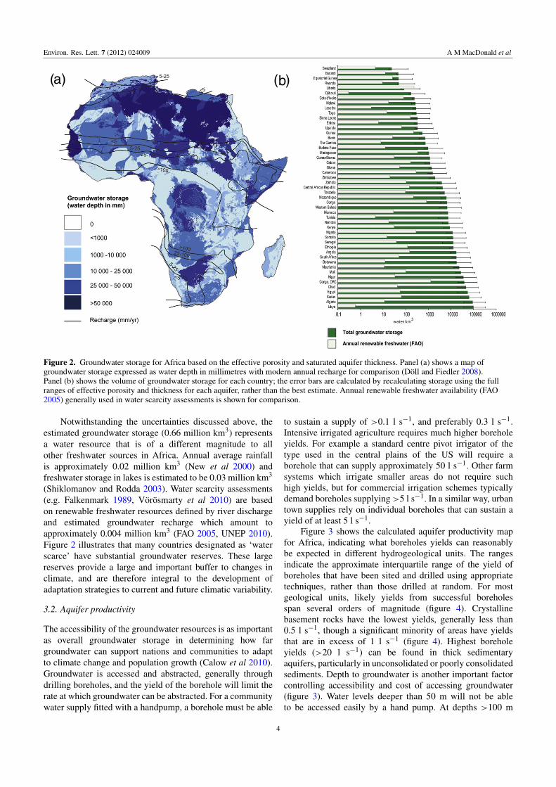
to sustain a supply of >0.1 l s−1, and preferably 0.3 l s−1.Intensive irrigated agriculture requires much higher boreholeyields. For example a standard centre pivot irrigator of thetype used in the central plains of the US will require aborehole that can supply approximately 50 l s−1. Other farmsystems which irrigate smaller areas do not require suchhigh yields, but for commercial irrigation schemes typicallydemand boreholes supplying>5 l s−1. In a similar way, urbantown supplies rely on individual boreholes that can sustain ayield of at least 5 l s−1.
Figure 3 shows the calculated aquifer productivity mapfor Africa, indicating what boreholes yields can reasonablybe expected in different hydrogeological units. The rangesindicate the approximate interquartile range of the yield ofboreholes that have been sited and drilled using appropriatetechniques, rather than those drilled at random. For mostgeological units, likely yields from successful boreholesspan several orders of magnitude (figure 4). Crystallinebasement rocks have the lowest yields, generally less than0.5 l s−1, though a significant minority of areas have yieldsthat are in excess of 1 l s−1 (figure 4). Highest boreholeyields (>20 l s−1) can be found in thick sedimentaryaquifers, particularly in unconsolidated or poorly consolidatedsediments. Depth to groundwater is another important factorcontrolling accessibility and cost of accessing groundwater(figure 3). Water levels deeper than 50 m will not be ableto be accessed easily by a hand pump. At depths >100 m
4
Environ. Res. Lett. 7 (2012) 024009 A M MacDonald et al
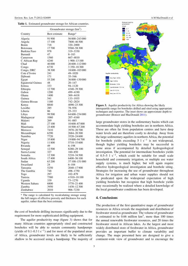
Table 1. Estimated groundwater storage for African countries.
Country
Groundwater storage (km3)
Best estimate Rangea
Algeria 91 900 56 000–243 000Angola 17 100 7800–46 500Benin 718 320–2000Botswana 17 700 9560–58 300Burkina Faso 978 319–3330Burundi 47 8–183Cameroon 1560 667–4810C African Rep 4240 1 900–13 100Chad 46 000 26 600–112 000Congo 6730 3 350–18 300Congo, DRC 38 300 18 600–103 000Cote d’Ivoire 241 49–1020Djibouti 171 35–546Egypt 55 200 36 000–130 000Equatorial Guinea 48 20–147Eritrea 333 94–1120Ethiopia 12 700 4340–39 300Gabon 1200 499–4190Ghana 1400 369–4418Guinea 541 133–1935Guinea-Bissau 1180 742–2824Kenya 8840 4090–23 300Lesotho 285 78–936Liberia 86 25–333Libya 99 500 64 600–234 000Madagascar 1060 207–4160Malawi 269 91–885Mali 27 100 10 600–87 000Mauritania 23 400 10 500–67 200Morocco 7410 3970–20 700Mozambique 6290 2684–20 300Namibia 7720 3520–24 600Niger 35 800 19 000–94 700Nigeria 11 800 5710–33 600Rwanda 49 6–198Senegal 12 500 8280–29 100Sierra Leone 327 160–850Somalia 12 300 5210–34 500South Africa 17 400 6400–56 100Sudan 63 200 37 100–151 000Swaziland 24 6–104Tanzania 5250 2040–17 900The Gambia 748 498–1750Togo 297 102–879Tunisia 7580 4 910–18 100Uganda 339 73–1270Western Sahara 6800 3770–21 400Zambia 3950 1430–12 300Zimbabwe 2010 906–7230
a The range is calculated by recalculating storage usingthe full ranges of effective porosity and thickness for eachaquifer, rather than the best estimate.
the cost of borehole drilling increases significantly due to therequirement for more sophisticated drilling equipment.
The aquifer productivity map (figure 3) shows that formany African countries appropriately sited and constructedboreholes will be able to sustain community handpumps(yields of 0.1–0.3 l s−1) and for most of the populated areasof Africa, groundwater levels are likely to be sufficientlyshallow to be accessed using a handpump. The majority of
Figure 3. Aquifer productivity for Africa showing the likelyinterquartile range for boreholes drilled and sited using appropriatetechniques and expertise. The inset shows an approximate depth togroundwater (Bonsor and MacDonald 2011).
large groundwater stores in the sedimentary basins which canaccommodate high yielding boreholes are in northern Africa.These are often far from population centres and have deepwater levels and are therefore costly to develop. Away fromthe large sedimentary aquifers in northern Africa, the potentialfor borehole yields exceeding 5 l s−1 is not widespread,though higher yielding boreholes may be successful insome areas if accompanied by detailed hydrogeologicalinvestigation. The potential for intermediate boreholes yieldsof 0.5–5 l s−1, which could be suitable for small scalehousehold and community irrigation, or multiple use watersupply systems, is much higher, but will again requireeffective hydrogeological investigation and borehole siting.Strategies for increasing the use of groundwater throughoutAfrica for irrigation and urban water supplies should notbe predicated upon the widespread expectation of highyielding boreholes but recognize that high borehole yieldsmay occasionally be realized where a detailed knowledge ofthe local groundwater conditions has been developed.
4. Conclusions
The production of the first quantitative maps of groundwaterresources in Africa reveals the magnitude and distribution offreshwater stored as groundwater. The volume of groundwateris estimated to be 0.66 million km3, more than 100 timesthe annual renewable freshwater resources, and 20 times thefreshwater stored in African lakes. As the largest and mostwidely distributed store of freshwater in Africa, groundwaterprovides an important buffer to climate variability andchange. The maps presented here are designed to give acontinent-wide view of groundwater and to encourage the
5
Environ. Res. Lett. 7 (2012) 024009 A M MacDonald et al
(a)
(b)
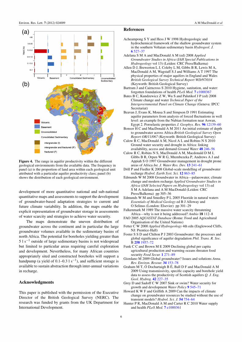
Figure 4. The range in aquifer productivity within the differentgeological environments from the available data. The frequency inpanel (a) is the proportion of land area within each geological unitattributed with a particular aquifer productivity class; panel (b)shows the distribution of each geological environment.
development of more quantitative national and sub-nationalquantitative maps and assessments to support the developmentof groundwater-based adaptation strategies to current andfuture climate variability. In addition, the maps enable theexplicit representation of groundwater storage in assessmentsof water scarcity and strategies to achieve water security.
The maps demonstrate the uneven distribution ofgroundwater across the continent and in particular the largegroundwater volumes available in the sedimentary basins ofnorth Africa. The potential for boreholes yielding greater than5 l s−1 outside of large sedimentary basins is not widespreadbut limited to particular areas requiring careful explorationand development. Nevertheless, for many African countriesappropriately sited and constructed boreholes will support ahandpump (a yield of 0.1–0.3 l s−1), and sufficient storage isavailable to sustain abstraction through inter-annual variationsin recharge.
Acknowledgments
This paper is published with the permission of the ExecutiveDirector of the British Geological Survey (NERC). Theresearch was funded by grants from the UK Department forInternational Development.
References
Acheampong S Y and Hess J W 1998 Hydrogeologic andhydrochemical framework of the shallow groundwater systemin the southern Voltaian sedimentary basin Hydrogeol. J.6 527–37
Adelana S M A and MacDonald A M (ed) 2008 AppliedGroundwater Studies in Africa (IAH Special Publications inHydrogeology vol 13) (Leiden: CRC Press/Balkema)
Allen D J, Brewerton L J, Coleby L M, Gibbs B R, Lewis M A,MacDonald A M, Wagstaff S J and Williams A T 1997 Thephysical properties of major aquifers in England and WalesBritish Geological Survey Technical Report WD/97/034(Keyworth: British Geological Survey)
Bartram J and Cairncross S 2010 Hygiene, sanitation, and water:forgotten foundations of health PLoS Med. 7 e1000367
Bates B C, Kundzewicz Z W, Wu S and Palutikof J P (ed) 2008Climate change and water Technical Paper of theIntergovernmental Panel on Climate Change (Geneva: IPCCSecretariat)
Beavan J, Evans K, Mousa S and Simpson D 1991 Estimatingaquifer parameters from analysis of forced fluctuations in welllevel: an example from the Nubian formation near Aswan,Egypt 2. Poroelastic properties J. Geophys. Res. 96 12139–60
Bonsor H C and MacDonald A M 2011 An initial estimate of depthto groundwater across Africa British Geological Survey OpenReport OR/11/067 (Keyworth: British Geological Survey)
Calow R C, MacDonald A M, Nicol A L and Robins N S 2010Ground water security and drought in Africa: linkingavailability, access and demand Ground Water 48 246–56
Calow R C, Robins N S, MacDonald A M, Macdonald D M J,Gibbs B R, Orpen W R G, Mtembezeka P, Andrews A J andAppiah S O 1997 Groundwater management in drought proneareas of Africa Int. J. Water Res. Dev. 13 241–61
Doll P and Fiedler K 2008 Global-scale modelling of groundwaterrecharge Hydrol. Earth Syst. Sci. 12 863–85
Edmunds W M 2008 Groundwater in Africa—palaeowater, climatechange and modern recharge Applied Groundwater Studies inAfrica (IAH Selected Papers on Hydrogeology vol 13) edS M A Adelana and A M MacDonald (Leiden: CRCPress/Balkema) pp 305–36
Edmunds W M and Smedley P L 2005 Fluoride in natural watersEssentials of Medical Geology ed B J Alloway andO Selinus (London: Elsevier) pp 301–29
Falkenmark M 1989 The massive water scarcity threateningAfrica—why is not it being addressed? Ambio 18 112–8
FAO 2005 AQUASTAT Database (Rome: Food and AgriculturalOrganisation of the United Nations)
Fetter C W 2000 Applied Hydrogeology 4th edn (Englewood Cliffs,NJ: Prentice-Hall)
Foster S S D and Chilton P J 2003 Groundwater: the processes andglobal significance of aquifer degradation Phil. Trans. R. Soc.B 258 1957–72
Funk C C and Brown M E 2009 Declining global per capitaagricultural production and warming oceans threaten foodsecurity Food Secur. 1 271–89
Giordano M 2009 Global groundwater? Issues and solutions Annu.Rev. Environ. Resour. 34 153–78
Graham M T, O Dochartaigh B E, Ball D F and MacDonald A M2009 Using transmissivity, specific capacity and borehole yielddata to assess the productivity of Scottish aquifers Q. J. Eng.Geol. Hydrog. 42 227–35
Grey D and Sadoff C W 2007 Sink or swim? Water security forgrowth and development Water Policy 9 545–71
Howard K W F and Griffith A 2009 Can the impacts of climatechange on groundwater resources be studied without the use oftransient models? Hydrol. Sci. J. 54 754–64
Hunter P R, MacDonald A M and Carter R C 2010 Water supplyand health PLoS Med. 7 e1000361
6
Environ. Res. Lett. 7 (2012) 024009 A M MacDonald et al
JMP 2010 Progress on Sanitation and Drinking Water, 2010 Update(Geneva and New York: WHO/UNICEF)
Jones M J 2010 The Groundwater Hydrology of the OkavangoBasin (Rome: Food and Agricultural Organisation of theUnited Nations)
Lott G K 1998 Thin section petrography of thirty-five samples fromboreholes in the Cretaceous succession of the Benue TroughNigeria British Geological Survey Technical ReportWH/98/174C (Keyworth: British Geological Survey)
MacDonald A M and Calow R C 2009 Developing groundwater forsecure water supplies in Africa Desalination 248 546–56
MacDonald A M, Calow R C, Macdonald D M J, Darling W G andO Dochartaigh B E 2009 What impact will climate changehave on rural water supplies in Africa? Hydrol. Sci. J.54 690–703
Morse D G 1994 Siliclastic reservoir rocks The PetroleumSystem—from Source Rock to Trap (American Association ofPetroleum Geologists Memoir vol 60) ed L B Magoon andW G Dow (Tulsa, OK: AAPG) pp 121–39
New M, Hulme M and Jones P 2000 Representing twentieth-centuryspace–time climate variability. Part II: development of1901–96 monthly grids of terrestrial surface climate J. Clim.13 2217–38
Nwankwo C N, Ekine A S and Nwosu L I 2009 Estimation of theheat flow variation in the Chad basin Nigeria J. Appl. Sci.Environ. Manage. 13 73–80
Pelig-Ba K B 2009 Analysis of stable isotope contents of surfaceand underground water in two main geological formations inthe northern region of Ghana W. Afr. J. Appl. Ecol. 15 65–72
Persits F, Ahlbrandt T, Tuttle M, Charpientier R, Brownfield M andTakahashi K 1997 Maps showing geology, oil and gas fieldsand geological provinces of Africa US Geol. Survey Open-FileReport 97-470A
Petford N 2003 Controls on primary porosity and permeabilitydevelopment in igneous rocks Hydrocarbons in CrystallineRocks (Geological Society London Special Publicationsvol 214) ed N Petford and K J W McCaffrey (London:Geological Society London) pp 93–107
Pfister S, Bayer P, Koehler A and Hellweg S 2011 Projected waterconsumption in future global agriculture: scenarios and relatedimpacts Sci. Total Environ. 409 4206–16
Samaila N K and Singh G P 2010 Study of porosity loss due tocompaction in the cretaceous upper Bima sandstone, upperBenue trough, NE Nigeria Earth Sci. India 3 105–14
Scanlon B R, Keese K E, Flint A F, Flint L E, Gaye C B,Edmunds W M and Simmers I 2006 Lobal synthesis ofgroundwater recharge in semiarid and arid regions Hydrol.Process. 20 3335–70
Seguin J J 2008 Carte Hydrogeologique de l’Afrique a l’echelle du1/10M (Orleans: Bureau de Recherches Geologiques etMinieres (BGRM))
Shiklomanov I and Rodda J (ed) 2003 World Water Resources at theBeginning of the Twenty-first Century (International HydrologySeries, UNESCO) (Cambridge: Cambridge University Press)
Siebert S, Burke J, Faures J M, Frenken K, Hoogeveen J, Doll P andPortmann F T 2010 Groundwater use for irrigation—a globalinventory Hydrol. Earth Syst. Sci. 14 1863–80
Smedley P L 1996 Arsenic in rural groundwater in Ghana J. Afr.Earth Sci. 22 459–70
Struckmeier W and Richts A 2008 Groundwater resources of theworld 1: 25 000 000 (Hannover: World-wide HydrogeologicalMapping and Assessment Programme (WHYMAP))
Taylor G and Eggleton R A 2001 Regolith Geology andGeomorphology (Chichester: Wiley)
Taylor R G, Tindimugaya C, Barker J A, Macdonald D M J andKulabako R 2010 Convergent radial tracing of viral and solutetransport in gneiss saprolite Ground Water 48 284–94
UNEP 2010 Africa Water Atlas (Nairobi: Division of Early Warningand Assessment (DEWA), United Nations EnvironmentProgramme)
Van der Voort I 2001 Risk based decision tool for managing andprotecting groundwater resources PhD Thesis University of theFree State, Bloemfontein (unpublished)
Vorosmarty C J, Douglas E M, Green P A and Revenga C 2005Geospatial indicators of emerging water stress: an applicationto Africa Ambio 34 230–6
Vorosmarty C J et al 2010 Global threats to human water securityand river biodiversity Nature 467 555–61
Wright E P, Benfield A C, Edmunds W M and Kitching R 1982Hydrogeology of the Kufra and Sirte basins, eastern LibyaQ. J. Eng. Geol. 15 83–103
7