Purpose - Planning Department | 規劃署...office accommodation, retail, hotel, and leisure space...
12
Civil Engineering and Development Department and Planning Department Agreement No. CE53/2008(CE) Planning and Engineering Study on Development of Lok Ma Chau Loop - Investigation Technical Report No. 4 - Preferred Land Use Option and Recommended Outline Development Plan Executive Summary Page 1 January 2012 Purpose Technical Report No. 4 presents the Recommended Outline Development Plan (RODP) formulated for the Lok Ma Chau Loop (LMC Loop) development and sets out the relevant planning objectives as well as the recommended land use and intensity for the development. The RODP provides the basis for detailed technical assessments to be undertaken (as detailed in Technical Report No. 5) aiming to confirm the engineering and technical feasibility of the proposed developments and infrastructures. The Study Area, consisting of Study Area A (Area A) and Study Area B (Area B) on the Hong Kong side, is shown in Figure 1. Overview of the Recommended Outline Development Plan The Preliminary Outline Development Plan (PODP), as presented in Technical Report No. 2B, set out the planning concepts and principles for developing the LMC Loop in a sustainable manner and proposed a preliminary land use framework to guide the future development of the Loop in terms of spatial land use arrangements, development intensity and building height as well as major infrastructures and transport networks. The PODP was put forward for public consultation during the Stage 1 Public Engagement (PE) completed in January 2011. Taking into account the public views collected in the Stage 1 PE, together with the preliminary results of various technical assessments carried out at that point in time, revisions to the PODP were made in order to address the public views and technical concerns, which form the basis for formulation of the Recommended Outline Development Plan (RODP) for the LMC Loop. The RODP has incorporated all the necessary revisions as appropriate resulting from the relevant public views and the technical findings, upon which the development proposals for the LMC Loop will be formulated. The PODP and RODP are presented in Figures 2 and 3 respectively. The major revisions to the development proposals for the LMC Loop development as reflected on the RODP mainly pertain to the following aspects: Interchangeability of “High-tech Research and Development (“R&D”) and “Cultural and Creative (C&C) Industries” uses to achieve a more flexible land use and layout design; Reducing the overall maximum building height from 15 storeys to 12 storeys and adjusting the maximum building height for respective uses of “Education” (from 15 storeys to 10 storeys), “High-tech R&D” and “C&C” industries (from 15 storeys to 12 storeys) and “Commercial” (from 12 storeys to 9 storeys), without affecting the overall development intensity, in order to minimize the impact on the flight paths of migratory birds; Adjusting the alignment of the Eastern Connection Road (ECR) with a section of the ECR adopting an underpass-cum-depressed road design to minimize impacts on the old meander of Shenzhen River and fishponds, as well as to minimize disturbance on the birds’ flight path and potential visual impacts; Instead of proposing one large District Cooling System (DCS) plant at the western part of the LMC Loop, two smaller DCS plants (i.e. respectively at the western and eastern ends of the LMC Loop closer to the cooling load centres) are proposed to help increase the energy efficiency and to allow greater flexibility in meeting the phasing arrangement of the LMC Loop development; Incorporating the alignment for the proposed direct linkage between the MTR LMC Station and the Loop; and
Transcript of Purpose - Planning Department | 規劃署...office accommodation, retail, hotel, and leisure space...
Civil Engineering and Development Department
and Planning Department
Agreement No. CE53/2008(CE)
Planning and Engineering Study on
Development of Lok Ma Chau Loop - Investigation
Technical Report No. 4 - Preferred Land Use Option
and Recommended Outline Development Plan
Executive Summary
Page 1 January 2012
Purpose
Technical Report No. 4 presents the Recommended Outline Development Plan (RODP) formulated for
the Lok Ma Chau Loop (LMC Loop) development and sets out the relevant planning objectives as well
as the recommended land use and intensity for the development. The RODP provides the basis for
detailed technical assessments to be undertaken (as detailed in Technical Report No. 5) aiming to
confirm the engineering and technical feasibility of the proposed developments and infrastructures.
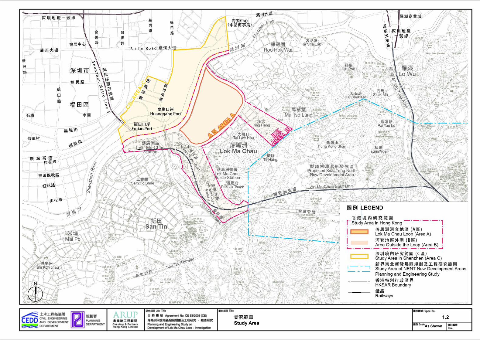
The Study Area, consisting of Study Area A (Area A) and Study Area B (Area B) on the Hong Kong
side, is shown in Figure 1.
Overview of the Recommended Outline Development Plan
The Preliminary Outline Development Plan (PODP), as presented in Technical Report No. 2B, set out
the planning concepts and principles for developing the LMC Loop in a sustainable manner and
proposed a preliminary land use framework to guide the future development of the Loop in terms of
spatial land use arrangements, development intensity and building height as well as major
infrastructures and transport networks.
The PODP was put forward for public consultation during the Stage 1 Public Engagement (PE)
completed in January 2011. Taking into account the public views collected in the Stage 1 PE, together
with the preliminary results of various technical assessments carried out at that point in time, revisions
to the PODP were made in order to address the public views and technical concerns, which form the
basis for formulation of the Recommended Outline Development Plan (RODP) for the LMC Loop. The
RODP has incorporated all the necessary revisions as appropriate resulting from the relevant public
views and the technical findings, upon which the development proposals for the LMC Loop will be
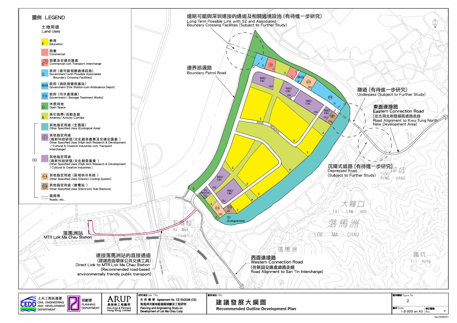
formulated. The PODP and RODP are presented in Figures 2 and 3 respectively.
The major revisions to the development proposals for the LMC Loop development as reflected on the
RODP mainly pertain to the following aspects:
Interchangeability of “High-tech Research and Development (“R&D”) and “Cultural and
Creative (C&C) Industries” uses to achieve a more flexible land use and layout design;
Reducing the overall maximum building height from 15 storeys to 12 storeys and adjusting the
maximum building height for respective uses of “Education” (from 15 storeys to 10 storeys),
“High-tech R&D” and “C&C” industries (from 15 storeys to 12 storeys) and “Commercial” (from
12 storeys to 9 storeys), without affecting the overall development intensity, in order to
minimize the impact on the flight paths of migratory birds;
Adjusting the alignment of the Eastern Connection Road (ECR) with a section of the ECR
adopting an underpass-cum-depressed road design to minimize impacts on the old meander
of Shenzhen River and fishponds, as well as to minimize disturbance on the birds’ flight path
and potential visual impacts;
Instead of proposing one large District Cooling System (DCS) plant at the western part of the
LMC Loop, two smaller DCS plants (i.e. respectively at the western and eastern ends of the
LMC Loop closer to the cooling load centres) are proposed to help increase the energy
efficiency and to allow greater flexibility in meeting the phasing arrangement of the LMC Loop
development;
Incorporating the alignment for the proposed direct linkage between the MTR LMC Station and
the Loop; and

Civil Engineering and Development Department
and Planning Department
Agreement No. CE53/2008(CE)
Planning and Engineering Study on
Development of Lok Ma Chau Loop - Investigation
Technical Report No. 4 - Preferred Land Use Option
and Recommended Outline Development Plan
Executive Summary
Page 2 January 2012
A site swap between the proposed Fire Station-cum-Ambulance Depot (FSAD) and the
Electricity Sub-Station in the eastern part of the LMC Loop in order to meet the operational
requirements of the facility.
Recommended Land Uses and Development Parameters
Based on the latest development proposal under the RODP, the land use breakdown is given in Table
1 below:
Table 1: Schedule of Uses and Areas for the RODP
Zoning Land Uses Approximate Area and %
Hectares %
E Education 22.9 26.1
C Commercial 0.5 0.6
Commercial cum Transport Interchange 0.7 0.8
G Government
Possible Associated Boundary Crossing Facilities 0.8 0.9
Sewage Treatment Works (STW) 2.1 2.4
Fire Station cum Ambulance Depot 0.4 0.5
O Open Space 10.6 12.1
A Amenity / Activity Corridor 15.9 18.1
OU Other Specified Uses
Ecological Area 12.8 14.6
High-Tech R&D / Cultural & Creative Industries cum Transport Interchange
0.4 0.5
High-Tech R&D / Cultural & Creative Industries 8.1 9.2
District Cooling System (DCS) 1.6 1.8
Electricity Sub-Stations 0.8 0.9
Roads^ 10.1 11.5
Total Development Area 87.7 100.0
^ Area includes the Boundary Patrol Road which is about 0.7 ha
Civil Engineering and Development Department
and Planning Department
Agreement No. CE53/2008(CE)
Planning and Engineering Study on
Development of Lok Ma Chau Loop - Investigation
Technical Report No. 4 - Preferred Land Use Option
and Recommended Outline Development Plan
Executive Summary
Page 3 January 2012
Apart from the reduced maximum building height and disposition of the concerned land use zones,
other major development parameters remain unchanged. Table 2 below sets out the major
development parameters under the RODP:
Table 2: Major Development Parameters under the RODP
Maximum no. of Students (approx.) 24,000
Employment Opportunities (approx.) 29,000*
Maximum Total Gross Floor Area (GFA) (m2)
Mainly including:
1,200,000
Education (including hostels) (m2) 720,000
High-tech R&D / Cultural and Creative Industries (m
2)
411,000
Commercial 60,000
Gross Plot Ratio 1.37
Maximum Building Height
Education 10 storeys
High-tech R&D / Cultural and Creative Industries
12 storeys
Commercial 9 storeys
* Including the existing employment opportunities to be relocated to LMC Loop
Education Use
It comprises 7 pieces of land in the LMC Loop covering an area of about 22.9 ha. The area can
provide a maximum GFA of 720,000m² for higher education use of which about 600,000m² is allotted
for academic space and about 120,000m² for hostels. The core education facilities provided include
academic teaching and research facilities, as well as other supporting facilities such as student
canteens and accommodation etc. The assumption reflects the current average HK standards. It is
estimated that the area could accommodate a maximum of 24,000 students of which about half of the
student population (i.e. approximately 12,000 students) is assumed to be resided in the Loop, and
6,000 staff.
High-Tech R&D / Cultural & Creative Uses
Comprising a total of 7 pieces of land located in the eastern and western ends of the LMC Loop, a
total area of about 8.5 ha, which can accommodate a total GFA of approximately 411,000m2, is
reserved for high-tech R&D and Cultural and Creative (C&C) industries uses. High-tech R&D in the
LMC Loop is anticipated to be some kind of research facilities to support higher education
development. The main intention is to create synergy between R&D industries and higher education
institutions and to encourage the formation of “research clusters” to facilitate the interflow of the talent
pool comprising different operators, researchers and academia. Possible C&C industries uses include
offices, workspaces, exhibition galleries, and performance space. The nature and mix of high-tech
R&D and C&C industries would depend on market demand and flexibility in the zoning (i.e. “Other
Specified Uses (OU) (High-tech Research & Development and Cultural & Creative Industries)”) is
provided on the development plots to allow the use of either or both land uses.
Commercial Uses
Comprising two sites (totalling about 1.2 ha) in the north-eastern end of the LMC Loop, these sites
would provide a total GFA of about 60,000m² for supporting commercial facilities, including general
office accommodation, retail, hotel, and leisure space as supporting facilities. A transport interchange
(TI), which includes basement carparking and park-and-ride facilities, is located at one of the sites to
Civil Engineering and Development Department
and Planning Department
Agreement No. CE53/2008(CE)
Planning and Engineering Study on
Development of Lok Ma Chau Loop - Investigation
Technical Report No. 4 - Preferred Land Use Option
and Recommended Outline Development Plan
Executive Summary
Page 4 January 2012
allow flexibility for implementation of the pedestrian-oriented environmentally friendly public transport
within the LMC Loop.
Government Uses
Possible Boundary Crossing Facilities
According to the comments received during Stage 1 PE, the public generally support the provision of a
direct and convenient linkage with Shenzhen (SZ). In order to encourage the interactions of users and
occupiers between the LMC Loop and Area C in SZ, a long-term possible pedestrian linkage across
the SZ River at the northern corner of the Loop is earmarked on the RODP. The exact location of the
linkage would be reviewed in conjunction with the future planning of Area C proposed by the SZ side,
in particular the future metro line development in SZ. Whether the linkage would be needed in the
long run will be subject to further discussion between HK and SZ governments.
In order to allow greater flexibility for future cross-boundary options, a site of about 0.8ha is reserved
at the northern corner of the LMC Loop for the development of a possible boundary crossing facilities
in order to provide convenient access for the users and visitors of the LMC Loop.
Sewage Treatment Works (STW)
In view of the option for a more compact design for the STW, a site of 2.1 ha is reserved at the eastern
part of the LMC Loop for the proposed on-site STW plant. In order to maintain flexibility at this stage,
the site is sufficient to accommodate an aboveground or an underground STW, as well as possible
reclaimed water treatment facilities if adopted.
Other Government, Institution and Community (G/IC) Uses
Medical and health facilities - It is stated in the Hong Kong Planning Standards and Guidelines
(HKPSG)that one clinic / health centre should be provided for every 100,000 persons. It is
anticipated that students and university staff would be served by university clinics within the
university campus. Alternatively, health care facilities within the future Kwu Tung North (KTN)
New Development Area (NDA) could also serve the users of the LMC Loop. On this
assumption, it is anticipated no additional health facilities would be required.
Police station – There are no applicable standards in the HKPSG for provision of such a
facility at the LMC Loop. There is an existing LMC Police Station in the vicinity which could
serve the needs of the LMC Loop. If additional police resources are required, a sub-divisional
police station or police post could be considered to be provided in Government sites as the
future Boundary Control Point building, which will be subject to further discussion with relevant
bureaux and departments.
Fire service and ambulance depot – Fire and ambulance service facilities could either make
use of the provision in the KTN NDA or be provided within the LMC Loop. A site of 0.4 ha
located at the eastern end of the LMC Loop in between the “C” site and the proposed eastern
DCS site has been reserved on the RODP for the provision of such facility.
Post office – Post office could be accommodated within the university or private buildings if
required.
Amenity / Activity Corridor
In order to promote social interaction, amenity / activity corridors that run through the site in north-
south and east-west directions are proposed on the RODP. The planning intention of this zoning is to
provide a continuous people-oriented environment for promoting social harmony, economic vibrancy,
as well as environmental performance. In addition to providing a pedestrian boulevard with a variety of

Civil Engineering and Development Department
and Planning Department
Agreement No. CE53/2008(CE)
Planning and Engineering Study on
Development of Lok Ma Chau Loop - Investigation
Technical Report No. 4 - Preferred Land Use Option
and Recommended Outline Development Plan
Executive Summary
Page 5 January 2012
informal outdoor activities such as exhibitions, concerts, street performance, and ancillary outdoor
seating areas of cafes/restaurants and retail kiosks, etc., this amenity / activity corridor also serves as
view corridors and breezeways which contribute to enhancing the environmental performance of the
site by improving the micro-climate and air ventilation. The unique spatial form of the north-south
direction amenity/activity corridors creates interconnecting visual links between the landscape
amenities on both sides of the SZ River and further enhances the visual permeability of the site.
Public Open Space
About 10.6 ha of land within the LMC Loop is allocated for open space. The north-eastern and south-
western banks of the LMC Loop along the Old SZ River Meander, together with the northern edge
along the SZ River, form a 2km long riverside promenade which is designed to create a social and
leisure waterfront environment for public enjoyment. It is intended that the design of this promenade
would echo with the future riverside area across the SZ River and provide a peaceful integration
between the developments along both sides of the SZ River. These landscaped areas also serve as a
visual buffer to the Secondary Boundary Fence along the New Boundary Patrol Road. Landscape
treatment will be applied to the north-eastern and south-western banks of the LMC Loop along the Old
SZ River Meander in order to screen off potential disturbance to the Meander and wetland habitats at
Hoo Hok Wai.
Other Specified Uses
Ecological Area (EA)
According to the ecological surveys carried out for the Study, the LMC Loop and surrounding areas
form an important corridor for wetland species between the fish pond habitats at Hoo Hok Wai and
wetlands to the west of the LMC BCP. On this basis, the EA, which is located along the southern
boundary of the LMC Loop occupying about 12.8 ha of the total site area, is delineated on the RODP.
The design of the EA is driven by the ecological functions to be compensated, as well as, the habitat
requirements of the target species.
The creation of the EA aims to enhance and create areas of reedbed compensating the habitat loss as
well as providing a corridor connecting ecologically important areas to the east and west of the LMC
Loop. The provision of a purpose-built area of compensatory reed marsh habitat facilitates more
effective ecological enhancement through targeted design and avoidance of the fragmentation and
disturbance impacts that might result if it was partially surrounded by development. In addition to
reedbed compensation, this multi-functional area also protects the existing birds’ flight lines and
mammal movement corridors. The detailed design of the EA will be undertaken in the later stage of
the Study.
District Cooling System (DCS)
As part of the green initiatives and taking into consideration the objectives of increasing the energy
efficiency of the DCS and to allow greater flexibility in meeting the phasing arrangement of the
development, subject to further study on the financial viability, two smaller DCS plants are proposed to
be provided within the LMC Loop. The two sites, each located on either ends of the LMC Loop, total
approximately 1.6 ha of land. The choice of location for the DCS plants was made after careful
consideration on factors such as plant efficiency based on its proximity to the cooling load centre, the
overall planning and design of the site, as well as planning of Area C in SZ. Detailed technical
assessment of the DCS was discussed in the Green Initiatives Assessment of Technical Report No. 5.

Civil Engineering and Development Department
and Planning Department
Agreement No. CE53/2008(CE)
Planning and Engineering Study on
Development of Lok Ma Chau Loop - Investigation
Technical Report No. 4 - Preferred Land Use Option
and Recommended Outline Development Plan
Executive Summary
Page 6 January 2012
Technical and Engineering Considerations for LMC Loop
Transport Network
The objective of the transport system for the LMC Loop is to establish a system that could minimise
road space for vehicular traffic movements to enhance the quality of environment, whilst satisfying the
basic needs for accessibility and servicing requirements with convenience to occupants / users.
Figure 4 shows the access and circulation arrangement within the LMC Loop.
Internal Transport
The general transport strategy for the LMC Loop is to provide a pedestrian friendly campus
environment. Two Transport Interchanges (TIs) are proposed with below-ground carpaking and
ancillary park-and-ride facilities to facilitate the parking of most of the private cars at the fringe of the
LMC Loop resulting in reduction of carbon movements inside the campus. The internal areas will be
accessed mainly by walking and environmentally friendly / green public transport modes such as
electric buses. Cycling is encouraged by providing a comprehensive internal transport and pedestrian
network. Loading/unloading facilities will be planned at suitable location such that they could minimise
the impact of vehicular traffic on pedestrian and cycling activities within the LMC Loop.
External Connections
The nearest major transport node from the LMC Loop is the MTR LMC Station, which could serve the
LMC Loop’s cross-boundary users and railway passengers. The possibility of a direct linkage between
the LMC Loop and the existing MTR LMC Station using some form of Environmentally Friendly
Transport System (EFTS) were being reviewed, and several operational modes have been considered
for this linkage: footbridge-cum-travellator; non-road based EFTS; and road-based EFTS. Technical,
financial and economical assessments for the various connection options will be detailed in transport
and traffic impact assessment of Technical Report No. 5.
Other major existing transport node in the vicinity is the San Tin public transport interchange, whereby
together with the use of the adjacent open-air car park spaces nearby, a park-and-ride system may be
implemented to control the volume of traffic using LMC Road and entering the LMC Loop area.
The most direct road access to the development is anticipated to be the connection between the
western part of LMC Loop with the San Tin Highway / Fanling Highway. Several alignment options
have been investigated for the Western Connection Road (WCR). Based on the assessments from
various technical considerations, the option of widening the existing Lok Ma Chau Road and Ha Wan
Tsuen Road would be adopted. The WCR would be linked with Fanling Highway/San Tin which will
be further connected to the rest of the territories. Details of the preliminary schemes and the
preliminary design of the road layout of the WCR will be detailed in transport and traffic impact
assessment of Technical Report No. 5.
Upon full development of the LMC Loop, the WCR alone will not be able to handle all the traffic
generated by the development. In addition to handling the additional traffic and providing an
alternative access road for emergency/contingency purposes, the Eastern Connection Road (ECR)
would help improve the connectivity of the LMC Loop with surrounding developments, particularly with
KTN NDA. In response to the public aspirations and taking account of the technical assessments on
different design options, it is proposed a section of the ECR adopting an underpass-cum-depressed
road design in order to minimize impacts on fish ponds, potential visual impacts and bird flight path
disturbance.
Civil Engineering and Development Department
and Planning Department
Agreement No. CE53/2008(CE)
Planning and Engineering Study on
Development of Lok Ma Chau Loop - Investigation
Technical Report No. 4 - Preferred Land Use Option
and Recommended Outline Development Plan
Executive Summary
Page 7 January 2012
In order to further enhance the convenience of users communiting between the Loop and SZ, a
possible long-term additional pedestrian connection at the northern corner of the LMC Loop across the
SZ River has been considered for providing a more direct connection with the planned station of the
future Metro Line 7 in the SZ side. A site has been reserved to accommodate the boundary crossing
facilities for pedestrian as well as ancillary facilities for handling additional demand for public transport
facilities.
Other Infrastructure and Utilities
Drainage
In order to minimise any adverse impact to the Old SZ River Meander, a new drainage system in Area
A is planned for LMC Loop development, which will collect stormwater from the development sites and
drain into Shenzhen (SZ) River. As part of the sustainable drainage design, part of the runoff from the
development site will be conveyed directly to SZ River and remaining will be discharge to SZ River
through the proposed Ecological Area/Wetland. The scheme was detailed in the drainage impact
assessment of Technical Report No. 5.
Water Supply
The proposed development site is located at the interface boundary of supply zone of Sheung Shui
Water Treatment Works (SSWTW) and Ngau Tam Mei WTW (NTMWTW). In order to meet the water
demand due to first population intake at the LMCL development site by 2020, a new Kwu Tung North
(KTN) FWSR and associated waterworks are required. With regard to flushing water demand for
proposed development in the LMC Loop, it is anticipated that such demand can be met by either fresh
water or treated sewage effluent. The implementation of flushing water service reservoir and
associated distribution main shall be reviewed during course of this Study by taking into consideration
the public acceptance on using TSE for non-potable uses. Details of such will be covered in the water
supply and utilities impact assessment of Technical Report No. 5.
Power Supply
Further discussions with China Light and Power Company (CLP) indicated that the design of a ring
network and dual backup supply system would be more suitable in order to provide a reliable and
secure supply of electricity. Against this background, 2 sites within the Loop have been reserved for
the construction at each of the 132kV electricity sub-station (ESS). New 132 kV cable circuits would
be laid along LMC Road, Ha Wan Tsuen Road and the proposed road extension to Area A to connect
with the proposed ESSs. Details of such will be covered in water supply and utilities impact
assessment of Technical Report No. 5.
Gas Supply
The future plan for gas supply to the LMC Loop would depend on the predicted gas demand of the
proposed LMC Loop development. As advised by Hong Kong and China Gas Company Limited
(HKCG), it was highly likely that the existing medium pressure (MP) along Lok Ma Chau Road would
be insufficient to support the new demand from the LMC Loop. A new MP gas pipe from the HKCG’s
Fanling West Offtake Station via Castle Peak Road would be required. Land would be reserved within
the Loop for the construction of gas governor kiosk(s).
Telecommunication
Telecommunication cables can be fed from the existing services along LMC Road to the west of Area
A. Feeding services from the proposed developments in KTN via ECR to the LMC Loop is also an
alternative.

Civil Engineering and Development Department
and Planning Department
Agreement No. CE53/2008(CE)
Planning and Engineering Study on
Development of Lok Ma Chau Loop - Investigation
Technical Report No. 4 - Preferred Land Use Option
and Recommended Outline Development Plan
Executive Summary
Page 8 January 2012
Site Formation
A preliminary assessment based on the maximum water levels under the Review of Drainage Master
Plans in Yuen Long and North District Feasibility Study for SZ River indicates that site formation levels
between +5.80mPD to +5.90mPD would be adequate in terms of coping with the risk of flooding. The
precise level would be confirmed after a detailed hydraulic analysis has been carried out as part of the
drainage impact assessment. For details of technical assessment, please refer to site formation
assessment in Technical Report No. 5.
Land Use Review alongside Proposed Infrastructure in Area B
Land in Area B is mainly to provide external connection roads and essential infrastructure facilities to
support the development of the LMC Loop. Having reviewed the existing and planned land uses in
Area B, it is considered that there is scope to strengthen synergy between the land uses of the LMC
Loop and those in its adjoining areas.
A separate land use review to identify development potential for the areas adjacent to the connection
roads leading to the Loop is being undertaken.
1.2
As Shown
研究範圍 Study Area
peter-ly.chan
Typewriter

2.3.3 初步發展大綱圖 Preliminary Outline Development Plan NTS
peter-ly.chan
Typewriter
peter-ly.chan
Typewriter
3

4.5.3 交通可達性與路線圖 Access and Circulation Plan
NTS
peter-ly.chan
Typewriter