Puente Palo Loop D - Trek Sierra Nevada · Puente Palo Loop D 1300 1350 1400 1450 1500 1550 1600...
2
A varied circuit that takes you through dense forest, orchards and idyllic pastureland. There is welcome shade as you climb up at the start of the walk, but after you reach the highest point of the walk there are lovely views over the Órgiva valley, the Rules reservoir and the hills beyond. If you’re staying in one of the villages in the Poquiera gorge, this is just a very short drive away in the next valley. Medium Easy Medium Puente Palo Loop 1300 1350 1400 1450 1500 1550 1600 1650 1700 1750 1800 0 2 4 6 8 10 12 14 Altitude (m) Distance (km) Getting There By Car: From Granada, take the E-902/A-44 towards Motril. Take exit 164 and take the A-348 towards Lanjaron. Carry on past Lanjaron and after about a further 8km turn left onto the A-4132, marked towards Trevelez (the turning is just after you enter Orgiva). Pass the turn-off for Soportujar and shortly afterwards you will see a small chapel on your right (Ermita del Padre Eterno). Take the left turning here, onto an asphalted (but at time of writing very poorly maintained) road. Follow this road for about 4km until you get to a tourist complex offering horse riding. From this point, the road is no longer surfaced, but a few hundred metres further on you’ll see a small parking area with walking signs, where the route starts. By bus: This walk is not easily accessible by bus. Key Facts Length 13.5 km Time 4 hours Min/Max Altitude 1346 m /1786 m Accumulated height difference 544 m Season All year The walk is made up of three sections, firstly taking the marked path PR-A 22, then following a section of the GR-240 Sulayr long distance walking route, and finally taking a forest road to complete the loop. We do not recommend taking water from the irrigation channels, so bring sufficient drinking water with you. © Trek Sierra Nevada, October 2010 • May not be altered or sold • www.treksierranevada.com D ISCLAIMER: While we have made every effort to ensure that this information is accurate, conditions can change, and you are responsible for your own safety.
Transcript of Puente Palo Loop D - Trek Sierra Nevada · Puente Palo Loop D 1300 1350 1400 1450 1500 1550 1600...

A varied circuit that takes you
through dense forest, orchards
and idyllic pastureland. There is
welcome shade as you climb up
at the start of the walk, but after
you reach the highest point of
the walk there are lovely views
over the Órgiva
valley, the Rules
reservoir and the
hills beyond. If
you’re staying in
one of the
villages in the
Poquiera gorge,
this is just a very
short drive away
in the next
valley.
Medium
Easy
Medium
Puente Palo Loop
1300
1350
1400
1450
1500
1550
1600
1650
1700
1750
1800
0 2 4 6 8 10 12 14
Alt
itu
de
(m)
Distance (km)
Getting There
By Car: From Granada, take the E-902/A-44 towards
Motril. Take exit 164 and take the A-348 towards
Lanjaron. Carry on past Lanjaron and after about a
further 8km turn left onto the A-4132, marked towards
Trevelez (the turning is just after you enter Orgiva).
Pass the turn-off for Soportujar and shortly afterwards
you will see a small chapel on your right (Ermita del
Padre Eterno). Take the left turning here, onto an
asphalted (but at time of writing very poorly
maintained) road. Follow this road for about 4km until
you get to a tourist complex offering horse riding. From
this point, the road is no longer surfaced, but a few
hundred metres further on you’ll see a small parking
area with walking signs, where the route starts.
By bus: This walk is not easily accessible by bus.
Key Facts
Length 13.5 km
Time 4 hours
Min/Max Altitude 1346 m /1786 m
Accumulated height
difference 544 m
Season All year
The walk is made up of
three sections, firstly
taking the marked path
PR-A 22, then following
a section of the GR-240
Sulayr long distance
walking route, and
finally taking a forest
road to complete the
loop.
We do not recommend
taking water from the
irrigation channels, so
bring sufficient drinking
water with you.
© Trek Sierra Nevada, October 2010 • May not be altered or sold • www.treksierranevada.com
D ISCLAIMER: While we have
made every effort to ensure
that this information is accurate,
conditions can change, and you are
responsible for your own safety.
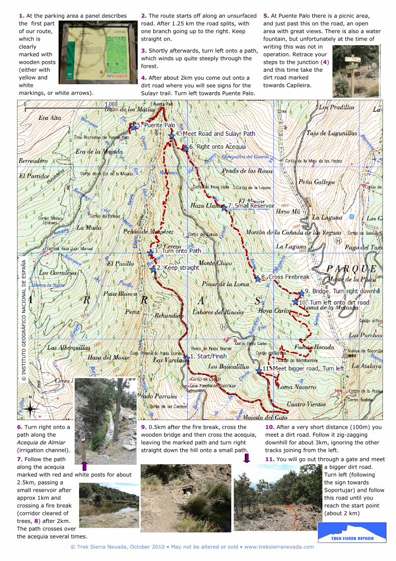
1. At the parking area a panel describes
the first part
of our route,
which is
clearly
marked with
wooden posts
(either with
yellow and
white
markings, or white arrows).
2. The route starts off along an unsurfaced
road. After 1.25 km the road splits, with
one branch going up to the right. Keep
straight on.
3. Shortly afterwards, turn left onto a path,
which winds up quite steeply through the
forest.
4. After about 2km you come out onto a
dirt road where you will see signs for the
Sulayr trail. Turn left towards Puente Palo.
5. At Puente Palo there is a picnic area,
and just past this on the road, an open
area with great views. There is also a water
fountain, but unfortunately at the time of
writing this was not in
operation. Retrace your
steps to the junction (4)
and this time take the
dirt road marked
towards Capileira.
6. Turn right onto a
path along the
Acequia de Almiar
(irrigation channel).
7. Follow the path
along the acequia
marked with red and white posts for about
2.5km, passing a
small reservoir after
approx 1km and
crossing a fire break
(corridor cleared of
trees, 8) after 2km.
The path crosses over
the acequia several times.
9. 0.5km after the fire break, cross the
wooden bridge and then cross the acequia,
leaving the marked path and turn right
straight down the hill onto a small path.
10. After a very short distance (100m) you
meet a dirt road. Follow it zig-zagging
downhill for about 3km, ignoring the other
tracks joining from the left.
11. You will go out through a gate and meet
a bigger dirt road.
Turn left (following
the sign towards
Soportujar) and follow
this road until you
reach the start point
(about 2 km)
© I
NSTIT
UTO
GEO
GRÁ
FIC
O N
AC
ION
AL D
E E
SPAÑ
A
© Trek Sierra Nevada, October 2010 • May not be altered or sold • www.treksierranevada.com