PUBLIC SCOPING MEETINGS - Alaska Department of...
29
EASTERN TANANA AREA PLAN PUBLIC SCOPING MEETINGS Meeting Structure: ¾ 20 min. Map and material review ¾ 20 min. Welcome, staff introductions, and presentation ¾ 10 min. Process related question and answer period ¾ 60 min. Facilitated topic discussions (30 min at each station) ¾ 10 min. Summary and wrap up
Transcript of PUBLIC SCOPING MEETINGS - Alaska Department of...

EASTERN TANANA AREA PLANPUBLIC SCOPING MEETINGS
Meeting Structure:
20 min. Map and material review20 min. Welcome, staff introductions, and presentation10 min. Process related question and answer period60 min. Facilitated topic discussions (30 min at each station)10 min. Summary and wrap up

RULES TO THE MEETINGRULES TO THE MEETING
Be respectful and courteous to others
Do not interrupt others that are speaking
Please hold questions until after thePlease hold questions until after the presentation

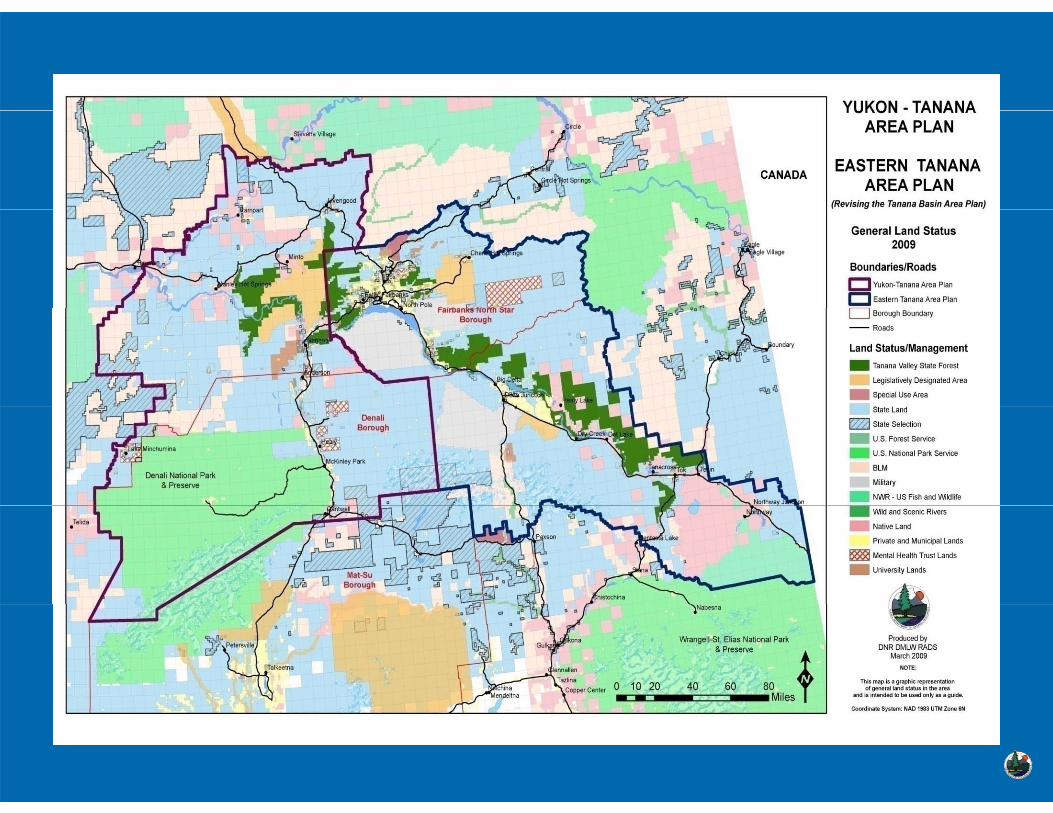
EASTERN TANANAEASTERN TANANAEASTERN TANANAEASTERN TANANAAREA PLANAREA PLANA EA ANA EA AN
For State LandsFor State Lands
(Revising the eastern portion of the (Revising the eastern portion of the Tanana Basin Area Plan)Tanana Basin Area Plan)
PUBLIC SCOPING MEETINGSPUBLIC SCOPING MEETINGSA il 2009A il 2009April 2009April 2009
Alaska Department of Natural ResourcesAlaska Department of Natural ResourcesDi i io of Mi i La d &WateDi i io of Mi i La d &WateDivision of Mining, Land & WaterDivision of Mining, Land & WaterResource Assessment & Development SectionResource Assessment & Development Section

PURPOSE OF THE MEETING
DNR is revising the Tanana Basin Area Plan (TBAP) through the development of two plans: the Eastern Tanana Area Planthe development of two plans: the Eastern Tanana Area Plan (ETAP), and the Yukon Tanana Area Plan (YTAP)
This meeting will focus on the Eastern Tanana Area Plan
We are here to provide the public with information about the planning process, answer questions, and most importantly p g p , q , p yencourage the public to provide written comments on how you use the state lands and how you would like to see them used in the future
NOTE: This Revision only affects state-owned and selected lands

The Planning area contains approximately 6.5 million acres of state owned and selected lands and over 1 million acres of LDA(s)
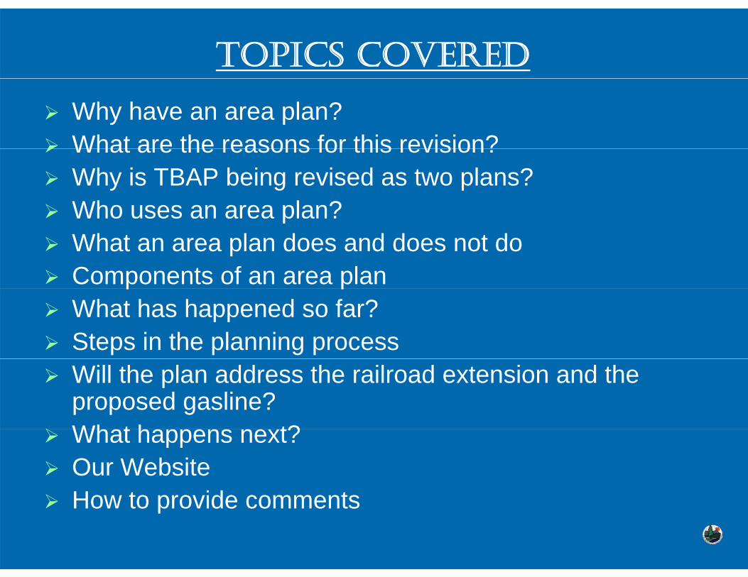
TOPICS COVERED
Why have an area plan?What are the reasons for this revision?What are the reasons for this revision?Why is TBAP being revised as two plans?Who uses an area plan?o uses a a ea p aWhat an area plan does and does not doComponents of an area planp pWhat has happened so far?Steps in the planning processWill the plan address the railroad extension and the proposed gasline?Wh t h t?What happens next?Our WebsiteHow to provide commentsHow to provide comments

WHY HAVE AN AREA PLAN?
Constitutional Mandate for Natural Resources:Constitutional Mandate for Natural Resources:Constitutional Mandate for Natural Resources:Constitutional Mandate for Natural Resources:
Article VIII Section 1 of the Alaska State ConstitutionArticle VIII, Section 1 of the Alaska State Constitution states: “It is the policy of the State to encourage the settlement of its land and the development of its presources by making them available for maximum use consistent with the public interest.”
WHY HAVE AN AREA PLAN? WHY HAVE AN AREA PLAN?
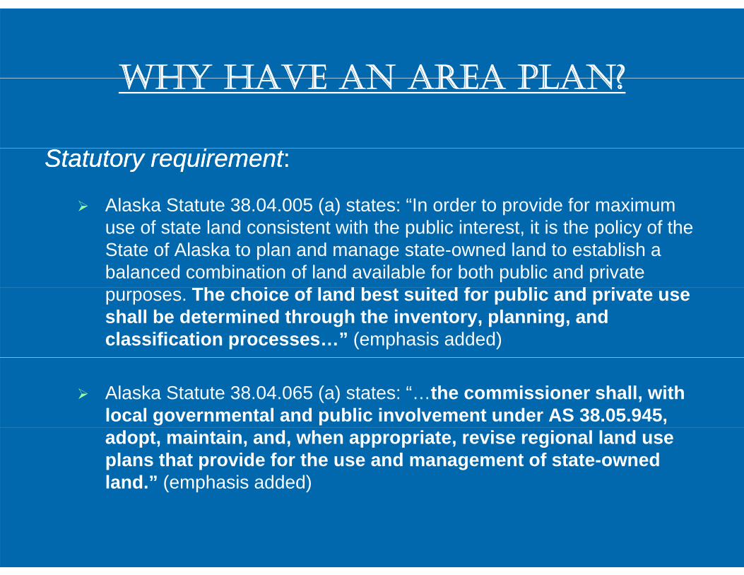
Statutory requirementStatutory requirement::
Alaska Statute 38.04.005 (a) states: “In order to provide for maximum use of state land consistent with the public interest, it is the policy of the State of Alaska to plan and manage state-owned land to establish a balanced combination of land available for both public and private
Th h i f l d b t it d f bli d i tpurposes. The choice of land best suited for public and private use shall be determined through the inventory, planning, and classification processes…” (emphasis added)
Alaska Statute 38.04.065 (a) states: “…the commissioner shall, with local governmental and public involvement under AS 38.05.945, adopt, maintain, and, when appropriate, revise regional land use plans that provide for the use and management of state-owned land.” (emphasis added)

WHY HAVE AN AREA PLAN?WHY HAVE AN AREA PLAN?
DNR Mission Statement:DNR Mission Statement:Develop, conserve, and maximize the use of Alaska’sDevelop, conserve, and maximize the use of Alaska’snatural resources consistent with the public interestnatural resources consistent with the public interestnatural resources consistent with the public interestnatural resources consistent with the public interest
The Department uses area plans as the basis of managementThe Department uses area plans as the basis of management for state land and resourcesBetter and more informed decision making for DNR adjudicatorsPlanning provides a way to sort though the numerous possibilities of using state landpossibilities of using state landProvides the opportunity for the public to participate in decision-making processdecision making process

REASONS FOR THE TBAP REVISIONREASONS FOR THE TBAP REVISION
Identified as a high priority for the Departmentg p y pOriginal area plan was adopted over 20 years ago, Policies identified in Chapter 2 are outdated and
f l d i i d b DNRreference programs no longer administered by DNR such as the homesteading program, and public use cabinscabinsChanges in land ownership patterns related to:
Settlement agreements (University and Mental g ( yHealth Trust), Land disposal programs, St t d N ti l dState and Native land conveyances, Municipal entitlements

REASONS (CONTINUED)REASONS (CONTINUED)
Outdated land classifications, some from the early 80’sThe 1991 TBAP has been amended over 50 timesThe 1991 TBAP has been amended over 50 timesMany remnant and unplanned parcels of state land exist.Provide a sufficient land base for the state land disposal and agricultural programs The need for consistency in DNR management policies and area plan formatsand area plan formats.
WHY IS TBAP BEING REVISED AS TWO PLANS?
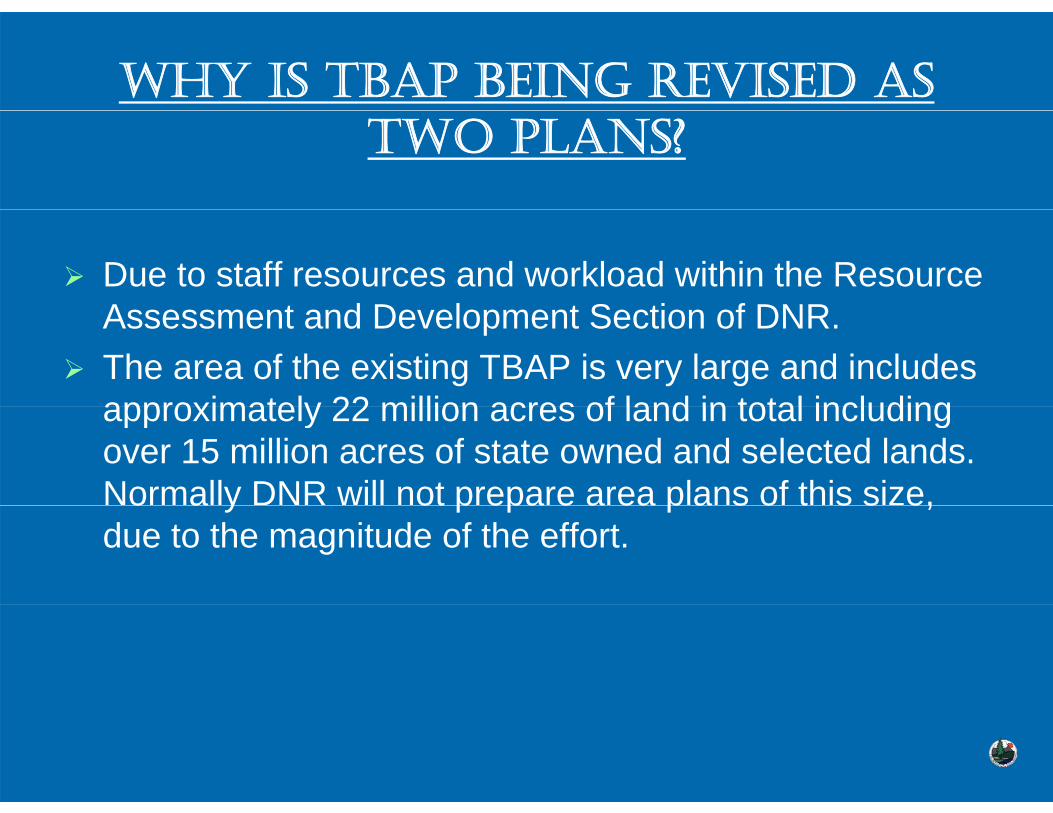
Due to staff resources and workload within the Resource A t d D l t S ti f DNRAssessment and Development Section of DNR.The area of the existing TBAP is very large and includes approximately 22 million acres of land in total includingapproximately 22 million acres of land in total including over 15 million acres of state owned and selected lands. Normally DNR will not prepare area plans of this size, o a y ot p epa e a ea p a s o t s s e,due to the magnitude of the effort.

WHO USES AN AREA PLAN?WHO USES AN AREA PLAN?
Primarily used by DNR for management of state lands and resources. Including state personnel such as:
ADNR P it dj di t d l i t ffADNR Permit adjudicators and leasing staffDivisions within the DepartmentADF&G j t i t ffADF&G project review staff
fAlso used by members of the public, interest groups and Industry

WHAT THE PLAN DOES
Serves as the basis for the management of state land and waters within the planning areaand waters within the planning areaProvides management direction for DNR decisions on state landstate landProvides management intent, land use designations, and management guidelines for specific geographic regionsg g p g g p gAllocates land uses and thereby resolves land use conflicts, and where appropriate provides conditions for pp p puses to make them compatible
Designates areas for active use (Forestry, Settlement, Material Sites)Sites)Designates areas for protection (Habitat, Water Resources, Public Recreation))
Identifies land to be retained or disposed

WHAT THE PLAN DOESN’T DO
Does not apply to private, University, Mental Health Trust, Borough, or Federal LandsDoes not apply to state parks, refuges, and critical habitat areas (except classifications)Does not address allocation, regulation, or harvesting of fi h d ildlif t k ( ADF&G f ti )fish and wildlife stocks (an ADF&G function)Does not address site specific issues (boating, camping, hiking fishing or facility development)hiking, fishing, or facility development)Does not provide a comprehensive inventory of land ownershipownershipDoes not regulate “Generally Allowed Uses” on state landslands

COMPONENTS OF AN AREA PLAN
Chapter 1 – Introduction, background and scopep g pChapter 2 – Area wide Land Management Policies for resources and uses
Ch t 3 U it S ifi L d M t P li iChapter 3 – Unit Specific Land Management Policies•Designation explanation•Region Descriptions•Region Descriptions•Resource Allocation Tables: plan designations and management intent for specific geographic areasg p g g p
Chapter 4 – Implementation and Recommendations -Relationships and recommendations or actions to i l t th limplement the plan

WHAT HAS HAPPENED SO FAR?Review of existing data and identify additional data needsGathering information, land inventory and identification of issues and detailed mapping and GIS analysisDeveloped a website that includes planning related material, background and mapsPreparation of Scoping Meetings and noticing through:
Online Public NoticesS i fl il d t ll l l t ffi f di lScoping flyers mailed to all local post offices for displayPostings in community centers and around town Meeting information and ETAP details emailed or mailed toMeeting information and ETAP details emailed or mailed to approximately 300 individuals, stakeholder groups, and agenciesDisplay ads in Fairbanks Daily News MinerMedia ReleasesPublic Service Announcements

THE PLANNING PROCESS
1.1. Gather Information.Gather Information. Information is collected about natural resources, Information is collected about natural resources, present land use, land ownership, local history and economypresent land use, land ownership, local history and economypresent land use, land ownership, local history and economypresent land use, land ownership, local history and economy
2.2. Identify Issues.Identify Issues. Public Scoping Meetings are held to learn about local Public Scoping Meetings are held to learn about local interests and issues with state lands.interests and issues with state lands. This also helps to get the word This also helps to get the word out that the planning process has begunout that the planning process has begun (spring/summer2009 )(spring/summer2009 )out that the planning process has begun.out that the planning process has begun. (spring/summer2009 ) (spring/summer2009 )
3.3. Prepare Public Review Draft.Prepare Public Review Draft. Using resource information and public Using resource information and public and agency commentsand agency comments
4.4. Public Review Period.Public Review Period. The Public Review Draft is made available, The Public Review Draft is made available, and public meetings are held to discuss the draft, receive comments, and public meetings are held to discuss the draft, receive comments, and identify parts that may need to be changed.and identify parts that may need to be changed.
5.5. Prepare Final Draft.Prepare Final Draft. The plan will be finalized based on public The plan will be finalized based on public comments and internal direction provided by leadership in DNR.comments and internal direction provided by leadership in DNR.
66 Adoption by Commissioner of DNRAdoption by Commissioner of DNR Signs the plan which thenSigns the plan which then6.6. Adoption by Commissioner of DNR.Adoption by Commissioner of DNR. Signs the plan which then Signs the plan which then guides management decisions on state land in the planning areaguides management decisions on state land in the planning area

WILL THE PLAN ADDRESS THE WILL THE PLAN ADDRESS THE PROPOSED GASLINE AND RAILROAD EXTENSION? RAILROAD EXTENSION?
Yes and No

PROPOSED GASLINE AND RAILROAD EXTENSIONRAILROAD EXTENSION
The area plan will not determine the locations of the railroad extension or the gasline routes. This is done through the EIS and permitting processesThe plan will however acknowledge proposals for theThe plan will however acknowledge proposals for the facilities and provide management intent language to facilitate their development pLanguage will be included to preserve public access and may provide guidance for review or issuance of certain authorizations that may affect these projectsIf a known route(s) has been identified at time of writing, a
id ill lik l b d i t d T t ti C idcorridor will likely be designated as Transportation Corridor Land

RAILROAD EXTENSION
Preferred routes that cross various land ownership tt h b h th F d l S fpatterns have been shown on the Federal Surface
Transportation Board EIS mapsAS 42 40 460 provides DNR with the legal framework forAS 42.40.460 provides DNR with the legal framework for a reservation and conveyance process, specifically for the reservation of a 500ft transportation corridor,the reservation of a 500ft transportation corridor, although only 200ft would be conveyed to the railroad as determined appropriate through the process Public access points across the proposed corridors are being identified through a separate agency and public
ireview process

PROPOSED GASLINE
No applications have been submitted for a state Right of pp gWay Lease and no exact locations or timeframes have been givenIt may basically follow the TAPS line to Delta, and be buried in generalNRO h b i i it f li i fi ldNRO have been issuing permits for preliminary field studies, generally geotechnical in natureJPO ill begin the Right of Wa Lease process once anJPO will begin the Right of Way Lease process once an application has been filed

WHERE CAN I GET MORE WHERE CAN I GET MORE INFORMATION
State Contacts:State Contacts:Railroad Extension
• Don Perrin, Office of Project Management, DNR907 269 7476907-269-7476
• Jeanne Proulx, Northern Region Office, DNR907-451-2722907 451 2722
Proposed Gasline• Joint Pipeline Office, DNR

WHAT HAPPENS NEXT IN THE PLANNING PROCESS?
Th bli i i d f t ill dThe public scoping period for comments will end June 5, 2009F ll i th l f th t i d ll tFollowing the close of the comment period all comments will be read and reviewed. A planning update will be developed to informA planning update will be developed to inform individuals, stakeholder groups, and agencies on the results of the public scoping process.results of the public scoping process.A Public Review Draft of the plan will be developed considering agency and public comments. g g y pDue to the size of the area, it could take at least 12 months before a draft plan is ready for public review.

WEBSITEWEBSITE
PLEASE VISIT OUR PLANNING WEBSITE FOR PLEASE VISIT OUR PLANNING WEBSITE FOR PLEASE VISIT OUR PLANNING WEBSITE FOR PLEASE VISIT OUR PLANNING WEBSITE FOR UPDATED INFORMATION UPDATED INFORMATION
www.dnr.state.ak.us/mlw/planningwww.dnr.state.ak.us/mlw/planning
Alaska Department of Natural ResourcesAlaska Department of Natural ResourcesDivision of Mining, Land & Water
Resource Assessment & Development Section

HOW TO PROVIDE COMMENTSHOW TO PROVIDE COMMENTS
Your written comments are encouraged during this planning Your written comments are encouraged during this planning phase and phase and should be submitted by 5:00pm June 5, 2009should be submitted by 5:00pm June 5, 2009 by by pp y p ,y p , yymail, email, fax or on our website. Although there will be mail, email, fax or on our website. Although there will be several “official” periods when public comments are sought, several “official” periods when public comments are sought,
f ff fplease feel free to contact us at anytime regarding this please feel free to contact us at anytime regarding this planning process. Contact information is provided below.planning process. Contact information is provided below.To provide comments online go to:To provide comments online go to: www.dnr.state.ak.us/mlw/planningwww.dnr.state.ak.us/mlw/planningTo provide comments online go to: To provide comments online go to: www.dnr.state.ak.us/mlw/planningwww.dnr.state.ak.us/mlw/planning
Send comments toSend comments to::Raymond KeoughRaymond Keough Brandon McCutcheonBrandon McCutcheonRaymond KeoughRaymond Keough Brandon McCutcheonBrandon McCutcheonETAP, Project ManagerETAP, Project Manager YTAP, Project ManagerYTAP, Project ManagerDepartment of Natural ResourcesDepartment of Natural Resources Department of Natural ResourcesDepartment of Natural Resources550 West 7550 West 7thth Avenue Suite 1050Avenue Suite 1050 550 West 7550 West 7thth Ave Suite 1050Ave Suite 1050550 West 7550 West 7 Avenue, Suite 1050Avenue, Suite 1050 550 West 7550 West 7 Ave, Suite 1050Ave, Suite 1050Anchorage, AK 99501Anchorage, AK 99501--35793579 Anchorage, AK 99501Anchorage, AK 99501--35793579PhonePhone:: 907907--269269--62906290 PhonePhone: : 907907--269269--85368536FaxFax:: 907907--269269--89158915 Fax:Fax: 907907--269269--85198519FaxFax:: 907907 269269 89158915 Fax:Fax: 907907 269269 85198519EmailEmail:: [email protected]@alaska.gov Email: Email: [email protected]@alaska.gov
QUESTIONSQUESTIONSAND AND
ANSWERS
Alaska Department of Natural Resourcesas a epa e o a u a esou cesDivision of Mining, Land & Water
Resource Assessment & Development Section
FACILITATED DISCUSSIONS
60 MINUTES (30 MINUTES AT EACH STATION)
Alaska Department of Natural ResourcesDivision of Mining, Land & Water
Resource Assessment & Development Section