Public Information Centre No. 1 - Municipal Class ...€¦ · Public Information Centre No. 1 -...
23
Public Information Centre No. 1 Municipal Class Environmental Assessment Coleraine Drive south of Old Ellwood Drive Town of Caledon October 8, 2019 Albion Bolton Community Centre 1
Transcript of Public Information Centre No. 1 - Municipal Class ...€¦ · Public Information Centre No. 1 -...

Public Information Centre No. 1 Municipal Class Environmental AssessmentColeraine Drive south of Old Ellwood Drive
Town of Caledon
October 8, 2019Albion Bolton Community Centre 1

PURPOSE OF PIC NO. 1• You are invited to review the project information on
display:• Background to the study• Municipal Class Environmental Assessment Process • Existing conditions of the study area• Traffic study• Alternative planning solutions and preliminary preferred solution
• Ask questions and discuss areas of interest with the study team
• Your feedback is important and will be considered and incorporated in the preferred alternative selection process
• Fill out and submit a comment sheet by October 22, 2019
2

STUDY AREA
The study area extends approximately 150 metres north of Harvest Moon Drive to Holland Drive.
Peel Region is carrying out a Municipal Class Environmental Assessment (MCEA) Study to consider a range of options for long term traffic improvements and a grade separation of the CP Rail line on Coleraine Drive south of Old Ellwood Drive in the Town of Caledon.
3

REGION OF PEEL CONTEXTThis Environmental Assessment supports the Region’s 2015-2035 Strategic Plan and Council Priorities.
The Region of Peel Long Range Transportation Plan (LRTP) (2019)• The Region of Peel LRTP identifies significant growth expected in Peel
Region over the next 20 years and the associated transportation issues including traffic congestion.
Bolton Transportation Master Plan Study (2015)• Identifies transportation deficiencies and road network issues.• Identifies Coleraine Drive as the most likely alternative route for
north/south and east/west trucks following the restricted truck movements in the downtown core.
The Goods Movement Task Force Strategic Plan (2012-2016)• Developed to identify Strategic Actions to improve Goods Movement in
Peel.• Identifies Coleraine Drive as a critical crossing that should be prioritized
for a grade separation. The Bolton Commuter Rail Service Feasibility Study (2010)• Recommends improving service on the Bolton rail line including a new
Bolton GO Station near King Street and Humber Station Road in Caledon.
4

STUDY PROCESSThe Municipal Class EA is a planning and design process approved by the Ministry of Environment, Conservation and Parks to meet the requirements of the Ontario Environmental Assessment Act.
This Study follows the Class EA process for Schedule ‘C’ projects and will complete Phases 1 to 4 as outlined below:
We are here
Phase 1 • Problem and/or
Opportunity
Phase 2• Alternative
Solutions
Phase 3• Alternative
Design Concepts
Phase 4• Environmental
Study Report
Phase 5• Implementation
Notice of Study Commencement
April, 2016PIC No. 1
October 8, 2019 PIC No. 2 Notice of Study
Completion
5
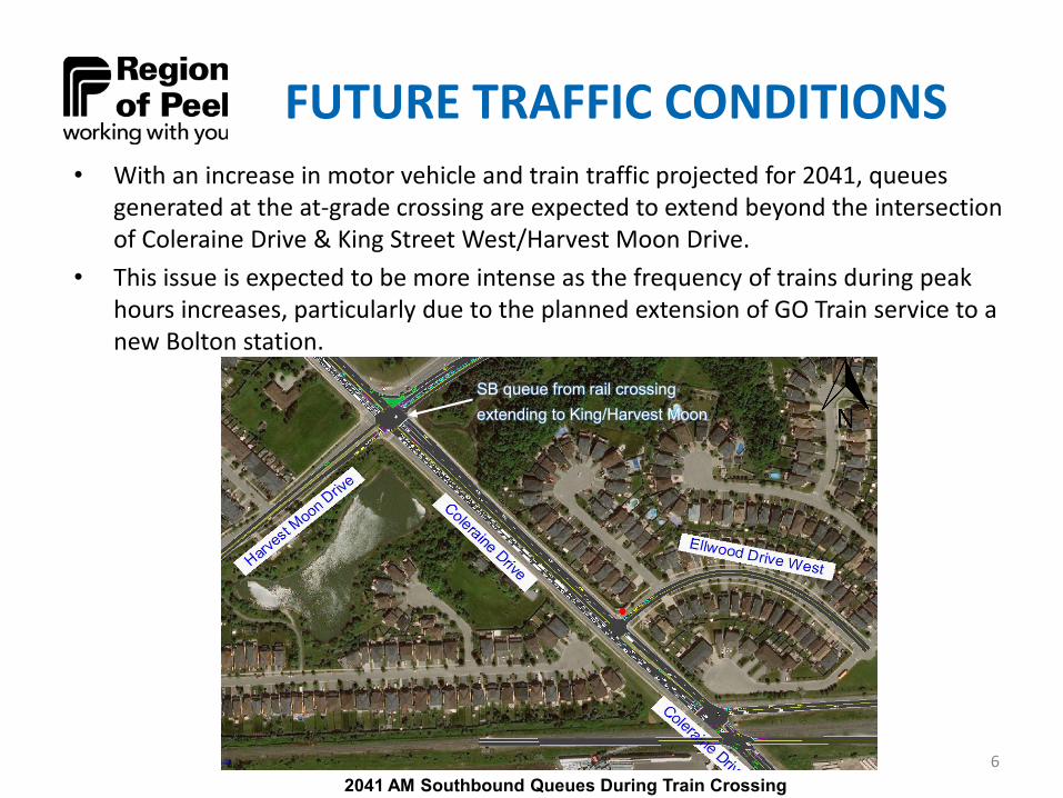
FUTURE TRAFFIC CONDITIONS• With an increase in motor vehicle and train traffic projected for 2041, queues
generated at the at-grade crossing are expected to extend beyond the intersection of Coleraine Drive & King Street West/Harvest Moon Drive.
• This issue is expected to be more intense as the frequency of trains during peak hours increases, particularly due to the planned extension of GO Train service to a new Bolton station.
SB queue from rail crossing extending to King/Harvest Moon
2041 AM Southbound Queues During Train Crossing6

FUTURE TRAFFIC CONDITIONS
Road Section Direction2017 Volumes
(vph)2041 Volumes
(vph)AM PM AM PM
Coleraine Drive south of King Street W
NB 249 1,070 349 1,500
SB 933 336 1,824 657
King Street W between Coleraine Drive and Station Road
EB 294 433 486 716
WB 422 338 982 787
7

ACTIVE TRANSPORTATIONLeft: Bolton Transportation Master Plan identifies a proposed buffered bicycle lane along King Street and Coleraine Drive.
Right: The proposed long-termRegional cycling network indicatesthat bicycle lanes are plannedalong King Street. This includesEmil Kolb Parkway, which is adirect continuation of ColeraineDrive north of King Street West. 8

EXISTING CONDITIONS PLAN
SEE ROLL PLAN
9

ENVIRONMENTAL INVENTORIESThe following environmental inventories are being completed as part of this study:
• Natural Environment Assessment• Drainage and Stormwater Management• Stage 1 Archaeological Assessment• Cultural and Built Heritage Assessment• Hydrogeological Investigation• Geotechnical Investigation and Pavement Design• Noise Impact• Air Quality Assessment• Contaminated Soils Assessment• Culvert Inspections• Meander Belt and Fluvial Geomorphology Analysis
10

NATURAL ENVIRONMENT • The project is located within the Humber River watershed.• A small tributary of the Humber River originates at a
stormwater pond on the west side of Coleraine Drive, north of the rail line, and flows under the road towards the east.
• TRCA identifies the valley along the watercourse as part of the Natural Heritage System, comprised of meadow and forest.
• CIMA field investigations did not find any rare species of flora or fauna; most of the species encountered were urban tolerant, and/or non-native species.
• Fish habitat is limited to the tributary east of Coleraine Drive, as the outlet of the stormwater pond is a barrier to fish.
• There are no natural features of provincial significance in the study area.
• There are no Core Areas of the Region of Peel Greenlands System in the study area, but the valley of the watercourse is considered an Environmental Policy Area in the Town of Caledon Official Plan.
11
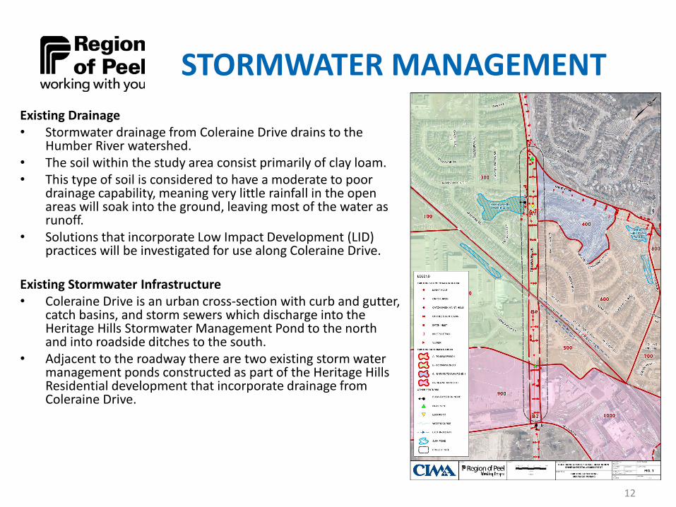
STORMWATER MANAGEMENTExisting Drainage• Stormwater drainage from Coleraine Drive drains to the
Humber River watershed.• The soil within the study area consist primarily of clay loam. • This type of soil is considered to have a moderate to poor
drainage capability, meaning very little rainfall in the open areas will soak into the ground, leaving most of the water as runoff.
• Solutions that incorporate Low Impact Development (LID) practices will be investigated for use along Coleraine Drive.
Existing Stormwater Infrastructure• Coleraine Drive is an urban cross-section with curb and gutter,
catch basins, and storm sewers which discharge into the Heritage Hills Stormwater Management Pond to the north and into roadside ditches to the south.
• Adjacent to the roadway there are two existing storm water management ponds constructed as part of the Heritage Hills Residential development that incorporate drainage from Coleraine Drive.
12
STAGE 1 ARCHAEOLOGICAL ASSESSMENT
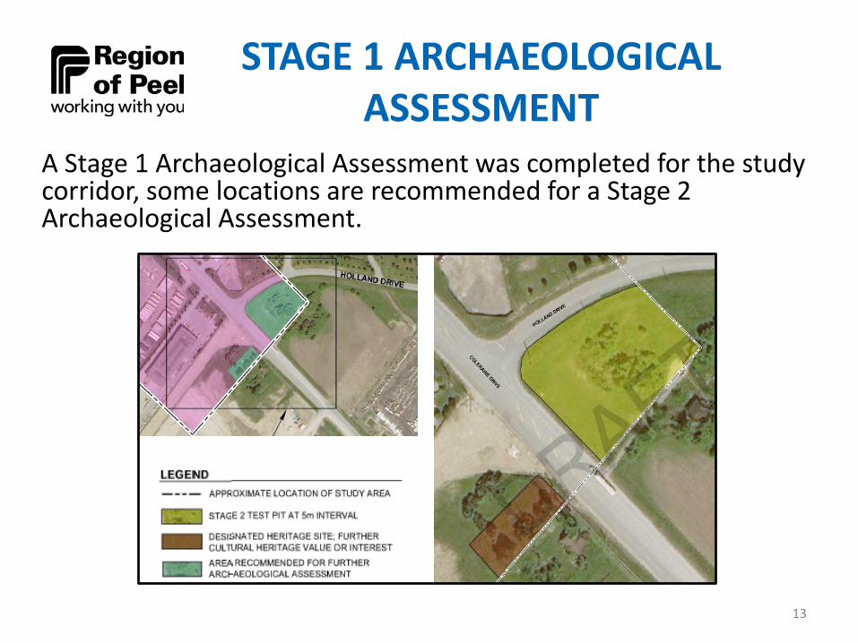
A Stage 1 Archaeological Assessment was completed for the study corridor, some locations are recommended for a Stage 2 Archaeological Assessment.
13
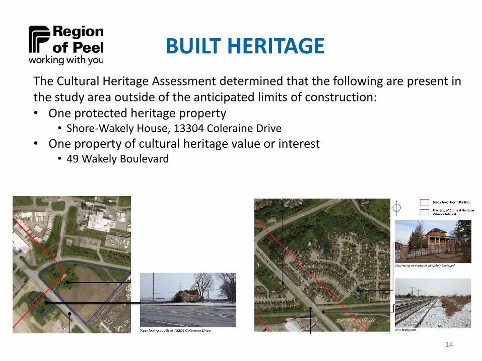
BUILT HERITAGEThe Cultural Heritage Assessment determined that the following are present in the study area outside of the anticipated limits of construction:• One protected heritage property
• Shore-Wakely House, 13304 Coleraine Drive• One property of cultural heritage value or interest
• 49 Wakely Boulevard
14
PROBLEM AND OPPORTUNITY STATEMENT
It is a Council priority to improve the efficiency in which goods move within and through Peel in order to manage congestion and enhance Peel’s economic competitiveness. The Goods Movements Strategic Plan (2012-2016) was developed and identified Coleraine Drive as a critical crossing that should be prioritized for grade separation.
An increase in motor vehicle and train traffic is projected for 2041 which is expected to result in queues generated at the at-grade crossing extending beyond the intersection of Coleraine Drive & King Street West/Harvest Moon Drive.
This issue is expected to worsen as the frequency of trains during peak hours increases, particularly due to the planned extension of GO Train service to a new Bolton station.
15
ALTERNATIVE PLANNING SOLUTIONS
Three alternative planning solutions were developed to address the problem statement:
1. Do Nothing
2. Change Grade of Rail2A) Raise rail over road, or 2B) Depress rail under road
3. Change Grade of Road3A) Raise road over rail, or 3B) Depress road under rail
16

(2A) Grade Separation: Raise Rail-over-Road Example
Highway 50, Palgrave ON17
Woodbridge Ave, Vaughan ON Regional Road 25, Milton ON
Parliament St, Toronto ON
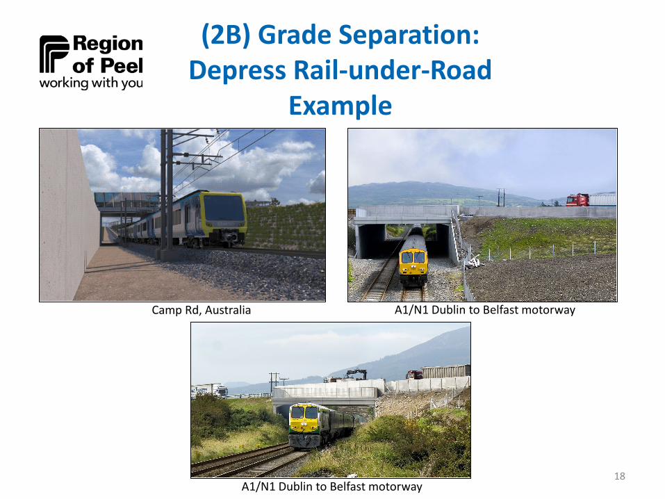
(2B) Grade Separation: Depress Rail-under-Road
Example
Camp Rd, Australia
A1/N1 Dublin to Belfast motorway
A1/N1 Dublin to Belfast motorway
18

(3A) Grade Separation: Raise Road-over-Rail Example
Norwood Junction, Croydon, United Kingdom Highway 50, Caledon ON
Chinguacousy Rd, Brampton ON19

(3B) Grade Separation: Depress Road-under-Rail
Example
Guelph Line, Burlington ON20
Cawthra Rd, Mississauga ON Derry Rd, Mississauga ON
Creditview Rd, Brampton ON
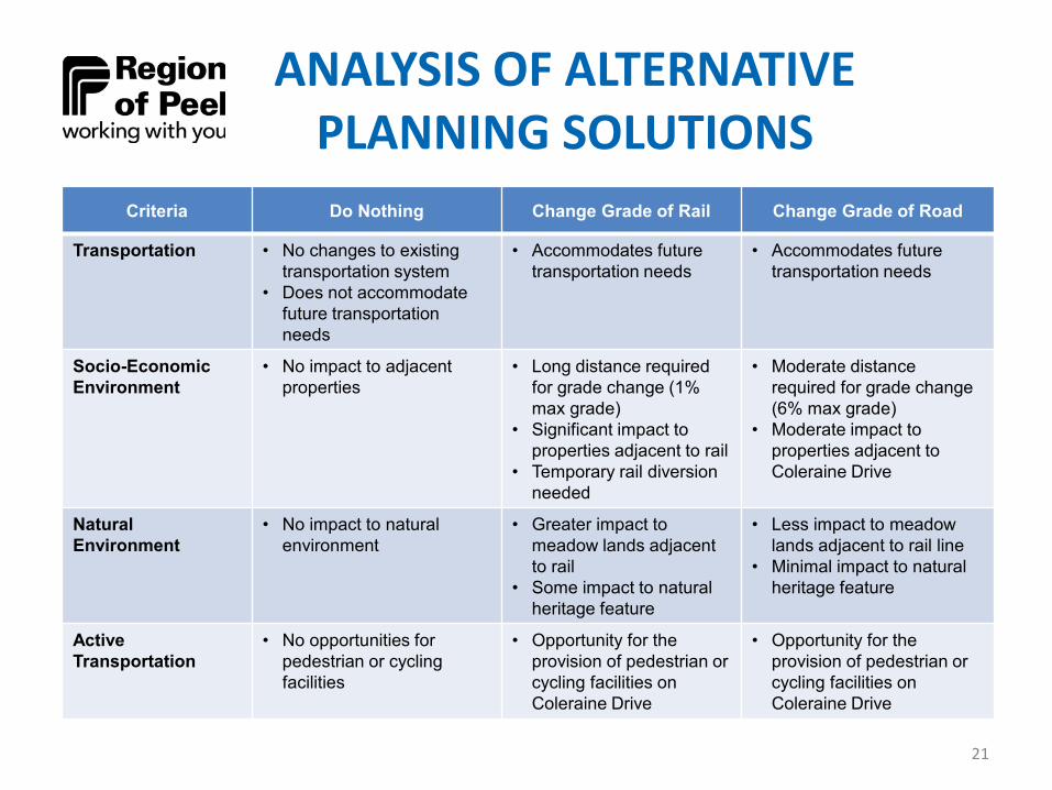
ANALYSIS OF ALTERNATIVE PLANNING SOLUTIONS
Criteria Do Nothing Change Grade of Rail Change Grade of Road
Transportation • No changes to existing transportation system
• Does not accommodate future transportation needs
• Accommodates future transportation needs
• Accommodates future transportation needs
Socio-EconomicEnvironment
• No impact to adjacent properties
• Long distance required for grade change (1% max grade)
• Significant impact to properties adjacent to rail
• Temporary rail diversion needed
• Moderate distance required for grade change (6% max grade)
• Moderate impact to properties adjacent to Coleraine Drive
Natural Environment
• No impact to natural environment
• Greater impact to meadow lands adjacent to rail
• Some impact to natural heritage feature
• Less impact to meadow lands adjacent to rail line
• Minimal impact to natural heritage feature
ActiveTransportation
• No opportunities for pedestrian or cycling facilities
• Opportunity for the provision of pedestrian or cycling facilities on Coleraine Drive
• Opportunity for the provision of pedestrian or cycling facilities on Coleraine Drive
21

PRELIMINARY PREFERREDSOLUTION
The preliminary preferred solution is to change the grade of the road on Coleraine Drive which will address the problem statement developed for the Coleraine Drive study area and is in support of the Region’s Long Range Transportation Plan and Goods Movement Strategic Plan endorsed by Region of Peel Council.
This preliminary recommended solution will consider the following:• Change grade of the road
• Depress road-under-rail grade separation; OR• Raise road-over-rail grade separation
• Provision of pedestrian and bicycle facilities along Coleraine Drive
22
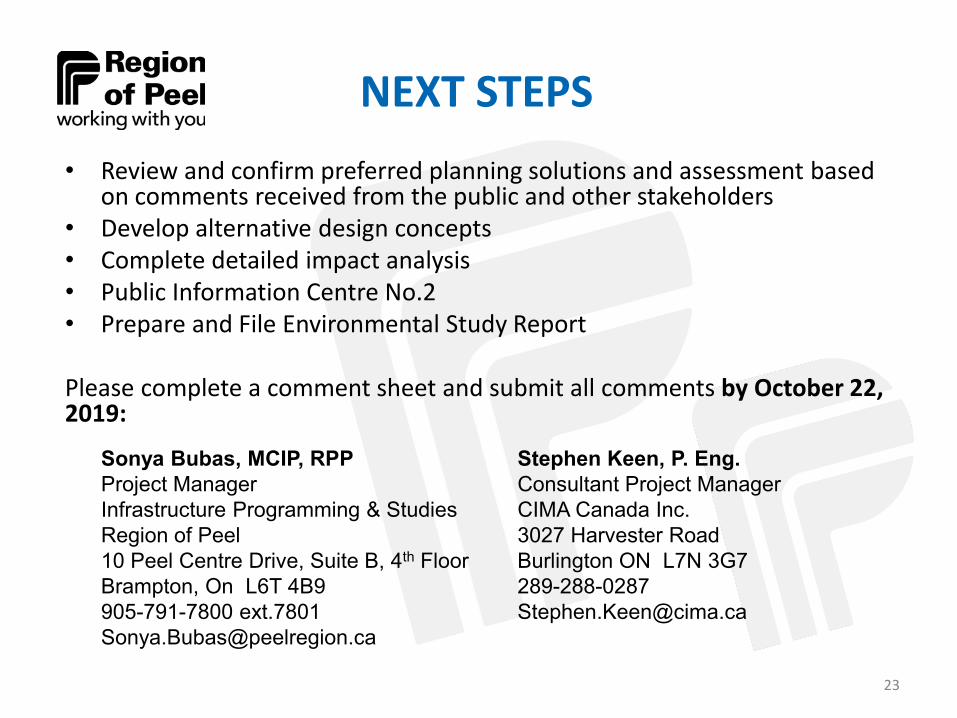
NEXT STEPS• Review and confirm preferred planning solutions and assessment based
on comments received from the public and other stakeholders • Develop alternative design concepts• Complete detailed impact analysis• Public Information Centre No.2• Prepare and File Environmental Study Report
Please complete a comment sheet and submit all comments by October 22, 2019:
Sonya Bubas, MCIP, RPPProject ManagerInfrastructure Programming & StudiesRegion of Peel10 Peel Centre Drive, Suite B, 4th FloorBrampton, On L6T 4B9905-791-7800 [email protected]
Stephen Keen, P. Eng. Consultant Project ManagerCIMA Canada Inc.3027 Harvester RoadBurlington ON L7N [email protected]
23