Public Briefing Forum - kalamunda.wa.gov.au · Consideration of Feasibility Investigation - Wattle...
72
Public Agenda Briefing Forum - 10 July 2018 Public Briefing Forum Minutes for 10 July 2018 UNCONFIRMED
-
Upload
duongduong -
Category
Documents
-
view
224 -
download
0
Transcript of Public Briefing Forum - kalamunda.wa.gov.au · Consideration of Feasibility Investigation - Wattle...
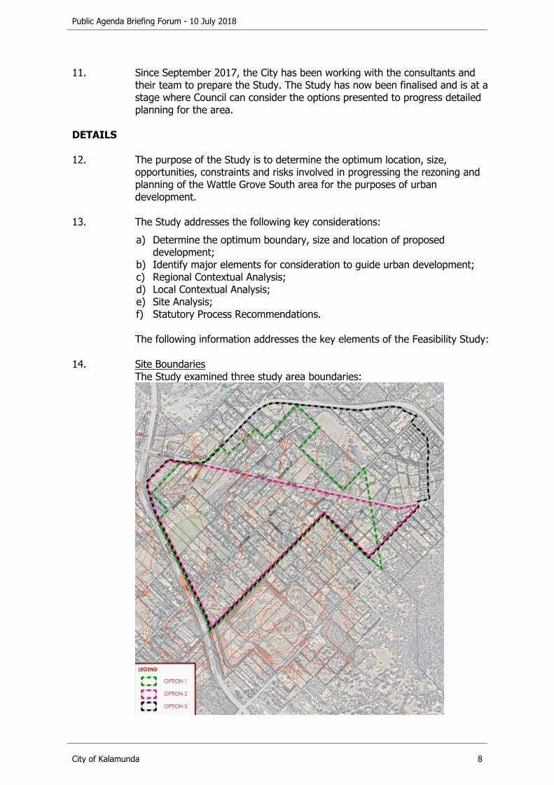
Public Agenda Briefing Forum - 10 July 2018
Public Briefing ForumMinutes for 10 July 2018UNCONFIRMED

Public Agenda Briefing Forum - 10 July 2018
City of Kalamunda 2
INDEX
1. Official Opening..............................................................................................................32. Attendance, Apologies and Leave of Absence ................................................................33. Declarations of Interest .................................................................................................44. Announcements by the Member Presiding Without Discussion.....................................45. Public Question Time......................................................................................................46. Public Statement Time ...................................................................................................47. Public Submissions Received in Writing ........................................................................58. Petitions Received..........................................................................................................59. Confidential Items Announced But Not Discussed.........................................................510. Reports to Council ..........................................................................................................6
10.1. Development Services Reports ............................................................................610.1.1. Consideration of Feasibility Investigation - Wattle Grove South...................................610.1.2. Lot 33 (332) Hale Road - Proposed Change of Use Shop to Restaurant and Use Not
Listed (Small Bar)..................................................................................................2710.2. Asset Services Reports.......................................................................................37
10.2.1. Drainage Asset Management Plan 2018 ..................................................................3710.3. Corporate Services Reports ...............................................................................43
10.3.1. Proposed Permanent Road Closure - Portions of Setosa Drive, Forrestfield ................4310.4. Office of the CEO Reports ..................................................................................49
10.4.1. Stirk Park Master Plan -Result of Public Comment on Inclusion of a Skate Park ..........4910.4.2. Maida Vale Reserve Master Plan .............................................................................5610.4.3. Ray Owen Sports Centre - Proposed Court Redevelopment Review ...........................65
11. Closure..........................................................................................................................72
Public Agenda Briefing Forum - 10 July 2018
City of Kalamunda 3
1. Official Opening
The Presiding Member opened the meeting at 6:30pm and welcomed Councillors, Staff and Members of the Public Gallery.
2. Attendance, Apologies and Leave of Absence
CouncillorsSouth East Ward Michael FernieGeoff Stallard (Presiding Member)South West WardLesley BoydAllan MortonBrooke O’DonnellNorth West WardDavid AlmondSara LohmeyerDylan O'ConnorNorth WardCameron BlairTracy Destree (left at 7:55pm)
Members of StaffChief Executive OfficerRhonda HardyExecutive TeamGary Ticehurst - Director Corporate ServicesDennis Blair - Director Asset ServicesPeter Varelis - Director Development ServicesSimon Di Rosso - General Counsel & Executive AdvisorManagement TeamAndrew Fowler-Tutt - Manager Approval Services (left at 7:15pm)Doug Bartlett - Manager Asset Planning & ManagementRaymond Dong - Manager Strategic Planning (left at 7:15pm)Kevin O'Connor - Coordinator Recreation Facilities & ServicesAdministration SupportKristy Lisle - Legal & Governance Assistant to General Donna McPherson - Executive Research Officer to Chief Executive OfficerSami Anderson - Cloud Service Officer
Members of the Public 12.
Members of the Press Nil.
Apologies South East Ward Cr John Giardina - (Mayor)
Leave of Absence Previously ApprovedNorth WardCr Margaret Thomas

Public Agenda Briefing Forum - 10 July 2018
City of Kalamunda 4
3. Declarations of Interest
3.1. Disclosure of Financial and Proximity Interestsa. Members must disclose the nature of their interest in matter to be discussed at
the meeting. (Section 5.56 of the Local Government Act 1995.)
b. Employees must disclose the nature of their interest in reports or advice when giving the report or advice to the meeting. (Section 5.70 of the Local Government Act 1995.)
3.1.1 Nil.
3.2. Disclosure of Interest Affecting Impartialitya. Members and staff must disclose their interest in matters to be discussed at
the meeting in respect of which the member or employee had given or will give advice.
3.2.1 Nil.
4. Announcements by the Member Presiding Without Discussion
4.1 Nil.
5. Public Question Time
Public question time will be allocated a maximum of 10 minutes and will be limited to two (2) minutes per member of the public, with a limit of two (2) verbal questions per member of the public.
Statements are not to precede the asking of a question during public question time. Statements should be made during public submissions.
For the purposes of Minuting, these questions and answers will be summarised.
5.1 Nil.
6. Public Statement Time
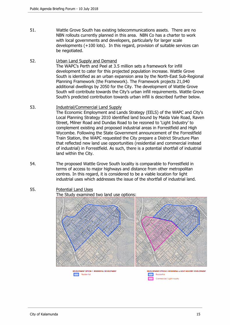
A period of maximum 10 minutes is provided to allow public statements from the gallery on matters relating to a matter contained on the agenda or the functions of Council. Public Statement Time will be limited to two (2) minutes per member of the public.
Public Statement Time is declared closed following the 10 minute allocated time period, or earlier if there are no further statements.
For the purposes of Minuting, these statements will be summarised.
6.1 Nil.
Public Agenda Briefing Forum - 10 July 2018
City of Kalamunda 5
7. Public Submissions Received in Writing
7.1 Nil.
8. Petitions Received
8.1 Nil.
9. Confidential Items Announced But Not Discussed
9.1 Item 10.4.1 Stirk Park Master Plan – Attachment 2.Local Government Act 1995 (WA) Section 5.23 (2) (b) - "the personal affairs of any person."

Public Agenda Briefing Forum - 10 July 2018
City of Kalamunda 6
10. Reports to Council
10.1. Development Services Reports
10.1.1. Consideration of Feasibility Investigation - Wattle Grove South
Mr Dick Lovegrove of 41 Brentwood Road, Wattle Grove spoke in favour of the recommendation. The Manager Strategic Planning provided a presentation on this item. Questions were asked by Councillors and were clarified. No questions were asked by the public.
Declaration of financial / conflict of interests to be recorded prior to dealing with each item.
Previous Items NilDirectorate Development ServicesBusiness Unit Strategic Planning File Reference PG-MRS-024Applicant City of KalamundaOwner N/A
Attachments 1. City of Kalamunda - Feasibility Investigation - Wattle Grove [10.1.1.1]
EXECUTIVE SUMMARY
1. The purpose of this report is to provide Council with the opportunity to consider the options and recommendations presented by the Wattle Grove South Feasibility Study (the Study) to initiate detailed planning for the Wattle Grove South area.
2. The Feasibility Study presents three boundary options, two land use options and two statutory process options to progress the detailed planning for the area.
3. It is recommended that Council accepts Boundary Option 3, Land Use Option 2 and Statutory Process Option 2 as presented in the Study for the purposes of proceeding with detailed planning for Wattle Grove South.
BACKGROUND
4. Land Details:Land Area: 310ha
Local Planning Scheme Zone: Special Rural
Metropolitan Regional Scheme Zone: Rural

Public Agenda Briefing Forum - 10 July 2018
City of Kalamunda 7
5. Locality Plan:
6. The Study Area is located within the City of Kalamunda (the City) in the suburb of Wattle Grove and is generally bound by Tonkin Highway to the west, Welshpool Road East to the north, and Kelvin Road, Judith Road, Fontano Road and the City's border with the City of Gosnells to the east.
7. The City's Local Planning Strategy 2010 identifies Wattle Grove as an urban investigation area.
8. The Western Australian Planning Commission's (WAPC) North-East Sub-Regional Planning Framework (the Framework), adopted in March 2018, identifies the majority of Wattle Grove South as Urban Expansion. An eastern portion of Wattle Grove South is identified as Urban Investigation.
9. The Framework specifies the following key considerations for the 'Urban Investigation' land:a) Geotechnical analysis/land suitability to provide connections to reticulated
wastewater services;b) Bushfire risk;c) Protection of significant environmental attributes.
10. In September 2017 the City appointed consultants to undertake the Study.
Public Agenda Briefing Forum - 10 July 2018
City of Kalamunda 8
11. Since September 2017, the City has been working with the consultants and their team to prepare the Study. The Study has now been finalised and is at a stage where Council can consider the options presented to progress detailed planning for the area.
DETAILS
12. The purpose of the Study is to determine the optimum location, size, opportunities, constraints and risks involved in progressing the rezoning and planning of the Wattle Grove South area for the purposes of urban development.
13. The Study addresses the following key considerations:a) Determine the optimum boundary, size and location of proposed
development;b) Identify major elements for consideration to guide urban development;c) Regional Contextual Analysis;d) Local Contextual Analysis;e) Site Analysis;f) Statutory Process Recommendations.
The following information addresses the key elements of the Feasibility Study:
14. Site BoundariesThe Study examined three study area boundaries:
Public Agenda Briefing Forum - 10 July 2018
City of Kalamunda 9
15. Option 1 (Green boundary): Boundary as shown on the draft North East Sub-regional Planning Framework.a) The site has a total land area of approximately 209ha; b) The ‘Urban Expansion’ boundary shown on the draft North East Sub-
regional Planning Framework was illogical and traversed a number of lots, rather than following specific lot boundaries;
c) It is unclear why certain lots were excluded from the ‘Urban Expansion’ area and why the WAPC determined that the eastern boundary of the area should follow the existing powerline easement.
16. Option 2 (Pink boundary): Reduce the ‘Urban Expansion’ area to include only the land south of Crystal Brook Road. a) The site has a total land area of approximately 162ha;b) This option was conceived to create a more logical northern boundary for
the study area, being Crystal Brook Road, as opposed to the illogical boundary identified in the draft Framework;
c) This option is not considered to be the optimum outcome for the City nor for those landowners for land identified as ‘Urban Expansion’ under the draft North East Sub-regional Planning Framework located on the north side of Crystal Brook Road;
d) Under this approach, a separate planning process will be required, at a future time, to pursue any development of the northern area.
17. Option 3 (Black boundary): Extension of the ‘Urban Expansion’ boundary to Fontano Road and Judith Road (eastern boundary), Welshpool Road (northern boundary), and towards the intersection of Tonkin Highway/Welshpool Road East (western boundary). a) The site has a total land area of approximately 310ha;b) The proposed boundary is logical as it is bound by existing roads and is
informed by the topographical and environmental characteristics of the site;
c) Extending the boundary in this way would also ensure there are no small rural pockets of land excluded from the rezoning for no logical reason;
d) The timing of development of the eastern most part of the study area is anticipated to be longer term, however, the notion of residential development being ultimately bound by the Scarp is logical;
e) The proposed boundary is consistent with the City’s Local Planning Strategy ‘Investigation Area’ and the recently adopted final North-East Sub-regional Planning Framework.
18. Option 3 is considered to be the optimal study area boundary. The final North East Sub-regional Planning Framework was released on 23 March 2018. ThisFramework amends the ‘Urban Expansion’ boundary to the extent that it essentially aligns with Option 3 confirming the suitability of this adopted study area boundary.

Public Agenda Briefing Forum - 10 July 2018
City of Kalamunda 10
19. Surrounding Land Use and DevelopmentThe subject site is situated within close proximity to established and future residential, commercial, Public Open Space (POS) areas and services including:a) Residential development within the suburb of Forrestfield, located
approximately 2km north of the subject site;b) Beckenham Train Station located approximately 4.5km south west of the
subject site;c) Westfield Carousel located approximately 5km south west of the subject
site;d) Hartfield Park Recreation Centre located approximately 700m north;e) Lesmurdie National Park located 1.2km to the north east;f) The site is located approximately 6km south of the future Forrestfield
Train Station.
20. Development of the site represents the most efficient use of the land given the subject land’s strategic location in close proximity to the abovementioned land uses, capitalising from existing infrastructure and services, the future Forrestfield Train Station and nearby major arterial routes (eg. Tonkin Highway and Roe Highway).
21. The subject land abuts the City of Gosnells Maddington Kenwick Strategic Employment Area (MKSEA) a future general industrial/business area. The detailed planning of Wattle Grove South needs to consider how to appropriately address the interface with MKSEA.
22. EnvironmentalA desktop review by the environmental consultants identified that remnant vegetation has potential black cockatoo habitat and Forrestfield Complex, which has less than 30% remaining.
23. There are a number of Environmentally Sensitive Areas (ESA) mapped within and adjacent to the current study area. These ESA are associated with known occurrences of threatened / priority flora that occur within and adjacent to the site.
24. The following Declared Rare Flora (DRF) or Threatened Ecological Community has been identified across the site:a) Conospermum undulatum (Wavy Leaved Smokebush);b) Isopogon drummondii;c) Banksia mimica (Summer Honeypot);d) Lasiopetalum glutinosum subsp. Glutinosum;e) Thelymitra magnifica (Crystal Brook Sun Orchid).
25. Given the above, site specific flora and vegetation surveys would be required to confirm the presence or absence of these DRF species which would provide a better indication of the land available for development and where future POS areas should be located. Flora and fauna investigations will be required at subsequent stages of the planning and rezoning process.
Public Agenda Briefing Forum - 10 July 2018
City of Kalamunda 11
26. The desktop review has also identified that Bush Forever Site 50, which occurs north of Welshpool Road is mapped as an ESA and includes a 500m buffer that covers a significant portion of the area. This element will require further investigation during more detailed phases of the planning process.
27. Another key environmental consideration is Crystal Brook, which transects the northern portion of study area. Any future development will need to consider appropriate foreshore setbacks, reservation and future management requirements, together with stormwater management and water quality control.
28. Whilst there are a number of key environmental constraints associated with broadening the study area, it may lead to the following significant environmental outcomes for the City and broader community:a) Provide the City with an opportunity to identify and prioritise these natural
assets for future conservation and protection in the long-term, as opposed to leaving these areas in private ownership;
b) Developing and implementing various town planning mechanisms, through scheme provisions and future structure plans that will allow for these areas to be acquired, set aside for conservation and appropriately managed;
c) Acknowledging that future urbanisation/intensification of land uses in the current study area will inevitably lead to increased pressure and edge effects on these natural areas if left unmanaged. Inclusion of the broader area can lead to these natural areas also being appropriately managed to ensure potential impacts from future urbanisation are minimised. This can be done through future environmental management plans, community education and/or funding being allocated to provide controlled access and rehabilitation where required.
29. Aboriginal HeritageA desktop search has identified two Registered Aboriginal Heritage Sites and one Lodged Aboriginal Heritage Site intersecting the Site, and these are: a) Brentwood Road Swamp (No.4343);b) Brentwood Road Quarry (No.342);c) Brentwood Road NW (No.4341).
30. These sites will require further consideration through more detailed phases of the planning process and be managed as part of any future POS or other future reservation.
31. Land Use BuffersThe site is constrained by generic or imposed buffers on prescribed premises (poultry farms, turf farm and kennels). The opportunity for land development within the site is recommended to be split into two separate land uses. The area to the south of Crystal Brook Road may be more suitable for light industrial development. The area to the north of Crystal Brook Road has the potential to be developed for residential uses. The proposed light industrial uses create a suitable interface between existing uses and future urban areas.
Public Agenda Briefing Forum - 10 July 2018
City of Kalamunda 12
Future more detailed studies will address potential buffer issues as more specific land uses and the urban / industrial layout of the area is progressed and defined.
32. HydrologyThere are several tributaries which traverse the site, as well as a wetland located along the western boundary. A District Water Management Strategy (DWMS) will be required as part of the future District Structure Plan, as well as groundwater monitoring to inform the Local Water Management Strategy (LWMS) and detailed local structure planning process.
33. The key objective of the DWMS will be to demonstrate that the land is capable of supporting the change in land use and is able to achieve appropriate urban water management outcomes.
34. It is recommended that following the Council’s decision on the final boundary of the study area, and prior to the MRS Amendment being initiated, a District Structure Plan will need to be prepared with a supporting DWMS being submitted to the Department of Water and Environmental Regulation for approval.
35. GroundwaterData from the Perth Groundwater Map indicates the groundwater table ranges between 12m Australian Height Datum (AHD) and 17m AHD. Groundwater flows from east to west. The area is not within a Public Drinking Water Source Area.
36. Surface WaterYule Brook, a major tributary, exists 55m to the north of the site, separated by Welshpool Road East. An un-named minor non-perennial watercourse traverses the northern portion of the site connecting to Yule Brook in the northeast. In addition, another minor perennial watercourse traverses along the boundary in the south-western corner of the site. The site also contains three constructed earth dams and two perennial lakes. A constructed minordrain extends south of Crystal Brook Road to a constructed dam. The site is not within a mapped 100 Year ARI Floodplain Area.
37. Desktop mapping has identified that small portions along the western boundary of the site along Tonkin Highway are mapped as Conservation Category (CCW) and Resource Enhancement wetlands (REW). As such, there is the potential for their associated buffers to impinge on the south-western portion of the site. A buffer distance of 30 – 50m is generally imposed on REWs and a minimum 50m buffer is generally imposed on CCWs. However, as the vegetation within the mapped wetlands and the corresponding buffers does not appear to be intact and has been subject to clearing, it is likely that smaller buffer distances from the wetlands could be negotiated.
38. Alternatively, there is a potential opportunity to reclassify the wetlands within and surrounding the site to increase the developable potential of the site. Site specific surveys would be required to assess the vegetation remaining and the condition of the wetlands. A Wetland and Wetland Buffer Management Plan may be required at subdivision stage.

Public Agenda Briefing Forum - 10 July 2018
City of Kalamunda 13
39. Infrastructure and ServicingThe key existing road and movement features are summarised as follows: a) Access to the subject land is currently available via the existing roads of
Tonkin Highway (classified as a Primary Regional Road), Welshpool Road East (classified as an Other Regional Road) and Kelvin Road (classified as a local road).
40. The Study Area is reliant on some significant improvements to road connectivity, with consideration needed for the impact of the proposed Welshpool Road East grade separation on the development potential in the western third of the Study Area. Any bridge over the Tonkin Highway will have the following minimum requirements: a) Min depth of bridge structure = 1.7 metres;b) Min clearance to Tonkin Highway carriageways = 6.5 metres.
41. The cost of the bridge may need to be discussed with the State Government as Main Roads WA may not necessarily take the responsibility of the bridge.
42. Existing Traffic Counts:a) Tonkin Highway (South of Welshpool Road East) carries approximately
47,882 vehicles per day;b) Welshpool Road East (East of Tonkin Highway) carries approximately
20,314 vehicles per day;c) Crystal Brook Road (250m east of Brentwood Road) carries approximately
2,168 vehicles per day.
43. Future development and ultimate trip generation would be subject to detailed proposals at Structure Plan or subdivision stages. A more detailed Transport Assessment of the proposed land uses using WAPC guidelines will need to be completed at the structure planning phase.
44. The Water Corporation has confirmed there are significant water assets which run adjacent to the area inclusive of the Canning Trunk Main, with the Canning Foothills Trunk Main branching off at Hale Road. It is considered that a network of local infrastructure can be planned pending detailed future development yields and road layouts at the Structure Planning stage.
45. The site forms part of a larger area that is planned to be established as a new sewer district in Water Corporation planning, called the Wattle Grove Sewer District. This district is bounded by Bickley Road to the south, Roe Highwayto the west, Welshpool Road to the north and the Mundy Regional Park to the east. Long term conceptual planning has been conducted by the Water Corporation with a general layout of infrastructure provided.
46. The current planning is based on the discharge of wastewater from the newly formed Wattle Grove Sewer District to be via a gravity feed to a 900mm diameter wastewater pipe running westward along Bickley Road.

Public Agenda Briefing Forum - 10 July 2018
City of Kalamunda 14
This collection sewer currently terminates at the intersection of Bickley Road and Dulwich Street, Beckenham, however this is a long-term ultimate design model.
47. None of these works will be required to commence development within Wattle Grove as the Water Corporation usually allow the development of interim scenarios utilising available capacities in existing systems. The key point with the allowance of this use of existing system capacities are that the design of the overall network must not prejudice the future ultimate network. Therefore, all designs developed will need to consider both the ultimate planning and interim availabilities, with developers who construct interim solutions understanding that the cost for those works will be borne solely by the developer.
48. Long term service planning by the Water Corporation is predicated on the development of the MKSEA area to the west and south-west of the site under investigation, however development has commenced in the MKSEA areawithout the construction of the ultimate sewer network reinforcing the points made above.
49. The following methodologies need to be considered and negotiated with Water Corporation:a) Enter into a Performance Agreement / Tanking Agreement
Where infrastructure assets are located a long distance from a potential development site, and where the planning for the development of the assets which will connect the site in the future are known and relatively risk-free for the Water Corporation, the Water Corporation can enter into agreements with developers for the tankering of early release stages to allow the developer to fund studies and the extension of infrastructure;
b) Developer Constructed Headworks Asset ProcessLandowners have the opportunity to construct works on behalf of the Water Corporation. The Water Corporation has a 5-year Capital Investment Programme (CIP), which is developed in consultation with the land development industry to determine the required timing for major infrastructure. It is understood that the Water Corporation will generally fund wastewater infrastructure works of diameter 450mm or greater for gravity networks. Given the planned network shows a series of 450mm to 900mm-diameter pipes between Brentwood Road (south of Tonkin Highway) and the corner of Bickley Road and Brixton Road there is strong potential for these works being negotiated and agreed under the Water Corporation’s future Capital Works Program or being the subject of a detailed pre-fund arrangement;
c) Construction of a temporary Pumping StationDiscussions will be required with Water Corporation for the potential staging sections of the Wattle Grove district with a temporary or private pressure main and pumping station.
50. Existing power services are present nearby and extensions will be undertaken to service the subject land.
Public Agenda Briefing Forum - 10 July 2018
City of Kalamunda 15
51. Wattle Grove South has existing telecommunications assets. There are no NBN rollouts currently planned in this area. NBN Co has a charter to work with local governments and developers, particularly for larger scale developments (+100 lots). In this regard, provision of suitable services can be negotiated.
52. Urban Land Supply and DemandThe WAPC’s Perth and Peel at 3.5 million sets a framework for infill development to cater for this projected population increase. Wattle Grove South is identified as an urban expansion area by the North-East Sub-Regional Planning Framework (the Framework). The Framework projects 21,040 additional dwellings by 2050 for the City. The development of Wattle Grove South will contribute towards the City’s urban infill requirements. Wattle Grove South’s predicted contribution towards urban infill is described further below.
53. Industrial/Commercial Land SupplyThe Economic Employment and Lands Strategy (EELS) of the WAPC and City's Local Planning Strategy 2010 identified land bound by Maida Vale Road, Raven Street, Milner Road and Dundas Road to be rezoned to ‘Light Industry’ to complement existing and proposed industrial areas in Forrestfield and High Wycombe. Following the State Government announcement of the Forrestfield Train Station, the WAPC requested the City prepare a District Structure Plan that reflected new land use opportunities (residential and commercial instead of industrial) in Forrestfield. As such, there is a potential shortfall of industrial land within the City.
54. The proposed Wattle Grove South locality is comparable to Forrestfield in terms of access to major highways and distance from other metropolitan centres. In this regard, it is considered to be a viable location for light industrial uses which addresses the issue of the shortfall of industrial land.
55. Potential Land UsesThe Study examined two land use options:

Public Agenda Briefing Forum - 10 July 2018
City of Kalamunda 16
56. Option 1: Residential Development Under this option, the whole Wattle Grove South area would be concurrently zoned ‘Urban’ under the Metropolitan Region Scheme (MRS), and ‘Urban Development’ under the City of Kalamunda Local Planning Scheme No.3 (LPS3) and developed entirely for residential purposes.
57. The development potential of the subject land is calculated based on the following assumptions: a) Total land area (excludes existing roads): 292ha;b) 10% POS + 2.5% drainage: 36.5ha;c) 25% roads: 73ha;d) Total developable area: Total land area – (POS and Drainage + Roads) =
182.5ha.
58. The estimated population for the site based on Option 1 is as follows:a) Scenario 1 - Average of 15 lots to be developed per hectare and 2.6
persons per lot = i) 2,737.5 lots ii) 7,117.5 persons;
b) Scenario 2 – Average of 20 lots to be developed per hectare and 2.6 persons per lot =i) 3,650 lotsii) 9,490 persons;
c) Scenario 3 – Developable area to be subdivided at an average of 450m2 per lot and 2.6 persons per lot =i) 4,055.56 lots ii) 10,544.4 persons.
59. The total projected dwellings and population projections above are based on the assumption that the whole area will be residential. It does not exclude land required for a future commercial uses (neighbourhood centres), community facilities, or any schools (at least 1 primary school site will be required). It also assumes only 10% POS. More land for recreation and conservation may be required pending further environmental analysis.
60. Option 1 is consistent with the North-East Sub-regional Planning Framework; however the ‘Medium-Long Term (2022+)’ timeframe set out the Frameworks may delay the initiation of an MRS Amendment. Officers of the Department of Planning, Lands & Heritage have indicated that this land may not be suitable for development (given the availability of other zoned land within the Perth Metropolitan Region), until beyond 2022.
61. The Department of Education in 2015 indicated the following:a) Primary school sites are provided based on the standard requirement of
one site per 1,500-1,800 dwellings for government schools (thus likely two schools required);
b) The future school sites would ideally be centrally located to each catchment (potentially one north and one south of Crystal Brook Road);
c) No high school site is required due to the study areas being under the population threshold requirement as well as the proximity to Darling Range College.
Public Agenda Briefing Forum - 10 July 2018
City of Kalamunda 17
School site requirements will need to be reviewed in conjunction with the Department of Education during detailed planning.
62. Option 2: Residential and Industrial DevelopmentUnder this option, two separate MRS amendments would be submitted, one for the land generally north of Crystal Brook Road, and one for land south of Crystal Brook Road. The MRS amendments will seek concurrent amendments to rezone the land to ‘Urban Development’ and/or ‘Industrial Development’ under the Local Planning Scheme.
63. The development potential of the subject land is calculated based on the following assumptions with residential development being located north of Crystal Brook Road: a) Total land area (excludes existing roads): 292ha;b) Total residential zoned area: 156ha;c) 10% POS + 2.5% drainage: 19.5ha;d) 25% roads: 39ha;e) Total developable area: Residential Area – (POS and Drainage + Roads) =
97.5ha.
64. The estimated population for the site based on Option 2 is as follows:a) Scenario 1 - Average of 15 lots to be developed per hectare and 2.6
persons per lot =i) 1,462.5 lotsii) 3,802.5 persons;
b) Scenario 2 – Average of 20 lots to be developed per hectare and 2.6 persons per lot =i) 1,950 lots ii) 5,070 persons;
c) Scenario 3 – Developable area to be subdivided at an average of 450m2 per lot and 2.6 persons per lot =i) 2,166.67 lotsii) 4,333.33 persons.
65. As mentioned previously, the City lost a significant area of future industrial land through the development of a large portion of Forrestfield North for residential purposes. This land was well located adjacent to the Perth Airport, marshalling yards and local highways. There is limited opportunity in other areas of the City for industrial land uses with such a high level of access to services and transport. The City also has limited bulky good/mixed business land use opportunities. The portion of Wattle Grove South to the south of Crystal Brook Road is of a suitable size to provide for a strategic industrial/bulky good/mixed business area.
66. Wattle Grove South is very well located, being in close proximity to: a) Perth CBD;b) Perth airport;c) Forrestfield marshalling yards;

Public Agenda Briefing Forum - 10 July 2018
City of Kalamunda 18
d) Abutting highways;e) Services and infrastructure.
67. The land use exposure provided by Tonkin Highway is also a key opportunity for light industrial development.
68. Located abutting a major highway and high capacity gas pipeline, being impacted by a poultry farm buffer and being situated in close proximity to services and infrastructure, confirms that the use of the land for light industrial purposes represents an ideal integration with surrounding development.
69. Crystal Brook Road also provides an ideal northern boundary to the industrial precinct, creating a physical buffer between this land use and the future residential development area to the north.
70. It is envisioned that land generally south of Crystal Brook Road will be designated as commercial/light industry zone under the Structure Plan. Whilst land generally north of Crystal Brook Road will be designated for residential development. Option 2 is the recommended option.
71. Statutory ProcessThe Study examined two Statutory Process or rezoning options:
72. Scenario 1: Urban Development ZonePrepare two separate MRS amendments, one for the residential area generally north of Crystal Brook Road and one for the commercial/light industrial area south of Crystal Brook Road. Both MRS Amendments will rezone the subject land from the ‘Rural’ zone to ‘Urban’ zone with a concurrent amendment to the City’s Local Planning Scheme No.3 (LPS3) to rezone the land from ‘Special Rural’ to ‘Urban Development’.
73. Separate MRS amendment requests are proposed given the feedback received from the DPLH that the ‘medium-long term (2022+)’ timeframe for residential development will likely delay the initiation, advertising and consideration of the MRS amendment. It is expected that separate amendment processes will ensure that the commercial/light industrial area is not delayed by the ‘medium-long term (2022+)’ residential timeframe advised by DPLH.
74. Scenario 2: Urban and Industrial Development Zones Prepare two separate MRS amendments, one for the residential area generally north of Crystal Brook Road and one for the commercial/light industrial area south of Crystal Brook Road.
75. The first MRS Amendment will seek to rezone the southern portion of the study area from the ‘Rural’ zone to ‘Urban’ zone, and a concurrent local scheme amendment for land generally south of Crystal Brook Road to ‘Industrial Development’.
76. Although the intention is for the site to the South of Crystal Brook Road to be industrial, the light industrial land uses can be applied to an Urban MRS zoning. An example of this is in the Forrestfield/High Wycombe Industrial Area Stage 1.
Public Agenda Briefing Forum - 10 July 2018
City of Kalamunda 19
77. The second Metropolitan Region Scheme (MRS) amendment will seek to rezone a portion of the study area from the ‘Rural’ zone to ‘Urban’ zone, and request a concurrent local scheme amendment to rezone land generally north of Crystal Brook Road from ‘Special Rural’ and ‘Rural’ to ‘Urban Development’.
78. Under LPS3 separate development zones are proposed to give the WAPC and the City increased certainty that the land generally south of Crystal Brook Road will be developed for light industrial/commercial uses, as recommended. The ‘Industrial Development’ zone will provide for orderly and proper planning through the preparation and adoption of a Structure Plan, and allow the City to consider uses in accordance with LPS3. The ultimate preparation of a structure plan and creation of a new zone (through a local planning scheme amendment process) for this area will ensure that heavy and general industrial uses are not permitted.
79. The ‘Urban Development’ zone will also require the preparation and adoption of a Structure Plan over the proposed residential area. This Structure Plan will facilitate the ultimate subdivision and/or development of land for residential purposes and for commercial and other uses normally associated with residential development.
80. A Scheme Amendment will also need to be prepared to designate the land on the scheme map as a ‘Development Contribution Area’ and include the area in Schedule 12 – Development Contribution Areas in order to facilitate the creation of a Development Contribution Plan for the area to coordinate infrastructure delivery.
81. Technical StudiesThe following reports/studies will be required to support the rezoning of the site to 'Urban' under the MRS and to 'Urban Development'/'Industrial Development' under LPS3. They will also support the preparation of the strategic District Structure Plan which will include: a) Environmental Assessment (including Spring Flora and Fauna Survey);b) District or local water management strategy (groundwater monitoring for
two winters);c) Bushfire hazard assessment and management plans;d) Civil Engineering;e) Traffic Engineering;f) Acoustic Assessment;g) Economic/Retail Strategy.
STATUTORY AND LEGAL CONSIDERATIONS
82. If Council accepts to proceed with abovementioned proposed scenarios, the Planning and Development Act 2005 (the Act) establishes procedures relating the amendments to the MRS. If the WAPC initiates the proposed amendment(s), then ultimately the amendment(s) will be determined by the Minister for Planning.
Public Agenda Briefing Forum - 10 July 2018
City of Kalamunda 20
83. The Act allows for amendments to the MRS to be processed as either 'minor' or 'major' depending on whether they are considered to constitute a substantial alteration to the MRS or not. Whether to lodge the amendment(s) as minor or major will be determined during the preparation of the MRS amendment(s) documentation and in consultation with the DPLH.
84. If Council accepts to proceed with the abovementioned proposed scenarios, the Planning and Development Act (Local Planning Schemes) Regulations 2015 (the Regulations) establishes procedures relating the amendments to the LPS3. If the City initiates the amendment(s), then ultimately the amendment(s) will need to be approved by Council and then determined by the Minster for Planning.
85. The new Planning Regulations allows for amendments to the LPS3 to be processed as either 'basic', 'standard' or 'complex' depending the significance of the alteration to the LPS3. It is likely that the amendment(s) will be processed as standard due to the following reasons listed under the Regulations:
a) 'An amendment that is consistent with a local planning strategy for the scheme that has been endorsed by the Commission;
b) An amendment to the scheme so that is consistent with a region planning scheme that applies to the scheme area, other than an amendment that is a basic amendment'
POLICY CONSIDERATIONS
86. Directions 2031 and Beyond Directions 2031 and Beyond is the State Government’s key strategic planning document which outlines the spatial framework for the future growth of Perth and Peel for the next twenty years.
87. Perth and Peel @ 3.5million - North-East Sub-Regional Planning Framework In March 2018, the WAPC released the final Perth and Peel @ 3.5 million suite of documents, including the Sub-Regional Frameworks. These documents identify how the vision set out in Directions 2031 for a City of 3.5 million people by 2050 can be realised.
88. The North-East Sub-Regional Framework (Framework) is a spatial plan of the north-east region, which will provide guidance on strategic planning for the next 35 to 40 years. This Framework encourages a consolidated urban form that limits the identification of new greenfield areas to where they provide a logical extension to the urban form, and places a greater emphasis on urban infill and increased residential density of existing urban areas. Under this Framework, the subject site is identified as 'Urban Expansion' and 'Urban Investigation'.
89. Although the intention is for the site to the South of Crystal Brook Road to be industrial, the light industrial land uses can be applied to an Urban MRS zoning. An example of this is in the Forrestfield/High Wycombe Industrial Area Stage 1.

Public Agenda Briefing Forum - 10 July 2018
City of Kalamunda 21
90. Liveable Neighbourhoods Liveable Neighbourhoods is a WAPC operational policy that guides the structure planning and subdivision for greenfield and large brownfield (urban infill) sites.
91. The policy aims to increase support for efficiency, walking, cycling and public transport and achieving density targets amongst other matters.
92. State Planning Policy 3.1 – Residential Design Codes The Residential Design Codes (R-Codes) apply to any Residential zoned land that has a coding number superimposed on the Scheme Map. The core objective of the R-Codes is to ensure appropriate residential design and density in line with the Scheme.
93. State Planning Policy 3.7 – Planning in Bushfire Prone Areas State Planning Policy 3.7 (SPP 3.7) aims to ensure that all planning proposals take into account bushfire protection requirements. SPP 3.7 contains objectives and policy measures relating to strategic planning proposals in designated bushfire prone areas, as well as reference to the Guidelines for Planning in Bushfire Prone Areas.
94. Given the subject site is located within a bushfire prone area, a BMP will need to be prepared.
95. At the stage of subdivision and/or development a BAL Assessment will be required to be lodged.
96. WAPC Development Control Policy 2.3 Public Open Space in Residential Areas Development Control Policy 2.3 (DC 2.3) establishes the requirement that 10 percent of gross subdivisible area shall be given up free of cost by a subdivider for public open space. During the Local Structure Planning phase at least 10 per cent of the urban cell will need to be identified for public open space.
COMMUNITY ENGAGEMENT REQUIREMENTS
Internal Referrals
97. During the development of the Study, the City ensured the preparation of the Study was assessed from the perspective of the following key development oriented disciplines: a) Assets;b) Parks and Environment.
98. During the detailed planning phase there will be greater involvement from the abovementioned internal departments as well as other relevant departments.

Public Agenda Briefing Forum - 10 July 2018
City of Kalamunda 22
External Referrals
99. If Council accepts to proceed with the abovementioned proposed scenarios, the Planning and Development Act 2005 (the Act) establishes the advertisement procedures relating the amendments to the MRS.
100. The Planning and Development Act (Local Planning Schemes) Regulations 2015 (the Regs) establishes the advertisement procedures relating the amendments to the LPS3.
101. During the District Structure Planning phase the City may wish to conduct community engagement visioning workshops and public comment prior to the finalisation of a draft. The Planning and Development Act (Local Planning Schemes) Regulations 2015 (the Regs) establishes the advertisement procedures relating to District Structure Plans.
102. Officers from the City and consultant team met with officers from the Department of Planning Lands and Heritage (DPLH) to discuss the overall planning feasibility of Wattle Grove South. The following key points were discussed:a) DPLH officers commented that MRS Amendments/release of urban land
should occur in a sequential manner in accordance with Framework’s timeframes;
b) The timeframes within the Frameworks are not based on constraints such as land assembly/land co-ordination (as assumed by consultants/City). The Department has confirmed it is mostly based on urban land supply and demand;
c) Justification will be required to progress an MRS Amendment ahead of the Medium-Long Term (2022+) timeframe, as outlined in the Frameworks document;
d) The boundary in the Frameworks could be modified if it is supported by technical studies/merit (it is noted this has now been adjusted);
e) Limited feedback was provided on the different boundary options.
103. The City will continue to liaise with the DPLH and other State Government agencies during the detailed planning phase.
FINANCIAL CONSIDERATIONS
104. Costs associated with the preparation of the Study have been met through the Development Services annual budget.
105. A sum of $300,000 has been included in the 2018/19 budget to complete the following technical reports/studies as recommended by the Study to progress rezoning:a) Planning report for concurrent MRS/LPS amendments and technical team
coordination;b) Preparation of a District Structure Plan (DSP);c) District Water Management Strategy (DWMS) including monitoring;d) Level 2 Spring flora and vegetation survey;e) Bushfire Management Plan;
Public Agenda Briefing Forum - 10 July 2018
City of Kalamunda 23
f) Civil Engineering Services;g) Transport Impact Assessment and Traffic Modelling;h) Acoustic Consultants.
STRATEGIC COMMUNITY PLAN
Strategic Planning Alignment
106. Kalamunda Advancing Strategic Community Plan to 2027
Priority 3: Kalamunda DevelopsObjective 3.1 - To plan for sustainable population growth.Strategy 3.1.1 - Plan for diverse and sustainable housing, community facilities and industrial development to meet changing social and economic needs.
SUSTAINABILITY
Social Implications
107. The detailed planning will facilitate the development of a greater diversity of lot sizes and housing typologies which in turn will provide greater housing choice, affordability and a potential broader demographic for the City.
108. A key consideration is ensuring the appropriate interface with any land identified for industrial, as well as major roads and constrained land such as poultry farms. The detailed planning will identify solutions to deal with any land use conflicts.
109. As part of detailed planning, POS and community infrastructure will need to be identified which will provide the community with high quality amenity as well as health, recreational and organised sports benefits.
Economic Implications
110. The Study has identified opportunities for residential and industrial development which would represent a significant development opportunity within the City. Increased levels of development as a consequence of further detailed planning will result in more jobs within the building and construction industry.
111. In the scenario where land is identified for light industrial, businesses would be able to be locate in Wattle Grove South and potentially result in more jobs.
Environmental Implications
112. A desktop review by the environmental consultants identified that there are a number of significant environmental considerations in the Study Area. These considerations include:a) Potential black cockatoo habitat;b) Forrestfield habitat complex (which has less than 30% remaining);

Public Agenda Briefing Forum - 10 July 2018
City of Kalamunda 24
c) Declared Rare Flora (DRF) and Threatened Ecological Communities have been identified in the area;
d) Mapped Environmentally Sensitive Area (ESA) - Bush Forever Site 50;e) Crystal Brook;f) The site is constrained by generic or imposed buffers on prescribed
premises (poultry farms, turf farm and kennels).
113. Whilst, there are a number of key environmental constraints associated with broadening the study area, it may lead to the following significant environmental outcomes for the City:a) Provide the City with an opportunity to identify and prioritise these natural
assets for future conservation and protection in the long-term, as opposed to leaving these areas in private property;
b) Developing and implementing various town planning mechanisms, through scheme provisions and future structure plans that will allow for these areas to be acquired, set aside for conservation and appropriately managed;
c) Acknowledging that future urbanisation of the current study area will inevitably lead to increased pressure and edge effects on these natural areas if left unmanaged, inclusion of the broader area can lead to these natural areas also being appropriately managed to ensure potential impacts from future urbanisation are minimised. This can be done through future environmental management plans, community education and/or funding being allocated to provide controlled access and rehabilitation where required.
114. The above environmental considerations will be addressed during the detailed planning stage.
RISK MANAGEMENT CONSIDERATIONS
115. Risk: Council decides not to proceed with detailed planning, which in turn may lead to an under supply of urban and industrial land within the City.
Likelihood Consequence RatingUnlikely Moderate LowAction/StrategyThe detailed planning process enables further investigations into the appropriate land use and density mix for the site. It is recommended Council initiate this process to determine the appropriate land use mix.
Risk: Landowners do not agree with the recommendations of the Study.
Likelihood Consequence RatingPossible Significant HighAction/StrategyThe detailed planning process will include opportunities for community consultation and formalised public advertising periods to address the landowner views and opinions.

Public Agenda Briefing Forum - 10 July 2018
City of Kalamunda 25
Risk: The shortage of industrial land and employment leads to residents moving outside of the City for employment.
Likelihood Consequence RatingPossible Significant HighAction/StrategyThe detailed planning process will include economic and employment studies which will identify the demand for industrial land for the site and inform subsequent decisions.
Risk: Environmental constraints impact the development potential of the area. Likelihood Consequence RatingPossible Significant HighAction/StrategyThe detailed planning process includes environmental studies which will identify constraints and mitigating measure that will ensure significant environmental values are retained.
OFFICER COMMENT
116. The WAPC’s North-East Sub-Regional Planning Framework identified Wattle Grove South as an area to be investigated for the purposes of future urban development. The draft Framework identified approximately 196ha of land for ‘Urban Expansion’. The final adopted Framework includes an expanded development area, with land shown as both ‘Urban Expansion’ and ‘Urban Investigation’ totalling approximately 300ha.
117. Despite the site being identified as urban expansion, it should be noted that land zoned light industry or industrial development can be allocated under an Urban MRS zoning. An example of this already occurring in the City is the Forrestfield/High Wycombe Stage 1 Industrial Area.
118. The purpose of the Study was to determine the optimum location, size, opportunities, constraints and risks involved in progressing the rezoning and planning of the Wattle Grove South area for the purposes of urban development.
119. The development of Wattle Grove South will require a number of technical matters to be addressed through detailed stages of planning and the progression of the statutory process (i.e. environmental, traffic and water management studies). It is apparent that the Wattle Grove South area is of strategic significance to the City and State Government because of its ability to provide employment for existing and future populations and diversifying land use opportunities within the City.
120. The information provided by the Study demonstrates that development at Wattle Grove South is feasible and it is considered appropriate to progress detailed planning through the preparation of a strategic District Structure Plan to support MRS and LPS3 amendments. It is recommended that Council accepts the Study and its recommendations.
Public Agenda Briefing Forum - 10 July 2018
City of Kalamunda 26
Voting Requirements: Simple Majority
RECOMMENDATION
That Council:
1. ACCEPTS the Wattle Grove South Feasibility Study continues with the next phases of planning based on the following recommended options:
a) Boundary: Option 3 - Extension of the ‘Urban Expansion’ boundary to Fontano Road & Judith Road (eastern boundary), Welshpool Road (northern boundary), and towards the intersection of Tonkin Highway/Welshpool Road East (western boundary);
b) Land Use: Option 2 - Residential and Industrial Development; andc) Statutory Process: Scenario 2 - Urban and Industrial Development Zones.
Public Agenda Briefing Forum - 10 July 2018
City of Kalamunda 27
10.1.2. Lot 33 (332) Hale Road - Proposed Change of Use Shop to Restaurant and Use Not Listed (Small Bar)
The Manager Approval Services provided a presentation on this Item. A Councillor queried the location of ACROD Bays and believes this should be considered. The Director Development Services took this question on notice.
Declaration of financial / conflict of interests to be recorded prior to dealing with each item.
Previous Items NilDirectorate Development ServicesBusiness Unit Approval ServicesFile Reference DA18/0138 & HL-01/332Applicant Edge Mining Corporation Pty LtdOwner Wattle Grove Properties Pty Ltd
Attachments 1. Development Plans [10.1.2.1]2. Signage Plans [10.1.2.2]3. Submitters Table [10.1.2.3]4. Additional Information Applicant [10.1.2.4]
EXECUTIVE SUMMARY
1. The purpose of this report is for Council to consider a proposal for a change of use from a ‘Shop’ to ‘Restaurant’ and ‘Use not Listed’ (Small Bar) with related Signage at Tenancy 1, Lot 33 (332) Hale Road, Wattle Grove (the Subject Site) referred to as Luxe Tapas and Sports Bar.
2. A total of 15 submissions were received, comprising 10 objections, four non-objections and one submission. The principal concerns raised were as follows:a) Proximity to the child care centre;b) The effect on young families in the area;c) Proximity to residential properties and anti-social behaviour;d) Concern about noise at night.
3. It is recommended Council approve the proposal subject to appropriate conditions.
BACKGROUND
4. Land Details:Land Area: 10,623m²
Local Planning Scheme Zone: Urban Development
Metropolitan Regional Scheme Zone: Urban
Public Agenda Briefing Forum - 10 July 2018
City of Kalamunda 28
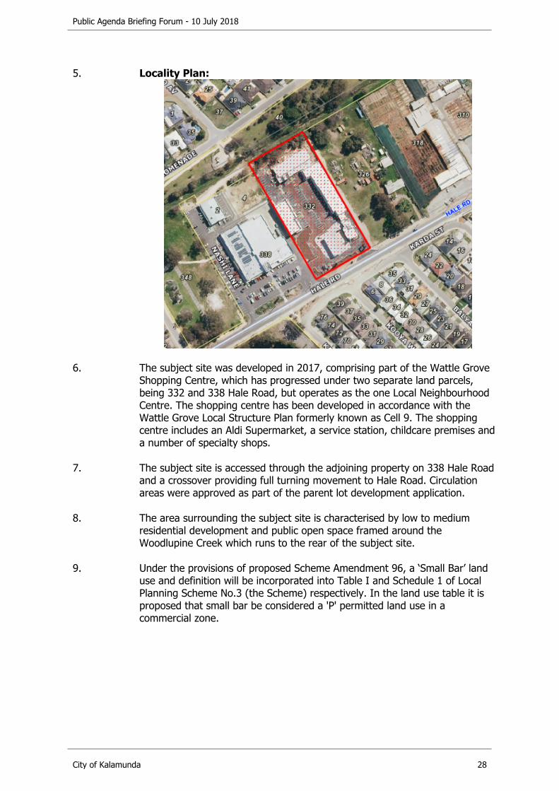
5. Locality Plan:
6. The subject site was developed in 2017, comprising part of the Wattle Grove Shopping Centre, which has progressed under two separate land parcels, being 332 and 338 Hale Road, but operates as the one Local Neighbourhood Centre. The shopping centre has been developed in accordance with the Wattle Grove Local Structure Plan formerly known as Cell 9. The shopping centre includes an Aldi Supermarket, a service station, childcare premises and a number of specialty shops.
7. The subject site is accessed through the adjoining property on 338 Hale Road and a crossover providing full turning movement to Hale Road. Circulation areas were approved as part of the parent lot development application.
8. The area surrounding the subject site is characterised by low to medium residential development and public open space framed around the Woodlupine Creek which runs to the rear of the subject site.
9. Under the provisions of proposed Scheme Amendment 96, a ‘Small Bar’ land use and definition will be incorporated into Table I and Schedule 1 of Local Planning Scheme No.3 (the Scheme) respectively. In the land use table it is proposed that small bar be considered a 'P' permitted land use in a commercial zone.
Public Agenda Briefing Forum - 10 July 2018
City of Kalamunda 29
DETAILS
10. The applicant is seeking approval for change of use from 'Shop' to ‘Restaurant’ and Use not Listed (Small Bar) and associated signage on site. No external works are proposed for the existing building. Refer Attachment 1 Development Plans.
11. The development proposes to utilise the existing building with an entrance doorway to a seating area including a kitchen, food store and bar counter area located to the rear. Toilet facilities are located to the rear left hand side and a nominated play area for small children is located in the central section adjoining the kitchen wall in view of most of the seating areas.
12. The development proposes to utilise a portion of the 114 car parking bays on site associated with the original development. No additional parking is to be provided.
13. The proposed hours of operation are Monday to Wednesday and Sundays 10:00am to 10:30pm, Thursday 10:00am to 11:00pm, Friday and Saturday 10:00am to 12:00pm midnight.
14. Live 'Sunday session' style music entertainment will be held between 12:00pm noon to 6:00pm on Sundays.
15. The proposal is described as a family friendly restaurant and bar with occasional live music performances and the provision of American style tapas and pub style meals. The proposal incorporates an estimated 120 people maximum at any one time including staff.
16. The applicant is applying for a Section 39 & Section 40 liquor license via the relevant government agency and has advised that a restaurant license and bar license has also been applied for, primarily so patrons can stand at tables with beverages. A restaurant license restricts patrons to remaining seated whilst drinking. The primary use is intended to be a seated restaurant and a food menu will be readily available at all times. It is anticipated sports will play on the TV during daytime hours to attract patrons and no TAB facilities are proposed.
17. Part of the seating area can be partitioned off for private functions, and there is a play area enclosed with a fence and gate provided for small children.
18. An illuminated signage box approximately 700mm x 1700mm is proposed to the front entrance of the tenancy, as well as an insert into the existing Wattle Grove Shopping Centre pylon sign that is 3096mm x 753mm. The applicant is also proposing logo stickers on the windows and doors, and white frosted glass to a maximum of 1m from the floor level.
19. Waste disposal is to occur in a skip bin to the rear of the adjoining 7/Eleven drive-through area.
Public Agenda Briefing Forum - 10 July 2018
City of Kalamunda 30
STATUTORY AND LEGAL CONSIDERATIONS
20. Planning and Development (Local Planning Schemes) Regulations 2015 (the Regulations)
In considering an application for development approval, Clause 67 of the Planning and Development (Local Planning Schemes) Regulations 2015 (the Regulations) requires that Council give due regard to a number of matters, including: a) The compatibility of the development within its settings;b) Amenity of the locality;c) The amount of traffic to be generated by the proposed development,
particularly in relation to the capacity of the road system and effect upon traffic flow and safety;
d) Any relevant submissions received on the application.
21. Local Planning Scheme No.3 (LPS3)
The site is zoned Urban Development under the provisions of the Scheme. Under Clause 4.2.1 of the Scheme, the objectives of the Urban development zone are as follows:
‘To provide orderly and proper planning through the preparation and adopted of a Structure Plan setting the overall design principles for the area.
To permit the development of land for residential purposes and for commercial and other uses normally associated with residential development.’
22. In accordance with the adopted Wattle Grove Cell 9 Local Structure Plan the
Subject Site is identified as Commercial. Under Clause 4.2.3 of the Scheme, the objectives of a commercial zone are:
‘To serve the needs of a localised area in providing for local shopping facilities, business, professional, civic, cultural. Medical and other health related services.
To ensure that development is designed to be compatible with nearby uses and zones particularly Residential zones.’
23. The applicant is seeking a change of use from Shop to Restaurant and Use not Listed (small bar). In accordance with clause 4.4.1 of the Scheme, where a specific use is mentioned in the zoning table it is deemed to be excluded from the general terms used to describe any other use.
24. In accordance with clause 4.4.2 of the Scheme where a land use is not specifically listed (such as small bar) the local government may determine that the use is consistent with the objectives of a particular zone and is therefore permitted.
Public Agenda Briefing Forum - 10 July 2018
City of Kalamunda 31
25. With respect the provision of car parking, the applicant proposes to utilise the existing 114 car bays provided as part of the original commercial development of the site. This number was calculated on the basis of a shop use at five bays per 100m2 of NLA. The applicant is seeking approval for a restaurant and small bar which have different parking standards.
26. Noting the above, the Scheme parking ratio required for a restaurant use is one parking bay for every four persons to be accommodated including staff. Based on the maximum stated patronage of the restaurant and small bar of 120 people the parking requirement specific to the proposal is 30 bays. The parking requirement for the previous use of shop was 15 car bays. On this basis there is a technical shortfall of 15 car parking bays.
27. In accordance with clause 5.7.3 of the Scheme local government may vary the parking requirements as specified in Table 3 of the Scheme where it is considered reciprocal parking may apply. With respect to reciprocal parking, consideration should be given to the following:a) The nature of the proposed development in relation to the existing or
future development of land within the immediate vicinity of the subject land;
b) The hours of operation of the intended use and abutting land uses; andc) Any such matters as the local government considers relevant, including
any legal agreements between affected landowners.
POLICY CONSIDERATIONS
28. P-DEV 41 Framework for assessing requests for variations to the number of car parks.
The Policy provides guidance for proponents and the City when considering requests for a reduction in the number of car parking bays prescribed under Table 3 of the Scheme.
29. P-DEV 42 Signage on Private Property
Part 3.1 of the Policy relates to advertising signage and outlines standards including but not limited to the following:a) Location must not be beyond the property boundary, block pedestrian or
vehicle sightlines;b) The height must be at have 2.75m clearance above ground level;c) The light intensity should be a low level and not cause nuisance;d) The signage is not to cause flashing, pulsing or flickering effects so as not
to distract drivers or cause nuisance. Part 3.5 specifically relates to the requirements for illuminated signage.
In addition, Part 3.5 – Illuminated Signs of the Policy applies:a) Constructed of incombustible material;b) Have electrical installation constructed in accordance with the S.A.A Code
3000-1976;c) Be maintained to operate as an illuminated sign;
Public Agenda Briefing Forum - 10 July 2018
City of Kalamunda 32
d) Not cause annoyance to the public;e) Not flash, rotate as to cause a distraction to drivers.
COMMUNITY ENGAGEMENT REQUIREMENTS
Internal Referrals
30. The application has been assessed by the City from an Environmental Health and Building code perspective where the following points were noted:a) It is acknowledged that residential properties are within 50m of the site
and may be affected by noise from live music events. It is recommended that a condition be applied requiring a detailed noise assessment in relation to the Environmental Protection (Noise) Regulations 1997, to the satisfaction of the City of Kalamunda prior to commencement of development.
b) The applicant is also advised that the food premises must comply with the Food Act 2008 and Food Standards Code.
c) The toilet facilities provided are acceptable and the applicant is advised that the proposal is required to demonstrate compliance with AS1428.1 for disability access both internal and external to the tenancy.
External Referrals
31. The application did not require referral to external agencies for comment.
32. The proposal was advertised from 19 April 2018 until 3 May 2018 in accordance with P-DEV 45 Public Notification of Planning Proposals, to landowners within a 100m radius of the site. A notification was posted on the website, and a sign was erected in the window of the premises. The proposal was also advertised on the City’s social media platform.
33. The application was advertised to affected landowners and 15 submissions were received comprising 10 objections, four non-objections and one submission which could not be opened (refer Attachment 3 – Submitters Table for more information). It is noted that three objections were lodged from a single property, and two other objections were also lodged from a single property.
In summary reasons for objection included:a) Proximity to the child care centre,b) The effect on young families in the area,c) Proximity to residential properties and anti-social behaviour,d) Concern about noise at night.
In summary reasons for support included:a) The proposal would be of great community benefit,b) The proposal would offer a place for social interaction and local
involvement,c) The proposal is welcomed and supported.

Public Agenda Briefing Forum - 10 July 2018
City of Kalamunda 33
FINANCIAL CONSIDERATIONS
34. Nil.
STRATEGIC COMMUNITY PLAN
Strategic Planning Alignment
35. Kalamunda Advancing Strategic Community Plan to 2027
Priority 3: Kalamunda DevelopsObjective 3.3 - To develop and enhance the City's economy.Strategy 3.3.1 - Facilitate and support the success and growth of industry and businesses.
SUSTAINABILITY
Social Implications
36. As a destination point the proposal will attract a greater number of residents to the area and provide opportunities for social interaction and live entertainment for the community.
37. It is acknowledged, that the potential for drunk or disorderly behaviour associated with patrons attending the bar does exist, which may affect nearby residents within walking distance of the shopping centre. Management of patron behaviour will be the responsibility of the owners.
Economic Implications
38. The proposal will increase commercial tenancies in the area and contribute to a night time economy.
Environmental Implications
39. The proposal may have noise implications for nearby residential properties relating to the live music events on Sundays and night time activity. The applicant will be required to comply with the Environmental Protection (Noise) Regulations 1997 (Noise Regulations).

Public Agenda Briefing Forum - 10 July 2018
City of Kalamunda 34
RISK MANAGEMENT CONSIDERATIONS
40. Risk: Increased unmanaged noise causes mental and physical distress to surrounding residential properties.
Likelihood Consequence RatingLikely Moderate HighAction/StrategyThe applicant will be required to submit a detailed noise assessment in relation to the Environmental Protection (Noise) Regulations 1997 to the satisfaction of the City of Kalamunda prior to commencing the development. Where impacts may exceed acceptable levels the applicant will be required to prepare noise mitigation plan to the City for approval.
41. Risk: Patrons cause anti-social behavior and reduce safety in the vicinity during opening hours.
Likelihood Consequence RatingPossible Moderate Medium Action/StrategyDuring night time hours increasing the number of visitors to the site is anticipated to increase safety, particularly as staff will be present to manage behavior and will be last to leave the facility so are able to take action regarding anti-social activity.
During daytime hours a greater number of people are expected to be visiting the site for other retail tenancies and the risk of anti-social behavior is therefore lessened.
42. Risk: Refusal of the application causes economic loss to the commercial centre.
Likelihood Consequence RatingPossible Moderate MediumAction/StrategyEnsure the planning rationale and merit of the proposal is properly explained in the planning report.
OFFICER COMMENT
43. The application for a change of use from a ‘Shop’ to ‘Restaurant’ and ‘Use Not Listed’ (Small bar) on the subject site, is considered consistent with the objectives of the Urban Development zone and the intent of the Wattle Grove Cell 9 Local Structure Plan in providing for commercial activities on the subject site.

Public Agenda Briefing Forum - 10 July 2018
City of Kalamunda 35
44. The City acknowledges the parking required for a restaurant is 30 bays whereas for a shop use requires 15 bays. With respect to the shortfall and having regard to clause 5.7.3 of the Scheme, it is noted that the nature of the different shops, and other land use activities, i.e. child care premises, presently operating will have differing hours of operation, principally during the daylight hours, whilst patrons to the proposed restaurant and small bar are likely to peak during evening hours. On this basis, the shortfall in parking is considered acceptable given the opportunity for reciprocal parking likely to occur on the site.
45. Furthermore, two bus stops are located at either end of the shopping complex where the premises are located. Nearby local residents are also anticipated to walk to the premises where practical.
46. With regard to community objections the following comment is provided: a) Antisocial Behaviour – it is acknowledged that the potential for
antisocial behaviour associated with the consumption of alcohol on the premises does exist. However, the extent to which this is managed is the responsibility of the owners and ultimately the Police if necessary. In considering this issue, it should be noted that the applicant is proposing a family friendly operation, which should lessen the potential for such behaviour. The demographic within the locality is also generally characterised by families with children.
b) Noise - Whilst noise from patrons and live music is a factor, live music from noon-6pm on Sunday is restricted by virtue of the Noise Regulations and is unlikely to affect regular sleeping patterns for nearby residential properties. The applicant has confirmed noise during any other hours will be ambient background music or from the sports on the TV, which is considered reasonable. The opening hours are considered appropriate given the nature of the development.
c) Parking - With a maximum capacity of 120 people the parking required was found to be 30 bays. The existing number of car parking bays onsite is 114 bays and is considered reciprocal between all tenancies. The City acknowledges other tenancies have daylight opening hours while patrons to the proposed restaurant and small bar are likely to peak during evening hours. In this case the number of car parking bays provided is considered sufficient.
47. Noting the above, it is recommended the application be supported subject to appropriate conditions.

Public Agenda Briefing Forum - 10 July 2018
City of Kalamunda 36
Voting Requirements: Simple Majority
RECOMMENDATION
That Council:
1. APPROVES the proposed Change of Use from Shop to Restaurant and Use Not Listed (Small Bar) at Lot 33 (332) Hale Road, Forrestfield subject to the following conditions:
a) The proposal, subject of this approval shall be carried out only in accordance with the terms of this approval and any approved plan. If the development is not substantially commenced within a period of two years from the date of this approval, the approval shall lapse and be of no further effect. Where an approval has lapsed, no development shall be carried out without further approval from the City of Kalamunda.
b) The development shall be connected to reticulated sewer.c) The applicant is required to engage an appropriately qualified acoustic consultant
(such as a member of the Australian Acoustical Society or the Association of Australian Acoustical Consultants) to undertake a detailed noise assessment in relation to the Environmental Protection (Noise) Regulations 1997 to the satisfaction of the City of Kalamunda prior to commencing the development. Where such an assessment finds the proposal fails to meet the legislative limits the proponent must submit a noise mitigation plan for approval of the City of Kalamunda prior to commencing the development.
d) The hours of operation shall be limited to Monday to Wednesday and Sundays 10am to 10.30pm, Thursday 10am to 11pm, Friday and Saturday 10am to 12 midnight.
e) The total number of visitors to the tenancy one (T1) premises, including staff, shall not exceed 120 individuals at any one time.
f) Live music shall be limited to the hours of 12pm (noon) to 6pm on Sunday only.g) Illuminated signage is to be constructed in accordance with P-DEV 42 Signage on
Private Property, Part 3.1 Standards and Part 3.5 - Illuminated Signage, and thereafter maintained to the satisfaction of the City of Kalamunda.
Public Agenda Briefing Forum - 10 July 2018
City of Kalamunda 37
10.2. Asset Services Reports
10.2.1. Drainage Asset Management Plan 2018
The Manager Asset Planning & Management provided a presentation on this item. There were no questions from Councillors. Questions from the public were clarified.
Declaration of financial / conflict of interests to be recorded prior to dealing with each item.
Previous Items OCM 130/2012 – Adoption of the revised Asset Management PolicyOCM 157/2016 – Review of Asset Management Policy ENG15OCM 79/2017 – Pathways Asset Management Plan 2017OCM 125/2017 – Review of Asset Management Strategy 2017 - 2021OCM 140/2017 – Parks Asset Management Plan 2017
Directorate Asset ServicesBusiness Unit Asset Planning & ManagementFile Reference HU-PAA-013Applicant N/AOwner N/A
Attachments 1. Drainage Asset Management Plan Rev 1.3 [10.2.1.1]
EXECUTIVE SUMMARY
1. To consider endorsement of the City of Kalamunda Drainage Asset Management Plan 2018 (Drainage AMP) and set the objective of maintaining the current funding levels for renewals.
2. This Drainage AMP is an update of the set of asset management plans prepared in 2013 and identifies 86 basins, 15,708 pits and 220 km of drains. The drainage assets are valued at $87.59 million, which includes a management valuation of 44% of drain assets not yet collected.
3. This report recommends endorsement of the City of Kalamunda Drainage Asset Management Plan 2018 and retention of the current average funding level for drainage assets renewals.
BACKGROUND
4. The City produced its first asset management plan for drainage in 2013. Subsequently in 2016 the Asset Management Council Policy was revised, and a number of internal processes improved, resulting in a revised Asset Management Strategy, new Pathways and Parks Asset Management Plans (adopted in 2017) and this proposed new Drainage AMP.
Public Agenda Briefing Forum - 10 July 2018
City of Kalamunda 38
DETAILS
5. The Drainage AMP covers the following subjects:a) Current Status of Assets;b) Levels of Service;c) Life Cycle Management;d) Risk Management;e) Future Demand;f) Financial Summary;g) Improvements, Monitoring and Review.
6. The current status of assets identifies 86 Basins, 15,708 Pits and 220 kilometres of Drains (56% of Drains asset data collected to date).
7. The average condition rating of drainage assets is reported in three categories as listed below, with the average condition in brackets:a) Drains (1.9);b) Pits (2.5);c) Basins (1.7).
8. Visual condition inspections of drainage assets have not yet been undertaken. The condition rating of drainage assets is based on age using the percentage of the total remaining useful life of the asset. This is a satisfactory method of assigning condition rating as the life of drainage assets is in excess of 80 years. The City now needs to undertake detailed visual condition inspections and condition rating using a sampling methodology.
9. “Levels of Service” is a phrase used in asset management to reflect the service the assets provide to the community. The City conducted community consultation in 2018 to understand the expectations of asset levels of service. Three quarters of respondents agreed that the City’s drainage assets are working to an acceptable level. In a 2016 Community Satisfaction Survey, 87% of respondents stated that they are satisfied with the service provided by the City’s stormwater drainage.
10. The section of the Drainage AMP on Future Demand addresses the growth in population, developments, and the impact of climate change on drainage assets. The plan recommends the preparation of a comprehensive Stormwater Management Plan (SWMP) to estimate future asset requirements.
11. The Financial Summary section of the Drainage AMP addresses fair value, key performance indicators, current funding levels, funding gap analysis and funding scenarios is presented later in the Plan. Due to the need to complete the data collection and condition ratings of Drains assets, the continuation of the current average funding level of $628,000 per year for drainage asset renewals is the recommended action. This may result in a reduction in the overall average condition rating over ten years, from 2.46 to 3.07. Once the data collection is complete, the Drainage AMP can be updated with new funding scenarios.
Public Agenda Briefing Forum - 10 July 2018
City of Kalamunda 39
12. The Drainage AMP will be reviewed again in three years. During this period the drainage data and the associated practices will be improved, with the following objectives:a) Complete the asset register by collecting and mapping all City Drains and
conducting visual condition ratings for a representative sample of drainage assets (2018/2019 and 2019/2020);
b) Develop a Stormwater Management Plan (2019/2020);c) Develop a Stormwater Maintenance Management Plan based on asset
criticality, risk and maintenance service levels (2019/2020);d) Add drainage assets containing asbestos to the asbestos register
(2019/2020).
STATUTORY AND LEGAL CONSIDERATIONS
13. All local governments are currently required to produce a plan for the future under S5.56 (1) of the Local Government Act 1995. Asset Management Plans are informing strategies for the Strategic Community Plan, Corporate Business Plan, Long Term Financial Plan, and Integrated Planning and Reporting Framework.
POLICY CONSIDERATIONS
14. The Drainage AMP is prepared in support of the Asset Management Policy, (AS-01) and Asset Management Strategy 2017-2021.
COMMUNITY ENGAGEMENT REQUIREMENTS
Internal Referrals
15. The draft Drainage AMP was reviewed by the Asset Management Steering Committee prior to finalising this report.
External Referrals
16. Asset Management Plans are informed by a “levels of service” process which is the result of a community consultation process. The consultation undertaken to provide direction to the Drainage AMP was through the 2016 Community Satisfaction Survey and the Asset Level of Service Community Consultation 2018 as per the requirements of the City’s Asset Management Strategy 2017-2021.
FINANCIAL CONSIDERATIONS
17. The City currently forecasts a total average annual amount of $628,000 for capital expenditure on drainage assets renewals.
18. Financial modelling of the drainage asset conditions has identified that the City has the options of either improving the average condition or maintaining it at the current level.
Public Agenda Briefing Forum - 10 July 2018
City of Kalamunda 40
The recommended scenario is to maintain the current level of drainage renewal funding, which will result in the assets being renewed when they reach a ‘Very Poor’ condition. Drainage assets are considered long life assets with an expected useful life of more than 80 years.
19. Notable renewal funding needs in 2018/2019 include:a) $760,000 for channel and pond improvements in Stirk Park;b) $225,000 for Booligal Street drainage pipe renewal and upgrade.
20. The Drainage AMP also includes three financial ratios, being the Asset Consumption Ratio, the Asset Sustainability Ratio, and the Asset Renewal Funding Ratio.
21. The Asset Consumption Ratio has been determined as 0.20, while the desired is 0.50 or greater. A score of 0.50 means that the assets are half depreciated (consumed), and this is a reasonable objective. This ratio is low due to the method of depreciating assets that was used in the last comprehensive valuation in 2015. The effect of the method used (reducing balance consumption curve) is to depreciate assets at higher rate when the condition (service potential) of assets is high. This methodology is being reviewed as part of the 2018 Infrastructure Revaluation.
22. The Asset Sustainability Ratio is 0.58 and is desired to be 0.90 or greater. The ratio is calculated for the 2018–2028 period using the current LTFP renewal budgets for asset renewals and annual depreciation from the 2015 asset valuation. This ratio has an inherent bias as it only measures the next ten years of renewals, whereas the depreciation value reflects the entire life of the assets (80 years for pipes, for example). The City’s age matrix shows many assets have a much longer expected remaining useful life than ten years. As the Drainage AMP is reviewed every three years, this measure will be updated with new condition information.
23. The Asset Renewal Funding ratio is 0.70 and is desired to be between 0.75 and 0.95. The ratio is calculated for the 2018-2028 period using the current LTFP renewal budgets and the funding required to maintain the current average drainage network condition. The renewal cost excludes any asset upgrades. Based on the confidence level of current data and 44% of drain assets not yet collected it is proposed to maintain funding for drainage assets at current levels. As the Drainage AMP is reviewed every three years, this measure will be updated with new condition information.
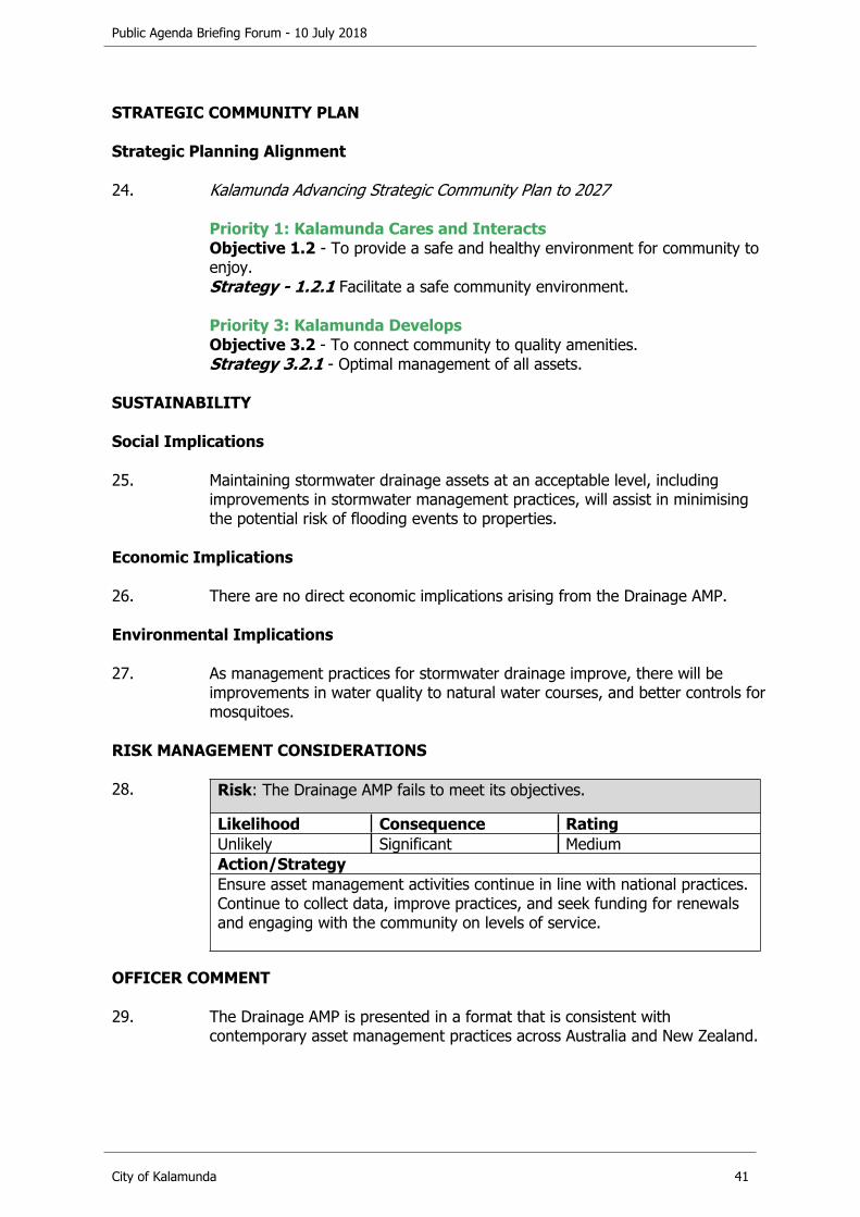
Public Agenda Briefing Forum - 10 July 2018
City of Kalamunda 41
STRATEGIC COMMUNITY PLAN
Strategic Planning Alignment
24. Kalamunda Advancing Strategic Community Plan to 2027
Priority 1: Kalamunda Cares and InteractsObjective 1.2 - To provide a safe and healthy environment for community to enjoy.Strategy - 1.2.1 Facilitate a safe community environment.
Priority 3: Kalamunda DevelopsObjective 3.2 - To connect community to quality amenities.Strategy 3.2.1 - Optimal management of all assets.
SUSTAINABILITY
Social Implications
25. Maintaining stormwater drainage assets at an acceptable level, including improvements in stormwater management practices, will assist in minimising the potential risk of flooding events to properties.
Economic Implications
26. There are no direct economic implications arising from the Drainage AMP.
Environmental Implications
27. As management practices for stormwater drainage improve, there will be improvements in water quality to natural water courses, and better controls for mosquitoes.
RISK MANAGEMENT CONSIDERATIONS
28. Risk: The Drainage AMP fails to meet its objectives.
Likelihood Consequence RatingUnlikely Significant MediumAction/StrategyEnsure asset management activities continue in line with national practices. Continue to collect data, improve practices, and seek funding for renewals and engaging with the community on levels of service.
OFFICER COMMENT
29. The Drainage AMP is presented in a format that is consistent with contemporary asset management practices across Australia and New Zealand.

Public Agenda Briefing Forum - 10 July 2018
City of Kalamunda 42
30. The financial modelling that identified the average condition rating and funding requirements, is considered an ‘Intermediate’ level practice in terms of asset management maturity.
31. As the recent 2018 Levels of Service Consultation and 2016 Customer Satisfaction Survey indicates a positive perception of drainage assets, it is recommended that the average condition of the drainage assets be maintained at current levels and no additional funding is required.
32. Through the scenario modelling process, the Drainage AMP provides ten year funding options, and assists in the development of appropriate drainage assets renewal programs.
Voting Requirements: Simple Majority
RECOMMENDATION
That Council:
1. ENDORSES the Drainage Asset Management Plan 2018 and sets the objective of maintaining the funding for drainage asset renewals at current levels.

Public Agenda Briefing Forum - 10 July 2018
City of Kalamunda 43
10.3. Corporate Services Reports
10.3.1. Proposed Permanent Road Closure - Portions of Setosa Drive, Forrestfield
The Director Corporate Services provided a presentation on this item. Questions from Councillors were clarified. There were no questions from the public.
Declaration of financial / conflict of interests to be recorded prior to dealing with each item.
Previous Items NilDirectorate Corporate ServicesBusiness Unit Economic, Land & Property ServicesFile Reference 155243; ST-21/GENApplicant Rowe GroupOwner State of Western Australia
Attachments 1. Subdivision Approval Western Australian Planning Commission (WAPC) Ref. 155243 [10.3.1.1]
2. Letter from Rowe Group dated 17 November 2017 [10.3.1.2]
EXECUTIVE SUMMARY
1. The purpose of this Report is to consider a request to permanently close portions of Setosa Drive, Forrestfield.
2. This is necessary in order to facilitate subdivision forming part of the Hales development.
3. It is recommended that Council support the request to close portions of Setosa Drive, subject to conditions.
BACKGROUND
4. Locality Plan:

Public Agenda Briefing Forum - 10 July 2018
City of Kalamunda 44
5. The proposed road closure is required to facilitate a subdivision that forms part of the Hales development. A copy of subdivision approval Western Australian Planning Commission (WAPC) Ref. 155243 is attached as Attachment 1.
DETAILS
6. The Rowe Group acts on behalf of Satterley Property Group (SPG) in respect of their landholding comprising Lot 9003 Gala Way, The Hales, Forrestfield (Lot 9003).
7. On 17 November 2017, the Rowe Group wrote to the City requesting that the City initiate:a) the excision of a 744-square metre portion of Reserve 37650 to be
dedicated as road reserve to facilitate the future subdivision of lots as part of the Hales development;
b) the closure of portions of Setosa Drive to be amalgamated with Lot 9003 and incorporated into proposed lots subject to subdivision approval WAPC Ref. 155243.
A copy of the Rowe Group’s 17 November 2017 letter is attached as Attachment 2.
8. The following plans are attached to the Rowe Group’s 17 November 2017 letter:a) Proposed Crown Subdivision and Road Closures Crown Reserve 37650 &
Setosa Drive Forrestfield;b) Modified Plan of Subdivision;c) Local Structure Plan.
9. The City wrote to the Rowe Group on 28 February 2018 advising that it was unable to support the proposed excision and dedication, as the City would lose part of its public open space without compensation. Further, if the relevant portion of Reserve 37650 was dedicated as road, the landowner, SPG, would not need to use part of its freehold land for the purposes of road reserve and would therefore benefit from having additional land to use for the creation of residential lots. The City is unable to support a proposal whereby SPG would obtain the commercial benefit of additional developable area at no cost. This position is consistent with advice received from the Lands Division of the Department of Planning, Lands & Heritage.
10. Although the City is unable to support the proposed excision and dedication, the City advised the Rowe Group that it is willing to support SPG purchasing the 744-square metre portion of Reserve 37650 from the State of Western Australia at market value and amalgamating that portion of land into its freehold land, pursuant to s. 87 of the Land Administration Act 1997 (WA). Once the relevant land has been amalgamated into SPG’s freehold, SPG could then proceed to dedicate that portion of land on the plan of subdivision.
Public Agenda Briefing Forum - 10 July 2018
City of Kalamunda 45
11. The City further advised SPG that the City would proceed to advertise the proposed road closure.
STATUTORY AND LEGAL CONSIDERATIONS
12. Section 58 of the Land Administration Act 1997 relates to permanent road closures.
13. Section 58(1)-(3) states as follows:
58. Closing roads(1) When a local government wishes a road in its district to be closed
permanently, the local government may, subject to subsection (3), request the Minister to close the road.
(2) When a local government resolves to make a request under subsection (1), the local government must in accordance with the regulations prepare and deliver the request to the Minister.
(3) A local government must not resolve to make a request under subsection (1) until a period of 35 days has elapsed from the publication in a newspaper circulating in its district of notice of motion for that resolution, and the local government has considered any objections made to it within that period concerning the proposals set out in that notice.
POLICY CONSIDERATIONS
14. The City’s Asset Management Policy (C-AS-01) states that “As part of acontinuous improvement process, the Shire of Kalamunda will continuallymonitor, audit and review its asset portfolio to ensure it is responsive toservice delivery needs and meets the goals and targets set by Council.”
15. A review of the portion of road reserve proposed to be closed indicates that it is surplus to the future requirements of the road network in light of subdivision approval WAPC Ref. 155243. Further, if the road closure does not occur, the proposed subdivision will create an irregularly shaped lot.
COMMUNITY ENGAGEMENT REQUIREMENTS
Internal Referrals
16. The City has assessed the request and has no objection to the proposed road closure, subject to the subdivision development approval conditions applying to development of this lot, that is, identification and protection of significant vegetation, landscaping to the City’s satisfaction, dual use path provided.
17. The City has no objection to the proposed road closure and does not require any conditions to be imposed.
Public Agenda Briefing Forum - 10 July 2018
City of Kalamunda 46
External Referrals
18. The proposal was advertised in the Hills Gazette on 23 March 2018, the Kalamunda Reporter on 27 March 2018, the Echo Newspaper on 7 April 2018 and on the City’s website. Comments closed on 1 May 2018. No public submissions were received.
19. The proposal was also referred to the service authorities for comment.
20. Telstra’s plant records indicate that there are Telstra assets in the vicinity. Subject to compliance with Telstra’s standard conditions, Telstra has no objection to the proposed closure.
21. ATCO Gas operates medium pressure gas mains within the opposite side road reserve of Setosa Drive. ATCO Gas has no objection to the proposal.
22. Western Power does not have any objection to the proposal, but would appreciate being kept informed of developments.
23. Water Corporation has no objection to the proposed closure.
FINANCIAL CONSIDERATIONS
24. The applicant should be required to meet all costs of the proposal, including the cost of any easements and service relocations required by the service authorities.
STRATEGIC COMMUNITY PLAN
Strategic Planning Alignment
25. Kalamunda Advancing Strategic Community Plan to 2027
Priority 3: Kalamunda DevelopsObjective 3.1 - To plan for sustainable population growth.Strategy 3.1.1 - Plan for diverse and sustainable housing, community facilities and industrial development to meet changing social and economic needs.
SUSTAINABILITY
Social Implications
26. The proposal will not have any social or lifestyle impacts on residents.
Economic Implications
27. The economic lives of residents will not be impacted by this decision.

Public Agenda Briefing Forum - 10 July 2018
City of Kalamunda 47
Environmental Implications
28. Parks & Environment have requested that the subdivision approval conditions apply to development of this land. Subdivision approval WAPC Ref. 155243 contains conditions relating to the identification and protection of significant vegetation, landscaping to the City’s satisfaction and the provision of a dual use path.
RISK MANAGEMENT CONSIDERATIONS
29. Risk: The proposed permanent road closure does not occur.
Likelihood Consequence RatingUnlikely Significant MediumAction/StrategyDemonstrate that a failure to close the relevant portions of Setosa Drive will result in the creation of an irregularly shaped lot. Demonstrate that the road closure will create a uniform streetscape in that location.
30. Risk: The proposed permanent road closure occurs, but the proposed
subdivision WAPC Ref. 155243 does not proceed.
Likelihood Consequence RatingUnlikely Insignificant LowAction/StrategyIt is highly unlikely that proposed subdivision WAPC Ref. 155243 will not proceed. However, even if the proposed subdivision does not occur, the road closure should still proceed, as it will straighten the road reserve.
OFFICER COMMENT
31. The proposed permanent road closure will facilitate a future subdivision (WAPC Ref. 155243) that forms part of the Hales development.
32. If the road closure does not occur, the proposed subdivision will create an irregularly shaped lot.
33. The service authorities do not have any objection to the proposed road closure.
34. No public submissions were received in respect of the proposal.
35. It is recommended that Council support the request to close portions of Setosa Drive, subject to the following conditions: a) The subdivision approval conditions (WAPC Ref. 155243) to apply to the
portions of road reserve proposed to be closed;b) The applicant must pay all costs of and incidental to any easements and
service relocations required by the service authorities;c) The applicant must pay any other costs of and incidental to the proposal.

Public Agenda Briefing Forum - 10 July 2018
City of Kalamunda 48
Voting Requirements: Simple Majority
RECOMMENDATION
That Council:
1. REQUESTS the Minister for Lands to permanently close those portions of the Setosa Drive, Forrestfield road reserve shown delineated and marked as “Proposed Road Closure 63 m2” and “Proposed Road Closure 13 m2” on the plan entitled “Proposed Crown Subdivision & Road Closures Crown Reserve 37650 & Setosa Drive Forrestfield”, pursuant to section 58 of the Land Administration Act 1997 (WA), subject to the following conditions:
a) The subdivision approval conditions (WAPC Ref. 155243) to apply to the portions of road reserve proposed to be closed;
b) The applicant must pay all costs of and incidental to any easements and service relocations required by the service authorities; and
c) The applicant must pay any other costs of and incidental to the proposal.
Public Agenda Briefing Forum - 10 July 2018
City of Kalamunda 49
10.4. Office of the CEO Reports
10.4.1. Stirk Park Master Plan -Result of Public Comment on Inclusion of a Skate Park
The Coordinator Community Services provided a presentation on this item. No questions were asked from Councillors or the public.
Declaration of financial / conflict of interests to be recorded prior to dealing with each item.
Previous Items OCM 75/2017OCM 216/2017
Directorate Office of the CEOBusiness Unit Recreation Facilities & ServicesFile ReferenceApplicant City of KalamundaOwner City of Kalamunda
Attachments 1. Attachment One - Proposed Location of Skate Park - Stirk Park.docx [10.4.1.1]
Confidential Attachment
Attachment Two – Public Comment – Stirk Park Skate Park 2018
EXECUTIVE SUMMARY
1. The purpose of this report is to consider the outcomes of the community engagement process regarding the potential relocation of the Kalamunda Skate Park, located on Canning Road to Stirk Park.
2. At the Ordinary Council Meeting held on the 28 November 2017, a youth driven petition seeking the inclusion of a Skate Park into the Stirk Park Master Plan, with 187 signatures was presented to Council. In response to the petition the City undertook further community engagement over a 30-day period.
3. A total of 243 responses were submitted to the City and a majority supported a relocation of the Skate Park to Stirk Park.
4. It is recommended that Council support an amendment of the Stirk Park Master Plan to include a Skate Park, in lieu of the Pump Track, within the Youth Precinct area and the commencement of the detailed design process for Stage One.
BACKGROUND
5. At the OCM held on the 28 November 2017, a deputation was received, and a petition presented by two youths from the community in relation to Item 10.1.3, Stirk Park Master Plan – Public Comment, in support of the Kalamunda Skate Park being included within Stirk Park.

Public Agenda Briefing Forum - 10 July 2018
City of Kalamunda 50
6. After considering the above, and the Officers report on the draft Stirk Park Master Plan, Council resolved as follows: RESOLUTION OCM 216/2017
That Council:
1. Adopts the final Stirk Park Master Plan to be used as a conceptual, strategic tool guiding future developments with more detailed scoping, consultation and design to be applied to the implementation of the prioritised component parts.
2. Supports the commencement of more detailed scoping, consultation and detailed design for the following 1-3 year priorities: Playground Upgrade Youth and Sport Precinct; and Path network upgrade.
3. Notes that the remaining stage two and three development proposals will be subject to sourcing external funding, annual budget deliberations and the competing priorities in the Long Term Financial Plan.
4. Consider the inclusion of a skate park within the youth and sport precinct and then the closure of the existing skate park located on Canning Road in Kalamunda.
7. In accordance with point 4 of the above resolution, a period of further community engagement was undertaken, to consider the inclusion of a skate park within the Stirk Park Master Plan.
DETAILS
8. Following the adoption of the Stirk Park Master Plan, further community engagement was required to consider the inclusion of a skate park within the Youth and Sport Precinct at Stirk Park, and the closure of the existing skate park on Canning Road.
9. Officers commenced a 30-day engagement strategy with the community in March 2018 to determine the level of support prior to re-presenting back to Council for final consideration.
10. It is proposed to locate the skate park in the north west corner of the park adjacent to the Youth Precinct to provide families with the opportunity to recreate together in the one area. This would also see the skate park located away from areas where other more cultural activities take place.(Attachment One – Proposed Location of Skate Park)
11. The Community Engagement and Public Comment feedback, provided a positive response to the proposal to include a skate park as part of the Stirk Park Master Plan.

Public Agenda Briefing Forum - 10 July 2018
City of Kalamunda 51
12. A summary of the public comments received in relation to the proposal have been included in this report (Attachment 2).
Results from the surveys showed that:a) 243 survey responses were received;b) 75% of respondents were aged over 25, with largest amount of responses
from the 36-45 age group;c) 70% or 171 respondents supported the proposed relocation to Stirk Park;d) 29% or 70 respondents were opposed to the proposal;e) 136 rated the overall current condition of the Kalamunda Skate Park as
“Poor or Very Poor”;f) 129 of responders noted that they did not feel safe at the location either
due to the condition of the park or the proximity to a main road;g) 29 respondents suggested that the skate park could be relocated
elsewhere.
13. The City also received five written submissions, all of whom were opposed to the relocation proposal.
14. Of those opposed, the following themes emerged:a) Family oriented feel and tranquillity within the park may be lost;b) Skate park may not be compatible with other activities currently held
throughout the park; Opera in the Park, Jazz in the Park, etc.
STATUTORY AND LEGAL CONSIDERATIONS
15. Nil.
POLICY CONSIDERATIONS
16. Policy – FAC22 – The Cash – in- lieu Assessment Criteria Policy provides strategic direction to Council’s decision making on proposed cash in lieu projects for which Stirk Park may be eligible, as it is regarded as a district level park.
COMMUNITY ENGAGEMENT REQUIREMENTS
Internal Referrals
17. The City regards the proposed location as appropriate for the skate park.
External Referrals
18. The opportunity for public comment was promoted widely through:
a) Seven Community Drop In sessions at various locations;b) Newspaper advertising in local community papers;c) Letters to local residents and businesses within 300m of the park;d) Emails to local schools promoting proposal and survey details;e) Meeting with Kalamunda Club Inc.;f) Online survey through the City’s Engagement Portal;
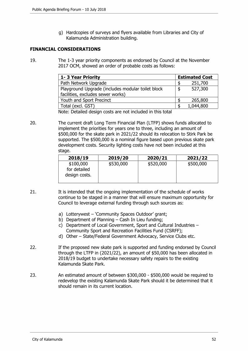
Public Agenda Briefing Forum - 10 July 2018
City of Kalamunda 52
g) Hardcopies of surveys and flyers available from Libraries and City of Kalamunda Administration building.
FINANCIAL CONSIDERATIONS
19. The 1-3 year priority components as endorsed by Council at the November 2017 OCM, showed an order of probable costs as follows:
1- 3 Year Priority Estimated CostPath Network Upgrade $ 251,700Playground Upgrade (includes modular toilet block facilities, excludes sewer works)
$ 527,300
Youth and Sport Precinct $ 265,800Total (excl. GST) $ 1,044,800
Note: Detailed design costs are not included in this total
20. The current draft Long Term Financial Plan (LTFP) shows funds allocated to implement the priorities for years one to three, including an amount of $500,000 for the skate park in 2021/22 should its relocation to Stirk Park be supported. The $500,000 is a nominal figure based upon previous skate park development costs. Security lighting costs have not been included at this stage.
2018/19 2019/20 2020/21 2021/22$100,000
for detailed design costs.
$530,000 $520,000 $500,000
21. It is intended that the ongoing implementation of the schedule of works continue to be staged in a manner that will ensure maximum opportunity for Council to leverage external funding through such sources as:
a) Lotterywest – ‘Community Spaces Outdoor’ grant;b) Department of Planning – Cash In Lieu funding;c) Department of Local Government, Sport and Cultural Industries –
Community Sport and Recreation Facilities Fund (CSRFF);d) Other – State/Federal Government Advocacy, Service Clubs etc.
22. If the proposed new skate park is supported and funding endorsed by Council through the LTFP in (2021/22), an amount of $50,000 has been allocated in 2018/19 budget to undertake necessary safety repairs to the existing Kalamunda Skate Park.
23. An estimated amount of between $300,000 - $500,000 would be required to redevelop the existing Kalamunda Skate Park should it be determined that it should remain in its current location.
Public Agenda Briefing Forum - 10 July 2018
City of Kalamunda 53
STRATEGIC COMMUNITY PLAN
Strategic Planning Alignment
24. Kalamunda Advancing Strategic Community Plan to 2027
Priority 1: Kalamunda Cares and InteractsObjective 1.2 - To provide a safe and healthy environment for community to enjoy.Strategy - 1.2.3 Provide high quality and accessible recreational and social spaces and facilities. Strategy 1.2.2 - Advocate and promote healthy lifestyle choices by encouraging the community to become more physically active.Strategy - 1.2.1 Facilitate a safe community environment.
Priority 1: Kalamunda Cares and InteractsObjective 1.3 - To support the active participation of local communities.Strategy 1.3.1 - Support local communities to connect, grow and shape the future of Kalamunda.
SUSTAINABILITY
Social Implications
25. The inclusion of a skate park as part of the Youth precinct, promotes opportunities for intergenerational activity to take place. It also includes an inclusive, active and safe place for people to come together.
26. Skate boarding and scootering are both activities that are undertaken by many adults as well as children. The inclusion of a skate park allows parents to interact with their children, rather than observing through the playground type activities usually provided.
Economic Implications
27. The enhancement of Stirk Park to a suitable District Level Park will attract increased usage and visitation locally and beyond, consequently providing spin off benefits to the local economy and businesses, particularly within the Kalamunda Town Centre.
Environmental Implications
28. Consideration will need to be given to minimise any potentially negative impact on the natural environment of the park.

Public Agenda Briefing Forum - 10 July 2018
City of Kalamunda 54
RISK MANAGEMENT CONSIDERATIONS
29. Risk: Resistance from residents in close proximity to Stirk Park and from some users of the park in regard to disturbance from the skate park.
Likelihood Consequence RatingPossible Moderate MediumAction/StrategyRegulate hours and consider installation of security lighting and potentially CCTV.Locate the skate park in the area adjacent to the Youth Precinct and away from areas where cultural activities are held.
OFFICER COMMENT
30. The community consultation process undertaken resulted in 243 submissions being received with a majority supporting the inclusion of a skate park within the Stirk Park Master Plan.
31. The benefits of relocating the skate park included;
a) Popular activity for teenage element within Stirk Park;b) Opportunity for a modern facility to be designed and integrated with other
family activities/facilities within the park;c) Improved connectivity to the town centre;d) Security - Passive surveillance;e) Access to toilets, drinking fountain, shade, etc.;f) Parking and access.
32. The concerns or limitations with the existing skate park location included;
a) No toilets or shade shelter;b) Somewhat disconnected to town centre;c) Limited options to expand existing facility;d) Ageing facility/safety concerns will require significant upgrade;e) Not a contemporary skate park design.
33. The two main themes raised through the consultation period in opposition to the skate park relocation were, an increase in noise, and concern that a skate park would affect the tranquillity of the park.
34. In response to these concerns, the skate park has been located to an area of Stirk Park that is largely underutilised, has natural screening from nearby residents and is some distance from the majority of cultural activities. The location will also form part of an expanded youth precinct and compliment the available activities.
35. Consideration will also be given to the installation of security lighting, ensuring that the hours of use are restricted to largely daylight hours.
Public Agenda Briefing Forum - 10 July 2018
City of Kalamunda 55
Voting Requirements: Simple Majority
RECOMMENDATION
That Council:
1. APPROVES an amendment to the Stirk Park Master Plan to include a skate park within the Youth Precinct Area, in lieu of the pump track.
2. APPROVES the progression of detailed designs for the following Stage One priorities:a) Playground Upgrade;b) Youth and Sport Precinct;c) Path Network Upgrade.
36. Further consultation with the Community would be undertaken to support the detailed design process for a skate park to be located within Stirk Park.
37. Given the level of community support to relocate the skate park to Stirk Park, it is recommended that Council support the inclusion of a skate park within the Stirk Park Master Plan and remove the Pump Track.

Public Agenda Briefing Forum - 10 July 2018
City of Kalamunda 56
10.4.2. Maida Vale Reserve Master Plan
The Coordinator Community Services provided a presentation on this item. Questions were asked by Councillors and clarified. There were no questions from the public.
Declaration of financial / conflict of interests to be recorded prior to dealing with each item.
Previous ItemsDirectorate Office of the CEOBusiness Unit Recreation Facilities & ServicesFile Reference PR-PLN-009Applicant City of KalamundaOwner City of Kalamunda
Attachments 1. Maida Vale Reserve MP Final Draft Report 140618 [10.4.2.1]
EXECUTIVE SUMMARY
1. The purpose of this report is to provide the findings from the draft Maida Vale Reserve Master Plan (the Plan).
2. The Plan outlines development opportunities and recommendations in terms of facility provision, playing field space expansion and other future requirements to guide the sustainable development of Maida Vale Reserve.
3. It is recommended that Council:
a) Receives the Draft Maida Vale Reserve Master Plan;b) Advertises the plan for a period of 40 days;c) Notes the community engagement process;d) Requests all affected user groups and stakeholders be provided with a
copy of the Draft Maida Vale Reserve Master Plan.
BACKGROUND
4. Maida Vale Reserve, located in Maida Vale, is Crown Land vested with the City for purposes of recreation (14.37ha) and conservation (16.22ha).
5. The Community Facilities Plan (2011- 2031) suggested the need to undertake a master planning process for the site.
6. The Public Open Space Strategy, recently adopted by Council at OCM 22 May 2018, indicated that Maida Vale Reserve may be required to cater for additional sports spaces that are not available in neighbouring suburbs.
7. Maida Vale Reserve has facilities and supporting infrastructure that service a diverse range of user groups.
Public Agenda Briefing Forum - 10 July 2018
City of Kalamunda 57
8. The key factors providing the catalyst for the development of the Plan include:a) An increasing number of requests from user groups to improve and
upgrade facilities and flood lighting on the Reserve;b) The ageing nature of the majority of facilities;c) Increasing usage demands on the reserve, negatively impacting surface
standards;d) A need to investigate potential options to maximise the efficient usage of
the existing grounds/facilities and unused outdoor netball courts;e) The need to undertake a coordinated approach toward any future
developments with Maida Vale Reserve.
9. A Community Sport and Recreation Facilities Fund grant application was submitted to the Department of Local Government, Sport and Cultural Industries in 2017 to engage a consultant to assist in undertaking a Master Plan study. Subsequently the City was successful in obtaining a grant of $16,666 to assist with the cost of the Plan.
10. ABV Consultancy (the Consultant) were engaged in late 2017 to develop the Plan. The Plan is now presented to Council for consideration and endorsing for the purpose of seeking public comment.
DETAILS
11. The Plan aims to provide a clear framework and objectives to assist the City in planning, developing, implementing and evaluating sustainable sport and recreation reserves/facilities at Maida Vale Reserve into the future.
12. During the development of the Plan, an audit and review of facilities was undertaken, involving a visual inspection off all clubrooms, and other supporting infrastructure. The information obtained from the audit has been analysed to determine future facility requirements and upgrades at the Reserve.
13. A summary of the key proposed upgrades which have been recommended, in response to the issues identified are outlined below:a) Upgrade power supply to the site to enable improved and new flood
lighting to playing fields and batting cages;b) Transfer from a septic to a sewerage system to enable the construction of
additional change rooms and toilets;c) Upgrade to Norm Sadler pavilion with additional and refurbished
changerooms / toilets and storage areas;d) Upgrade lighting to ovals to disperse training loads and enable more
efficient use of the playing surfaces;e) Formalise parking off Ridgehill Road to increase pedestrian safety and
protect significant trees;f) Undertake Archery Club upgrades to clubroom facilities that are currently
not fit for purpose and in a poor condition;g) Install baseball practice pitching mounds and backing nets for baseball
and relocate existing baseball diamond;
Public Agenda Briefing Forum - 10 July 2018
City of Kalamunda 58
h) Modify cricket nets for use as baseball batting cages to enable dual usage and increased batting practice area;
i) Demolish existing public toilets that are currently in an isolated/unlit section of the carpark;
j) Convert existing netball courts to eight tennis courts and four multipurpose courts thereby providing new tennis courts in a prominent position and improved utilisation of the old netball pavilion;
k) Develop a Fitness Trail to provide more passive recreation pursuits for all ages to enjoy;
l) Demolish the existing playground and develop a new nature playground in a more prominent and accessible location;
m) Develop and new skate park and youth space in a more prominent and accessible location;
n) Future car park extension and access from Acacia Street to increase parking capacity and reduce informal parking;
o) Modifications to former netball pavilion to accommodate Tennis Club use;p) Future expansion of playing surface to be considered when additional
water is available or alternatively a synthetic surface is used.
STATUTORY AND LEGAL CONSIDERATIONS
14. Local Government Act 1995 Section 3.18 (c) - Effective Management of Local Government Services and Facilities.
POLICY CONSIDERATIONS
15. Cash-in-lieu Assessment Criteria (FAC22) provides strategic direction to Council’s decision-making on proposed cash in lieu projects for which Maida Vale Reserve may be eligible.
16. Capital Grants Clubs & Community Groups (COMR 21) provides key principles/priorities, needs and assessment criteria for future upgrades or new community and recreation infrastructure.
COMMUNITY ENGAGEMENT REQUIREMENTS
Internal Referrals
17. The Consultant obtained input and feedback from various service areas within the City including Parks / Environment and Asset Management / Delivery.
The Consultant presented a preliminary presentation to Council in April 2018 based on information gained through their consultations and potential proposals that could be in the Plan.
External Referrals
18. The following engagement strategy and process was undertaken in developing the Plan:a) A Community Survey was prepared for the broader community;b) Two Community Drop-in Sessions were conducted;

Public Agenda Briefing Forum - 10 July 2018
City of Kalamunda 59
c) A Community Workshop was held;d) A User Group Survey was completed;e) Interviews were held with regular users of the Reserve;f) Meetings were held with other stakeholder groups;g) The City’s website and Facebook page.
FINANCIAL CONSIDERATIONS
19. The overall cost of implementing the recommendations outlined within the Plan is estimated at $15,693,843. It should be noted that at this stage these figures are high level indicative costs only. Detailed capital and whole of life costings will be developed prior to the implementation of each stage of the Master Plan.
20. Implementation of components of the Plan will be considered as part of Council’s Long Term Financial Plan and will continue to be subject to annual budget deliberation processes and competing priorities.
21. The proposed implementation has been separated into three stages. The initial priority projects and their estimated costs are as follows:
Stage One - Priority ProjectsItem Cost Estimate $
*Upgrade power to site 750,000*Connect to sewerage system 530,000Upgrades to Norm Sadler Pavilion 1,778,750Upgrade lighting to ovals 650,000Car parking and pedestrian crossings 87,930Archery club house & carpark upgrades 160,000Baseball pitching mounds, backing nets, batting cages 199,940Remove concrete cricket pitch 10,000Demolish existing public toilet block 6,000Water fountains 22,500Preliminaries, Contingencies & Professional Fees 1,710,153 Total $ 5,905,273
*These items would need to be undertaken prior to lighting and pavilion upgrades. (Contingencies & Professional Fees are calculated at 30%.)
22. It is reasonable to expect that a 15 -20 year timeframe may be required to complete the implementation of the plan, with the schedule of works being staged in such a manner that will ensure maximum opportunity for Council to leverage external funding through such sources as:a) Lotterywest – ‘Community Spaces Outdoor’, ‘Community and Workplace
Buildings’ and ‘Furniture and Equipment’ grants;b) Department of Local Government, Sport and Cultural Industries –
Community Sporting and Recreation Facilities Fund;c) Department of Planning, Lands and Heritage – Cash in Lieu Funding;d) Other – State/Federal Government Advocacy, potential contribution from
user groups of the reserve.

Public Agenda Briefing Forum - 10 July 2018
City of Kalamunda 60
STRATEGIC COMMUNITY PLAN
Strategic Planning Alignment
23. Kalamunda Advancing: Strategic Community Plan to 2027
Priority 1: Kalamunda Cares and InteractsObjective 1.2 - To provide a safe and healthy environment for community to enjoy.Strategy - 1.2.3 Provide high quality and accessible recreational and social spaces and facilities. Strategy 1.2.2 - Advocate and promote healthy lifestyle choices by encouraging the community to become more physically active.
Priority 2: Kalamunda Clean and GreenObjective 2.1 - To protect and enhance the environmental values of the City.Strategy 2.1.2 - Support the conservation and enhancement of our biodiversity.
Priority 2: Kalamunda Clean and GreenObjective 2.2 - To achieve environmental sustainability through effective natural resource management effective natural resource management.Strategy 2.2.1 - Facilitate the appropriate use of water and energy supplies for the City.
Priority 3: Kalamunda DevelopsObjective 3.1 - To plan for sustainable population growth.Strategy 3.1.1 - Plan for diverse and sustainable housing, community facilities and industrial development to meet changing social and economic needs.
SUSTAINABILITY
Social Implications
24. The understanding of a study to provide strategic direction and guidance in the provision of sport and recreation infrastructure at Maida Vale Reserve will greatly assist in a long term approach in the sustainable provision of sporting facilities within the region.
25. Investment in Maida Vale Reserve with updated sport and recreation facilities increases the value of the City’s assets, provides benefits to the local community, and enhances the clubs and players experiences who use the Reserve for their competitions.
Economic Implications
26. Nil.

Public Agenda Briefing Forum - 10 July 2018
City of Kalamunda 61
Environmental Implications
27. A portion of Maida Vale Reserve is a “Bush Forever” site and there are significant environmental, both flora and fauna, issues that must be considered in the preparation of a Master Plan and any further developments.
28. Any new car parking upgrades/expansion will need to ensure that any significant trees are retained and protected.
29. The current septic system supporting the infrastructure at Norm Sadler Pavilion is not coping with the current usage, and it will definitely not be suitable with the construction of additional change rooms. The Plan recommends that the pavilion be connected to the sewerage system.
RISK MANAGEMENT CONSIDERATIONS
30. Risk: Without the Plan, the City’s approach to upgrade would be adhoc and nor would it be able to advocate effectively for external funding.
Likelihood Consequence RatingPossible Moderate MediumAction/StrategyTo progress the Plan to ensure upgrades are planned effectively and advocacy opportunities are maximised.
Risk: The Plan may raise community expectations for improvements that may not be affordable in the near future
Likelihood Consequence RatingPossible Moderate MediumAction/StrategyEnsure community is informed as part of the communications process that improvements are subject to external funding and budget availability.
OFFICER COMMENT
31. The Plan is a strategic planning tool that can now be integrated with Council’s other related plans and documents, providing clear direction for future developments.
32. The Plan has been developed in manner that endeavours to prioritise and stage components of any future developments.
33. The main outcomes for the community will be increased opportunities to participate in physical activities and improved provision of community facilities and services.
Public Agenda Briefing Forum - 10 July 2018
City of Kalamunda 62
34. In particular the key recommendations outlined in the Plan include:a) Power supply and flood lighting upgrades;b) Connection to sewerage system and upgrades to main pavilion;c) Relocate Maida Vale Tennis Club and upgrades to netball pavilion;d) Relocation of skate park and playground;e) Carpark expansion and access road;f) Additional playing surface.
Power Supply and Flood lighting Upgrades.
35. The current electrical supply to the reserve is via three separate supplies, which does not meet Western Power regulations. The capacity of the transformers are at or nearing capacity and with the introduction of additional lighting, a single point of supply and additional power capacity will be required.
36. The current lighting only covers less than 50% of the sports space, thereby limiting the areas of the active open space available for training, particularly during winter months. Additional lighting will enable increased utilisation of additional areas of the playing fields and reduce usage of high wear and tear areas.
Connection to Sewerage System and Upgrades to Pavilion
37. All clubs have identified that the current change rooms are inadequate. In order to refurbish the existing and add additional change rooms, the most effective solution is to connect the building to the sewerage system. A site analysis has also identified:a) The existing change rooms are not compliant with current standards;b) The number of change rooms is inadequate for the sports that play at
the reserve;c) The existing change rooms do not provide well for increasing female
participation;d) There is no first aid or dedicated umpires change room that meets
contemporary standards for design.
Relocate Tennis Club and Upgrade Netball Pavilion
38. There is an oversupply of courts at this location for the number of members currently in the club. Current membership is four juniors and 48 seniors, no pennant teams and projected growth is minimal. Twelve of the useable courts are in poor/average condition and will soon require an upgrade.
39. The 12 netball courts previously occupied by the Foothills Netball Association are underutilised and require maintenance. This presents an opportunity to convert this underutilised space and refurbish the building to accommodate the tennis club in a more prominent position than it currently is, and retain some existing courts for netball/multipurpose courts for community and school use.
Public Agenda Briefing Forum - 10 July 2018
City of Kalamunda 63
40. The relocation of the tennis club to a more prominent location on the reserve provides an opportunity to allocate this space for additional playing surfaces. Increased capacity at this reserve can then be created with extra fields to cater for growth needs into the future.
Relocate Skate Park
41. The existing skate park is in a poor location with limited passive surveillance. Infrastructure is ageing, the design is dated and it will require either increased maintenance or a major upgrade. The proposed new location is more prominent and easily accessible for all users of the reserve. The addition of a 3 on 3 basketball court will also provide further opportunities for youth to utilise the area.
Relocate Playground
42. The existing playground is below the standard for a Neighbourhood Level Park and could be in a more prominent location with complimentary features. A new nature space playground is proposed in a more prominent and accessible location.
Carpark Expansion and Access Road
43. User group consultation has identified issues with car parking and traffic flows. The existing car parking bays are not adequate to cope with load at peak times, with informal car parking being used on road/street verges during these busy times.
44. The Plan proposes more efficient use of the existing formal carpark and additional parking bays as well as improvements to traffic flows and improvements to overflow area to accommodate more efficient parking.
Additional Playing Surface
45. To provide greatest opportunity, the area identified would be suitable for an additional senior sized soccer field with a junior sized field alongside. An analysis should be undertaken to confirm water supply and storage availability, this would determine if additional playing surfaces may be provided as a synthetic surface, additional grassed area or a combination of both.
46. In order that the Plan meets the needs of the community, it is recommended that the plan be provided for a 40-day period of public consultation. Furthermore, the results of the public comment period will be presented to Council prior to the final adoption of the Plan.
47. It is also proposed to hold a separate meeting with the Maida Vale Tennis Club and with Tennis West, to explain the issues/rationale and opportunities for the future relocation for the tennis club.

Public Agenda Briefing Forum - 10 July 2018
City of Kalamunda 64
48. If Council is supportive of the above process, it is proposed that the Plan will be promoted through:a) the City’s website and other social media channels;b) Facebook page;c) Publish on Engage Kalamunda;d) Contact with people who participated in the consultation process and all
users of Maida Vale Reserve;e) A copy of the plan will be located at key City of Kalamunda locations;f) A media release and advertisement will be placed in the local newspaper;g) A further community workshop will be conducted by the consultants.
49. In summary, it is recommended that Council receives the Draft Maida Vale Reserve Master Plan and advertises it for a period of 40 days, with results then presented to Council for final consideration.
Voting Requirements: Simple Majority
RECOMMENDATION
That Council:
1. RECEIVES the Draft Maida Vale Reserve Master Plan.
2. ADVERTISES the Draft Maida Vale Reserve Master Plan for a period of 40 days, with results then presented to Council for final consideration.
3. NOTES the community engagement process and strategy.
4. REQUESTS that all affected user groups and stakeholders receive a copy of the Draft Maida Vale Reserve Master Plan.

Public Agenda Briefing Forum - 10 July 2018
City of Kalamunda 65
10.4.3. Ray Owen Sports Centre - Proposed Court Redevelopment Review
The Coordinator Community Services provided a presentation on this item. Questions from Councillors and the public were clarified.
Declaration of financial / conflict of interests to be recorded prior to dealing with each item.
Previous Items OCM 09/2015Directorate Office of the CEOBusiness Unit Recreation Facilities & ServicesFile ReferenceApplicant City of KalamundaOwner City of Kalamunda
Attachments 1. Appendix 1 Ray Owen Sports Centre Cost Estimates 2018 Update [10.4.3.1]
2. Ray Owen Stadium Court Redevelopment Review Draft Report June 18 [10.4.3.2]
EXECUTIVE SUMMARY
1. The purpose of this report is to consider the findings of the assessment of the number of basketball courts required at the Ray Owen Reserve.
2. In January 2018, consultants were engaged by the City of Kalamunda to undertake a review of these options for the indoor basketball court development at the Ray Owen Sports Centre.
3. It is recommended that Council endorse the findings of the Court Redevelopment Review Report (the Report) and endorse the option to provide an additional four indoor courts at part of the Ray Owen Reserve Master Plan (RORMP).
BACKGROUND
4. The RORMP adopted by Council in February 2015 noted that the Ray Owen Sports Centre has reached capacity due to the lack of indoor courts, resulting in people missing out on their opportunity to participate in their desired sport.The RORMP provided options of either a two or four indoor court extension to the Centre for Council consideration.
5. The RORMP noted that there was a cost advantage in constructing four courts as opposed to two, due to the need to rebuild the remaining two courts to the same level as the new indoor courts.
6. It was also noted that Council could reconsider both options following the completion of the detailed investigations into water, power and environmental impacts. This approach was deemed to then allow a greater level of understanding of the potential constraints of the site, whilst also allowing further time to assess population growth, membership growth and other issues.
Public Agenda Briefing Forum - 10 July 2018
City of Kalamunda 66
7. The City has since:a) completed the environmental study;b) completed the power capacity upgrade at the supply point;c) continued investigations into water supply.
8. Key user groups of the facility are requesting a four court development and in order to acquire the necessary external funding there is a need to substantiate this option.
9. In order for Council to make an informed decision on the options for the court redevelopment, the City engaged a consultant to undertake a review of previous recommendations for the indoor court development at the Ray Owen Sports Centre.
DETAILS
10. The consultant’s report identified the following key findings to support the addition of four indoor courts at the centre:a) Increased demand for junior sports facilities likely to continue to grow.
This is supported through the projected population growth figures for the City, showing the highest increase likely to be in the 10-19 year old age brackets;
b) Lack of court capacity is an issue that has spread to almost all basketball association venues in the Perth Metropolitan area;
c) The demand for usage of the indoor courts by both netball and basketball continues to grow with players/teams still being turned away. Netball, although traditionally an outdoor sport, continues to trend towards indoor usage with KDNA continuing to attract more teams because they offer indoor facilities;
d) Some teams that play their matches at the centre are having to use satellite courts for training due to demand. Both Associations report paying out amounts of approximately $14,000 (KDBA) and $2,580 (KDNA) for satellite court hire;
e) Both the Basketball WA Strategic Facilities Plan and the Netball WA Strategic Facilities Plan highlight the potential for expanded court facilities at the Ray Owen Sports Centre.
11. To accommodate the findings and satisfy the demand the report noted that:a) A decision to build a two or four indoor court extension to the Ray Owen
Sports Centre to accommodate that need and allow for increased community indoor sports capacity requires a four court solution;
b) Levels of demand are demonstrated through figures provided as below:i. KDNA estimate 600 people being turned away each week in peak
season, 150 in off season,ii. KDBA report having eight teams each week on byes and being unable
to accommodate new teams.
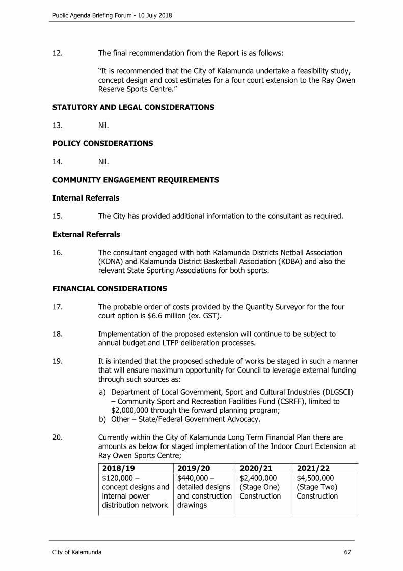
Public Agenda Briefing Forum - 10 July 2018
City of Kalamunda 67
12. The final recommendation from the Report is as follows:
“It is recommended that the City of Kalamunda undertake a feasibility study, concept design and cost estimates for a four court extension to the Ray Owen Reserve Sports Centre.”
STATUTORY AND LEGAL CONSIDERATIONS
13. Nil.
POLICY CONSIDERATIONS
14. Nil.
COMMUNITY ENGAGEMENT REQUIREMENTS
Internal Referrals
15. The City has provided additional information to the consultant as required.
External Referrals
16. The consultant engaged with both Kalamunda Districts Netball Association (KDNA) and Kalamunda District Basketball Association (KDBA) and also the relevant State Sporting Associations for both sports.
FINANCIAL CONSIDERATIONS
17. The probable order of costs provided by the Quantity Surveyor for the four court option is $6.6 million (ex. GST).
18. Implementation of the proposed extension will continue to be subject to annual budget and LTFP deliberation processes.
19. It is intended that the proposed schedule of works be staged in such a manner that will ensure maximum opportunity for Council to leverage external funding through such sources as:a) Department of Local Government, Sport and Cultural Industries (DLGSCI)
– Community Sport and Recreation Facilities Fund (CSRFF), limited to $2,000,000 through the forward planning program;
b) Other – State/Federal Government Advocacy.
20. Currently within the City of Kalamunda Long Term Financial Plan there are amounts as below for staged implementation of the Indoor Court Extension at Ray Owen Sports Centre;2018/19 2019/20 2020/21 2021/22$120,000 – concept designs and internal power distribution network
$440,000 – detailed designs and construction drawings
$2,400,000(Stage One)Construction
$4,500,000(Stage Two)Construction

Public Agenda Briefing Forum - 10 July 2018
City of Kalamunda 68
21. Contributions from both KDNA and KDBA could also be potentially considered, as per previous large scale projects undertaken at the centre.
STRATEGIC COMMUNITY PLAN
Strategic Planning Alignment
22. Kalamunda Advancing Strategic Community Plan to 2027
Priority 1: Kalamunda Cares and InteractsObjective 1.2 - To provide a safe and healthy environment for community to enjoy.Strategy - 1.2.3 Provide high quality and accessible recreational and social spaces and facilities. Strategy 1.2.2 - Advocate and promote healthy lifestyle choices by encouraging the community to become more physically active.
Priority 1: Kalamunda Cares and InteractsObjective 1.3 - To support the active participation of local communities.Strategy 1.3.1 - Support local communities to connect, grow and shape the future of Kalamunda.
Priority 3: Kalamunda DevelopsObjective 3.2 - To connect community to quality amenities.Strategy 3.2.1 - Optimal management of all assets.
SUSTAINABILITY
Social Implications
23. Department of Local Government, Sport and Cultural Industries (DLGSCI) advocates and supports projects to strengthen communities through sport and recreation. The proposed provision of four additional indoor courts at the Ray Owen Sports Centre will provide greater opportunity for more people to take part in physical activity, promoting a healthier community and enhancing cognitive function in children.
Economic Implications
24. Nil
Environmental Implications
25. Further adoption of modern technology, sustainable building materials and efficient power and water supplies, will have a long term positive impact on the environment.

Public Agenda Briefing Forum - 10 July 2018
City of Kalamunda 69
RISK MANAGEMENT CONSIDERATIONS
26. Risk: Insufficient funding available to develop an additional four courts resulting in people being unable to play their desired sport.
Likelihood Consequence RatingPossible Significant HighAction/StrategyProject to remain a high priority in all future advocacy programs to help secure significant external funding.
Risk: Without the Report, the City’s approach to upgrade would be adhoc and nor would it be able to advocate effectively for external funding.
Likelihood Consequence RatingPossible Moderate MediumAction/StrategyTo progress the Report to ensure upgrades are planned effectively and advocacy opportunities are maximised.
Risk: The Report may raise community expectations for improvements that may not be affordable in the near future
Likelihood Consequence RatingPossible Moderate MediumAction/StrategyEnsure community is informed as part of the communications process that improvements are subject to external funding and budget availability.
Risk: Four courts are developed and then underutilised.
Likelihood Consequence RatingUnlikely Moderate LowAction/StrategyThe Concept Design and Feasibility Study stages will enable objective decisions to be made regarding size, usage, functionality and affordability.
OFFICER COMMENT
27. The review of the proposed court redevelopment identifies that the demand for extra indoor court facilities at Ray Owen Sports Centre is still strong.
28. KDNA has advised that an estimated 600 people per week are being turned away during peak season and with a further 1,000 people missing out each season through lost opportunities to host large carnivals due to current usage at weekends.

Public Agenda Briefing Forum - 10 July 2018
City of Kalamunda 70
29. With no capacity to expand competitions or the number of teams playing, KDBA are finding that they often have an uneven number of teams within leagues. This uneven number of teams leads to byes each week, which could be alleviated by additional court space.
30. KDBA are also having to utilise satellite courts to provide training options for some teams due to demand and lack of availability at the centre. This is an additional cost that then goes to external providers rather than stay within Ray Owen Sports Centre.
31. The population of the City of Kalamunda is projected to grow by an estimated 16,838 by 2036. In the RORMP, the participation rates of residents for both basketball and netball within the City were identified as:a) 1.9% of the City’s population play basketball;b) 2.7% of the City’s population play netball.
32. Using the above participation rates for both sports in the City Of Kalamunda that equates to:a) A potential extra 319 players or 45 teams for basketball by 2036;b) A potential extra 454 players or 56 new teams for netball by 2036.
These figures reflect the continuing growth in both sports and the rising demand for facilities to accommodate the growth.
33. In regard to the State Sporting Associations strategic direction, the report notes that Netball WA identifies the City of Kalamunda as one of their priority development areas within the “Urban Growth Corridor”.
34. Basketball WA also report that within the Metropolitan area, demand is high for access to courts for training and that the likely future growth for basketball will focus on enhancing and extending indoor provision.
35. It is recommended within the report that the City undertake a feasibility study, concept design and cost estimates for a four court option. These are key elements to have in place when seeking external funding through DLGSCI’s Community Sport and Recreation Facility Fund Forward Planning grants.The feasibility study will help refine the concept and then test that concept to determine if it will perform both practically and financially.
36. This documentation will also be required when seeking other external grant funding and will enhance the City’s advocacy program opportunities.

Public Agenda Briefing Forum - 10 July 2018
City of Kalamunda 71
Voting Requirements: Simple Majority
RECOMMENDATION
That Council:
1. RECEIVES the Ray Owen Sports Centre Court Redevelopment Review report.
2. SUPPORTS the preferred option to develop four additional indoor courts at the Ray Owen Sports Centre.
3. REQUESTS the Chief Executive Officer to prepare concept designs, cost estimates and a feasibility study.

Public Agenda Briefing Forum - 10 July 2018
City of Kalamunda 72
11. Closure
There being no further business, the Presiding Member declared the Meeting closed at 8:05pm.
I confirm these Minutes to be a true and accurate record of the proceedings of this Council.
Signed: Presiding Member
Dated this day of 2018.