Provincial Overview - WildlifeCampus · N5 The national road between Kwa-Zulu Natal, Free State and...
16
Cultural Guiding Free State Course Provincial Overview © & 1 Module # 1 – Component # 1 Provincial Overview Introduction The Free State is known as South Africa's ‘breadbasket’ or ‘granary of the country’ and more than 30,000 farms produces over 70% of the country's grain. The province also boasts, among others productive gold and diamond mines, majestic sandstone mountains and archaeological and paleontological treasures. To the local rugby supporter this is ‘Cheetah country’! The landscape is characterised by the grassy plains of South Africa’s interior plateau. This is South Africa’s geographical heart, caught up between the Vaal and Orange Rivers. It is landlocked by KwaZulu Natal, Mpumalanga, Gauteng, North West, the Eastern Cape and Northern Cape. The neighbouring Lesotho fits in the hollow of the province’s bean- like shape. The current borders date from 1994 when the Bantustans were abolished and included into the provinces of South Africa. It is the only Province of the former provinces of South Africa which did not undergo border changes (excluding the incorporation of the Qwa-Qwa Bantustan). The Republic of the Orange Free State (Afrikaans: Oranje-Vrystaat; Dutch: Oranje- Vrijstaat) was an independent Boer republic in southern Africa during the second half of the 19th century. After the Second Anglo Boer War (Great South African War) it was a British colony for a short period, until 1910 when it became one of the four provinces of the Union of South Africa. In 1995, it became known as the Free State Province, one of the nine provinces of South Africa under the new dispensation. In Sesotho the province is known as Foreistata or Foreisetata.
Transcript of Provincial Overview - WildlifeCampus · N5 The national road between Kwa-Zulu Natal, Free State and...

Cultural Guiding Free State Course
Provincial Overview
© &
1
Module # 1 – Component # 1
Provincial Overview Introduction The Free State is known as South Africa's ‘breadbasket’ or ‘granary of the country’ and more than 30,000 farms produces over 70% of the country's grain. The province also
boasts, among others productive gold and diamond mines, majestic sandstone mountains and archaeological and paleontological treasures. To the local rugby
supporter this is ‘Cheetah country’!
The landscape is characterised by the grassy plains of South Africa’s interior plateau. This is South Africa’s geographical heart, caught up between the Vaal and Orange Rivers. It is landlocked by KwaZulu Natal, Mpumalanga, Gauteng, North West, the
Eastern Cape and Northern Cape. The neighbouring Lesotho fits in the hollow of the province’s bean- like shape.
The current borders date from 1994 when the Bantustans were abolished and included
into the provinces of South Africa. It is the only Province of the former provinces of South Africa which did not undergo border changes (excluding the incorporation of the
Qwa-Qwa Bantustan).
The Republic of the Orange Free State (Afrikaans: Oranje-Vrystaat; Dutch: Oranje-Vrijstaat) was an independent Boer republic in southern Africa during the second half of the 19th century. After the Second Anglo Boer War (Great South African War) it was
a British colony for a short period, until 1910 when it became one of the four provinces of the Union of South Africa. In 1995, it became known as the Free State Province, one
of the nine provinces of South Africa under the new dispensation. In Sesotho the province is known as Foreistata or Foreisetata.

Cultural Guiding Free State Course
Provincial Overview
© &
2
Coat of Arms
Motto: Katleho ka kopano
English: "Prosperity through unity"
The new coat of arms consists of the following elements:
In the centre of the shield is the indigenous Orange River Lily (Crinum Bulbispernum.)
The blue and green shield symbolises the green grasslands and the blue skies of the
province.
The sandstone formations of the Eastern Free State are represented by the top of the
yellow shape.
The shield is supported by two cheetahs.
The crown on top of the shield consists of diamonds, mealie (maize)-cobs and ears of
corn. These also bear witness to the agricultural and mining heritage of the province. The earth of the Free State State is portrayed by the base of the coat of arms

Cultural Guiding Free State Course
Provincial Overview
© &
3
Demographics
Surface area 3rd largest province
129 825km2 (Census 2011); 129 824 (Census 2001)
% of total area 10,6%
Population Second lowest population
2 745 590 (Census 2011)
2 786 800 (Midyear estimates 2014)
2,773,059 (Community Survey 2007)
Languages Census 2011
Sesotho 64.2%
Afrikaans 12.7%
isiXhosa 7.5%
Setswana 5.2% English 4.4%
Races Census 2011
Black 87.6%
White 8.7%
Coloured 3.1% Indian/Asian 0.4%
Unemployment
rate
Labour survey
33% (Q4:2013)
33.7% (Q3:2013)
32,7% (Q3: 2012) 25.5% (Q3: 2011)
Capital Bloemfontein
Largest city Bloemfontein
Premier Mr. Sekgobelo Elias Magashule (ANC)
He is the longest serving Provincial Chairperson in the
country.
He has led the ANC in the Free State for over 12 years.
Went into exile in 1989 and return in 1991. Previously: Beatrice Marshoff (ANC)

Cultural Guiding Free State Course
Provincial Overview
© &
4
Geographical Features of the Landscape
The Free State is situated on flat boundless plains in the heart of South Africa. Most of
the province is about 1000 meters above sea level, but the Drakensberg and Maluti
Mountains foothills reaches 2000m in the east.
The West stretches across savannah land and substantial mineral wealth, while the highlands of the east are dominated by mountain-tops. To the south it falls within the
true Karoo semi-desert.
The Free State lies in the heart of the Karoo Sequence of rocks, containing shales, mudstones, sandstones and the Drakensberg Basalt forming the youngest capping rocks.
The main rivers and dams
BOUNDARY RIVERS: Vaal and Orange
Vaal River Vaal Dam Bloemhof Dam Defines the border between the Free State and
Gauteng, as well as the one with North West.
Orange
River
Gariep (Xhariep) Dam
(Previously known as the
Hendrik Verwoerd Dam.
Defines the border between the Free State and
the Eastern and Northern Cape.
Cultural Guiding Free State Course
Provincial Overview
© &
5
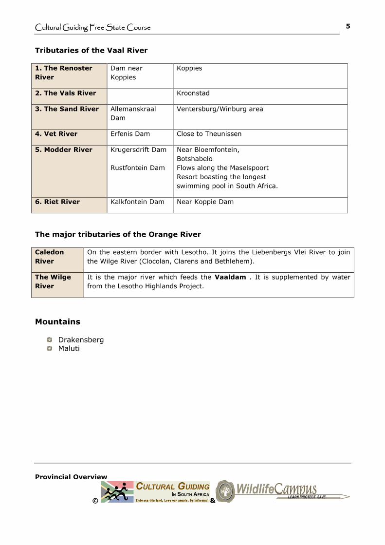
Tributaries of the Vaal River
1. The Renoster
River
Dam near
Koppies
Koppies
2. The Vals River Kroonstad
3. The Sand River Allemanskraal
Dam
Ventersburg/Winburg area
4. Vet River Erfenis Dam Close to Theunissen
5. Modder River Krugersdrift Dam
Rustfontein Dam
Near Bloemfontein,
Botshabelo
Flows along the Maselspoort
Resort boasting the longest
swimming pool in South Africa.
6. Riet River Kalkfontein Dam Near Koppie Dam
The major tributaries of the Orange River
Caledon
River
On the eastern border with Lesotho. It joins the Liebenbergs Vlei River to join
the Wilge River (Clocolan, Clarens and Bethlehem).
The Wilge
River
It is the major river which feeds the Vaaldam . It is supplemented by water
from the Lesotho Highlands Project.
Mountains
Drakensberg Maluti
Cultural Guiding Free State Course
Provincial Overview
© &
6
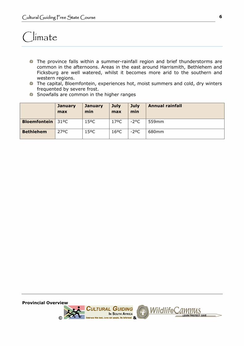
Climate
The province falls within a summer-rainfall region and brief thunderstorms are
common in the afternoons. Areas in the east around Harrismith, Bethlehem and
Ficksburg are well watered, whilst it becomes more arid to the southern and western regions.
The capital, Bloemfontein, experiences hot, moist summers and cold, dry winters
frequented by severe frost. Snowfalls are common in the higher ranges
January
max
January
min
July
max
July
min
Annual rainfall
Bloemfontein 31ºC 15ºC 17ºC -2°C 559mm
Bethlehem 27ºC 15ºC 16ºC -2ºC 680mm

Cultural Guiding Free State Course
Provincial Overview
© &
7
Nature and Conservation
World Hertiage Site
VERDEFORT METEORITE IMPACT CRATER (Vredefort dome )
National Parks
Golden Gate Higjlands National Park
Ramsar Wetland Site
Seekoeivlei Nature Reserve
Other interestin Nature Reserves
Platberg
Sand River
Willem Pretorius
Tussen die Twee Riviere
Rustfontein
Xhariep Dam
Cultural Guiding Free State Course
Provincial Overview
© &
8
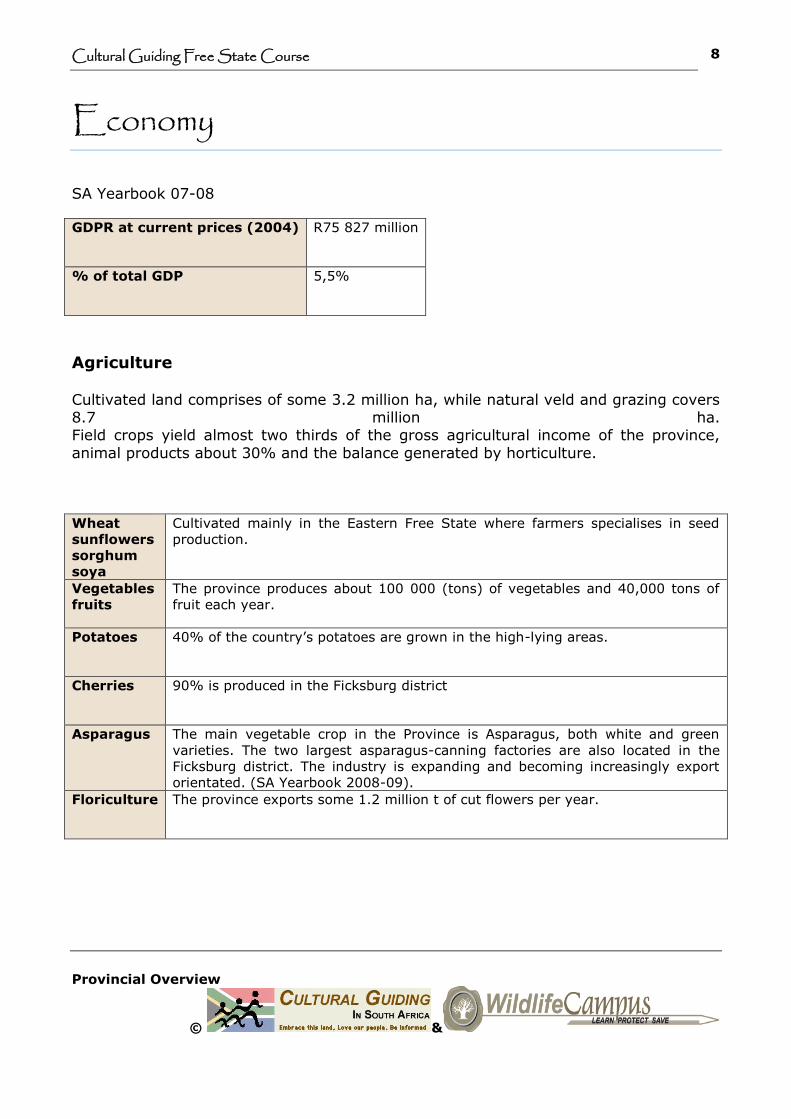
Economy
SA Yearbook 07-08
GDPR at current prices (2004) R75 827 million
% of total GDP 5,5%
Agriculture
Cultivated land comprises of some 3.2 million ha, while natural veld and grazing covers 8.7 million ha. Field crops yield almost two thirds of the gross agricultural income of the province,
animal products about 30% and the balance generated by horticulture.
Wheat
sunflowers
sorghum
soya
Cultivated mainly in the Eastern Free State where farmers specialises in seed
production.
Vegetables
fruits
The province produces about 100 000 (tons) of vegetables and 40,000 tons of
fruit each year.
Potatoes 40% of the country’s potatoes are grown in the high-lying areas.
Cherries 90% is produced in the Ficksburg district
Asparagus The main vegetable crop in the Province is Asparagus, both white and green
varieties. The two largest asparagus-canning factories are also located in the
Ficksburg district. The industry is expanding and becoming increasingly export
orientated. (SA Yearbook 2008-09).
Floriculture The province exports some 1.2 million t of cut flowers per year.

Cultural Guiding Free State Course
Provincial Overview
© &
9
Mining
The Free State contributes about 16% of South Africa’s mineral output. The mining
industry is the largest employer in the Province.
Goldfields stretch for approximately 400km across Gauteng, North West and the Free State and is collectively known as the ‘Golden arch’. Free State Consolidated Goldfields is the largest gold-mining complex with a mining area of approximately 33 000 ha.
Harmony Gold Refinery (Free State) and Rand Refinery (Gauteng) are the only two gold refineries in the country that may market gold on behalf of the South African
Reserve Bank.
Gold The main gold-mining districts are Odendaalsrus, Virginia and Welkom.
Roughly 30% of South Africa’s gold is derived from this region.
Silver The gold mines also supply a significant portion of the total silver production of the country.
Uranium Acquired as a by-product of gold-mining.
Bituminous
coal
Mined in the province and converted into petrochemicals at Sasolburg.
Diamonds High quality diamonds are extracted from kimberlite pipes and fissures.
Bentonite The largest deposit in the cou ntry is found in the Koppies district.

Cultural Guiding Free State Course
Provincial Overview
© &
10
Manufacturing
Some 14% of the province’s manufacturing is classified as being in high-technology
industries, which is the highest percentage of all the provincial economies.
Textiles Farm machinery and equipment Leather tanning and finishing
Gold Jewellery Petrochemicals include fuels, waxes and polymers.
Liquid Petroleum Gas (LPG) – gas supply to City of Johannesburg. Floriculture - the province exports some 1,2 million tons of cut flowers per year.
Biofuel plants - In 2006 Ethanol Africa announced its plans to build maize-to-ethanol plants in South Africa. The cost is an estimated $1 billion. The company planned to build eight biofuels plants near Bothaville. Construction was however
put on hold to assess funding options and government support. (Science in Africa, November 2008).
NATREF = major inland refinery. Mainly aircraft fuel and diesel.
Tourism
The prime tourist attraction in the province is the Golden Gate Highlands National Park, located at the foothills of the Maluti Mountains in the north-eastern Free State.

Cultural Guiding Free State Course
Provincial Overview
© &
11
Biofuel plants - In 2006 Ethanol Africa announced its plans to build maize-to-
ethanol plants in South Africa. The cost is an estimated $1 billion. The company planned to build eight biofuels plants near Bothaville. Construction was
howeverput on hold to assess funding options and government support. (Science in Africa, November 2008).
NATREF = major inland refinery. Mainly aircraft fuel and diesel.
Manufacturing
Some 14% of the province’s manufacturing is classified as being in high-technology
industries, which is the highest percentage of all the provincial economies.
Textiles
Farm machinery and equipment Leather tanning and finishing
Gold Jewellery Petrochemicals include fuels, waxes and polymers. Liquid Petroleum Gas (LPG) – gas supply to City of Johannesburg.
Floriculture - the province exports some 1,2 million tons of cut flowers per year.

Cultural Guiding Free State Course
Provincial Overview
© &
12
Infrastructure
The road network density of the Free State is the third highest in the country
and well signposted. Main roads are tarred but some of the smaller country
routes are connected by well maintained gravel roads. Caution should be taken while driving on gravel roads.
Bloemfontein has an airport located in the east about 10km from the city centre.
Airports: Bloemfontein and Harrismith.

Cultural Guiding Free State Course
Provincial Overview
© &
13
Main Routes
National Roads
N1 Links Gauteng, the Western and Eastern Cape and cuts through the middle of the Free
State.
N3 Serves as a major link between Kwa-Zulu Natal and Gauteng via Harrismith.
N5 The national road between Kwa-Zulu Natal, Free State and Western Cape, also via
Harrismith.
N6 See below
Free State Tourist Routes
‘The Friendly
N6’
Also known as “the value for money” route. The route links Bloemfontein with
East London in the Eastern Cape. It offers a wide array of attractions such as
art galleries, community projects, the Drakensberg Mountains, natural hot
springs and farm stays.
Maluti Route Scenic drive through the Highlands of the Free State and across the border to
Lesotho and its magnificent Maluti Mountains. The route finally reaches the
RAMSAR accredited Seekoeivlei Nature Reserve at Memel.
Goldfields
Route
Explore the gold mining history within the Lejweleputswa district.
BBT Heritage
Route
Explore the diverse cultural and political heritage of Bloemfontein, Botshabelo
and Thaba Nchu.
Diamond and
Wine Route
This follows in the diamond prospectors of the past and present. At
Jagersfontein the 760m man-made diamond hole rivals that of the better
known Big Hole of Kimberley for size. The Jacobsdal area offers visits to wine
cellars.

Cultural Guiding Free State Course
Provincial Overview
© &
14
About the Free State course
Course Description: Cover the Provincial, Cultural, Historical and Natural Overview
for the province, as well as all the cities and towns according to the District
municipalities. It also includes information about the origin and history of the towns,
the origin and meaning of place names, claims to fame, economical activities, sites,
attractions and things to do.
Important notice: This is only a theoretical course and does not automatically qualify
the student as a tourist guide for the Free State Province.
Assessment to qualify as a Free State Provincial guide
Apply to Makiti Guides & Tours (an accredited Cathsseta Provider 613/P/060074/2006)
for assessment.
Qualification requirements for provincial courses
The National Certificate in Tourism: Guiding NQF L4 (20155) or FETC: Tourist guiding NQF L4 (71549). A copy of the Theta/Cathsseta certificate will be
required as proof. (A skills certificate will not be acceptable). Level I first aid certificate
Registered Culture Provincial Guides with the relevant qualifications (see
above):
Can proceed immediately with assessment involving assignments and a knowledge questionnaire.
Registered Nature Guides:
First needs to complete a bridging course to obtain the FETC: Tourist guiding NQF L4
(71549) certificate. This will partly involve Recognition for prior learning (RPL).
Candidates wishing to become a Culture Provincial Guide:
Enrol for the FETC: Tourist Guiding NQF L4 (Basics & Advanced courses). The latter will include the assessment for the province.
Contact us for any further information
Tel. 012 347 6001
Email: [email protected]

Cultural Guiding Free State Course
Provincial Overview
© &
15
Resources and further reading
Explorer Map South Africa Eastern Cape. Randbird Publishers. 2003.
The Friendly N6. Bloemfontein to East London
The South African National Roads Agency Ltd (SANRAL) map
Websites
www.fs.gov.za
www.fsl.gov.za
www.geoscience.org.za
www.motheo.co.za
www. sanparks.org
www.scienceinafrica.co.za
www.wikipedia.org
Bulpin, TV. Majestic South Africa – Land of Splendour and beauty. Reader’s Digest
Association.1999.
Department of Agriculture, Northern Cape.
Lbour Survey 2007, 2008)
SA Yearbook 2007-2008: 2008-2009
South Africa at a Glance 2009-2010
The Tourism Blueprint Reference Guide to the Nine Provinces of South Africa including Swaziland & Lesotho. Tourism Blueprint. 2006.
Brochures and maps
Discover South Africa’s Free State and rediscover your soul. Free State Tourism.

Cultural Guiding Free State Course
Provincial Overview
© &
16
www.motheo.co.za/tourism/pdf/trade_doingbusiness.pdf
Compiled by ML Kruger and M.Barnard (2009)
Oral resources
JJ Kruger, Civil Engineer
CJH Steenkamp. SASOL
Practical Exploration
Makiti Guides & Tours (Pty) Ltd. August 2008
Photos
ML Kruger - Makiti Guides & Tours (Pty) Ltd. August 2008