Providing Data to Support the Net Gain Approach...NPPF Paragraph 170. Planning policies and...
18
Thames Valley Environmental Records Centre Providing Data to Support the Net Gain Approach Dan Carpenter 3 rd December 2019
Transcript of Providing Data to Support the Net Gain Approach...NPPF Paragraph 170. Planning policies and...

Thames Valley
Environmental Records Centre
Providing Data to Support the Net Gain ApproachDan Carpenter 3rd December 2019

Data to support net gain

Outline
1. Brief look at the NPPF2. Setting standards3. Baseline data4. Offset registers5. Monitoring6. Reporting7. Other services8. Ecological networks & NRNs9. ALERC10. Summary

NPPF
Paragraph 170. Planning policies and decisions should contribute to and enhance the natural and local environment by: d) minimising impacts on and providing net gains for biodiversity, including by
establishing coherent ecological networks that are more resilient to current and future pressures;
Paragraph 174. To protect and enhance biodiversity and geodiversity, plans should: b) promote the conservation, restoration and enhancement of priority
habitats, ecological networks and the protection and recovery of priority species; and identify and pursue opportunities for securing measurable net gains for biodiversity.
Paragraph 175. When determining planning applications, local planning authorities should apply the following principles: d) development whose primary objective is to conserve or enhance
biodiversity should be supported; while opportunities to incorporate biodiversity improvements in and around developments should be encouraged, especially where this can secure measurable net gains for biodiversity.

Data standards
Standards mean net gain assessments are:
Transparent
Reproducible
Repeatable
Discussion on habitat condition standards: https://tinyurl.com/sb96dg3

Baseline data
Highest value for priority habitat within designated sites
Landscape view of habitats and areas of importance
Habitat distinctiveness map for Berkshire and Oxfordshire

Baseline data
Seamless mapping
3,688,961 polygons
141 habitat/land-use
types
21% of Hampshire is
recorded as Priority
Habitat of which 72%
lies within SSSIs and
SINCs
HBIC’s habitat mapping – Priority habitats

Offset site register
Register:
• Site location
• Proposed habitat
• Baseline habitat and
condition
• Monitoring data

Monitoring
Site monitoring:
• Habitat type and condition
• Repeated observations to inform
management
Traditional botanical/habitat survey
Exploring new technology for rapid
assessment
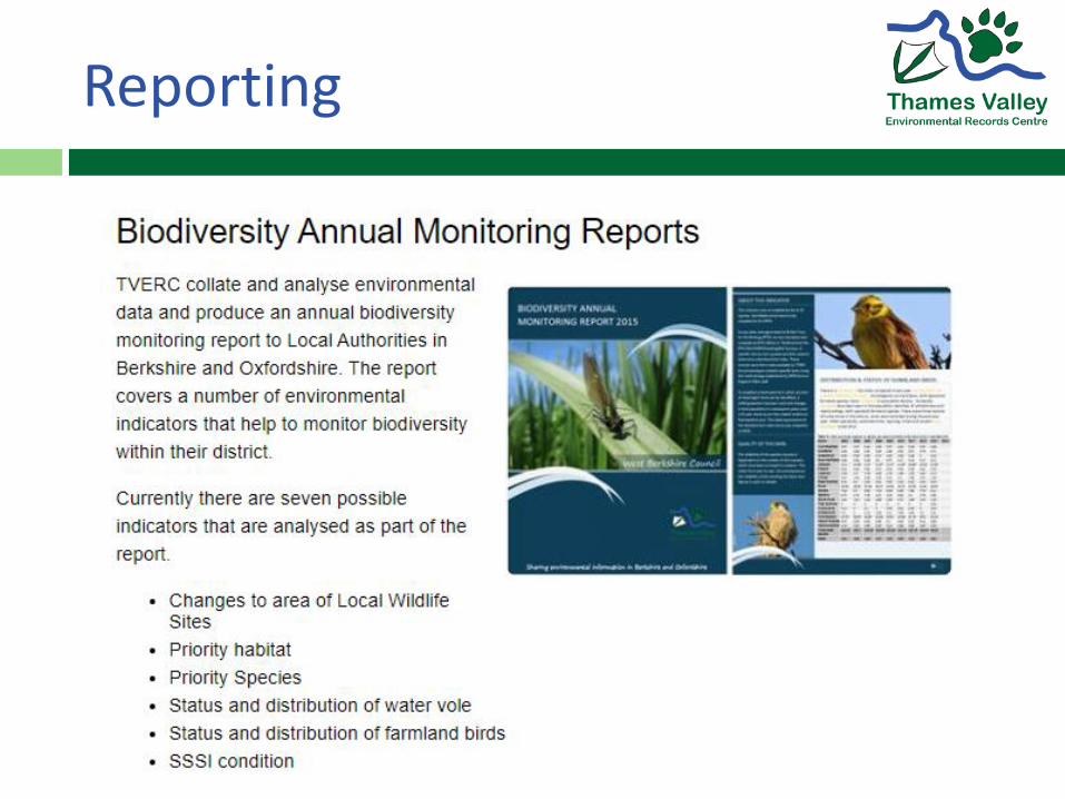
Reporting

Reporting
LERCs already reporting on biodiversity indicators
E.g. Annual Monitoring Reports, SDL160 indicator
Reporting on net gain is a natural extension

Net gain assessments
0
1000
2000
3000
4000
5000
6000
7000
Pre-development Post-development
Biodiversity units
West Berkshire Local Plan Sites
• Forecast loss of between 2,379
and 13,577 units
• Net biodiversity loss value
between £21 million and £200
million

Support for LPAs
West Oxfordshire District Council
Training on metric and net gain assessment
Carrying out assessments at application stage

Ecological networks
Hampshire
Ecological Network:
• Core Statutory
Sites,
• Core Non-
statutory Sites,
• Network
Opportunities

Nature Recovery Network
Draft NRN for Oxfordshire:
Core Areas
Potential Areas
Wider Landscape
Work to commence shortly in Berkshire

Tools and standards
ALERC provides an accreditation scheme for LERCs
Develop accreditation to incorporate standards
Deliver a local service to meet LPA needs

Summary
LERCs are impartial – so is their data
ALERC is leading work to set and raise standards, both for data and for LERCs
LERCs hold key data that you need to deliver biodiversity net gain
Many LPAs already work with LERCs – partnership is key to successful delivery