PROTECTING POPULATIONS FROM TRAFFIC -RELATED AIR … · accountable to the public (RPP) WHAT IS...
62
PROTECTING POPULATIONS FROM TRAFFIC-RELATED AIR POLLUTION THROUGH PARTNERSHIPS WITH PLANNING PROFESSIONALS “A planner’s perspective” March 22, 2018
Transcript of PROTECTING POPULATIONS FROM TRAFFIC -RELATED AIR … · accountable to the public (RPP) WHAT IS...

PROTECTING POPULATIONS FROM TRAFFIC-RELATED AIR POLLUTION THROUGH PARTNERSHIPS WITH PLANNING PROFESSIONALS “A planner’s perspective”
March 22, 2018
ONTARIO PROFESSIONAL PLANNERS INSTITUTE recognized voice of the Province’s planning profession 4,500 members in public and private sectors in fields of urban and rural development, design, environment, transportation, health, social services, housing, etc. members held to practice requirements and accountable to the public (RPP)
WHAT IS PLANNING? Planning means the scientific, aesthetic, and
orderly disposition of land, resources, facilities and services with a view to securing the physical, economic and social efficiency, health and well-being of urban and rural communities. (Canadian Institute of Planners)

LET’S TALK POLICY! Some planner’s tools at provincial level:
• The PLANNING ACT is provincial regulation describing how land uses can be controlled and who may control them
• A PROVINCIAL POLICY STATEMENT is released time to time from the Minister of Municipal Affairs and Housing with matters related to land use planning of provincial interest
Section Title

LET’S TALK POLICY! Some planner’s tools at local level:
• OFFICIAL PLANS are found in your own community, setting out a region’s and/or town’s planning goals and policies
• ZONING BY-LAWS are rules and regulations controlling development
• ENVIRONMENTAL ASSESSMENTS are a planning and decision-making process used to promote environmentally responsible decision-making.
Section Title
AIR QUALITY + CLIMATE CHANGE… Needs to be part of a larger conversation “Promoting compact urban form and an energy efficient pattern and mix of land uses…” “Providing opportunities for the use of energy efficient transportation modes in order to minimize individual motor vehicle travel in favour of walking, cycling and transit.”

ZONING BY-LAWS Decision-making on what can be built
where – before it’s built! Can prescribe land use but not people Examples: Schools, playgrounds and
daycares, long-term health care facilities, hospitals, retirement homes
May include buffers

A study report for something to be built to be submitted to the Minister of Environment and Climate Change Examples include public roads and
highways, transit, waste management, water, etc. Environmental, i.e. air quality is often
included in studies (real, modelled, etc.)
ENVIRONMENTAL ASSESSMENTS

ADDRESSING TRAP IN PLANNING Where and when are the opportunities in
planning processes and deliverables? Buildings – spaces around buildings,
Building Code = design and interior, policy, site plan, approvals Roads – studies, design, plans, approvals Air – studies, methods, monitoring,
evaluation

IF PUBLIC HEALTH PROVIDES US THE DATA… - What is the context? How should it be used? Is it preventable? Is it too late? Mitigation? Preventative measures?

HOW DO WE ARRIVE AT THE “BEST” DECISION? - Data? Public interest? Transportation? Public Space? Public Health?
Place-making? Zoning? Living space? Politics? Economics? Costs? - To be continued…

POTENTIAL OPPORTUNITIES TRAPs needs to be part of a larger
conversation to be part of the agenda Educate planners and public about TRAPs Improve data collection to contribute in
planning processes, e.g. EAs Awareness of policies, jurisdiction, scale Consultation before something gets built is
key!
Thank you!
Darryl Young, RPP, MCIP [email protected]
References: Ontario Professional Planners Institute: http://ontarioplanners.ca/ Citizens' Guides to Land-use Planning: Ministry of Municipal Affairs City of Toronto - Reducing Health Risks from Traffic-Related Air Pollution
(TRAP) in Toronto

Protecting Populations From Traffic-Related Air Pollution Through Partnerships With Planning Professionals March 22, 2018, 1:00 PM – 2:30 PM
Elaina MacIntyre – Epidemiologist Specialist, Environmental & Occupational Health, Public Health Ontario
Sally Radisic – Health Hazards Specialist, City of Hamilton Public Health Services
Louise Aubin – Health Protection Manager, Peel Public Health
Kevin Haley – Environmental Health Specialist, York Region Public Health
Darryl Young – Transportation Working Group Chair, Planning Issues Strategy Group, Ontario Professional Planners Institute

DISCLOSURE OF COMMERCIAL SUPPORT
• None of the presenters at this session have received financial support or in-kind support from a commercial sponsor.
• None of the presenters have potential conflicts of interest to declare.
Traffic-related air pollution (TRAP): Background & PHO activities
Elaina MacIntyre
TOPHC 2018 - March 22, 2018
PublicHealthOntario.ca
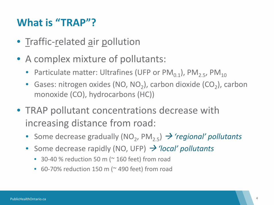
What is “TRAP”?
4
• Traffic-related air pollution
• A complex mixture of pollutants: • Particulate matter: Ultrafines (UFP or PM0.1), PM2.5, PM10 • Gases: nitrogen oxides (NO, NO2), carbon dioxide (CO2), carbon
monoxide (CO), hydrocarbons (HC))
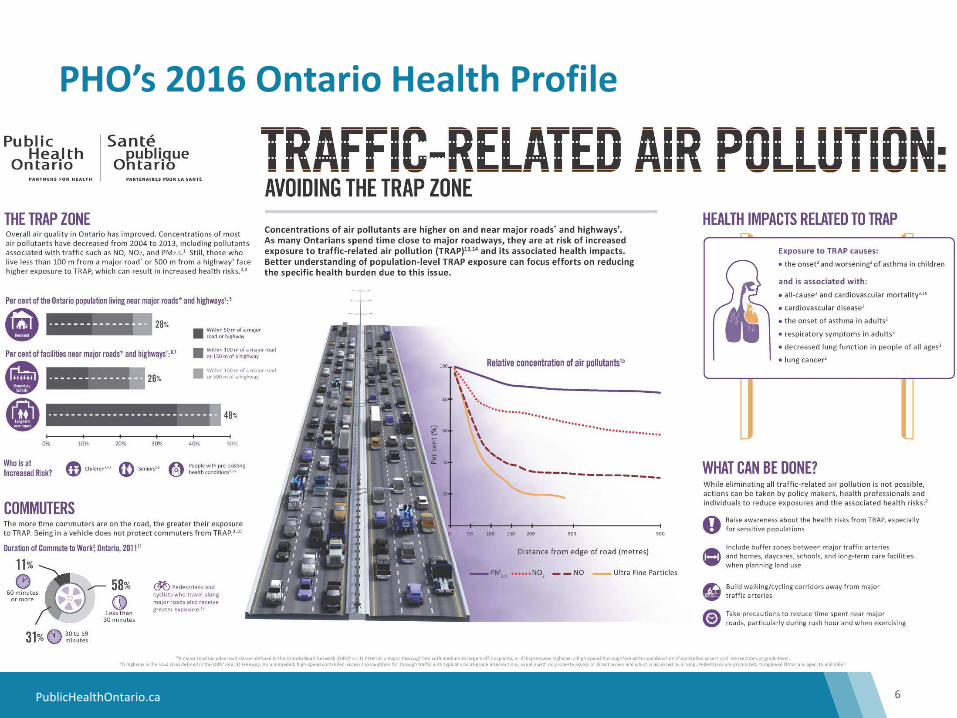
• TRAP pollutant concentrations decrease with increasing distance from road: • Some decrease gradually (NO2, PM2.5) ‘regional’ pollutants • Some decrease rapidly (NO, UFP) ‘local’ pollutants
• 30-40 % reduction 50 m (~ 160 feet) from road • 60-70% reduction 150 m (~ 490 feet) from road
PublicHealthOntario.ca
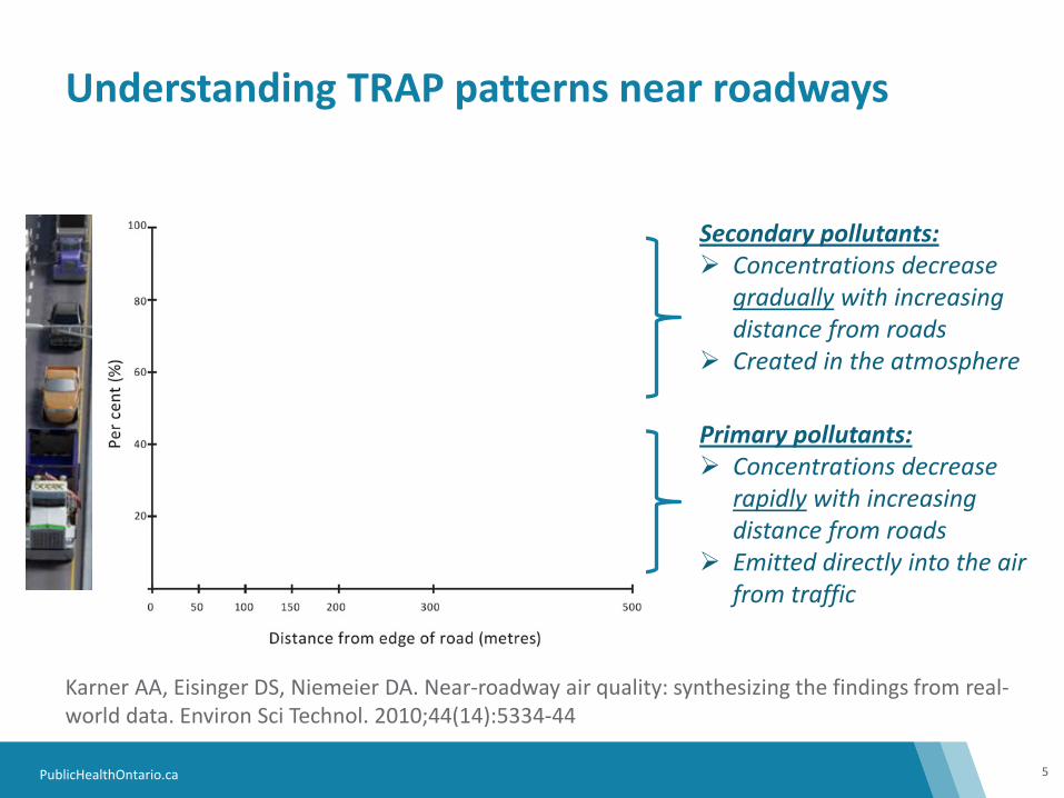
Understanding TRAP patterns near roadways
5
Karner AA, Eisinger DS, Niemeier DA. Near-roadway air quality: synthesizing the findings from real-world data. Environ Sci Technol. 2010;44(14):5334-44
Primary pollutants: Concentrations decrease
rapidly with increasing distance from roads
Emitted directly into the air from traffic
Secondary pollutants: Concentrations decrease
gradually with increasing distance from roads
Created in the atmosphere
PM2.5
NO2
NO
Ultra Fine Particles
PublicHealthOntario.ca
PHO’s 2016 Ontario Health Profile
6

PublicHealthOntario.ca
Defining a TRAP zone:
7
Areas most highly affected by traffic • 50 m of a major road or highway • 100 m of a major road or 150 m of a highway • 100 m of a major road or 500 m of a highway
PublicHealthOntario.ca
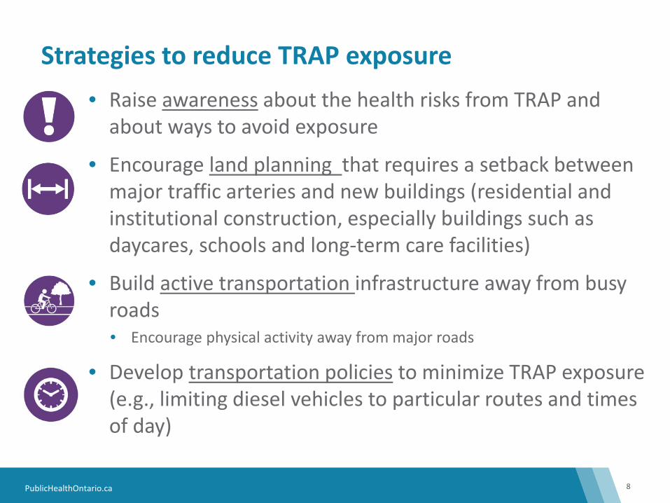
Strategies to reduce TRAP exposure
8
• Raise awareness about the health risks from TRAP and about ways to avoid exposure
• Encourage land planning that requires a setback between major traffic arteries and new buildings (residential and institutional construction, especially buildings such as daycares, schools and long-term care facilities)
• Build active transportation infrastructure away from busy roads • Encourage physical activity away from major roads
• Develop transportation policies to minimize TRAP exposure (e.g., limiting diesel vehicles to particular routes and times of day)

PublicHealthOntario.ca
PHO’s 2017 Jurisdictional Scan
9
• Scope: voluntary or legal actions with the intent to mitigate or reduce population exposure to TRAP that can be initiated or implemented by a land use planner. • Grey literature search performed by PHO library services • Identified 137 Canadian and 180 international resources
• Excluded: Recommendations which were not implemented (e.g., guidance), actions outside planning (i.e., anti-idling bylaws), and funding initiatives
PublicHealthOntario.ca
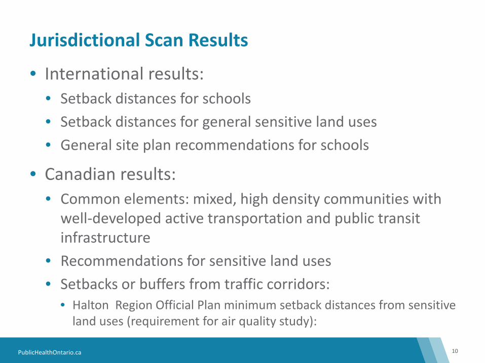
Jurisdictional Scan Results
10
• International results: • Setback distances for schools • Setback distances for general sensitive land uses • General site plan recommendations for schools
• Canadian results: • Common elements: mixed, high density communities with
well-developed active transportation and public transit infrastructure
• Recommendations for sensitive land uses • Setbacks or buffers from traffic corridors:
• Halton Region Official Plan minimum setback distances from sensitive land uses (requirement for air quality study):
TOPHC 2018
Healthy and Safe Communities
Hamilton Airshed Modelling System (HAMS)
Thursday March 22, 2018
Healthy Environments Division Sally Radisic, PhD
2
Healthy and Safe Communities Department Healthy Environments Division
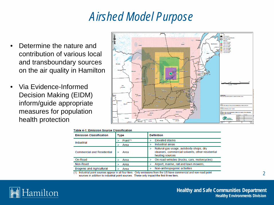
Airshed Model Purpose
• Determine the nature and contribution of various local and transboundary sources on the air quality in Hamilton
• Via Evidence-Informed
Decision Making (EIDM) inform/guide appropriate measures for population health protection
3
Healthy and Safe Communities Department Healthy Environments Divison
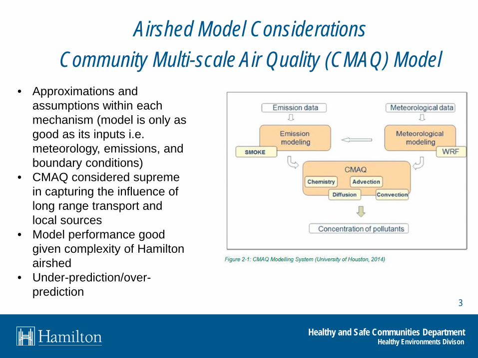
Airshed Model Considerations Community Multi-scale Air Quality (CMAQ) Model
• Approximations and assumptions within each mechanism (model is only as good as its inputs i.e. meteorology, emissions, and boundary conditions)
• CMAQ considered supreme in capturing the influence of long range transport and local sources
• Model performance good given complexity of Hamilton airshed
• Under-prediction/over-prediction

4
Healthy and Safe Communities Department Healthy Environments Divison
Observed vs Modelled Result

5
Healthy and Safe Communities Department Healthy Environments Division
Total Hamilton Emissions Profile
Industry
Commercial
Residential
Agricultural
On-Road
Non-Road
21%
1%
0.5%
3%
41%
34%
75% Transportation
6
Healthy and Safe Communities Department Healthy Environments Division
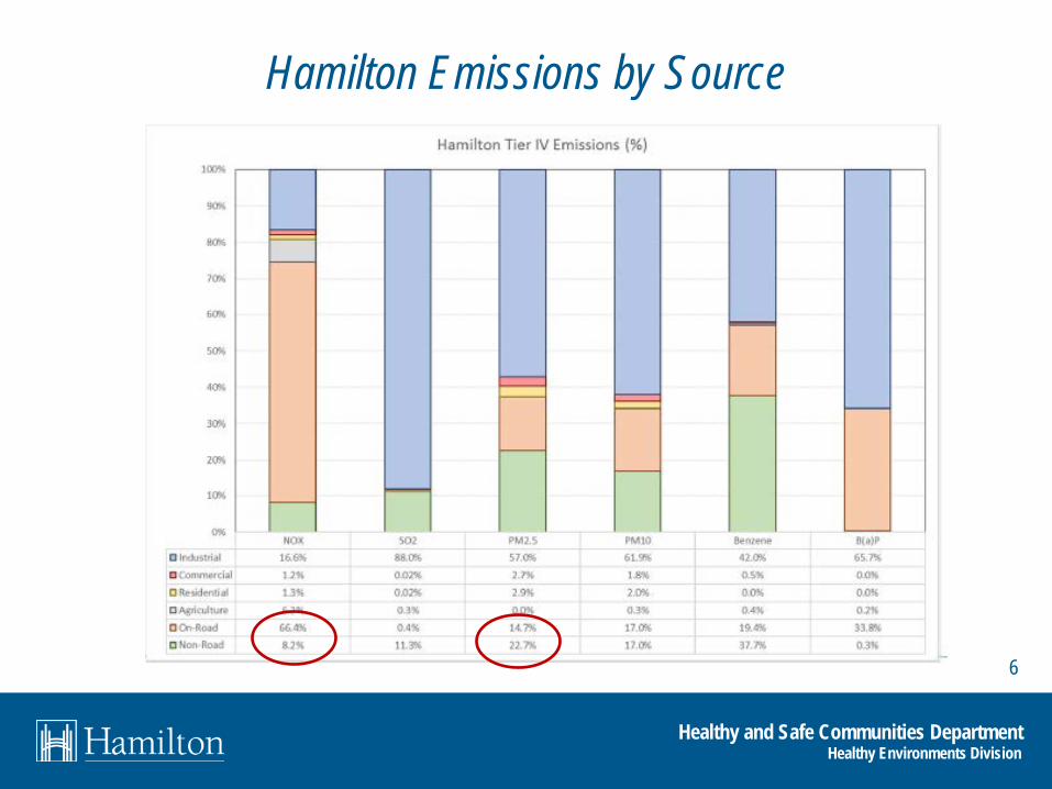
Hamilton Emissions by Source
7
Healthy and Safe Communities Department Healthy Environments Division
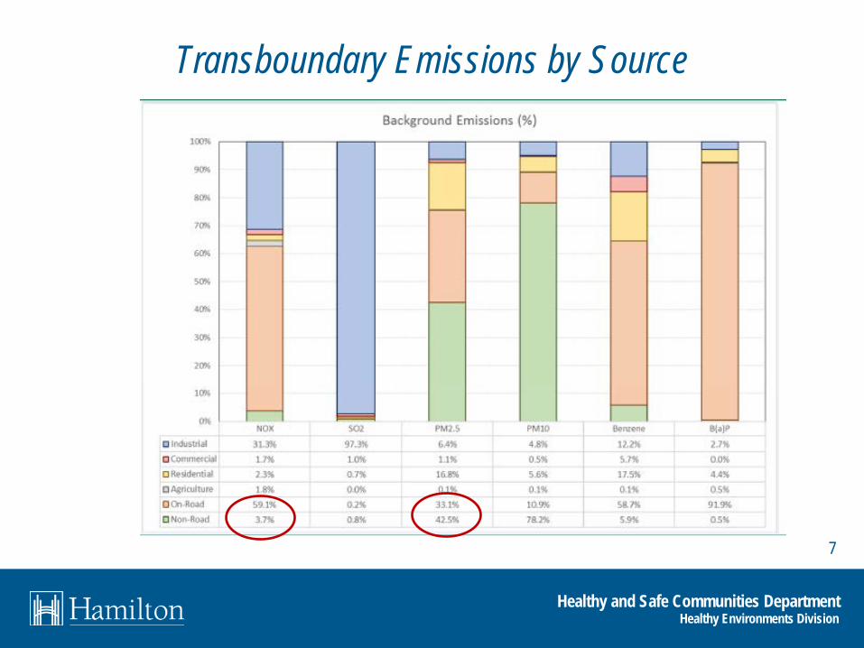
Transboundary Emissions by Source

8
Healthy and Safe Communities Department Healthy Environments Division
NO2
9
Healthy and Safe Communities Department Healthy Environments Division
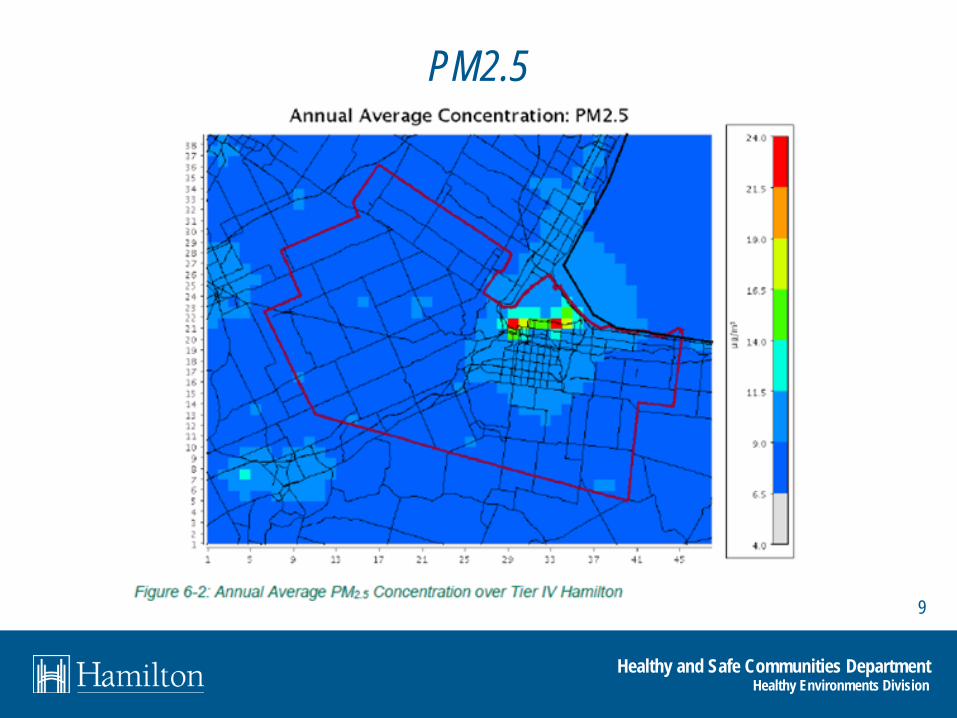
PM2.5

10
Healthy and Safe Communities Department Healthy Environments Division
Source Contribution

11
Healthy and Safe Communities Department Healthy Environments Division
Airshed Model Potential Applications
RECOMMENDATION 3 • Develop appropriate air
quality related guidelines for new and redeveloping neighbourhood land use planning
• These guidelines should consider the potential impacts of personal transportation, arterial roads, 400 series highways

12
Healthy and Safe Communities Department Healthy Environments Division
Airshed Model Risk Communication Seven Cardinal Rules of Risk Communication (Vincent Covello, EPA) 1. Accept and involve the public as a partner 2. Plan carefully and evaluate your efforts 3. Listen to the public’s specific concerns 4. Be honest, frank and open 5. Coordinate and collaborate with other credible sources 6. Meet the needs of the media 7. Speak clearly with compassion
13
Healthy and Safe Communities Department Healthy Environments Division
Thank you

Louise Aubin, Manager, Health Protection Region of Peel
Tackling TRAPs in Peel

Transportation in Region of Peel • $1.8 billion – goods
moved to, through and from Peel daily
• 68,000 vehicles move goods daily in Peel
• Pearson airport/rail intermodal yards
• Fifty percent of Peel residents live within 300m
• 103 schools, 175 licensed daycares, and 18 long-term care facilities are located within 300m of major roads

Official Plan – Air Quality Updated air quality policies, 2011 Co-led with Planning • Objectives
– To improve local air quality – To promote sustainable development and land use
patterns which address public health, transportation systems, energy conservation and environmental concerns
• 8 Policies – Monitor and model air quality to accurately establish
local air emissions in Peel and report on the findings from the modelling and monitoring.
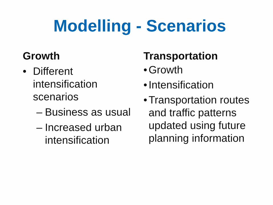
Modelling - Scenarios Growth • Different
intensification scenarios – Business as usual – Increased urban
intensification
Transportation •Growth • Intensification •Transportation routes and traffic patterns updated using future planning information
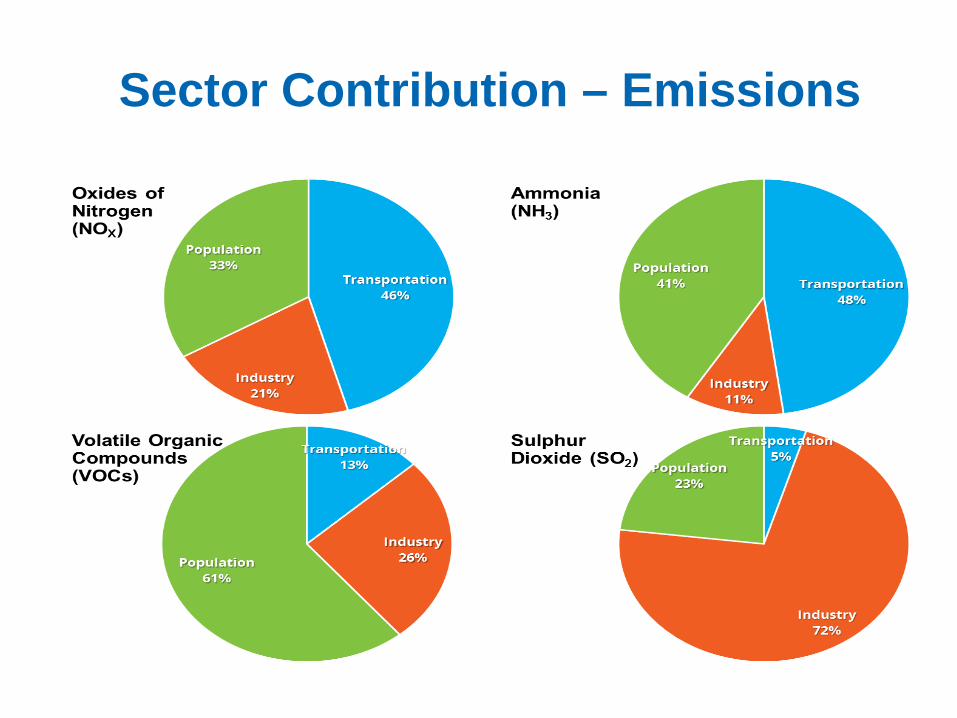
Sector Contribution – Emissions

Uses of the Data
• To inform discussions about the impact of growth and transportation on air quality
• To influence land-use and transportation plans (Official Plans,
long-range transportation, active transportation…)
• To inform Peel Public Health Work – Research
• Effective Interventions to Mitigate Adverse Human Health Effects from Transportation-Related Air and Noise Pollution

Peel Public Health - TRAPs
• Review and comments on: – Provincial policies – Growth management – RoP Official Plan – Long Range
Transportation Plan – Sustainable
Transportation Strategy – Goods movement
(limited)

Shopping list: Opportunities to Mitigate TRAPs
• Development of mixed, high-density communities – Increased walkability – Public transit and
commuter programs • Influencing plans:
– Transportation master plans
– Transportation demand management
– Active transportation • Siting of sensitive land
uses
• Influencing by-laws: – Limits on truck traffic to
specific routes/times – Anti-idling by-laws – Zoning
• Transportation pricing • Electric vehicle
infrastructure • Parking zones, HOV lanes • Building designs • Physical barriers – noise
walls, vegetation
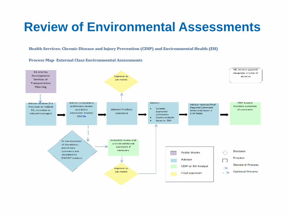
Review of Environmental Assessments

Partnerships and Collaboration - Key
• PPH – Chronic Disease and Injury Prevention staff
• PHUs – TRAP Working Group • Planners • Transportation Planners • Area municipalities

Addressing Traffic Related Air Pollutants in York Region
Kevin Haley, B.A.Sc.(EH),CPHI(C) Environmental Health Specialist
Health Protection Division
TOPHC March 22nd, 2018

2
York Region
The picture: • 1.2 million residents • Rapid growth. Population
expected to grow to 1.5 million residents by 2031
• 9 municipalities • Urban & rural communities
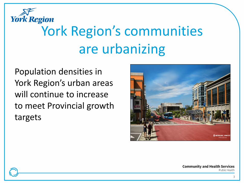
York Region’s communities are urbanizing
Population densities in York Region’s urban areas will continue to increase to meet Provincial growth targets
3
4
Public Health’s Involvement on the Built Environment & TRAPs
• Provincial legislation/policy e.g. Provincial Policy Statement, Coordinated Review of Land Use Plans, Cycle On 2.0
• Regional and municipal land use planning policies e.g. Official Plans
• Regional and municipal master plans e.g. Transportation Master Plan • Development applications and studies e.g. air quality assessments • Environmental Assessments: e.g. highway projects • Regional Committees: e.g. Strategic Opportunities for Integrating
Health & Transportation; Advancements in Transportation Technology Strategy; Active & Safe Routes to School

Policy Examples Addressing TRAPs
5
6
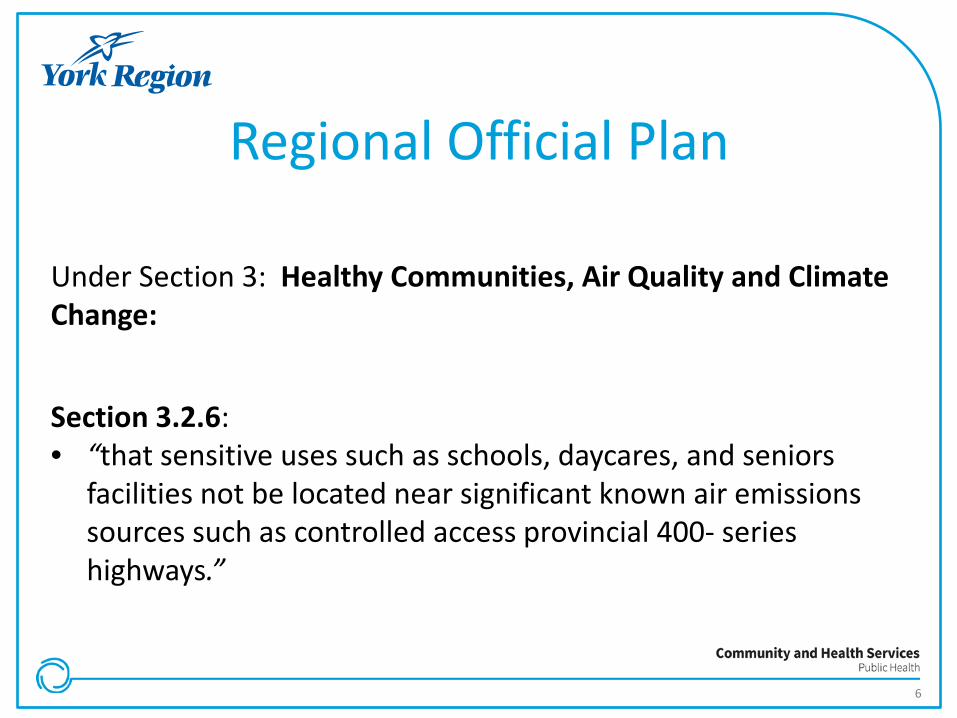
Regional Official Plan
Under Section 3: Healthy Communities, Air Quality and Climate Change: Section 3.2.6: • “that sensitive uses such as schools, daycares, and seniors
facilities not be located near significant known air emissions sources such as controlled access provincial 400- series highways.”

7
Mapping Built Environment Indicators PURPOSE: To determine the feasibility of mapping indicators for program planning and evaluation purposes Indicators GIS mapped included: • Sensitive uses in proximity to
roads with 100,000 AADT
• Sensitive uses in proximity from roads with 30,000 AADT

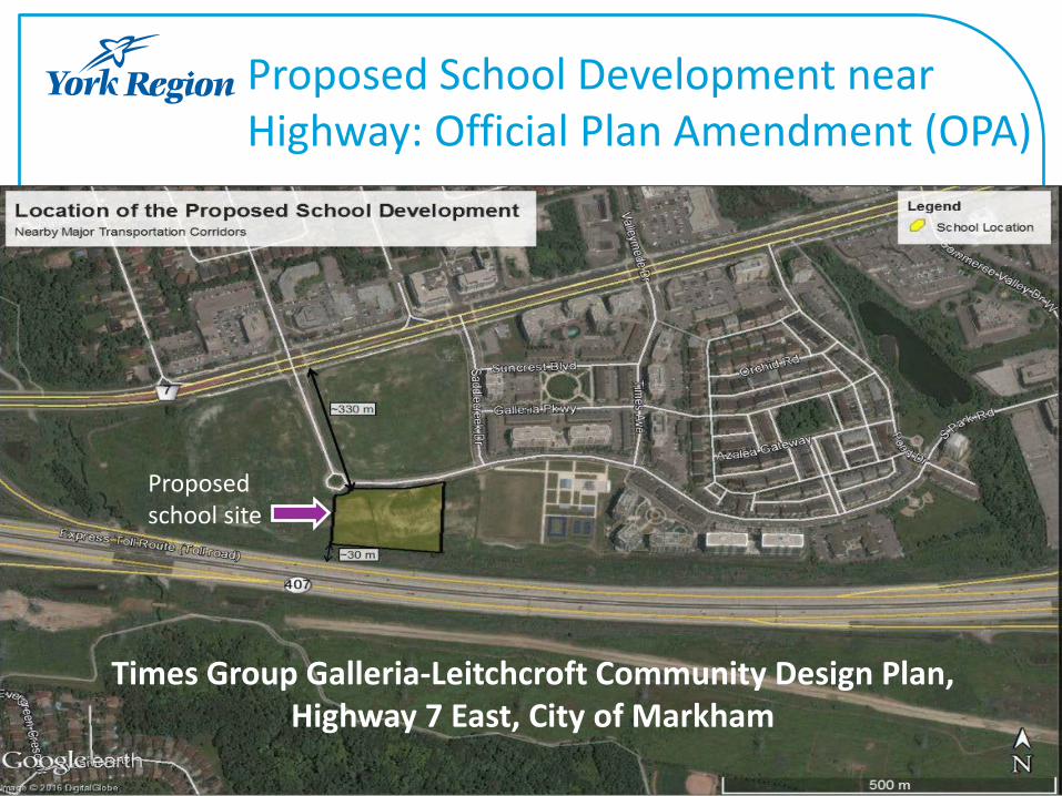
School Siting Case Study Issue: School Board assessed feasibility of a proposed school location given its proximity to Hwy 407 Steps: 1. OPA Notification from Regional Planning 2. Public health comments to municipality e.g. separating
sensitive uses (cited in ROP) and mitigation measures 3. Municipality shared public health comments with School Board 4. School board requested public health comment on air quality
study 5. Public health comments contributed to School Board decision to
look for an alternate site
8
9
Proposed School Development near Highway: Official Plan Amendment (OPA)
Times Group Galleria-Leitchcroft Community Design Plan, Highway 7 East, City of Markham
Proposed school site
10
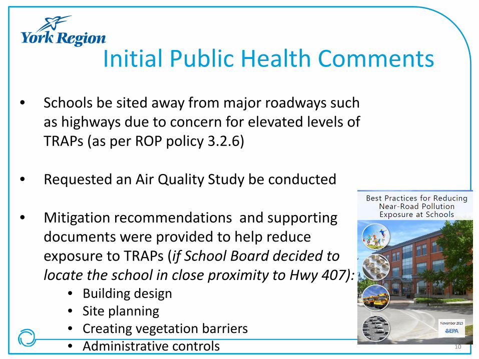
• Schools be sited away from major roadways such as highways due to concern for elevated levels of TRAPs (as per ROP policy 3.2.6)
• Requested an Air Quality Study be conducted
• Mitigation recommendations and supporting documents were provided to help reduce exposure to TRAPs (if School Board decided to locate the school in close proximity to Hwy 407):
• Building design • Site planning • Creating vegetation barriers • Administrative controls
Initial Public Health Comments
11
Air Quality Study
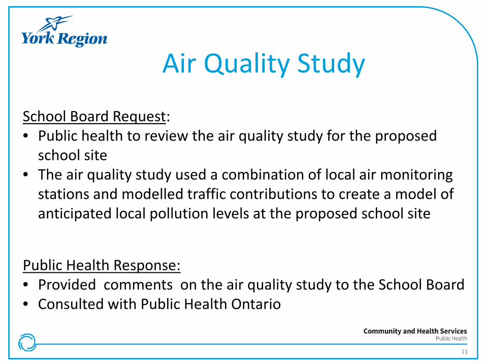
School Board Request: • Public health to review the air quality study for the proposed
school site • The air quality study used a combination of local air monitoring
stations and modelled traffic contributions to create a model of anticipated local pollution levels at the proposed school site
Public Health Response: • Provided comments on the air quality study to the School Board • Consulted with Public Health Ontario

12
Public Health & School Board Collaboration : Air Quality Study
PHO findings upon reviewing Air Quality Study Report: • TRAP is a well-documented risk factor for children’s health, and the site
of this school falls within an area defined as ‘near-highway exposure’ • Air sampling was not recommended given current TRAP evidence but
could be useful to inform building controls and design considerations • Measurements of PM2.5, PM10, NO2 and ultrafine particulate at the
site would be informative if air sampling was to be conducted • Report provided sampling strategies, elements and recommendations
that should be considered in developing a site specific assessment, and decision making criteria for school citing
13
School Board Decision on the Proposed School Development
Final Decision: • School board decided that school site was not optimal. Working with
the City of Markham to assess alternative locations Challenges: • Increased urbanization and growth impacts the school boards ability to
identify suitable locations for future school sites.
Lessons Learned: • Important, early in the planning process, to ensure that proposed
school location is suitable for students • Public health plays an important role by providing the required
evidence, best practice and policies to address TRAPs
14
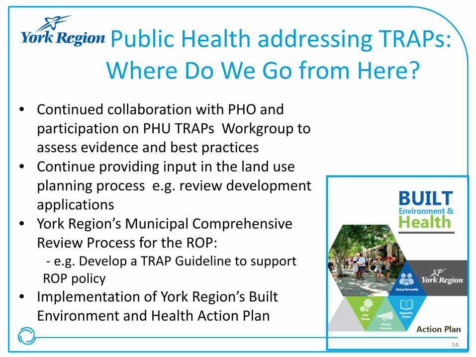
Public Health addressing TRAPs: Where Do We Go from Here?
• Continued collaboration with PHO and participation on PHU TRAPs Workgroup to assess evidence and best practices
• Continue providing input in the land use planning process e.g. review development applications
• York Region’s Municipal Comprehensive Review Process for the ROP: - e.g. Develop a TRAP Guideline to support ROP policy
• Implementation of York Region’s Built Environment and Health Action Plan

15
Thank You
Questions?