ProSus - start.orgstart.org/wp-content/uploads/ProSus-Magazine-November-2018.pdf · Liquefaction...
24
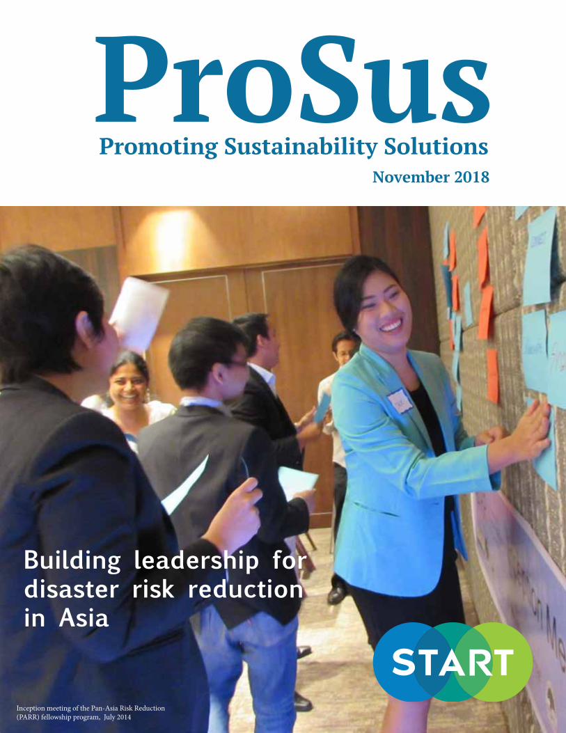
November 2018 ProSus Promoting Sustainability Solutions Building leadership for disaster risk reduction in Asia Inception meeting of the Pan-Asia Risk Reduction (PARR) fellowship program, July 2014
Transcript of ProSus - start.orgstart.org/wp-content/uploads/ProSus-Magazine-November-2018.pdf · Liquefaction...
November 2018
ProSusPromoting Sustainability Solutions
Building leadership fordisaster risk reduction in Asia
Inception meeting of the Pan-Asia Risk Reduction (PARR) fellowship program, July 2014

ProSus - November 2018 2
IN THIS ISSUE
Research
Snapshots
Establishing a Database Towards Developing a Typhoon Impact Estimation System (TIES) for the PhilippinesBy Maria Flordeliza P. Del Castillo, Manila Observatory, Philippines
Partners and supporters include:
Earthquake Damage Prediction in Different Earthquake Parameter and Liquefaction Effect for Banda Aceh City, IndonesiaBy Ibnu Rusydy, Tsunami and Disaster Mitigation Research Center (TDMRC) of Syiah Kuala University, Indonesia
An Attempt to Evaluate Economic and Non-Economic Losses & Damages due to Flooding among the Urban Poor Households in Metro ManilaBy Justin Charles G. See, Manila Observatory, Philippines
Urban-Water Nexus: Risk Based Assessment and Management of Water Quality Relating to Urban Flooding in the Pahang River Basin, MalaysiaBy Dr. Lubna Alam, LESTARI, National University of Malaysia
Disaster Risk Reduction and Climate Change Adaptation Integration into Development Planning: The Case of Peri-Urban Bandung, IndonesiaBy Nurrohman Wijaya, Department of Urban and Regional Planning, Bandung Institute of Technology (URP-ITB), Indonesia
Risk Communication Strategies: Case of Riverine Communities in Philippine CitiesBy Alvidon F. Asis, League of Cities of the Philippines
6
8
12
14
18
20
11, 17
The PARR network 4
Stories from the frontline
10, 16, 22
3 questions to Prof. Rajib Shaw 5
Between 2014 and 2018, the Pan-Asia Risk Reduction (PARR) fellowship program provided a unique opportunity for learning, training, and networking to early-career researchers and professionals working on urban disaster risk reduction.
ProSus is a biannual e-magazine published by START International.Find out more at www.start.org/prosus

ProSus - November 2018 3
Fellows, mentors and experts at the PARR culmination meeting that took place December 2017 in Manila.
We could tell the story of the Pan-Asia Risk Reduction (PARR) fellowship program through the numbers, but numbers alone do not do justice to the footprint of the program, which has greatly contributed to building a community and establishing momentum for collaboration on disaster risk reduction in the region.
Seeds of transformation can only mature when there is the right environment for innovation and participation. PARR provided a space for early-career scientists to cultivate their expertise and leadership skills, for institutions to explore solutions to regional priorities, and for local communities to engage and gain recognition through the dissemination of research outputs.
We are pleased to share, in this first edition of START’s magazine, the findings of action-oriented research
conducted by the program’s 2016-2018 fellows. Their outstanding work, with support of their institutions and all PARR partners, is contributing to the advancement of regional knowledge to meet pressing urban disaster risk reduction challenges.
The PARR program has developed a network and a platform for learning exchanges and leadership development in Asia. START looks forward to continued engagement with fellows and partners and supporting and strengthening this network. The successes and lessons learned from PARR are a valuable resource for START and partners, as we look at replicating and scaling-up the model to benefit other regions as well.
Congratulations to all fellows; warmest compliments to the mentors and support institutions for the excellent work done.
WelcomeBy Dr. Cheikh MbowExecutive Director, START International
PARR provided a space for early-career scientists to cultivate their expertise and leadership skills, for institutions to explore solutions to regional priorities, and for local communities to engage.-Cheikh Mbow

ProSus - November 2018 4
Kyoto University, Japan
National Science and Technology Center for Disaster Reduction, Taiwan
Manila Observatory, Philippines
University of the Philippines
Fellows traveling to Kyoto U.
Fellows traveling to NCDR
Fellows traveling to Manila Observatory
Fellows traveling to UPLB
Los Baños
A total of twenty-two fellows from seven countries participated in the Pan-Asia Risk Reduction (PARR) fellowship program, a yearlong fellowship experience which included an immersive one- to three-month stay at a host institution in Asia. A competitive process granted additional funding to select fellows to carry out independent research projects. Fellows produced manuscripts for submission to peer-reviewed journals, policy briefs for local government, or communications materials targeted to local stakeholders and communities.
START led two fellowship rounds between 2014 and 2018, with the support of the United States National Science Foundation, the Oscar M. Lopez Center, USAID, the Asia Pacific Network for Global Change Research, the IRDR International Center of Excellence (ICoE) Taipei, and strategic direction from the PARR Alliance, a consortium of science-focused research, education, and capacity building institutions in Asia.
Learn more at: start.org/programs/PARR
The PARR Network

ProSus - November 2018 5
Why are programs like PARR important for the region?PARR provides a cross learning experience to young professionals and practitioners. It is a unique process, which nurtures these young talents by engaging them in action research and exposing them to state-of-the-art disaster risk reduction facilities in the host institutes.
What has PARR’s biggest achievement been in your view?PARR has created a network of motivated researchers and practitioners, who have jointly pursued innovative research and published peer reviewed journal articles. Seed funding has also allowed them to conduct cutting edge action research.
What would be your advice to young researchers and practitioners starting their career in disaster risk reduction in Asia?Young researchers are the key to a successful implementation of the Sendai Framework for Disaster Risk Reduction and Sustainable Development Goals. Thus, my message to them is to keep motivated, continue co-designing risk reduction solutions along with other stakeholders, and finding appropriate options for their implementation.
Rajib Shaw is a Professor at the Graduate School of Media and Governance, Keio University. Previously, he served as Executive Director of IRDR (Integrated Research on Disaster Risk). He is Chair of the United Nations Science Technology Advisory Group (STAG) for disaster risk reduction and Co-Chair of the Asia Science Technology Academic Advisory Group (ASTAAG). Prof Shaw is the editor of a Springer book series on disaster risk reduction and has published more than 45 books and over 300 academic papers and book chapters.
3 questions to Prof. Rajib Shaw
READING LISTA quick look at three knowledge briefs developed during PARR’s pilot phase
Design and Framework for a Deci-sion Support System for Highly Urbanized MegaCities: Case Study Metro Manila
NURTURING TALENT TO ADVANCE RISK REDUCTION
Exploring the Existing School-Community Network and Ena-bling Environment for Enhancing Community Resilience to Disaster
Flood Risk Vulnerability of Peri-urban Communities: The Case of Surat

ProSus - November 2018 6
Earthquake Damage Prediction in Different Earthquake Parameter and Liquefaction Effect for Banda Aceh City, Indonesia
The city of Banda Aceh is particularly vulnerable to earthquakes due to its geography and location. A study of possible earthquake scenarios, and their effects on people and buildings, can provide precious insights to city officials and support disaster mitigation and preparedness plans.
Ibnu Rusydy, Tsunami and Disaster Mitigation Research Center (TDMRC) of Syiah Kuala University, Indonesia
New housing in Ule Lheu, Banda Aceh, Indonesia, part of a World Bank reconstruction effort following the 2004 Asian tsunami. Photo: Abbie Trayler-Smith / Panos Pictures / Department for International Development (DFID)

ProSus - November 2018 7
Earthquake Damage Prediction in Different Earthquake Parameter and Liquefaction Effect for Banda Aceh City, Indonesia
The journey continues...
Ibnu Rusydy is furthering knowledge in earthquake vulnerability in Indonesia. He presented his findings at the 7th International Symposium on Earth-Hazard and Disaster Mitigation in West Java, Indonesia in November 2017 and published a paper focusing on Banda Aceh’s Kuta Alam subdistrict (AIP Conference Proceedings, July 2018). He has also published two papers on the research he undertook during his fellowship exchange with the University of the Philippines, estimating building vulnerability and human loss at the University’s Los Baños campus in different earthquake scenarios (Philippines Journal of Science, June 2018 and IOP Conference Series, 2017).
Ibnu Rusydy works at Syiah Kuala University, Indonesia as a researcher at the Tsunami and Disaster Mitigation Research Center and as a lecturer at the Geological Engineering Department. He holds a Bachelor’s degree in Geophysics from Syiah Kuala University and a Master’s degree (MSc) in Engineering Geology from the National University of Malaysia (Universiti Kebangsaan Malaysia – UKM). In the past five years he has published more than 20 scientific papers and created a website to disseminate disaster knowledge.
Objectives
The study aimed at predicting the effects of an earthquake in the city of Banda Aceh, estimating casualties, injuries and damage ratio as well as distribution according to earthquake intensity and time of the day.
Approach
Tectonic and geological datasets were collected and processed with GIS software to generate intensity maps for different earthquake scenarios. Geo-electrical data was acquired and analyzed to determine groundwater levels, which affect soil liquefaction. An inventory of over 62,000 buildings was carried out, dividing the buildings in four categories with different fragility rates. The datasets were combined and analyzed to estimate the percentage of damages and injuries based on predicted building occupancy.
Results OverviewThe study developed four models - three earthquakes generated from the Aceh segment of the Great Sumatran Fault (Mw 7, Mw 6.5, and
Mw 6) and one from the Seulimuem segment (Mw 6.5). The analysis produced a map of building damages for each scenario. The study showed that the strongest earthquake from the Aceh segment would damage 47-75% of the town’s buildings and injure 5 to 26% of the population in almost all of the town’s sub districts during day time, and 22% of the population during night time (over 57,700 people).
ConclusionThe study produced maps showing the vulnerability of Banda Aceh subdistricts to earthquakes, and an estimate of damages and injuries that different intensity earthquakes would cause. The findings were presented to local government and non-governmental organizations’ representatives during a seminar in September 2017. City officials confirmed that the study provides key knowledge that can support preparedness plans, including targeted building restoration and the development of earthquake simulation programs.

ProSus - November 2018 8
An Attempt to Evaluate Economic and Non-Economic Losses & Damages due to Flooding among the Urban Poor Households in Metro Manila
Tropical cyclones frequently hit the Philippines with heavy impacts on infrastructure, agriculture and communities. A mechanism to assess damages and losses is crucial in informing decision-making and policy development. However, existing assessments only focus on infrastructure damages, neglecting the significance of other types of impacts on people, such as those related to physical and mental health, education and social capital. This research is an attempt to evaluate both economic and non-economic losses due to floods at the household level.
Justin Charles G. See, Manila Observatory, Philippines
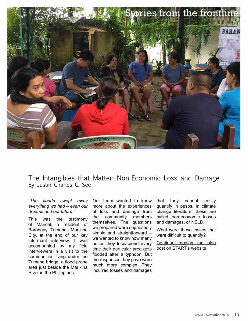
An interviewer asks a community member in Marikina City, Metro Manila, about her experience living in the flood-prone area.

ProSus - November 2018 9
An Attempt to Evaluate Economic and Non-Economic Losses & Damages due to Flooding among the Urban Poor Households in Metro Manila
The journey continues...
Justin See, together with his mentor Prof. Emma Porio, have co-authored a journal article that features the results of his PARR fellowship and that is currently being peer-reviewed. He is also working on a paper with PARR fellow Liz Del Castillo. They are attempting to combine both of their research, i.e. to estimate economic and non-economic flood loss and damage utilizing satellite-based information (through GIS) and socio-economic factors.Justin is currently pursuing a Ph.D. in La Trobe University in Australia, looking at climate change adaptation and its prospects for distributive justice.
Justin Charles G. See is a Ph.D. candidate at the Department of Social Inquiry in La Trobe University, Melbourne, Australia. He is currently doing research on distributive justice in climate change adaptation projects and strategies in Iloilo City, Philippines. From 2012 to 2016, he was a member of the Coastal Cities at Risk Project of the International Research Initiative on Adaptation to Climate Change (IRIACC), investigating climate change vulnerability, adaptation, and resilience in Metro Manila. He also served as research associate at the Manila Observatory, and taught introductory sociology and social statistics at Ateneo de Manila University.
Objectives The main objective of this research is to understand and deconstruct both the economic and non-economic losses that urban poor households in Metro Manila incur from climate-related disasters. This study attempts to consider several dimensions, including social, economic, psychological, political, and environmental, in order to obtain an integrated and holistic damage estimation.
Approach A conceptual framework to measure loss and damage was built and used as a theoretical lens in the development of methodologies for assessing losses and damages. A survey of 300 respondents residing in flood-prone areas in the upstream, midstream, and downstream areas of Metro Manila shed light on economic losses. Three focus group discussions were conducted to collect data on non-economic losses and damages.
Results OverviewThree components of risk - hazard, exposure, and vulnerability - were significant determinants of flood loss and damage. Gender, income and age were also significant predictors: considerable losses were incurred by households with more female members and lower income. The average income of the survey’s respondents is barely enough to pay for everyday expenses. Following major flooding events, many respondents said that they need to contract loans to recover from losses.
The focus group discussion revealed the non-economic impacts. Even though none of the participants in the focus group lost a family member due to flooding, several of them experienced guilt, remorse, or trauma. The floods also had significant impact on the community’s social networks, children’s education, and local governance. The study highlights the complex nature of the interactions between economic and non-economic loss and damage, i.e. how they are not mutually exclusive but are related to one another. This research therefore contributes to the body of knowledge on loss and damage assessment, as it expands the current binary conceptualizations of loss and damage as separate and distinct when actually the relationships are quite fluid and dynamic.
ConclusionThis research can help support policy development in the field of disaster risk reduction and climate change adaptation. Based on the findings, three recommendations are provided: 1. providing platforms and opportunities for alternative sources of income and livelihood - the majority of respondents were forced to borrow money, which can lead to further marginalization and dependency;2. encouraging residents’ involvement in their community in order to build social capital and social networks;3. addressing the communities’ mental and emotional well-being right after a disaster, to help affected populations cope with traumatic experiences.
ProSus - November 2018 10
“The floods swept away everything we had – even our dreams and our future.”
This was the testimony of Maricel, a resident of Barangay Tumana, Marikina City, at the end of our key informant interview. I was accompanied by my field interviewers in a visit to the communities living under the Tumana bridge, a flood-prone area just beside the Marikina River in the Philippines.
Our team wanted to know more about the experiences of loss and damage from the community members themselves. The questions we prepared were supposedly simple and straightforward – we wanted to know how many pesos they lose/spend every time their particular area gets flooded after a typhoon. But the responses they gave were much more complex. They incurred losses and damages
that they cannot easily quantify in pesos. In climate change literature, these are called non-economic losses and damages, or NELD.
What were these losses that were difficult to quantify?
Continue reading the blog post on START’s website
The Intangibles that Matter: Non-Economic Loss and DamageBy Justin Charles G. See
Stories from the frontline
ProSus - November 2018 11
SNAPSHOTS
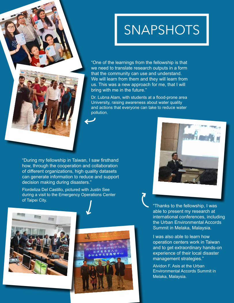
“One of the learnings from the fellowship is that we need to translate research outputs in a form that the community can use and understand. We will learn from them and they will learn from us. This was a new approach for me, that I will bring with me in the future.”Dr. Lubna Alam, with students at a flood-prone area University, raising awareness about water quality and actions that everyone can take to reduce water pollution.
“During my fellowship in Taiwan, I saw firsthand how, through the cooperation and collaboration of different organizations, high quality datasets can generate information to reduce and support decision making during disasters.” Flordeliza Del Castillo, pictured with Justin See during a visit to the Emergency Operations Center of Taipei City.
“Thanks to the fellowship, I was able to present my research at international conferences, including the Urban Environmental Accords Summit in Melaka, Malaysia.
I was also able to learn how operation centers work in Taiwan and to get extraordinary hands-on experience of their local disaster management strategies.”Alvidon F. Asis at the Urban Environmental Accords Summit in Melaka, Malaysia.

ProSus - November 2018 12
Establishing a Database Towards Developing a Typhoon Impact Estimation System (TIES) for the Philippines
An average of nine typhoons hit the Philippines every year, affecting millions of people. Their impacts have been historically recorded, but datasets are not easily accessible as they are compiled and stored by a number of government agencies. Gathering, integrating and analyzing this data would allow researchers to generate insights to support decision-making during extreme weather events as well as long-term disaster risk reduction planning.
Maria Flordeliza P. Del Castillo, Manila Observatory, Philippines
Fisherman’s cottages in The Philippines. Stilts increase the houses resilience to flooding. Photo: iStock

ProSus - November 2018 13
Objectives
The research aimed at integrating available datasets to develop a tool that estimates typhoon impacts in the Philippines. The tool would be used to easily explore and understand data, allowing decision-makers and responders to rapidly estimate possible typhoon-related damages, and to communicate possible risks to communities.
Approach Relevant datasets were collected, encoded, integrated in worksheets and mapped using ArcGIS. Data collected include typhoon reports, flood hazard, landslide hazard, storm surge hazard, administrative boundaries, elevation, population, demographics and agriculture.Mentors from the National Science and Technology Center for Disaster Reduction (NCDR) provided precious input, sharing their experience developing Taiwan’s Typhoon Loss Assessment System and Decision Support System.
Results OverviewThis research produced an inventory of datasets regarding typhoon impacts, a preliminary data-
base, a simple numerical analysis tool for estimating scenario-based typhoon impact on population and agriculture, and maps facilitating visualization, communication and understanding of various typhoon hazard scenarios. A proposed scheme for data integration among various agencies and institutions in the Philippines was also developed.
ConclusionThe 5-months project produced an initial sample of a Philippines’ Typhoon Impact Estimation System (TIES), a simple tool for estimating typhoon impacts in the Philippines. More work is needed to develop a fully operational tool - improvements include populating the database with more and better resolution datasets, and allowing multi-hazard scenarios and multi-criteria loss and damage analysis that would integrate hazard data for typhoons, flooding, landslides and surges (at the moment scenarios can be only generated for one single hazard). When fully operational, this tool can be used by stakeholders in planning and risk management, as well as in risk education and communication.
Establishing a Database Towards Developing a Typhoon Impact Estimation System (TIES) for the Philippines
The journey continues...Maria Flordeliza P. Del Castillo is applying to PhD scholarship programs to further research in this field. With fellow Justin See, she is working on a paper combining their research, focusing on both economic and non-economic impacts of weather hazards in selected sites in Metro Manila.
The database developed during the fellowship is proving to be a useful resource for the Manila Observatory, and it is being used as an input for mapping and reporting on community exposure and vulnerability to extreme weather events.
Maria Flordeliza P. Del Castillo has been working at the Manila Observatory for more than seven years as a Research Assistant and RS-GIS Specialist. She has worked on several projects that focused on integrated disaster risk, hazard, exposure, vulnerability and adaptation mapping and decision support systems for city resilience. She holds a Master’s Degree in Environmental Science in Ateneo de Manila University and a Certificate on International Environmental Leadership for “Women Leaders Promoting ESD based on Local Community” from Kobe College.

ProSus - November 2018 14
Risk Communication Strategies: Case of Riverine Communities in Philippine Cities
Almost all of the cities of the Philippines are situated in proximity of rivers, with settlements along the waterways that are highly vulnerable to floods. Effective risk communication - the real time exchange of information between experts, officials and people facing a threat to their wellbeing - can help communities be better prepared and respond timely when disasters occur. The National Disaster Risk Reduction and Management Framework includes provisions for risk communication - but how are these provisions implemented at the local level?
Alvidon F. Asis, League of Cities of the Philippines
A communications officer at the Central Communications Center of Naga City. This office manages communications related to flooding during typhoons.

ProSus - November 2018 15
Objectives
The study aimed at identifying and analyzing risk communication strategies of riverine communities in six cities in the Philippines. In particular, the research aimed at identifying how local governments are mainstreaming the risk communication provisions of the National Disaster Risk Reduction and Management (DRRM) Framework and at providing policy recommendations to address any gaps.
Approach Six cities within major river basins were identified, from the three island clusters - Luzon, Visayas and Mindanao. Focus group discussions, interviews and site visits were conducted to identify the local risk communication strategies and document initiatives of the local government.
Results OverviewAll of the cities analyzed address risk communication in their disaster plans. All risk communications strategies, even though at different stages of approval and implementation, are aligned with the standards set by the DRRM Framework.Examples of risk communication from the six cities include agreements with local radio and television stations to provide preparedness messages and timely announcements in case of flooding; mobile applications that allow users to report and access real time information about
the floods; and investments in dedicated teams to monitor and share content on social media platforms. Several factors affect the quality of risk communications strategies, including awareness among local leaders, access to funding, and community engagement.
ConclusionRisk communication strategies compliant with national standards have been drafted in all the selected cities. Because of the lack of centralized coordination and support, the strategies are often prepared with the help of external organizations, leading to inconsistent quality. Districts with better knowledge of disaster risk reduction, more resources, and more support from the communities tend to have better strategies. The findings of this research were presented to the National Disaster Risk Reduction and Management Council - Technical Management Group. It was also presented during the Urban Environmental Accords, Melaka Summit in Malaysia in 2017 and during the National Executive Board meeting of the League of Cities of the Philippines, where mayors had the opportunity to learn about strategies and approaches in place in the six cities analyzed during the study. The findings were also used by the League of Cities of the Philippines to draft resolutions supporting the prioritization of risk communication to riverine communities.When fully operational, this tool can be used by stakeholders in planning and risk management, as well as in risk education and communication.
Risk Communication Strategies: Case of Riverine Communities in Philippine Cities
The journey continues...
Alvidon Asis has remained in contact with other fellows, and has invited some of them to present their research at the 3rd International River Summit in 2016. In July 2017, the League of Cities of the Philippines organized the ASEAN Mayors Forum and PARR sponsored two fellows to speak on disaster resilience. The fellowship provided precious oppportunities to connect with experts at the regional scale. For example, Alvidon presented his research at the Urban Environmental Accords (UEA Summit) in Melaka, Malaysia in September 2017. He is planning to expand the research activity to include other cities and to present the results during the next International River Summit.
Alvidon F. Asis heads the Environment Programs of the League of Cities of the Philippines, the country’s mandated organization of 145 cities. He is a member of the National Disaster Risk Reduction and Management Council’s Technical Management Group and of technical working groups on issues related to cities. He holds a Master’s degree in Environmental Science.

ProSus - November 2018 16
Ready for Action: A behind-the-scenes look at disaster preparedness in the PhilippinesBy Alvidon F. Asis
Stories from the frontline
Left: Mandaue City experiences flooding once or twice a year. The central command center monitors all the city’s critical areas, including those prone to flooding. During flood events, Bantay Mandaue, the city’s communication center, sends key information to Barangay officials, as well as local radio and television stations.Massive training programs about flood risks and prevention are regularly organized and reach all the population.
Top right: The Emergency Response Team maintains equipment in the disaster office of Naga City.The city has also put in place a team focusing exclusively on social media, broadcasting information during disasters, monitoring and validating the information shared online. Social media are widely popular and well accepted in Naga City and are the fastest way to communicate during disasters.
Bottom right: City officials and barangay captains exchange ideas on improving river management in Cotabato City. Two major rivers flow through the city, and early warning devices alert the community in case of flooding.The local government has inititated dredging efforts to mitigate the effects of flooding, and has requested additional funding and equipment from the Department of Public Works.

ProSus - November 2018 17
“My mentor at the Manila Observatory brought me to meet vulnerable communities and key stakeholders. This was an eye-opening experience: as researchers, we often are so busy doing desk work that we forget to understand the real issues in the communities. Since the fellowship, I have tried to continue using both a top-down and bottom-up approach in my research on climate-related disasters and risk reduction management.”Nurrohman Wijaya during an immersion program with an urban poor community in Quezon City, Philippines.
SNAPSHOTS
“My best memory from the fellowship is the friendship I tied with colleagues from the University of the Philippines Los Baños (UPLB), and the collaboration to collect data about UPLB buildings.”Ibnu Rusydy took these pictures during a progress meeting with the supervisor at UPLB and during geological field work.
“The fellowship gave me an unique opportunity to conduct independent and quality research with the mentorship and guidance of experts and practitioners from all over the world. It exposed me to the actual conditions in the field, and it enabled me to talk to people and listen to their stories. I feel very lucky to be able to do research, travel, get to know about other cultures, and expand my professional networks through the PARR fellowship.”Justin C. See with field work interviewers in a flood-prone area near Marikina river, Metro Manila.
ProSus - November 2018 18
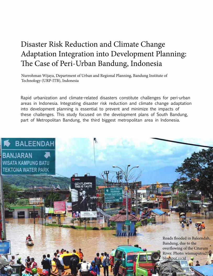
Disaster Risk Reduction and Climate Change Adaptation Integration into Development Planning: The Case of Peri-Urban Bandung, Indonesia
Rapid urbanization and climate-related disasters constitute challenges for peri-urban areas in Indonesia. Integrating disaster risk reduction and climate change adaptation into development planning is essential to prevent and minimize the impacts of these challenges. This study focused on the development plans of South Bandung, part of Metropolitan Bandung, the third biggest metropolitan area in Indonesia.
Nurrohman Wijaya, Department of Urban and Regional Planning, Bandung Institute of Technology (URP-ITB), Indonesia
Roads flooded in Baleendah, Bandung, due to the overflowing of the Citarum River. Photo: wismaputra27.blogspot.co.id

ProSus - November 2018 19
Objectives
This study attempted to assess to what extent the local government of peri-urban Bandung has included disaster risk reduction and climate change adaptation in its development planning.
Approach Several approaches and methods were employed: content analysis of development and spatial plans, interviews with key informants (including local government officers, researchers, non-governmental organization officials and community leaders), field and institutional surveys. The study directly supported the research roadmap of the Bandung Institute of Technology on disaster mitigation and public policy development.
Results OverviewThe findings suggest that local development plans in the South Bandung Area do not include strong climate change adaptation and disaster risk reduction components. Plans take into account environmental aspects of climate adaptation but
disregard other important dimensions, such as those related to infrastructural, social, economic and health issues. When the local government has adopted measures to reduce vulnerability in disaster-prone areas, including improving drainage systems, or building a water storage pond, they have not done so deliberately as part of a disaster risk reduction program.
ConclusionA lack of deep understanding of climate adaptation and disaster risk reduction, together with the specific characteristics of peri-urban areas, could be the cause of South Bandung’s failure to include them in its development plans. It is important to increase awareness of these challenges, so that local governments can take the most appropriate measures to decrease the vulnerability of the local communities. The preliminary findings of this study were presented during the Indonesia University of Education (UPI) International Geography Seminar in August 2017 in Bandung. It is hoped that the local government of South Bandung, as well as other cities, will use these lessons learned and inputs to develop policies and plans.
Disaster Risk Reduction and Climate Change Adaptation Integration into Development Planning: The Case of Peri-Urban Bandung, Indonesia
The journey continues...The output of this research has been published in the conference proceeding with reference: Wijaya, N. 2018. Disaster Risk Reduction and Climate Change Adaptation Integration into Peri-Urban Development Planning: A Case Study of Bandung Metropolitan Area, Indonesia. IOP Conf. Ser.: Earth Environ. Sci. 145 012079. DOI: 10.1088/1755-1315/145/1/012079. In addition, the overall results are being drafted in the form of a manuscript to submit to an international academic journal.
Nurrohman Wijaya is a researcher at the Department of Urban and Regional Planning, Bandung Institute of Technology (URP-ITB), Indonesia. He is currently studying at the Department of Urban Environmental Management, Asian Institute of Technology (UEM-AIT), Thailand pursuing a PhD in “Urban development and climate adaptation in coastal cities of Indonesia”. He received Master’s degrees from URP-ITB in 2006 and UEM-AIT in 2010, and a Bachelor’s degree from URP-ITB in 2004.
ProSus - November 2018 20
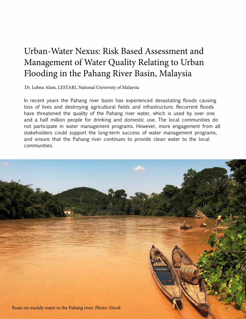
Urban-Water Nexus: Risk Based Assessment and Management of Water Quality Relating to Urban Flooding in the Pahang River Basin, Malaysia
In recent years the Pahang river basin has experienced devastating floods causing loss of lives and destroying agricultural fields and infrastructure. Recurrent floods have threatened the quality of the Pahang river water, which is used by over one and a half million people for drinking and domestic use. The local communities do not participate in water management programs. However, more engagement from all stakeholders could support the long-term success of water management programs, and ensure that the Pahang river continues to provide clean water to the local communities.
Dr. Lubna Alam, LESTARI, National University of Malaysia
Boats on muddy water in the Pahang river. Photo: iStock

ProSus - November 2018 21
Objectives
The goal of the study was to assess the risk of urban water contamination in the Pahang river basin, to identify existing and potential water management practices, and to recommend strategies to decrease the risk of contamination.
Approach Water quality data from 2006 to 2016 was kindly provided by the Department of Environment and the Malaysian Meteorological Department, and data for 2017 was obtained as part of the study. Surveys with communities living in flood-prone areas explored water management practices. Interviews with non-governmental organizations and local stakeholders focused on potential strategies for risk reduction.
Results OverviewWater quality parameters were within the range of recommended values for Malaysian raw water. The study did not identify any carcinogenic or non-carcinogenic risks linked to the components found in the water. However, the research also highlighted a significant correlation between the climatic variables and the water quality.
The surveys found that the local population is aware of the importance of water quality and willing to participate in water management programs.
Interviews with stakeholders from the government, non-governmental organizations, the private sector and the university highlighted several recommended risk reduction measures and strategies, including improving irrigation and drainage systems, increasing community engagement and organizing river cleanup programs.
ConclusionThe findings suggest that the Pahang river water is safe for drinking and domestic use. However, there is a risk that the water quality will decrease with future changes in climate. The local communities, although interested in water quality issues, have not been engaged in water management programs up to now - an increased involvement of the communities, including through education and awareness raising programs, is recommended. As a first step in this direction, a pamphlet and a quiz competition have been developed to raise awareness about water quality and actions that everyone can take to reduce water pollution.
Urban-Water Nexus: Risk Based Assessment and Management of Water Quality Relating to Urban Flooding in the Pahang River Basin, Malaysia
The journey continues...A similar study has been conducted in the Langat river basin, Malaysia, considered a highly polluted area due to rapid urbanization. The objective of this study was to determine the status of contaminants in the water of the Langat river basin, to estimate potential health risks associated with drinking water contamination and to recommend the best drinking water management practice. Lubna Alam has also been awarded a Fellowship by TWAS (The World Academy of Sciences), a world renowned organization based in Italy to conduct research on exploring links between water and health in South and South East Asia. Lubna keeps in contact with other PARR fellows and her mentor, including through social media.
Dr. Lubna Alam is a Research Fellow at the Institute for Environment and Development (LESTARI) of the National University of Malaysia. She received her Ph.D. in Ocean Science from the National University of Malaysia, her Master’s degree (MSc) in Marine Science from the same university and Bachelor’s degree (BSc) in Fisheries from the University of Rajshahi, Bangladesh. Dr. Lubna has more than 10 years of experience in Environmental Science and is the author and co-author of over 60 peer-reviewed scientific publications, conference papers and book chapters.

ProSus - November 2018 22
Unpacked: A field researcher’s essentialsBy Lubna Alam
Stories from the frontline
The camera is essential to capture the field trip activityies for reporting and preserving memories of the trip.
A power bank is useful to charge our mobile phone if we experience problems with elec-tricity in remote areas.
Sometimes we need to print survey materi-als and questionnaires during the field trip and in remote areas printing facilities might not be available - a portable printer is thus very helpful.
In remote areas some-times pure water is not available, so I bring with me a water bottle.
On my laptop I can prepare or edit questionnaires, leaflets, or other research materials on the go.
In case of power outages, I have with me a torch light.
Tissues, wipes, hand sanitizer, and mosquito repellent: the basics for a field trip.
A notebook and a pen are the most important tools during field work. I use them to write down the description of the study area, any opinions of respondents and any special remarks.
Once during field work I could not charge my phone because my charger and the plug did not match. I could not reach my family for 2 days! Since then, I always bring with me a universal adapter.
- a water quality multi-parameter to measure the quality of the water in the study area;- an umbrella to protect us from rain or sunshine;- a mini projector to use with fellow researchers or to show findings to the local population...
I am not used to try differ-ent kinds of food and thus I always bring dry food with me during surveys.
And also...

ProSus - November 2018 23
Pasig City, Metro Manila, Philippines, at the height of tropical storm Maring in August 2013. The local government unit gets ready to repond, by preparing firetrucks and relief goods.Photo: Justin Charles G. See

ProSus - November 2018 24
www.start.org
ProSus is a biannual e-magazine published by START International.
Find out more at: www.start.org/prosus
START provides opportunities for training, research, education and networking that strengthen scientific skills and inspire leadership for advancing solutions to
critical sustainability challenges.
startinternational start_intl start-international-inc