![DSAT · 2015. 7. 22. · cheng han weng long so, u sam sol, chi mencj sonci chin cheng sono tan i sot', sou, sot], sou, sou, sot], sou, sot], sou, sou, sou, sou, in 10 hong kam choi](https://static.fdocuments.in/doc/165x107/60c2f5f91082346bf41443bb/2015-7-22-cheng-han-weng-long-so-u-sam-sol-chi-mencj-sonci-chin-cheng-sono.jpg)
Proposal SOU.C SOU
4
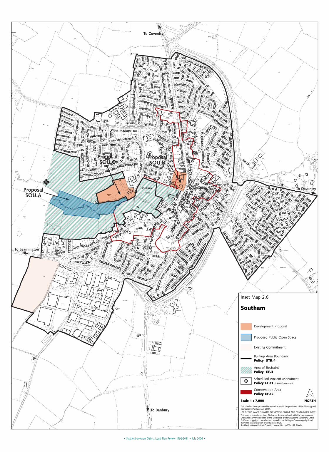
To Daventry To Banbury ❖ Proposal SOU.B Proposal SOU.C Proposal SOU.A To Coventry To Leamington • Stratford-on-Avon District Local Plan Review 1996-2011 • July 2006 • Inset Map 2.6 Southam Scale 1 : 7,000 NORTH This plan has been produced in accordance with the provisions of the Planning and Compulsory Purchase Act 2004. USE OF THIS IMAGE IS LIMITED TO VIEWING ON-LINE AND PRINTING ONE COPY. This map is reproduced from Ordnance Survey material with the permission of Ordnance Survey on behalf of the Controller of Her Majesty’s Stationery Office © Crown copyright. Unauthorised reproduction infringes Crown copyright and may lead to prosecution or civil proceedings. Stratford-on-Avon District Council, Licence No. 100024287 2000’s Development Proposal Proposed Public Open Space Existing Commitment Built-up Area Boundary Policy STR.4 Area of Restraint Policy EF.3 ❖ Scheduled Ancient Monument Policy EF.11 © HM Government Conservation Area Policy EF.12
Transcript of Proposal SOU.C SOU
To Daventry
To Banbury
❖
ProposalSOU.B
ProposalSOU.C
ProposalSOU.A
To Coventry
To Leamington
• Stratford-on-Avon District Local Plan Review 1996-2011 • July 2006 •
Inset Map 2.6
Southam
Scale 1 : 7,000 NORTH
This plan has been produced in accordance with the provisions of the Planning andCompulsory Purchase Act 2004.USE OF THIS IMAGE IS LIMITED TO VIEWING ON-LINE AND PRINTING ONE COPY.
This map is reproduced from Ordnance Survey material with the permission ofOrdnance Survey on behalf of the Controller of Her Majesty’s Stationery Office© Crown copyright. Unauthorised reproduction infringes Crown copyright andmay lead to prosecution or civil proceedings. Stratford-on-Avon District Council, Licence No. 100024287 2000’s
Development Proposal
Proposed Public Open Space
Existing Commitment
Built-up Area BoundaryPolicy STR.4
Area of RestraintPolicy EF.3
❖Scheduled Ancient MonumentPolicy EF.11 © HM Government
Conservation AreaPolicy EF.12
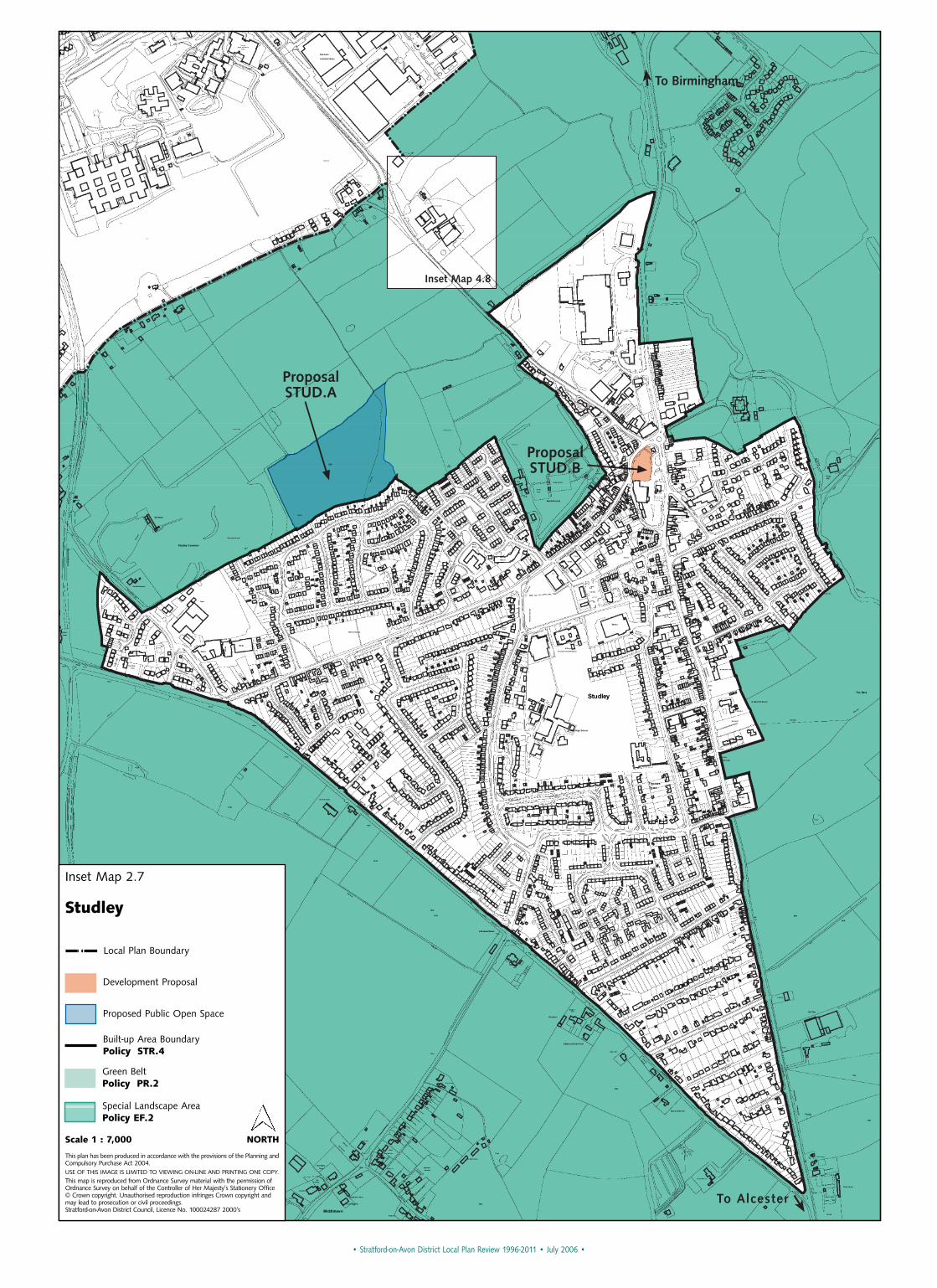
ProposalSTUD.A
ProposalSTUD.B
To Birmingham
To Alcester
Inset Map 4.8
• Stratford-on-Avon District Local Plan Review 1996-2011 • July 2006 •
Inset Map 2.7
Studley
Scale 1 : 7,000 NORTH
This plan has been produced in accordance with the provisions of the Planning andCompulsory Purchase Act 2004.USE OF THIS IMAGE IS LIMITED TO VIEWING ON-LINE AND PRINTING ONE COPY.
This map is reproduced from Ordnance Survey material with the permission ofOrdnance Survey on behalf of the Controller of Her Majesty’s Stationery Office© Crown copyright. Unauthorised reproduction infringes Crown copyright andmay lead to prosecution or civil proceedings. Stratford-on-Avon District Council, Licence No. 100024287 2000’s
Development Proposal
Proposed Public Open Space
Built-up Area BoundaryPolicy STR.4
Green BeltPolicy PR.2
Special Landscape AreaPolicy EF.2
Local Plan Boundary
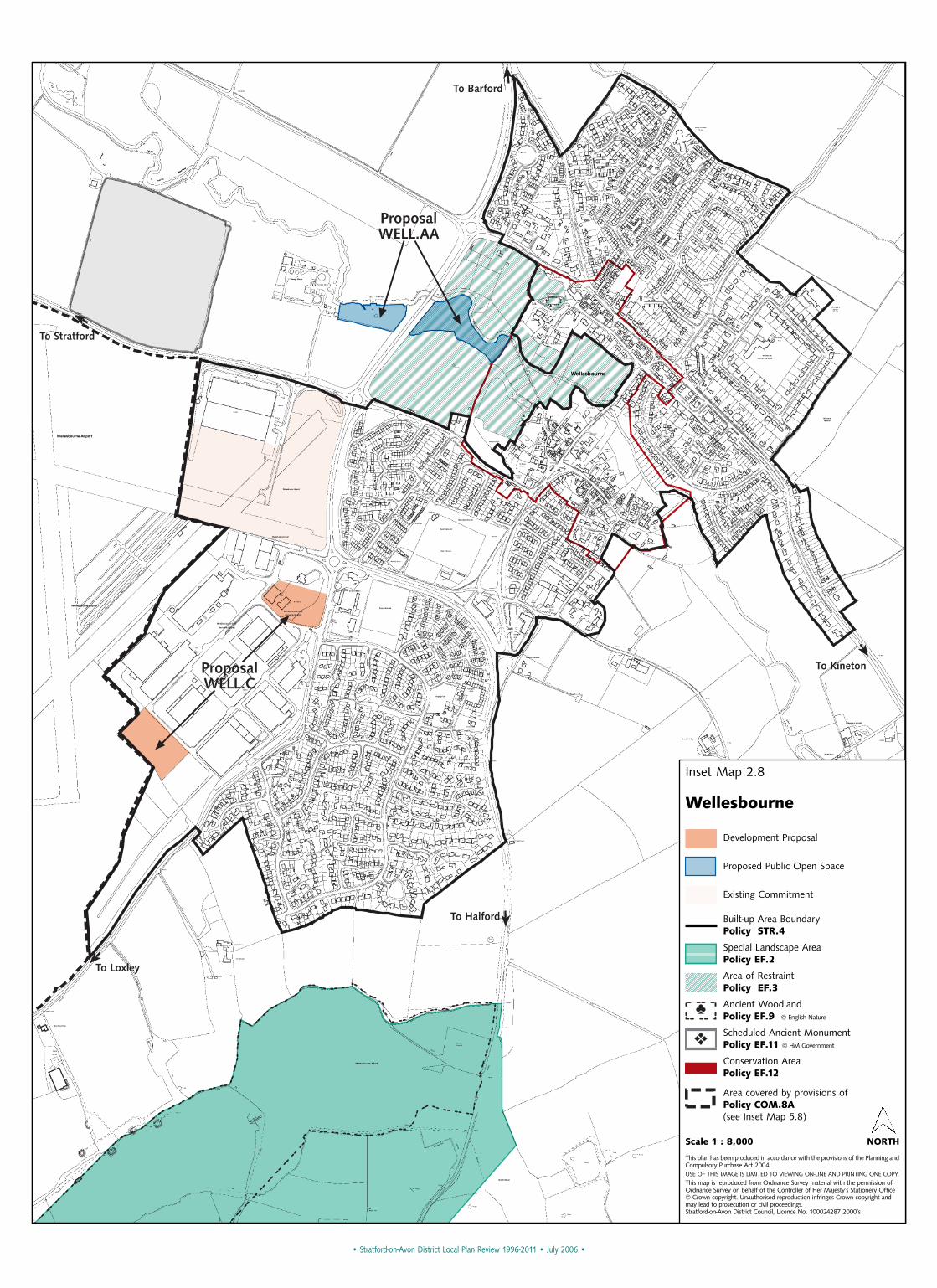
ProposalWELL.AA
ProposalWELL.C
To Stratford
To Barford
To Halford
To Loxley
To Kineton
• Stratford-on-Avon District Local Plan Review 1996-2011 • July 2006 •
Inset Map 2.8
Wellesbourne
Scale 1 : 8,000 NORTH
This plan has been produced in accordance with the provisions of the Planning andCompulsory Purchase Act 2004.USE OF THIS IMAGE IS LIMITED TO VIEWING ON-LINE AND PRINTING ONE COPY.
This map is reproduced from Ordnance Survey material with the permission ofOrdnance Survey on behalf of the Controller of Her Majesty’s Stationery Office© Crown copyright. Unauthorised reproduction infringes Crown copyright andmay lead to prosecution or civil proceedings. Stratford-on-Avon District Council, Licence No. 100024287 2000’s
Development Proposal
Proposed Public Open Space
Existing Commitment
Special Landscape AreaPolicy EF.2
Area of RestraintPolicy EF.3
♣Ancient WoodlandPolicy EF.9 © English Nature
❖Scheduled Ancient MonumentPolicy EF.11 © HM Government
Conservation AreaPolicy EF.12
Built-up Area BoundaryPolicy STR.4
Area covered by provisions ofPolicy COM.8A (see Inset Map 5.8)
•St
ratfo
rd-o
n-Av
on D
istric
t Loc
al P
lan
Revi
ew 1
996-
2011
• Ju
ly 2
006
•
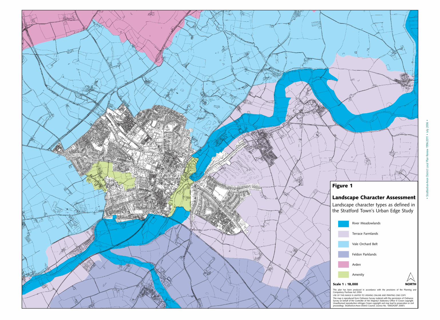
Figure 1
Landscape Character AssessmentLandscape character types as defined inthe Stratford Town’s Urban Edge Study
Scale 1 : 18,000 NORTH
This plan has been produced in accordance with the provisions of the Planning andCompulsory Purchase Act 2004.USE OF THIS IMAGE IS LIMITED TO VIEWING ON-LINE AND PRINTING ONE COPY.
This map is reproduced from Ordnance Survey material with the permission of OrdnanceSurvey on behalf of the Controller of Her Majesty’s Stationery Office © Crown copyright.Unauthorised reproduction infringes Crown copyright and may lead to prosecution or civilproceedings. Stratford-on-Avon District Council, Licence No. 100024287 2000’s
River Meadowlands
Terrace Farmlands
Vale Orchard Belt
Feldon Parklands
Arden
Amenity


![Trait Theory SOU Example[1]](https://static.fdocuments.in/doc/165x107/577d22611a28ab4e1e9739da/trait-theory-sou-example1.jpg)