OGT TERMS Ohio Graduation Test A Glossary of Terms TERMS 72-81.
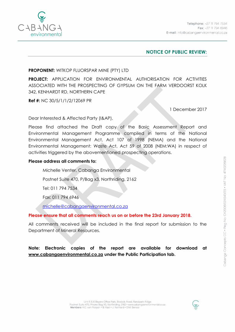
NOTICE OF PUBLIC REVIEW:
PROPONENT: WITKOP FLUORSPAR MINE (PTY) LTD
PROJECT: APPLICATION FOR ENVIRONMENTAL AUTHORISATION FOR ACTIVITIES
ASSOCIATED WITH THE PROSPECTING OF GYPSUM ON THE FARM VERDOORST KOLK
342, KENHARDT RD, NORTHERN CAPE
Ref #: NC 30/5/1/1/2/12069 PR
1 December 2017
Dear Interested & Affected Party (I&AP),
Please find attached the Draft copy of the Basic Assessment Report and
Environmental Management Programme compiled in terms of the National
Environmental Management Act, Act 107 of 1998 (NEMA) and the National
Environmental Management: Waste Act, Act 59 of 2008 (NEM:WA) in respect of
activities triggered by the abovementioned prospecting operations.
Please address all comments to:
Michelle Venter, Cabanga Environmental
Postnet Suite 470, P/Bag x3, Northriding, 2162
Tel: 011 794 7534
Fax: 011 794 6946
Please ensure that all comments reach us on or before the 23rd January 2018.
All comments received will be included in the final report for submission to the
Department of Mineral Resources.
Note: Electronic copies of the report are available for download at
www.cabangaenvironmental.co.za under the Public Participation tab.
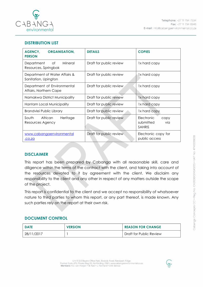
DISTRIBUTION LIST
AGENCY, ORGANISATION,
PERSON
DETAILS COPIES
Department of Mineral
Resources, Springbok
Draft for public review 1x hard copy
Department of Water Affairs &
Sanitation, Upington
Draft for public review 1x hard copy
Department of Environmental
Affairs, Northern Cape
Draft for public review 1x hard copy
Namakwa District Municipality Draft for public review 1x hard copy
Hantam Local Municipality Draft for public review 1x hard copy
Brandvlei Public Library Draft for public review 1x hard copy
South African Heritage
Resources Agency
Draft for public review Electronic copy
submitted via
SAHRIS
www.cabangaenvironmental
.co.za
Draft for public review Electronic copy for
public access
DISCLAIMER
This report has been prepared by Cabanga with all reasonable skill, care and
diligence within the terms of the contract with the client, and taking into account of
the resources devoted to it by agreement with the client. We disclaim any
responsibility to the client and any other in respect of any matters outside the scope
of the project.
This report is confidential to the client and we accept no responsibility of whatsoever
nature to third parties to whom this report, or any part thereof, is made known. Any
such parties rely on the report at their own risk.
DOCUMENT CONTROL
DATE VERSION REASON FOR CHANGE
28/11/2017 1 Draft for Public Review
BASIC ASSESSMENT REPORT
AND
ENVIRONMENTAL MANAGEMENT PROGRAMME REPORT
SUBMITTED FOR ENVIRONMENTAL AUTHORIZATIONS IN TERMS OF THE NATIONAL
ENVIRONMENTAL MANAGEMENT ACT, 1998 AND THE NATIONAL ENVIRONMENTAL
MANAGEMENT WASTE ACT, 2008 IN RESPECT OF LISTED ACTIVITIES THAT HAVE BEEN
TRIGGERED BY APPLICATIONS IN TERMS OF THE MINERAL AND PETROLEUM RESOURCES
DEVELOPMENT ACT, 2002 (MPRDA) (AS AMENDED).
NAME OF APPLICANT: Witkop Fluorspar Mine (Pty) Ltd
TEL NO: 021 880 1170
FAX NO: 086 010 3516
POSTAL ADDRESS: PO Box 688, Stellenbosch, 7599
PHYSICAL ADDRESS: 2nd Floor, A-Block, Octo Place, Electron Avenue,
Technopark, Stellenbosch
FILE REFERENCE NUMBER SAMRAD: NC 30/5/1/1/2/12069 PR

Verdoorst Kolk Prospecting BAR & EMP November 2017
i
Important Notice
In terms of the Mineral and Petroleum Resources Development Act (Act 28 of 2002
as amended), the Minister must grant a prospecting or mining right if among others
the mining “will not result in unacceptable pollution, ecological degradation or
damage to the environment”.
Unless an Environmental Authorisation can be granted following the evaluation of
an Environmental Impact Assessment and an Environmental Management
Programme report in terms of the National Environmental Management Act (Act 107
of 1998) (NEMA), it cannot be concluded that the said activities will not result in
unacceptable pollution, ecological degradation or damage to the environment.
In terms of section 16(3) (b) of the EIA Regulations, 2014, any report submitted as part
of an application must be prepared in a format that may be determined by the
Competent Authority and in terms of section 17 (1) (c) the competent Authority must
check whether the application has taken into account any minimum requirements
applicable or instructions or guidance provided by the competent authority to the
submission of applications.
It is therefore an instruction that the prescribed reports required in respect of
applications for an environmental authorisation for listed activities triggered by an
application for a right or a permit are submitted in the exact format of, and provide
all the information required in terms of, this template. Furthermore please be advised
that failure to submit the information required in the format provided in this template
will be regarded as a failure to meet the requirements of the Regulation and will
lead to the Environmental Authorisation being refused.
It is furthermore an instruction that the Environmental Assessment Practitioner must
process and interpret his/her research and analysis and use the findings thereof to
compile the information required herein. (Unprocessed supporting information may
be attached as appendices). The EAP must ensure that the information required is
placed correctly in the relevant sections of the Report, in the order, and under the
provided headings as set out below, and ensure that the report is not cluttered with
un-interpreted information and that it unambiguously represents the interpretation of
the applicant.
Verdoorst Kolk Prospecting BAR & EMP November 2017
ii
Objective of the basic assessment process
The objective of the basic assessment process is to, through a consultative process─
(a) determine the policy and legislative context within which the proposed
activity is located and how the activity complies with and responds to the
policy and legislative context;
(b) identify the alternatives considered, including the activity, location, and
technology alternatives;
(c) describe the need and desirability of the proposed alternatives,
(d) through the undertaking of an impact and risk assessment process inclusive of
cumulative impacts which focused on determining the geographical,
physical, biological, social, economic, heritage , and cultural sensitivity of the
sites and locations within sites and the risk of impact of the proposed activity
and technology alternatives on the these aspects to determine:
(i) the nature, significance, consequence, extent, duration, and
probability of the impacts occurring to; and
(ii) the degree to which these impacts—
a) can be reversed;
b) may cause irreplaceable loss of resources; and
c) can be managed, avoided or mitigated;
(e) through a ranking of the site sensitivities and possible impacts the activity and
technology alternatives will impose on the sites and location identified
through the life of the activity to—
(i) identify and motivate a preferred site, activity and technology
alternative;
(ii) identify suitable measures to manage, avoid or mitigate identified
impacts; and
(iii) identify residual risks that need to be managed and monitored.

Verdoorst Kolk Prospecting BAR & EMP November 2017
iii
LIST OF ACRONYMS
Acronym Expanded Name
AEL Atmospheric Emission License in terms of NEM:AQA
BAR Basic Assessment Report
BID Background Information Documents
CARA Conservation of Agricultural Resources Act (Act 43 of 1983) as amended
COP Codes of Practice
DMR Department of Mineral Resources
DWS Department of Water Affairs and Sanitation
EA Environmental Authorisation in terms of NEMA
EAP Environmental Assessment Practitioner
ECA Environmental Conservation Act (Act 73 of 1989) as amended
EIA Environmental Impact Assessment (process or report)
EIA
Regulation Environmental Impact Assessment Regulation published under NEMA
EMP Environmental Management Programme
GDP Gross Domestic Product
GIS Geographical Information Systems
GN General Notice (issued under an Act, providing notice or information)
GNR General Notice Regulation (issued under an Act, providing instruction)
I&AP Interested and Affected Parties
IAIA SA International Association of Impact Assessment South Africa
MHSA Mine Health and Safety Act (Act 29 of 1996) as amended
MPRDA
Mineral and Petroleum Resources Development Act (Act 28 of 2002) as
amended
MR Mining Right in terms of the MPRDA
MRA Mining Right Application in terms of the MPRDA
NAEIS National Atmospheric Emissions Inventory System
NEM:AQA
National Environmental Management: Waste Act (Act 39 of 2004) as
amended
NEM:BA
National Environmental Management: Biodiversity Act (Act 10 of 2004) as
amended
NEM:PAA
National Environmental Management: Protected Areas Act (Act 57 of 2003)
as amended
NEM:WA
National Environmental Management: Air Quality Act (act 59 of 2008) as
amended
NEMA National Environmental Management Act (Act 107 of 1998) as amended
Verdoorst Kolk Prospecting BAR & EMP November 2017
iv
NFEPA National Freshwater Ecology Priority Areas
NHRA National Heritage Resources Act (Act No. 25 of 1999) as amended
NPAES National Protected Area Expansion Strategy
NWA National Water Act (Act 35 of 1998) as amended
PPP Public Participation Process
PRA Prospecting Right Application in terms of the MPRDA
PR Prospecting Right in terms of the MPRDA
PWP Prospecting Work Programme
RoD Record of Decision (for specific application)
S&LP Social and Labour Plan
SACNASP South African Council for Natural Scientific Professions
SAHRA South African Heritage Resource Agency
SAMRAD South African Mineral Resources Administration System
SANBI South African National Biodiversity Institute
SANS South African National Standard (followed by standard number)
SAWIS South African Waste Information System
SEMA Specific Environmental Management Acts
SOP Standard Operating Procedure
SPLUMA Spatial Planning and Land Use Management Act (Act No.16 of 2013)
Stats SA Statistics South Africa
WMA Water Management Area
WML Waste Management Licence in terms of NEM:WA

Verdoorst Kolk Prospecting BAR & EMP November 2017
v
TABLE OF CONTENTS
LIST OF ACRONYMS ................................................................................................................. iii
1 INTRODUCTION ................................................................................................................. 1
2 CONTACT DETAILS ............................................................................................................ 1
2.1 Proponent ...................................................................................................................... 1
2.2 Environmental Assessment Practitioner ..................................................................... 2
2.3 Expertise & Experience of the EAP Project Team ..................................................... 2
3 LOCATION OF THE OVERALL ACTIVITY ........................................................................... 3
4 LOCALITY MAP .................................................................................................................. 3
5 DESCRIPTION OF THE OVERALL ACTIVITY ....................................................................... 8
5.1 Listed Activities to be undertaken .............................................................................. 8
5.2 Description of the activities to be undertaken ....................................................... 10
5.3 Prospecting Programme ........................................................................................... 10
5.4 Associated Activities, Infrastructure and Services ................................................. 15
6 POLICY AND LEGISLATIVE CONTEXT ............................................................................. 15
7 NEED AND DESIRABILITY OF THE PROPOSED ACTIVITIES ............................................. 20
8 MOTIVATION FOR THE OVERALL PREFERRED SITE, ACTIVITIES, AND TECHNOLOGY
ALTERNATIVE ........................................................................................................................... 21
9 DETAILS OF THE DEVELOPMENT FOOTPRINT ALTERNATIVES CONSIDERED ............... 21
9.1 Property/Location Alternatives ................................................................................. 21
9.2 The Type of Activity to be Undertaken .................................................................... 21
9.3 The Design or Layout of the Activity ........................................................................ 21
9.4 The Technology to be Used in the Activity; ............................................................ 22
9.5 The Operational Aspects of the Activity ................................................................. 22
9.6 The No-Go Alternative ............................................................................................... 22
10 DETAILS OF THE PUBLIC PARTICIPATION PROCESS FOLLOWED ............................. 23
10.1 Details of the PPP followed to Date ......................................................................... 26
10.2 Summary of Issues Raised by I&APs ......................................................................... 28
11 THE ENVIRONMENTAL ATTRIBUTES ASSOCIATED WITH THE SITES ............................. 33
11.1 Baseline Environment ................................................................................................. 33
Verdoorst Kolk Prospecting BAR & EMP November 2017
vi
11.1.1 Geology ................................................................................................................... 33
11.1.2 Landscape Characteristics ................................................................................... 33
11.1.3 Climate ..................................................................................................................... 34
11.1.4 Hydrology ................................................................................................................. 35
11.1.5 Soils ............................................................................................................................ 37
11.1.6 Land Capability ...................................................................................................... 39
11.1.7 Fauna (TBC, 2017) ................................................................................................... 39
11.1.8 Flora (TBC, 2017) ...................................................................................................... 41
11.1.9 Wetlands (Cabanga, 2017) ................................................................................... 43
11.1.10 Cultural Heritage(Archaetnos, 2017) ................................................................ 47
11.1.11 Palaeontological Setting (Bamford, 2017) ...................................................... 50
11.1.12 Socio-economic .................................................................................................. 50
11.2 Description of the Current Land Use. ....................................................................... 51
11.3 Description of Specific Environmental Features and Infrastructure on the site. 51
11.4 Environmental and Current Land Use Map ............................................................ 53
11.5 Impacts and Risks Identified including the Nature, Significance, Consequence,
Extent, Duration and Probability of the Impacts ............................................................... 53
11.6 Methodology used in Determining and Ranking the Nature, Significance,
Consequences, Extent, Duration and Probability of Potential Environmental Impacts
and Risks; ................................................................................................................................. 57
11.7 The Positive and Negative Impacts that the Proposed Activity (in terms of the
initial site layout) and Alternatives will have on the Environment and the Community
that may be Affected ........................................................................................................... 58
11.8 The Possible Mitigation Measures that could be Applied and the Level of Risk59
11.9 Motivation where No Alternative Sites were Considered ..................................... 59
11.10 Statement Motivating the Alternative Development Location within the
Overall Site .............................................................................................................................. 59
11.11 Full Description of the Process Undertaken to Identify, Assess and Rank the
Impacts and Risks the Activity will Impose on the Preferred Site (In respect of the final
site layout plan) through the life of the activity. ............................................................... 59
11.12 Assessment of Each Identified Potentially Significant Impact and Risk .......... 60
11.13 Summary of Specialist Reports .............................................................................. 67

Verdoorst Kolk Prospecting BAR & EMP November 2017
vii
11.14 Environmental impact statement ......................................................................... 72
11.14.1 Summary of the key findings of the environmental impact assessment; .... 72
11.15 Final Site Map .......................................................................................................... 72
11.16 Summary of the Positive and Negative Implications and Risks of the
Proposed Activity and Identified Alternatives ................................................................... 74
12 PROPOSED IMPACT MANAGEMENT OBJECTIVES AND OUTCOME FOR
INCLUSION IN THE EMP .......................................................................................................... 78
13 ASPECTS FOR INCLUSION IN THE CONDITIONS OF AUTHORISATION ..................... 79
14 ASSUMPTIONS, UNCERTAINTIES AND GAPS IN KNOWLEDGE ................................. 79
15 REASONED OPINION AS TO WHETHER THE PROPOSED ACTIVITY SHOULD OR
SHOULD NOT BE AUTHORISED ............................................................................................... 81
16 PERIOD FOR WHICH ENVIRONMENTAL AUTHORISATION IS REQUIRED ................. 81
17 UNDERTAKING ............................................................................................................. 81
18 FINANCIAL PROVISION ............................................................................................... 81
18.1 Explain how the Aforesaid Amount was Derived .................................................. 81
18.2 Confirm that this Amount can be Provided for from Operating Expenditure ... 82
19 SPECIFIC INFORMATION REQUIRED BY THE COMPETENT AUTHORITY ................... 82
19.1 Compliance with the Provisions of Sections 24(4)(a) and (b) read with section
24 (3) (a) and (7) of the National Environmental Management Act (Act 107 of 1998).
The EIA report must include the:- ........................................................................................ 82
19.1.1 Impact on the socio-economic conditions of any directly affected person 82
19.1.2 Impact on any national estate referred to in section 3(2) of the National
Heritage Resources Act ........................................................................................................ 82
19.1.3 Other matters required in terms of sections 24(4)(a) and (b) of the Act. ....... 83
20 DETAILS OF THE EAP .................................................................................................... 84
21 DESCRIPTION OF THE ASPECTS OF THE ACTIVITY ..................................................... 84
22 COMPOSITE MAP ........................................................................................................ 84
23 DESCRIPTION OF IMPACT MANAGEMENT OBJECTIVES INCLUDING
MANAGEMENT STATEMENTS ................................................................................................. 84
23.1 Determination of Closure Objectives ...................................................................... 84
23.2 Volumes and Rate of Water Use Required for the Operation ............................. 84
Verdoorst Kolk Prospecting BAR & EMP November 2017
viii
23.3 Has a Water Use Licence has been Applied For ................................................... 84
23.4 Impacts to be Mitigated in their Respective Phases ............................................. 85
23.5 Impact Management Outcomes ............................................................................ 88
23.6 Impact Management Actions .................................................................................. 93
24 FINANCIAL PROVISION ............................................................................................... 97
24.1 Describe the closure objectives and the extent to which they have been
aligned to the baseline environment described under the Regulation. ....................... 97
24.2 Confirm specifically that the environmental objectives in relation to closure
have been consulted with landowner and interested and affected parties .............. 98
24.3 Provide a rehabilitation plan that describes and shows the scale and aerial
extent of the main mining activities, including the anticipated mining area at the
time of closure ....................................................................................................................... 98
24.4 Explain why it can be confirmed that the rehabilitation plan is compatible with
the closure objectives ........................................................................................................... 98
24.5 Calculate and state the quantum of the financial provision required to
manage and rehabilitate the environment in accordance with the applicable
guideline ................................................................................................................................. 99
24.6 Confirm that the financial provision will be provided as determined ................ 99
25 MECHANISMS FOR MONITORING COMPLIANCE .................................................. 100
Mechanisms for monitoring compliance with and performance assessment against
the environmental management programme and reporting thereon, including .... 100
Monitoring of Impact Management Actions ....................................................... 100
Monitoring and reporting frequency ..................................................................... 100
Responsible persons ................................................................................................. 100
Time period for implementing impact management actions ........................... 100
Mechanism for monitoring compliance ............................................................... 100
25.1 Indicate the frequency of the submission of the Performance Assessment
Report .................................................................................................................................... 101
26 ENVIRONMENTAL AWARENESS PLAN ..................................................................... 101
26.1 Manner in which the applicant intends to inform his or her employees of any
environmental risk which may result from their work ...................................................... 101
26.2 Manner in which risks will be dealt with in order to avoid pollution or the
Verdoorst Kolk Prospecting BAR & EMP November 2017
ix
degradation of the environment ...................................................................................... 101
27 SPECIFIC INFORMATION REQUIRED BY THE COMPETENT AUTHORITY ................. 102
28 UNDERTAKING ........................................................................................................... 102
LIST OF TABLES
Table 1: Affected Properties .................................................................................................. 3
Table 2: Listed and Specified Activities ................................................................................ 9
Table 3: Summary of Applicable Legislation ..................................................................... 16
Table 4: NEMA PPP requirements and PPP conducted to date ..................................... 23
Table 5: Issues & Response Table ......................................................................................... 29
Table 6: Monthly Rainfall Data (Source: South African Weather Service) ..................... 34
Table 7: Soil Chemistry Results .............................................................................................. 37
Table 8: List of Potential Impacts ......................................................................................... 54
Table 9: Environmental Impact Assessment Matrix ........................................................... 60
Table 10: Summary of Post Mitigation Significance .......................................................... 74
Table 11: Rehabilitation Rates.............................................................................................. 82
Table 12: Measures to rehabilitate the environment affected by undertaking the
listed activity ........................................................................................................................... 85
Table 13: Description of the impact management outcomes ....................................... 88
Table 14: Description of the impact management actions ............................................ 93
Table 15: Rehabilitation Cost Estimate ............................................................................... 99
LIST OF FIGURES
Figure 1: Regional Setting ....................................................................................................... 5
Figure 2: Local Setting ............................................................................................................. 6
Figure 3: Extent of the Prospecting Area .............................................................................. 7
Figure 4: Main activities associated with the prospecting programme .......................... 8
Figure 5: Example of a TLB mounted auger drill ................................................................ 11
Figure 6: Primary Drilling Programme – Location of Boreholes ........................................ 12
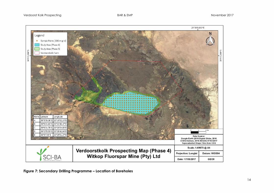
Figure 7: Secondary Drilling Programme – Location of Boreholes .................................. 14

Verdoorst Kolk Prospecting BAR & EMP November 2017
x
Figure 8: Regional Geology.................................................................................................. 33
Figure 9: Wind Rose – Brandvlei, Year Average (Source: South African Weather
Service) ................................................................................................................................... 35
Figure 10: Quaternary Catchments .................................................................................... 36
Figure 11: Mispah Soil Profile layout .................................................................................... 37
Figure 12: Soil deposition along the drainage channels on the western section of the
study area. .............................................................................................................................. 37
Figure 13: Soil profile layout .................................................................................................. 38
Figure 14: Flat terrains within the study area north of the Pan ........................................ 39
Figure 15: Vegetation Types ................................................................................................. 42
Figure 16: NFEPA Wetlands and Rivers ................................................................................ 45
Figure 17: Wetland Delineation and Ecological Setting .................................................. 46
Figure 18: Cultural and Heritage Sites ................................................................................. 49
Figure 19: Terrestrial CBAs ..................................................................................................... 52
Figure 20: Land Cover ........................................................................................................... 53
Figure 21: Final Site Map ....................................................................................................... 73
LIST OF APPENDICES
Appendix A: Figures (A3 Format)
Appendix B: Curriculum Vitae of EAP Project Team
Appendix C: Acceptance of Prospecting Right
Appendix D: Proof of Consultation / Public Participation
Appendix E: Biodiversity Assessment
Appendix F: Wetland Ecological Assessment
Appendix G: Heritage Impact Assessment
Appendix H: Paleontological Impact Assessment
Verdoorst Kolk Prospecting BAR & EMP November 2017
1
PART A:
SCOPE OF ASSESSMENT AND BASIC ASSESSMENT REPORT
1 INTRODUCTION
Witkop Fluorspar Mine (Pty) Ltd (hereinafter referred to as Witkop) has submitted an
application for a Prospecting Right in terms of the Minerals and Petroleum Resources
Development Act, Act 28 of 2002 (MPRDA) over Portions 1, 2 and the Remaining
Extent of the farm Verdoorst Kolk No. 342, Kenhardt Rd, Northern Cape. The
application relates to the search for economically viable reserves of the industrial
mineral Gypsum by means of auger drilling.
The proposed prospecting operations will require authorisation in terms of the various
environmental legislation and as such an application for Environmental Authorisation
(“EA”) was submitted as per the requirements of the National Environmental
Management Act, Act No. 107 of 1998 (“NEMA”) and the NEM: Waste Act, Act No.
59 of 2008 (“NEM:WA”); read together with the MPRDA.
South African Law requires that the environmental and social impacts associated
with a proposed development be assessed to identify any potential negative and /
or positive consequences as result thereof. Following which, measures must be
proposed to avoid or minimise these impacts. As the application relates to listed
activities published in terms of Listing Notice 1 a Basic Assessment process is
applicable.
This report constitutes the Basic Assessment Report (BAR) and Environmental
Management Programme (EMP), and has been compiled for submission to the
Component Authority, being the Department of Mineral Resources (DMR).
2 CONTACT DETAILS
2.1 Proponent
Applicant Name: Witkop Fluorspar Mine (Pty) Ltd
Registration No.: 1972/006392/07
Contact Person: Dr Johannes J.C.Erasmus, Group Technical Manager
Telephone: +27(0) 21 880 1170
Fax: +27(0) 21 880 1172
E-mail: [email protected]
Postal Address: PO Box 688, Stellenbosch, 7599
Physical Address: 2nd Floor, A-Block, Octo Place, Electron Avenue,
Technopark, Stellenbosch
Verdoorst Kolk Prospecting BAR & EMP November 2017
2
2.2 Environmental Assessment Practitioner
Cabanga Environmental has been appointed by Witkop as the independent
Environmental Assessment Practitioners (EAP), responsible for the completing the BAR
and EMP for the proposed project. The contact particulars of the EAP are indicated
below.
EAP: Cabanga Environmental
(t/a Cabanga Concepts cc)
Telephone: + 27 11 794 7534
Fax: + 27 11 794 6946
E-mail: [email protected]
Postal Address: Postnet Suite 470, Private Bag x3, Northriding, 2162
Physical Address: Units 5 & 6 Beyers Office Park, Bosbok Road, Randpark Ridge
2.3 Expertise & Experience of the EAP Project Team
Name: Role: Qualification: Experience:
J.Barrett EAP (lead author) and
project manager
BSc. in Environmental
Management & Botany
Certificate in Project
Management
10 years
M.Venter EAP (contributing author)
and Public Participation
Officer
Cert.Sci.Nat
BSc. (Hons) Geography
7 years
K.van Rooyen Reviewing EAP Pr.Sci.Nat
MSc. in Geography,
specialising in the
environment & coal
discard dump
29 years
C.Wallington Wetland Ecologist Pr.Sci.Nat
BSc. (Hons) in Botany
and Environmental &
Geographical Sciences
4 years
S.Tsanga Agricultural Scientist BSc. Agricultural &
Natural Sciences
10 years
M.Swart,
KookGIS
GIS Specialist and Public
Participation Officer
Pr.Sci.Nat, Pr.GISc
MSc Geography
23 years
All of the above have worked on mineral and environmental applications under the
MPRDA, NEMA, NEM:WA and NEM:AQA for various mines and industries. Please refer
to Appendix B for copies of the relevant Curriculum Vitae.
Verdoorst Kolk Prospecting BAR & EMP November 2017
3
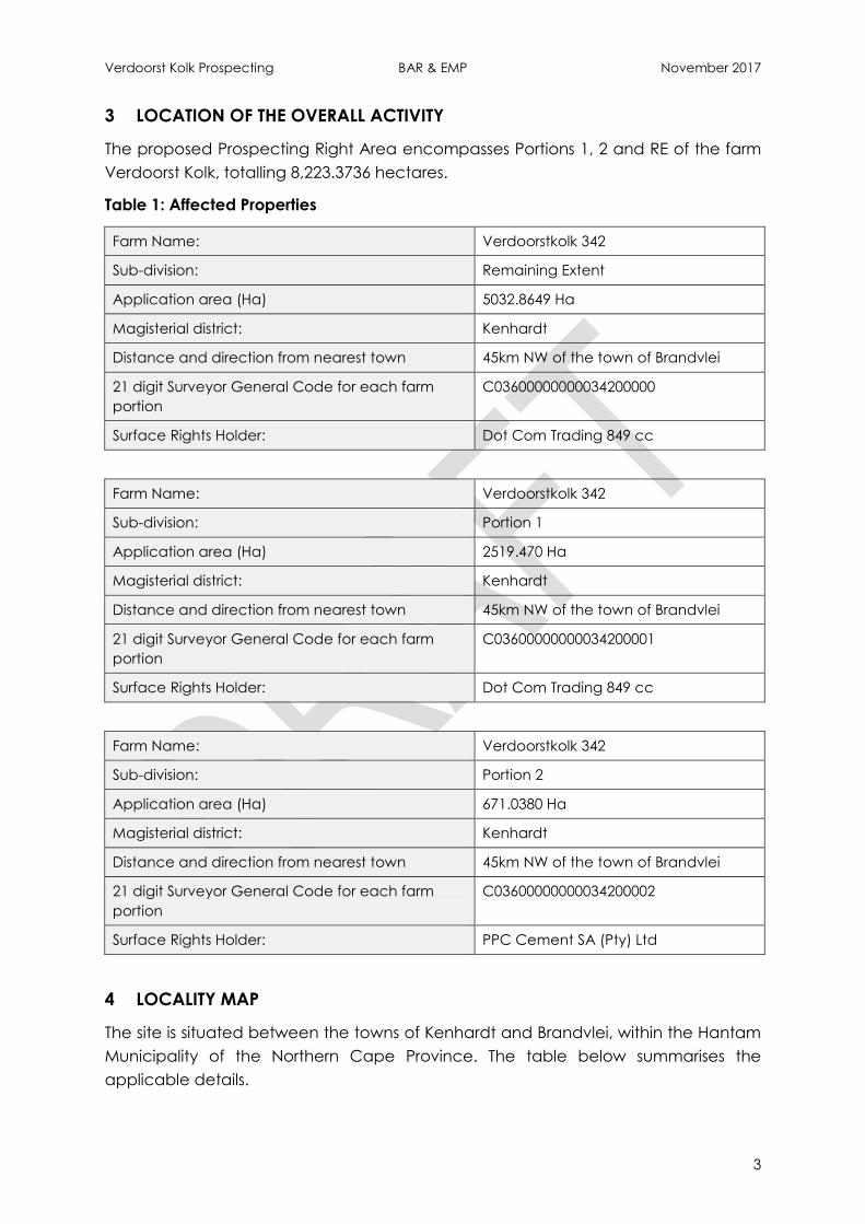
3 LOCATION OF THE OVERALL ACTIVITY
The proposed Prospecting Right Area encompasses Portions 1, 2 and RE of the farm
Verdoorst Kolk, totalling 8,223.3736 hectares.
Table 1: Affected Properties
Farm Name: Verdoorstkolk 342
Sub-division: Remaining Extent
Application area (Ha) 5032.8649 Ha
Magisterial district: Kenhardt
Distance and direction from nearest town 45km NW of the town of Brandvlei
21 digit Surveyor General Code for each farm
portion
C03600000000034200000
Surface Rights Holder: Dot Com Trading 849 cc
Farm Name: Verdoorstkolk 342
Sub-division: Portion 1
Application area (Ha) 2519.470 Ha
Magisterial district: Kenhardt
Distance and direction from nearest town 45km NW of the town of Brandvlei
21 digit Surveyor General Code for each farm
portion
C03600000000034200001
Surface Rights Holder: Dot Com Trading 849 cc
Farm Name: Verdoorstkolk 342
Sub-division: Portion 2
Application area (Ha) 671.0380 Ha
Magisterial district: Kenhardt
Distance and direction from nearest town 45km NW of the town of Brandvlei
21 digit Surveyor General Code for each farm
portion
C03600000000034200002
Surface Rights Holder: PPC Cement SA (Pty) Ltd
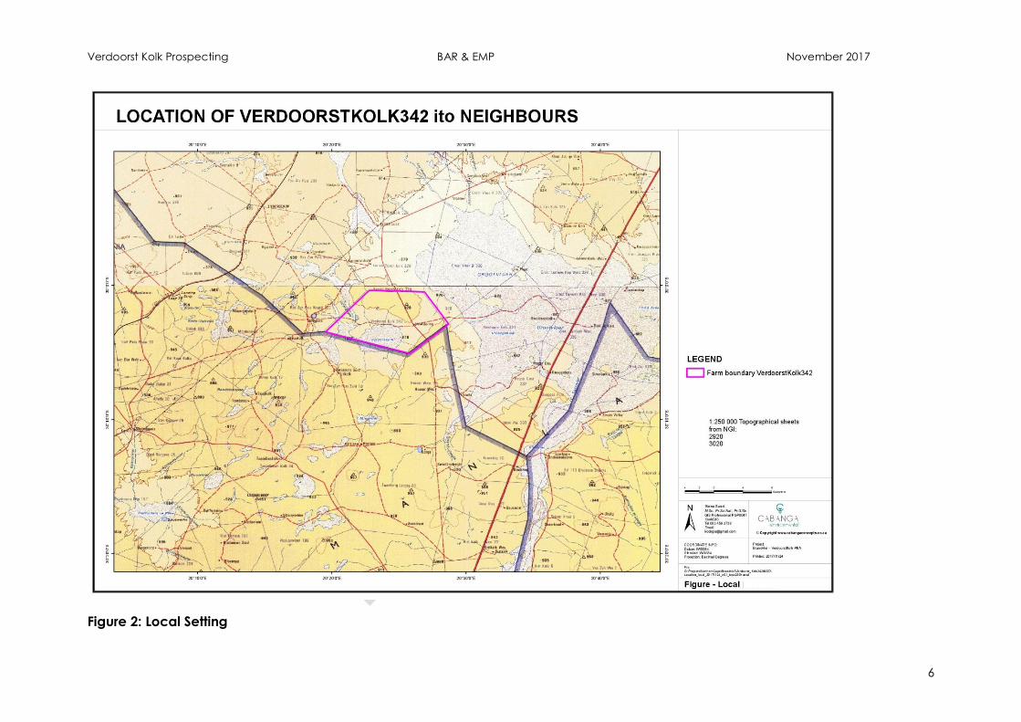
4 LOCALITY MAP
The site is situated between the towns of Kenhardt and Brandvlei, within the Hantam
Municipality of the Northern Cape Province. The table below summarises the
applicable details.

Verdoorst Kolk Prospecting BAR & EMP November 2017
4
Figures 1 and 2 below indicate the Regional and Local Setting of the project area.
Refer also to Appendix A for copies of the relevant figures in A3 format.

Verdoorst Kolk Prospecting BAR & EMP November 2017
5
Figure 1: Regional Setting
Verdoorst Kolk Prospecting BAR & EMP November 2017
6
Figure 2: Local Setting
Verdoorst Kolk Prospecting BAR & EMP November 2017
7
Figure 3: Extent of the Prospecting Area

Verdoorst Kolk Prospecting BAR & EMP November 2017
8
5 DESCRIPTION OF THE OVERALL ACTIVITY
This section outlines the relevant listed activities applicable to the project (Section
5.1) and gives a detailed project description (Section 5.2) of the activities associated
with the proposed prospecting.
5.1 Listed Activities to be undertaken
The Department of Environmental Affairs have published three notices listing
activities for which environmental authorisation is required in terms of Section 24(2)
and 24D of NEMA prior to commencement.
Furthermore, a list of waste management activities that have or are likely to have, a
detrimental effect on the environment were published in terms of section 19(2) of
the NEM:WA (GN 921 of 29 November 2013). No person may commence, undertake
or conduct a listed waste management activity unless a waste management
license (WML) is issued in respect of that activity.
The Department of Mineral Resources (DMR) is the Competent Authority for mineral
related activities in terms of both NEMA and NEM:WA. As such an integrated
application has been submitted as per the One Environmental System.
Figure 4 outlines the main activities associated with the proposed prospecting
programme, whilst Table 2 details the ancillary activities associated with the
proposed project, and identifies the applicable listed activities in terms of NEMA and
NEM:WA for which authorisation is being sought.
Figure 4: Main activities associated with the prospecting programme
Application Process
Non-Invasive Prospecting
(literature survey & target identification)
Primary Drilling & Sampling (50 holes)
Secondary Drilling & Sampling (200 holes)
Pre-feasiblity Studies
Verdoorst Kolk Prospecting BAR & EMP November 2017
9
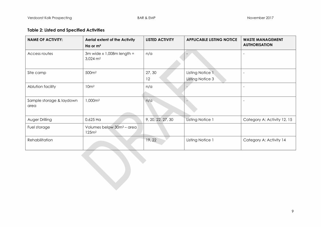
Table 2: Listed and Specified Activities
NAME OF ACTIVITY: Aerial extent of the Activity
Ha or m²
LISTED ACTIVITY APPLICABLE LISTING NOTICE
WASTE MANAGEMENT
AUTHORISATION
Access routes 3m wide x 1,008m length =
3,024 m2
n/a - -
Site camp 500m2
27, 30
12
Listing Notice 1
Listing Notice 3
-
Ablution facility
10m2
n/a - -
Sample storage & laydown
area
1,000m2
n/a - -
Auger Drilling 0.625 Ha 9, 20, 22, 27, 30 Listing Notice 1 Category A: Activity 12, 15
Fuel storage Volumes below 30m3 – area
125m2
Rehabilitation
19, 22 Listing Notice 1 Category A: Activity 14
Verdoorst Kolk Prospecting BAR & EMP November 2017
10
5.2 Description of the activities to be undertaken
This application relates to prospecting for the industrial mineral, Gypsum. Gypsum is
typically used in the agricultural and construction industries (plasterboard, Portland
cement, plaster etc.).
Prospecting activities will include non-invasive and invasive techniques; these are
further detailed below in Section 5.3 and 5.4. It is currently expected that the
prospecting programme will be completed over a 2 year period.
5.3 Prospecting Programme
Phase I: Application Process
Phase I constitutes the application process associated with obtaining the applicable
Rights, Permits and Authorisations.
Phase II: Desktop Investigations (non-invasive prospecting)
This phase will focus on research and information gathering to increase knowledge
and assist with mapping areas for future drilling. This Phase will include the review
and assessment of available aerial photographs, GIS maps, Google Earth imagery,
historic reports and studies of the area that might be available in the public domain
with regards to the history, geology, geohydrology, topography & drainage systems
and will specifically include available historic prospecting reports.
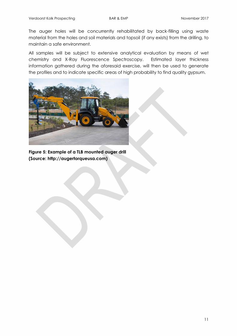
Phase III: Primary Drilling & Sampling
In this phase of the project, high-level lithostratigraphic profiles of the entire deposit
will be produced. . This will be achieved by reconnaissance mapping using existing
geological data of the area, surface sampling across the overall prospecting right
area, as well as wide-spaced drilling of 50 holes (30cm diameter) to a maximum of 5
meters deep, allowing access to both the powdery surface gypsum as well as the
secondary and older layer of crystalline gypsum, if any. The preliminary position of
these boreholes is indicated in Figure 6 below.
Drilling will be undertaken by means of a TLB-mounted auger drill. This technology is
ideal for drilling through unconsolidated alluvial deposits such as sands, silts and
clays. This method is considered a ‘dry’ drilling method, as no additives, such as
mud, are used during the drilling process.
The standout feature of this drilling method is that it makes use of three blades that
cut into the earth. The blades are attached to a hollow tube. This hollow tube takes
up the materials, which are loosened and is able to separate the samples from the
materials. In order for the samples to be effectively removed from the created hole,
air is compressed into the hole and the materials are blown up the hollow tube. The
samples are thus not damaged and can be easily analysed. This is one of the
features making this method of exploratory drilling stand out from percussion
rotary air blast drilling, which can sometimes cause damage to the samples that are
being extracted.
Verdoorst Kolk Prospecting BAR & EMP November 2017
11
The auger holes will be concurrently rehabilitated by back-filling using waste
material from the holes and soil materials and topsoil (if any exists) from the drilling, to
maintain a safe environment.
All samples will be subject to extensive analytical evaluation by means of wet
chemistry and X-Ray Fluorescence Spectroscopy. Estimated layer thickness
information gathered during the aforesaid exercise, will then be used to generate
the profiles and to indicate specific areas of high probability to find quality gypsum.
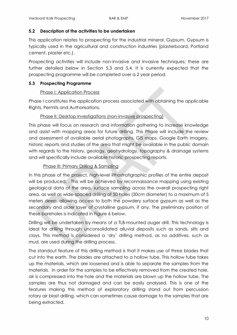
Figure 5: Example of a TLB mounted auger drill
(Source: http://augertorqueusa.com)
Verdoorst Kolk Prospecting BAR & EMP November 2017
12
Figure 6: Primary Drilling Programme – Location of Boreholes
Verdoorst Kolk Prospecting BAR & EMP November 2017
13
Phase IV: Secondary Drilling & Sampling
A secondary drilling programme will be executed on a 300 x 300 metre grid, limited
to selected areas based on the outcomes of the primary drilling and sampling
programme. It is expected that a maximum of approximately 1,800 hectares will be
subject to this detailed programme, calculating to approximately 200 auger-drilled
holes with a diameter of 30cm, to a maximum depth of 5 meters. As with Phase III, all
auger holes will be immediately rehabilitated.
This preliminary position of these holes is indicated in Figure 7 below, although it must
be noted that the geographic location shown is indicative only.
Equipment utilised onsite during Phases III and IV include:
TLB or backhoe loader;
Auger-torque drill attachment for TLB/backhoe loader;
20 ton excavator (only if required);
Private vehicles for transport of geologist and operators; and
Chemical analyses equipment (sample splitters, test sieves, bench top scale,
spectrometer etc.)
Phase V: Pre-feasibility Studies
The pre-feasibility study will combine the results of the overall prospecting
programme, constructing a geological model of the specific area that shows the
highest potential for mining. This model will provide information on the reserve
estimate and inform the initial mine plan layout.
The expected outcomes will include but not be limited to (i) analytical report of all
samples, (ii) deposit mapping in 3-dimensions with full analytical detail, (iii) reserve
calculation, (iv) preliminary trench mining design and future mining plan, (v) list of
potential mining and beneficiation equipment required and (vi) economic
evaluation and proposal to (or not to) proceed to a mining right.
Verdoorst Kolk Prospecting BAR & EMP November 2017
14
Figure 7: Secondary Drilling Programme – Location of Boreholes
Verdoorst Kolk Prospecting BAR & EMP November 2017
15
5.4 Associated Activities, Infrastructure and Services
Access Roads:
No formal roads will be constructed, existing farm roads and tracks will be utilised as
far as possible.
Site Camp:
A site camp and laydown area will be established on site for the storage of
equipment, samples etc. No staff will be housed on site.
Fuel Storage:
Diesel will be stored on site for use by the TLB; this will be erected within the site
camp and laydown area. It is currently expected that the storage volumes will
remain below 30m3.
Water Supply:
No water is required for the drilling process.
Water for potable use will be trucked and stored within a jojo tank. Alternatively
bottled water will be brought to site.
Waste Management
Bins will be provided on site, and waste collected for disposal at the licensed
Municipal site.
Chemical toilets (portable) will be erected on site, at the site camp and laydown
area.
6 POLICY AND LEGISLATIVE CONTEXT
Table 3 below summarises the Legislation and Guidelines considered to be
applicable to the proposed prospecting activities; and were considered at the time
of compiling this report.
Verdoorst Kolk Prospecting BAR & EMP November 2017
16
Table 3: Summary of Applicable Legislation
APPLICABLE LEGISLATION AND GUIDELINES
USED TO COMPILE THE REPORT
REFERENCE WHERE APPLIED HOW DOES THIS DEVELOPMENT COMPLY WITH AND
RESPOND TO THE POLICY AND LEGISLATIVE CONTEXT
The Constitution of South Africa, 1996 (Act 108
of 1996)
Everyone has the right to an
environment that is not harmful to their
health or well-being; to have the
environment protected for the benefit
of present and future generations,
through reasonable legislative and
other measures that prevent pollution
and ecological degradation; promote
conservation; and secure ecological
sustainable development and use of
natural resources while promoting
justifiable economic and social
development.
Every person has a right to information
held by the State and to information
held by other people that is required in
the exercise or protection of a right.
Everyone has the right to just and
procedurally fair administrative action.
This report.
Section 10 and Appendix
D.
Section 10 and Appendix
D.
A BAR process has been followed for the project
to determine the impact to the environment.
The BAR and EMP will be made available for
public review for a period of 30 days (minimum).
The Appeal Process will be described to I&APs
through the RoD notification process.
The Minerals and Petroleum Resources
Development Act (MPRDA), Act No. 28 of and
its Regulations (GNR527, 23 April 2004 as
amended by: GNR R1288 dated 29 October
2004; GNR1203 dated 30 November 2006; and
GNR349 dated 18 April 2011).
Acceptance letter included in
Appendix C.
An application for a prospecting right was
submitted to, and accepted by, the DMR in
terms of the MPRDA.
Submission of information has been on the
prescribed forms, and submitted via the
SAMRAD portal where applicable.

Verdoorst Kolk Prospecting BAR & EMP November 2017
17
APPLICABLE LEGISLATION AND GUIDELINES
USED TO COMPILE THE REPORT
REFERENCE WHERE APPLIED HOW DOES THIS DEVELOPMENT COMPLY WITH AND
RESPOND TO THE POLICY AND LEGISLATIVE CONTEXT
National Environmental Management Act
(NEMA), Act 107 of 1998 as amended and its
associated regulations: (GNR982 – EIA
Regulations; NEMA Regulation GNR983 – Listing
Notice 1; NEMA Regulation GNR984 – Listing
Notice 2; and NEMA Regulation GNR985 –
Listing Notice 3 as amended in 2017).
Table 2 Identifies the applicable
listed activities.
Witkop has submitted an application for EA. The
application is subject to BAR process.
NEMA: Public Participation Guidelines
(GNR807).
Section 10 and Appendix D.
Guidelines were followed during the Public
Participation Process (PPP).
NEMA Regulations pertaining to the financial
provision for prospecting, exploration, mining
or production activities (GNR1147 –20
November 2015).
Section 24 Financial Provision has been calculated and will
be provided for by means of an acceptable
guarantee.
National Environmental Management: Waste
Act (NEM:WA), Act 59 of 2008 as amended
and its associated regulations. The regulations
and various addendums pertaining to
scheduled waste activities (GNR921,
November 2013).
Table 2 identifies the applicable
Waste Management Activities.
Witkop has submitted an application for EA. The
application is subject to BAR process.
The definition of mine residue extends to waste
from drilling muds etc. As auger drilling is a “dry”
drilling method, minimal waste/drilling mud is
expected. Any clay/soils material generated will
be used to backfill and rehabilitate the auger
holes.
Norms and standards for the storage of waste
on site as per GNR926, November 2013.
Incorporated into the EMP Waste volumes generated on site will be
minimal, and is not expected to trigger
Category C.
The EMP has considered the norms and
standards for storage, where relevant.
National Water Act (NWA), Act 36 of 1998 as
amended and its associated regulations.
Incorporated into the EMP The focus area of the prospecting programme is
a large salt pan as such authorisation is required
in terms of the NWA, either through a GA or
Verdoorst Kolk Prospecting BAR & EMP November 2017
18
APPLICABLE LEGISLATION AND GUIDELINES
USED TO COMPILE THE REPORT
REFERENCE WHERE APPLIED HOW DOES THIS DEVELOPMENT COMPLY WITH AND
RESPOND TO THE POLICY AND LEGISLATIVE CONTEXT
water use license.
To date the DWS has been notified of the
acceptance of the Prospecting Right
Application as required by the Regulations
regarding the procedural .requirements for
water use license applications.
The necessary applications will be submitted to
the DWS in the near future.
GNR704 of the NWA, Regulations on the use of
water for mining and related activities aimed
at the protection of water resources.
Incorporated into the EMP The focus area of the prospecting programme is
a large salt pan, as such exemption will be
required from Regulation 4(b) of GN704.
To date the DWS has been notified of the
acceptance of the Prospecting Right
Application as required by the Regulations
regarding the procedural .requirements for
water use license applications.
The necessary applications will be submitted to
the DWS in the near future.
National Environmental Management:
Biodiversity Act (NEM:BA), Act 10 OF 2004 as
amended and its regulations, including various
regulations pertaining to protected species
and to alien and invasive species.
Table 2 Identifies the applicable
listed activities.
Regulations utilised to determine the need for
any listed scheduled activities under Listing
Notice 3. The majority of the project area is
classed as CBA1 and CBA2.
The alien invasive management system will
consider the listed alien and invasive species
published under NEM:BA as well as CARA and
preliminary plan included in the EMP.
National Environmental Management:
Protected Areas Act (NEMPAA), Act 57 of 2003
as amended and its associated regulations.
Appendix E. Formally protected areas refer to areas
protected either by national or provincial
legislation whereas informally protected areas
refers to privately owned reserves. No formally or
Verdoorst Kolk Prospecting BAR & EMP November 2017
19
APPLICABLE LEGISLATION AND GUIDELINES
USED TO COMPILE THE REPORT
REFERENCE WHERE APPLIED HOW DOES THIS DEVELOPMENT COMPLY WITH AND
RESPOND TO THE POLICY AND LEGISLATIVE CONTEXT
informally protected areas are situated in close
proximity to the project area. The nearest
protected area is Augrabies Falls National Park
which is situated approximately 180 km north of
the site.
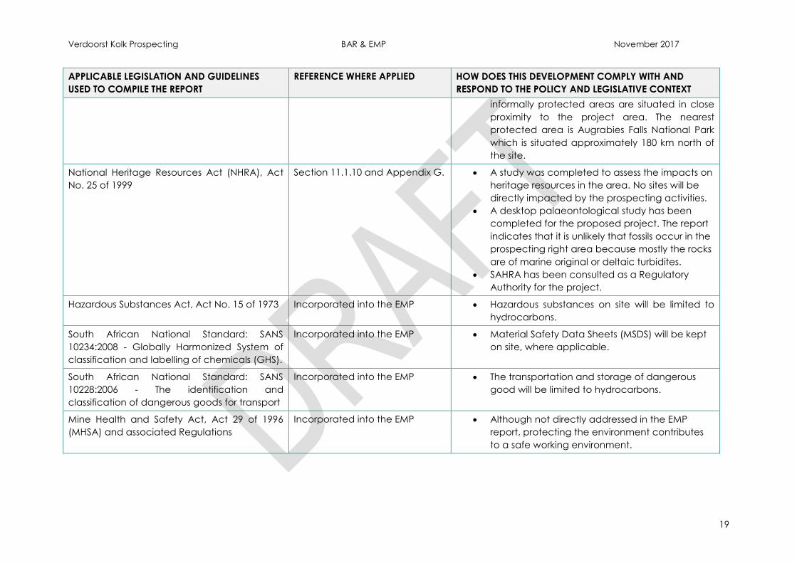
National Heritage Resources Act (NHRA), Act
No. 25 of 1999
Section 11.1.10 and Appendix G. A study was completed to assess the impacts on
heritage resources in the area. No sites will be
directly impacted by the prospecting activities.
A desktop palaeontological study has been
completed for the proposed project. The report
indicates that it is unlikely that fossils occur in the
prospecting right area because mostly the rocks
are of marine original or deltaic turbidites.
SAHRA has been consulted as a Regulatory
Authority for the project.
Hazardous Substances Act, Act No. 15 of 1973 Incorporated into the EMP Hazardous substances on site will be limited to
hydrocarbons.
South African National Standard: SANS
10234:2008 - Globally Harmonized System of
classification and labelling of chemicals (GHS).
Incorporated into the EMP Material Safety Data Sheets (MSDS) will be kept
on site, where applicable.
South African National Standard: SANS
10228:2006 - The identification and
classification of dangerous goods for transport
Incorporated into the EMP The transportation and storage of dangerous
good will be limited to hydrocarbons.
Mine Health and Safety Act, Act 29 of 1996
(MHSA) and associated Regulations
Incorporated into the EMP Although not directly addressed in the EMP
report, protecting the environment contributes
to a safe working environment.
Verdoorst Kolk Prospecting BAR & EMP November 2017
20
7 NEED AND DESIRABILITY OF THE PROPOSED ACTIVITIES
Gypsum is found in many arid regions of Southern Africa, where evaporation in saline
pans causes the mineral to crystalize (Cairncross, 2005). A large salt pan is situated
within the project area. Available geological data further indicates that area is
underlain by quaternary alluvium, comprising calcareous and gypsiferous soils,
followed by quaternary gravels, silts and sands.
In order to confirm the above, and determine the nature, location and extent of the
reserves, it is necessary to undertake prospecting. The prospecting programme will
further determine the economic viability of proceeding with mining in future. So
whilst the activity of prospecting will not greatly benefit the surrounding communities
or create employment, it will determine the feasibility of future mining prospects in
line with the MPRDA.
Creating employment opportunities and improving social infrastructure are
key goals set out in the Municipality’s Integrated Development Plan (IDP) and
the establishment of any future mine would provide job opportunities for the
surrounding areas.
The Rural Spatial Development Framework/Land Development Plan for the
Hantam Municipality dated 2010 has highlighted areas to the west of
Brandvlei for possible salt and gypsum mining.
During the prospecting activities, local services (drilling company, laboratory etc.)
will be utilised as far as possible.
Minimal services are required for the prospecting activities, these will be limited to
water, diesel and chemical toilet all of which will be brought onto site. Vehicles and
machinery will be limited to one TLB, one excavator and personal vehicles for
transporting the geologist and operators. Thus, no additional capacity will be
required from Municipal infrastructure in order to cater for the prospecting project.
The current land use can continue concurrent with the drilling activities.
In terms of environmental sensitivity:
The site has low agricultural potential.
The National Biodiversity Assessment, 2011 indicates the threat status of the
ecosystem as Least Threatened (LT) and not protected.
According to the C.A.P.E Fine Scale Biodiversity Planning Project (2009) the
pan area was classed as a terrestrial Critical Biodiversity Area (CBA) 2.
Subsequently in 2016, the Department of Environment and Nature
Conservation reviewed the CBA Map for Northern Cape and revised the
status of the pan to a terrestrial CBA1, with the surrounding areas being
classed as terrestrial CBA2.
No aquatic CBA or ESAs were identified on site or within the immediate area.
The pan and associated wetlands are classed as NFEPA Rank 2 wetlands of
National importance.

Verdoorst Kolk Prospecting BAR & EMP November 2017
21
However, given the nature of the proposed prospecting programme, impacts will
largely be limited to the footprint of the drill sites. Drilling will be conducted to a
maximum depth of 5m, with a diameter of 30cm using dry auger methods; all drill
sites will be rehabilitated concurrently. Thus all impacts associated with the proposed
prospecting project can be successfully mitigated if the EMP is correctly
implemented.
8 MOTIVATION FOR THE OVERALL PREFERRED SITE, ACTIVITIES, AND
TECHNOLOGY ALTERNATIVE
With regard to location, the prospecting activities are delimited by the properties
available for prospecting (i.e. not held by another company) and the geology of
the area. The preliminary positions of the proposed prospecting boreholes have
been sited to give a representative sample for the area of interest.
As mentioned earlier, Gypsum typically forms in the upper region of the weathering
profile in salt pans and in shales of the Ecca Group of the Karoo Supergroup. This
typically occurs in areas where evaporation rates are high and precipitation rates
are low. Thus, the Verdoorst Kolk pan forms the focus area of the prospecting
programme as this is where the mineral is most likely to be concentrated.
No activity alternatives are considered. Drilling is still the most effective way and an
industry norm to complete resource evaluation as required by the MPRDA.
Alternative drilling technology was considered (i.e. percussion rotary air blast drilling)
and dry auger drilling was determined to be the most beneficial.
9 DETAILS OF THE DEVELOPMENT FOOTPRINT ALTERNATIVES CONSIDERED
9.1 Property/Location Alternatives
Not applicable. Properties are delimited by the properties available for prospecting
(i.e. not held by another company); and the geology of the area.
9.2 The Type of Activity to be Undertaken
No activity alternatives are considered. Prospecting is a pre-requisite to mining and is
governed by legislative requirements for mining.
9.3 The Design or Layout of the Activity
No formal roads will be constructed; existing farm tracks will be used as far as
possible so as to reduce the environmental impacts. Thus no access or route
alternatives were considered.
Minimal surface infrastructure will be required this will include a small site camp and
laydown area for the storage of equipment and samples. This will be located outside
of all environmentally sensitive areas, in an area predetermined with the landowner.
Verdoorst Kolk Prospecting BAR & EMP November 2017
22
Accommodation will be provided for in one of the surrounding towns.
The preliminary positions of the proposed prospecting boreholes have been sited to
give a representative sample for the project area. These will however only be
finalised based on the findings of Phase II and III of the prospecting programme. The
use of desktop studies and literature reviews are viewed as an initial non-invasive
technique to delimit areas for invasive drilling prospecting and is seen as the most
responsible method to reduce needless surface disturbance and reduce
environmental impact footprint.
9.4 The Technology to be Used in the Activity;
Alternative drilling technology was considered (i.e. percussion rotary air blast drilling)
and dry auger drilling was determined to be the most beneficial.
Advantages and disadvantages associated with auger drilling are briefly discussed
below:
Advantages of Auger Drilling
Samples collected are a more accurate representation of what is below the
surface and this exploratory process often yields large pieces of samples,
which are easier to analyse and to get an accurate representation of the
deposit.
Holes do not need to be cased.
Drilling muds and water not required for drilling.
Movement of the machine between areas can be done quickly and easily.
The impact on the environment is minimal compared to other drilling
methods.
Disadvantages of Auger Drilling
Air core auger drilling can take longer than other methods.
The process is usually slightly more expensive than other methods.
9.5 The Operational Aspects of the Activity
Drilling is still the most effective way as well as an industry norm to complete resource
evaluation as required the MPRDA.
No alternatives were assessed.
9.6 The No-Go Alternative
The no-go option will result in the protection of the environment in situ. However, the
potential reserves may not be defined and ultimately utilised.
Ultimately, another company will apply for the Mineral Rights.

Verdoorst Kolk Prospecting BAR & EMP November 2017
23
10 DETAILS OF THE PUBLIC PARTICIPATION PROCESS FOLLOWED
Table 4 highlights the requirements for a public participation process (PPP) as per
NEMA and includes PPP carried out as part of this application process. Please see
the PPP report attached as Appendix D for the full details of the PPP carried out to
date.
The PPP aims to involve the authorities and I&APs in the project process, and
determines their needs, expectations and perceptions which in turn ensures a
complete and comprehensive environmental study. An open and transparent
process has and will be followed at all times and will be based on reciprocal
dissemination of information.
Table 4: NEMA PPP requirements and PPP conducted to date
Legal and Regulatory Requirement: NEMA Regulation 982, Section 41 – Public participation
process
1 This regulation only applies in instances where adherence to the provisions of this
regulation is specifically required
Noted
2 The person conducting a public participation process must take into account any
relevant guidelines applicable to public participation as contemplated in section
24J of the Act and must give notice to all potential interested and affected
parties of an application or proposed application which is subjected to public
participation b:
NEMA PPP Guidelines have been followed.
a fixing a notice board at a place conspicuous to and accessible by the public at
the boundary, on the fence or along the corridor of:
i the site where the activity to which the application or proposed application
relates is or is to be undertaken
ii An alternative site
Notices were compiled in English & Afrikaans and erected (7th and 8th November 2017) on
the site boundary fence as well as other public locations.
Copies of the Posters and photographic evidence thereof have been included in the
relevant Appendix of the PPP Report attached as Appendix D.
b giving written notice, in any of the manners provided for in section 47D of the Act,
to:
i the occupiers of the site and, if the proponent or applicant is not the owner or
person in control of the site on which the activity is to be undertaken, the owner or
person in control of the site where the activity is or is to be undertaken or to any
alternative site where the activity is to be undertaken;
ii owners, persons in control of, and occupiers of land adjacent to the site where
the activity is or is to be undertaken or to any alternative site where the activity is
to be undertaken;
Verdoorst Kolk Prospecting BAR & EMP November 2017
24
Legal and Regulatory Requirement: NEMA Regulation 982, Section 41 – Public participation
process
iii the municipal councillor of the ward in which the site or alternative site is situated
and any organisation of ratepayers that represent the community in the area;
iv the municipality which has jurisdiction in the area;
v any organ of state having jurisdiction in respect of any aspect of the activity; and
vi any other party as required by the Competent Authority.
A comprehensive database / I&AP register was compiled, this included various stakeholders,
authorities, land owners, land users and associations within the area.
Background Information Documents (BIDs), detailing the project, were compiled in English
and Afrikaans and circulated to all I&APs.
A copy of the BID and proof of delivery thereof is attached in the relevant Appendix of the
PPP Report included as Appendix D.
c Placing an advertisement in:
i One local newspaper; or
ii Any official Gazette that is published specifically for the purpose of providing
public notice of applications or other submissions made in terms of these
Regulations.
d placing an advertisement in at least one provincial newspaper or national
newspaper, if the activity has or may have an impact that extends beyond the
boundaries of the metropolitan or district municipality in which it is or will be
undertaken: Provided that this paragraph need not be complied with if an
advertisement has been placed in an official Gazette referred to in paragraph
(c)(ii)
Advertisements were placed in one (1) local newspapers, in both English and Afrikaans:
Noordwester, published on 10 November 2017
Copies of the Adverts are attached in the relevant Appendix of the PPP Report included as
Appendix D.
e Using reasonable alternative methods, as agreed to by the competent authority,
in those instances where a person is desirous of but unable to participate in the
process due to- (i) illiteracy; (ii) disability; or (iii) any other disadvantage.
No issues in information dissemination have been noted to date. Any additional requirements
made by the authorities will be applied during the PPP process.
3 A notice, notice board or advertisement referred to in sub regulation (2) must –
a Give details of the application which is subject to public participation
b State -
i whether basic assessment or S&EIR procedures are being applied to the
application
ii Whether basic assessment or scoping procedures are being applied to the
application, in the case of an application for environmental authorisation
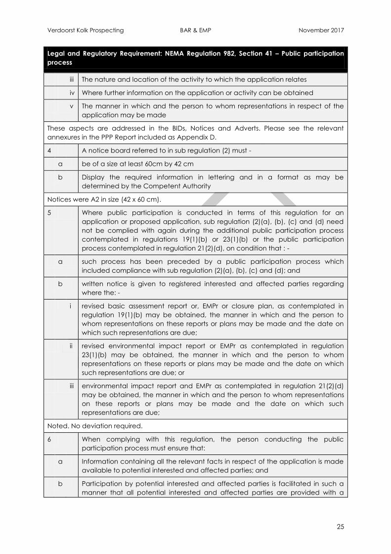
Verdoorst Kolk Prospecting BAR & EMP November 2017
25
Legal and Regulatory Requirement: NEMA Regulation 982, Section 41 – Public participation
process
iii The nature and location of the activity to which the application relates
iv Where further information on the application or activity can be obtained
v The manner in which and the person to whom representations in respect of the
application may be made
These aspects are addressed in the BIDs, Notices and Adverts. Please see the relevant
annexures in the PPP Report included as Appendix D.
4 A notice board referred to in sub regulation (2) must -
a be of a size at least 60cm by 42 cm
b Display the required information in lettering and in a format as may be
determined by the Competent Authority
Notices were A2 in size (42 x 60 cm).
5 Where public participation is conducted in terms of this regulation for an
application or proposed application, sub regulation (2)(a), (b), (c) and (d) need
not be complied with again during the additional public participation process
contemplated in regulations 19(1)(b) or 23(1)(b) or the public participation
process contemplated in regulation 21(2)(d), on condition that : -
a such process has been preceded by a public participation process which
included compliance with sub regulation (2)(a), (b), (c) and (d); and
b written notice is given to registered interested and affected parties regarding
where the: -
i revised basic assessment report or, EMPr or closure plan, as contemplated in
regulation 19(1)(b) may be obtained, the manner in which and the person to
whom representations on these reports or plans may be made and the date on
which such representations are due;
ii revised environmental impact report or EMPr as contemplated in regulation
23(1)(b) may be obtained, the manner in which and the person to whom
representations on these reports or plans may be made and the date on which
such representations are due; or
iii environmental impact report and EMPr as contemplated in regulation 21(2)(d)
may be obtained, the manner in which and the person to whom representations
on these reports or plans may be made and the date on which such
representations are due;
Noted. No deviation required.
6 When complying with this regulation, the person conducting the public
participation process must ensure that:
a Information containing all the relevant facts in respect of the application is made
available to potential interested and affected parties; and
b Participation by potential interested and affected parties is facilitated in such a
manner that all potential interested and affected parties are provided with a

Verdoorst Kolk Prospecting BAR & EMP November 2017
26
Legal and Regulatory Requirement: NEMA Regulation 982, Section 41 – Public participation
process
reasonable opportunity to comment on the application.
Noted.
The BAR and EMP will be made available for public review for a minimum of 30 days.
7 Where an environmental authorisation is required in terms of these Regulations
and an authorisation, permit or licence is required in terms of a specific
environmental management Act, the public participation process contemplated
in this Chapter may be combined with any public participation processes
prescribed in terms of a specific environmental management Act, on condition
that all relevant authorities agree to such combination of processes.
The PPP has been combined for all the authorisations required from the DMR in terms of the
MPRDA, NEMA and NEM:WA. The notices have also included information on the water uses
applicable under the NWA.
10.1 Details of the PPP followed to Date
Authorities Consultation:
The following Authorities have been identified and notified of the project by means
of Background Information Documents (BIDs) sent via fax, e-mail, post or hand
delivered:
DMR
DWS
Lower Orange Catchment Management Agency
Northern Cape Environmental Department
Northern Cape Agriculture, Land Reform and Rural Development
Namakwa District Municipality
Hantam Local Municipality
Northern Cape Heritage Authority
South African Heritage Resources Agency
Copies of the BAR and EMP have been delivered to the highlighted Authorities for
review and comment. All comments (where received) will be included in the I&AP
issues and response table below for submission to the DMR.
Interested and Affected Parties (I&APs) Consultation
The I&APs include a broad database of immediately affected landowners, adjacent
land owners/users, communities, local authorities, ward councillors and other interest
groups.
Background Information Documents (BIDs) were compiled in English and Afrikaans
and were distributed by hand, fax, e-mail and post to all the identified I&APs. In
addition the BID was uploaded onto the Cabanga website.
Verdoorst Kolk Prospecting BAR & EMP November 2017
27
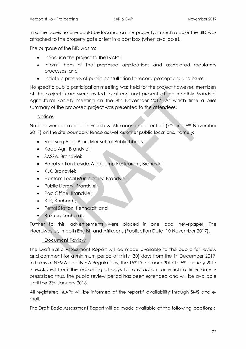
In some cases no one could be located on the property; in such a case the BID was
attached to the property gate or left in a post box (when available).
The purpose of the BID was to:
Introduce the project to the I&APs;
Inform them of the proposed applications and associated regulatory
processes; and
Initiate a process of public consultation to record perceptions and issues.
No specific public participation meeting was held for the project however, members
of the project team were invited to attend and present at the monthly Brandvlei
Agricultural Society meeting on the 8th November 2017. At which time a brief
summary of the proposed project was presented to the attendees.
Notices
Notices were compiled in English & Afrikaans and erected (7th and 8th November
2017) on the site boundary fence as well as other public locations, namely:
Voorsorg Vleis, Brandvlei Bethal Public Library;
Kaap Agri, Brandvlei;
SASSA, Brandvlei;
Petrol station beside Windpomp Restaurant, Brandvlei;
KLK, Brandvlei;
Hantam Local Municipality, Brandvlei;
Public Library, Brandvlei;
Post Office, Brandvlei;
KLK, Kenhardt;
Petrol Station, Kenhardt; and
Bazaar, Kenhardt.
Further to this, advertisements were placed in one local newspaper, The
Noordwester, in both English and Afrikaans (Publication Date: 10 November 2017).
Document Review
The Draft Basic Assessment Report will be made available to the public for review
and comment for a minimum period of thirty (30) days from the 1st December 2017.
In terms of NEMA and its EIA Regulations, the 15th December 2017 to 5th January 2017
is excluded from the reckoning of days for any action for which a timeframe is
prescribed thus, the public review period has been extended and will be available
until the 23rd January 2018.
All registered I&APs will be informed of the reports’ availability through SMS and e-
mail.
The Draft Basic Assessment Report will be made available at the following locations :

Verdoorst Kolk Prospecting BAR & EMP November 2017
28
Online at www.cabangaconcepts.co.za/public-documents; and
The Brandvlei Public Library.
10.2 Summary of Issues Raised by I&APs
It must be noted that the consultation process with I&APs is still on-going. All
comments (where received) will be included in the I&AP issues and response table
below for submission to the DMR.
Verdoorst Kolk Prospecting BAR & EMP November 2017
29
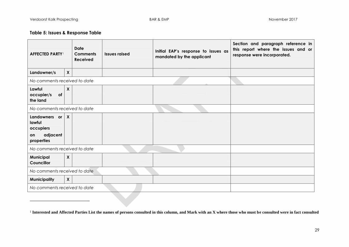
Table 5: Issues & Response Table
AFFECTED PARTY1
Date
Comments
Received
Issues raised Initial EAP’s response to issues as
mandated by the applicant
Section and paragraph reference in
this report where the issues and or
response were incorporated.
Landowner/s X
No comments received to date
Lawful
occupier/s of
the land
X
No comments received to date
Landowners or
lawful
occupiers
on adjacent
properties
X
No comments received to date
Municipal
Councillor
X
No comments received to date
Municipality X
No comments received to date
1 Interested and Affected Parties List the names of persons consulted in this column, and Mark with an X where those who must be consulted were in fact consulted
Verdoorst Kolk Prospecting BAR & EMP November 2017
30
AFFECTED PARTY1
Date
Comments
Received
Issues raised Initial EAP’s response to issues as
mandated by the applicant
Section and paragraph reference in
this report where the issues and or
response were incorporated.
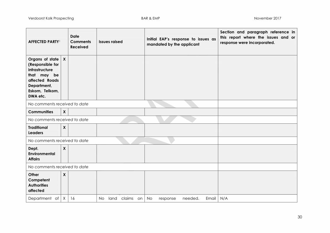
Organs of state
(Responsible for
infrastructure
that may be
affected Roads
Department,
Eskom, Telkom,
DWA etc.
X
No comments received to date
Communities X
No comments received to date
Traditional
Leaders
X
No comments received to date
Dept.
Environmental
Affairs
X
No comments received to date
Other
Competent
Authorities
affected
X
Department of X 16 No land claims on No response needed. Email N/A
Verdoorst Kolk Prospecting BAR & EMP November 2017
31
AFFECTED PARTY1
Date
Comments
Received
Issues raised Initial EAP’s response to issues as
mandated by the applicant
Section and paragraph reference in
this report where the issues and or
response were incorporated.
Rural
Development
and Land
Reform-
Nqabisa
Mkalipi/Ryan
Oliver
November
2017
Verdoorst Kolk Portion
Re, 1 and 2.
Factors that are
beyond the
Commission’s control:
Various factors
that some
claimants referred
to properties that
claim dispossession
of rights in land
against using
historical property
descriptions which
may not match
the current
property
description.
Some claimants
provided the
geographic
descriptions of the
land they claim
without mentioning
the particular
actual property
description they
received due to an inquiry emailed
to Department of Rural
Development and Land Reform.
Verdoorst Kolk Prospecting BAR & EMP November 2017
32
AFFECTED PARTY1
Date
Comments
Received
Issues raised Initial EAP’s response to issues as
mandated by the applicant
Section and paragraph reference in
this report where the issues and or
response were incorporated.
claim dispossession
of rights in land
against.
OTHER
AFFECTED
PARTIES
X
No comments received to date
INTERESTED
PARTIES
X
No comments received to date
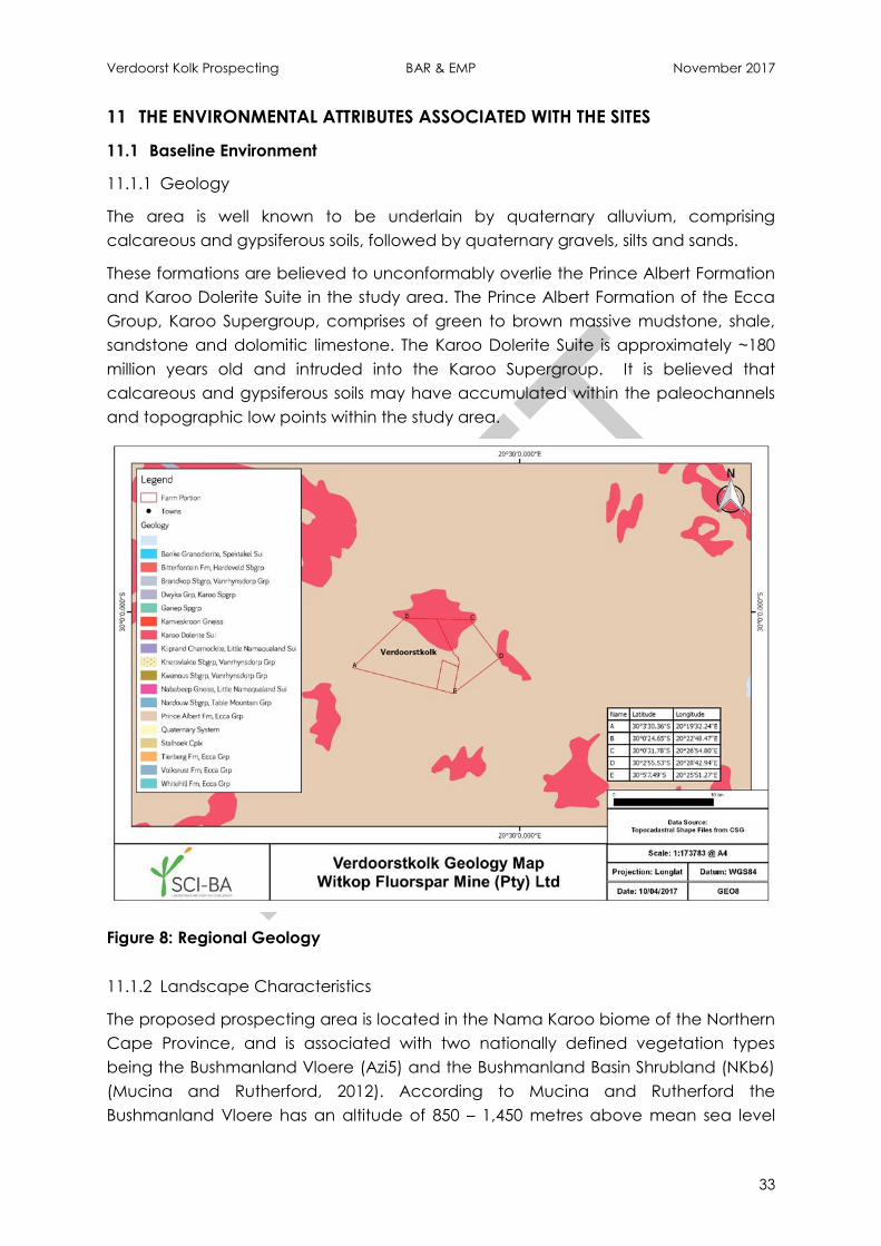
Verdoorst Kolk Prospecting BAR & EMP November 2017
33
11 THE ENVIRONMENTAL ATTRIBUTES ASSOCIATED WITH THE SITES
11.1 Baseline Environment
11.1.1 Geology
The area is well known to be underlain by quaternary alluvium, comprising
calcareous and gypsiferous soils, followed by quaternary gravels, silts and sands.
These formations are believed to unconformably overlie the Prince Albert Formation
and Karoo Dolerite Suite in the study area. The Prince Albert Formation of the Ecca
Group, Karoo Supergroup, comprises of green to brown massive mudstone, shale,
sandstone and dolomitic limestone. The Karoo Dolerite Suite is approximately ~180
million years old and intruded into the Karoo Supergroup. It is believed that
calcareous and gypsiferous soils may have accumulated within the paleochannels
and topographic low points within the study area.
Figure 8: Regional Geology
11.1.2 Landscape Characteristics
The proposed prospecting area is located in the Nama Karoo biome of the Northern
Cape Province, and is associated with two nationally defined vegetation types
being the Bushmanland Vloere (Azi5) and the Bushmanland Basin Shrubland (NKb6)
(Mucina and Rutherford, 2012). According to Mucina and Rutherford the
Bushmanland Vloere has an altitude of 850 – 1,450 metres above mean sea level
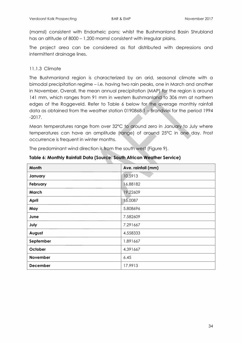
Verdoorst Kolk Prospecting BAR & EMP November 2017
34
(mamsl) consistent with Endorheic pans; whilst the Bushmanland Basin Shrubland
has an altitude of 8000 – 1,200 mamsl consistent with irregular plains.
The project area can be considered as flat distributed with depressions and
intermittent drainage lines.
11.1.3 Climate
The Bushmanland region is characterized by an arid, seasonal climate with a
bimodal precipitation regime – i.e. having two rain peaks, one in March and another
in November. Overall, the mean annual precipitation (MAP) for the region is around
141 mm, which ranges from 91 mm in western Bushmanland to 306 mm at northern
edges of the Roggeveld. Refer to Table 6 below for the average monthly rainfall
data as obtained from the weather station 0190868 1 – Brandvlei for the period 1994
-2017.
Mean temperatures range from over 32°C to around zero in January to July where
temperatures can have an amplitude (range) of around 25°C in one day. Frost
occurrence is frequent in winter months.
The predominant wind direction is from the south west (Figure 9).
Table 6: Monthly Rainfall Data (Source: South African Weather Service)
Month Ave. rainfall (mm)
January 10.5913
February 16.88182
March 19.22609
April 15.0087
May 5.808696
June 7.582609
July 7.291667
August 4.558333
September 1.891667
October 4.391667
November 6.45
December 17.9913
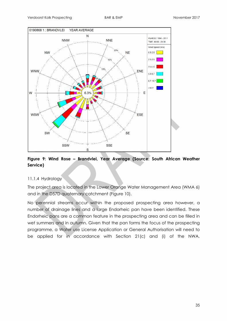
Verdoorst Kolk Prospecting BAR & EMP November 2017
35
Figure 9: Wind Rose – Brandvlei, Year Average (Source: South African Weather
Service)
11.1.4 Hydrology
The project area is located in the Lower Orange Water Management Area (WMA 6)
and in the D57D quaternary catchment (Figure 10).
No perennial streams occur within the proposed prospecting area however, a
number of drainage lines and a large Endorheic pan have been identified. These
Endorheic pans are a common feature in the prospecting area and can be filled in
wet summers and in autumn. Given that the pan forms the focus of the prospecting
programme, a Water use License Application or General Authorisation will need to
be applied for in accordance with Section 21(c) and (i) of the NWA.
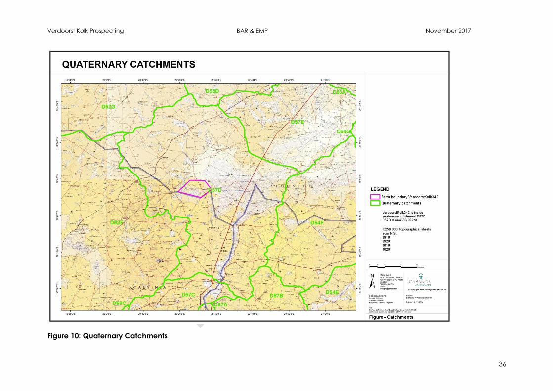
Verdoorst Kolk Prospecting BAR & EMP November 2017
36
Figure 10: Quaternary Catchments
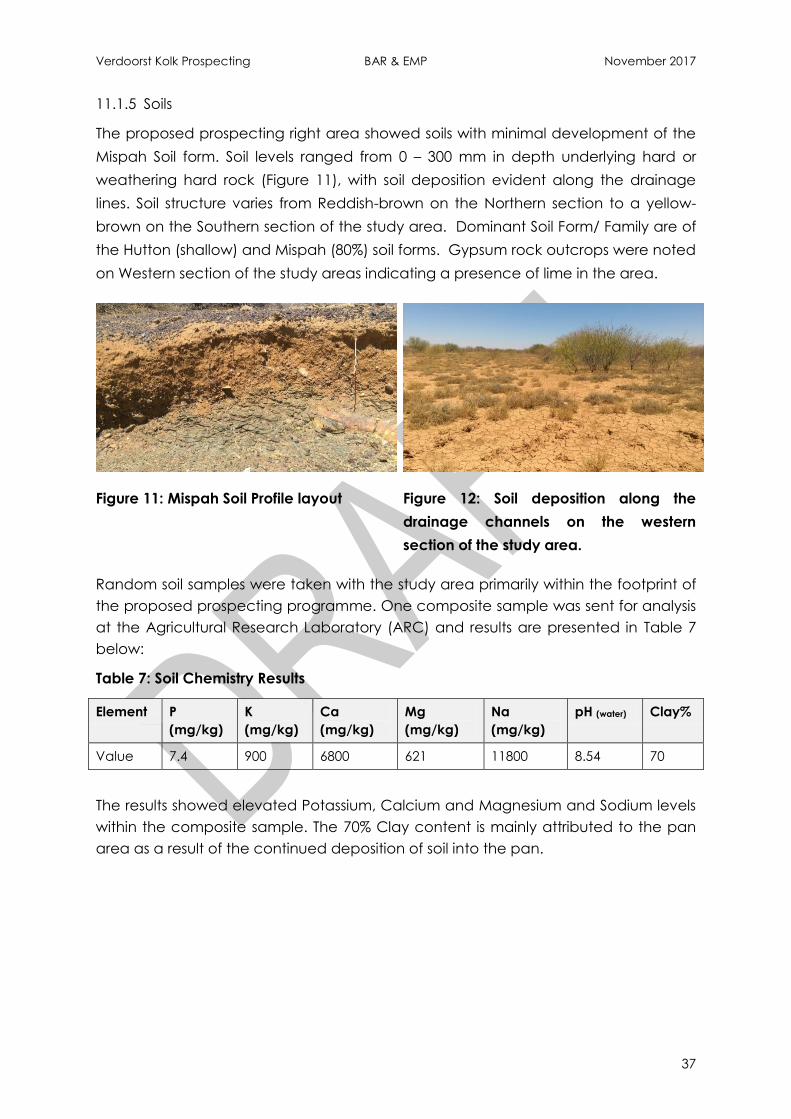
Verdoorst Kolk Prospecting BAR & EMP November 2017
37
11.1.5 Soils
The proposed prospecting right area showed soils with minimal development of the
Mispah Soil form. Soil levels ranged from 0 – 300 mm in depth underlying hard or
weathering hard rock (Figure 11), with soil deposition evident along the drainage
lines. Soil structure varies from Reddish-brown on the Northern section to a yellow-
brown on the Southern section of the study area. Dominant Soil Form/ Family are of
the Hutton (shallow) and Mispah (80%) soil forms. Gypsum rock outcrops were noted
on Western section of the study areas indicating a presence of lime in the area.
Figure 11: Mispah Soil Profile layout Figure 12: Soil deposition along the
drainage channels on the western
section of the study area.
Random soil samples were taken with the study area primarily within the footprint of
the proposed prospecting programme. One composite sample was sent for analysis
at the Agricultural Research Laboratory (ARC) and results are presented in Table 7
below:
Table 7: Soil Chemistry Results
Element P
(mg/kg)
K
(mg/kg)
Ca
(mg/kg)
Mg
(mg/kg)
Na
(mg/kg)
pH (water) Clay%
Value 7.4 900 6800 621 11800 8.54 70
The results showed elevated Potassium, Calcium and Magnesium and Sodium levels
within the composite sample. The 70% Clay content is mainly attributed to the pan
area as a result of the continued deposition of soil into the pan.

Verdoorst Kolk Prospecting BAR & EMP November 2017
38
Figure 13: Soil profile layout
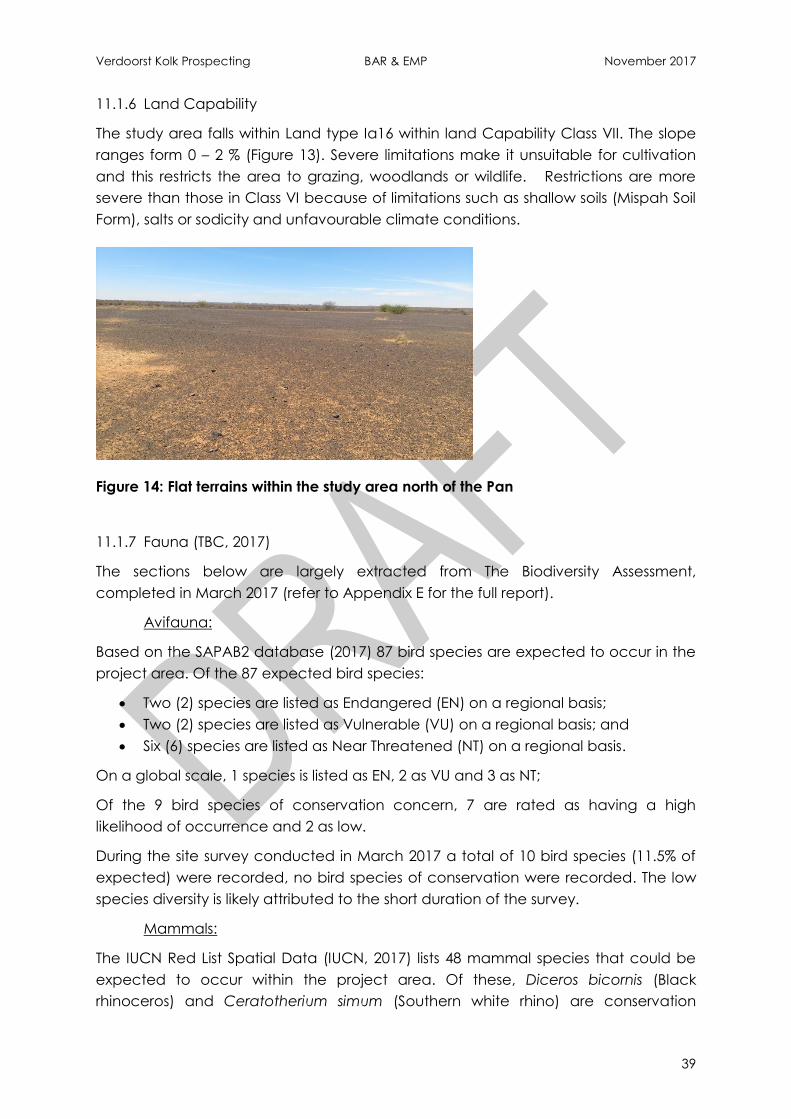
Verdoorst Kolk Prospecting BAR & EMP November 2017
39
11.1.6 Land Capability
The study area falls within Land type Ia16 within land Capability Class VII. The slope
ranges form 0 – 2 % (Figure 13). Severe limitations make it unsuitable for cultivation
and this restricts the area to grazing, woodlands or wildlife. Restrictions are more
severe than those in Class VI because of limitations such as shallow soils (Mispah Soil
Form), salts or sodicity and unfavourable climate conditions.
Figure 14: Flat terrains within the study area north of the Pan
11.1.7 Fauna (TBC, 2017)
The sections below are largely extracted from The Biodiversity Assessment,
completed in March 2017 (refer to Appendix E for the full report).
Avifauna:
Based on the SAPAB2 database (2017) 87 bird species are expected to occur in the
project area. Of the 87 expected bird species:
Two (2) species are listed as Endangered (EN) on a regional basis;
Two (2) species are listed as Vulnerable (VU) on a regional basis; and
Six (6) species are listed as Near Threatened (NT) on a regional basis.
On a global scale, 1 species is listed as EN, 2 as VU and 3 as NT;
Of the 9 bird species of conservation concern, 7 are rated as having a high
likelihood of occurrence and 2 as low.
During the site survey conducted in March 2017 a total of 10 bird species (11.5% of
expected) were recorded, no bird species of conservation were recorded. The low
species diversity is likely attributed to the short duration of the survey.
Mammals:
The IUCN Red List Spatial Data (IUCN, 2017) lists 48 mammal species that could be
expected to occur within the project area. Of these, Diceros bicornis (Black
rhinoceros) and Ceratotherium simum (Southern white rhino) are conservation
Verdoorst Kolk Prospecting BAR & EMP November 2017
40
dependant species that only occur in protected areas such as game reserves. These
species were omitted from the expected species list resulting in an expected
mammal list of 46 species.
Of the 46 expected mammal species:
3 (6.5%) are listed as species of conservation concern either regionally or
globally;
1 species is listed as CR, 1 as VU and 1 as NT on a regional scale. On a global
scale, 1 species is listed as CR and 1 as VU;
Of the 3 mammal species of conservation concern, 2 are rated as moderate
to highly likely to occur in the project area;
The following conclusions were reached based on the results of the field survey:
Mammal diversity was low. This was attributed to the short duration of the
survey and the lack of intensive sampling, trapping etc.;
No mammal species of conservation concern were observed during the
survey however Brown Hyaena (Parahyaena brunnea) was confirmed to be
present in the project area based on conversations with a local landowner.
Reptiles:
Based on the IUCN Red List Spatial Data (IUCN, 2017) and the Reptile Map database
provided by the Animal Demography Unit (ADU, 2017) 13 reptile species are
expected to occur in the project area. This includes 1 species namely Cape Sand
snake (Psammophis leightoni) which is listed as VU both on a regional and global
scale. Based on the distributional range of this species, which is primarily in the south-
western Cape, the likelihood of occurrence of the project area is low.
Only 1 reptile species was observed in the project area during the March 2017
survey, Trachylepis variegate (Variegated skin). A further 4 species were confirmed
to be present based on conversations with a local landowner, these include Naja
nivea (Cape cobra), Bitis arietans arietans (Puffadder), Bitis caudalis (Horned adder)
and Psammophis notostictus (Karoo sand snake). No reptile species of conservation
concern were recorded during the survey.
Amphibian
Based on the IUCN Red List Spatial Data (IUCN, 2017) and the Amphibian Map
database provided by the Animal Demography Unit (ADU, 2017) 6 amphibian
species are expected to occur in the project area. Of these species 1, namely Giant
bullfrog (Pyxicephalus adspersus) is listed as NT on a regional basis. The likelihood of
occurrence of this species in the project area is rated as good.
No amphibian species were recorded during the March 2017 survey. This was
attributed primarily to the short duration of the survey, as well as the dry conditions
recorded during the survey.

Verdoorst Kolk Prospecting BAR & EMP November 2017
41
11.1.8 Flora (TBC, 2017)
The proposed prospecting area is located in the Nama Karoo biome of the Northern
Cape Province, and is associated with two nationally defined vegetation types
being the Bushmanland Vloere (Azi5) and the Bushmanland Basin Shrubland (NKb6)
(Mucina and Rutherford, 2012) (see Figure 15). The Vloere of the Northern Cape refer
to the ephemeral pans and riverbeds of the Bushmanland basin, which represent
the wetland ecosystems of this arid area.
The floristic component and ecology of these Vloere are not well understood as it is
the least studied vegetation type in the country where the dominant succulent
shrub genus Salsola is pending taxonomic revision. However, in general the centre of
these pans (or the river drainage channel itself) are usually devoid of vegetation;
where loosely patterned scrub are found around it are dominated by Rhigozum
trichotomum and various species of Salsola and Lycium, with a mixture of no
succulent dwarf shrubs of Nama-Karoo relationship. In places loose thickets of
Parkinsonia africana, Lebeckia lineariifolia and Acacia karoo can be found (Mucina
and Rutherford, 2006).
A survey of the project area was completed in March 2017 by The Biodiversity
Company (refer to Appendix E for a copy of the full Biodiversity Assessment). During
the site survey vegetation cover was sparse and diversity low. A total of 8 plant
species were recorded in the prospecting focus area. No plant species of
conservation concern were recorded or are expected to occur.
The alien invasive plant species Prosopis glandulosa (Honey mesquite) was recorded
around the margin of Verdoorst Kolk. This multi-stemmed acacia-like shrub or small
tree has paired, straight spines and reddish-brown branchlets. Prosopis trees are
listed as Category 3 invasive species in the Northern Cape and are extravagant
users of readily available ground-water (Invasives.org, 2017).
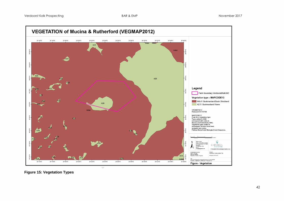
Verdoorst Kolk Prospecting BAR & EMP November 2017
42
Figure 15: Vegetation Types

Verdoorst Kolk Prospecting BAR & EMP November 2017
43
11.1.9 Wetlands (Cabanga, 2017)
The National Freshwater Ecosystem Priority Areas (NFEPA) project provides a
collated, nationally consistent information source of wetland and river ecosystems
for incorporating freshwater ecosystem and biodiversity goals into planning and
decision-making processes (Nel, et al., 2011). The spatial layers (FEPA’s) include the
nationally delineated wetland areas that are classified into Hydrogeomorphic
(HGM) types and ranked in terms of their biodiversity importance. This resource was
consulted to evaluate the importance of the wetlands identified within the project
area.
The pan associated with the study area as well as the drainage depression wetlands
leading to it are assessed to be Rank 2 (Figure 16), which indicates that the wetlands
are of very high national importance.
The wetland site visit was undertaken on 9th November 2017 to ground-truth the
above desktop findings and complete the ecological assessments. The wetland was
dry at the time of sampling and has been so for at least five years – these systems
are extremely ephemeral (intermittently wet). There are major limitations to
completing a wetland assessment in dry conditions; however, by using a
combination of detailed desktop review, in-field assessment, input from local land
owners and expert opinion, an ecological health assessment can be completed
with moderately high confident.
The nationally determined area of the wetland was found to be accurate; where
the pan is ~ 1,582 ha in extent within a catchment of approximately 73,000 ha. In
addition, there is a minimum of 800 ha of drainage wetlands found within this
catchment draining into the pan, these are classified as valley floor depressions
(Figure 17).
The pan was found to be in a near-pristine or natural condition . The main impact to
this area is two small old salt works at the eastern edge, which are still somewhat
intact despite being abandoned for approximately 10 and 30 years. There are some
farm tracks which traverse some areas of this pan and around it; however these are
not used very often and the farm occupants do not traverse over any other area of
the pan to avoid disturbing the vegetation. No alien invasive species are present
within the pan habitat but Prosopis glandulosa is present on the edges. Cattle
farming occurs on the edge of the pan which will have some small impact on the
pan and some evidence of cattle use of the pan was found. It can be concluded
that the pan ecosystem struggles to regenerate from any impact due to the
extreme climatic conditions; restoration of car tracks may occur during flood events.
The valley floor depression wetlands are in a largely natural condition (PES of B) with
mostly intact soils and vegetation; however more land uses have been applied in
these areas. The most widespread impact is the invasion of Prosopis glandulosa,
which is a tree from South America and a declared category 3 invader in the region
and thus should be actively removed from natural areas. The valley floor areas have

Verdoorst Kolk Prospecting BAR & EMP November 2017
44
also been dammed in many areas of which most are abandoned and broken. In
some areas there has been agricultural activities which in turn has led to local soil
disturbance and alteration of hydrological functioning. Again, most of these areas
are not in use and have not been for decades but the scars of the disturbance are
very clear due to passive restoration rates of these habitats being extremely slow in
this area.
These wetlands as a whole system can be given an area weighted PES of A/B being
largely natural. Both wetland units identified on site were determined to have their
greatest significance in their Ecological and Biodiversity roles in the ecosystem, with
the pan having an Ecological Important and Sensitivity (EIS) of Very High and the
drainage valley floor depressions being High. Given that these systems are the only
surface expression of water, albeit only in flood conditions, the hydrological and
human benefit is also of importance. The valley floor depressions particularly so, in
that they drain into and feed the pan and provide damming capabilities.

Verdoorst Kolk Prospecting BAR & EMP November 2017
45
Figure 16: NFEPA Wetlands and Rivers

Verdoorst Kolk Prospecting BAR & EMP November 2017
46
Figure 17: Wetland Delineation and Ecological Setting

Verdoorst Kolk Prospecting BAR & EMP November 2017
47
11.1.10 Cultural Heritage(Archaetnos, 2017)
Please refer to Appendix G for a copy of the Phase I Cultural and Heritage Impact
Assessment. The section below provides a brief summary of the cultural and heritage
sites identified within the project area. Noted: None of the sites will be directly
impacted on by the drilling programme.
A total of six (6) sites were identified within the proposed prospecting area (Figure
18):
Site 1: Graveyard
This is a fenced in graveyard, consisting of between four (4) to six (6) graves. Three of
which have headstones with legible names and dates, being:
Johannes van Rooyen, 12 September 1888 – 29 December 1954
Cecilia van Rooyen, born van Niekerk, was Burger, 14 March 1892 – 19
September 1968
S.C.Burger, 6 May 1891 – 26 December 1925
The fourth grave is stone packed and located just outside the outer fence. The last
two ‘graves’ consist of cement dressing, and communications with the farmer
(J.Bothma) indicate that at least one of these was only prepared, but never used.
Graves are always given a rating of high cultural significance due to it being a
sensitive matter. Graves with an unknown date are always handled as if older than
60 years. Graves older than 60 years are regarded as heritage graves.
The graves received a field rating of Local Grade IIIB.
Site 2: Graves
This is an unfenced graveyard consisting of at least three stone packed graves. Two
of these are smaller and likely represent children’s graves. The graves are poorly
preserved and no legible information is visible, these graves are therefore
considered to be unknown graves and must be handled similar to heritage graves.
The graves received a field rating of Local Grade IIIB.
Site 3: Graves
This is an unfenced graveyard consisting of at least three stone packed graves. Only
one has a headstone, but no legible information is visible. Glass and porcelain shards
are found in the surrounding area.
The graves are poorly preserved, these graves are therefore considered to be
unknown graves and must be handled similar to heritage graves.
The graves received a field rating of Local Grade IIIB.
Site 4: Historical Residential Remains
The site consists of a circle of stones with a diameter of approximately 6m, most likely
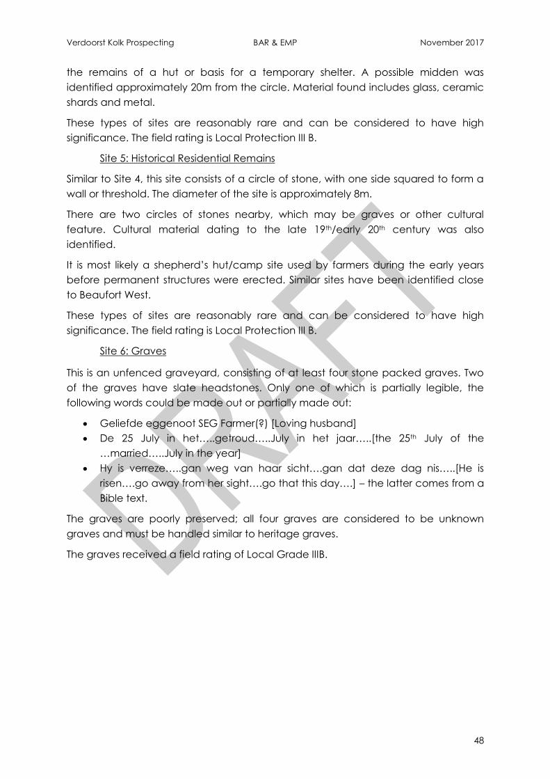
Verdoorst Kolk Prospecting BAR & EMP November 2017
48
the remains of a hut or basis for a temporary shelter. A possible midden was
identified approximately 20m from the circle. Material found includes glass, ceramic
shards and metal.
These types of sites are reasonably rare and can be considered to have high
significance. The field rating is Local Protection III B.
Site 5: Historical Residential Remains
Similar to Site 4, this site consists of a circle of stone, with one side squared to form a
wall or threshold. The diameter of the site is approximately 8m.
There are two circles of stones nearby, which may be graves or other cultural
feature. Cultural material dating to the late 19th/early 20th century was also
identified.
It is most likely a shepherd’s hut/camp site used by farmers during the early years
before permanent structures were erected. Similar sites have been identified close
to Beaufort West.
These types of sites are reasonably rare and can be considered to have high
significance. The field rating is Local Protection III B.
Site 6: Graves
This is an unfenced graveyard, consisting of at least four stone packed graves. Two
of the graves have slate headstones. Only one of which is partially legible, the
following words could be made out or partially made out:
Geliefde eggenoot SEG Farmer(?) [Loving husband]
De 25 July in het…..getroud…..July in het jaar…..[the 25th July of the
…married…..July in the year]
Hy is verreze…..gan weg van haar sicht….gan dat deze dag nis…..[He is
risen….go away from her sight….go that this day….] – the latter comes from a
Bible text.
The graves are poorly preserved; all four graves are considered to be unknown
graves and must be handled similar to heritage graves.
The graves received a field rating of Local Grade IIIB.
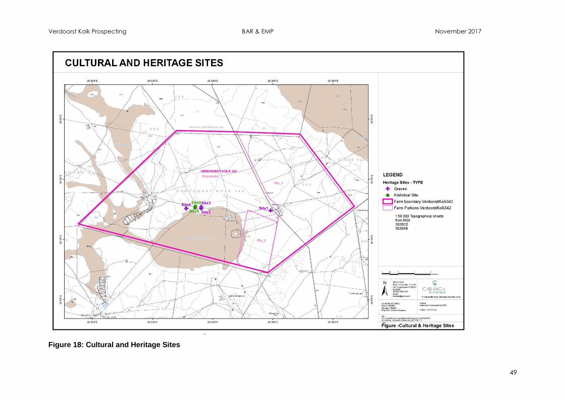
Verdoorst Kolk Prospecting BAR & EMP November 2017
49
Figure 18: Cultural and Heritage Sites
Verdoorst Kolk Prospecting BAR & EMP November 2017
50
11.1.11 Palaeontological Setting (Bamford, 2017)
A desktop Paleontological Impact Assessment was completed by Prof. M.Bramford,
attached as Appendix H. The findings of which are summarised below.
Diamictites and tillites of the Dwyka Formation represent the retreating glaciers of
the Late Carboniferous and do not commonly preserve fossils but there have been
reports of vascular plants, trace fossils, organic-walled, microfossils, rare marine
invertebrates and fish from the Douglas area far to the east (McLachlan and
Anderson, 1973). From the Whitehill Formation Mesosaurus, an early reptile, has only
been reported from Namibia, north of Kimberley and near Calvinia (McLachlan and
Anderson, 1973; Oelofsen and Araujo, 1987). Whitehill Formation plants are also very
rare. The Kalahari Group sediments could preserve Cenozoic fossils but most of it is
aeolian, however, there are some pans and springs that trap and preserve fossils, for
example Kathu Pan. None has been reported from this area.
The proposed prospecting area is on mudrocks of the Prince Albert Formation which
represents suspension settling of muds and turbidites in a marine or deltaic
environment. Deltaic deposits with phosphatic and siliceous concentrations are
probably the result of chemical or biological processes occurring in a reducing
environment (Johnson et al. 2006). Fossils have not been reported from the Prince
Albert Formation in this area, and they are extremely rare in this formation elsewhere.
Such settings are not good for the preservation of fossils. Dolerite dykes are also
present in the proposed area and they would have destroyed any fossils that might
have present in their near vicinity.
According to the SAHRIS palaeosensitivity map there is very little chance of finding
fossils in this area. A survey of the geological formations and literature confirms this.
11.1.12 Socio-economic
The information below is largely extracted from http://www.hantam.gov.za/ and
http://www.statssa.gov.za/?page_id=993&id=hantam-municipality.
The proposed prospecting area falls within the Hantam Local Municipality of the
Namaqwa District Municipality. The Hantam Municipality covers approximately
36,128km² and includes Calvinia (the centre) as well as Brandvlei, Loeriesfontein,
Middelpos and Nieuwoudtville. Farming is the main contributor to the economy,
namely sheep, wool, lucerne as well as rooibos tea.
According to Census 2011, Hantam Municipality has a total population of 21 578,
with a growth rate of 0.59% (2001-2011). Approximately 82.2% of the population are
coloured, 12.1% are white, 4.4% are black African, and 0.7% consists of Indian/Asian.
The remainder of the population (0.6%) is made up by other groups. The
predominant spoken language is Afrikaans, followed by English and isiXhosa.
Of those aged 20 years and older, 18.8% completed Grade 12, 19.7% have some
primary education, 8,4% completed primary education, 30,6% completed some

Verdoorst Kolk Prospecting BAR & EMP November 2017
51
secondary education, 8,1% have some higher education and only 14,4% had no
schooling. The unemployment rate for the Municipality is 11,8%.
There are 6 340 households in the municipality, with an average household size of 3.2
persons per household. Of the households, 59.8% have access to piped (tap) water
inside the dwelling/institution, 35.9% have access to piped (tap) water inside the
yard and 76.9% have access to electricity for lighting.
11.2 Description of the Current Land Use.
Land use within the study area is limited to grazing, this is mainly as a result of the
shallow soil depth, erratic rainfall and high temperatures in summer. Agricultural
potential is low within the study area. Grazing Capacity is set at one (1) large stock
unit per 50 hectares and one (1) small stock unit per 10 Hectares. Supplementation
of feed is necessary to sustain livestock within the area.
Historical salt farming was practiced onsite. Two small, old salt works were noted
within the pan’s footprint. These have been abandoned for approximately 10 and
30 years.
Other infrastructure on site includes farmsteads, roads and farm dams.
11.3 Description of Specific Environmental Features and Infrastructure on the site.
The project area has been assessed for biodiversity importance at a local, district
and provincial scales in the past decade. The plans have mapped areas within the
region that have biodiversity importance and must be managed accordingly. These
areas have been mapped from a combination of spatial layers resulting in
importance as well as from expert opinion and include Critical Biodiversity Areas
(CBA’s) and Ecological Support Areas (ESA’s). These areas must be protected to
safeguard their role in maintaining critical ecosystem services.
The Northern Cape Critical Biodiversity Areas was published in 2016 by the Northern
Cape Department of Environment and Nature Conservation, which updates and
replaces all older systematic biodiversity plans and associated products for the
province, such as the Namakwa District Biodiversity Sector Plan (NDBSP, 2008) and
the Cape Fine Scale Biodiversity Planning project (Ralston et al., 2009).
The vloere / salt pan and drainage areas (the wetlands) present in the study area
was identified as a type 2 Critical Biodiversity Area (CBA2) by expert opinion in the
terrestrial assessment (NDBSP, 2008). This area has subsequently been upgraded to
CBA1 in the updated Northern Cape plan. Furthermore, much of the surrounding
vegetation is mapped as CBA 2 (Figure 19).
The pan is not an aquatic CBA/ESA due to its extreme ephemeral state; despite
being a wetland ecosystem.
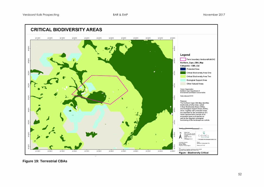
Verdoorst Kolk Prospecting BAR & EMP November 2017
52
Figure 19: Terrestrial CBAs
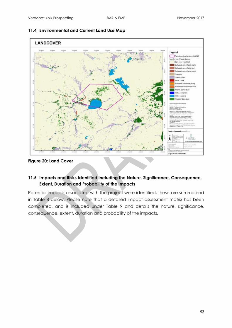
Verdoorst Kolk Prospecting BAR & EMP November 2017
53
11.4 Environmental and Current Land Use Map
Figure 20: Land Cover
11.5 Impacts and Risks Identified including the Nature, Significance, Consequence,
Extent, Duration and Probability of the Impacts
Potential impacts associated with the project were identified, these are summarised
in Table 8 below. Please note that a detailed impact assessment matrix has been
completed, and is included under Table 9 and details the nature, significance,
consequence, extent, duration and probability of the impacts.
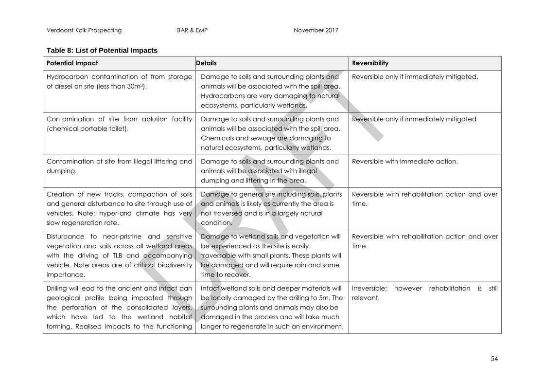
Verdoorst Kolk Prospecting BAR & EMP November 2017
54
Table 8: List of Potential Impacts
Potential Impact Details Reversibility
Hydrocarbon contamination of from storage
of diesel on site (less than 30m3).
Damage to soils and surrounding plants and
animals will be associated with the spill area.
Hydrocarbons are very damaging to natural
ecosystems, particularly wetlands.
Reversible only if immediately mitigated.
Contamination of site from ablution facility
(chemical portable toilet).
Damage to soils and surrounding plants and
animals will be associated with the spill area.
Chemicals and sewage are damaging to
natural ecosystems, particularly wetlands.
Reversible only if immediately mitigated
Contamination of site from illegal littering and
dumping.
Damage to soils and surrounding plants and
animals will be associated with illegal
dumping and littering in the area.
Reversible with immediate action.
Creation of new tracks, compaction of soils
and general disturbance to site through use of
vehicles. Note: hyper-arid climate has very
slow regeneration rate.
Damage to general site including soils, plants
and animals is likely as currently the area is
not traversed and is in a largely natural
condition.
Reversible with rehabilitation action and over
time.
Disturbance to near-pristine and sensitive
vegetation and soils across all wetland areas
with the driving of TLB and accompanying
vehicle. Note areas are of critical biodiversity
importance.
Damage to wetland soils and vegetation will
be experienced as the site is easily
traversable with small plants. These plants will
be damaged and will require rain and some
time to recover.
Reversible with rehabilitation action and over
time.
Drilling will lead to the ancient and intact pan
geological profile being impacted through
the perforation of the consolidated layers,
which have led to the wetland habitat
forming. Realised impacts to the functioning
Intact wetland soils and deeper materials will
be locally damaged by the drilling to 5m. The
surrounding plants and animals may also be
damaged in the process and will take much
longer to regenerate in such an environment.
Irreversible; however rehabilitation is still
relevant.

Verdoorst Kolk Prospecting BAR & EMP November 2017
55
Potential Impact Details Reversibility
of the hydropedological system are uncertain;
but may result in localised dewatering of rain
water as intact impermeable layers are
disturbed.
Damage to vegetation and possibly
zooplankton egg banks. Natural restoration
rate is extremely slow in this system. Note
areas are of critical biodiversity importance.
Damage to wetland soils and vegetation will
be experienced as the site is easily
traversable with small plants. These plants will
be damaged and will require rain and some
time to recover.
Reversible with rehabilitation action and over
time.
Introduction and establishment of alien
invasive plant species
Alien and invasive plants are extremely
damaging to the natural functioning of
ecosystems.
Reversible with immediate and follow-up
rehabilitation action.
Loss or displacement of faunal species of
conservation concern.
Damage to the fauna of the area is possible
including birds, lizzards, insects and the
zooplankton in the soils.
May be reversible with immediate and follow-
up rehabilitation action.
Six sites were identified with high cultural
significance. Whilst no sites will be directly
impacted on by the proposed borehole
locations, secondary impacts to these areas
may occur if unmanaged (i.e. as a result of
dust etc.).
Damage to heritage sites should not be
experienced if mitigation measures are
followed.
Reversible with immediate and follow-up
rehabilitation action.
Generation of nuisance dust from drilling
operations.
Inconvenience to neighbours as a result of
nuisance dust liberated by vehicle
movement and drilling activities on site.
Reversible.
Nuisance noise generated by the operators
and drill rig on site.
Inconvenience to neighbours and possible
disturbance of fauna due to noise from
Reversible.
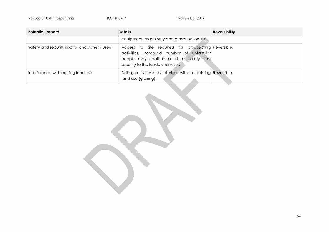
Verdoorst Kolk Prospecting BAR & EMP November 2017
56
Potential Impact Details Reversibility
equipment, machinery and personnel on site.
Safety and security risks to landowner / users Access to site required for prospecting
activities. Increased number of unfamiliar
people may result in a risk of safety and
security to the landowner/user.
Reversible.
Interference with existing land use. Drilling activities may interfere with the existing
land use (grazing).
Reversible.
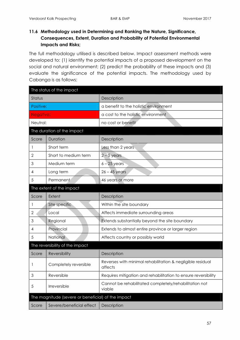
Verdoorst Kolk Prospecting BAR & EMP November 2017
57
11.6 Methodology used in Determining and Ranking the Nature, Significance,
Consequences, Extent, Duration and Probability of Potential Environmental
Impacts and Risks;
The full methodology utilised is described below. Impact assessment methods were
developed to: (1) identify the potential impacts of a proposed development on the
social and natural environment; (2) predict the probability of these impacts and (3)
evaluate the significance of the potential impacts. The methodology used by
Cabanga is as follows:
The status of the impact
Status Description
Positive: a benefit to the holistic environment
Negative: a cost to the holistic environment
Neutral: no cost or benefit
The duration of the impact
Score Duration Description
1 Short term Less than 2 years
2 Short to medium term 2 – 5 years
3 Medium term 6 – 25 years
4 Long term 26 – 45 years
5 Permanent 46 years or more
The extent of the impact
Score Extent Description
1 Site specific Within the site boundary
2 Local Affects immediate surrounding areas
3 Regional Extends substantially beyond the site boundary
4 Provincial Extends to almost entire province or larger region
5 National Affects country or possibly world
The reversibility of the impact
Score Reversibility Description
1 Completely reversible Reverses with minimal rehabilitation & negligible residual
affects
3 Reversible Requires mitigation and rehabilitation to ensure reversibility
5 Irreversible Cannot be rehabilitated completely/rehabilitation not
viable
The magnitude (severe or beneficial) of the impact
Score Severe/beneficial effect Description
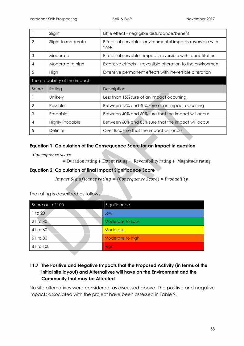
Verdoorst Kolk Prospecting BAR & EMP November 2017
58
1 Slight Little effect - negligible disturbance/benefit
2 Slight to moderate Effects observable - environmental impacts reversible with
time
3 Moderate Effects observable - impacts reversible with rehabilitation
4 Moderate to high Extensive effects - irreversible alteration to the environment
5 High Extensive permanent effects with irreversible alteration
The probability of the impact
Score Rating Description
1 Unlikely Less than 15% sure of an impact occurring
2 Possible Between 15% and 40% sure of an impact occurring
3 Probable Between 40% and 60% sure that the impact will occur
4 Highly Probable Between 60% and 85% sure that the impact will occur
5 Definite Over 85% sure that the impact will occur
Equation 1: Calculation of the Consequence Score for an impact in question
Equation 2: Calculation of final Impact Significance Score
The rating is described as follows:
Score out of 100 Significance
1 to 20 Low
21 to 40 Moderate to Low
41 to 60 Moderate
61 to 80 Moderate to high
81 to 100 High
11.7 The Positive and Negative Impacts that the Proposed Activity (in terms of the
initial site layout) and Alternatives will have on the Environment and the
Community that may be Affected
No site alternatives were considered, as discussed above. The positive and negative
impacts associated with the project have been assessed in Table 9.
Verdoorst Kolk Prospecting BAR & EMP November 2017
59
11.8 The Possible Mitigation Measures that could be Applied and the Level of Risk
No issues and concerns have been raised as of yet by Interested and Affected
Parties.
11.9 Motivation where No Alternative Sites were Considered
With regard to location, the prospecting activities are delimited by the properties
available for prospecting (i.e. not held by another company) and the geology of
the area. The preliminary positions of the proposed prospecting boreholes have
been sited to give a representative sample for the area of interest.
11.10 Statement Motivating the Alternative Development Location within the Overall
Site
As mentioned earlier, Gypsum typically forms in the upper region of the weathering
profile in salt pans and in shales of the Ecca Group of the Karoo Supergroup. This
typically occurs in areas where evaporation rates are high and precipitation rates
are low. Thus, the Verdoorst Kolk pan forms the focus area of the prospecting
programme as this is where the mineral is most likely to be concentrated.
11.11 Full Description of the Process Undertaken to Identify, Assess and Rank the
Impacts and Risks the Activity will Impose on the Preferred Site (In respect of
the final site layout plan) through the life of the activity.
Physical, biological and social/cultural impacts were assessed for the proposed
project. The steps undertaken to assess these impacts included:
Project screening and desktop investigations;
Site surveys and specialist input;
Public Participation; and
The assessment and compilation of information by the EAP project team.
Impact identification has therefore been a consolidated approach based on
Cabanga's professional experience and specialist input.
Table 9 below details the impact assessment matrix for the project.
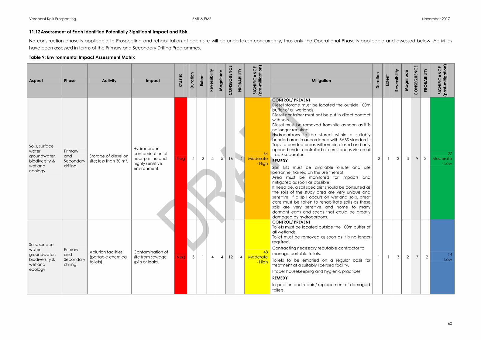
Verdoorst Kolk Prospecting BAR & EMP November 2017
60
11.12 Assessment of Each Identified Potentially Significant Impact and Risk
No construction phase is applicable to Prospecting and rehabilitation of each site will be undertaken concurrently, thus only the Operational Phase is applicable and assessed below. Activities
have been assessed in terms of the Primary and Secondary Drilling Programmes.
Table 9: Environmental Impact Assessment Matrix
Aspect Phase Activity Impact
STA
TUS
Du
ratio
n
Ex
ten
t
Re
ve
rsib
ility
Ma
gn
itu
de
CO
NSEQ
UEN
CE
PR
OB
AB
ILIT
Y
SIG
NIF
ICA
NC
E
(pre
-mitig
atio
n)
Mitigation
Du
ratio
n
Ex
ten
t
Re
ve
rsib
ility
Ma
gn
itu
de
CO
NSEQ
UEN
CE
PR
OB
AB
ILIT
Y
SIG
NIF
ICA
NC
E
(po
st-m
itig
atio
n)
Soils, surface
water,
groundwater,
biodiversity &
wetland
ecology
Primary
and
Secondary
drilling
Storage of diesel on
site; less than 30 m3.
Hydrocarbon
contamination of
near-pristine and
highly sensitive
environment.
Neg 4 2 5 5 16 4
64
Moderate
- High
CONTROL/ PREVENT
Diesel storage must be located the outside 100m
buffer of all wetlands.
Diesel container must not be put in direct contact
with soils.
Diesel must be removed from site as soon as it is
no longer required.
Hydrocarbons to be stored within a suitably
bunded area in accordance with SABS standards.
Taps to bunded areas will remain closed and only
opened under controlled circumstances via an oil
trap / separator.
REMEDY
Spill kits must be available onsite and site
personnel trained on the use thereof.
Area must be monitored for impacts and
mitigated as soon as possible.
If need be, a soil specialist should be consulted as
the soils of the study area are very unique and
sensitive. If a spill occurs on wetland soils, great
care must be taken to rehabilitate spills as these
soils are very sensitive and home to many
dormant eggs and seeds that could be greatly
damaged by hydrocarbons.
2 1 3 3 9 3
27
Moderate
- Low
Soils, surface
water,
groundwater,
biodiversity &
wetland
ecology
Primary
and
Secondary
drilling
Ablution facilities
(portable chemical
toilets).
Contamination of
site from sewage
spills or leaks.
Neg 3 1 4 4 12 4
48
Moderate
- High
CONTROL/ PREVENT
Toilets must be located outside the 100m buffer of
all wetlands.
Toilet must be removed as soon as it is no longer
required.
Contracting necessary reputable contractor to
manage portable toilets.
Toilets to be emptied on a regular basis for
treatment at a suitably licensed facility.
Proper housekeeping and hygienic practices.
REMEDY
Inspection and repair / replacement of damaged
toilets.
1 1 3 2 7 2 14
Low

Verdoorst Kolk Prospecting BAR & EMP November 2017
61
Aspect Phase Activity Impact
STA
TUS
Du
ratio
n
Ex
ten
t
Re
ve
rsib
ility
Ma
gn
itu
de
CO
NSEQ
UEN
CE
PR
OB
AB
ILIT
Y
SIG
NIF
ICA
NC
E
(pre
-mitig
atio
n)
Mitigation
Du
ratio
n
Ex
ten
t
Re
ve
rsib
ility
Ma
gn
itu
de
CO
NSEQ
UEN
CE
PR
OB
AB
ILIT
Y
SIG
NIF
ICA
NC
E
(po
st-m
itig
atio
n)
Soils, surface
water,
groundwater,
biodiversity &
wetland
ecology
Primary
and
Secondary
drilling
Waste generation
Contamination of
site as a result of
illegal
littering/dumping
Neg 2 1 3 2 8 3
24
Moderate
-Low
CONTROL/ PREVENT
Environmental awareness training to be provided
to all site personnel.
Bins to be provided on site.
Inspection and immediate action.
Proper housekeeping and hygienic practices.
REMEDY
Clearing all litter and waste.
1 1 3 2 7 2 14
Low
Soils, surface
water,
groundwater,
biodiversity &
wetland
ecology
Primary
and
Secondary
drilling
Driving of TLB and
Bakkie around site
on existing farm
roads but also over
vegetation.
Creation of new
tracks, compaction
of soils and general
disturbance to site.
Note: hyper-arid
climate has very
slow regeneration
rate.
Neg 4 2 3 3 12 4 48
Moderate
CONTROL/ PREVENT
Existing farms roads must be used as far as
possible to minimize impact.
Activity must be planned to minimize the tracks
created across the site.
All vehicles must follow the same tracks.
REMEDY
Rehabilitation of the tracks may be necessary if
compaction occurs. A soil specialist should be
consulted as the soils of the study area are very
unique and sensitive. Monitoring of site to assess
rehabilitation success should be done with repeat
photography included in the monitoring.
3 1 3 2 9 3
27
Moderate
- Low
Wetland
Ecology
Primary
drilling
Driving of TLB and
accompanying
vehicle within and
around wetlands
including the salt
pan, drainage
wetlands and their
buffer areas.
Disturbance to
near-pristine and
sensitive
vegetation and
soils across all
wetland areas and
their buffer areas.
Note areas are of
critical biodiversity
importance.
Neg 3 1 2 3 9 5 45
Moderate
CONTROL/ PREVENT
Detailed plan of route for driving between sample
areas must be done and ensure activity is
maintained within these areas to keep affected
area as small as possible.
Botanist must do detailed walk of proposed routes
to check for species of conservation concern,
which must first be relocated.
Wetland specialist and/or EO must be present to
monitor activity and ensure minimal
environmental damage.
REMEDY
All disturbed areas may need to be rehabilitated
after vehicle traversing is complete.
3 1 2 2 8 4
32
Moderate
- Low
Wetland
Ecology
Primary
drilling
Clearing of
vegetation and
drilling of 50 auger
holes to max 5 m
depth. Activity
includes immediate
backfilling and
rehabilitation of
impact footprint.
Drilling will lead to
the ancient and
intact pan
geological profile
being impacted
through the
perforation of the
consolidated
layers, which have
led to the wetland
habitat forming.
Realised impacts to
Neg 4 1 2 3 10 5 50
Moderate
CONTROL/ PREVENT
Properly demarcate areas for auger drilling and
ensure activity is maintained within the
demarcations to keep affected area as small as
possible.
Wetland specialist and/or EO must be present to
monitor activity and ensure minimal
environmental damage.
Vegetation removal must be over as small an
area as possible.
Plastic sheeting can be placed around expected
auger hole and soil displacement area to prevent
3 1 2 2 8 5
40
Moderate
- Low
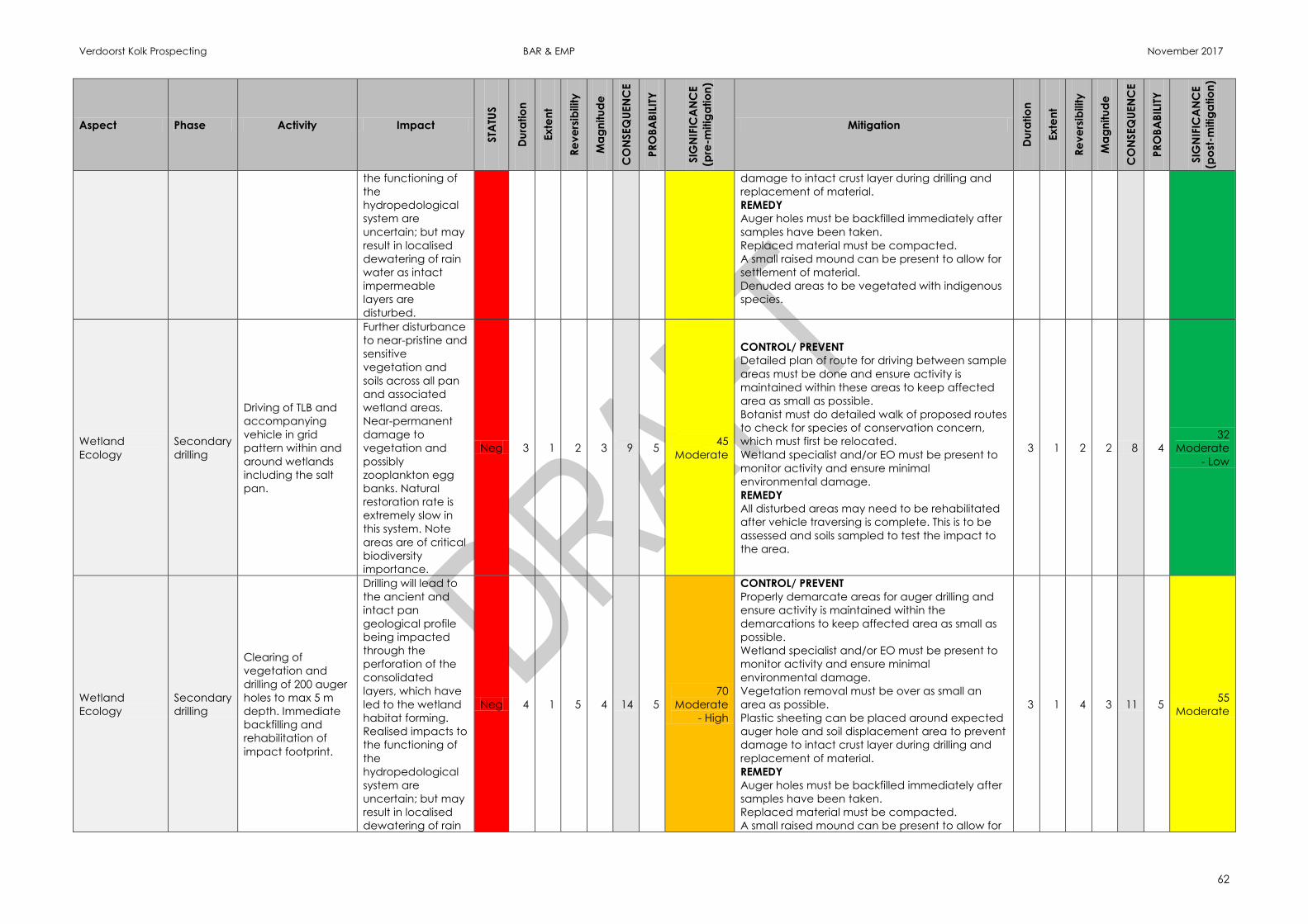
Verdoorst Kolk Prospecting BAR & EMP November 2017
62
Aspect Phase Activity Impact
STA
TUS
Du
ratio
n
Ex
ten
t
Re
ve
rsib
ility
Ma
gn
itu
de
CO
NSEQ
UEN
CE
PR
OB
AB
ILIT
Y
SIG
NIF
ICA
NC
E
(pre
-mitig
atio
n)
Mitigation
Du
ratio
n
Ex
ten
t
Re
ve
rsib
ility
Ma
gn
itu
de
CO
NSEQ
UEN
CE
PR
OB
AB
ILIT
Y
SIG
NIF
ICA
NC
E
(po
st-m
itig
atio
n)
the functioning of
the
hydropedological
system are
uncertain; but may
result in localised
dewatering of rain
water as intact
impermeable
layers are
disturbed.
damage to intact crust layer during drilling and
replacement of material.
REMEDY
Auger holes must be backfilled immediately after
samples have been taken.
Replaced material must be compacted.
A small raised mound can be present to allow for
settlement of material.
Denuded areas to be vegetated with indigenous
species.
Wetland
Ecology
Secondary
drilling
Driving of TLB and
accompanying
vehicle in grid
pattern within and
around wetlands
including the salt
pan.
Further disturbance
to near-pristine and
sensitive
vegetation and
soils across all pan
and associated
wetland areas.
Near-permanent
damage to
vegetation and
possibly
zooplankton egg
banks. Natural
restoration rate is
extremely slow in
this system. Note
areas are of critical
biodiversity
importance.
Neg 3 1 2 3 9 5 45
Moderate
CONTROL/ PREVENT
Detailed plan of route for driving between sample
areas must be done and ensure activity is
maintained within these areas to keep affected
area as small as possible.
Botanist must do detailed walk of proposed routes
to check for species of conservation concern,
which must first be relocated.
Wetland specialist and/or EO must be present to
monitor activity and ensure minimal
environmental damage.
REMEDY
All disturbed areas may need to be rehabilitated
after vehicle traversing is complete. This is to be
assessed and soils sampled to test the impact to
the area.
3 1 2 2 8 4
32
Moderate
- Low
Wetland
Ecology
Secondary
drilling
Clearing of
vegetation and
drilling of 200 auger
holes to max 5 m
depth. Immediate
backfilling and
rehabilitation of
impact footprint.
Drilling will lead to
the ancient and
intact pan
geological profile
being impacted
through the
perforation of the
consolidated
layers, which have
led to the wetland
habitat forming.
Realised impacts to
the functioning of
the
hydropedological
system are
uncertain; but may
result in localised
dewatering of rain
Neg 4 1 5 4 14 5
70
Moderate
- High
CONTROL/ PREVENT
Properly demarcate areas for auger drilling and
ensure activity is maintained within the
demarcations to keep affected area as small as
possible.
Wetland specialist and/or EO must be present to
monitor activity and ensure minimal
environmental damage.
Vegetation removal must be over as small an
area as possible.
Plastic sheeting can be placed around expected
auger hole and soil displacement area to prevent
damage to intact crust layer during drilling and
replacement of material.
REMEDY
Auger holes must be backfilled immediately after
samples have been taken.
Replaced material must be compacted.
A small raised mound can be present to allow for
3 1 4 3 11 5 55
Moderate
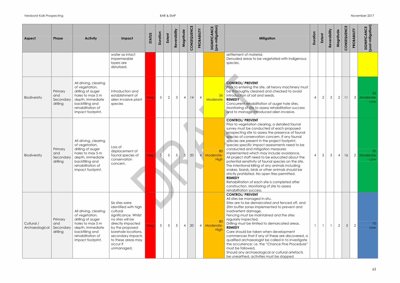
Verdoorst Kolk Prospecting BAR & EMP November 2017
63
Aspect Phase Activity Impact
STA
TUS
Du
ratio
n
Ex
ten
t
Re
ve
rsib
ility
Ma
gn
itu
de
CO
NSEQ
UEN
CE
PR
OB
AB
ILIT
Y
SIG
NIF
ICA
NC
E
(pre
-mitig
atio
n)
Mitigation
Du
ratio
n
Ex
ten
t
Re
ve
rsib
ility
Ma
gn
itu
de
CO
NSEQ
UEN
CE
PR
OB
AB
ILIT
Y
SIG
NIF
ICA
NC
E
(po
st-m
itig
atio
n)
water as intact
impermeable
layers are
disturbed.
settlement of material.
Denuded areas to be vegetated with indigenous
species.
Biodiversity
Primary
and
Secondary
drilling
All driving, clearing
of vegetation,
drilling of auger
holes to max 5 m
depth, immediate
backfilling and
rehabilitation of
impact footprint.
Introduction and
establishment of
alien invasive plant
species
Neg 5 2 3 4 14 4 56
Moderate
CONTROL/ PREVENT
Prior to entering the site, all heavy machinery must
be thoroughly cleaned and checked to avoid
introduction of soil and seeds.
REMEDY
Concurrent rehabilitation of auger hole sites.
Monitoring of site to assess rehabilitation success
and to manage introduced alien invasive.
4 2 3 2 11 3
33
Moderate
- Low
Biodiversity
Primary
and
Secondary
drilling
All driving, clearing
of vegetation,
drilling of auger
holes to max 5 m
depth, immediate
backfilling and
rehabilitation of
impact footprint.
Loss of
displacement of
faunal species of
conservation
concern.
Neg 5 5 5 5 20 4
80
Moderate-
High
CONTROL/ PREVENT
Prior to vegetation clearing, a detailed faunal
survey must be conducted of each proposed
prospecting site to assess the presence of faunal
species of conservation concern. If any faunal
species are present in the project footprint,
species specific impact assessments need to be
conducted and mitigation measures
implemented which may include avoidance.
All project staff need to be educated about the
potential sensitivity of faunal species on the site.
The intentional killing of any animals including
snakes, lizards, birds or other animals should be
strictly prohibited. No open fires permitted.
REMEDY
Rehabilitation of each site is completed after
construction. Monitoring of site to assess
rehabilitation success.
4 5 3 4 16 2
32
Moderate
- Low
Cultural /
Archaeological
Primary
and
Secondary
drilling
All driving, clearing
of vegetation,
drilling of auger
holes to max 5 m
depth, immediate
backfilling and
rehabilitation of
impact footprint.
Six sites were
identified with high
cultural
significance. Whilst
no sites will be
directly impacted
by the proposed
borehole locations,
secondary impacts
to these areas may
occur if
unmanaged.
Neg 5 5 5 4 20 4
80
Moderate-
High
CONTROL/ PREVENT
All sites be managed in-situ.
Sites are to be demarcated and fenced off, and
20m buffer zones implemented to prevent and
inadvertent damage.
Fencing must be maintained and the sites
regularly inspected.
Drilling must be limited to demarcated areas.
REMEDY
Care should be taken when development
commences that if any of these are discovered, a
qualified archaeologist be called in to investigate
the occurrence; i.e. the “Chance Fine Procedure”
must be followed.
Should any archaeological or cultural artefacts
be unearthed, activities must be stopped
1 1 1 2 5 2 10
Low
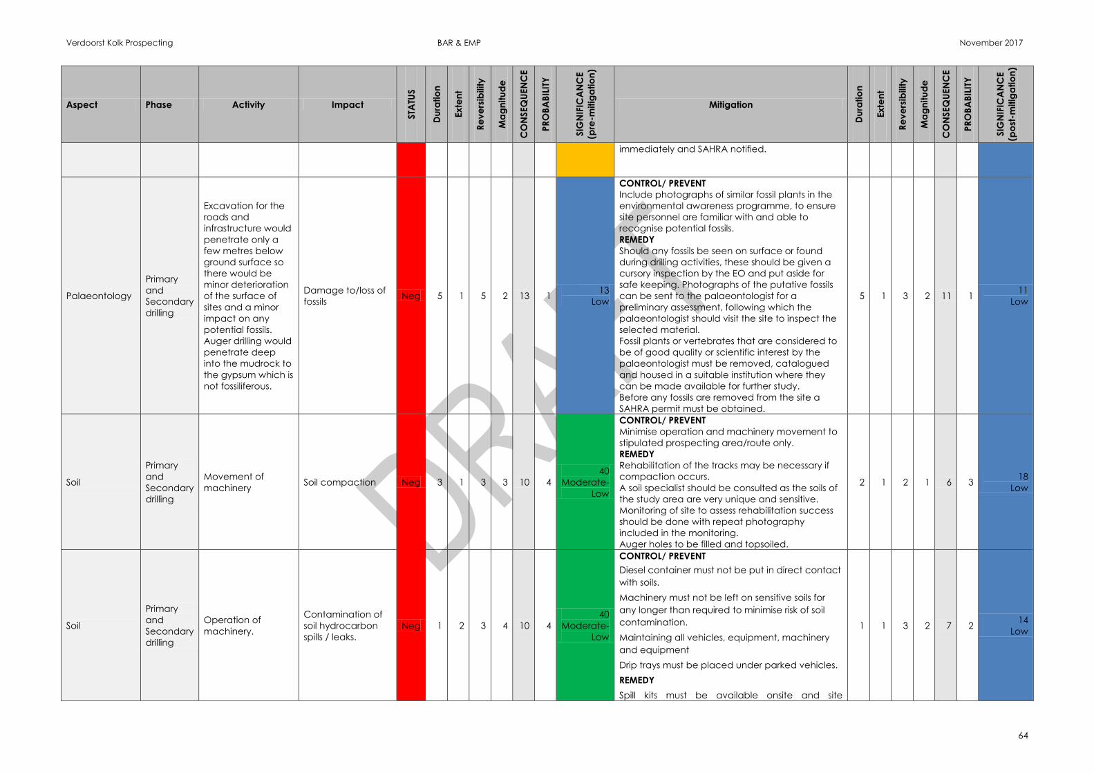
Verdoorst Kolk Prospecting BAR & EMP November 2017
64
Aspect Phase Activity Impact
STA
TUS
Du
ratio
n
Ex
ten
t
Re
ve
rsib
ility
Ma
gn
itu
de
CO
NSEQ
UEN
CE
PR
OB
AB
ILIT
Y
SIG
NIF
ICA
NC
E
(pre
-mitig
atio
n)
Mitigation
Du
ratio
n
Ex
ten
t
Re
ve
rsib
ility
Ma
gn
itu
de
CO
NSEQ
UEN
CE
PR
OB
AB
ILIT
Y
SIG
NIF
ICA
NC
E
(po
st-m
itig
atio
n)
immediately and SAHRA notified.
Palaeontology
Primary
and
Secondary
drilling
Excavation for the
roads and
infrastructure would
penetrate only a
few metres below
ground surface so
there would be
minor deterioration
of the surface of
sites and a minor
impact on any
potential fossils.
Auger drilling would
penetrate deep
into the mudrock to
the gypsum which is
not fossiliferous.
Damage to/loss of
fossils Neg 5 1 5 2 13 1
13
Low
CONTROL/ PREVENT
Include photographs of similar fossil plants in the
environmental awareness programme, to ensure
site personnel are familiar with and able to
recognise potential fossils.
REMEDY
Should any fossils be seen on surface or found
during drilling activities, these should be given a
cursory inspection by the EO and put aside for
safe keeping. Photographs of the putative fossils
can be sent to the palaeontologist for a
preliminary assessment, following which the
palaeontologist should visit the site to inspect the
selected material.
Fossil plants or vertebrates that are considered to
be of good quality or scientific interest by the
palaeontologist must be removed, catalogued
and housed in a suitable institution where they
can be made available for further study.
Before any fossils are removed from the site a
SAHRA permit must be obtained.
5 1 3 2 11 1 11
Low
Soil
Primary
and
Secondary
drilling
Movement of
machinery Soil compaction Neg 3 1 3 3 10 4
40
Moderate-
Low
CONTROL/ PREVENT
Minimise operation and machinery movement to
stipulated prospecting area/route only.
REMEDY
Rehabilitation of the tracks may be necessary if
compaction occurs.
A soil specialist should be consulted as the soils of
the study area are very unique and sensitive.
Monitoring of site to assess rehabilitation success
should be done with repeat photography
included in the monitoring.
Auger holes to be filled and topsoiled.
2 1 2 1 6 3 18
Low
Soil
Primary
and
Secondary
drilling
Operation of
machinery.
Contamination of
soil hydrocarbon
spills / leaks.
Neg 1 2 3 4 10 4
40
Moderate-
Low
CONTROL/ PREVENT
Diesel container must not be put in direct contact
with soils.
Machinery must not be left on sensitive soils for
any longer than required to minimise risk of soil
contamination.
Maintaining all vehicles, equipment, machinery
and equipment
Drip trays must be placed under parked vehicles.
REMEDY
Spill kits must be available onsite and site
1 1 3 2 7 2 14
Low
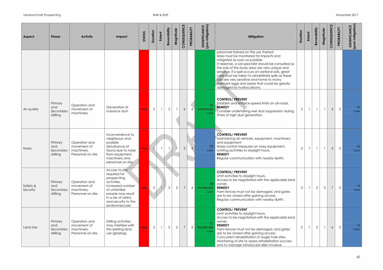
Verdoorst Kolk Prospecting BAR & EMP November 2017
65
Aspect Phase Activity Impact
STA
TUS
Du
ratio
n
Ex
ten
t
Re
ve
rsib
ility
Ma
gn
itu
de
CO
NSEQ
UEN
CE
PR
OB
AB
ILIT
Y
SIG
NIF
ICA
NC
E
(pre
-mitig
atio
n)
Mitigation
Du
ratio
n
Ex
ten
t
Re
ve
rsib
ility
Ma
gn
itu
de
CO
NSEQ
UEN
CE
PR
OB
AB
ILIT
Y
SIG
NIF
ICA
NC
E
(po
st-m
itig
atio
n)
personnel trained on the use thereof.
Area must be monitored for impacts and
mitigated as soon as possible.
If need be, a soil specialist should be consulted as
the soils of the study area are very unique and
sensitive. If a spill occurs on wetland soils, great
care must be taken to rehabilitate spills as these
soils are very sensitive and home to many
dormant eggs and seeds that could be greatly
damaged by hydrocarbons.
Air quality
Primary
and
Secondary
drilling
Operation and
movement of
machinery
Generation of
nuisance dust. Neg 2 1 2 1 6 4
24
Moderate
-Low
CONTROL/ PREVENT
Establish and enforce speed limits on all roads.
REMEDY
Consider undertaking wet dust suppression during
times of high dust generation.
2 1 1 1 5 2 10
Low
Noise
Primary
and
Secondary
drilling
Operation and
movement of
machinery.
Personnel on site.
Inconvenience to
neighbours and
possible
disturbance of
fauna due to noise
from equipment,
machinery and
personnel on site.
Neg 2 1 1 1 5 4 20
Low
CONTROL/ PREVENT
Maintaining all vehicles, equipment, machinery
and equipment
Noise control measures on noisy equipment.
Limiting activities to daylight hours.
REMEDY
Regular communication with nearby I&APs.
2 1 1 1 5 3 15
Low
Safety &
Security
Primary
and
Secondary
drilling
Operation and
movement of
machinery.
Personnel on site.
Access to site
required for
prospecting
activities.
Increased number
of unfamiliar
people may result
in a risk of safety
and security to the
landowner/user.
Neg 2 1 2 2 7 4
28
Moderate
-Low
CONTROL/ PREVENT
Limit activities to daylight hours.
Access to be negotiated with the applicable land
owner.
REMEDY
Farm fences must not be damaged, and gates
are to be closed after gaining access.
Regular communication with nearby I&APs.
2 1 2 2 7 2 14
Low
Land Use
Primary
and
Secondary
drilling
Operation and
movement of
machinery.
Personnel on site.
Drilling activities
may interfere with
the existing land
use (grazing).
Neg 2 1 2 2 7 3
21
Moderate
-Low
CONTROL/ PREVENT
Limit activities to daylight hours.
Access to be negotiated with the applicable land
owner.
REMEDY
Farm fences must not be damaged, and gates
are to be closed after gaining access.
Concurrent rehabilitation of auger hole sites.
Monitoring of site to assess rehabilitation success
and to manage introduced alien invasive.
2 1 2 1 6 2 12
Low

Verdoorst Kolk Prospecting BAR & EMP November 2017
66
Aspect Phase Activity Impact
STA
TUS
Du
ratio
n
Ex
ten
t
Re
ve
rsib
ility
Ma
gn
itu
de
CO
NSEQ
UEN
CE
PR
OB
AB
ILIT
Y
SIG
NIF
ICA
NC
E
(pre
-mitig
atio
n)
Mitigation
Du
ratio
n
Ex
ten
t
Re
ve
rsib
ility
Ma
gn
itu
de
CO
NSEQ
UEN
CE
PR
OB
AB
ILIT
Y
SIG
NIF
ICA
NC
E
(po
st-m
itig
atio
n)
Environmental awareness training to be provided
to all project staff.
No open fires permitted.
Regular communication with landowner.

Verdoorst Kolk Prospecting BAR & EMP November 2017
67
11.13 Summary of Specialist Reports
LIST OF
STUDIES UNDERTAKEN
RECOMMENDATIONS OF SPECIALIST
REPORTS
SPECIALIST
RECOMMENDATIONS THAT
HAVE BEEN INCLUDED IN THE
EIA REPORT
(Mark with an X where
applicable)
REFERENCE TO APPLICABLE
SECTION OF REPORT WHERE
SPECIALIST
RECOMMENDATIONS HAVE
BEEN INCLUDED.
Biodiversity Assessment Prevent the introduction and establishment
of alien invasive species. Prior to any heavy
machinery entering the site it must be
thorougly cleaned and checked to avoid
seed introduction.
Prevent the loss or displacement of faunal
species of conservation concern and
prevent further reduction of faunal
biodiversity.
Rehabilitation of each site after
construction.
Areas that are denuded during
prospecting need to be re-vegetated with
indigenous vegetation to avoid creating
an entry point for alien invasive species.
Compilation of and implementation of an
alien invasive management plan for the
site.
Monitoring of site to assess rehabilitation
success and to manage introduced alien
invasives.
Prior to clearing of each site, a detailed
faunal survey must be conducted of each
X The recommendations have
been included in the
mitigation measures section
of Table 9 .
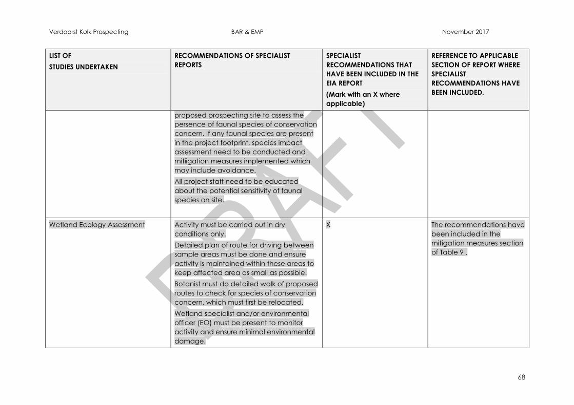
Verdoorst Kolk Prospecting BAR & EMP November 2017
68
LIST OF
STUDIES UNDERTAKEN
RECOMMENDATIONS OF SPECIALIST
REPORTS
SPECIALIST
RECOMMENDATIONS THAT
HAVE BEEN INCLUDED IN THE
EIA REPORT
(Mark with an X where
applicable)
REFERENCE TO APPLICABLE
SECTION OF REPORT WHERE
SPECIALIST
RECOMMENDATIONS HAVE
BEEN INCLUDED.
proposed prospecting site to assess the
persence of faunal species of conservation
concern. If any faunal species are present
in the project footprint, species impact
assessment need to be conducted and
mitiigation measures implemented which
may include avoidance.
All project staff need to be educated
about the potential sensitivity of faunal
species on site.
Wetland Ecology Assessment Activity must be carried out in dry
conditions only.
Detailed plan of route for driving between
sample areas must be done and ensure
activity is maintained within these areas to
keep affected area as small as possible.
Botanist must do detailed walk of proposed
routes to check for species of conservation
concern, which must first be relocated.
Wetland specialist and/or environmental
officer (EO) must be present to monitor
activity and ensure minimal environmental
damage.
X The recommendations have
been included in the
mitigation measures section
of Table 9 .
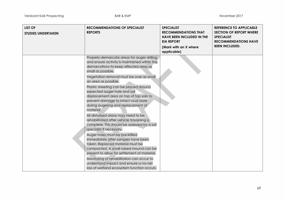
Verdoorst Kolk Prospecting BAR & EMP November 2017
69
LIST OF
STUDIES UNDERTAKEN
RECOMMENDATIONS OF SPECIALIST
REPORTS
SPECIALIST
RECOMMENDATIONS THAT
HAVE BEEN INCLUDED IN THE
EIA REPORT
(Mark with an X where
applicable)
REFERENCE TO APPLICABLE
SECTION OF REPORT WHERE
SPECIALIST
RECOMMENDATIONS HAVE
BEEN INCLUDED.
Properly demarcate areas for auger drilling
and ensure activity is maintained within the
demarcations to keep affected area as
small as possible.
Vegetation removal must be over as small
an area as possible.
Plastic sheeting can be placed around
expected auger hole and soil
displacement area on top of top soils to
prevent damage to intact crust layer
during augering and replacement of
material.
All disturbed areas may need to be
rehabilitated after vehicle traversing is
complete. This should be assessed by a soil
specialist if necessary.
Auger holes must be backfilled
immediately after samples have been
taken. Replaced material must be
compacted. A small raised mound can be
present to allow for settlement of material.
Monitoring of rehabilitation can occur to
understand impact and ensure a no-net
loss of wetland ecosystem function occurs.
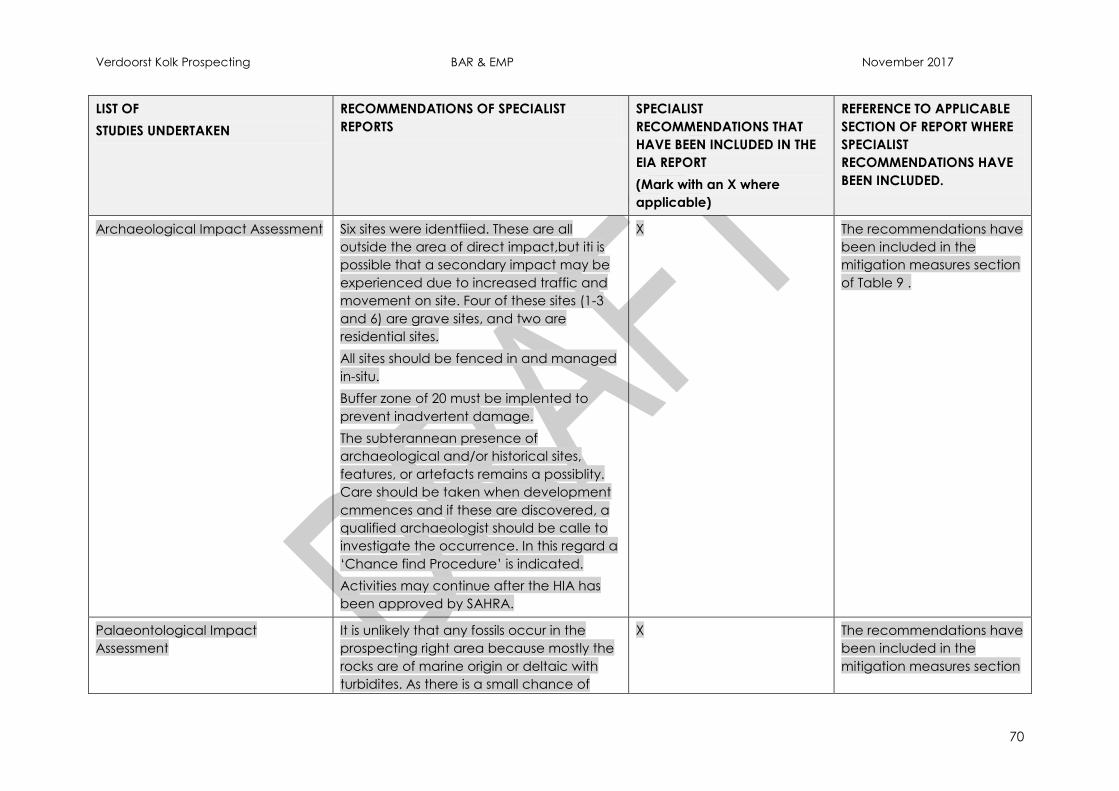
Verdoorst Kolk Prospecting BAR & EMP November 2017
70
LIST OF
STUDIES UNDERTAKEN
RECOMMENDATIONS OF SPECIALIST
REPORTS
SPECIALIST
RECOMMENDATIONS THAT
HAVE BEEN INCLUDED IN THE
EIA REPORT
(Mark with an X where
applicable)
REFERENCE TO APPLICABLE
SECTION OF REPORT WHERE
SPECIALIST
RECOMMENDATIONS HAVE
BEEN INCLUDED.
Archaeological Impact Assessment Six sites were identfiied. These are all
outside the area of direct impact,but iti is
possible that a secondary impact may be
experienced due to increased traffic and
movement on site. Four of these sites (1-3
and 6) are grave sites, and two are
residential sites.
All sites should be fenced in and managed
in-situ.
Buffer zone of 20 must be implented to
prevent inadvertent damage.
The subterannean presence of
archaeological and/or historical sites,
features, or artefacts remains a possiblity.
Care should be taken when development
cmmences and if these are discovered, a
qualified archaeologist should be calle to
investigate the occurrence. In this regard a
‘Chance find Procedure’ is indicated.
Activities may continue after the HIA has
been approved by SAHRA.
X The recommendations have
been included in the
mitigation measures section
of Table 9 .
Palaeontological Impact
Assessment
It is unlikely that any fossils occur in the
prospecting right area because mostly the
rocks are of marine origin or deltaic with
turbidites. As there is a small chance of
X The recommendations have
been included in the
mitigation measures section
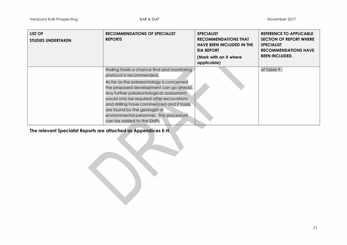
Verdoorst Kolk Prospecting BAR & EMP November 2017
71
LIST OF
STUDIES UNDERTAKEN
RECOMMENDATIONS OF SPECIALIST
REPORTS
SPECIALIST
RECOMMENDATIONS THAT
HAVE BEEN INCLUDED IN THE
EIA REPORT
(Mark with an X where
applicable)
REFERENCE TO APPLICABLE
SECTION OF REPORT WHERE
SPECIALIST
RECOMMENDATIONS HAVE
BEEN INCLUDED.
finding fossils a chance find and monitoring
protocol is recommended.
As far as the palaeontology is concerned
the proposed development can go ahead.
Any further palaeontological assessment
would only be required after excavations
and drilling have commenced and if fossils
are found by the geologist or
environmental personnel. The procedure
can be added to the EMPr.
of Table 9 .
The relevant Specialist Reports are attached as Appendices E-H.
Verdoorst Kolk Prospecting BAR & EMP November 2017
72
11.14 Environmental impact statement
11.14.1 Summary of the key findings of the environmental impact assessment;
An ephemeral depression wetland known as the Verdoorst Kolk pan and a number
of associated drainage wetlands occur within the proposed prospecting area. As
the prospecting programme will include auger drilling, impacts will be realised to the
surrounding environment. These will require mitigation action and active
management.
The environment associated with the Verdoorst Kolk pan is extremely sensitive and,
due to the hyper-arid climatic conditions, natural restoration rates are extremely
slow. A number of cultural and heritage sites were identified within the prospecting
area and these are at risk from secondary impacts. The key impacts to the natural
and cultural environment requiring mitigation and management are:
Compaction of soils;
Damage to sensitive topsoils;
Damage to vegetation and disturbance of fauna, especially species
of conservation concern;
Spread of alien and invasive vegetation post-disturbance;
Damage to seed and egg bank of dormant flora and fauna in top and
subsoils;
Altered local hydrology and geomorphology of intact ancient pan
sediments;
Contamination of soils from hydrocarbon spills and other pollutants;
and
Inadvertent damage to heritage and cultural site.
With proper implementation of the EMP, no post mitigation impacts are expected to
exceed a Significance of Moderate-Low.
11.15 Final Site Map
Provide a map at an appropriate scale which superimposes the proposed overall activity
and its associated structures and infrastructure on the environmental sensitivities of the
preferred site indicating any areas that should be avoided, including buffers.
The final site map indicating the preliminary location of both the Primary and
Secondary drilling programmes is depicted in Figure 21 below.
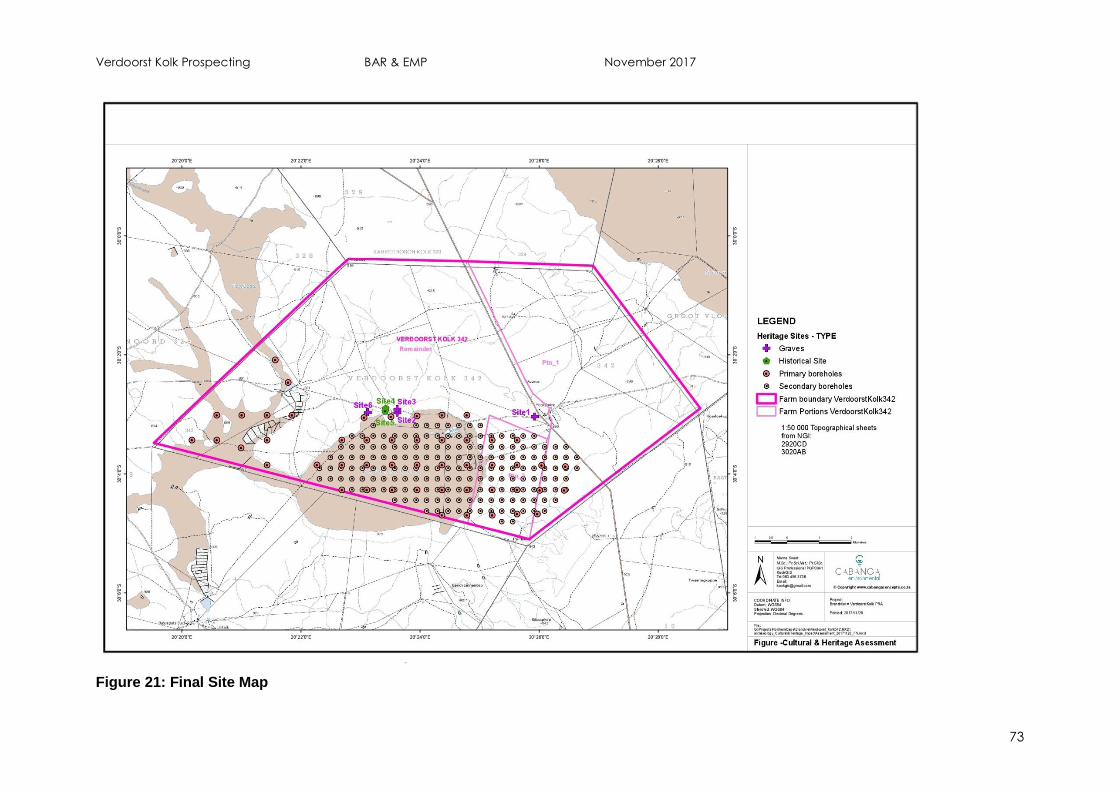
Verdoorst Kolk Prospecting BAR & EMP November 2017
73
Figure 21: Final Site Map
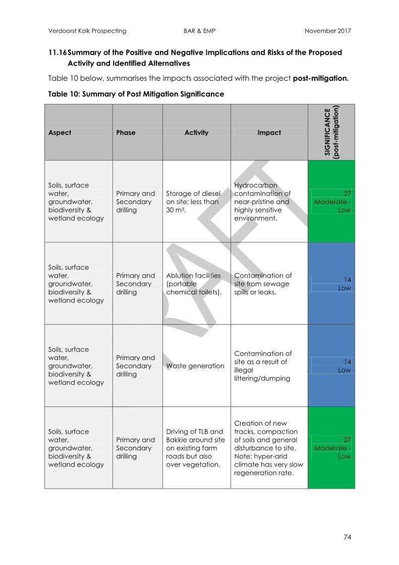
Verdoorst Kolk Prospecting BAR & EMP November 2017
74
11.16 Summary of the Positive and Negative Implications and Risks of the Proposed
Activity and Identified Alternatives
Table 10 below, summarises the impacts associated with the project post-mitigation.
Table 10: Summary of Post Mitigation Significance
Aspect Phase Activity Impact
SIG
NIF
ICA
NC
E
(po
st-m
itig
atio
n)
Soils, surface
water,
groundwater,
biodiversity &
wetland ecology
Primary and
Secondary
drilling
Storage of diesel
on site; less than
30 m3.
Hydrocarbon
contamination of
near-pristine and
highly sensitive
environment.
27
Moderate -
Low
Soils, surface
water,
groundwater,
biodiversity &
wetland ecology
Primary and
Secondary
drilling
Ablution facilities
(portable
chemical toilets).
Contamination of
site from sewage
spills or leaks.
14
Low
Soils, surface
water,
groundwater,
biodiversity &
wetland ecology
Primary and
Secondary
drilling
Waste generation
Contamination of
site as a result of
illegal
littering/dumping
14
Low
Soils, surface
water,
groundwater,
biodiversity &
wetland ecology
Primary and
Secondary
drilling
Driving of TLB and
Bakkie around site
on existing farm
roads but also
over vegetation.
Creation of new
tracks, compaction
of soils and general
disturbance to site.
Note: hyper-arid
climate has very slow
regeneration rate.
27
Moderate -
Low

Verdoorst Kolk Prospecting BAR & EMP November 2017
75
Aspect Phase Activity Impact
SIG
NIF
ICA
NC
E
(po
st-m
itig
atio
n)
Wetland Ecology Primary
drilling
Driving of TLB and
accompanying
vehicle within and
around wetlands
including the salt
pan, drainage
wetlands and their
buffer areas.
Disturbance to near-
pristine and sensitive
vegetation and soils
across all wetland
areas and their
buffer areas. Note
areas are of critical
biodiversity
importance.
32
Moderate -
Low
Wetland Ecology Primary
drilling
Clearing of
vegetation and
drilling of 50 auger
holes to max 5 m
depth. Activity
includes
immediate
backfilling and
rehabilitation of
impact footprint.
Drilling will lead to
the ancient and
intact pan
geological profile
being impacted
through the
perforation of the
consolidated layers,
which have led to
the wetland habitat
forming. Realised
impacts to the
functioning of the
hydropedological
system are uncertain;
but may result in
localised dewatering
of rain water as
intact impermeable
layers are disturbed.
40
Moderate -
Low
Wetland Ecology Secondary
drilling
Driving of TLB and
accompanying
vehicle in grid
pattern within and
around wetlands
including the salt
pan.
Further disturbance
to near-pristine and
sensitive vegetation
and soils across all
pan and associated
wetland areas. Near-
permanent damage
to vegetation and
possibly zooplankton
egg banks. Natural
restoration rate is
extremely slow in this
system. Note areas
are of critical
biodiversity
importance.
32
Moderate -
Low
Verdoorst Kolk Prospecting BAR & EMP November 2017
76
Aspect Phase Activity Impact
SIG
NIF
ICA
NC
E
(po
st-m
itig
atio
n)
Wetland Ecology Secondary
drilling
Clearing of
vegetation and
drilling of 200
auger holes to
max 5 m depth.
Immediate
backfilling and
rehabilitation of
impact footprint.
Drilling will lead to
the ancient and
intact pan
geological profile
being impacted
through the
perforation of the
consolidated layers,
which have led to
the wetland habitat
forming. Realised
impacts to the
functioning of the
hydropedological
system are uncertain;
but may result in
localised dewatering
of rain water as
intact impermeable
layers are disturbed.
55
Moderate
Biodiversity
Primary and
Secondary
drilling
All driving,
clearing of
vegetation, drilling
of auger holes to
max 5 m depth,
immediate
backfilling and
rehabilitation of
impact footprint.
Introduction and
establishment of
alien invasive plant
species
33
Moderate -
Low
Biodiversity
Primary and
Secondary
drilling
All driving,
clearing of
vegetation, drilling
of auger holes to
max 5 m depth,
immediate
backfilling and
rehabilitation of
impact footprint.
Loss of displacement
of faunal species of
conservation
concern.
32
Moderate -
Low
Cultural /
Archaeological
Primary and
Secondary
drilling
All driving,
clearing of
vegetation, drilling
of auger holes to
max 5 m depth,
immediate
backfilling and
rehabilitation of
impact footprint.
Six sites were
identified with high
cultural significance.
Whilst no sites will be
directly impacted by
the proposed
borehole locations,
secondary impacts
to these areas may
occur if unmanaged.
10
Low
Verdoorst Kolk Prospecting BAR & EMP November 2017
77
Aspect Phase Activity Impact
SIG
NIF
ICA
NC
E
(po
st-m
itig
atio
n)
Palaeontology
Primary and
Secondary
drilling
Excavation for the
roads and
infrastructure
would penetrate
only a few metres
below ground
surface so there
would be minor
deterioration of
the surface of sites
and a minor
impact on any
potential fossils.
Auger drilling
would penetrate
deep into the
mudrock to the
gypsum which is
not fossiliferous.
Damage to/loss of
fossils
11
Low
Soil
Primary and
Secondary
drilling
Movement of
machinery Soil compaction
18
Low
Soil
Primary and
Secondary
drilling
Operation of
machinery.
Contamination of soil
hydrocarbon spills /
leaks.
14
Low
Air quality
Primary and
Secondary
drilling
Operation and
movement of
machinery
Generation of
nuisance dust.
10
Low
Verdoorst Kolk Prospecting BAR & EMP November 2017
78
Aspect Phase Activity Impact
SIG
NIF
ICA
NC
E
(po
st-m
itig
atio
n)
Noise
Primary and
Secondary
drilling
Operation and
movement of
machinery.
Personnel on site.
Inconvenience to
neighbours and
possible disturbance
of fauna due to noise
from equipment,
machinery and
personnel on site.
15
Low
Safety & Security
Primary and
Secondary
drilling
Operation and
movement of
machinery.
Personnel on site.
Access to site
required for
prospecting
activities. Increased
number of unfamiliar
people may result in
a risk of safety and
security to the
landowner/user.
14
Low
Land Use
Primary and
Secondary
drilling
Operation and
movement of
machinery.
Personnel on site.
Drilling activities may
interfere with the
existing land use
(grazing).
12
Low
12 PROPOSED IMPACT MANAGEMENT OBJECTIVES AND OUTCOME FOR
INCLUSION IN THE EMP
The objectives of impact mitigation and management are to:
Primarily pre-empt impacts and prevent the realisation of these
impacts -PREVENTION.
To ensure activities that are expected to impact on the environment
are undertaken and controlled in such a way so as to minimise their
impacts – MODIFY and/or CONTROL.
To ensure a system is in place for treating and/or rectifying any
significant impacts that will occur due to the proposed activity –
REMEDY.
Implement an adequate monitoring programme to:
Verdoorst Kolk Prospecting BAR & EMP November 2017
79
o Ensure that mitigation and management measure are effective.
o Allow quick detection of potential impacts, which in turn will
allow for quick response to issue/impacts.
o Reduce duration of any potential negative impacts.
Environmental impact management outcomes are:
Conduct prospecting activities responsibly and ensure operation is
compliant with legislative requirements.
Protect the biophysical environment as far as possible, specifically
wetlands and riverine areas and any protected species observed on
site.
Protect the water resources in the area as far as possible.
Ensure adequate rehabilitation to allow continued grazing land use.
Ensure socially responsible activities.
Protect historical and cultural sites, including fossils, if they are observed
on site.
13 ASPECTS FOR INCLUSION IN THE CONDITIONS OF AUTHORISATION
Granting of the environmental authorisation should be subject to the following
conditions:
Prospecting activities may only commence on approval of the Water
Use License and/or General Authorisation to be issued by the
Department of Water Affairs with regards to activities within the
regulated area of a watercourse (including wetlands).
A suitably qualified person must be appointed to implement the EMP
onsite. Regular inspections and monitoring is required to ensure full
compliance with the EMP and other Regulatory requirements.
Environmental awareness training is to be provided to all site personnel
prior to commencement of activities.
14 ASSUMPTIONS, UNCERTAINTIES AND GAPS IN KNOWLEDGE
The following is a list of assumption, uncertainties and gaps as identified by the
various specialist.
Biodiversity:
Due to the limited proposed project footprint (auger drilling) intensive sampling and
trapping was not implemented for this study; and
The field survey focussed primarily on the prospecting focus area.

Verdoorst Kolk Prospecting BAR & EMP November 2017
80
Wetland Ecology:
The method statement received from Witkop at the time of writing the report was
assumed to be accurate.
Due to the large extent of the wetland and limited time, the areas where
prospecting samples are planned was the focus of the rapid site assessment. The
knowledge gained through the site visit was used then to extrapolate for areas not
assessed.
A once off rapid site-visit was undertaken on 7th November 2017. At the time of
sampling, the pan was completely dry and has been for at least five years due to
very low rainfall. These systems are extremely ephemeral in that they only flood in
rare high rainfall events in this hyper-arid region. Floral identification was therefore
limited due to lack of characteristic features. Furthermore, many floral and faunal
species will not be detectable as they will only appear in the presence of water. This
significantly limits the biodiversity component of the assessment.
The salt pans within the assessed vegetation type are called Bushmanland vloere
according to Mucina and Rutherford (2006), where it is stated that these ecosystems
are the least studied habitat type in the country. This lack of knowledge is a
significant limitation to this ecological assessment and particularly limits the findings
of the risk and impact assessment as their sensitivity are not well documented.
In order to assist with this, Dr. Betsie Milne, a wetlands ecologist in the
Arid Lands Node of the South African Earth Observation Network
(SAEON), was consulted for assistance as she is currently heading the
national research on these systems.
The precautionary approach was taken.
Therefore, the overall confidence level of the wetland assessment is Moderate (60%)
due to the above.
Palaeontology:
Based on the geology of the area and the palaeontological record as we know it, it
can be assumed that the formation and layout of the basement rocks, dolomites,
sandstones, shales, quartzites, basalts and sands and diamictites are typical for the
country and do not contain any body fossil material. The sediments the Prince Albert
Formation could contain trace fossils, however, they have yet to be recorded from
the proposed site for prospecting.
Heritage and Cultural:
The latitude and longitude of any archaeological or historical site or feature, is to be
treated as sensitive information by the developer and should not be disclosed to
members of the public.
Verdoorst Kolk Prospecting BAR & EMP November 2017
81
In this particular case the vegetation under footing was reasonably open and the
vegetation varied between medium and low. Accordingly both the horizontal and
the vertical archaeological visibility was influenced positively and it was possible to
see over a large distance with a diameter of approximately 300 m.
There were however a few areas where the vegetation cover was dense and high
and due to the impenetrability thereof it has a negative effect on visibility.
A very large section of the surveyed area consists of a pan. It was dry during the
survey and therefore accessed, but is regarded as a low risk area for finding cultural
resources due to it being a water body.
Certain areas which are clearly disturbed are also seen as very low risk areas and
were therefore not surveyed in detail and sometimes just driven through.
15 REASONED OPINION AS TO WHETHER THE PROPOSED ACTIVITY SHOULD OR
SHOULD NOT BE AUTHORISED
Based on the impact assessment undertaken and the proposed mitigation
measures, it is the opinion of the EAP project team that the project be favourably
considered but that mitigation measures should be strictly adhered to.
16 PERIOD FOR WHICH ENVIRONMENTAL AUTHORISATION IS REQUIRED
Prospecting activities are likely to require 2 years, including initial data assessment.
The EA is requested for a period of 3 years in the event that additional permits or
authorisations may be required once invasive prospecting activities commence.
17 UNDERTAKING
Undertaking at the end of the BA and EMP has been fully completed and signed.
18 FINANCIAL PROVISION
A total of R220,000.00 is required for rehabilitation of the prospecting activities.
Please refer to Section 24 for the detailed calculations.
18.1 Explain how the Aforesaid Amount was Derived
The financial provision was calculated based on Witkop’s past experience with
similar scale projects and the operational costs associated therewith.
The rates utilised are indicated in the table below.
Verdoorst Kolk Prospecting BAR & EMP November 2017
82
Table 11: Rehabilitation Rates
Description Rates
General surface rehab (R/ha) R100 000.00
Sealing of Auger Holes (R/hole) R350.00
Aftercare (R/ha) R20 000.00
18.2 Confirm that this Amount can be Provided for from Operating
Expenditure
The applicant representative, Dr.J.Erasmus has confirmed that this amount can be
provided for from operating expenditure.
19 SPECIFIC INFORMATION REQUIRED BY THE COMPETENT AUTHORITY
19.1 Compliance with the Provisions of Sections 24(4)(a) and (b) read with
section 24 (3) (a) and (7) of the National Environmental Management
Act (Act 107 of 1998). The EIA report must include the:-
19.1.1 Impact on the socio-economic conditions of any directly affected
person
No impacts on the socio-economic conditions of any directly affected persons are
currently foreseen as a result of the Prospecting Programme. Prospecting is limited to
auger drilling; and thus the current land use of the properties in question will remain
unchanged and can continue concurrent with the prospecting activities.
19.1.2 Impact on any national estate referred to in section 3(2) of the
National Heritage Resources Act
A Phase I Heritage Impact Assessment, as well as desktop Paleontological Impact
Assessment, was completed for the proposed activities. Please refer to Appendices
G and H.
Six Heritage and Cultural Sites were identified on site; these are not expected to be
directly impacted on by the Prospecting Programme however mitigation measures
have been proposed to prevent any inadvertent damage and limit the possibility of
any secondary impacts. These include fencing all sites off, and implementing a 50m
buffer.
The desktop palaeontological study indicates that it is unlikely that any fossils occur
in the prospecting right area. However, a chance find protocol and monitoring
programme has been included in the EMP in the event any fossils are unearthed.

Verdoorst Kolk Prospecting BAR & EMP November 2017
83
19.1.3 Other matters required in terms of sections 24(4)(a) and (b) of the Act.
Section 24(4)(b)(i) of the Act specifies “investigation of the potential consequences
or impacts of the alternatives to the activity on the environment and assessment of
the significance of those potential consequences or impacts, including the option of
not implementing the activity”
This has been addressed in the Part A: Section 9 above. As stipulated, the site is
delimited by the prospecting rights area and the extent of the resource.

Verdoorst Kolk Prospecting BAR & EMP November 2017
84
PART B
ENVIRONMENTAL MANAGEMENT PROGRAMME REPORT
20 DETAILS OF THE EAP
The requirement for the provision of the details and expertise of the EAP are included
in Part A, Section 2.3 herein and Appendix B as required.
21 DESCRIPTION OF THE ASPECTS OF THE ACTIVITY
The requirement to describe the aspects of the activity that are covered by the draft
environmental management programme is included in in Part A, Section 5 herein as
required.
22 COMPOSITE MAP
Please refer to Part A, Figure 21 herein. Also refer to Appendix A for A3 format.
23 DESCRIPTION OF IMPACT MANAGEMENT OBJECTIVES INCLUDING
MANAGEMENT STATEMENTS
23.1 Determination of Closure Objectives
The closure objectives are:
Ensure rehabilitated areas are physically stable and free draining;
Ensure the functionality of the environment as well as the current land use is
not adversely affected; and
To ensure that alien invasive establishment and spread on areas disturbed by
prospecting is prevented and controlled.
Eliminate safety threats to animals and humans.
23.2 Volumes and Rate of Water Use Required for the Operation
No processing water requirements.
Water will be brought onto site for potable use, this is estimated at 5 litres per
person/day.
23.3 Has a Water Use Licence has been Applied For
As the prospecting programme will directly impact a water resource, a Water Use
License or General Authorisation is required in terms of Section 21(c) and (i) of the
NWA. No application has been submitted as of yet however, the DWS has been
notified as per the Regulations regarding the procedural .requirements for water use
license applications.

Verdoorst Kolk Prospecting BAR & EMP November 2017
85
23.4 Impacts to be Mitigated in their Respective Phases
Table 12: Measures to rehabilitate the environment affected by undertaking the listed activity
Activity Size and Scale Mitigation Compliance with
Standards
Time Period for
Implementation
Diesel Storage
Volumes below
30m3 – area
125m2
CONTROL/ PREVENT
Diesel storage must be located the outside 100m buffer of all wetlands.
Diesel container must not be put in direct contact with soils.
Diesel must be removed from site as soon as it is no longer required.
Hydrocarbons to be stored within a suitably bunded area in accordance with SABS standards.
Taps to bunded areas will remain closed and only opened under controlled circumstances via an
oil trap / separator.
REMEDY
Spill kits must be available onsite and site personnel trained on the use thereof.
Area must be monitored for impacts and mitigated as soon as possible.
If need be, a soil specialist should be consulted as the soils of the study area are very unique and
sensitive. If a spill occurs on wetland soils, great care must be taken to rehabilitate spills as these
soils are very sensitive and home to many dormant eggs and seeds that could be greatly
damaged by hydrocarbons.
Compliance with duty
of care as per NEMA &
NWA
Compliance GN704 of
the NWA
Primary and
Secondary Drilling
Ablution facilities (portable chemical toilets). 10m2
CONTROL/ PREVENT
Toilets must be located outside the 100m buffer of all wetlands.
Toilet must be removed as soon as it is no longer required.
Contracting necessary reputable contractor to manage portable toilets.
Toilets to be emptied on a regular basis for treatment at a suitably licensed facility.
Proper housekeeping and hygienic practices.
REMEDY
Inspection and repair / replacement of damaged toilets.
Compliance with duty
of care as per NEMA &
NWA
Compliance GN704 of
the NWA
Primary and
Secondary Drilling
Waste Management -
CONTROL/ PREVENT
Environmental awareness training to be provided to all site personnel.
Bins to be provided on site.
Inspection and immediate action.
Proper housekeeping and hygienic practices.
REMEDY
Clearing all litter and waste.
Compliance with duty
of care as per NEMA &
NWA
Compliance with
NEM:WA
Primary and
Secondary Drilling
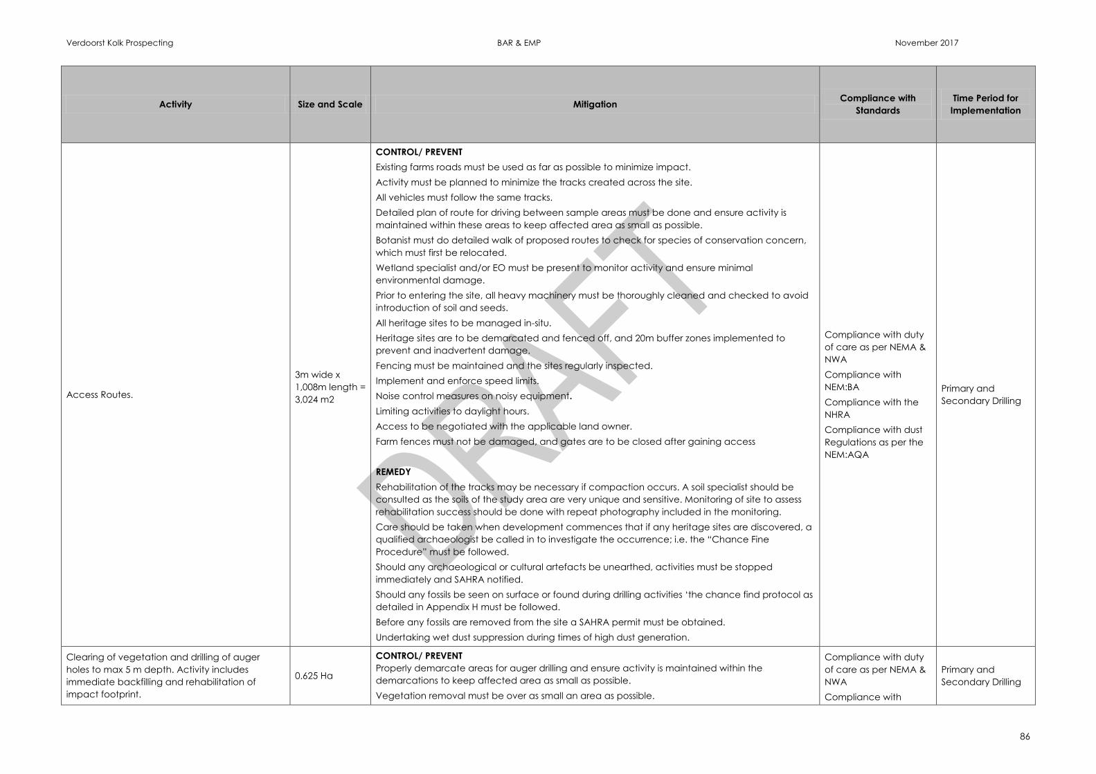
Verdoorst Kolk Prospecting BAR & EMP November 2017
86
Activity Size and Scale Mitigation Compliance with
Standards
Time Period for
Implementation
Access Routes.
3m wide x
1,008m length =
3,024 m2
CONTROL/ PREVENT
Existing farms roads must be used as far as possible to minimize impact.
Activity must be planned to minimize the tracks created across the site.
All vehicles must follow the same tracks.
Detailed plan of route for driving between sample areas must be done and ensure activity is
maintained within these areas to keep affected area as small as possible.
Botanist must do detailed walk of proposed routes to check for species of conservation concern,
which must first be relocated.
Wetland specialist and/or EO must be present to monitor activity and ensure minimal
environmental damage.
Prior to entering the site, all heavy machinery must be thoroughly cleaned and checked to avoid
introduction of soil and seeds.
All heritage sites to be managed in-situ.
Heritage sites are to be demarcated and fenced off, and 20m buffer zones implemented to
prevent and inadvertent damage.
Fencing must be maintained and the sites regularly inspected.
Implement and enforce speed limits.
Noise control measures on noisy equipment.
Limiting activities to daylight hours.
Access to be negotiated with the applicable land owner.
Farm fences must not be damaged, and gates are to be closed after gaining access
REMEDY
Rehabilitation of the tracks may be necessary if compaction occurs. A soil specialist should be
consulted as the soils of the study area are very unique and sensitive. Monitoring of site to assess
rehabilitation success should be done with repeat photography included in the monitoring.
Care should be taken when development commences that if any heritage sites are discovered, a
qualified archaeologist be called in to investigate the occurrence; i.e. the “Chance Fine
Procedure” must be followed.
Should any archaeological or cultural artefacts be unearthed, activities must be stopped
immediately and SAHRA notified.
Should any fossils be seen on surface or found during drilling activities ‘the chance find protocol as
detailed in Appendix H must be followed.
Before any fossils are removed from the site a SAHRA permit must be obtained.
Undertaking wet dust suppression during times of high dust generation.
Compliance with duty
of care as per NEMA &
NWA
Compliance with
NEM:BA
Compliance with the
NHRA
Compliance with dust
Regulations as per the
NEM:AQA
Primary and
Secondary Drilling
Clearing of vegetation and drilling of auger
holes to max 5 m depth. Activity includes
immediate backfilling and rehabilitation of
impact footprint.
0.625 Ha
CONTROL/ PREVENT
Properly demarcate areas for auger drilling and ensure activity is maintained within the
demarcations to keep affected area as small as possible.
Vegetation removal must be over as small an area as possible.
Compliance with duty
of care as per NEMA &
NWA
Compliance with
Primary and
Secondary Drilling
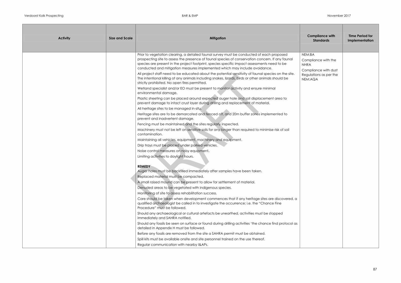
Verdoorst Kolk Prospecting BAR & EMP November 2017
87
Activity Size and Scale Mitigation Compliance with
Standards
Time Period for
Implementation
Prior to vegetation clearing, a detailed faunal survey must be conducted of each proposed
prospecting site to assess the presence of faunal species of conservation concern. If any faunal
species are present in the project footprint, species specific impact assessments need to be
conducted and mitigation measures implemented which may include avoidance.
All project staff need to be educated about the potential sensitivity of faunal species on the site.
The intentional killing of any animals including snakes, lizards, birds or other animals should be
strictly prohibited. No open fires permitted.
Wetland specialist and/or EO must be present to monitor activity and ensure minimal
environmental damage.
Plastic sheeting can be placed around expected auger hole and soil displacement area to
prevent damage to intact crust layer during drilling and replacement of material.
All heritage sites to be managed in-situ.
Heritage sites are to be demarcated and fenced off, and 20m buffer zones implemented to
prevent and inadvertent damage.
Fencing must be maintained and the sites regularly inspected.
Machinery must not be left on sensitive soils for any longer than required to minimise risk of soil
contamination.
Maintaining all vehicles, equipment, machinery and equipment.
Drip trays must be placed under parked vehicles.
Noise control measures on noisy equipment.
Limiting activities to daylight hours.
REMEDY
Auger holes must be backfilled immediately after samples have been taken.
Replaced material must be compacted.
A small raised mound can be present to allow for settlement of material.
Denuded areas to be vegetated with indigenous species.
Monitoring of site to assess rehabilitation success.
Care should be taken when development commences that if any heritage sites are discovered, a
qualified archaeologist be called in to investigate the occurrence; i.e. the “Chance Fine
Procedure” must be followed.
Should any archaeological or cultural artefacts be unearthed, activities must be stopped
immediately and SAHRA notified.
Should any fossils be seen on surface or found during drilling activities ‘the chance find protocol as
detailed in Appendix H must be followed.
Before any fossils are removed from the site a SAHRA permit must be obtained.
Spill kits must be available onsite and site personnel trained on the use thereof.
Regular communication with nearby I&APs.
NEM:BA
Compliance with the
NHRA
Compliance with dust
Regulations as per the
NEM:AQA
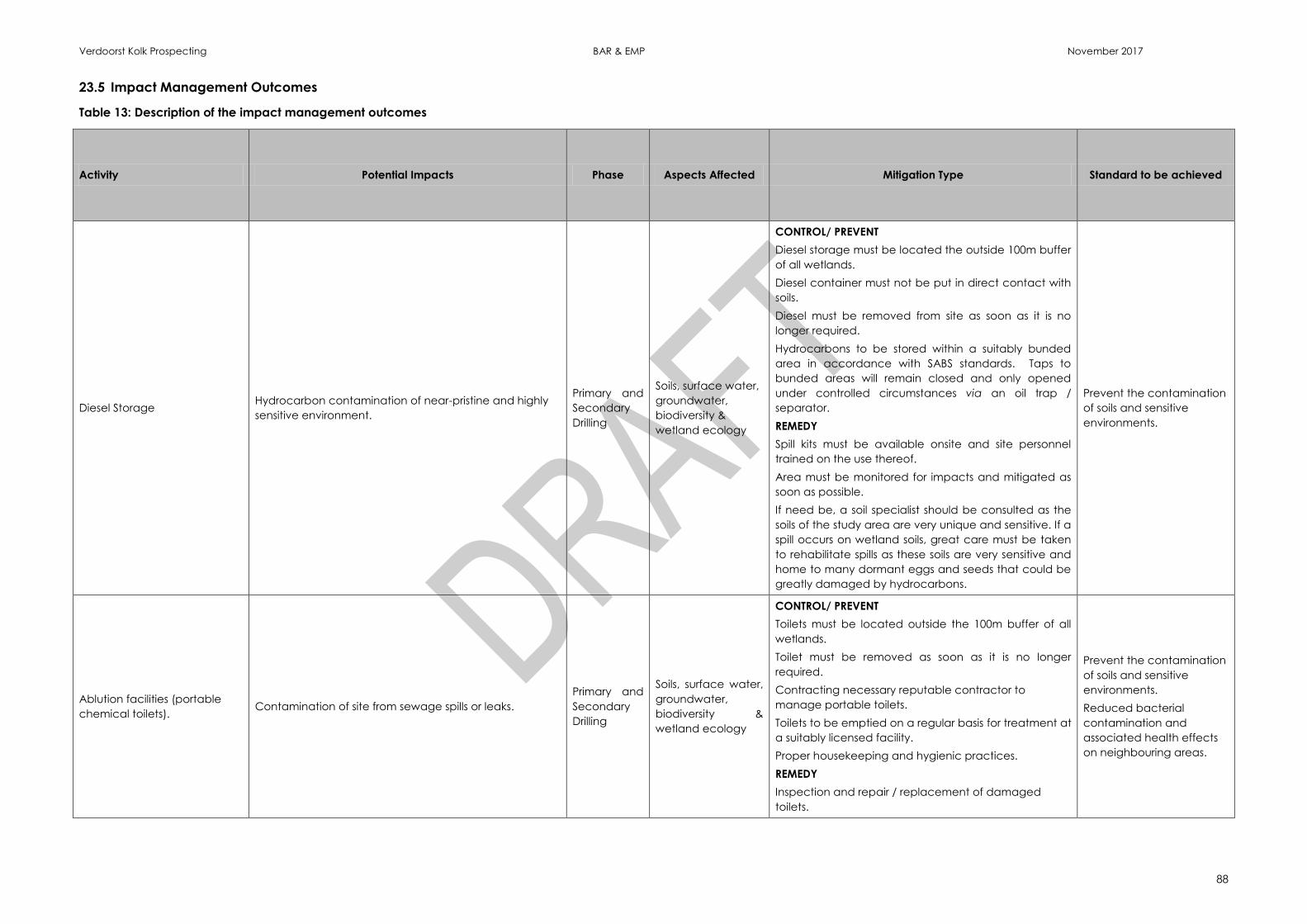
Verdoorst Kolk Prospecting BAR & EMP November 2017
88
23.5 Impact Management Outcomes
Table 13: Description of the impact management outcomes
Activity Potential Impacts Phase Aspects Affected Mitigation Type Standard to be achieved
Diesel Storage Hydrocarbon contamination of near-pristine and highly
sensitive environment.
Primary and
Secondary
Drilling
Soils, surface water,
groundwater,
biodiversity &
wetland ecology
CONTROL/ PREVENT
Diesel storage must be located the outside 100m buffer
of all wetlands.
Diesel container must not be put in direct contact with
soils.
Diesel must be removed from site as soon as it is no
longer required.
Hydrocarbons to be stored within a suitably bunded
area in accordance with SABS standards. Taps to
bunded areas will remain closed and only opened
under controlled circumstances via an oil trap /
separator.
REMEDY
Spill kits must be available onsite and site personnel
trained on the use thereof.
Area must be monitored for impacts and mitigated as
soon as possible.
If need be, a soil specialist should be consulted as the
soils of the study area are very unique and sensitive. If a
spill occurs on wetland soils, great care must be taken
to rehabilitate spills as these soils are very sensitive and
home to many dormant eggs and seeds that could be
greatly damaged by hydrocarbons.
Prevent the contamination
of soils and sensitive
environments.
Ablution facilities (portable
chemical toilets). Contamination of site from sewage spills or leaks.
Primary and
Secondary
Drilling
Soils, surface water,
groundwater,
biodiversity &
wetland ecology
CONTROL/ PREVENT
Toilets must be located outside the 100m buffer of all
wetlands.
Toilet must be removed as soon as it is no longer
required.
Contracting necessary reputable contractor to
manage portable toilets.
Toilets to be emptied on a regular basis for treatment at
a suitably licensed facility.
Proper housekeeping and hygienic practices.
REMEDY
Inspection and repair / replacement of damaged
toilets.
Prevent the contamination
of soils and sensitive
environments.
Reduced bacterial
contamination and
associated health effects
on neighbouring areas.
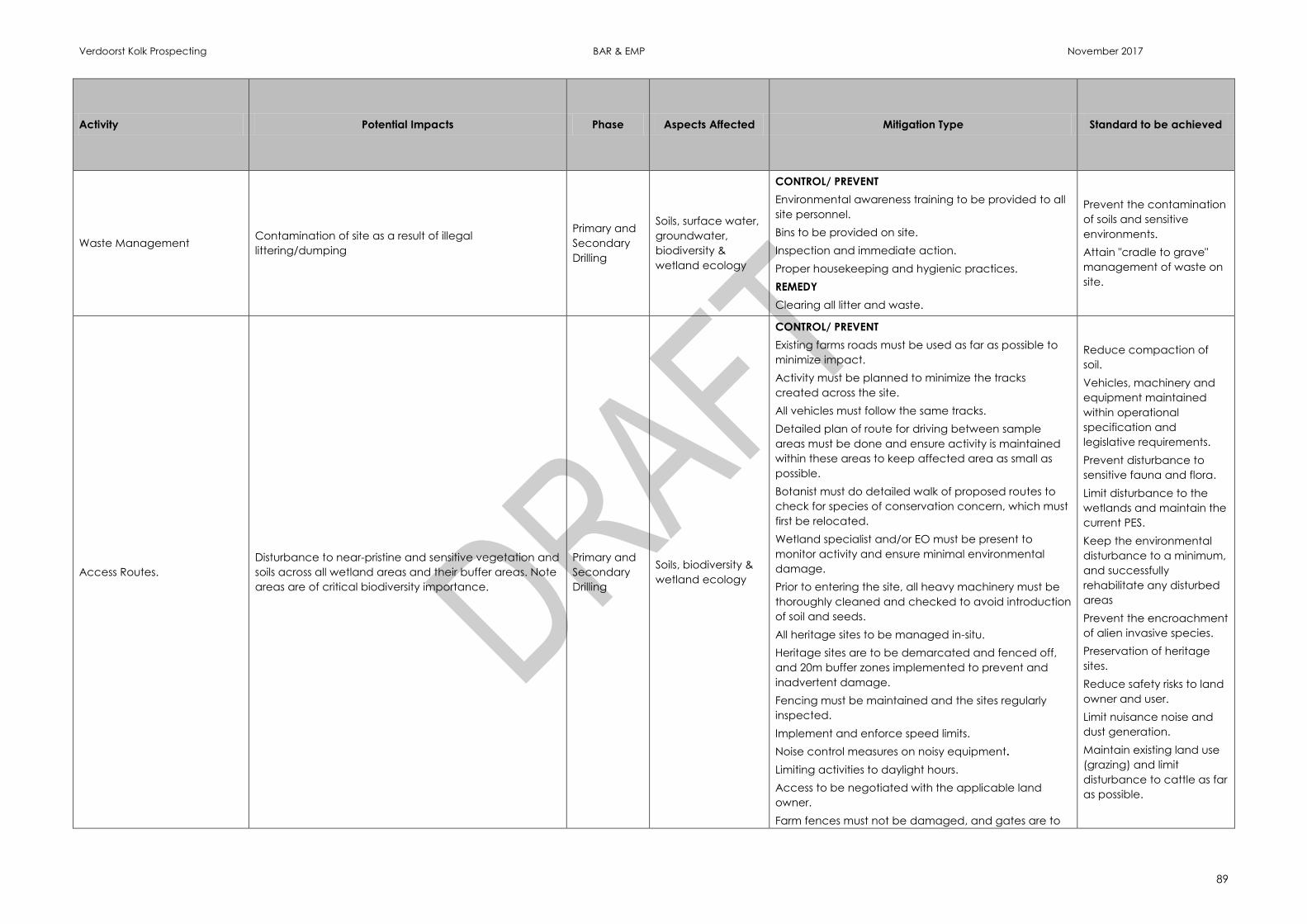
Verdoorst Kolk Prospecting BAR & EMP November 2017
89
Activity Potential Impacts Phase Aspects Affected Mitigation Type Standard to be achieved
Waste Management Contamination of site as a result of illegal
littering/dumping
Primary and
Secondary
Drilling
Soils, surface water,
groundwater,
biodiversity &
wetland ecology
CONTROL/ PREVENT
Environmental awareness training to be provided to all
site personnel.
Bins to be provided on site.
Inspection and immediate action.
Proper housekeeping and hygienic practices.
REMEDY
Clearing all litter and waste.
Prevent the contamination
of soils and sensitive
environments.
Attain "cradle to grave"
management of waste on
site.
Access Routes.
Disturbance to near-pristine and sensitive vegetation and
soils across all wetland areas and their buffer areas. Note
areas are of critical biodiversity importance.
Primary and
Secondary
Drilling
Soils, biodiversity &
wetland ecology
CONTROL/ PREVENT
Existing farms roads must be used as far as possible to
minimize impact.
Activity must be planned to minimize the tracks
created across the site.
All vehicles must follow the same tracks.
Detailed plan of route for driving between sample
areas must be done and ensure activity is maintained
within these areas to keep affected area as small as
possible.
Botanist must do detailed walk of proposed routes to
check for species of conservation concern, which must
first be relocated.
Wetland specialist and/or EO must be present to
monitor activity and ensure minimal environmental
damage.
Prior to entering the site, all heavy machinery must be
thoroughly cleaned and checked to avoid introduction
of soil and seeds.
All heritage sites to be managed in-situ.
Heritage sites are to be demarcated and fenced off,
and 20m buffer zones implemented to prevent and
inadvertent damage.
Fencing must be maintained and the sites regularly
inspected.
Implement and enforce speed limits.
Noise control measures on noisy equipment.
Limiting activities to daylight hours.
Access to be negotiated with the applicable land
owner.
Farm fences must not be damaged, and gates are to
Reduce compaction of
soil.
Vehicles, machinery and
equipment maintained
within operational
specification and
legislative requirements.
Prevent disturbance to
sensitive fauna and flora.
Limit disturbance to the
wetlands and maintain the
current PES.
Keep the environmental
disturbance to a minimum,
and successfully
rehabilitate any disturbed
areas
Prevent the encroachment
of alien invasive species.
Preservation of heritage
sites.
Reduce safety risks to land
owner and user.
Limit nuisance noise and
dust generation.
Maintain existing land use
(grazing) and limit
disturbance to cattle as far
as possible.
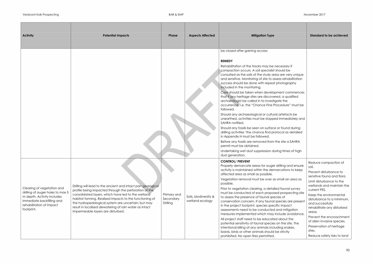
Verdoorst Kolk Prospecting BAR & EMP November 2017
90
Activity Potential Impacts Phase Aspects Affected Mitigation Type Standard to be achieved
be closed after gaining access
REMEDY
Rehabilitation of the tracks may be necessary if
compaction occurs. A soil specialist should be
consulted as the soils of the study area are very unique
and sensitive. Monitoring of site to assess rehabilitation
success should be done with repeat photography
included in the monitoring.
Care should be taken when development commences
that if any heritage sites are discovered, a qualified
archaeologist be called in to investigate the
occurrence; i.e. the “Chance Fine Procedure” must be
followed.
Should any archaeological or cultural artefacts be
unearthed, activities must be stopped immediately and
SAHRA notified.
Should any fossils be seen on surface or found during
drilling activities ‘the chance find protocol as detailed
in Appendix H must be followed.
Before any fossils are removed from the site a SAHRA
permit must be obtained.
Undertaking wet dust suppression during times of high
dust generation.
Clearing of vegetation and
drilling of auger holes to max 5
m depth. Activity includes
immediate backfilling and
rehabilitation of impact
footprint.
Drilling will lead to the ancient and intact pan geological
profile being impacted through the perforation of the
consolidated layers, which have led to the wetland
habitat forming. Realised impacts to the functioning of
the hydropedological system are uncertain; but may
result in localised dewatering of rain water as intact
impermeable layers are disturbed.
Primary and
Secondary
Drilling
Soils, biodiversity &
wetland ecology
CONTROL/ PREVENT
Properly demarcate areas for auger drilling and ensure
activity is maintained within the demarcations to keep
affected area as small as possible.
Vegetation removal must be over as small an area as
possible.
Prior to vegetation clearing, a detailed faunal survey
must be conducted of each proposed prospecting site
to assess the presence of faunal species of
conservation concern. If any faunal species are present
in the project footprint, species specific impact
assessments need to be conducted and mitigation
measures implemented which may include avoidance.
All project staff need to be educated about the
potential sensitivity of faunal species on the site. The
intentional killing of any animals including snakes,
lizards, birds or other animals should be strictly
prohibited. No open fires permitted.
Reduce compaction of
soil.
Prevent disturbance to
sensitive fauna and flora.
Limit disturbance to the
wetlands and maintain the
current PES.
Keep the environmental
disturbance to a minimum,
and successfully
rehabilitate any disturbed
areas
Prevent the encroachment
of alien invasive species.
Preservation of heritage
sites.
Reduce safety risks to land
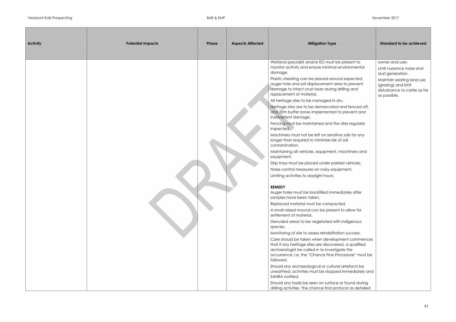
Verdoorst Kolk Prospecting BAR & EMP November 2017
91
Activity Potential Impacts Phase Aspects Affected Mitigation Type Standard to be achieved
Wetland specialist and/or EO must be present to
monitor activity and ensure minimal environmental
damage.
Plastic sheeting can be placed around expected
auger hole and soil displacement area to prevent
damage to intact crust layer during drilling and
replacement of material.
All heritage sites to be managed in-situ.
Heritage sites are to be demarcated and fenced off,
and 20m buffer zones implemented to prevent and
inadvertent damage.
Fencing must be maintained and the sites regularly
inspected.
Machinery must not be left on sensitive soils for any
longer than required to minimise risk of soil
contamination.
Maintaining all vehicles, equipment, machinery and
equipment.
Drip trays must be placed under parked vehicles.
Noise control measures on noisy equipment.
Limiting activities to daylight hours.
REMEDY
Auger holes must be backfilled immediately after
samples have been taken.
Replaced material must be compacted.
A small raised mound can be present to allow for
settlement of material.
Denuded areas to be vegetated with indigenous
species.
Monitoring of site to assess rehabilitation success.
Care should be taken when development commences
that if any heritage sites are discovered, a qualified
archaeologist be called in to investigate the
occurrence; i.e. the “Chance Fine Procedure” must be
followed.
Should any archaeological or cultural artefacts be
unearthed, activities must be stopped immediately and
SAHRA notified.
Should any fossils be seen on surface or found during
drilling activities ‘the chance find protocol as detailed
owner and user.
Limit nuisance noise and
dust generation.
Maintain existing land use
(grazing) and limit
disturbance to cattle as far
as possible.
Verdoorst Kolk Prospecting BAR & EMP November 2017
92
Activity Potential Impacts Phase Aspects Affected Mitigation Type Standard to be achieved
in Appendix H must be followed.
Before any fossils are removed from the site a SAHRA
permit must be obtained.
Spill kits must be available onsite and site personnel
trained on the use thereof.
Regular communication with nearby I&APs.
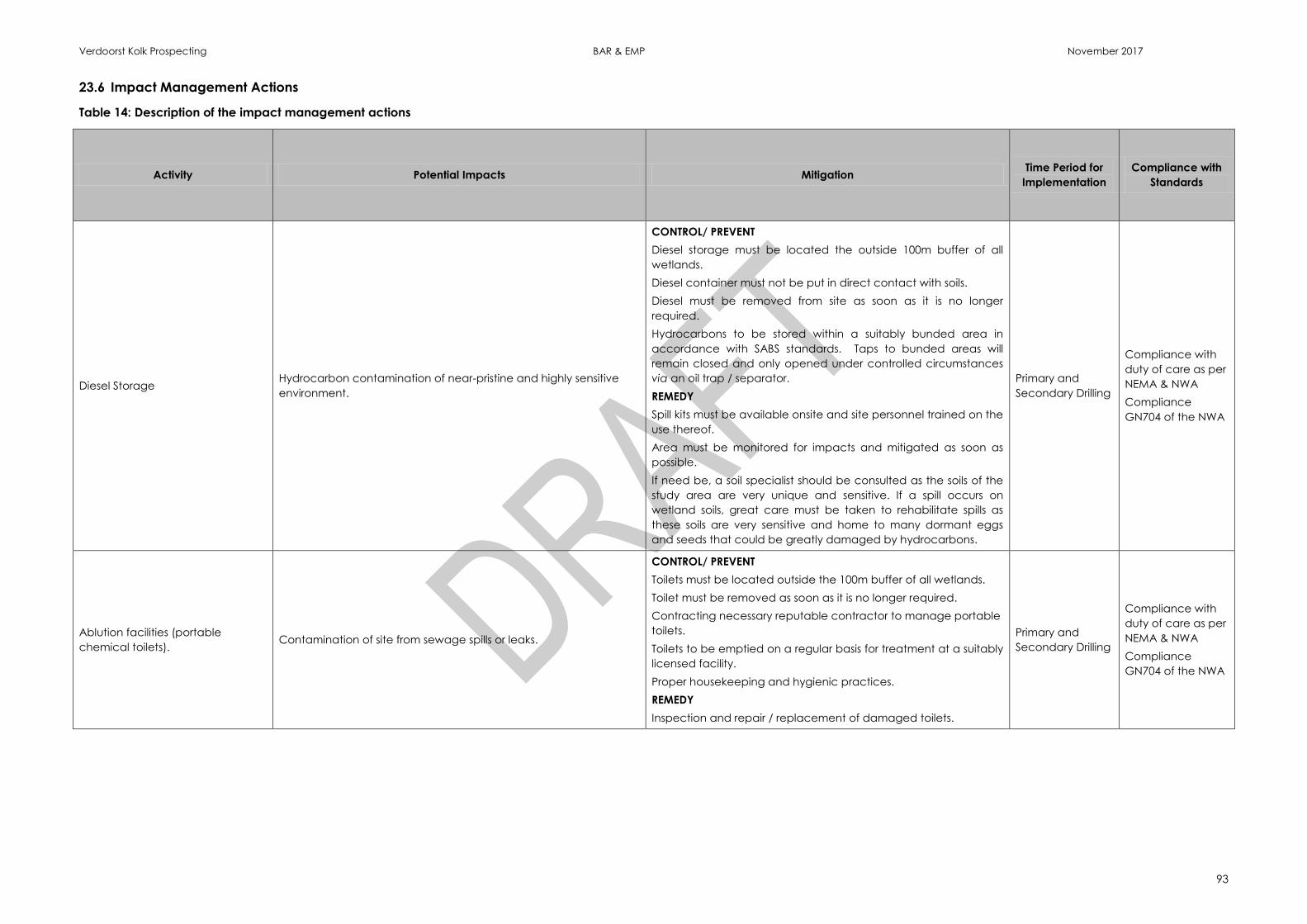
Verdoorst Kolk Prospecting BAR & EMP November 2017
93
23.6 Impact Management Actions
Table 14: Description of the impact management actions
Activity Potential Impacts Mitigation Time Period for
Implementation
Compliance with
Standards
Diesel Storage Hydrocarbon contamination of near-pristine and highly sensitive
environment.
CONTROL/ PREVENT
Diesel storage must be located the outside 100m buffer of all
wetlands.
Diesel container must not be put in direct contact with soils.
Diesel must be removed from site as soon as it is no longer
required.
Hydrocarbons to be stored within a suitably bunded area in
accordance with SABS standards. Taps to bunded areas will
remain closed and only opened under controlled circumstances
via an oil trap / separator.
REMEDY
Spill kits must be available onsite and site personnel trained on the
use thereof.
Area must be monitored for impacts and mitigated as soon as
possible.
If need be, a soil specialist should be consulted as the soils of the
study area are very unique and sensitive. If a spill occurs on
wetland soils, great care must be taken to rehabilitate spills as
these soils are very sensitive and home to many dormant eggs
and seeds that could be greatly damaged by hydrocarbons.
Primary and
Secondary Drilling
Compliance with
duty of care as per
NEMA & NWA
Compliance
GN704 of the NWA
Ablution facilities (portable
chemical toilets). Contamination of site from sewage spills or leaks.
CONTROL/ PREVENT
Toilets must be located outside the 100m buffer of all wetlands.
Toilet must be removed as soon as it is no longer required.
Contracting necessary reputable contractor to manage portable
toilets.
Toilets to be emptied on a regular basis for treatment at a suitably
licensed facility.
Proper housekeeping and hygienic practices.
REMEDY
Inspection and repair / replacement of damaged toilets.
Primary and
Secondary Drilling
Compliance with
duty of care as per
NEMA & NWA
Compliance
GN704 of the NWA
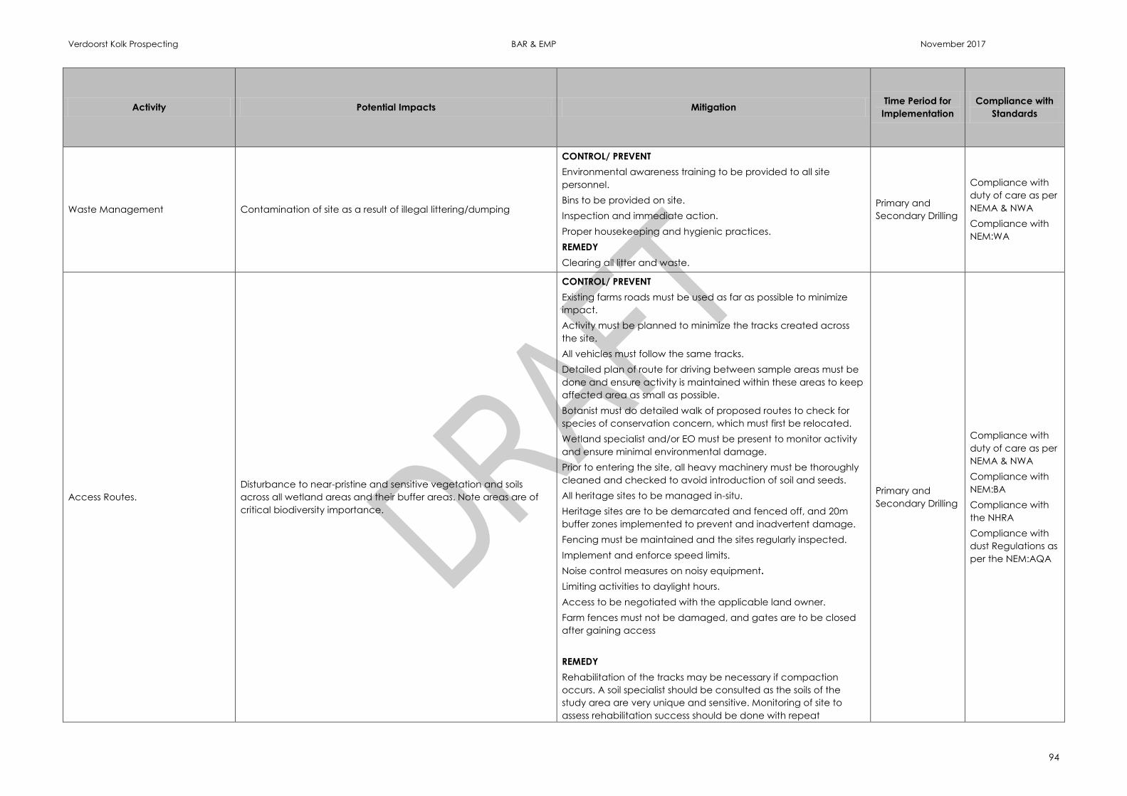
Verdoorst Kolk Prospecting BAR & EMP November 2017
94
Activity Potential Impacts Mitigation Time Period for
Implementation
Compliance with
Standards
Waste Management Contamination of site as a result of illegal littering/dumping
CONTROL/ PREVENT
Environmental awareness training to be provided to all site
personnel.
Bins to be provided on site.
Inspection and immediate action.
Proper housekeeping and hygienic practices.
REMEDY
Clearing all litter and waste.
Primary and
Secondary Drilling
Compliance with
duty of care as per
NEMA & NWA
Compliance with
NEM:WA
Access Routes.
Disturbance to near-pristine and sensitive vegetation and soils
across all wetland areas and their buffer areas. Note areas are of
critical biodiversity importance.
CONTROL/ PREVENT
Existing farms roads must be used as far as possible to minimize
impact.
Activity must be planned to minimize the tracks created across
the site.
All vehicles must follow the same tracks.
Detailed plan of route for driving between sample areas must be
done and ensure activity is maintained within these areas to keep
affected area as small as possible.
Botanist must do detailed walk of proposed routes to check for
species of conservation concern, which must first be relocated.
Wetland specialist and/or EO must be present to monitor activity
and ensure minimal environmental damage.
Prior to entering the site, all heavy machinery must be thoroughly
cleaned and checked to avoid introduction of soil and seeds.
All heritage sites to be managed in-situ.
Heritage sites are to be demarcated and fenced off, and 20m
buffer zones implemented to prevent and inadvertent damage.
Fencing must be maintained and the sites regularly inspected.
Implement and enforce speed limits.
Noise control measures on noisy equipment.
Limiting activities to daylight hours.
Access to be negotiated with the applicable land owner.
Farm fences must not be damaged, and gates are to be closed
after gaining access
REMEDY
Rehabilitation of the tracks may be necessary if compaction
occurs. A soil specialist should be consulted as the soils of the
study area are very unique and sensitive. Monitoring of site to
assess rehabilitation success should be done with repeat
Primary and
Secondary Drilling
Compliance with
duty of care as per
NEMA & NWA
Compliance with
NEM:BA
Compliance with
the NHRA
Compliance with
dust Regulations as
per the NEM:AQA
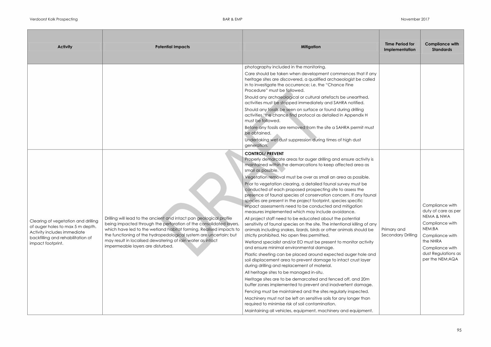
Verdoorst Kolk Prospecting BAR & EMP November 2017
95
Activity Potential Impacts Mitigation Time Period for
Implementation
Compliance with
Standards
photography included in the monitoring.
Care should be taken when development commences that if any
heritage sites are discovered, a qualified archaeologist be called
in to investigate the occurrence; i.e. the “Chance Fine
Procedure” must be followed.
Should any archaeological or cultural artefacts be unearthed,
activities must be stopped immediately and SAHRA notified.
Should any fossils be seen on surface or found during drilling
activities ‘the chance find protocol as detailed in Appendix H
must be followed.
Before any fossils are removed from the site a SAHRA permit must
be obtained.
Undertaking wet dust suppression during times of high dust
generation.
Clearing of vegetation and drilling
of auger holes to max 5 m depth.
Activity includes immediate
backfilling and rehabilitation of
impact footprint.
Drilling will lead to the ancient and intact pan geological profile
being impacted through the perforation of the consolidated layers,
which have led to the wetland habitat forming. Realised impacts to
the functioning of the hydropedological system are uncertain; but
may result in localised dewatering of rain water as intact
impermeable layers are disturbed.
CONTROL/ PREVENT
Properly demarcate areas for auger drilling and ensure activity is
maintained within the demarcations to keep affected area as
small as possible.
Vegetation removal must be over as small an area as possible.
Prior to vegetation clearing, a detailed faunal survey must be
conducted of each proposed prospecting site to assess the
presence of faunal species of conservation concern. If any faunal
species are present in the project footprint, species specific
impact assessments need to be conducted and mitigation
measures implemented which may include avoidance.
All project staff need to be educated about the potential
sensitivity of faunal species on the site. The intentional killing of any
animals including snakes, lizards, birds or other animals should be
strictly prohibited. No open fires permitted.
Wetland specialist and/or EO must be present to monitor activity
and ensure minimal environmental damage.
Plastic sheeting can be placed around expected auger hole and
soil displacement area to prevent damage to intact crust layer
during drilling and replacement of material.
All heritage sites to be managed in-situ.
Heritage sites are to be demarcated and fenced off, and 20m
buffer zones implemented to prevent and inadvertent damage.
Fencing must be maintained and the sites regularly inspected.
Machinery must not be left on sensitive soils for any longer than
required to minimise risk of soil contamination.
Maintaining all vehicles, equipment, machinery and equipment.
Primary and
Secondary Drilling
Compliance with
duty of care as per
NEMA & NWA
Compliance with
NEM:BA
Compliance with
the NHRA
Compliance with
dust Regulations as
per the NEM:AQA
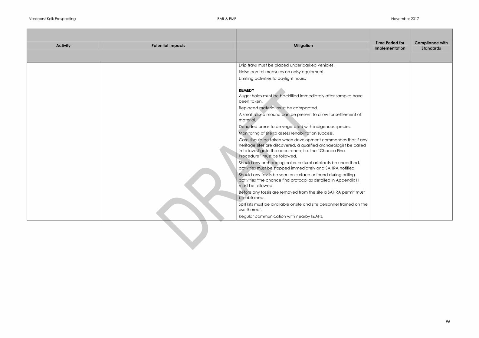
Verdoorst Kolk Prospecting BAR & EMP November 2017
96
Activity Potential Impacts Mitigation Time Period for
Implementation
Compliance with
Standards
Drip trays must be placed under parked vehicles.
Noise control measures on noisy equipment.
Limiting activities to daylight hours.
REMEDY
Auger holes must be backfilled immediately after samples have
been taken.
Replaced material must be compacted.
A small raised mound can be present to allow for settlement of
material.
Denuded areas to be vegetated with indigenous species.
Monitoring of site to assess rehabilitation success.
Care should be taken when development commences that if any
heritage sites are discovered, a qualified archaeologist be called
in to investigate the occurrence; i.e. the “Chance Fine
Procedure” must be followed.
Should any archaeological or cultural artefacts be unearthed,
activities must be stopped immediately and SAHRA notified.
Should any fossils be seen on surface or found during drilling
activities ‘the chance find protocol as detailed in Appendix H
must be followed.
Before any fossils are removed from the site a SAHRA permit must
be obtained.
Spill kits must be available onsite and site personnel trained on the
use thereof.
Regular communication with nearby I&APs.

Verdoorst Kolk Prospecting BAR & EMP November 2017
97
24 FINANCIAL PROVISION
24.1 Describe the closure objectives and the extent to which they have been
aligned to the baseline environment described under the Regulation.
The closure objectives are:
Ensure rehabilitated areas are physically stable and free draining;
Ensure the functionality of the environment as well as the current land use is
not adversely affected; and
To ensure that alien invasive establishment and spread on areas disturbed by
prospecting is prevented and controlled.
Eliminate safety threats to animals and humans.
To achieve the closure objectives, Therefore effective mitigation measures need to
be implemented on site to prevent, control and remedy the impacts to the
environment. These measures include:
Locating the site camp and associated diesel storage and chemical toilets
outside of sensitive area (100m from wetland areas).
Inspect and maintain portable toilets to reduce risk of contamination through
sewage spills.
Implementing good housekeeping procedures.
Reduce risk of contamination to the environment from vehicles, machinery,
drill rigs and equipment (emissions, hydrocarbon spills, and excessive noise) by
ensuring regular maintenance of vehicles and machinery. Making drip trays
available at all times, and storing hydrocarbons within SABS approved
bunding.
Keep hydrocarbon spill kits on site at all times to clear any spills that occur.
Bins to be provided and all waste removed from site for disposal at a licensed
facility.
Utilising existing farm roads and tracks as far as possible.
Activities must be planned in consultation with the landowner/user to
minimize the tracks created across the site and disturbance to the current
land use.
Surveying proposed routes and prospecting sites to prevent impact to
heritage sites, fossils and sensitive fauna and flora (to be completed by the
EO and/or specialist where applicable).
Properly demarcate areas for auger drilling and ensure activity is maintained
within the demarcations to keep affected area as small as possible.
Plastic sheeting can be placed around expected auger hole and soil
displacement area to prevent damage to intact crust layer during drilling and
replacement of material.
Auger holes must be backfilled immediately after samples have been taken.
Replaced material must be compacted. A small raised mound can be
present to allow for settlement of material.

Verdoorst Kolk Prospecting BAR & EMP November 2017
98
Denuded areas to be vegetated with indigenous species.
Heritage sites to be fenced off and a 20m buffer implemented.
‘Chance find procedure’ to be implemented should any fossils be
discovered.
Limit activities to daylight hours.
Access to be negotiated with the applicable land owner.
Farm fences must not be damaged, and gates are to be closed after gaining
access.
Regularly communicate prospecting intentions to local land owners / users.
Limit activities to daylight hours.
Consider the use of wet dust suppression to be undertaken during times of
high dust generation.
Establish and enforce speed limits on all roads.
Keep vehicles and machinery free from plant matter to reduce risk of
introduction and spread of alien and invasive species.
Implement the inspection and monitoring plan stipulated in the EMP and take
the necessary action for any issues observed on site.
24.2 Confirm specifically that the environmental objectives in relation to
closure have been consulted with landowner and interested and
affected parties
The BAR and EMP has been made available for public review and comment for a
period of 30 days.
24.3 Provide a rehabilitation plan that describes and shows the scale and
aerial extent of the main mining activities, including the anticipated
mining area at the time of closure
Part A, Figure 21 indicates the aerial extent of the proposed prospecting activities.
Rehabilitation will be undertaken concurrently i.e. auger holes will be rehabilitated
immediately on completion of sampling before continuing to the next site.
Denuded areas will be vegetated with local, indigenous species.
24.4 Explain why it can be confirmed that the rehabilitation plan is
compatible with the closure objectives
The rehabilitation plan aims to mitigate the negative impacts associated with the
prospecting activities ultimately ensuring that functionality of the environment is not
adversely affected, and that the current PES of the wetlands are maintained.
Verdoorst Kolk Prospecting BAR & EMP November 2017
99
24.5 Calculate and state the quantum of the financial provision required to
manage and rehabilitate the environment in accordance with the
applicable guideline
Table 15: Rehabilitation Cost Estimate
Total Disturbance Footprints Number Area (m2)
Equipment storage and sample laydown area 5 1000
Camp area 5 500
Fuel storage area 5 125
Chemical toilets area 2 10
Temporary access routes/tracks in meters 1052 3157
300mm Diameter Auger Drilled Holes to 5m max 250 6250
Total Affected Area (meters squared) 11041.67
Estimated Total Rehabilitation Costs
Rates Cost
General surface rehab (R/ha) R100 000.00 R110 416.67
Sealing of Auger Holes (R/hole) R350.00 R 87 500.00
Aftercare (R/ha) R20 000.00 R 22 083.33
Grand total R 220 000.00
24.6 Confirm that the financial provision will be provided as determined
A signed undertaking and proof of funds will be submitted to the DMR upon request.
Verdoorst Kolk Prospecting BAR & EMP November 2017
100
25 MECHANISMS FOR MONITORING COMPLIANCE
Mechanisms for monitoring compliance with and performance assessment against the environmental management programme and reporting thereon, including
Monitoring of Impact Management Actions
Monitoring and reporting frequency
Responsible persons
Time period for implementing impact management actions
Mechanism for monitoring compliance
SOURCE ACTIVITY IMPACTS REQUIRING MONITORING
PROGRAMMES
FUNCTIONAL REQUIREMENTS FOR
MONITORING
ROLES AND RESPONSIBILITIES
(FOR THE EXECUTION OF THE
MONITORING PROGRAMMES)
MONITORING AND REPORTING FREQUENCY and TIME
PERIODS FOR IMPLEMENTING IMPACT MANAGEMENT
ACTIONS
General housekeeping inspections General day-to-day compliance with EMP Visual inspections
Comletion of checklists to be kept
on file
Geologist / Site Manager Weekly inspections as prospecting progresses.
Internal EMP performance
assessment
Compliance with the approved EMP and
conditions stipulated within EA
Formal audit report for internal
purposes
Geologist / Site Manager Annually
External EMP performance
assessment and environmental
compliance
Compliance with the approved EMP and
conditions stipulated within EA
Compliance with NEMA and NWA Regulations.
Formal audit report for submission
to the Competant Authorities
EAP Annually
Rehabilitation monitorin Rehabilitation to be undertaken in terms of the
work method statemetn and rehabilitation
plan
Rehabilitation success monitoring
Photograph record to be
maintained
Sign off by landowner
Geologist / Site Manager Monthly as prospecting progresses
Verdoorst Kolk Prospecting BAR & EMP November 2017
101
25.1 Indicate the frequency of the submission of the Performance Assessment
Report
An annual performance assessment (or at a frequency stipulated in the EA) will be
conducted by an external consultant throughout the life of prospecting as required
under NEMA. This is conducted to assess the adequacy and compliance to the EMP,
EA and the relevant legislation.
26 ENVIRONMENTAL AWARENESS PLAN
26.1 Manner in which the applicant intends to inform his or her employees of
any environmental risk which may result from their work
The Geologist and Site Manager must be conversant in environmental legislation,
with special reference to the MPRDA, NEMA and the NWA.
The contractor / driller will be responsible for training its staff in terms of general
environmental awareness. This will include basic training on the contents of this EMP;
and will be conducted prior to commencement of prospecting activities. The aim of
the environmental awareness training will be to highlight the potential impacts of the
prospecting activities, and to highlight no-go areas.
The contractor / driller will ensure that records are kept of all training sessions /
inductions. The Environmental Manager will monitor these records and undertake
regular follow ups.
26.2 Manner in which risks will be dealt with in order to avoid pollution or the
degradation of the environment
Training, as detailed above, will address the specific measures and actions as listed
in the EMP and also conditions of the environmental authorisation (EA). In this way
the prospecting team will be provided the knowledge required to conduct the
prospecting activities without resulting in environmental non-compliance, the liability
of which would lie with Witkop. Secondly, informing the prospecting team of the EMP
will also assist the team in identifying if an impact is likely to occur / has occurred
and communicate this appropriately to the Environmental Manager.
In order for appropriate action to be taken, proper communications network and
reporting protocol must be established.
27 SPECIFIC INFORMATION REQUIRED BY THE COMPETENT AUTHORITY
Any requirements made by the authority or under the conditions of the EA will be
attended to.
The financial provision will be reviewed annually.
28 UNDERTAKING
The EAP herewith confirms
the correctness of the information provided in the reports ☐
the inclusion of comments and inputs from stakeholders and I&APs ; ☐
the inclusion of inputs and recommendations from the specialist reports where
relevant; ☐ and
that the information provided by the EAP to interested and affected parties
and any responses by the EAP to comments or inputs made by interested and
affected. parties are correctly reflected herein; ☐
_______________________________________________________________
Signature of the environmental assessment practitioner:
_______________________________________________________________
Name of company:
_______________________________________________________________
Date:
-END-