PROPERTY, LOCATION AND ACCESS
42
Transcript of PROPERTY, LOCATION AND ACCESS
jnorris
Text Box
BC Geological Survey Assessment Report 38051
ARCHER, CATHRO & ASSOCIATES (1981) LIMITED 1016 – 510 West Hastings Street
Vancouver, B.C. V6B 1L8 Telephone: 604-688-2568 Fax: 604-688-2578
ASSESSMENT REPORT
describing
PROSPECTING AND GEOCHEMICAL SAMPLING
Field work performed on August 4 and from September 18 to 23, 2018
at the
URSULA SOUTH PROPERTY
NTS 93O/14 Latitude 5558΄N; Longitude 1239΄W
in the
Liard Mining Division, British Columbia
prepared by
Archer, Cathro & Associates (1981) Limited
for
ETHOS GOLD CORP.
by
J. Morton, B.Sc., P.Geo.
December 2018
Archer, Cathro & Associates (1981) Limited Ursula South Property Assessment Report December 2018
CONTENTS
INTRODUCTION 1
LOCATION, PHYSIOGRAPHY, VEGETATION, ACCESS AND CLIMATE 1
CLAIMS 1
HISTORY AND PREVIOUS WORK 2
REGIONAL GEOLOGY 2
PROPERTY GEOLOGY 4
REGIONAL MINERALIZATION 5
PROPERTY MINERALIZATION 5
STREAM SEDIMENT GEOCHEMISTRY 6
DISCUSSION AND CONCLUSIONS 7
REFERENCES 8
APPENDICES
I STATEMENTS OF QUALIFICATIONS
II STATEMENT OF COSTS
III ROCK SAMPLE DESCRIPTIONS
IV CERTIFICATES OF ANALYSIS
V ROCK AND SILT GEOCHEMITRY FIGURES

Archer, Cathro & Associates (1981) Limited Ursula South Property Assessment Report December 2018
TABLES
No. Description Page
I 2018 Rock Geochemical Results 6
II 2018 Silt Sample Locations and Geochemical Results 6
FIGURES
No. Description Follows Page
1 Property Location 1
2 Claim Locations 1
3 Tectonic Setting 2
4 Regional Geology 3
5 Rock Sample Locations 5
6 Silt Sample Locations 6
Archer, Cathro & Associates (1981) Limited Ursula South Property Assessment Report December 2018
INTRODUCTION The Ursula South property covers a shale-hosted vanadium prospect. It is located in the Rocky Mountains of northeastern British Columbia. The property is wholly owned by Ethos Gold Corp. This report describes prospecting and geochemical sampling, which were performed on August 4 and from September 18 to 23, 2018. The author participated in the exploration program and interpreted all resulting data. The author’s Statement of Qualifications is provided in Appendix I, and a Statement of Expenditures is provided in Appendix II.
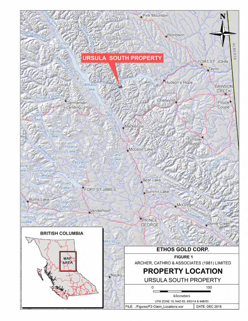
LOCATION, PHYSIOGRAPHY, VEGETATION, ACCESS AND CLIMATE The Ursula South property is located on the eastern flank of the Hart Ranges – part of the Rocky Mountains of northeastern British Columbia – on NTS map sheet 93O/14 (Figure 1). It is situated on the south side of Peace Reach, a branch of the Williston Lake reservoir, at latitude 55°58΄ north and longitude 123°9΄ west. The claim block lies approximately 70 km north of the community of Mackenzie and 143 km west of Fort St. John, which is the closest community with daily flights in and out. In the western part of the property, a small road network is developed along Peace Reach. The closest road access is from the Clearwater Forest Service Road, which connects to highway 97 near Pine Pass and terminates on the south side of Peace Reach, immediately west of the property. The property straddles the boundary between two physiographic units – the Rocky Mountains to the west and the Rocky Mountain Foothills to the east. Both regions are characterized by rugged alpine and subalpine terrain, with lower elevations thickly treed by western larch, subalpine fir and whitebark pine. The property lies entirely below treeline, with elevations ranging from 1370 m above sea level (asl) along an east-west ridge to 700 m asl along the shore of Williston Lake. The climate in the Ursula South area is typical of the northern Rocky Mountains, characterized by long, very cold winters and short, cool to mild summers. Snowfall typically occurs for five to seven months of the year, with snowpacks commonly as deep as two to three metres. The property is generally snow free from May until November. In 2018, access to the property was via a Eurocopter AStar B3 helicopter operated by Buffalo Aerial Services Ltd. from a permanent base in Chetwynd, BC.
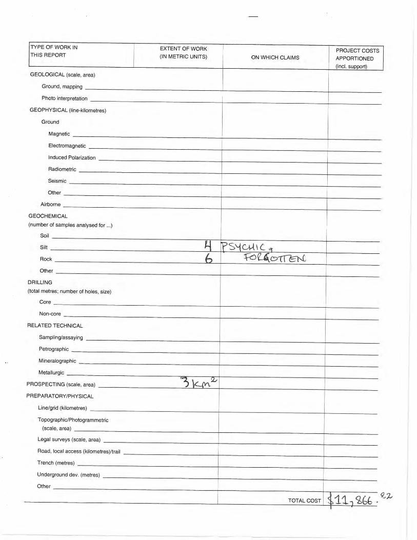
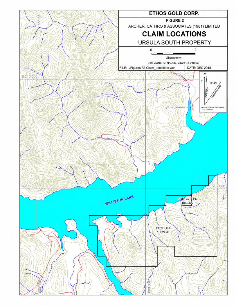
CLAIMS The Ursula South property comprises two mineral tenures that cover an area of 14.05 km2 (1405 ha). The mineral tenures are located in the Liard Mining District and are registered in the name of Ethos Gold Corp. Details concerning the tenures are listed below, and the locations of individual claims are shown in Figure 2.
2
Archer, Cathro & Associates (1981) Limited Ursula South Property Assessment Report December 2018
Tenure Name Tenure Number Expiry Date* PSYCHIC 1062426 August 18, 2020 FORGOTTEN 1062427 August 18, 2020
* Expiry dates include 2018 work, which has been filed for assessment credit but has not yet been accepted.
HISTORY AND PREVIOUS WORK There is no public record of previous exploration in the area covered by the Ursula South property. The earliest reported exploration in the vicinity of the property was performed in 1973 by Union Oil Company of Canada Ltd. At that time, spurred by the discovery of the Robb Lake lead-zinc deposit, Union Oil performed geological reconnaissance in an area 25 km northeast of Ursula South. This work resulted in the identification of the Poco (094B 007) and Coral (094B 008) mineral occurrences, which are hosted in middle Paleozoic shelf carbonates. Subsequent work by Union Oil and other operators included soil geochemical sampling, hand trenching and diamond drilling. In 2016, nine shallow drill holes were completed on the Coral occurrence, which intersected only minor lead-zinc mineralization (deGraaf et al., 2016). In 2007, the Northern Development Initiative Trust and Geoscience BC performed a reconnaissance-scale stream sediment and water survey on NTS map sheet 93O. No samples were collected on the Ursula South property; however, vanadium geochemistry in stream sediment samples was notably elevated south of Peace Reach, along a northwest trending belt of Triassic-aged sedimentary rocks (Jackaman, 2008).
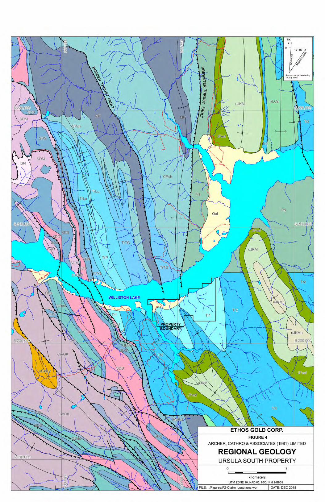
REGIONAL GEOLOGY The Ursula South property is located in the foreland fold-and-thrust belt of western Canada, which records the convergence between the North American craton (Laurentia) and outboard geological terranes (Figure 3). In the northern Rocky Mountains, platformal to basinal sedimentary rocks, which developed along a passive Laurentian margin, were progressively shortened and thickened, beginning in the Mesozoic, as Laurentia began converging with an easterly-dipping subduction zone. The foreland fold-and-thrust belt developed in the region behind the collisional zone, as Paleozoic to Mesozoic volcanic, plutonic, sedimentary and metamorphic assemblages, which represent magmatic arcs, microcontinents and ocean basins, were accreted onto western Laurentia (Colpron and Nelson, 2011). The Ursula South area is underlain by a largely Paleozoic to Triassic stratigraphic succession that comprises a westward-thickening sedimentary prism deposited at the western margin of Laurentia. The prism is defined by overlapping shelf and off-shelf facies that record sea level changes during this time period. In 1986, the Geological Survey of Canada (GSC) published a geological map of the Point Creek (93O/14) area, at a 1:50,000 scale (McMechan, 1986). The following year, this map was

Nome
Juneau
Seward
Inuvik
Calgary
Victoria
Edmonton
Vancouver
Anchorage
Fairbanks
Whitehorse
Yellowknife
Prince Rupert
NAc
NAb
YT
NAp
NAp
AA
CAST
AXKSKS
SMSM
SMSM
QN
NAc
ST
WR
AX
NAp
QN
QN
NAc
NAp
YT
CC
CC
NAbNAb
SMSM
OKOK
SMSM
KY
AA
KY
PEPWPW
CGCG
NAb
WR
RB
RB
FW
AG
YT
YT
YTYAYA
KBKB
100°W108°W
116°W
116°W
124°W
124°W
132°W
132°W
140°W
140°W
148°W
148°W156°W164°W172°W180°
70°N
66°N
66°N
62°N
62°N
58°N
58°N
54°N
54°N50°N
50°N46°N
0 100 200 300
km
Angayucham/Tozitna/Innoko
Farewell
Coldfoot, Ruby,Seward
Arctic-Alaska,Hammond
Koyukuk, Nyak,
Togiak
Kilbuck
Peninsular
Prince
William
Chugach
Cache Creek
Wrangellia
Alexander
Yukon-Tanana
Kluane,
Windy, Coast
Yakutat
Stikinia
Quesnellia
OkanaganNorth America - platform
North America - craton & cover
Cassiar
Methow
North America - basinal
Cadwallader
Chilliwack
Crescent
Bridge River
Harrison
Slide Mountain
Outb
oa
rdIn
sula
r
Inte
rmonta
ne
No
rth
ern
Ala
ska Ancestral North America
AA
RB
FW
KY
KB
AX
WR
PE
CG
PW
YA
KS
AG
YT
OK
ST
QN
HA
CD
CK
MT
PR
CR
NAb
NAp
NAc
CA
BR
SM
CC
YukonFlats
Coast
plutonic
complex
Ala
ska
Yuko
n
NWT
USAUSA
BC
Alb
erta
easte
rn
limit
of
Cordilleran
deformation
PacificOcean
ArcticOcean
ARCHER, CATHRO & ASSOCIATES (1981) LIMITED
TECTONIC SETTING
URSULA SOUTH PROPERTY
FILE: 2018\URSULA DATE: DECEMBER 2018
ETHOS GOLD CORP.
FIGURE 3
Taken from Colpron, M. and Nelson, J.L., 2011
URSULA SOUTH PROPERTY

3
Archer, Cathro & Associates (1981) Limited Ursula South Property Assessment Report December 2018
incorporated into a paper by McMechan (1987) that characterized the stratigraphy and structure of the Mount Selwyn area, south of Peace Reach. Also in 1987, the GSC published a geological map, at 1:50,000 scale, of NTS map sheet 94B/03 and part of 94B/04 (Thompson, 1987), which covers the northern part of Peace Reach. This map was later incorporated into a GSC memoir describing the stratigraphy, structure and tectonic evolution of NTS map sheet 94B (Thompson, 1989). In 2005, the British Columbia Geological Survey (BCGS) completed a compilation of province-wide geology, which updated the lithological unit names in the Ursula South area (Massey et al., 2005). Figure 4 illustrates the geology in the vicinity of the property. The following paragraphs are synthesized from the work by the BCGS and the GSC. The Ursula South property is located immediately east of a structural boundary that juxtaposes Cambrian to Upper Devonian carbonate rocks to the west against Carboniferous to Upper Jurassic carbonate and clastic sedimentary rocks to the east. The boundary defines two structural domains: the Rocky Mountains structural subprovince and the Foothills structural subprovince. The stratigraphy of each subprovince is described in the following six paragraphs. The oldest rocks exposed in the Ursula South area belong to the Rocky Mountain structural subprovince, west of the boundary, and comprise well-bedded, Lynx Formation (uCmLy) shelf carbonates. These are conformably overlain by Kechika Group (CmOK) – a thick succession of argillaceous, thin-bedded limestone, siltstone and shale, which records Late Cambrian subsidence and flooding of the shelf. Toward the end of the Lower Ordovician, shelf carbonates again built westward onto CmOK, resulting in the deposition of Skoki Formation (OSk) dolomite, Muncho-McConnell (SDM) dolostone and Stone Formation (SDD) dolostone and dolomitic quartz sandstone. Unconformably overlying SDD is the Dunnedin Formation (SDS), a thin, dark limestone and calcareous shale, which marks the onset of a protracted period of transgression (Thompson, 1989). East of the structural boundary, the base of the Foothills structural subprovince consists of Besa River Formation (DMBsf) shale, which in the property area is conformably overlain by off-shelf, skeletal to ooid limestone and shale of the Prophet River Formation (MP), as well as a siltstone, shale, sandstone and chert succession that is collectively referred to as CPch. The uppermost member of CPch, the Fantasque Formation, is overlain by a thin, phosphate pebble conglomerate that was deposited during an interval of erosion at the end of the Permian and/or beginning of the Triassic. This period of erosion marks the beginning of Triassic deposition, characterised by stagnant, anoxic to euxninc conditions and limited fluvial influx, which resulted in fine-grained, siliciclastic sedimentation (Thompson, 1989; McMechan, 1987). Two main depositional phases are recorded in the Triassic lithofacies: an early, transgressive facies, comprising Early Triassic Grayling and Early to Middle Triassic Toad formations (TrTG); and a regressive, shallow-water, clastic-evaporitive facies, consisting of Liard, Charlie Lake, Ludington (TrLu), Baldonnel and Pardonet (TrP) formations. In the Ursula South area, Grayling Formation consists of recessive, argillaceous siltstone, dolomitic siltstone and silty shale, which is conformably overlain by Toad Formation siltstone, shale, calcareous siltstone and silty limestone. The contact between Toad Formation and Grayling Formation is gradational, designated mainly on the basis of a change in carbonate composition, and to a lesser degree on bedding thickness and resistance to weathering (Gibson, 1975).


4
Archer, Cathro & Associates (1981) Limited Ursula South Property Assessment Report December 2018
South of the Ursula South area, Toad Formation correlates with the upper Vega-Phroso, Whistler and Llama Members of the Sulphur Mountain Formation, which is notable for its high sedimentary phosphate content. Phosphate occurs in numerous beds throughout the middle part of Toad Formation, as nodules, lenses, phosphate cement and occasionally as pellets and phosphatized fossil debris (Butrenchuk, 1996). Open marine conditions persisted until late Middle Triassic. At this time, a progradational, shallow-water, cross-laminated, calcareous and evaporitic sandstone facies spread southwestward across the Grayling and Toad formations, resulting in the deposition of the Liard and Charlie Lake formations (TrLCs), and the Ludington Formation (TrLu) – a lateral, deeper-water equivalent of Charlie Lake (Thompson, 1989). In the property area, TrLu comprises a thick (up to 960 m) sequence of medium to pale grey weathering, dolomitic to calcareous siltstone, sandstone and bioclastic limestone. It is overlain, in an uncertain relationship, by the cliff-forming limestone and dolostone of the Baldonnel Formation, and the thin-bedded, very dark grey weathering limestone and siltstone of the Pardonet Formation (TrP). The Baldonnel Formation is sparsely fossiliferous, whereas the bioclastic limestone of TrP is one of the most fossiliferous units of the Triassic lithofacies (Gibson, 1975). A transgressive regime, beginning in the Early Jurassic, resulted in the deposition of a shale-siltstone succession – the Fernie Formation (JFesf) – which lies above an erosional contact with the underlying Triassic strata. JFesf grades upward into deltaic sandstones, siltstones and shales of the Minnes Group (uJKMu), in a transition that marks the inception of terrane accretion (Thompson, 1989). Immediately east of the Ursula South property, a closely spaced imbricate thrust system marks the boundary between the Rocky Mountains structural subprovince and the Foothills structural subprovince – the two members representing structural regimes that are largely defined by the physical properties of the underlying rock. Upper Cambrian to Paleozoic strata in the Rocky Mountains subprovince is far more compositionally homogeneous than the fine-grained clastic sequences of the Foothills subprovince, with fewer bedding surfaces active during deformation. As a result, west of the boundary, the structural regime is characterized by duplex thrust faults, closely spaced imbricate thrust systems and rootless folds. East of the boundary, fine-grained clastic strata are cut by fewer thrust faults, which originate from a Late Paleozoic detachment, and form thrust sheets with propagating folds (Thompson, 1989). Two regional-scale detachment thrusts are noted on the north side of Peace Reach, the Burden and Brewster thrust faults, which juxtapose upper Paleozoic strata against Triassic rocks.
PROPERTY GEOLOGY No detailed geological mapping has been performed on the Ursula South property. The property geology described below is based on the mapping by the BCGS and GSC, and observations made by the author. The property covers Tr1 calcareous siltstone and silty shale, which includes the Toad and Grayling (TrTG) formations. These strata are exposed in two limbs of a tight syncline, which is
5
Archer, Cathro & Associates (1981) Limited Ursula South Property Assessment Report December 2018
part of a larger series of north-northwest trending folds. On the property, the Toad-Grayling contact is marked by an increase in bioclastic limestone interbedded with black silty shale. Above the contact, Toad Formation comprises a phosphatic, silty black shale with bioclastic, calcareous concretions.
REGIONAL MINERALIZATION Vanadium-rich metalliferous black shales are closely associated with periods of restricted sedimentation, occurring in stable, passive margin basins. They typically contain high concentrations of organic matter, reduced sulphur, as well as a suite of other metals, including copper, molybdenum, nickel, platinum-group elements, silver, uranium and zinc. Vanadiferous black shales are commonly found with sedimentary phosphate deposits and marine oil shales (Kelley et al, 2017). Bedded phosphate deposits in British Columbia occur in a sequence of Upper Cambrian to Late Jurassic basinal marine strata that were deposited along the passive Laurentian margin, with the most significant deposits forming in Carboniferous to Jurassic time. In the Ursula North area, almost all phosphate occurrences are hosted within Triassic strata, including Fertoz Ltd.’s Wapiti deposit, located approximately 220 km southeast of Ursula South. Wapiti is hosted within the Whistler Member of the Triassic Sulphur Mountain Formation – a facies equivalent to the middle Toad Formation. The Whistler Member consists of dark grey siltstone, shale and limestone, with phosphatic and phosphorite beds present throughout, as well as a basal concentration of peletal phosphatic material. In 2014, Fertoz calculated a combined inferred and indicated resource estimate of 1.54 Mt at 21.6% P2O5 for Wapiti (BC Minfile, 2018; Fertoz, 2017). Vanadium-bearing horizons within the phosphatic shales of the Toad Formation are reported in Pine Pass, located 55 km southeast of Ursula South. In 1989 and 1990, chip sampling by D. C. Rotherham, across Toad Formation shale exposed along the side of highway 97, returned values of up to 0.82% vanadium pentoxide (V2O5) within a broad, 200 m wide, vanadium bearing section. At Pine Pass, elevated concentrations of vanadium are coincident with strong concentrations of phosphorous, molybdenum and zinc, with phosphorus values reaching up to 1.39% (Rotherham, 1990).
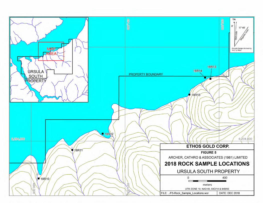
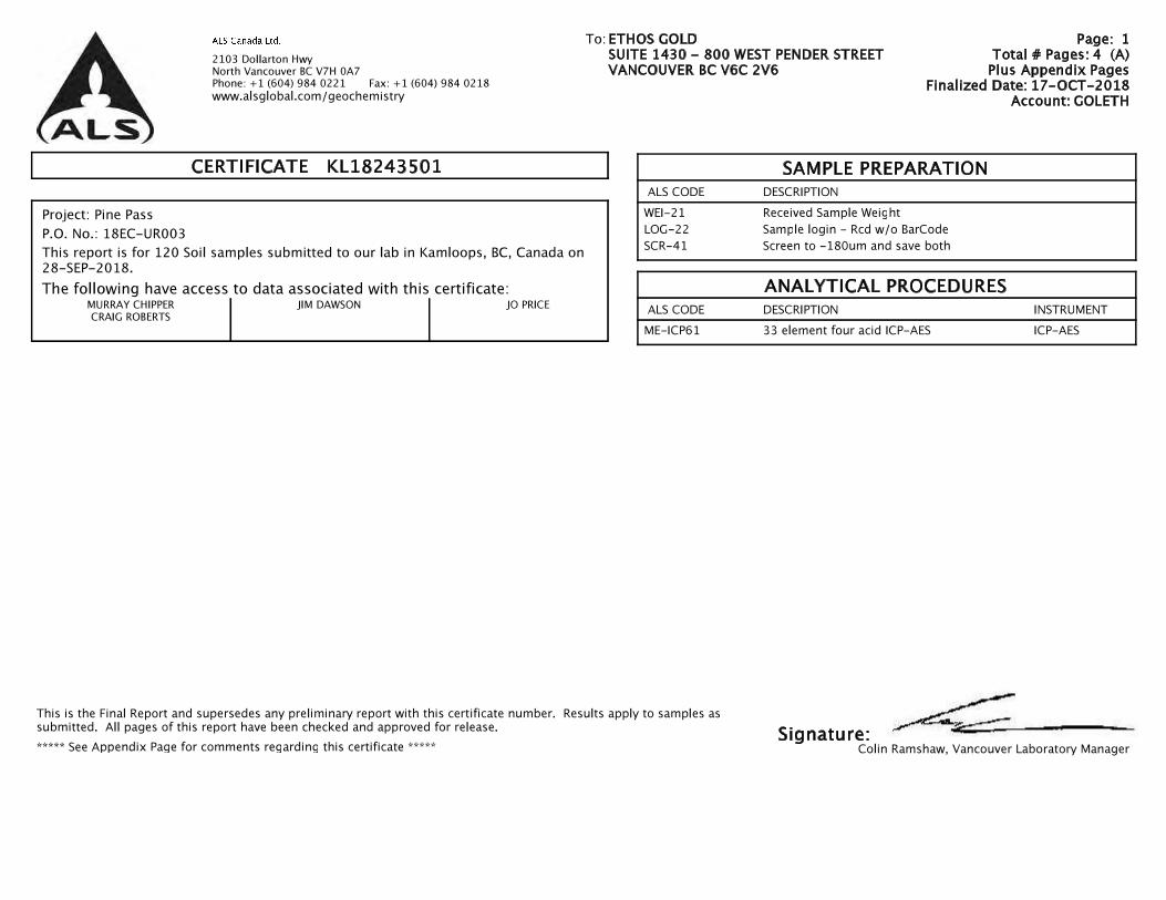
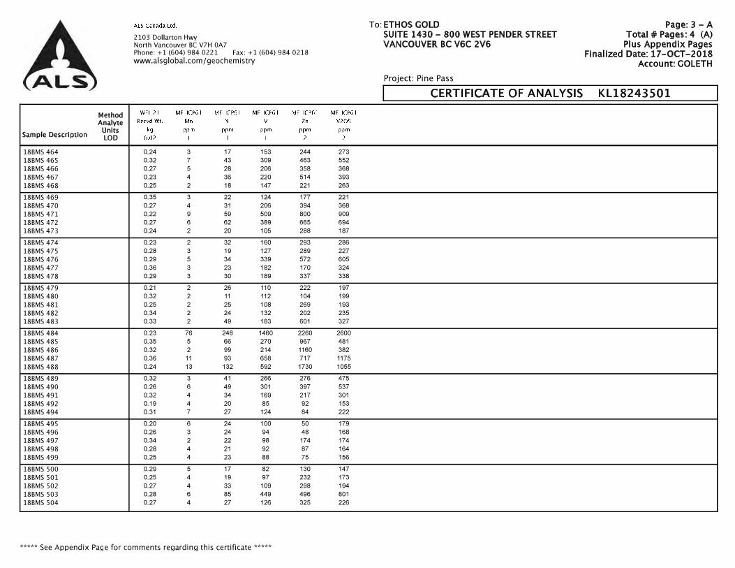
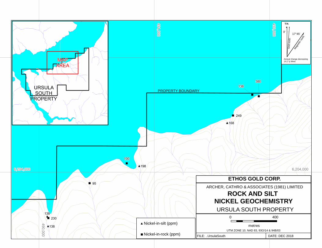
PROPERTY MINERALIZATION The Ursula South property covers phosphatic and vanadiferous Toad Formation shale. In 2018, Ethos Gold collected six rock samples from the northern part of the property, along the south shore of Peace Reach. The 2018 rock sample locations are plotted on Figure 5. Rock Sample Descriptions and Certificates of Analysis for the 2018 samples are provided in Appendices III and IV, respectively. Rock geochemistry is illustrated in Appendix V. Rock geochemical sample sites on the property were marked with orange flagging tape and aluminum tags inscribed with the sample number. The location of each sample was determined using a handheld GPS unit. Rock sample preparation and multi-element analyses were carried out at ALS Minerals laboratories in Kamloops and North Vancouver, BC, respectively. Each

6
Archer, Cathro & Associates (1981) Limited Ursula South Property Assessment Report December 2018
sample was dried and fine crushed to better than 70% passing 2 mm, and then a 250 g split was pulverized to better than 85% passing 75 microns. The fine fraction was analyzed for four elements (molybdenum, nickel, vanadium and zinc) using a four-acid digestion followed by inductively coupled plasma combined with atomic emission spectroscopy (ME-ICP61). In 2018, the strongest vanadium-in-rock values were obtained from sooty, calcareous black shale, hosting disseminated, very fine grained pyrite. The easternmost rock sample, 18R13, yielded 0.51% V2O5, 2500 ppm zinc and 240 ppm molybdenum. Another sample (18R15) collected 280 m to the southwest returned values of 0.34% V2O5, 2000 ppm zinc and 107 ppm molybdenum. Results from the six rock samples are tabulated below.
Table I – 2018 Rock Geochemical Results
Sample V2O5 (%) Zn (ppm) Mo (ppm) Ni (ppm) 18R10 0.263 1050 29 230 18R11 0.1975 637 54 95 18R12 0.249 707 62 100 18R13 0.514 2500 240 380 18R14 0.295 1120 52 138 18R15 0.343 2000 107 249
STREAM SEDIMENT GEOCHEMISTRY
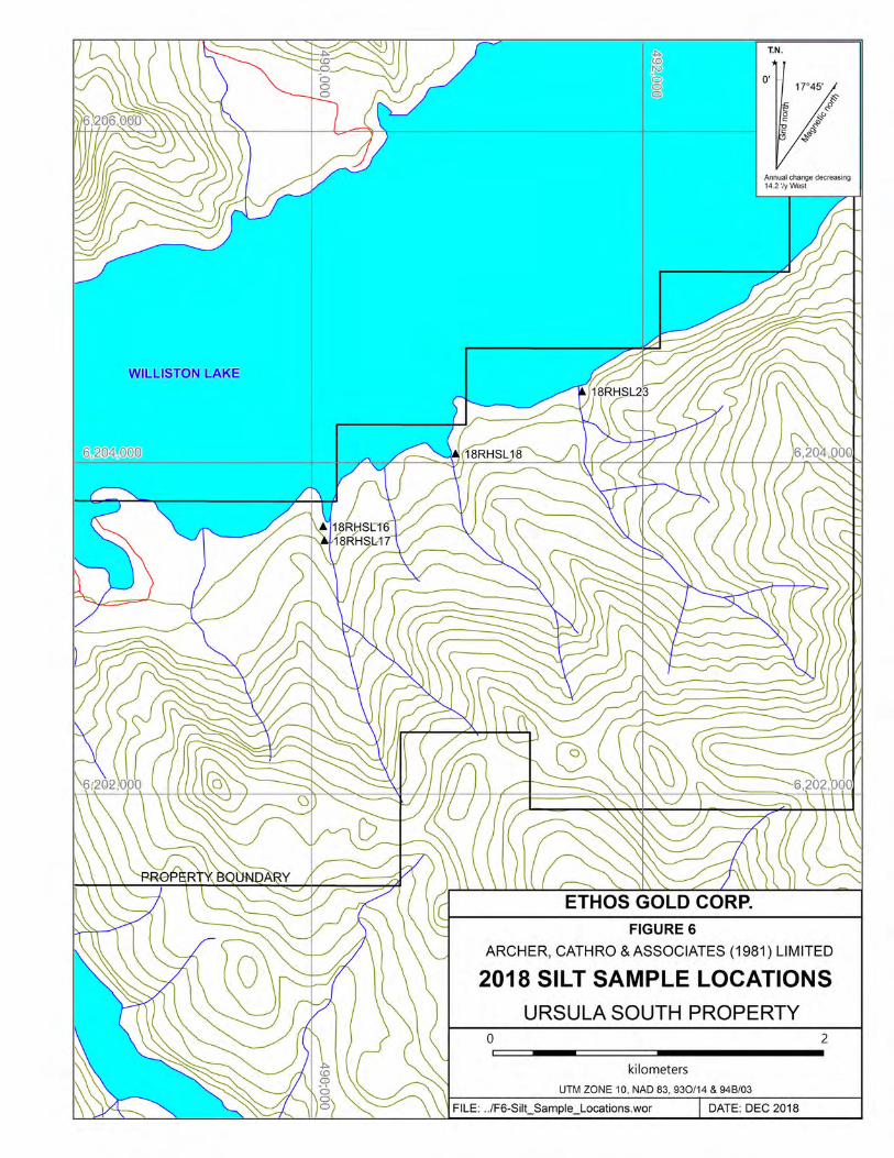
In 2018, a total of four silt samples were collected from the property. The silt sample locations are plotted on Figure 6 and Certificates of Analysis are provided in Appendix IV. Silt sample locations were recorded using hand-held GPS units. Samples were collected using a hand-held auger, and sample sites are marked by orange flagging labelled with the sample number. The silt samples were sent to ALS Minerals in Kamloops, where they were dried and screened to -180 microns. The fine fractions were then shipped to ALS Minerals in North Vancouver where they were analyzed for four elements (molybdenum, nickel, vanadium and zinc) using a four-acid digestion followed by inductively coupled plasma combined with atomic emission spectroscopy (ME-ICP61). Table II below provides the locations of each sample, in NAD83 format, and the geochemical results.
Table II – 2018 Silt Sample Locations and Geochemical Results
Sample Easting Northing V (ppm) Zn (ppm) Mo (ppm) N (ppm) 18RHSL16 490070 6203616 564 1495 26 138 18RHSL17 490078 6203532 589 1485 26 138 18RHSL18 490869 6204055 716 2490 35 198 18RHSL23 491632 6204430 538 1790 19 168
7
Archer, Cathro & Associates (1981) Limited Ursula South Property Assessment Report December 2018
All of the 2018 silt samples were strongly anomalous for vanadium (> 500 ppm) and zinc (> 1000 ppm), with the strongest response from sample 18RHL18, which yielded 716 ppm vanadium and 2490 ppm zinc. None of the samples have received any follow-up work. Silt geochemistry is illustrated in Appendix V.
DISCUSSION AND CONCLUSIONS The Ursula South property is located in the Rocky Mountains of northeastern British Columbia, and covers vanadiferous, Triassic-aged shale. In the property area, middle Triassic sedimentation took place within an anoxic to euxinic basin, with low depositional rates. Black shales formed in this setting are characteristically elevated in reduced sulphur, organic carbon, and a suite of metals that includes vanadium. In 2018, Ethos Gold successfully identified strongly enriched vanadiferous black shale on the property. Rock samples returned up to 0.51% V2O5, 2500 ppm zinc, and 240 ppm molybdenum. Silt sampling, performed concurrently with rock sampling, yielded a vanadium-in-rock value of 716 ppm,from a drainage that has received no follow-up work. Based on the elevated vanadium geochemistry in rock and silt samples, further work on the property is warranted. This work should include contour soil sampling up-slope of the 2018 rock and silt samples. Reconnaissance-scale silt and soil sampling is also recommended, to test for the presence of vanadium outside of these areas. Geological mapping in conjunction with prospecting should be performed across the property. Because the vanadium grades in the shale cannot be visually estimated, the use of a hand-held x-ray fluorescence (XRF) spectrometer, calibrated to detect vanadium, may be helpful in guiding future exploration. Hand trenching, and possibly diamond drilling, is recommended, pending favourable results. Respectfully submitted, ARCHER, CATHRO & ASSOCIATES (1981) LIMITED
J. Morton, B.Sc., P.Geo.
8
Archer, Cathro & Associates (1981) Limited Ursula South Property Assessment Report December 2018
REFERENCES
BC Minfile 2018 Minfile detail report on Wapiti Phosphate (093I 039); BC Geological Survey, Ministry of Energy, Mines & Petroleum Resources. Available at: http://minfile.gov.bc.ca/Summary.aspx?minfilno=093I++039 Butrenchuk, S. 1996 Phosphate deposits in British Columbia; British Columbia Geological Survey, Bulletin 98. Colpron, M. and Nelson, J.L. 2011 A digital atlas of terranes for the northern cordillera; British Columbia Geological Survey, GeoFile 2011-11. deGraff, K., Harper, G. and Manns, F.T. 2016 Report on diamond drilling, outcrop sampling and geology on the Coral Claims; report prepared for Minfocus Exploration Corp.; Assessment report no. 36370. Fertoz Ltd 2017 Fertoz Ltd. annual report for the year ended 30 June, 2017; Available at: https://www.fertoz.com/wp-content/uploads/2017/10/Fertoz-Ltd-2017- Annual-Report_20171030__100-Final.pdf Gibson, D.W. 1975 Triassic rocks of the Rocky Mountain Foothills and Front Ranges of northeastern British Columbia and west-central Alberta; Geological Survey of Canada, Bulletin 247. Jackaman, W. 2008 Regional stream sediment and water geochemical data, Pine Pass (NTS 093O), British Columbia; Geoscience BC, Report 2008-7. Kelley, K.D., Scott, C.T., Polyak, D.E. and Kimball, B.E. 2017 Vanadium; In: Critical mineral resources of the United States – economic and environmental geology and prospects for future supply (eds. Schulz, K.J, DeYoung, J.H., Seal, R.R., II, and Bradley, D.C.); U.S. Geological Survey Professional Paper 1802. McMechan, M.E. 1986 Geology, Point Creek, British Columbia; Geological Survey of Canada, Map 1624A, scale 1:50,000. 1987 Stratigraphy and structure of the Mount Selwyn area, Rocky Mountains, northeastern British Columbia; Geological Survey of Canada, Paper 85-28.

9
Archer, Cathro & Associates (1981) Limited Ursula South Property Assessment Report December 2018
Thompson, R.I. 1987 Geology, Mount Brewster and Jones Peak, British Columbia; Geological Survey of Canada, Map 1-1986, scale 1:50,000. 1989 Stratigraphy, tectonic evolution and structural analysis of the Halfway River map area (94 B), northern Rocky Mountains, British Columbia; Geological Survey of Canada, Memoir 42

Archer, Cathro & Associates (1981) Limited Ursula South Property Assessment Report December 2018
APPENDIX I
STATEMENTS OF QUALIFICATIONS

Archer, Cathro & Associates (1981) Limited Ursula South Property Assessment Report December 2018
STATEMENT OF QUALIFICATIONS I, Jack Morton, with business addresses in Whitehorse, Yukon Territory and Vancouver, British Columbia and residential address in Vancouver, British Columbia, hereby certify that:
1. I graduated from Simon Fraser University in 2013 with a B.Sc. in Earth Science.
2. From 2007 to present, I have been actively engaged in mineral exploration in Yukon Territory, British Columbia, and Northwest Territories.
3. I am a Professional Geologist (P.Geo.) with the Association of Professional Engineers and Geoscientists of British Columbia (License Number 45807).
4. I supervised the field program and have interpreted all data resulting from this work.
J. Morton, B.Sc., P.Geo.

Archer, Cathro & Associates (1981) Limited Ursula South Property Assessment Report December 2018
APPENDIX II
STATEMENT OF COSTS

LabourEmployee Job Description Time Period TotalJack Morton Senior Geologist September 18, to September 23, 2018Rick Henderson Labour Supervisor August 4, 2018 and September 18 to September 23, 2018Brent Meszaros Labourer August 4, 2018 and September 18 to September 23, 2018Eldric Mannsfeldner Labourer August 4, 2018 and September 18 to September 23, 2018Kieren Haward Labourer September 18 to September 21, 2018 and September 23, 2018Brandon Barendregt Labourer September 18 to September 21, 2018 and September 23, 2018Herb Allen Labourer September 18 to September 23, 2018Patrick Butler Labourer September 18 to September 23, 2018Darin Black Labourer September 18 to September 23, 2018Frank Robinson Labourer August 4, 2018
$1,637.76
ExpensesTravel/Lodging Expenses 469.66$ Meals 131.34$ Truck/Ranger/Quad Rentals 188.18$ Fuel 53.49$ Helicopter - Buffalo Aerial Services 2,469.86$ Misc Supplies 66.18$ Assaying 314.04$ Sample Frieght 8.29$ Report Writing 6,528.00$
10,229.06$
Total 2018 expenditures: $11,866.82
Archer, Cathro & Associates (1981) Limited Ursula South Property Assessment Report December 2018
APPENDIX III
ROCK SAMPLE DESCRIPTIONS

Sample Easting Northing Elevation (m) Material Comments Date18R10 490081 6203603 650 OC Very sooty, dark black, calcareous shale, with white precip. on
weathered surfaces.20-Sep-18
18R11 490439 6203906 650 OC Dark grey, sooty and graphitic, limey siltstone, with numerous mm-scale carb. veinlets and gashes throughout, and white precip. on weathered surfaces.
20-Sep-18
18R12 490761 6204079 650 OC Sooty dark grey-black calcareous shale, with trace dissem. very fine grained py. throughout, and rounded vugs, up to 1.5 cm in diameter, surrounded by a 'halo' of orange oxide.
20-Sep-18
18R13 491894 6204706 650 OC Rock with the same lithology as sample 18R10, with trace dissem. very fine grained py. throughout and one cast of a bivalve fossil.
22-Sep-18
18R14 491851 6204676 650 OC Punky weathering rock with the same lithology as sample 18R10. 22-Sep-18
18R15 491684 6204495 650 OC Sooty, calcareous, dark grey-black shale with numerous, rounded, mm-scale vugs with rusty-orange staining as 'halos' surrounding the vugs, and white precip. on weathered surfaces.
22-Sep-18
Archer, Cathro & Associates (1981) Limited Ursula South Property Assessment Report December 2018
APPENDIX IV
CERTIFICATES OF ANALYSIS


SAMPLE PREPARATION
ANALYTICAL PROCEDURES
CERTIFICATE KL18259955
ALS Canada Ltd.
Signature:

ALS Canada Ltd.
CERTIFICATE OF ANALYSIS KL18259955
WEI-21 ME-ICP61 ME-ICP61 ME-ICP61 ME-ICP61 ME-ICP61
Recvd Wt. Mo Ni V Zn V2O5
kg ppm ppm ppm ppm ppm
0.02 1 1 1 2 2

ALS Canada Ltd.
CERTIFICATE OF ANALYSIS KL18259955
CERTIFICATE COMMENTS

Archer, Cathro & Associates (1981) Limited Ursula South Property Assessment Report December 2018
APPENDIX V
ROCK AND SILT GEOCHEMISTRY FIGURES

ARCHER, CATHRO & ASSOCIATES (1981) LIMITED
ROCK AND SILT MOLYBDENUM GEOCHEMISTRY
FILE: ..UrsulaSouth DATE: DEC 2018
URSULA SOUTH PROPERTY
ETHOS GOLD CORP.
UTM ZONE 10, NAD 83, 93O/14 & 94B/03
0 400
metres
T.N.
Grid
nort
h
Mag
netic
nor
th
17°45'0'
Annual change decreasing 14.2 '/y West
PROPERTY BOUNDARY
Molybdenum-in-silt (ppm)
Molybdenum-in-rock (ppm)
ARCHER, CATHRO & ASSOCIATES (1981) LIMITED
ROCK AND SILT NICKEL GEOCHEMISTRY
FILE: ..UrsulaSouth DATE: DEC 2018
URSULA SOUTH PROPERTY
ETHOS GOLD CORP.
UTM ZONE 10, NAD 83, 93O/14 & 94B/03
0 400
metres
T.N.
Grid
nort
h
Mag
netic
nor
th
17°45'0'
Annual change decreasing 14.2 '/y West
PROPERTY BOUNDARY
Nickel-in-silt (ppm)
Nickel-in-rock (ppm)

ARCHER, CATHRO & ASSOCIATES (1981) LIMITED
ROCK AND SILT ZINC GEOCHEMISTRY
FILE: ..UrsulaSouth DATE: DEC 2018
URSULA SOUTH PROPERTY
ETHOS GOLD CORP.
UTM ZONE 10, NAD 83, 93O/14 & 94B/03
0 400
metres
T.N.
Grid
nort
h
Mag
netic
nor
th
17°45'0'
Annual change decreasing 14.2 '/y West
PROPERTY BOUNDARY
Zinc-in-silt (ppm)
Zinc-in-rock (ppm)

ARCHER, CATHRO & ASSOCIATES (1981) LIMITED
ROCK AND SILT VANADIUM GEOCHEMISTRY
FILE: ..UrsulaSouth DATE: DEC 2018
URSULA SOUTH PROPERTY
ETHOS GOLD CORP.
UTM ZONE 10, NAD 83, 93O/14 & 94B/03
0 400
metres
T.N.
Grid
nort
h
Mag
netic
nor
th
17°45'0'
Annual change decreasing 14.2 '/y West
PROPERTY BOUNDARY
Vanadium-in-silt (ppm)
Vanadium-in-rock (ppm)

ARCHER, CATHRO & ASSOCIATES (1981) LIMITED
ROCK AND SILT VANADIUM PENTOXIDE GEOCHEMISTRY
FILE: ..UrsulaSouth DATE: DEC 2018
URSULA SOUTH PROPERTY
ETHOS GOLD CORP.
UTM ZONE 10, NAD 83, 93O/14 & 94B/03
0 400
metres
T.N.
Grid
nort
h
Mag
netic
nor
th
17°45'0'
Annual change decreasing 14.2 '/y West
PROPERTY BOUNDARY
Vanadium pentoxide-in-silt ( )
Vanadium pentoxide-in-rock ( )
%
%