Project Study Document - Walk Bike Marin
40
Miller Creek Road / Las Gallinas Avenue Bicycle and Pedestrian Study Project Study Document By DKS Associates 1970 Broadway, Suite 740 Oakland, CA 94612-2219 (510) 763-2061 October 2011
Transcript of Project Study Document - Walk Bike Marin

Miller Creek Road / Las Gallinas
Avenue Bicycle and Pedestrian Study
Project Study Document
By DKS Associates
1970 Broadway, Suite 740 Oakland, CA 94612-2219 (510) 763-2061
October 2011
Miller Creek Road / Las Gallinas Avenue Bicycle & Pedestrian i October 2011 Project Study Document
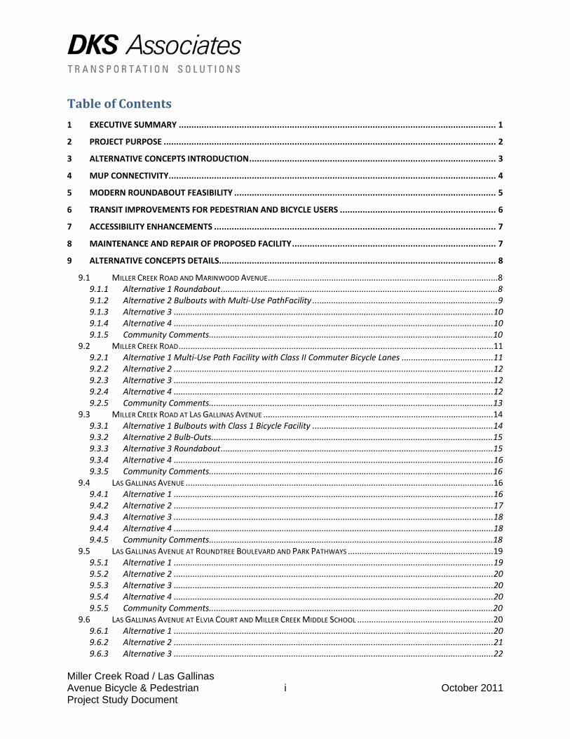
Table of Contents
1 EXECUTIVE SUMMARY .............................................................................................................................. 1 2 PROJECT PURPOSE .................................................................................................................................... 2 3 ALTERNATIVE CONCEPTS INTRODUCTION.................................................................................................. 3 4 MUP CONNECTIVITY.................................................................................................................................. 4 5 MODERN ROUNDABOUT FEASIBILITY ........................................................................................................ 5 6 TRANSIT IMPROVEMENTS FOR PEDESTRIAN AND BICYCLE USERS .............................................................. 6 7 ACCESSIBILITY ENHANCEMENTS ................................................................................................................ 7 8 MAINTENANCE AND REPAIR OF PROPOSED FACILITY................................................................................. 7 9 ALTERNATIVE CONCEPTS DETAILS.............................................................................................................. 8
9.1 MILLER CREEK ROAD AND MARINWOOD AVENUE..................................................................................................8 9.1.1 Alternative 1 Roundabout......................................................................................................................8 9.1.2 Alternative 2 Bulbouts with Multi‐Use PathFacility ...............................................................................9 9.1.3 Alternative 3 ........................................................................................................................................10 9.1.4 Alternative 4 ........................................................................................................................................10 9.1.5 Community Comments.........................................................................................................................10
9.2 MILLER CREEK ROAD......................................................................................................................................11 9.2.1 Alternative 1 Multi‐Use Path Facility with Class II Commuter Bicycle Lanes .......................................11 9.2.2 Alternative 2 ........................................................................................................................................12 9.2.3 Alternative 3 ........................................................................................................................................12 9.2.4 Alternative 4 ........................................................................................................................................12 9.2.5 Community Comments.........................................................................................................................13
9.3 MILLER CREEK ROAD AT LAS GALLINAS AVENUE ..................................................................................................14 9.3.1 Alternative 1 Bulbouts with Class 1 Bicycle Facility .............................................................................14 9.3.2 Alternative 2 Bulb‐Outs........................................................................................................................15 9.3.3 Alternative 3 Roundabout....................................................................................................................15 9.3.4 Alternative 4 ........................................................................................................................................16 9.3.5 Community Comments.........................................................................................................................16
9.4 LAS GALLINAS AVENUE ...................................................................................................................................16 9.4.1 Alternative 1 ........................................................................................................................................16 9.4.2 Alternative 2 ........................................................................................................................................17 9.4.3 Alternative 3 ........................................................................................................................................18 9.4.4 Alternative 4 ........................................................................................................................................18 9.4.5 Community Comments.........................................................................................................................18
9.5 LAS GALLINAS AVENUE AT ROUNDTREE BOULEVARD AND PARK PATHWAYS ..............................................................19 9.5.1 Alternative 1 ........................................................................................................................................19 9.5.2 Alternative 2 ........................................................................................................................................20 9.5.3 Alternative 3 ........................................................................................................................................20 9.5.4 Alternative 4 ........................................................................................................................................20 9.5.5 Community Comments.........................................................................................................................20
9.6 LAS GALLINAS AVENUE AT ELVIA COURT AND MILLER CREEK MIDDLE SCHOOL ..........................................................20 9.6.1 Alternative 1 ........................................................................................................................................20 9.6.2 Alternative 2 ........................................................................................................................................21 9.6.3 Alternative 3 ........................................................................................................................................22
Miller Creek Road / Las Gallinas Avenue Bicycle & Pedestrian ii October 2011 Project Study Document
9.6.4 Alternative 4 ........................................................................................................................................22 9.6.5 Community Comments.........................................................................................................................22
9.7 LAS GALLINAS AVENUE AT ERIN DRIVE (FUTURE ACCESS TO OAKVIEW DEVELOPMENT) ...............................................22 9.7.1 Alternative 1 ........................................................................................................................................22 9.7.2 Alternative 2 ........................................................................................................................................23 9.7.3 Alternative 3 ........................................................................................................................................23 9.7.4 Alternative 4 ........................................................................................................................................23 9.7.5 Community Comments.........................................................................................................................24
9.8 LAS GALLINAS AVENUE AT LUCAS VALLEY ROAD AND TRANSIT STOPS .......................................................................24 9.8.1 Alternative 1 ........................................................................................................................................24 9.8.2 Alternative 2 ........................................................................................................................................24 9.8.3 Alternative 3 ........................................................................................................................................25 9.8.4 Alternative 4 ........................................................................................................................................25 9.8.5 Community Comments.........................................................................................................................25
9.9 LAS GALLINAS AVENUE BETWEEN LUCAS VALLEY ROAD AND CEDAR HILL DRIVE.........................................................25 9.9.1 Alternative 1 ........................................................................................................................................25 9.9.2 Alternative 2 ........................................................................................................................................26 9.9.3 Alternative 3 ........................................................................................................................................26 9.9.4 Alternative 4 ........................................................................................................................................26 9.9.5 Community Comments.........................................................................................................................26
10 COST ESTIMATES......................................................................................................................................27 Appendices Appendix A: Cost Estimate Details Appendix B: Traffic Counts Appendix C: Detailed Plan Alternative 1 Appendix D: Detailed Plan Alternative 2 Appendix E: Detailed Plan Alternative 3 Appendix F: Detailed Plan Alternative 4 Appendix G: Community Member Submitted Design Concepts Appendix H: Existing Conditions Memorandum Appendix I: Traffic Analysis Appendix J: Public Input
Miller Creek Road / Las Gallinas Avenue Bicycle & Pedestrian Study 1 October 2011 Project Study Document
1 Executive Summary This study of Miller Creek Road and Las Gallinas Avenue in unincorporated Marin County identifies a variety of transportation improvement opportunities to enhance bicycle and pedestrian mobility while maintaining vehicular and transit operations within the study area. The study focuses on improving non-motorized mobility to the key land uses in the area including: the Marinwood residential neighborhood, Miller Creek Middle School, Marinwood Shopping Center, Miller Creek Park and future development of Oakview. The recommendations contained in this report strive at developing a balance between the various users, as well as considering the fabric of the neighborhood and environmental concerns. The study area includes Miller Creek Road from Highway 101, (including the freeway bus pads and Pacheco Hill path) to the intersection of Las Gallinas Avenue and along Las Gallinas Avenue between Miller Creek Road and Cedar Hill Drive south of Lucas Valley Road. Included in the study are the bus pads on Lucas Valley Road just east of Las Gallinas Avenue. This study contains an option that a multi-use path (MUP) is feasible to extend the entire length of the study area. Other options include the addition of traffic calming measures including roundabouts along Miller Creek Road at Marinwood Avenue and Las Gallinas Avenue, bulb outs at various locations, elimination of a continuous two way left turn lane along Las Gallinas Avenue, and the elimination of several dedicated left turn pockets to minor streets to calm traffic in the corridor, and improve two way travel off street for bicyclists. The modification of the ramp configuration at the southbound US 101 off ramp to Miller Creek Road is also a reasonable opportunity. The study area consists of two collector streets, namely Las Gallinas Avenue and Miller Creek Road that provide access to regional roadways such as Highway 101 and Lucas Valley Road. The corridor is primarily residential except for some office uses at the intersection of Las Gallinas Avenue and Miller Creek Road, and a gas station and retail uses at the intersection of Marinwood Avenue and Miller Creek Road. Miller Creek Middle School fronts on Las Gallinas Avenue midway between Lucas Valley Road and Miller Creek Road. Miller Creek Park abuts the middle school. One purpose of the project is to reduce the vehicle speeds on the study roadways and to improve pedestrian and bicycle access. Another goal is to improve vehicle drop off circulation around the school. The criteria for the proposed improvements included the following:
• Remain within the public right of way or public lands (no right-of-way acquisition). • Minimize the crossing distance for pedestrians at the intersections. • Respect the existing bus stops and enhance the existing regional stops where
feasible. • Improve the drop off circulation at Miller Creek Middle School. • Interconnect existing and future paths with the MUP where possible. • Recognize that the study area functions as neighborhood streets for the
community as well as being part of the North-South Bikeway, a regional transportation corridor for cyclists and, as a result, there is a wide spectrum of users and abilities.
• Provide ADA compliance for all improvements.

Miller Creek Road / Las Gallinas Avenue Bicycle & Pedestrian Study 2 October 2011 Project Study Document
Capital improvement cost estimates were prepared for the various alternatives. See Section 2 for a summary of each Alternative, and Section 9 and Appendix A for detailed descriptions and cost estimate breakdown. Alternative 1 $5.9 million Alternative 2 $5.0 million Alternative 3 $6.4 million Alternative 4 $0.3 million The above are capital (design and construction) costs. Additional maintenance costs would be incurred for keeping the facilities swept and in good repair. The responsibility for these post-construction costs would need to be further addressed and identified during a future design phase. A variety of concepts were evaluated. For example, along Miller Creek Road, eliminating vehicular traffic from one side of the median roadway and creating a bicycle/pedestrian path on only side of the road and retain the other side for buses and other vehicles was considered. This idea was dismissed because it would impact the residents that front along the one side of Miller Creek Road where the roadway would be removed. Roundabouts were evaluated at two key intersections, namely Miller Creek Road and Las Gallinas Avenue and Miller Creek Road and Marinwood Road which are currently four-way stop controlled with large-radius corners. Alternative routing of bicycles at the roundabout was considered. Transit operations were reviewed and improvements suggested at the regional bus stops. Alternative circulation patterns were studied at the middle school. Also evaluated was the elimination of the two way left turn lane along Las Gallinas Avenue. A low impact bicycle lane striping concept was considered along Miller Creek Road to continue the existing bike lanes on Las Gallinas Avenue and on Miller Creek Road to the west of the study area. This study has determined that there are several improvements that can be implemented to significantly improve the environment for pedestrians and bicyclists.
• A new MUP can physically fit within the road rights of way through the project study area while retaining on-street bike lanes.
• Roundabouts are feasible from a traffic operations perspective. • The elimination of the two way left turn lane on Las Gallinas Avenue will not
result in a drop in Level of Service (LOS) beneath LOS D. • The bulbouts and lane modifications proposed will convey the traffic effectively
while increasing safety for pedestrians and bicyclists. • Transit will be more accessible with the proposed improvements.
The various alternatives evaluated in the study provide a range of options that can be considered as part of future corridor improvements as funding permits. Some improvements, such as adding bulb-outs or reconfiguring intersections, can be done on an individual basis while features such as a multiuse path require that the path be constructed as a single project to avoid discontinuous facilities. Project Purpose A primary focus of the study is to evaluate improvements along the corridor to create a continuous system that would result in a safer and more functional experience for the bicyclists
Miller Creek Road / Las Gallinas Avenue Bicycle & Pedestrian Study 3 October 2011 Project Study Document
and pedestrians that would use the facility. In addition, improvements for access to transit are evaluated to enhance the experience for transit riders. The alternatives concepts take connectivity into consideration. The area is a crossroads of existing and planned regional routes. Connectivity can be achieved by creating a multi-use path that would connect the existing Pacheco Hill Path in the north to the Miller Creek Park path and the planned Oakview path that will extend from the south end of Marinwood Avenue to Lucas Valley Road at Los Gamos Road. Community Outreach A community workshop was held on March 31, 2010 at the Lucas Valley Community Church to present the purpose of the study and solicit public input on initial ideas and concerns. The following summarizes comments made by the public.
• Consider modern roundabouts at the project intersections where they could incorporate traffic calming and be functional for the pedestrians and bicycles.
• Improve the access and parent drop off area in the vicinity of the Miller Creek Middle School
• Limit the loss of on-street parking with any plan proposed • The loss of two way left turn lane on Las Gallinas is acceptable • Provide improved accessibility to the regional transit stops along US 101 and
Lucas Valley Road • Narrow the oversized local intersections to slow traffic and shorten the crossing
distance for pedestrians at the crosswalks. • Provide connectivity with the existing and planned paths that are in the vicinity of
the study area. • Encourage safer bicycle and pedestrian access to Miller Creek Middle School
than under existing conditions. A detailed review of the existing conditions is provided in Appendix H. The second workshop was held on May 24, 2011 with the community at the Dixie School. See Appendix “J” that summarizes comments made by the public.
2 Alternative Concepts Introduction Four Alternative concepts were evaluated as part of this Study. The major components evaluated for this corridor include a new Multi-Use Path (MUP) to connect a gap between the Pacheco Hill Path, the Miller Creek Park Path, an extension of the Miller Creek Path that will be constructed as part of the Oakview residential development project, the Miller Creek Middle School and the City of San Rafael to the south of the study corridor. The Study also evaluates retaining existing Class II bike lanes along Las Gallinas Avenue and adding new Class II bike lanes along Miller Creek Road. Various improvements for bicycle and pedestrian facilities were also evaluated, including bulbouts, new striped crosswalks, accessibility upgrades, improved lighting and pedestrian access at the Miller Creek Road/Highway 101 interchange, traffic circulation improvements at intersections, and bus stop improvements for accessibility and vehicle circulation. Alternative 1 includes:
Miller Creek Road / Las Gallinas Avenue Bicycle & Pedestrian Study 4 October 2011 Project Study Document
A roundabout at the intersection of Miller Creek Road and Marinwood Avenue A continuous 12-15 foot wide multi-use path (MUP) from the Pacheco Hill Path to the
intersection of Cedar Hill Road and Las Gallinas Avenue in San Rafael. Bulbouts at all of the major intersections Eliminate existing two-way, left-turn lane along Las Gallinas Avenue New, on-site school drop off area at Miller Creek Middle School Minor lighting and access improvements at the Miller Creek Road/ US 101 interchange
and a new bicycle rack near the southbound exit ramp A new sidewalk connector at the westbound bus stop near the intersection of Lucas
Valley Road and Las Gallinas Avenue Alternative 2 includes:
Essentially the same improvements along Miller Creek Road between the intersection of Marinwood Avenue and Las Gallinas Avenue, except that bulbouts replace the roundabout at Marinwood Avenue.
Along Las Gallinas Avenue, the left turn lanes are retained at the intersections as currently exists.
The two-way, left-turn lanes are retained by reducing the MUP to 10 feet, the parkway strip to 5 feet, the travel lanes to 11 feet, the bike lanes to 5 feet, and the sidewalk on the east side is reduced to existing conditions, namely 5 feet.
New bulbouts along each of the major intersections along Las Gallinas Avenue from Miller Creek Road to Cedar Hill Drive.
Alternative 2 does not propose any significant changes to the islands at the Lucas Valley Road and Las Gallinas Avenue intersections.
Alternative 3 includes:
A new roundabout at the intersection of Las Gallinas Avenue and Miller Creek Road in lieu of bulbouts.
All other improvements are similar to Alternative 1. However the use of the roundabout is interchangeable with either Alternative 1 or Alternative 2 with minor design changes due to the two-way, left-turn lane configuration associated with Alternative 2.
Alternative 4 includes:
New Class II bicycle lanes and median adjustments on Miller Creek Road between Marinwood Avenue and Las Gallinas Avenue
No changes to Las Gallinas Avenue except for bulbouts near the school. A complete set of Alternative 1-4 plans are included in Appendices C-F. The results of the Traffic Analysis for existing and proposed conditions appear in Appendix I.
3 MUP Connectivity The Multi Use Path considered in Alternatives 1-3 and would extend along the north side of Miller Creek Road from the Miller Creek/US 101 SB interchange ramp to the Las Gallinas Avenue intersection. From this intersection the path extends along the westbound side of Las Gallinas Avenue from Miller Creek Road to Cedar Hill Way. The MUP is intended to be an asphalt pathway. Obstructions should be setback from the MUP by 2-feet. The design of the MUP should be consistent with the current Caltrans Design Manual Section 1000.
Miller Creek Road / Las Gallinas Avenue Bicycle & Pedestrian Study 5 October 2011 Project Study Document
The alignment on the north side of Miller Creek Road and the west side of Las Gallinas Avenue is the preferred side of the street for the following reasons:
• The Pacheco Hill path terminates on the north side of Miller Creek Road just west of the US 101 SB interchange ramp that connects to Miller Creek Road.
• There are fewer driveway conflicts along the north side of Miller Creek Road between Marinwood Avenue and Las Gallinas Avenue.
• Many of the abutting properties on the north side of Miller Creek Road front on other roadways, thereby providing a safer alignment.
• Two important destinations front along the west side of Las Gallinas Avenue – Miller Creek Middle School and Miller Creek Park.
• There are two fewer street crossings on the north side of Miller Creek Road than on the south side.
• The enhancement of having the MUP on the north side of Miller Creek Road and the west side of Las Gallinas Avenue is advantageous because the MUP connects the Pacheco Hill Path near the Miller Creek Road and US 101 ramp area.
• Providing a MUP on the west side of Las Gallinas Avenue will also encourage school children on bicycles coming from San Rafael to use the MUP instead of using the bicycle lane in the opposing direction of Las Gallinas Avenue.
4 Modern Roundabout Feasibility Alternatives 1 and 3 provide two sites where modern roundabouts are feasible: the intersection of Marinwood Avenue and Miller Creek Road; and the intersection of Las Gallinas Avenue and Miller Creek Road. The roundabout was initially evaluated in the Miller Creek Road Operations and Safety Study prepared by Kimley-Horn and Associates dated June 29, 2006. The public expressed a desire for the roundabout to slow traffic down at the intersection of Marinwood Avenue and Miller Creek Road and to hopefully discourage cut through traffic that uses Miller Creek Road as a bypass from US 101 to Lucas Valley Road westbound. Currently the intersection of Marinwood Avenue and Miller Creek Road has four way stop sign control. The previously mentioned operations and safety study identified a modern roundabout as one of the preferred options for improving flow and traffic operations at this intersection. An assessment was made by DKS Associates which demonstrates that a modern roundabout is feasible at the intersection of Marinwood Avenue and Miller Creek Road. This review included the feasibility of the level of service of a single lane, 120’ diameter roundabout at this location. The level of service was calculated to be an acceptable LOS B for a single lane roundabout during the AM Peak Hour. The initial findings of this assessment also revealed that there is sufficient right of way to properly convert this location to a, single-lane roundabout. The proposed design includes the alignment of the MUP and circulation of cyclists and pedestrians through it. A similar assessment and analysis was also prepared for a roundabout at the intersection of Miller Creek Road and Las Gallinas Avenue. This intersection is nearby two schools, Mary F. Silviera Elementary School and Miller Creek Middle School. Mary F. Silviera Elementary School is located on Blackstone Drive approximately ¼ mile north of the intersection of Miller Creek Road and Las Gallinas Avenue. Miller Creek Middle School is located approximately ¼ mile south of the intersection.
Miller Creek Road / Las Gallinas Avenue Bicycle & Pedestrian Study 6 October 2011 Project Study Document
Because vehicles do not generally come to a full stop at a modern roundabout, there may be concern that students crossing at the roundabout could be exposed to different conditions than the all-way stop that exists. However, studies have shown that a modern roundabout improves pedestrian safety for the following reasons:
• Vehicles have a slow entry/circulating/exit speed of 15-20 (or less) Miles Per Hour. This slow speed makes it easier for vehicles to react to pedestrians either in or about to enter a crosswalk.
• At an all-way stop, pedestrians need to be aware of as many of four vehicle approaches simultaneously. At a modern roundabout, the crossing is separated into two stages, so pedestrians only need to be concerned about one or two approaches at a time.
• Splitter islands provide pedestrian refuge during crossing. The islands also shorten the distance that pedestrians are in the street from 70 feetinto two spans of 20 feet each.
• A crossing guard is currently present during school hours at Miller Creek/Las Gallinas to assist in safe passage of students; constructing a roundabout would not necessarily dictate that a crossing guard would no longer be necessary.
Therefore a concept was developed for a roundabout at the Las Gallinas Avenue and Miller Creek Road Intersection. The diameter of the roundabout was designed at 120-feet, which fits within the existing right of way. A single lane roundabout would operate successfully at this location due to the relatively low traffic volume levels, limited right-of-way, and regular presence of larger vehicles (school buses, delivery vehicles etc). For additional information, see the roundabout discussion in Section 8.1.1. On both roundabouts, (Miller Creek Road at Marinwood Avenue and Miller Creek Road at Las Gallinas Avenue) special arrangements were made for cyclists. Since a Multi-Use Path and Class II bike lanes traverse both roundabouts, the concept design provides for two options. The MUP continues through a ten foot wide curb ramp on the perimeter of both roundabouts so that a cyclist may utilize the MUP without entering the roundabout. However, a ramp is provided into the roundabout for cyclists that desire to use the roundabout. Also the Class II bike lanes can use the MUP bypass or continue into the roundabout. See Figure 1 in Section 8.1.1 below.
5 Transit Improvements for Pedestrian and Bicycle Users The public transit that serves the study corridor includes a variety of local and regional lines. At the Miller Creek Road and US 101 Interchange, some of the transit patrons use unmarked on-street parking near the Miller Creek/Marinwood Avenue intersection as an informal park and ride. There are two freeway off ramp stops for the regional buses, one in each direction within the interchange. These stops are connected for pedestrians to Miller Creek Road by walkways and stairs. The southbound stop has a freestanding bus shelter and bicycle rack, plus is illuminated by a single overhead light and a solar powered light in the shelter. The northbound stop is located under the overpass. In order to enhance the transit stop conditions, the following improvements are identified: add pedestrian lighting along the path of travel, provide a bicycle locker/rack system placed in a visible location proximate to Miller Creek Road, and reconstruct of the staircases that connect the Miller Creek Road sidewalk with the pedestrian paths. In addition, the landing area for the northbound stop should be modified so that the cross slope be set at 2% to allow easier boarding for wheelchair users.
Miller Creek Road / Las Gallinas Avenue Bicycle & Pedestrian Study 7 October 2011 Project Study Document
Several Golden Gate and Marin Transit bus routes are in operation along Miller Creek Road. Currently there are four stops in the study corridor along Miller Creek Road. There are two stops on the far side of the intersection along Miller Creek Road and Las Gallinas Avenue. There are two stops that are located on Miller Creek Road west of Marinwood Avenue. The Marinwood Avenue stops have shelters associated with them. The stops near Marinwood Avenue should be upgraded to include bus pullouts as well as sufficient room for passenger loading/shelters and room for wheelchair loading. One reason for the bus pullout is to keep the on-street bicycle lanes separated from stopped buses. No changes are envisioned for the stops near Las Gallinas Avenue. Pedestrian connection improvements to the westbound Lucas Valley Road transit stop have been identified by extending the sidewalk from the corner up to the stop itself. Currently there are inactive transit stops along Las Gallinas Avenue. These stops have been subject to route changes that were implemented by Marin Transit. For purposes of this effort, the Study only focused on the preservation of the stops, but has not considered amenities for these stops. Since parking and the bus stops occupy the same dimension as measured horizontally across the street, this report does not focus on the specific locations for the bus stops. In the future, reactivation of the bus stops should include evaluation of whether the near side or far side of intersection is the preferred location for the stops. The overall design of the bicycle system provides connectivity to transit, an off-street route, plus an on-street facility. This system was selected because the corridor has many residences with driveway access that crosses the MUP. And with the residences fronting on the MUP, it is likely that pedestrians and cyclists will be utilizing the MUP as well. Skilled cyclists are likely to use the on-street system because there are less impediments to deal with. Recreational cyclists are likely to use the MUP because it will have a more secure feel to the recreational rider. When the corridor experiences heavy usage, then the two systems will function well together by providing options for all levels of bicyclists.
6 Accessibility Enhancements The study area is a section of the County that was constructed prior to the adoption of the American Disabilities Act (ADA). Therefore, many of the intersections in the Marinwood community do not have curb ramps. Any new construction would be ADA compliant, including curb ramps and path of travel. Our assessment covered the feasibility of ADA accessibility along the pedestrian path of travel. The alternatives do identify the installation or replacement of curb ramps. This report does not identify any cross slope issues. There may be some driveways that have non-conforming cross slope conditions. These conditions would be addressed by the installation of the new curb gutter, sidewalk and driveways which will be designed in accordance with ADA design standards in effect at the time a project is undertaken.
7 Maintenance and Repair of Proposed Facilities Cost estimates for each Alternative only includes design and capital expenditures for the construction of the project. There is also a responsibility for ongoing maintenance and repair of the additional improvements after construction that is not included in the cost estimates. There
Miller Creek Road / Las Gallinas Avenue Bicycle & Pedestrian Study 8 October 2011 Project Study Document
are a number of ways that the cost for maintenance and repair of these improvements can be provided, whether through the Marinwood Community Services District, which currently maintains the medians in the area, or through creation of a separate assessment district. In all instances, a source of revenue must be identified to cover the costs for maintenance and repair.
8 Alternative Concepts Details A complete set of Alternative 1 Plans are included in Appendix C. A complete set of Alternative 2 Plans are included in Appendix D. The Alternative 3 Plan is included in Appendix E and Alternative 4 Plans are in Appendix F.
8.1 Miller Creek Road and Marinwood Avenue This is a four-legged intersection with stop sign control at each approach. A raised median exists along Miller Creek Road and the two approaches from Marinwood Avenue have left turn pockets. Painted pork chop islands are located at each quadrant and pavement markings that designate crosswalks are located at each approach. Sidewalks and curb ramps are located on each of the four quadrants.
8.1.1 Alternative 1 Roundabout Alternative 1 provides for a single lane roundabout with a diameter of 120-feet. This size is consistent with FHWA guidelines for a standard roundabout. The geometry of the approach roads will have to be modified because a single lane of approach will replace the approaches that have a through/right lane and a separate left turn lane. The crosswalks will be retained at all four approaches; however the location will be adjusted away from the perimeter of the roundabout consistent with good design practice. For the path where the MUP will be placed, the width of the curb ramp will be 10-feet. In addition, an access to and from the roundabout will be made available for cyclists desiring to take the vehicle lane in lieu of the MUP, or accessing the MUP from the roadway to allow access for eastbound cyclists continuing to the northbound Pacheco Hill Path. The median island is proposed to be raised and landscaped. The final design will require modification of the approach roads because the width of the roundabout entrances differs significantly from the existing pavement. The on-street bike lanes terminate at the roundabout because east of the roundabout, the lanes are all shared lanes for bicycles. The bridge cross section is too narrow to accommodate bike lanes. The freeway ramp access heading southbound US 101 presents a formidable challenge for weaving between a bike in a class II lane and the right turn ramp entrance; therefore it is better to have the bikes share the lane. Westbound there are no bike lanes on the bridge and it is too narrow to accommodate anything but a shared lane. The proximity of the proposed MUP at the southbound freeway off ramp provides a reasonable alternative for on street bikes approaching the roundabout and removal of the free-right southbound exit ramp improves the crossing condition for pedestrians by requiring a stop by motorists exiting the freeway.
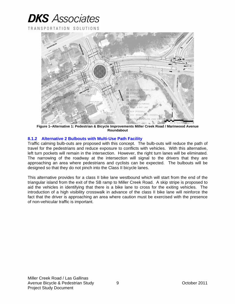
Miller Creek Road / Las Gallinas Avenue Bicycle & Pedestrian Study 9 October 2011 Project Study Document
Figure 1–Alternative 1: Pedestrian & Bicycle Improvements Miller Creek Road / Marinwood Avenue
Roundabout
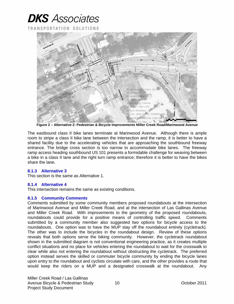
8.1.2 Alternative 2 Bulbouts with Multi-Use Path Facility Traffic calming bulb-outs are proposed with this concept. The bulb-outs will reduce the path of travel for the pedestrians and reduce exposure to conflicts with vehicles. With this alternative, left turn pockets will remain in the intersection. However, the right turn lanes will be eliminated. The narrowing of the roadway at the intersection will signal to the drivers that they are approaching an area where pedestrians and cyclists can be expected. The bulbouts will be designed so that they do not pinch into the Class II bicycle lanes. This alternative provides for a class II bike lane westbound which will start from the end of the triangular island from the exit of the SB ramp to Miller Creek Road. A skip stripe is proposed to aid the vehicles in identifying that there is a bike lane to cross for the exiting vehicles. The introduction of a high visibility crosswalk in advance of the class II bike lane will reinforce the fact that the driver is approaching an area where caution must be exercised with the presence of non-vehicular traffic is important.
Miller Creek Road / Las Gallinas Avenue Bicycle & Pedestrian Study 10 October 2011 Project Study Document
Figure 2 – Alternative 2: Pedestrian & Bicycle Improvements Miller Creek Road/Marinwood Avenue
The eastbound class II bike lanes terminate at Marinwood Avenue. Although there is ample room to stripe a class II bike lane between the intersection and the ramp, it is better to have a shared facility due to the accelerating vehicles that are approaching the southbound freeway entrance. The bridge cross section is too narrow to accommodate bike lanes. The freeway ramp access heading southbound US 101 presents a formidable challenge for weaving between a bike in a class II lane and the right turn ramp entrance; therefore it is better to have the bikes share the lane.
8.1.3 Alternative 3 This section is the same as Alternative 1.
8.1.4 Alternative 4 This intersection remains the same as existing conditions.
8.1.5 Community Comments Comments submitted by some community members proposed roundabouts at the intersection of Marinwood Avenue and Miller Creek Road, and at the intersection of Las Gallinas Avenue and Miller Creek Road. With improvements to the geometry of the proposed roundabouts, roundabouts could provide for a positive means of controlling traffic speed. Comments submitted by a community member also suggested two options for bicycle access to the roundabouts. One option was to have the MUP stay off the roundabout entirely (cycletrack). The other was to include the bicycles in the roundabout design. Review of these options reveals that both options serve the biking community. However, the cycletrack roundabout shown in the submitted diagram is not conventional engineering practice, as it creates multiple conflict situations and no place for vehicles entering the roundabout to wait for the crosswalk to clear while also not entering the roundabout without obstructing the cycletrack. The preferred option instead serves the skilled or commuter bicycle community by ending the bicycle lanes upon entry to the roundabout and cyclists circulate with care, and the other provides a route that would keep the riders on a MUP and a designated crosswalk at the roundabout. Any
Miller Creek Road / Las Gallinas Avenue Bicycle & Pedestrian Study 11 October 2011 Project Study Document
roundabout design should accommodate both types of riders, namely skilled or commuter riders and recreational riders. East of the intersection of Marinwood Avenue and Miller Creek Road, a community member suggested on-street bicycle lanes through the interchange to the northbound ramps on the east side. The bridge across US 101 is too narrow in its current condition to accommodate standard width bicycle lanes. Therefore, placing marked bicycle lanes is not feasible between the northbound and southbound ramps. Additionally, community comments suggested adjustment of the geometry of the southbound exit ramp at Miller Creek Road including the removal of the merge lane. This option was reviewed and is part of the concept included in Alternative 1. However, the right turn movements at the ramp intersection warrant a separate, dedicated turning lane to avoid the potential of queuing onto US 101 during peak periods. The comments submitted by some community members also proposed a twelve-foot wide promenade along the easterly side of Marinwood Avenue south of Miller Creek Road. This area could be constructed in conjunction with future improvements for the Marinwood Village project. Wider sidewalks may be appropriate for this area to support higher-density housing and/or commercial use of this area.
8.2 Miller Creek Road
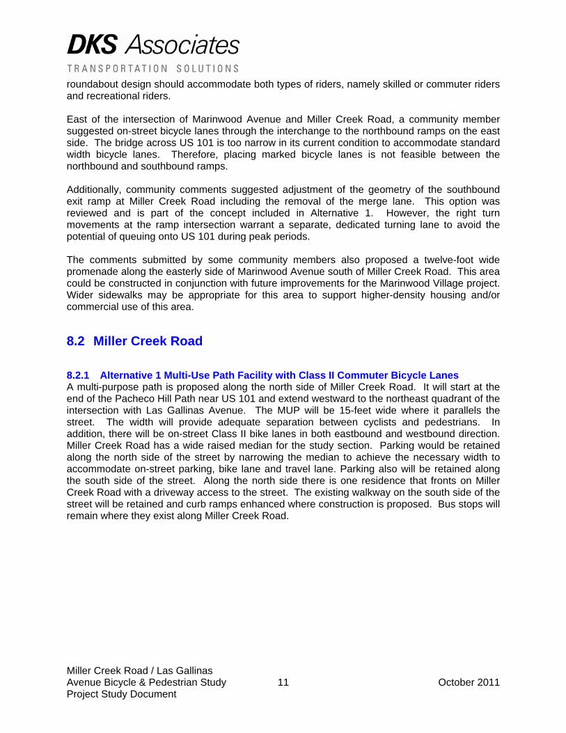
8.2.1 Alternative 1 Multi-Use Path Facility with Class II Commuter Bicycle Lanes A multi-purpose path is proposed along the north side of Miller Creek Road. It will start at the end of the Pacheco Hill Path near US 101 and extend westward to the northeast quadrant of the intersection with Las Gallinas Avenue. The MUP will be 15-feet wide where it parallels the street. The width will provide adequate separation between cyclists and pedestrians. In addition, there will be on-street Class II bike lanes in both eastbound and westbound direction. Miller Creek Road has a wide raised median for the study section. Parking would be retained along the north side of the street by narrowing the median to achieve the necessary width to accommodate on-street parking, bike lane and travel lane. Parking also will be retained along the south side of the street. Along the north side there is one residence that fronts on Miller Creek Road with a driveway access to the street. The existing walkway on the south side of the street will be retained and curb ramps enhanced where construction is proposed. Bus stops will remain where they exist along Miller Creek Road.
Miller Creek Road / Las Gallinas Avenue Bicycle & Pedestrian Study 12 October 2011 Project Study Document
Figure 3–Alternative 1: Pedestrian & Bicycle Improvements along Miller Creek Road East of Las Gallinas
Avenue
8.2.2 Alternative 2 This segment is the same as Alternative 1
8.2.3 Alternative 3 This segment is the same as Alternative 1
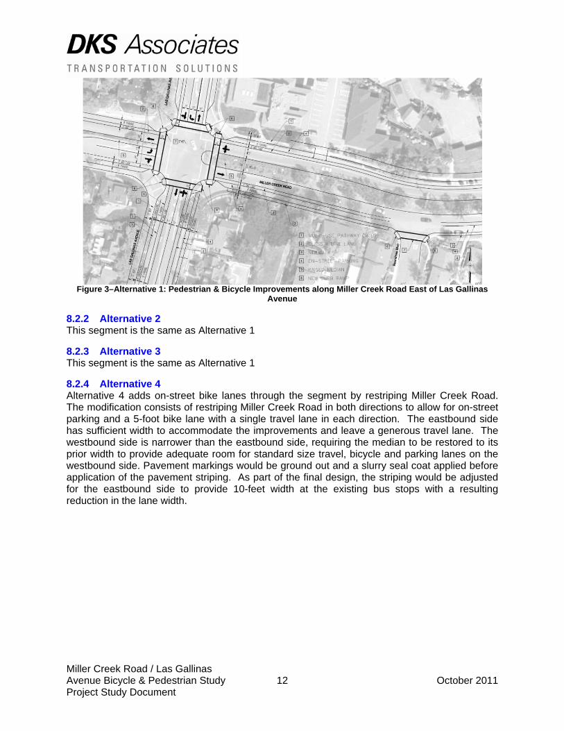
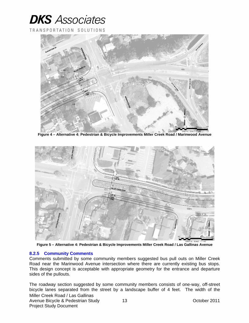
8.2.4 Alternative 4 Alternative 4 adds on-street bike lanes through the segment by restriping Miller Creek Road. The modification consists of restriping Miller Creek Road in both directions to allow for on-street parking and a 5-foot bike lane with a single travel lane in each direction. The eastbound side has sufficient width to accommodate the improvements and leave a generous travel lane. The westbound side is narrower than the eastbound side, requiring the median to be restored to its prior width to provide adequate room for standard size travel, bicycle and parking lanes on the westbound side. Pavement markings would be ground out and a slurry seal coat applied before application of the pavement striping. As part of the final design, the striping would be adjusted for the eastbound side to provide 10-feet width at the existing bus stops with a resulting reduction in the lane width.
Miller Creek Road / Las Gallinas Avenue Bicycle & Pedestrian Study 13 October 2011 Project Study Document
Figure 4 – Alternative 4: Pedestrian & Bicycle Improvements Miller Creek Road / Marinwood Avenue
Figure 5 – Alternative 4: Pedestrian & Bicycle Improvements Miller Creek Road / Las Gallinas Avenue
8.2.5 Community Comments Comments submitted by some community members suggested bus pull outs on Miller Creek Road near the Marinwood Avenue intersection where there are currently existing bus stops. This design concept is acceptable with appropriate geometry for the entrance and departure sides of the pullouts. The roadway section suggested by some community members consists of one-way, off-street bicycle lanes separated from the street by a landscape buffer of 4 feet. The width of the
Miller Creek Road / Las Gallinas Avenue Bicycle & Pedestrian Study 14 October 2011 Project Study Document
facilities is 7 feet in the westerly direction and 6 feet in the easterly direction. Sidewalks abut the paths. Parking is provided in both directions, resulting in a narrowing of the median on the westbound side and a widening of the median by 1-foot on the eastbound side. The cross section suggests that the bike path be set at a different height than the sidewalk. Design and engineering concerns with the plan include the potential for bike riders in this segment to disregard directional flow of the adjoining lanes and that the narrow, one-way bike paths may lead to collisions and user conflicts on the facility. A two-way multi-use path is a preferred design solution where the level of the surface is the same across the entire surface, affording a margin of safety to all users. Pavement markings could be added to the widened MUP that provide some form of allocation of the use of the pavement for bikes and pedestrians. In addition, long term maintenance costs of the community-member suggested design would be substantially higher because either the bike path would need to be swept or cleared of debris by hand or necessitate acquisition of specialized sweeping equipment.
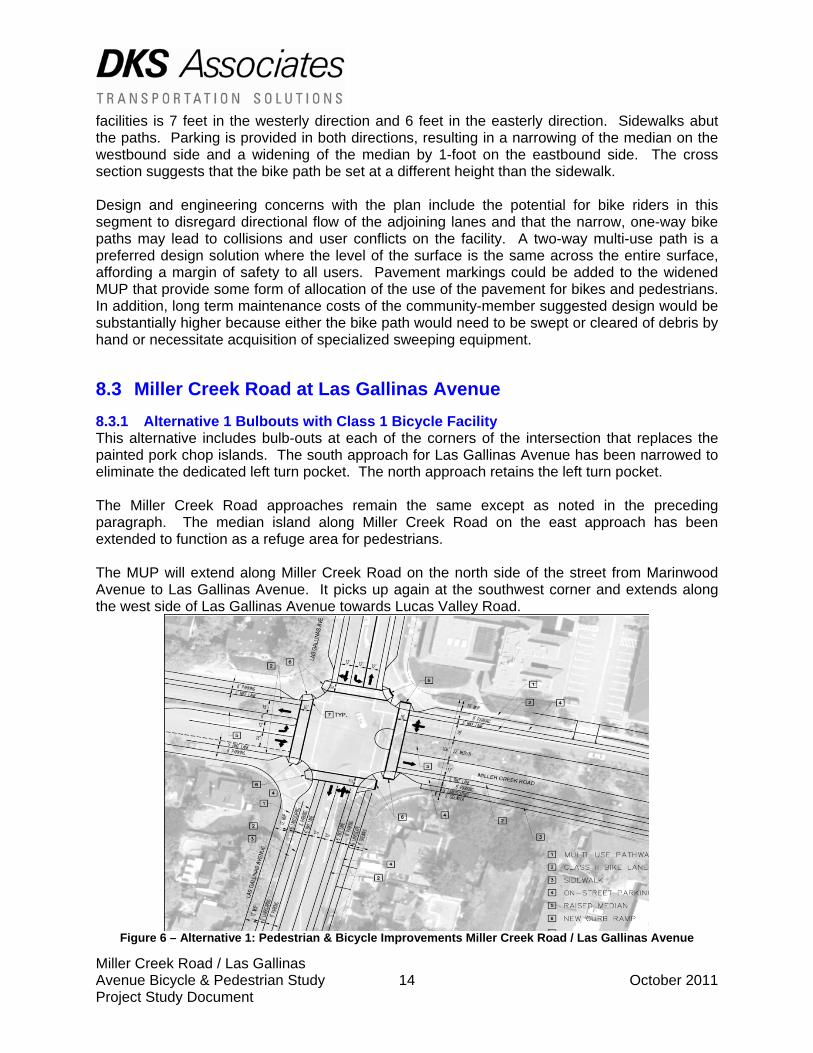
8.3 Miller Creek Road at Las Gallinas Avenue 8.3.1 Alternative 1 Bulbouts with Class 1 Bicycle Facility This alternative includes bulb-outs at each of the corners of the intersection that replaces the painted pork chop islands. The south approach for Las Gallinas Avenue has been narrowed to eliminate the dedicated left turn pocket. The north approach retains the left turn pocket. The Miller Creek Road approaches remain the same except as noted in the preceding paragraph. The median island along Miller Creek Road on the east approach has been extended to function as a refuge area for pedestrians. The MUP will extend along Miller Creek Road on the north side of the street from Marinwood Avenue to Las Gallinas Avenue. It picks up again at the southwest corner and extends along the west side of Las Gallinas Avenue towards Lucas Valley Road.
Figure 6 – Alternative 1: Pedestrian & Bicycle Improvements Miller Creek Road / Las Gallinas Avenue
Miller Creek Road / Las Gallinas Avenue Bicycle & Pedestrian Study 15 October 2011 Project Study Document
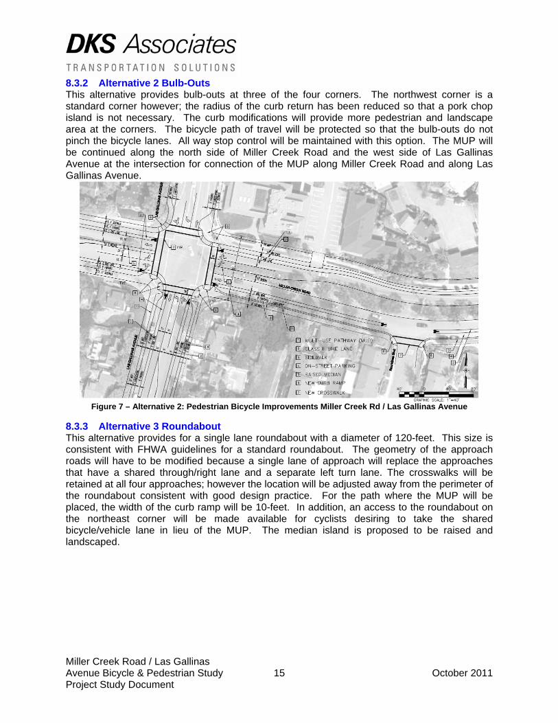
8.3.2 Alternative 2 Bulb-Outs This alternative provides bulb-outs at three of the four corners. The northwest corner is a standard corner however; the radius of the curb return has been reduced so that a pork chop island is not necessary. The curb modifications will provide more pedestrian and landscape area at the corners. The bicycle path of travel will be protected so that the bulb-outs do not pinch the bicycle lanes. All way stop control will be maintained with this option. The MUP will be continued along the north side of Miller Creek Road and the west side of Las Gallinas Avenue at the intersection for connection of the MUP along Miller Creek Road and along Las Gallinas Avenue.
Figure 7 – Alternative 2: Pedestrian Bicycle Improvements Miller Creek Rd / Las Gallinas Avenue
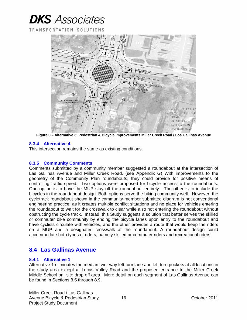
8.3.3 Alternative 3 Roundabout This alternative provides for a single lane roundabout with a diameter of 120-feet. This size is consistent with FHWA guidelines for a standard roundabout. The geometry of the approach roads will have to be modified because a single lane of approach will replace the approaches that have a shared through/right lane and a separate left turn lane. The crosswalks will be retained at all four approaches; however the location will be adjusted away from the perimeter of the roundabout consistent with good design practice. For the path where the MUP will be placed, the width of the curb ramp will be 10-feet. In addition, an access to the roundabout on the northeast corner will be made available for cyclists desiring to take the shared bicycle/vehicle lane in lieu of the MUP. The median island is proposed to be raised and landscaped.
Miller Creek Road / Las Gallinas Avenue Bicycle & Pedestrian Study 16 October 2011 Project Study Document
Figure 8 – Alternative 3: Pedestrian & Bicycle Improvements Miller Creek Road / Los Gallinas Avenue
8.3.4 Alternative 4 This intersection remains the same as existing conditions.
8.3.5 Community Comments Comments submitted by a community member suggested a roundabout at the intersection of Las Gallinas Avenue and Miller Creek Road. (see Appendix G) With improvements to the geometry of the Community Plan roundabouts, they could provide for positive means of controlling traffic speed. Two options were proposed for bicycle access to the roundabouts. One option is to have the MUP stay off the roundabout entirely. The other is to include the bicycles in the roundabout design. Both options serve the biking community well. However, the cycletrack roundabout shown in the community-member submitted diagram is not conventional engineering practice, as it creates multiple conflict situations and no place for vehicles entering the roundabout to wait for the crosswalk to clear while also not entering the roundabout without obstructing the cycle track. Instead, this Study suggests a solution that better serves the skilled or commuter bike community by ending the bicycle lanes upon entry to the roundabout and have cyclists circulate with vehicles, and the other provides a route that would keep the riders on a MUP and a designated crosswalk at the roundabout. A roundabout design could accommodate both types of riders, namely skilled or commuter riders and recreational riders.
8.4 Las Gallinas Avenue 8.4.1 Alternative 1 Alternative 1 eliminates the median two -way left turn lane and left turn pockets at all locations in the study area except at Lucas Valley Road and the proposed entrance to the Miller Creek Middle School on- site drop off area. More detail on each segment of Las Gallinas Avenue can be found in Sections 8.5 through 8.9.
Miller Creek Road / Las Gallinas Avenue Bicycle & Pedestrian Study 17 October 2011 Project Study Document
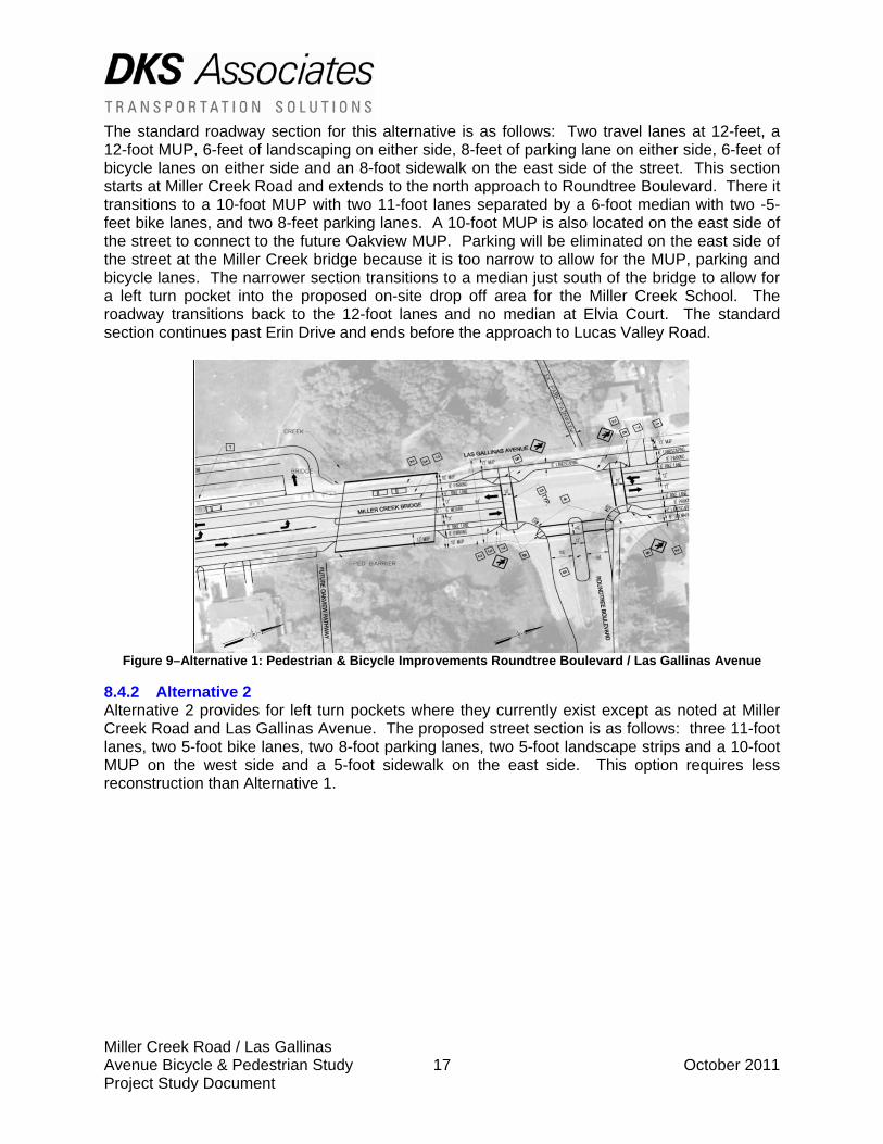
The standard roadway section for this alternative is as follows: Two travel lanes at 12-feet, a 12-foot MUP, 6-feet of landscaping on either side, 8-feet of parking lane on either side, 6-feet of bicycle lanes on either side and an 8-foot sidewalk on the east side of the street. This section starts at Miller Creek Road and extends to the north approach to Roundtree Boulevard. There it transitions to a 10-foot MUP with two 11-foot lanes separated by a 6-foot median with two -5-feet bike lanes, and two 8-feet parking lanes. A 10-foot MUP is also located on the east side of the street to connect to the future Oakview MUP. Parking will be eliminated on the east side of the street at the Miller Creek bridge because it is too narrow to allow for the MUP, parking and bicycle lanes. The narrower section transitions to a median just south of the bridge to allow for a left turn pocket into the proposed on-site drop off area for the Miller Creek School. The roadway transitions back to the 12-foot lanes and no median at Elvia Court. The standard section continues past Erin Drive and ends before the approach to Lucas Valley Road.
Figure 9–Alternative 1: Pedestrian & Bicycle Improvements Roundtree Boulevard / Las Gallinas Avenue
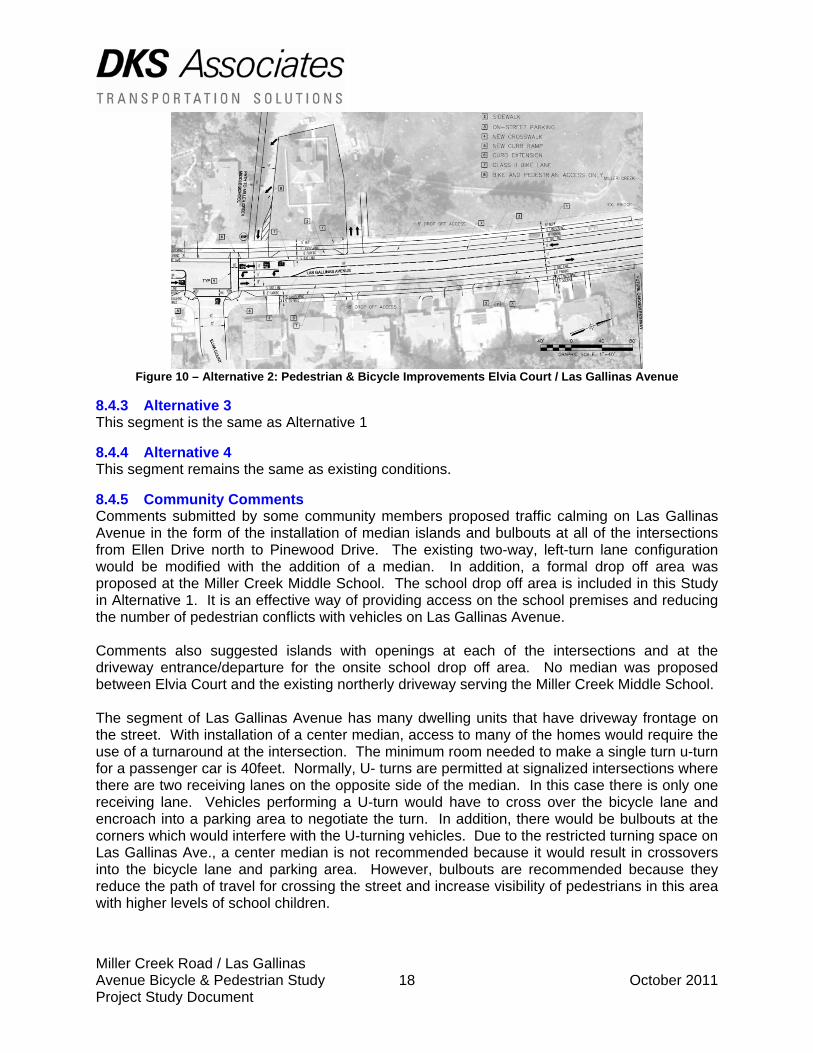
8.4.2 Alternative 2 Alternative 2 provides for left turn pockets where they currently exist except as noted at Miller Creek Road and Las Gallinas Avenue. The proposed street section is as follows: three 11-foot lanes, two 5-foot bike lanes, two 8-foot parking lanes, two 5-foot landscape strips and a 10-foot MUP on the west side and a 5-foot sidewalk on the east side. This option requires less reconstruction than Alternative 1.
Miller Creek Road / Las Gallinas Avenue Bicycle & Pedestrian Study 18 October 2011 Project Study Document
Figure 10 – Alternative 2: Pedestrian & Bicycle Improvements Elvia Court / Las Gallinas Avenue
8.4.3 Alternative 3 This segment is the same as Alternative 1
8.4.4 Alternative 4 This segment remains the same as existing conditions.
8.4.5 Community Comments Comments submitted by some community members proposed traffic calming on Las Gallinas Avenue in the form of the installation of median islands and bulbouts at all of the intersections from Ellen Drive north to Pinewood Drive. The existing two-way, left-turn lane configuration would be modified with the addition of a median. In addition, a formal drop off area was proposed at the Miller Creek Middle School. The school drop off area is included in this Study in Alternative 1. It is an effective way of providing access on the school premises and reducing the number of pedestrian conflicts with vehicles on Las Gallinas Avenue. Comments also suggested islands with openings at each of the intersections and at the driveway entrance/departure for the onsite school drop off area. No median was proposed between Elvia Court and the existing northerly driveway serving the Miller Creek Middle School. The segment of Las Gallinas Avenue has many dwelling units that have driveway frontage on the street. With installation of a center median, access to many of the homes would require the use of a turnaround at the intersection. The minimum room needed to make a single turn u-turn for a passenger car is 40feet. Normally, U- turns are permitted at signalized intersections where there are two receiving lanes on the opposite side of the median. In this case there is only one receiving lane. Vehicles performing a U-turn would have to cross over the bicycle lane and encroach into a parking area to negotiate the turn. In addition, there would be bulbouts at the corners which would interfere with the U-turning vehicles. Due to the restricted turning space on Las Gallinas Ave., a center median is not recommended because it would result in crossovers into the bicycle lane and parking area. However, bulbouts are recommended because they reduce the path of travel for crossing the street and increase visibility of pedestrians in this area with higher levels of school children.
Miller Creek Road / Las Gallinas Avenue Bicycle & Pedestrian Study 19 October 2011 Project Study Document
Comments submitted by some community members also proposed a speed table between Elvia Court and the southernmost driveway access to the Miller Creek School. Las Gallinas Avenue functions as a collector roadway connecting Marinwood Estates to the north with Manuel T Frietas Parkway to the south and regional commercial shopping further south. Current speed limit on Las Gallinas Avenue is posted at 25-miles per hour. At Miller Creek Middle School, there is an all way stop at the intersection of Elvia Court and Las Gallinas Avenue. The volume of traffic on Las Gallinas Avenue is approximately 4,000 vehicles per day. According to the ITE Guidelines for the Design and Installation of Speed Humps, speed humps should be considered after all other means of traffic control have been tried. It further states that speed humps are appropriate for local residential streets that have a maximum volume of 3,000 vehicles per day on a two lane road. The two way daily traffic flow on Las Gallinas Avenue based upon traffic counts taken by DKS Associates exceeds the 3,000 vehicles per day threshold. Therefore, speed humps or raised pavement crosswalks are not recommended for this area.
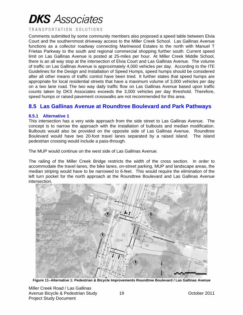
8.5 Las Gallinas Avenue at Roundtree Boulevard and Park Pathways 8.5.1 Alternative 1 This intersection has a very wide approach from the side street to Las Gallinas Avenue. The concept is to narrow the approach with the installation of bulbouts and median modification. Bulbouts would also be provided on the opposite side of Las Gallinas Avenue. Roundtree Boulevard would have two 20-foot travel lanes separated by a raised island. The island pedestrian crossing would include a pass-through. The MUP would continue on the west side of Las Gallinas Avenue. The railing of the Miller Creek Bridge restricts the width of the cross section. In order to accommodate the travel lanes, the bike lanes, on-street parking, MUP and landscape areas, the median striping would have to be narrowed to 6-feet. This would require the elimination of the left turn pocket for the north approach at the Roundtree Boulevard and Las Gallinas Avenue intersection.
Figure 11–Alternative 1: Pedestrian & Bicycle Improvements Roundtree Boulevard / Las Gallinas Avenue
Miller Creek Road / Las Gallinas Avenue Bicycle & Pedestrian Study 20 October 2011 Project Study Document
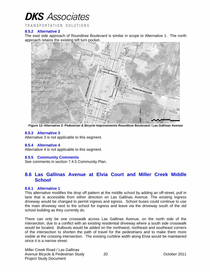
8.5.2 Alternative 2 The east side approach of Roundtree Boulevard is similar in scope to Alternative 1. The north approach retains the existing left turn pocket.
Figure 12–Alternative 2: Pedestrian & Bicycle Improvements Roundtree Boulevard / Las Gallinas Avenue
8.5.3 Alternative 3 Alternative 3 is not applicable to this segment.
8.5.4 Alternative 4 Alternative 4 is not applicable to this segment.
8.5.5 Community Comments See comments in section 7.4.5 Community Plan.
8.6 Las Gallinas Avenue at Elvia Court and Miller Creek Middle School
8.6.1 Alternative 1 This alternative modifies the drop off pattern at the middle school by adding an off-street, pull in lane that is accessible from either direction on Las Gallinas Avenue. The existing ingress driveway would be changed to permit ingress and egress. School buses could continue to use the main driveway next to the school for ingress and leave via the driveway south of the old school building as they currently do. There can only be one crosswalk across Las Gallinas Avenue, on the north side of the intersection, due to a conflict with an existing residential driveway where a south side crosswalk would be located. Bulbouts would be added on the northwest, northeast and southeast corners of the intersection to shorten the path of travel for the pedestrians and to make them more visible at the crossing intersection. The existing curbline width along Elvia would be maintained since it is a narrow street.
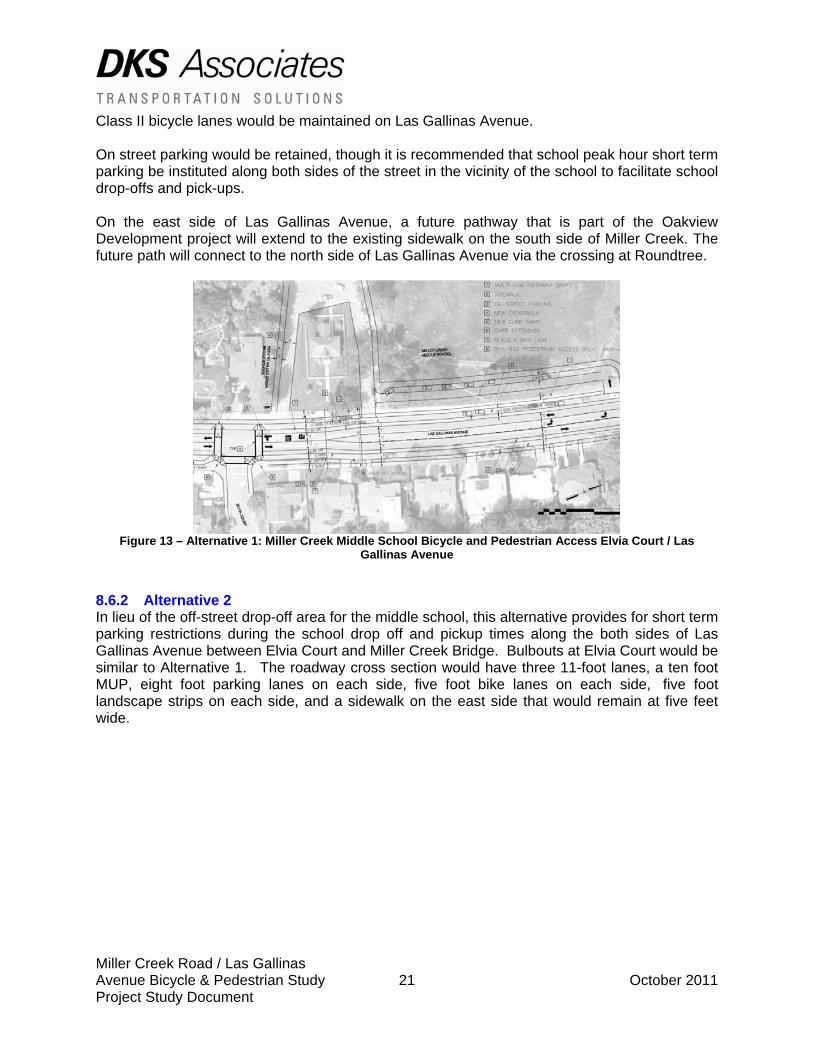
Miller Creek Road / Las Gallinas Avenue Bicycle & Pedestrian Study 21 October 2011 Project Study Document
Class II bicycle lanes would be maintained on Las Gallinas Avenue. On street parking would be retained, though it is recommended that school peak hour short term parking be instituted along both sides of the street in the vicinity of the school to facilitate school drop-offs and pick-ups. On the east side of Las Gallinas Avenue, a future pathway that is part of the Oakview Development project will extend to the existing sidewalk on the south side of Miller Creek. The future path will connect to the north side of Las Gallinas Avenue via the crossing at Roundtree.
Figure 13 – Alternative 1: Miller Creek Middle School Bicycle and Pedestrian Access Elvia Court / Las
Gallinas Avenue
8.6.2 Alternative 2 In lieu of the off-street drop-off area for the middle school, this alternative provides for short term parking restrictions during the school drop off and pickup times along the both sides of Las Gallinas Avenue between Elvia Court and Miller Creek Bridge. Bulbouts at Elvia Court would be similar to Alternative 1. The roadway cross section would have three 11-foot lanes, a ten foot MUP, eight foot parking lanes on each side, five foot bike lanes on each side, five foot landscape strips on each side, and a sidewalk on the east side that would remain at five feet wide.
Miller Creek Road / Las Gallinas Avenue Bicycle & Pedestrian Study 22 October 2011 Project Study Document
Figure 14 – Alternative 2: Pedestrian & Bicycle Improvements Elvia Court / Las Gallinas Avenue
8.6.3 Alternative 3 Alternative 3 is not applicable to this segment.
8.6.4 Alternative 4 Alternative 4 is not applicable to this segment.
8.6.5 Community Comments See discussion in Las Gallinas Avenue Community Comments Section.
8.7 Las Gallinas Avenue at Erin Drive (Future access to Oakview Development)
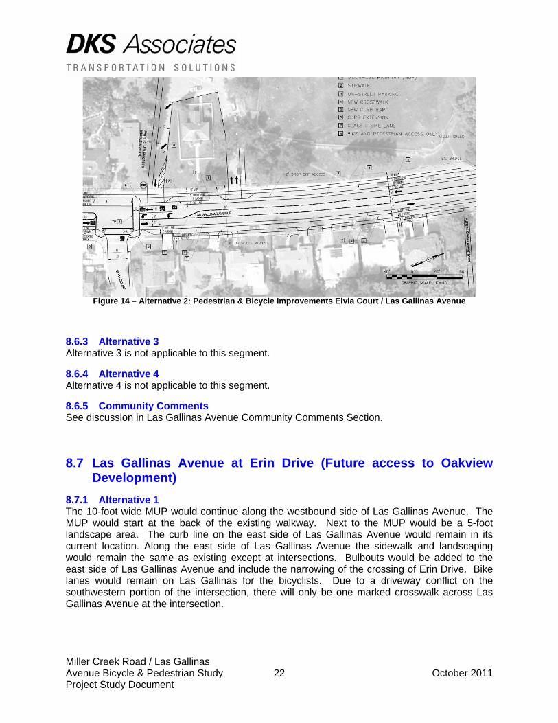
8.7.1 Alternative 1 The 10-foot wide MUP would continue along the westbound side of Las Gallinas Avenue. The MUP would start at the back of the existing walkway. Next to the MUP would be a 5-foot landscape area. The curb line on the east side of Las Gallinas Avenue would remain in its current location. Along the east side of Las Gallinas Avenue the sidewalk and landscaping would remain the same as existing except at intersections. Bulbouts would be added to the east side of Las Gallinas Avenue and include the narrowing of the crossing of Erin Drive. Bike lanes would remain on Las Gallinas for the bicyclists. Due to a driveway conflict on the southwestern portion of the intersection, there will only be one marked crosswalk across Las Gallinas Avenue at the intersection.
Miller Creek Road / Las Gallinas Avenue Bicycle & Pedestrian Study 23 October 2011 Project Study Document
Figure 15 – Alternative 1: Dedicated Left Turn Lane and Crosswalk Erin Drive / Las Gallinas Avenue
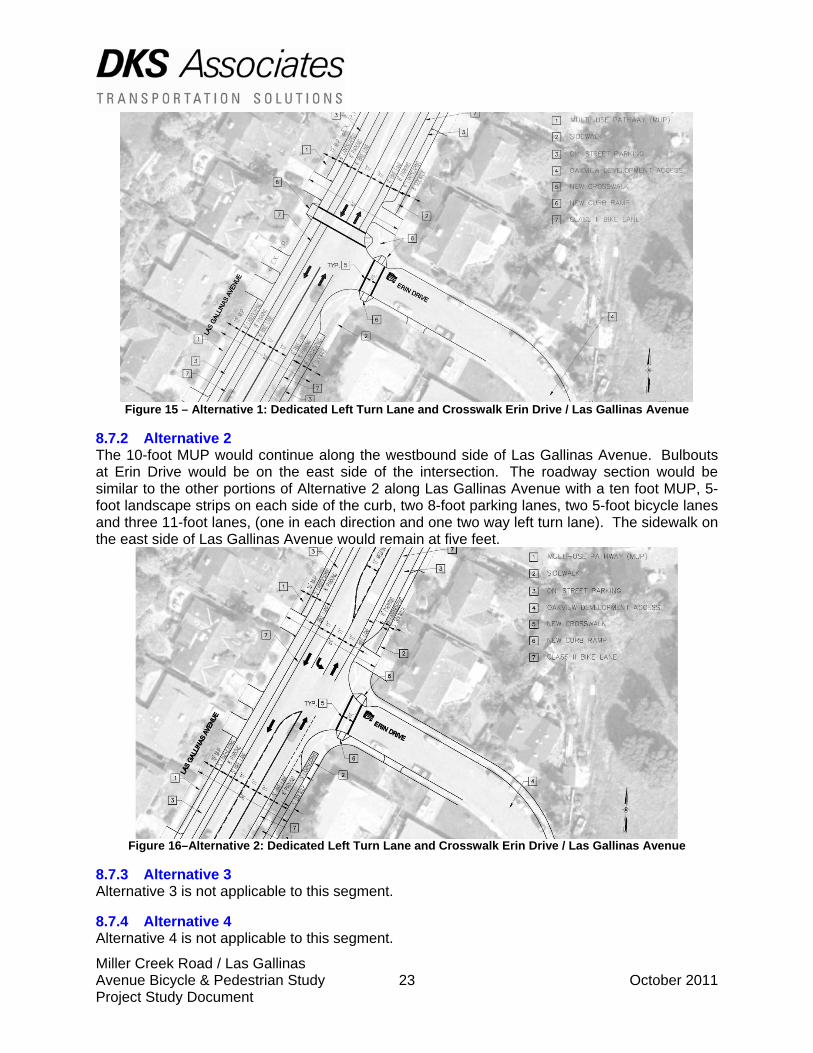
8.7.2 Alternative 2 The 10-foot MUP would continue along the westbound side of Las Gallinas Avenue. Bulbouts at Erin Drive would be on the east side of the intersection. The roadway section would be similar to the other portions of Alternative 2 along Las Gallinas Avenue with a ten foot MUP, 5-foot landscape strips on each side of the curb, two 8-foot parking lanes, two 5-foot bicycle lanes and three 11-foot lanes, (one in each direction and one two way left turn lane). The sidewalk on the east side of Las Gallinas Avenue would remain at five feet.
Figure 16–Alternative 2: Dedicated Left Turn Lane and Crosswalk Erin Drive / Las Gallinas Avenue
8.7.3 Alternative 3 Alternative 3 is not applicable to this segment.
8.7.4 Alternative 4 Alternative 4 is not applicable to this segment.
Miller Creek Road / Las Gallinas Avenue Bicycle & Pedestrian Study 24 October 2011 Project Study Document
8.7.5 Community Comments See Community Comments discussion in Las Gallinas Avenue.
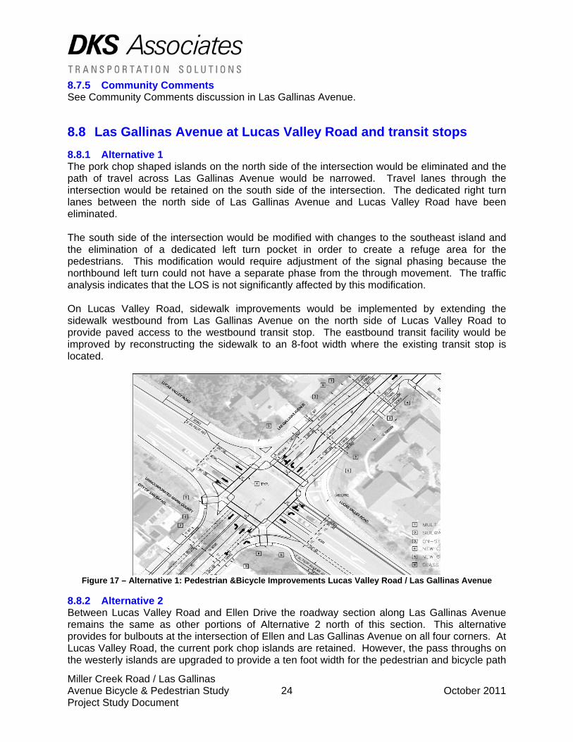
8.8 Las Gallinas Avenue at Lucas Valley Road and transit stops 8.8.1 Alternative 1 The pork chop shaped islands on the north side of the intersection would be eliminated and the path of travel across Las Gallinas Avenue would be narrowed. Travel lanes through the intersection would be retained on the south side of the intersection. The dedicated right turn lanes between the north side of Las Gallinas Avenue and Lucas Valley Road have been eliminated. The south side of the intersection would be modified with changes to the southeast island and the elimination of a dedicated left turn pocket in order to create a refuge area for the pedestrians. This modification would require adjustment of the signal phasing because the northbound left turn could not have a separate phase from the through movement. The traffic analysis indicates that the LOS is not significantly affected by this modification. On Lucas Valley Road, sidewalk improvements would be implemented by extending the sidewalk westbound from Las Gallinas Avenue on the north side of Lucas Valley Road to provide paved access to the westbound transit stop. The eastbound transit facility would be improved by reconstructing the sidewalk to an 8-foot width where the existing transit stop is located.
Figure 17 – Alternative 1: Pedestrian &Bicycle Improvements Lucas Valley Road / Las Gallinas Avenue
8.8.2 Alternative 2 Between Lucas Valley Road and Ellen Drive the roadway section along Las Gallinas Avenue remains the same as other portions of Alternative 2 north of this section. This alternative provides for bulbouts at the intersection of Ellen and Las Gallinas Avenue on all four corners. At Lucas Valley Road, the current pork chop islands are retained. However, the pass throughs on the westerly islands are upgraded to provide a ten foot width for the pedestrian and bicycle path
Miller Creek Road / Las Gallinas Avenue Bicycle & Pedestrian Study 25 October 2011 Project Study Document
of travel to match the MUP. The sidewalk improvement continues to the bus stop located on the westbound side of Lucas Valley Road, similar to Alternative 1. The existing sidewalk access to the eastbound bus stop would remain unchanged.
8.8.3 Alternative 3 Alternative 3 is not applicable to this segment.
8.8.4 Alternative 4 Alternative 4 is not applicable to this segment.
8.8.5 Community Comments The submitted community-member concept did not propose improvements at this intersection.
8.9 Las Gallinas Avenue between Lucas Valley Road and Cedar Hill Drive
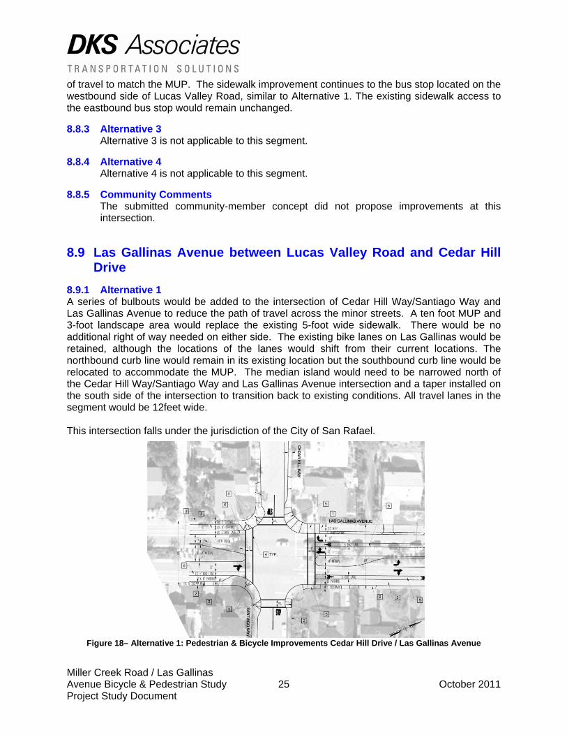
8.9.1 Alternative 1 A series of bulbouts would be added to the intersection of Cedar Hill Way/Santiago Way and Las Gallinas Avenue to reduce the path of travel across the minor streets. A ten foot MUP and 3-foot landscape area would replace the existing 5-foot wide sidewalk. There would be no additional right of way needed on either side. The existing bike lanes on Las Gallinas would be retained, although the locations of the lanes would shift from their current locations. The northbound curb line would remain in its existing location but the southbound curb line would be relocated to accommodate the MUP. The median island would need to be narrowed north of the Cedar Hill Way/Santiago Way and Las Gallinas Avenue intersection and a taper installed on the south side of the intersection to transition back to existing conditions. All travel lanes in the segment would be 12feet wide. This intersection falls under the jurisdiction of the City of San Rafael.
Figure 18– Alternative 1: Pedestrian & Bicycle Improvements Cedar Hill Drive / Las Gallinas Avenue

Miller Creek Road / Las Gallinas Avenue Bicycle & Pedestrian Study 26 October 2011 Project Study Document
8.9.2 Alternative 2 A series of bulbouts would be added to the intersection of Cedar Hill Way/Santiago Way and Las Gallinas Avenue to reduce the path of travel across the minor streets. A twelve foot MUP with no landscape buffer would replace the existing 5-foot wide sidewalk. There would be no additional right of way needed on either side. The existing bike lanes on Las Gallinas would be retained, although the locations of the lanes would shift from their current locations. The northbound curb line would remain in its existing location but the southbound curb line would be relocated to accommodate the MUP. The median island would be narrowed north of the Cedar Hill Way/Santiago Way to 11 feet wide. At the Cedar Hill intersection, a taper would be installed on the south side of the intersection to transition back to existing conditions. A single 12-foot travel lane would be provided southbound between Lucas Valley Road and Cedar Hill Drive. At Cedar Hill the southbound dedicated right turn lane and dedicated left turn lane would be eliminated. The all-way stop condition at this intersection is recommended to be retained. In the northbound direction there are two 11-foot travel lanes approaching the Lucas Valley Road intersection, one a dedicated left turn lane and the other a through/right turn lane. This segment falls under the jurisdiction of the City of San Rafael.
Figure 19 – Alternative 2: Pedestrian & Bicycle Improvements Cedar Hill Drive / Las Gallinas Avenue
8.9.3 Alternative 3 Alternative 3 is not applicable to this segment.
8.9.4 Alternative 4 Alternative 4 is not applicable to this segment.
8.9.5 Community Comments The submitted community-member concepts did not propose specific improvements at this intersection.
Miller Creek Road / Las Gallinas Avenue Bicycle & Pedestrian Study 27 October 2011 Project Study Document
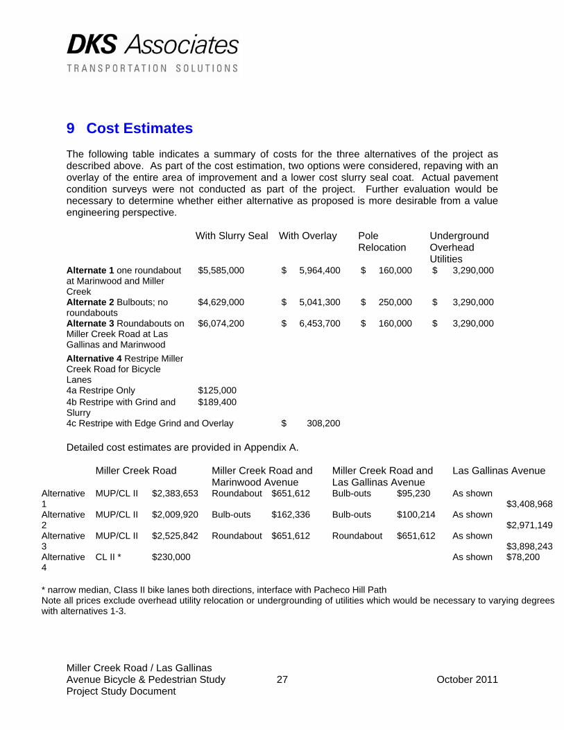
9 Cost Estimates The following table indicates a summary of costs for the three alternatives of the project as described above. As part of the cost estimation, two options were considered, repaving with an overlay of the entire area of improvement and a lower cost slurry seal coat. Actual pavement condition surveys were not conducted as part of the project. Further evaluation would be necessary to determine whether either alternative as proposed is more desirable from a value engineering perspective. With Slurry Seal With Overlay Pole
Relocation Underground Overhead Utilities
Alternate 1 one roundabout at Marinwood and Miller Creek
$5,585,000 $ 5,964,400 $ 160,000 $ 3,290,000
Alternate 2 Bulbouts; no roundabouts
$4,629,000 $ 5,041,300 $ 250,000 $ 3,290,000
Alternate 3 Roundabouts on Miller Creek Road at Las Gallinas and Marinwood
$6,074,200 $ 6,453,700 $ 160,000 $ 3,290,000
Alternative 4 Restripe Miller Creek Road for Bicycle Lanes
4a Restripe Only $125,000 4b Restripe with Grind and Slurry
$189,400
4c Restripe with Edge Grind and Overlay $ 308,200 Detailed cost estimates are provided in Appendix A.
Miller Creek Road Miller Creek Road and Marinwood Avenue
Miller Creek Road and Las Gallinas Avenue
Las Gallinas Avenue
Alternative 1
MUP/CL II $2,383,653 Roundabout $651,612 Bulb-outs $95,230 As shown $3,408,968
Alternative 2
MUP/CL II $2,009,920 Bulb-outs $162,336 Bulb-outs $100,214 As shown $2,971,149
Alternative 3
MUP/CL II $2,525,842 Roundabout $651,612 Roundabout $651,612 As shown $3,898,243
Alternative 4
CL II * $230,000 As shown $78,200
* narrow median, CIass II bike lanes both directions, interface with Pacheco Hill Path Note all prices exclude overhead utility relocation or undergrounding of utilities which would be necessary to varying degrees with alternatives 1-3.
APPENDIX A: Cost Estimate Details
APPENDIX B: Traffic Counts
APPENDIX C: Detailed Plan Alternative 1
APPENDIX D: Detailed Plan Alternative 2
APPENDIX E: Detailed Plan Alternative 3

APPENDIX F: Detailed Plan Alternative 4
APPENDIX G: Community Member Submitted Design Concepts
APPENDIX H: Existing Conditions Memorandum
APPENDIX I: Traffic Analysis
APPENDIX J: Public Input