![[Work-in-Process] + [Work-in-Progress]](https://static.fdocuments.in/doc/165x107/6177daa2b274dc18b82c0ce1/work-in-process-work-in-progress.jpg)
Project objectives Work progress and … objectives Work progress and achievements Project...
87
Project objectives Work progress and achievements Project management Core part of the Mid-term Report Date 31 October 2012 Lead authors: Contributors Periodic Report °1 Final version Tom D’Haeyer, Trui Uyttendaele, Ethel Pirola Sara Namirembe, Robyn Johnston, Fonda Lewis, Masoom Hamdard, Stefan Liersch, Raphaëlle Ducrot, Gregory Giulani
-
Upload
truongthuan -
Category
Documents
-
view
237 -
download
0
Transcript of Project objectives Work progress and … objectives Work progress and achievements Project...

Project objectives
Work progress and achievements
Project management
Core part of the Mid-term Report
Date 31 October 2012 Lead authors: Contributors
Periodic Report °1
Final version
Tom D’Haeyer,
Trui Uyttendaele,
Ethel Pirola
Sara Namirembe, Robyn Johnston, Fonda Lewis, Masoom Hamdard, Stefan Liersch, Raphaëlle Ducrot, Gregory Giulani

AfroMaison Periodic Report N°1 - v2.doc page 2

AfroMaison Periodic Report N°1 - v2.doc page i
COLOPHON Project: AFROMAISON
Africa at a meso-scale: adaptive and integrated tools and strategies for natural resource management
Prepared under contract from the European Commission / FP7 Collaborative project / grant agreement n° 266379.
Title Project objective, Work progress and achievements Project management - Core part of the Mid-term Report Lead Authors Tom D’Haeyer, Trui Uyttendaele, Ethel Pirola Contributors Sara Namirembe (ICRAF), Robyn Johnston (IWMI), Fonda Lewis (INR), Masoom Hamdard (UNESCO-IHE), Stefan Liersch (PIK), Raphaëlle Ducrot (CIRAD), Gregory Giulani (UNIGE/GRID) WP / Deliverable N° / Description WP1 Periodic Report Report number Report 1 Due deliverable date 31 October 2012 Actual deliverable date 31 October 2012 Dissemination level RE Contact Antea Group Tom D’Haeyer Poortakkerstraat 41 B-9051 GENT [email protected] T : +32(0)9 261 63 00 F : +32(0)9 261 63 01 www.anteagroup.be www.afromaison.net

AfroMaison Periodic Report N°1 - v2.doc page ii
CONTENTS
PUBLISHABLE SUMMARY ..................................................................................... 2
CORE OF THE REPORT.......................................................................................... 6
1 PROJECT OBJECTIVES FOR THE PERIOD..................................................................... 7
2 WORK PROGRESS AND ACHIEVEMENTS DURING THE PERIOD........................................... 9
2.1 PROJECT MANAGEMENT (WP1)................................................................................. 9 2.2 MULTI-DISCIPLINARY RAPID ASSESSMENT & BARRIERS FOR EFFECTIVE INRM (WP2) ................... 9 2.3 STRATEGIES FOR RESTORATION &ADAPTATION (WP3) .................................................... 19 2.4 ECONOMIC TOOLS & INCENTIVES (WP4) .................................................................... 24 2.5 TOOLS FOR SPATIAL PLANNING (WP5)....................................................................... 36 2.6 GLOBAL CHANGE, VULNERABILITY & SCENARIO DESIGN (WP6)........................................... 47 2.7 OPERATIONAL FRAMEWORK & TOOLBOX FOR ADAPTIVE INRM (WP7) ................................... 50 2.8 DISSEMINATION, CAPACITY BUILDING & END-USER INVOLVEMENT (WP8)............................... 57
3 PROJECT MANAGEMENT ..................................................................................... 66
3.1 CONSORTIUM MANAGEMENT TASKS ........................................................................... 66 3.2 OVERALL ACHIEVEMENTS....................................................................................... 67 3.3 CHANGES IN THE CONSORTIUM................................................................................ 67 3.4 ADVISORY BOARD............................................................................................... 68 3.5 PROBLEMS WHICH HAVE OCCURRED AND HOW THEY WERE SOLVED OR ENVISAGED SOLUTIONS ........ 69 3.6 IMPACT OF POSSIBLE DEVIATIONS FROM THE PLANNED MILESTONES AND DELIVERABLES, IF ANY; ..... 72 3.7 COMMUNICATION AND IMPACT................................................................................. 72
4 DELIVERABLES AND MILESTONES ............................................................................ 1
4.1 DELIVERABLES .................................................................................................... 1 4.2 MILESTONES ...................................................................................................... 2
5 EXPLANATION ON THE USE OF RESOURCES................................................................. 1
5.1 OVERALL STAFF EFFORTS PER PARTNER;........................................................................ 1 5.2 THE OVERALL EXPENDITURE...................................................................................... 2 5.3 CONCLUSION ...................................................................................................... 3
REFERENCES........................................................................................................ 4
TABLES
Table 1 – Overview of rapid assessment process in case studies................................. 11
Table 2 - Summary of preliminary inventory of economic instruments as incentive for improved integrated natural resource management in developing countries....................................................................................................... 26
Table 3 – Characteristics for spatial planning tools.................................................... 38
Table 4 – List of project meetings........................................................................... 66
FIGURES
Figure 1 - Decision Support Tool for selecting economic instruments (www.afromaison.net)....................................................................... 30
Figure 2 - Mapping regulating services(left) and all ecosystem services (right) for the South African case (Maloti Drakensberg Transfrontier Project, 2007)....... 41

AfroMaison Periodic Report N°1 - v2.doc page iii
Figure 3 - Ecosystem service distribution map (left) and Vulnerability map (right)for the Ethiopian case study (source: Mulugeta, 2012)..................................... 42
Figure 4 - Spatial distribution of selected wetland uses, 1997-2001 for Uganda (source Wetlands and Management department et al., 2009) ............................ 43
Figure 5 - Methodology followed for mapping the ecosystem services in particular to wetlands.......................................................................................... 44
Figure 6 - Flood extend maps for Inner Niger Delta (Zwarts et al., 2005) .................... 45
Figure 7 - Ecosystem Service Maps Oum Zessar (OSS, 2012) .................................... 45
Figure 8 - The AfroMaison broker is available at: http://afromaison.grid.unep.ch/gi-cat/gi-portal .............................................................................................. 61

PROJECT PERIODIC REPORT
Grant Agreement number: 266379
Project acronym: AFROMAISON
Project title: AFRICA AT A MESO-SCALE: ADAPTIVE AND INTEGRATED TOOLS AND STRATEGIES FOR NATURAL RESOURCES MANAGEMENT
Funding Scheme:
Date of latest version of Annex I against which the assessment will be made:
Periodic report: 1st
� 2nd
□ 3rd □ 4
th □
Period covered: from M1 (01/03/2011) to M18 (31/08/2012)
Name, title and organisation of the scientific representative of the project's coordinator:
TOM D’HAEYER – PROJECT MANAGER - ANTEA GROUP
Tel: +32 (0)9 261 63 40
Fax: +32 (0)9 261 63 01
E-mail: [email protected]
Project website address: WWW.AFROMAISON.NET

AfroMaison Periodic Report N°1 - v2.doc page 1
Declaration by the scientific representative of the project coordinator
I, as scientific representative of the coordinator of this project and in line with the obligations as stated in Article II.2.3 of the Grant Agreement declare that: � The attached periodic report represents an accurate description of the work carried out in this project
for this reporting period;
� The project (tick as appropriate) 1:
� has fully achieved its objectives and technical goals for the period;
□ has achieved most of its objectives and technical goals for the period with relatively minor deviations.
□ has failed to achieve critical objectives and/or is not at all on schedule. � The public website, if applicable
� is up to date
□ is not up to date
� To my best knowledge, the financial statements which are being submitted as part of this report are in line with the actual work carried out and are consistent with the report on the resources used for the project (section 3.4) and if applicable with the certificate on financial statement.
� All beneficiaries, in particular non-profit public bodies, secondary and higher education establishments, research organisations and SMEs, have declared to have verified their legal status. Any changes have been reported under section 3.2.3 (Project Management) in accordance with Article II.3.f of the Grant Agreement.
Name of scientific representative of the Coordinator: Tom D’Haeyer
Date: 31/10/2012
For most of the projects, the signature of this declaration could be done directly via the IT reporting tool through an adapted IT mechanism and in that case, no signed paper form needs to be sent
1 If either of these boxes below is ticked, the report should reflect these and any remedial actions taken.

PUBLISHABLE SUMMARY
Project context
Natural resources are essential for maintaining or improving people’s livelihood, especially in Africa. Integrated management of natural resources (INRM) is a way to maintain ecosystems capacity to produce a broad range of goods and services considering African socio-economic conditions and institutional frames. Despite the availability of many tools, expertise, local practices and indigenous knowledge, the concept of INRM has hardly been brought into practice and the building blocks in many cases still need to be integrated.
Effective INRM in many cases is not achieved due to a lack of exchange of information and a lack of coordination between many actors involved at different scales. Furthermore, external pressures are affecting the availability of natural resources. Many of the poorest people in the world typically are highly vulnerable to external shocks (e.g. drought, floods, famine, disease outbreaks).
AfroMaison is making use of what is available to contribute to a better integration of the main components of natural resource management into a coherent integrated and adaptive management process at meso-scale. We define the meso-scale as that level (sub-national) to which power has shifted after decentralization in many countries in Africa. Due to the relative youth of meso-scale authorities and institutions, their capacity for integrated natural resources management (INRM) needs to be strengthened. From a natural resources point of view, the meso-scale corresponds to a landscape, ecosystems or a river (sub)basin.
The challenge of AFROMAISON is to provide a holistic toolbox and operational framework for INRM that can be applied in a variety of environmental and socio-economic conditions in Africa. At the same time, following a participatory analysis of opportunities and challenges, it provides participatory management options for operational INRM, which are both embedded in local traditions and culture, and are scientifically sound.
The objectives
The overall research objective of AFROMAISON is to contribute to bring the concept of Integrated Natural Resources Management (INRM) into practice at the meso-scale. For this purpose, we will develop an integrated toolbox and operational framework for INRM, based on the available tools, data, capacity and requirements for sub-national authorities.
Specific objectives are:
Objective 1: To identify opportunities, challenges and operational requirements for the adoption of tools, strategies and methodologies at the meso-scale
Objective 2: To provide a holistic and multi-disciplinary framework for long-term integrated natural resources management, in line with sustainable development principles.
Objective 3: To improve the capacity of sub-national authorities on INRM to assure economic and social well-being of communities

AfroMaison Periodic Report N°1 - v2.doc page 3
Objective 4: To improve the exchange and transfer of information and procedures for communication on natural resources management
Objective 5: To contribute to bring concepts for INRM into operational practice, including vulnerability, ecosystem goods and services, adaptation to global change (including climate change)
Objective 6: To evaluate and inter-compare promising tools and strategies on applicability, suitability (fit-for-purpose), sustainability for livelihood and ecosystem, cost-effectiveness (incl. impact) and cultural acceptance
AfroMaison is part of the FP7-AFRICA-2010 call jointly implemented by Theme 1: 'Health', Theme 2: 'Food, Agriculture and fisheries, and Biotechnology' and Theme 6: 'Environment (including climate change)'. The aim of this call is to address some of the Science & Technology objectives of the "Africa – EU Strategic Partnership" putting emphasis on "Water and Food Security and "Better Health for Africa".
Summary of the work performed
The AfroMaison project has developed an operational framework to improve adaptive and integrated management of natural resources in Africa, at meso-scale. This framework is being tested in five case study areas in Africa: Tunisia, Mali, Ethiopia, Uganda and South Africa.
The framework is a stepwise approach that assists the natural resource manager to analyse the context, identify issues, develop scenarios, identify options and integrate these into strategies. Subsequently the resulting integrated strategies are tested on acceptance and suitability.
A rapid assessment (Operational Framework Phase 1.1 / WP2) was undertaken in all case studies, using a variety of methods; namely secondary data collection, Participatory Landscape Appraisal (PaLA), Participatory Analysis of Poverty, Livelihoods and Environmental Dynamics (PAPOLD), Rapid Appraisal of Drivers of Land Use Change (DriLUC), and Rapid Agroforestry Practices, Systems and Technologies (RAFT).
Stakeholders have participated in a visioning exercise and the formulation of scenarios (Operational Framework Phase 1.2 /WP6). A focal issue was defined for all case studies and conceptual maps (Cmaps) were developed in order to understand, discuss and structure case study-specific problems.
A comprehensive climate report was delivered for all case studies using the WATCH forcing data. The statistical regional climate model was applied to all cases and the dynamical regional climate models REMO and CCLM were applied for the Rwenzori, Fogera, and Drakensberg case studies.
For the purpose of quantitative assessment of vulnerability, the eco-hydrological model SWIM is being set up in case studies to quantify changes of land use management and climate change on the water balance and crop production.
Option identification (Operational Framework Phase 2 / WP3,4,7) has started in all case studies and is leading to the development of strategies (Operational Framework Phase 3 / WP3,7).
A framework for assessment of options linked to the phases of operational framework has been agreed. The steps includes; (1) Identification of a “long-list” of possible management options, (2) Screening and suitability analysis of
potential options to produce a “short list” of proposed interventions, (3) Comparison and ranking of the effectiveness, (4): Detailed evaluation of the potential impacts and outcomes, and (5) design of monitoring and evaluation plan.
Tools for identifying interventions and assessing suitability as well as tools for strategy formulation have been reviewed. These include (1) Participatory approaches (including WATAGAME, “Happy Strategies” game, “innovation platform”, participatory video, and linking to district government stakeholder processes), (2) system dynamics approaches, and (3) spatial planning approaches.
A Decision Support Tool has been developed – based on a review of economic instruments - to assist the process of context-specific-instrument matching with the aim of highlighting the economic instruments that have the greatest potential to create meaningful incentives to change the behaviour of people to improve the way they use and manage environment in a specific contexts.
Also a review of spatial tools (WP5) has been undertaken based on literature and case studies. Approaches for spatial mapping of landscape functioning using ecosystem services are being tested in all case studies.
A Spatial Data Infrastructure (SDI) has been put in place with as primary objective to provide a basis for geospatial data discovery, evaluation and application. The brokering approach has been adopted to find, access, and integrate various types of data coming from different scientific or non-scientific communities.
The expected final result
The final products that will be delivered at the end of the project are a guideline for natural resource managers and facilitators explaining the stepwise process of context analysis, option assessment, strategy building and testing, as well as how this process can be customized to fit local circumstances, and a toolbox allowing the users to chose between a number of tools that fits his/her needs.
The process needs to be flexible in such a way that it can be applied in a wide range of differing contexts, and that it can be embedded in existing planning and management processes. At each step the natural resource manager or process facilitator is offered a number of tools that may assist him or her in achieving particular goals. Tools are presented with varying degrees of complexity, resource or capacity needs.
The toolbox is meant to be an open ended toolbox. Besides a number of AfroMaison developed and tested tools it will lead users to existing resources available on the web and will encourage a community of practitioners to keep adding resources.
The manual and toolbox will be complemented with case studies, demonstrating how the framework can be customized and how different tools can be applied.
The guideline and toolbox will be supported by examples from the case studies.
AfroMaison Periodic Report N°1 - v2.doc page 5
Expected impact
To create impact, traditional sectoral and scattered management approaches need to move towards more integrative and adaptive approaches. The framework and tools that AfroMaison is developing can support this process.
In order to create impact, two levels need to be addressed. Policy makers need to be convinced and natural resource managers need the right skills. Therefore, AfroMaison during the second project period will focus on two main action areas;
1. To create impact we need to raise awareness and convince influential people at these levels. One or two well targeted policy events will be scheduled for showcasing success stories.
2. To create impact we need to train people in the use of integrated and participatory approaches, this includes training NRM mangers and process facilitators (e.g. NGO-staff, local consultants). For this purpose we are looking into the possibilities for setting up a summer course in English and in French.
More information on www.afromaison.net
CORE OF THE REPORT
Core of the report for the period: Project objectives, work progress and
achievements, project management

AfroMaison Periodic Report N°1 - v2.doc page 7
1 Project objectives for the period
The overall research objective of AFROMAISON is to contribute to bringing
the concept of Integrated Natural Resources Management (INRM) into
practice at the meso-scale. For this purpose an integrated toolbox and operational framework for INRM is being developed, based on the available tools, data, capacity and requirements for sub-national authorities.
Specific objectives are:
• Objective 1: To identify opportunities, challenges and operational requirements for the adoption of tools, strategies and methodologies at the meso-scale
• Objective 2: To provide a holistic and multi-disciplinary framework for long-term integrated natural resources management, in line with sustainable development principles. The framework aims to integrate landscape functioning, livelihood, socio-economic development, indigenous knowledge and local practices and institutional strengthening
• Objective 3: To improve the capacity of sub-national authorities on INRM to assure economic and social well-being of communities
• Objective 4: To improve the exchange and transfer of information and procedures for communication on natural resources management
• Objective 5: To contribute to bring concepts for INRM into operational practice, including vulnerability, ecosystem goods and services, adaptation to global change (including climate change)
• Objective 6: To evaluate and inter-compare promising tools and strategies on applicability, suitability (fit-for-purpose), sustainability for livelihood and ecosystem, cost-effectiveness (incl. impact) and cultural acceptance
Whereas most of these objectives are being achieved in a continuous process, in this period we have concentrated mainly on achieving objectives 1 and 2.
The main objectives for each work package as reported are;
WP1 � To implement the project in an efficient and effective way
� To facilitate the exchange and communication between project partners.
� To monitor and report on progress and use of resources
WP2 � To apply well-developed/tested methodologies and approaches for assessing, understanding multi-functionality across sectors, scales and disciplines at the landscape scale.
WP3 � To identify and adapt promising strategies for restoration of degraded natural resources in the context of current and future

pressures on those resources;
� To apply selected tools at the case study;
� To evaluate the impact of tools and strategies on landscape functioning and livelihoods.
WP4 � To identify and assess a range of tools that are supported by economic incentives to promote improved integrated natural resource management (INRM).
WP5 � To analyse spatial planning processes and tools in relation to INRM, and to give recommendations for tailoring tools / or introducing new tools to better integrate NRM across scales and across sectors.
WP6 � To assess the vulnerability of natural resources and societies in the case study areas in terms of exposure to different pressures, sensitivity to management and climate and resilience to changes under different scenario conditions (climate, population, economy, management, etc.);
� To map vulnerability at the meso-scale;
� To show pathways for reduction of vulnerability.
WP7 � To make sure that tools developed under WP3 to WP5 respond to stakeholders issues and objectives and are adapted to local contexts;
� To organize the analysis of tools tested under WP3 to WP5 in a common way and to integrate the outputs from these WPs to inform adaptive INRM;
� To facilitate the uptake of tools by stakeholders, their capacity building and empowerment and dissemination of tools produced during the project in collaboration with WP8;
� To develop criteria for the evaluation of operational performance of tools and strategies
� To improve the exchange of information, communication and cooperation across sectors and scales
� To develop a set of operational strategies for adaptation and vulnerability reduction to global change
WP8 � to promote policy impact and uptake of research results at the case study and with international institutes and platforms.
AfroMaison Periodic Report N°1 - v2.doc page 9
2 Work progress and achievements during the
period
2.1 Project Management (WP1)
WP1 is reported in the section “project management”.
2.2 Multi-disciplinary rapid assessment & barriers for
effective INRM (WP2)
Lead participant: ICRAF – Type: RTD
2.2.1 Work package objectives for the period
The objective of WP2 is to apply well-developed (including testing) methodologies and approaches in order to assess and understand multi-functionality across sectors, scales and disciplines at the landscape scale. More specifically, WP2 sought to:
� Qualitatively assess landscape multi-functionality by identifying how one aspect of the landscape (drivers of land use change) affects functioning or state of the other land units and its related consequences
� Analyse opportunities and constraints for operational INRM in terms of multi-functional landscapes; livelihood and institutional arrangements;
� Assess the potential of novel concepts such as ‘rewards for ecosystem services (RES)’
2.2.2 Work progress and achievements
Task 2.1 Rapid assessment of multi-functionality across disciplines, sectors and scales
The assessment was undertaken from May to August 2011, using a variety of methods, namely secondary data collection, Participatory Landscape Appraisal (PaLA), Participatory Analysis of Poverty, Livelihoods and Environmental Dynamics (PAPOLD) which included Focus Group Discussions (FGDs) and Key Informant (KI) interviews, Rapid Appraisal of Drivers of Land Use Change (DriLUC), and Rapid Agroforestry Practices, Systems and Technologies (RAFT). The analytical framework used in the assessment was the ‘Drivers-State-Response’, which is currently in use by the CGIAR Consortium Research Programme (CRP) 6 on Forest, Trees and Agroforestry. The framework uses a series of broad research questions in order to determine drivers of land use change; the state and role of biodiversity and environmental services (ES’s) in livelihood strategies; the institutional and governance frameworks in natural resource management (NRM); the consequences of landscape compositions and spatial configuration of stakeholders; and, how external supporters and stakeholders can influence landscape structure in order to improve functionality and reduce conflict.
Tools offered
The assessment used primary and secondary data information. A set of gathering techniques has been proposed at an early stage of the project. A booklet was shared with case study leaders covering the following tools:
� Participatory Landscape Appraisal (PaLA): PaLA was designed through packaging some appropriate Rapid Rural Appraisal/ Participatory Rural Appraisal (RRA/PRA) tools/methods in combination with an approach of agro-ecological analysis in order to capture local knowledge at relevant temporal and spatial scales.
� Participatory Analysis of Poverty, Livelihoods and Environment Dynamics
(PAPOLD): The method is asserted to be participatory, dynamic and comparable. PAPOLD also helps researchers to understand the livelihood strategies that people use to get out of poverty and how much these impact on the environment.
� Rapid Appraisal of Drivers of Land Use Change (DriLUC): The objective of DriLUC is to provide a systems-level understanding of the way local drivers of land use change in a relatively broad landscape relate to external conditions and types of local/regional/national feedback that currently relate impacts on livelihoods and the provision of goods and services.
� Analysis of Land Use and Cover Trajectory (ALUCT): ALUCT requires reconciling the top-down view from satellites with the bottom-up perspective of farmers. Landscape representation, in this case of the format of the land use and cover map, is important base information for sustainable landscape planning.
� Rapid Appraisal of Agroforestry Practices, Systems and Technology (RAFT): Specific terms for specific forms of agroforestry are needed before we can understand the strengths and weaknesses of the use of woody perennials as providers of goods and services, and appreciate the opportunities for and threats to their further enhancement. RAFT requires a botanist. The RAFT framework provides guidelines for the description and analysis of the ways trees are used in rural livelihoods.
� Rapid Hydrological Appraisal (RHA): RHA aims to provide clarity on: o How watershed function is provided; o Who could be responsible for providing watershed service; o How watershed function is being impacted upon at present; and o How rewards can be channelled to effectively enhance or at least maintain
the function.
RHA requires a hydrologist and can help to bridge the gaps of knowledge that may exist between various watershed stakeholders. It is also viewed as an approach that can lead to integration and linkage of all knowledge systems.
� Community-based monitoring of watershed services: Simple and inexpensive tools for community-based monitoring of watershed services blend indigenous knowledge with science (ASB Policy brief No. 2). For example, seasonal stream flow can be measured with ropes, sticks and floats. The population of aquatic invertebrates can be monitored with only hand lens, a pan, a small net and an identification key, which has been published by the

AfroMaison Periodic Report N°1 - v2.doc page 11
Green World Foundation. Tools also exist to enable communities to monitor water quality, rainfall and assess the risk of flooding, landslides, and soil movement (ASB Policy brief No. 7). Community based monitoring can establish the origin of water pollutants within the watershed by measuring contamination using water samples from a series of points along the stream. This helps to reduce tensions.
These gathering techniques were brought to the case studies during different field missions as described in Table 1.
Table 1 – Overview of rapid assessment process in case studies
Country Date of field mission
Method or what happened in the field
Stakeholders met
South Africa
June 2011 Key Informant Interviews; farming systems and stakeholder analysis using PAPOLD
National Department of Agriculture, Thukela WMA; Advisory Services; Farmers Association, University of Kwazulu Natal
SWOT of uThukela District Municipality
Participants of at least 4 past projects
Uganda July 2011 Focus Group Discussion using DriLUC and PAPOLD
Community groups; Farmers Association
Key Informant Interviews; farming systems and stakeholder analysis using PAPOLD
Staff at local agricultural office, district environmental officer and NGOs
Interviews; transect walks; Village sketch maps on patterns of cover; timeline of land use/ cover change using PaLA; RAFT
Farming households
Ethiopia August 2011 KI and interviews; transect walks; Village sketch maps on patterns of cover; timeline of land use/ cover change using PaLA and PAPOLD
Farming households and local development agents
Focus Group Discussion using DriLUC and PAPOLD
Farming households
Mali November 2011
Key Informant Interviews; farming systems and stakeholder analysis using PAPOLD
With local government officials and farming households
Tunisia June 2011 Key Informant Interviews; farming systems and stakeholder analysis using PAPOLD
Local NGOs and farming households
Focus Group Discussion using DriLUC and PAPOLD
Farming households

Information generated
Information generated from primary sources included:
� Ecosystem services provided in the study area
� Major constraints to NRM in upstream/downstream areas
� Threats to farming systems
� Local NRM challenges
� Patterns of land cover/land use change
� Drivers of land cover/use change
� Status of natural resources
� Consequences of Land Use Change (LUC) on livelihoods
� Potential management options and technology selection
� Local institutions
Secondary information was obtained from existing national documentation and desktop research. In the case of Ethiopia, information was also obtained from the IWMI institution. Information from secondary sources also included national level NRM governance, climate, soils, change in land cover over time, topography, elevation, demography, household income, household size, farming systems, and any past or on-going integrated natural resource management (INRM).
Findings were transcribed to analyse drivers of land use change, consequences and status of natural resources and environmental services in order to assess potential for integrated natural resource management in the local and national context of each site. During Month 9-12, draft reports were shared with case study leaders and comments raised were duly addressed. Case Study (CS)leaders then presented draft reports to 30-40 local stakeholders (from national and local government, NGOs and partner universities) in a series of one-week country-level workshops (except in Mali where political conditions did not allow workshops with local stakeholders).
The five individual case studies were combined as chapters into a single report (Deliverable D2.1) with an executive summary and introductory chapter.
Task 2.2 Participatory review of opportunities, constraints and priorities for operational INRM for each case study
Opportunities and constraints for INRM in the sites were identified mainly through focus-group discussions and key Informant interviews for each of the five case studies. Details of the findings can be found in each of the case study chapters (Deliverable D2.1). A summary of the findings is presented below.
Tunisia
A combination of local and modern scientific knowledge has evolved over time to adapt and manage the very limited natural resource base in Oum Zessar. Various research and development interventions have been conducted in the watershed on NRM, agriculture and livelihood improvements. The decentralised governance structure for NRM enables taking key decisions at the governorate
AfroMaison Periodic Report N°1 - v2.doc page 13
and district levels although public participation in decision-making and democratic space is relatively new. This change process has led to strong emergence of NRM-based NGOs, community based-organisations (CBOs) and civil society groups. However, the central government influence and control remains strong which undermines local preferences and decision-making over NRM. Participation of some local actors, especially women, is largely limited
The major constraints or weaknesses for INRM mainly emanate from the very scarce water (quantity and quality) resource. Land and natural ecosystems are very vulnerable to changes in utilisation such as the recent agricultural and pastoral activities including:
� Expansion of tree crops, vegetables and forages;
� Expansion of the irrigated area in light of limited and overexploited groundwater; and
� Natural regeneration of the Dhahar given anthropogenic pressures (land clearing and agricultural development) and drought.
The local economy is small with few options outside the agricultural sector (trade, services, small business, tourism) and low potential for job creation, especially for the youth. Intra- and inter- sectorial integration (agriculture, tourism, services and other sectors) is weak and conflict sometimes exists. Financial resources are not sufficient to achieve INRM. In general, new research tools and methods and capacity are needed to integrate complex social and natural resource problems.
South Africa
South Africa has a very strong national economy with comprehensive and wide-ranging environmental sector policies, programs and institutional infrastructure at central and local government levels for operational INRM. However, local capacities vary between municipalities and provinces. The country is committed to various international conventions for sustainable development and environmental protection. The major constraint is the distrust between authorities and local people originating from the apartheid era resulting in mis-management or mis-appropriation of public resources, inadequate environmental investment and lack of enforcement of well-intended policies.
At the watershed level, poverty is pervasive, land tenure is insecure and basic infrastructure and social capital are inadequate. However, NGOs have managed to build good relations with local groups.
Mali
The Inner Niger Delta (IND) is well placed geographically straddling between the Northern and Southern regions, and borders Burkina Faso to the East and Mauritania to the West. The reciprocity, complementarities and solidarity in all systems of agro-pastoral and fisheries production is a great opportunity for INRM at the local level. The debate offers a variety of livelihood options including tourism, pastoralism, livestock farming and fishing. Many political and legal mechanisms are in place for protection and conservation of natural resources consistent with international conventions, agreements and treaties. Structures (public, parastatal and private) for supporting NRM are also in place. The

decentralized structure increases space for participation of all stakeholders in decision making.
Variability of rainfall conditions and silting of the rivers threaten agricultural, pastoral and fisheries productivity resulting in food and economic insecurity of households in the IND. Poor infrastructure is also a key challenge. The erosion of traditional self-help and solidarity systems means that social cohesion is weakening resulting in confusion and escalating conflict. Official institutions are also poorly coordinated. The population growth rate is high, fuelled by high natural births and immigration.
Approaches to Mitigate Constraints and Challenges:
� Development of an NRM master plan for the IND, which identifies and monitors technical, scientific, social, environmental and climate change indicators.
� The refinement of tools for flood prediction in order to disseminate the information to stakeholders for better planning.
� Development of water control techniques are necessary for development activities.
� Strengthening the capacities of actors, including civil society organisations.
� Promotion of consultation, coordination and synergy among development actors.
Ethiopia
The national government has made NRM a national priority, and a Sustainable Land Management (SLM) Secretariat was instituted under the Ministry of Agriculture. The decentralised form of governance, which enables government and NGO Development Agents to operate at the Woreda level, makes education and information dissemination on INRM easier. A number of NRM institutions operate in the watershed. Farmers seek natural resource management solutions to food scarcity, particularly during the hunger season between June and September. Farmers are also looking for ways to reduce the amount of manual labour required on farms.
However, the fact that land tenure is primarily controlled by the State, local INRM solutions for rural dwellers must obtain prior national approval. Tenure insecurity also means that less value is placed on natural resources. The land-size allocated by the State often does not take into consideration the growing family sizes, limiting opportunities for land use to go beyond food production. With growing population, natural resources are being exploited more for food production and practices with immediate benefits are preferred. Conflicts between upstream and downstream resource users have increased. Traditional agricultural practices persist, because of cultural pride, low levels of education and literacy. High poverty levels also limit adoption of any NRM actions requiring high levels of credit.
Uganda
The soils in the Rwenzori region are fertile and water is abundant. The major challenge is landslides in the steeper areas. Development of locally relevant NRM is possible due to a decentralised governance structure, strong social

AfroMaison Periodic Report N°1 - v2.doc page 15
cohesion among local communities, a high concentration of NRM-based NGOs and CBOs in the area, and supportive NRM policies and laws. Policy implementation is however weak and farming populations distrust government officials. High poverty levels prevent adoption of good, but expensive land management practices (e.g. terracing). Preferred NRM practices are those that increase income and maintain long-term land productivity.
Task 2.3 Potential of novel concepts for operational INRM
The concept of integrated natural resources management (INRM) has been developed over the last decades incorporating aspects from older concepts like adaptive management (AM) and building further on integrated water resources management (IWRM) and Farming system research (FSA) (Douthwaite, Ekboir et al. 2005). Despite the fact INRM is a more recent, broad approach. Almost all scientific research is currently directed to IWRM and integrated catchment management. Hardly any recent peer-review articles are describing and assessing the INRM framework. Concepts like INRM and IWRM have been increasingly criticized for its limited translation into (successful) practice. New concepts should therefore focus on implementation and improve the operational framework of INRM.
On the other hand Cook and Spray (2012) state: If those interested in water research and management are to have a positive impact on the sustainable
utilization of dwindling water resources, they must break the tendency to jump
from concept to concept and confront the challenges that arise with
implementation”. We can wonder whether the integration of more concepts within the framework will improve INRM or whether current existing concepts should first be tested. A constant increase in the complexity of the framework will make it only more difficult to thoroughly test INRM.
To our knowledge few novel concepts have recently been developed that can be incorporated in the INRM framework. Potential concepts should somehow solve present, recognized problems within the INRM and IWRM frameworks. Many authors have addressed and analyzed these problems in the last decade and have identified a broad list of possible constraints for successful implementation (Gottret and White 2002; Merrey 2008; Allen and Gunderson 2011). Although most of the criticism is directed to IWRM, many of these are also relevant to INRM too:
� Unclear definition of the framework.
� Difficulties with assessing scales and complexity
� Inability to explain the dynamic role of social influences on management.
� The failure to incorporate IWRM or INRM into governance.
� The concept cannot be easily transferred to governance.
� ….
The new concept or framework that currently gets the most attention within natural resources management and nature conservation is the ecosystem service approach (Fisher, Turner et al. 2009). The ecosystem service approach can be seen as a promising concept that can improve the link between the socio-economic and ecological system within the INRM framework. But the concept is still in its development phase with many (theoretical) issues unresolved. How the ecosystem service approach will relate to frameworks like INRM is not yet clear.

At the moment it can be used as an independent framework for ecosystem assessment or integrated into existing concepts like INRM and IWRM. Although the concept seems to be promising, several authors are already warning that the concept will run into the same problems as INRM and IWRM. As it does not (yet) address many of the above stated problems. (e.g Norgaard 2010; Cook and Spray 2012)
Assessment of potential of novel concepts in case studies
Given the very different context in each case study, the potential for operational Integrated Natural Resource Management has been assessed for each case individually. These assessments are based primarily on the current framework in each of the participating countries and its application. The main findings are:
Ethiopia
Novel concepts tend to be tied with strong property rights at the local level. The challenge in Ethiopia is that land tenure belongs to the State, and adoption of novel concepts at the local level may need prior state approval. Weak property rights weaken farmers’ willingness to invest in land. Traditional agricultural practices remain strongly entrenched and changes are not quickly embraced. High poverty levels, limited income earning opportunities, exacerbated by population growth, could all hinder INRM. Landholding size is very small in relation to household size and levels of education and literacy rates are very low.
Tunisia
Given the fairly recent political instability, market approaches may also not be feasible; the flow of watershed services (maintenance of deep and surface ground waters and reduced sedimentation) from a provider to a beneficiary is also hard to establish.
South Africa
South Africa has already generated experience in ecosystem oriented natural resource management e.g., the Working for Water, Working for Wetlands and Working for Fire programs. Also the development of taxation instruments to account for transpired water by trees in water limited areas reflects a leaning towards new concepts of NRM. The major hindrance is the distrust between authorities and local people, originating from the apartheid era. Negotiations and manoeuvring will need to be a strong part of the INRM package – NGOs can play a major role.
Uganda
Payment for ecosystem services (PES) is already piloted in the site. However, given the high level of poverty and poor infrastructure in the area, market-based approaches are not likely to be successful as there are few options for ecosystem buyers (some tourism). Land tenure challenges, weak policy implementation and poor governance may also constrain these approaches.
Mali
Novel concepts for INRM in Mali are needed as existing NRM approaches seem to be breaking down. For market-based approaches, however, seller-buyer relations ought to be clearly defined. The flow of ecosystem services (seller/buyer) also need to be established.

AfroMaison Periodic Report N°1 - v2.doc page 17
Potential of Payment for Ecosystem Services (PES)
Potential of PES and alternative economic or policy instruments has been evaluated for each case study. This information will further inform the selection and assessment of tools in the case studies in combination with other measures. A review article on PES by ICRAF is in Press with ARER Review (van Noordwijk M, Leimona B, Jindal R, Villamor GB, Vardhan M, Namirembe S, Catacutan D, Kerr J, Minang PA, Tomich TP, 2012. Payments for Environmental Services: evolution toward efficient and fair incentives for multifunctional landscapes. Annual Review of Environment and Resources 37 (in press). The potential is reported in WP4.
Ecosystem Health
A internal working paper on ecosystem service approaches was prepared, exploring the possibility to integrate the concept of ecosystem health more explicitly. This was done by a taskforce and spans several work packages. The concept is further being integrated in the AfroMaison assessment process.
Task 2.4 Lessons learned and compilation of tools for rapid assessment of the landscape scale
A combination of both, development (inputs/support) and market-oriented approaches to INRM should be integrated in all the watersheds. Although policy and legal provisions are in place in almost all countries, systems for implementation and enforcement are weak due to poor financing. Ecosystem planning and management requires costly structural changes and increased financing; a condition that most governments are not likely to provide. One of the principal problems is the remoteness of the sites in relation to district centres and institutional offices.
The key question in achieving INRM is under what institution meso-scale plans will be administered and financed. Loose voluntary networks tend to dissolve unless clear mutual incentives and motivations exist. NGOs could play a key role in holding various sectors accountable on their commitments to INRM, but would not be the appropriate vehicle for this approach. In Ethiopia, the Woreda Agricultural Office would play a key role in using development approaches in promoting INRM (especially focusing on improved rainwater management and equitable sharing of the resource) as markets are unclear for ES in the Fogera District.
The decentralized government boundaries do not coincide with ecosystems boundaries and may end up as barriers fragmenting integrated management. Local governments which were only created during the last two decades are yet to mature in their roles and are constrained by governance and financial challenges. Superimposing an ecosystem-based approach should therefore be phased and negotiated within the framework of development priorities.
In arid and harsh environments such as Tunisia, Mali and Ethiopia, only a few ecosystem types exist and the key challenge in the integration is in reducing vulnerability by maintaining the narrow and delicate buffer against climate, social and market changes. Approaches focus on sustainable exploitation and equitable distribution of access to resources, thus government institutions and social integration play a major role. In areas of higher diversity of natural

resources such as Uganda, vulnerability to negative changes may be lower, but poverty levels are high and institutional integration becomes more complex.
Community based natural resource management via development of catchment management plans seems to have focused on rallying community participation in government programs for resource management existing in discrete sectors (e.g wildlife, forestry, water etc.), but ignored the development of mechanisms that would enable sector linkages to achieve an integrated approach. Without higher-level institutional and sectoral integration, focusing on just the grassroots level achieves little in addressing natural resource management or reducing poverty and tends to create confusion.
The existing experience in aggregating many smallholder farmers to achieve an integrated approach to NRM tends to be patchy and short-term. Government-championed actions such as in South Africa and Tunisia are better grounded than those led by NGOs. Aggregation of farmers to levels that past cooperatives had in terms of capacity building, economic security and achieving economies of scale should be explored.
No inter-sectoral planning, implementation and monitoring of landscape approaches was evident as sectors had discrete mandates with just a few provisions for interaction in regulatory mechanisms. While reviews of policy provisions may be required to oblige sectors to undertake INRM, an incentives-approach should be identified for voluntarily interaction both amongst public sectors and between public and private or non-governmental entities.
There is, likewise, no experience on integrated natural resource management to which public and private entities commit over a long term. Market-based approaches to rally private sector resources into natural resource management could entail a range of actions such as simply reviewing the levy/tariff systems and channelling the revenue into INRM, increasing incomes flows from agriculture and natural resource based enterprises and payments for ecosystem services. The Mali, South Africa and Uganda case study mention PES is already piloted or at least being considered, and has shown potential for expansion as the threats to ecosystem functioning and the negative externalities of poor land use increase. Given the high poverty levels in all sites, livelihood improvement should be an integral part of INRM.
Tools for rapid assessment were mainly extracted from the TULSEA tool kit previously generated by the ICRAF South East Asia Program. These were shared with case study leaders during the rapid assessment. Some of the tools were presented during the stakeholder session in September 2011 held in Carry le Rouet (France). A brochure containing all the information of the tools was shared with participants.
The following needs were addressed as requested:
� The case study leader in South Africa was assisted by Dr. John Gathenya (a partner of ICRAF) with the GenRiver model.
� The case study leader in Uganda was given advisory support on use of PaPOLD tool.

AfroMaison Periodic Report N°1 - v2.doc page 19
2.2.3 Deliverables
N° Deliverable status
D2.1 Report on context, opportunities and constraints for operational INRM
100%
2.2.4 Person months delivered
Person-Months Delivered Planned Remaining
Antea Group 2,43 2 0
ICRAF 16,5 10 0
INR 5,4 4 0
OSS 3,5 4 0,5
PIK 1,29 2 0,71
WI 2,33 4 1,67
IWMI 2 2 0
2iE 3,4 4 0,6
CIRAD 2,13 0 0
A&W 0,08 0 0
MMU 6 6 0
UA 2,01 2 0
2.3 Strategies for restoration &adaptation (WP3)
Lead participant: IWMI – Type: RTD
2.3.1 Work package objectives for the period
The objectives of WP3 are:
� To identify and adapt promising strategies for restoration of degraded natural resources in the context of current and future pressures on those resources;
� To apply selected tools at the case study;
� To evaluate the impact of tools and strategies on landscape functioning and livelihoods.

2.3.2 Work progress and achievements
Task 3.1 Develop framework to identify tools and strategies, and constraints and opportunities
Framework for assessment of interventions (tools and strategies) has been agreed, with stage approach linked to phases of operational framework - WD3.2 “Afromaison assessment framework”,
A staged approach will be used; the phases of the assessment, within the project phases from WP7, are as follows:
� Phase 1: Identification of a “long-list” of possible management options (tools, approaches and strategies) relevant to the case study, based on opportunities and constraints identified in WP2
� Phase 2: Screening and suitability analysis of potential options to produce a “short list” of proposed interventions to address specific management issues in different parts of the landscape, using structured checklists and PROCA “hurdles”
� Phase 3: Comparison and ranking of the effectiveness of short-listed options in a landscape context, using spatial analysis of ecosystem services and functions (in collaboration with WP5); combination of interventions (including physical, social and economic measures) to produce integrated strategies (WP4,5,7)
� Phase 4: Detailed evaluation of the potential impacts and outcomes of integrated natural resource management strategies for the case study areas, taking account of interactions and synergies at the meso-scale. Evaluation will be tailored to each case study, depending on the strategies adopted.
� Phase 5: design of monitoring and evaluation plan.
Review of the international literature on land and water management has been completed; based on this a typology of interventions and compilation of online databases and other resources relating to NRM in Africa (see WD3.1 “Identifying Interventions”).
Tools for identifying interventions and assessing suitability have been reviewed and evaluated; these cover a range of complexity (see D3.1 “Tools, strategies, processes and good practices on INRM”)
� Simple checklists - PROCA “hurdles”
� Intervention cards – description against locally defined criteria
� Automated and/or guided interrogation of databases / compilations of intervention case studies (WOCAT, AgWater, 3R and others)
� Multi-objective decision support software (MODSS)
� Suitability map

AfroMaison Periodic Report N°1 - v2.doc page 21
Tools for strategy formulation have been reviewed (see D3.1 “Tools, strategies, processes and good practices on INRM”):
� Participatory approaches (role play games, stakeholder platforms) to ensure broad consultation
o WATAGAME (under WP7) as primary tools for strategy formulation in 3 case studies
o “Happy Strategies” game in Fogera, used to help stakeholders formulate strategies at by combining interventions across different landscape zones
o “Innovation platform” for stakeholder consultation in Fogera catchment
o Linking to district government stakeholder processes in Drakensberg and Fogera
o Use of participatory video in Fogera,
� System dynamics approaches to capture feedbacks and interactions (including both qualitative conceptual mapping and quantitative simulation modelling)
� Strategic adaptive management, to encourage flexible and iterative approaches to planning, implementation and evaluation
� Spatial planning approaches to strategy formulation are covered under WP5
Task 3.2 Apply framework to identify best practices and promising tools and strategies for the case studies
Progress within each case study is outlined in D3.1 “Tools, strategies, processes and good practices on INRM”
Fogera, Ethiopia:
� Long list of interventions identified and screened and intervention cards produced for short list of interventions (Catherine Pfeifer)
� Preliminary work on strategy formulation using “Happy Strategies” game, to be followed up by WATAGAME
� Innovation platform (established under NBDC) identified priorities relating to free grazing and water management
� Ecosystem service (ES) in the Fogera district have been assessed at local and regional scales
� Scenario workshop (under WP6) provided insights on community priorities and concerns.
Drakensberg, South Africa
� Review of planned NRM interventions in integrated development plans (IDPs) of local and district municipalities

� Assessments of ecosystem services in the Drakensberg case study area have been made at three levels: identification of major ES types and their importance; mapping of ecosystem services at two scales based on land cover; and economic assessments of ES
� Long list of potential interventions have been identified to address specific NRM issues
� Existing tools for assessment of interventions reviewed
� Approaches to strategy formulation have been agreed, based primarily around the inputs to uThukela District Municipality planning process, to formulate an Environmental Management Plan; and using principles of Strategic Adaptive Management
Oum Zessar, Tunisia
� Key ecosystem services have been assessed using the TEEB methodology and represented spatially by linking to land cover / land use mapping, based on six major land units
� Potential interventions have been identified on the basis of existing techniques, stakeholder consultation and interrogation of the WOCAT database (as part of the DESIRE project).
� Existing approaches have been evaluated on the basis of production, cultural, ecological and off-site impacts and outcomes (under DESIRE project), based on field experiments, on the long term experience of the coordinating team and consultations with farmers
� There is currently a process underway to formulate broadly based local development strategies, including but not limited to, natural resources management. Participatory workshops held on 17 and 30 May 2012 identified management actions for three areas (Beni Khedache, Sidi Makhlouf et Medenine Nord). These were assessed in terms potential availability of funding under the 11th integrated development plan (IDP) for the municipality (2007 – 2011), the proposed budgets for 2012 and 2012; and PDRI, PGRN. Identified actions covered all sectors, including employment, services, education, health and tourism as well as agriculture and NRM. At the workshop in Medenine 5-7September 2012, a process of discussion to prioritise these actions was begun (but not concluded).
Rwenzori, Uganda
� NRM issues and potential responses have been identified on the basis of existing programs, and stakeholders consultations. Local stakeholders have identified potential interventions at five scales (household, village/community, district, region and national). Activities / interventions for different stakeholders (smallholders, commercial famers, pastoralists, fishermen, etc) were identified as part of the Watagame consultations.
� Options integration and strategy formulation is taking place using WATAGAME, reported under WP7

AfroMaison Periodic Report N°1 - v2.doc page 23
Inner Niger Delta, Mali
� Because of the direct relationship between flood level and land use, information on expected annual flooding is critical for local communities to plan seasonal activities. For this reason, Afromaison project in DIN will focus on the contribution that improved information on flooding can make to NRM planning and management, rather than on specific on-ground interventions. The study centres on the use of OPIDIN, a modelling tool developed to predict flooding and flood performance for users groups in the delta.
� OPIDIN will be optimised and tailored to the issues identified for each study area. Stakeholder groups have identified issues of concern and key questions for management
� A survey has been designed to investigate problems related to the management of natural resources, levels of degradation and the effectiveness of response options. The survey will take the form of structured interviews with focus group of fisherman, ranchers and farmers.
Task 3.3 Tools for understanding impact and sustainability of strategies on livelihoods and environment
Progress of work
� A range of GIS based tools for assessing impacts of strategies on land are being evaluated under WP5 (see Section 2) and WP6 (see REPORT).
� Ecosystem services assessment and mapping has been undertaken in all case studies as a framework against which to assess impact and sustainability of interventions.
� ECOSAUT model is being tested in the Ethiopian case study (under NBDC) to assess the consequences of land use types and management practices on farm income, employment opportunities, and environmental indicators such as run off and sediment.
� Hydrological modelling - SWAT / SWIM suite of hydrological (rainfall – runoff) models will be used in some case studies (Ethiopia, Drakensberg) to assess the spatial changes in surface water availability related to changes in land use and land management.
� Water balance / water allocation models is being developed for Oum Zessar to evaluate water development and management options
� OPIDIN or ‘Outil de Prediction des Inondations dans le Delta Intérieur du Niger’. OPIDIN is a predictive model to forecast the flooding of the Inner Niger Delta; a digital flood model is based on satellite imagery of flood extent and 55 years of hydrological data.
Task 3.4 Inter-comparison of high potential strategies between case study sites
Planned in the second period

Task 3.5 Synthesis of results and recommendations for case studies, delivery to other work packages
Planned in the second period
2.3.3 Deliverables
N° Deliverable status
D3.1 Tools, strategies, processes and good practices on INRM: Part A
This deliverable has been merged with D4.1 and D5.1 into
one document to form a coherent report on tools, strategies
and good practices on INRM.
100%
2.3.4 Person months delivered
Person-Months Delivered Planned Remaining
Antea Group 3,13 2 0
INR 2,1 6 3,9
OSS 7,5 10 2,5
UNESCO 1,04 4 2,96
PIK 2 6 4
WI 2,92 7 4,08
IWMI 9,51 8 0
2iE 3,3 4 0,7
CIRAD 0,61 0 0
A&W 0,01 0 0
MMU 4 10 6
2.4 Economic tools & incentives (WP4)
Lead participant: INR – Type: RTD

AfroMaison Periodic Report N°1 - v2.doc page 25
2.4.1 Work package objectives for the period
Work Package 4 (WP4) focuses on identifying and refining of instruments for the implementation of INRM which are supported and driven by economic incentives. WP4 aims to identify and assess a range of economic instruments to incentivise improved integrated natural resource management (INRM). Appropriate responses under different scenario conditions (e.g. land tenure, climate change etc) are considered and tested through a range of case studies to demonstrate the relevance and usefulness of different tools in various contexts in developing countries. This work package involves identifying economic instruments, and designing implementation frameworks for target instruments as incentives for the implementation of INRM. WP4 tasks include:
Task 4.1: Review of a suite of tools currently being applied internationally
Task 4.2: Select potential suitable instruments for individual case studies
Task 4.3: Design implementation of target tools for selected case studies
Task 4.4: Evaluation of impact and sustainability of selected tools
Task 4.5: Inter-comparison and exchange of best practices between case study sites
Task 4.6: Recommendations and guidelines
This report reviews and summarises progress under Activities 4.1 and 4.2 to date, and planning towards Activity 4.3.
It is important to note that at a Case Study level WP4 is closely associated with WP3 and WP5. The aim of WP4 is to support the identification of economic instruments that can create meaningful incentives for target interventions and strategies identified through WP3 (restoration and rehabilitation), and within a given spatial context (WP5). The rollout of WP4 within the case studies is therefore contingent on their having selected their target interventions and understanding of the spatial and planning context within which the restoration and rehabilitation strategy is to be implemented. For this reason Task 4.3 (Design implementation of target tools for selected case studies) can only be initiated once the Case Studies have selected their interventions and strategies (for restoration and rehabilitation) for which they require economic instruments as incentives.
2.4.2 Work progress and achievements
Task 4.1 Review of a suite of tools currently being applied internationally
Task 4.1 involves the review of economic instruments that are or have been applied internationally to offer incentives for improving integrated natural resource management. This review, together with information highlighted during the rapid assessment (WP2), has helped to plan and inform the processes in Task 4.2 and 4.3.
The review of economic instruments was undertaken and concluded with the preparation of an Internal Working Paper, documenting the findings of the review of economic tools and incentives currently applied internationally. This review informed the definition of economic instruments and the categories of instruments adopted in the AfroMaison Project. This review highlighted those

instruments that hold the greatest potential for meeting the desired objectives across the case studies.
The key conclusions drawn from the review are that an economic instrument can be defined as: "Any instrument that aims to induce a change in behaviour of economic agents by internalizing environmental or depletion cost through a change in the incentive structure that these agents face (rather than mandating a standard or a technology) qualifies as an economic instrument" (Panayotou, 1998). Anderson et.al. (2001) suggest an additional definition: “An economic instrument for managing the environment is a policy or combination of policies that provide financial and other inducements so that users of natural resources pay for the social costs of that use”.
Table 2 (below) introduces economic instruments clustered into three groups:
� Price based instruments
� Rights based instruments
� Legal, voluntary and information based instruments
Each group is disaggregated into multiple categories, with each category comprising multiple Instruments. The Table is not a complete inventory of economic instruments, but rather focusses on those that are likely to have the greatest relevance as incentives for integrated natural resource management in the context of the objectives of Afromaison.
Table 2 - Summary of preliminary inventory of economic instruments as incentive for improved integrated natural resource management in developing countries.
GROUP CATEGORY INSTRUMENT
Strengthening ownership rights PROPERTY-RIGHTS
BASED
INSTRUMENTS
Property rights
Securing use rights
Market creation Tradable permits, quotas and shares
Tax differentiation
Input and output taxes
Fiscal instruments
Pollution taxes
User charges / fees
Pollution charges
Product charges or levies
Betterment charges
Impact fees
Access fees
Charge systems
Administrative systems
PRICE-BASED
INSTRUMENTS
Financial Financial subsidies

AfroMaison Periodic Report N°1 - v2.doc page 27
GROUP CATEGORY INSTRUMENT
instruments Payment for Ecosystem Services
Environmental performance
Land reclamation bonds
Environmental
bonds and deposit
refund systems
Environmental accident bonds
Legal liability
Non-compliance charges
Liability
instruments
Natural resource damage liability
Voluntary environmental agreements Voluntary
Instruments
Environmental certification
Labelling
LEGAL, VOLUNTARY
AND INFORMATION
BASED
INSTRUMENTS
Information-based
Public disclosure
Task 4.2 Select potential suitable instruments for individual case studies
Activity 4.2 focuses on building a support process that can assist the Case Studies to select from the shortlisted tool groups and strategies, depending on the local availability of tools, existing landscape interventions, cultural acceptance and meso-scale priorities (as presented in the outcomes of the Rapid Assessment conducted though WP2). The characteristics of each case study will differ and a different instrument or combinations of instruments can be applied as incentives in each. The selection of the appropriate tools is based on the outcomes of the selection of interventions and strategies for restoration and rehabilitation identified through WP3, and relevant within the spatial context (WP5).
Activity 4.2 was therefore concluded with the development of a Decision Support Tool that can be applied to support the Case Studies to assess the instruments that will likely deliver the most effective incentives for the target environmental interventions that they prioritise as a result of the work undertaken with WP3, WP5 and WP6, and in respect of the developed case study work plan.
The aim of WP4 is to support the identification of economic instruments that can create meaningful incentives for target interventions and strategies identified through WP3 (restoration and rehabilitation), and within a given spatial context (WP5). The rollout of WP4 within the case studies is therefore contingent on their having selected their target interventions and understanding of the spatial and planning context within which the restoration and rehabilitation strategy is to be implemented. For this reason Task 4.3 (Design implementation of target tools for selected case studies) can only be initiated once the Case Studies have selected their interventions and strategies (for restoration and rehabilitation) for which they require economic instruments as incentives.

Factors affecting the suitability of economic instruments
The effectiveness of an economic instrument in acting as an incentive for improved environmental management is not only determined by the value/extent of the benefit (incentive). There are a range of factors that will influence the effectiveness of an instrument in a specific context, and key examples of these include:
� Extent to which the instrument matches or aligns with the social, political and economic contexts
� Extent to which the incentive relates to the nature of the environmental challenge and its causes
� Extent to which instrument is perceived as an incentive by the target agents or institutions whose behaviour or management approach is being changed
In developing countries where, typically, financial resources are scarce and there is limited institutional capacity, important criteria for selecting the best economic instruments include (in addition to those listed above):
� cost-effectiveness
� administrative feasibility
� equity
� consistency with other development objectives
� flexibility and transparency
Implementation of a single economic instrument in isolation may not be sufficient for bringing about a desired change in environmental management. A combination of economic instruments may be required, for example instruments that encourage limiting resource use to sustainable levels may also require instruments that strengthen to establish secure use rights for a target user group.
It is therefore important that a conscious process is undertaken to ensure that a selected economic instrument is a good fit with the aimed objective. Inappropriate context-instrument matching could result in no change in use behaviour / environmental management by the target agents or institutions, or may even act as a perverse incentive and result in a change contrary to the desired response.
In selecting economic instruments, implementers or policy makers need to take into account a range of driving forces and contextual characteristics to ensure site-instrument matching and to increase the likelihood that the economic instrument creates meaningful incentives to induce the desired changes in natural resource management by resource users and managers. The following are some of the key considerations in this regard:
a) Identifying and understanding the environmental problem or issue that needs to be addressed, as well as the root cause or driver of the problem. In addition, the context in which the instrument will be implemented also needs to be considered, for example, the social, political and economic realities.
b) Economic instruments rely on market forces, and resultant changes in relative prices (including costs and benefits), to induce a modification in the behaviour of people in managing their impacts to the environment.

AfroMaison Periodic Report N°1 - v2.doc page 29
For this reason it is important to understand the economy / market within which an economic instrument is to be applied to ensure it matches market conditions.
c) Effectiveness of governance systems and administrative capacities are determinants for successful implementation of economic instruments. The pre-existence of effective administration, monitoring and enforcement capacity is a prerequisite for some economic instruments.
d) Local conditions such as development needs and priorities, poverty levels, capacities, tenure types, socio-political stability are factors that will all affect the suitability of economic instruments in terms of improving the willingness of stakeholders to perceive the instrument as an incentive for improved environmental management.
e) The environmental target of the instrument is an important consideration in selecting and matching an instrument with a particular environmental management need.
Developing a Decision Support Tool for selecting economic instruments
A Decision Support Tool (Figure 1) has been developed by WP4, with support from WP8, to assist resource managers or implementing agents to ‘walk’ through the set of selection criteria (economic, social, governance and environment) that will help to evaluate alignment of economic instruments with a the target context. The Decision Support Tool assists the process of context-instrument matching with the aim of highlighting the economic instruments that have the greatest potential to create meaningful incentives to change the behaviour of people to improve the way they use and manage environment in a specific contexts.
The Decision Support Tool is currently loaded on the Afromaison website: http://www.afromaison.net/eco_dss/ and can be either run online or downloaded onto a computer and run offline. A suite of supporting documents is also provided on the website.

Figure 1 - Decision Support Tool for selecting economic instruments (www.afromaison.net)
Fourteen economic instruments are included in this Decision Support Tool. While there are many other types of economic instruments, the 14 included in this Decision Support Tool were selected on the basis of their relevance to the integrated natural resource management objectives of the Afromaison Project.
This Decision Support Tool uses four categories to analyse the potential for applying economic instruments in a particular context: Environmental, Social, Market, Governance. Each of these categories is in turn broken down into multiple criteria.
This Decision Support Tool applies a scoring and ranking process for assessing the suitability of economic instruments against these criteria.
The summary of the average (overall) score per instrument is also graphed for a snap shot comparison of the outcome of the scoring for all instruments in a given context. A link to an information sheet (in PDF format) for each instrument is also provided in the last column.
Preliminary assessment of economic tools and instruments applied in
the Case Studies
Ethiopia � The Rapid Assessment (conducted through WP2) suggested that, at present, a Payment for Ecosystem Services (PES) scheme is not a viable resource management tool in the Ethiopian Case Study, as potential

AfroMaison Periodic Report N°1 - v2.doc page 31
buyer-to-seller relations are not clear and Fogera is missing the required markets of ecosystem services and other ‘open access’ public goods.
� Once the interventions and strategies for environmental management and restoration the Case Study have been selected (with support through WP3), WP4 can provide the necessary support for the Decision Support Matrix to be run to identify incentives for the implementation of these Interventions and Strategies. This process will be designed in consultation with the Case Study leader, who will decide whether the process is incorporated into a stakeholder process or conducted independently by the Case Study Team. The outcomes of this selection process will then be taken into a design phase (Activity 4.3).
Mali The Rapid Assessment (WP2) also reports that at the national level there is no clear evidence of awareness of the opportunities for the application of economic instruments as incentives for improved management and combating environmental challenges. However, there are some initiatives at a local level being promoted by local NGOs that have introduced the use of economic incentive instruments to contribute to effective environment management. Among these is the Bio-right approach, which aims at ensuring that environmental stewardship becomes a condition for access to microfinance institutions, Cereal Bank, rice huskers for women association.
A number conditions highlighted in the Rapid Assessment Report provide examples of opportunities that lend themselves to the introduction of economic instruments as incentives for change:
� Tenure insecurity: opportunity for introducing instruments that look to strengthen ownership or use rights for these natural resources as an incentive for improved responsible.
� Great agricultural potential: opportunities for the introduction of certification schemes to promote responsible (and conservation) agriculture.
� Tourist attractions: Voluntary and information based instruments, such as labelling as certification of tourism operations could be explored.
� Introduction of tradable permits and quotas associated with the use of the rich pastoral and livestock resources, as well as the fishery resources, could be explored as opportunities to regulate the use of these important resources in the Delta.
The Mali case study team has reviewed the Decision Support Tool and indicated an interest in applying the Tool to assist in the selection of potential economic instruments that could be tested in the Case Study.

South Africa Stakeholder interest in the potential use of economic instruments to create incentives for improved environmental management in the case study area has largely focussed on piloting Payment for Ecosystem Services (PES) as a market-based approach to watershed management.
Recently, the South African National Biodiversity Institute (SANBI) commissioned a 4-year business plan for rolling out a PES scheme focussing on water services, with the emphasis being on securing private sector buyers of ecosystem services in order to establish the first true market based scheme. However the initiative recently (July 2012) announced that it is unable to secure a willing private sector buyer for these water services, and has therefore concluded that a true market based PES system is not currently feasible in the area.
This has created a real need to explore alternative opportunities for economic instruments that could create incentives for improved community based environmental management in the case study area.
As a result, the Synergies Forum (a Forum of stakeholders, NGOs, management and research institutions operating in the South African Case Study area) has therefore welcomed the opportunity to run the Economic Instruments Decision Support Tool to try to identify alternatives to PES.
The South African Case Study leader will determine the extent to which the Decision Support Tool is run with a wider stakeholder forum and to what extent stakeholders (as opposed to the steering committee / stakeholder forum) will be involved in Activity 4.3.
Tunisia The Rapid Assessment Report (WP2) highlighted that in the Oum Zessar Case Study area located in southern Tunisia (Medenine Region), economic incentives associated with improved security of land tenure, credits and subsidies have enabled farmers to maintain agricultural activities even in low-potential areas, and this in turn has led to improved productivity and agricultural employment.
Land ownership through privatization has directly influenced land use change, land use practices and exploitation of land resources, as well as employment.
A study was conducted within in the Case Study to analyse the environmental services watershed of Oum Zessar (applying the Economics of Ecosystems and Biodiversity (TEEB) approach to ecosystem services). It was concluded that there is opportunity to use a market-based approach to enhance watershed services, but more time is required before a market-based mechanism can be structured.
AfroMaison Periodic Report N°1 - v2.doc page 33
The Case Study workshop (on 17 July 2012) focused on specific activities related to the classification of Ecosystem Services approach by IWMI (WP3), the evaluation of economic instruments and incentives depending on the Decision Support Tool (WP4). The decision was taken by the Case Study Team to run the Decision Support Tool with the Team and selected local Stakeholders. The outcomes of this exercise are currently being written up in a report by the Case Study, and will be made available as soon as it is complete. In addition, constructive feedback was provided by the Case Study Team to WP4 Team, upon which revisions to the Tool were based.
The Case Study leader has suggested that Phase 2 of the Case
Study (Options assessment) will include the identification of
actions that will include options for economic instruments
(WP4). This will be taken forward into the Design Phase
(Activity 4.3) of WP4.
Uganda The Rapid Assessment (conducted through WP2) highlighted potential opportunities for the establishment of PES systems around the following ecosystem services in the Rwenzori Region: Carbon Sequestration and Climate Regulation, Ecotourism and Cultural Services Biodiversity Conservation through organic agricultural production, Watershed conservation
The WP2 Rapid Assessment report highlights that PES has been piloted in the Albertine Rift region, mainly focusing on carbon sequestration, while an initiative by PRESA focused on water degradation issues.
The main problem which may be encountered when developing PES type schemes in the area is reported to be the difficulty in finding an independent NRM institution which is fully trusted by the community members and who can bring them all together.
Security of tenure throughout rural Uganda has also been highlighted as an issue that needs to be correctly addressed. There are two economic instruments that focus on tenure, namely (i) strengthening of ownership rights, and (ii) strengthening of use rights.
The WP4 Team was invited by the Ugandan Case Study to participate in a stakeholder workshop from 23-27 April 2012. The concept of economic instruments and incentives was presented to the stakeholder and the Decision Support Tool was introduced. Stakeholders, working in three groups, were then given the opportunity to test the Decision Support Tool using interventions for environmental management / rehabilitation that they had selected in the previous workshop session.
The exercise helped the stakeholders to familiarise themselves with the types and range of economic instruments, and role that economic instruments could play in incentivising the

uptake and implementation of environmental rehabilitation or management interventions.
This engagement also helped the WP4 Team to test the Decision Support Tool, and a number of revisions and improvements were implemented as a result of the feedback from this exercise.
The Case Study Team has suggested that they may run the
revised version of the Decision Support Tool at a future follow
up stakeholder workshop to build on the platform laid at the
first workshop.
Task 4.3 Design implementation of target tools for selected case studies
Task 4.3 involves designing the implementation of the selected instruments in each case study and testing their suitability, impact and effectiveness in the context within which they would be applied.
The case study leaders determine the scope and extent of the design phase at case study level, with processes and support provided by WP4 as required. For this reason Task 4.3 (Design implementation of target tools for selected case studies) can only be initiated once the Case Studies have selected their interventions and strategies (for restoration and rehabilitation from WP3) for which they require economic instruments as incentives. WP4 Team is currently engaging with the Case Studies to provide support for the selection of target economic instruments at the case study level.
As the Case Studies select their target interventions through the WP3 assessment framework, so WP4 then supports them to run the Decision Support Tool and identify economic instruments that could create incentives for the implementation of these. This informs the design phase of WP4, during which the strengths and weaknesses of the target economic instruments are analysed and an implementation strategy for the target instrument is reviewed.
Task 4.4 Evaluation of impact and sustainability of selected tools
The following tasks have not yet started, and will be initiated once progress has been made on Activity 4.3:
� Evaluation of impact and sustainability of selected tools: an evaluation framework will be developed and applied to the selected tools at the case studies.
� Inter-comparison and exchange of best practices between case study sites: As a step towards improving the effectiveness of instruments for improved INRM and based on the results of tasks 4.3 and 4.4, lessons learned from the selected and tested tools will be assessed to explore their applicability in varying contexts.
� Recommendations and guidelines: Recommendations and guidelines on modifications or revisions required for improved implementation and effectiveness of the instruments will be developed at two levels:
o Modification of the instruments themselves for improved relevance to particular case studies and contexts

AfroMaison Periodic Report N°1 - v2.doc page 35
o Interventions to the receiving environment, i.e. social, economic or policy interventions required to facilitate the effective implementation of the instruments.
Task 4.5 Inter-comparison and exchange of best practices between case study sites
Planned in the second period
Task 4.6 Recommendations and guidelines
Planned in the second period
2.4.3 Deliverables
N° Deliverable status
D4.1 Tools, strategies, processes and good practices on INRM: Part A
This deliverable has been merged with D3.1 and D5.1 into
one document to form a coherent report on tools, strategies
and good practices on INRM.
100%
2.4.4 Person months delivered
Person-Months Delivered Planned Remaining
Antea Group 2,8 2 0
ICRAF 0 8 8
INR 7,1 14 6,9
OSS 3,5 4 0,5
PIK 0 4 4
WI 0,03 2 1,97
IWMI 0,25 2 1,75
2iE 2 8 6
CIRAD 2,23 6 3,77
UKZN 0,07 8 7,93
MMU 3 8 5
2.5 Tools for spatial planning (WP5)
Lead participant: UNESCO-IHE – Type: RTD
2.5.1 Work package objectives for the period
The overall objective of work package 5 is to analyse spatial planning processes and tools in relation to INRM, and to give recommendations for tailoring tools / or introducing new tools to better integrate NRM across scales and across sectors.
Work Package 5 has progress in Task 5.1 (Review of internationally available spatial planning tools), Task 5.2 (Analysing the spatial planning process at case study level in relation to INRM) and Task 5.3 (Spatial mapping of landscape functioning).
Review of international literature on spatial planning tools and process in natural resources management (T 5.1) is 100% completed and documented in Deliverable 5.1. A conceptual framework is also developed which explains WP5 integration into overall operational framework WP7.
A questionnaire to find out more on spatial planning tools and processes in the case studies is developed and shared with the case study partners. For the case of South Africa and Mali the questionnaire are filled and the review is completed and documented for both case studies while for other case studies the questionnaire are not yet completed. D 5.1 contains for all case studies the review of spatial planning tools and processes based on Rapid Assessment Report. Additional information is obtained during the stakeholders meetings in the case studies.
In task 5.3, ecosystem services mapping is preliminarily explored and discussed with other partners. An inventory was made on ecosystem services mapping in the case studies.
2.5.2 Work progress and achievements
Task 5.1 Review of internationally available spatial planning tools
A compressive literature review on spatial planning tools, process and its
relevance to natural resources management has been conducted and reported in
D5.1.
Within the context of AfroMaison, spatial planning tools are defined as
instruments which can be used;
� In a comprehensive planning process to analyse and/or evaluate data to
support decision-making
� Assist in decisions for the use of natural resources in prudent manner and
in way more transparent for the stakeholders and the public
� Facilitate in communication, negotiation and integration between different
actors

AfroMaison Periodic Report N°1 - v2.doc page 37
Spatial planning tools are for instance maps, models, indicators, geographic
information system (GIS), decision support system (DSS), monitoring concept,
models, multi-criteria analysis (MCA), trade-off analysis or strengths-
weaknesses-opportunities-threats (SWOT) analysis. These type of tools can help
increase understanding of multi-sector and multi-level processes and trade-offs
between policy objectives of different sectors and between different planning
scales. They thus contribute to transparency in decision making. D5.1 gives an
overview of a number of spatial planning tools ranging from very simple mapping
to very complex modeling and a brief overview of the case studies from WP5
perspective.
Categorization and characteristics of spatial planning tools:
Tools are categorized according to their function in the spatial planning process
� Analytical/diagnostic tools
� Problem-solving / decision-aiding tools
� Negotiation support tools
Analytical and diagnostic tools are particularly useful in the first steps of the
planning process, to diagnose and analyze the main issues at stake. These tools
usually aim at identifying management objectives, criteria and requirements,
and developing the analytical framework. In subsequent steps in the planning
progress, problem-solving and decision-aiding tools, such as conflict maps,
multi-criteria analysis and analytical hierarchy processes, are used for priority
setting and optimisation, particularly in case of competing management
objectives or criteria. In addition, negotiation support tools are aimed to
facilitate and support stakeholder participation in the decision-making and
planning process.
Based on the distinctive features mentioned, five categories of planning tools for INRM could be distinguished.
1. Modelling & mapping
2. Software programs
3. Multi-criteria decision analysis (MCDA)
4. Participatory land use planning (PLUP)
5. Community-based management (CBM) & traditional planning
Different characteristics can be distinguished for the spatial planning tool itself,
and the outcome/product of the tool, although some features maybe relevant to
both.

Table 3 – Characteristics for spatial planning tools
Feature Modelling & mapping
Software programs
MCDA PLUP CBM &Traditional Planning
Spatial scale national, regional
national, regional
regional, local local local
Temporal scale long, mid long, mid mid short short
Policy scale macro, meso
macro, meso
meso, local meso, local local
Interdisciplinary + + + + +
Multi-objective + + + + +
GIS-based + + +/- +/- -
Tenure scale state state state communal/private communal/private
Adjustability static static static dynamic dynamic
Variability + - - + +
Zonation system
boundaries
boundaries
boundaries
transitional/boundaries
transitional/boundaries
Stakeholder participation - - +/- + +
Criteria used for selecting spatial planning tools:
Although for few case studies a thorough review of existing spatial planning still
needs to be completed, a general criteria for selecting spatial planning based on
initial review of the case studies and internationally available literature is
developed. The process of selecting appropriate tools will be finalized together
with the case study team and other stakeholders. The criteria set are as follow.
� Availability of tool
� Level of detail/accuracy needed
� Long/short term predictions
� Local, regional, international scale
� Expected range of error
� Time available
� Budget available
� Availability of data
� Availability of expertise and facilities
� Acceptability of tool (and its outputs) by decision-makers and the
scientific community
AfroMaison Periodic Report N°1 - v2.doc page 39
Task 5.2 Analysing the spatial planning process at case study level in relation to INRM
The analysis of spatial planning tools and processes is completed for two case studies based on the questionnaires provided to the case study leaders; this includes South Africa, Mali. Other case studies still need to complete the questionnaire, which will help to get better insights on the existing spatial planning tools and processes. South Africa case study: At uThukela District Municipality, which is a meso-level from south African jurisdictional point of view, about 19 spatial planning tools is identified. The existing tools in the case study are categorized as i) Analytical diagnostic tools
1. NFEPA- National Freshwater Ecosystem Priority Areas
2. Conservation Plan
3. Ecological Reserve Model
4. RWQOs- Resource Water Quality Objectives Model
5. Land Potential
6. ACRU, Pitman etc – hydrological models
7. AGIS -Agricultural Geographical Information System
ii) Problem solving and decision aiding tools
8. Strategic Environmental Assessment
9. BRU – Bio Resource programme
10. LUDS - Land Use Decision System/Tool
iii) Negotiation support tools
11. RQO tool – Resource Quality Objectives
12. Water Resource Classification System
iv) Other spatial planning tools – end results, strategies etc
13. SDF- Spatial Development Framework as part of the Integrated
Development Plan
14. LUMS – Land Use Management System
15. Biodiversity Sector Plans
16. Catchment Management Strategy
17. EMF- Environmental Management Framework (in progress)
18. IDP- Integrated Development Plan
19. Protected Areas Expansion Strategy
Guidelines are available for each tool which clarifies the procedure it should be following and its purpose e.g Integrated Environmental Management Guideline Series 6.
Mali case study (Inner Niger Delta): The spatial planning process in the Inner Niger Delta runs through the administrative levels, in which the regional and sub-regional levels are important (decentralization). Although a spatial planning system and process is existent, the actual exploitation of natural resources in the floodplain for a large part is regulated by traditional systems. Despite the existent planning processes and traditional regulation system, there

are serious concerns about overexploitation of natural resources in the delta. In short this is related to population growth and recurrent low floods, directly impacting on the production of natural resources. Concern is that the situation may even be worsened by the recent rebellion in the northern part of Mali.
Existing planning processes and institutions
In short existing spatial planning tools relevant to the Inner Niger Delta in general are derived from instruments of national and regional planning. In short can be mentioned;
National level
� National plan of town and country planning
� Sectorial and spatial masterplan
� Sectorial national plan
Regional Level
� Regional plan of town and country planning
� Sectioral and spatial masterplan
� Quarterly Investment Programme
� Socio economic and cultural development programme PDSEC
� Strategic Development Plan for the Inner Niger Delta (PDD DIN)
Municipality or communal level
� Municipality plan of town and country planning
� Sectioral and spatial masterplan
� Quarterly Investment Programme
� Socio economic and cultural development programme PDSEC
� Conservation Management plans Akkagoun, Dentaka
� OPIDIN
For other case studies review is still underway.
Task 5.3 Spatial mapping of landscape functioning
Spatial mapping of landscape functioning has focused on mapping of ecosystem services in the case studies. A conceptual approach has been identified for mapping the ecosystem services (TEEB, 2009). Focusing on:
� The core ecosystem processes: these describe the basic ecosystem
processes supporting ecosystem functions
� Beneficial ecosystem processes: these are the specific ecosystem
processes that directly underpin benefits of people
� Beneficial ecosystem services: these are the products of ecosystem
processes that directly impact human wellbeing. Methodologies for mapping these ecosystem services range from very simple approaches using basic information which can be obtained from satellite images (linking the ecosystem services to the different land use type) to very complex

AfroMaison Periodic Report N°1 - v2.doc page 41
approaches requiring a substantial amount of field data (including detailed surveys on the ecosystem services generation and economic valuation methods). For each of the case studies the simple mapping approach will be implemented. More detailed ecosystem mapping has already been carried out in some of the case studies, for example: SOUTH AFRICA CASE STUDY: For the South African case study a mapping exercise was conducted on ecosystem services in the Mnweni/Cathedral Peak and Eastern Cape Drakensberg Areas as part of an assessment for payment for ecosystem services (Maloti Drakensberg Transfrontier Project, 2007; Figure 2).
Figure 2 - Mapping regulating services(left) and all ecosystem services (right) for the South African case (Maloti Drakensberg Transfrontier Project, 2007)

ETHIOPIA CASE STUDY: For the Ethiopia case study a mapping exercise was conducted on mapping rainwater management strategies in the Jeldu, Diga and Fogera areas, through suitability maps for a selection of promising practices (Mulugeta, 2012; Figure 3).
Figure 3 - Ecosystem service distribution map (left) and Vulnerability map (right)for the Ethiopian case study (source: Mulugeta, 2012)

AfroMaison Periodic Report N°1 - v2.doc page 43
UGANDA CASE STUDY: For the Ugandan case study a mapping exercise was done for Uganda on mapping the ecosystem services in particular to wetlands (Wetlands and Management department et al., 2009; Figure 4).
Figure 4 - Spatial distribution of selected wetland uses, 1997-2001 for Uganda (source Wetlands and Management department et al., 2009)
The methodology is based on physically based land-use planning and made up out of several steps (Figure 5). For each land-use type we can draw up suitability maps by a top-down gradual aggregation and valuation of the available maps into the perspectives of respectively the stakeholder, the ecosystem and the policy maker

Figure 5 - Methodology followed for mapping the ecosystem services in particular to wetlands.
Within the AfroMaison project the following maps are or were created for the Rwenzori Region:
� An erosion map for the region was created using the RUSLE equation. The
formula was applied on a soil map of the Rwenzori region in combination
with required elevation and climate data. Based on these data a more
reliable and more detailed erosion map was created.
� Land use maps for the region are created based on the Landsat 5 and 7
images. These data were obtained from NASA and cover a 15 year period.
Combining different methodologies and allow
� The same Landsat images and procedures are also used to create a
deforestation map of the last 15 years.
Based on these map increases of erosion risk, areas for possible soil depletion or zones for potential landslides can be mapped.
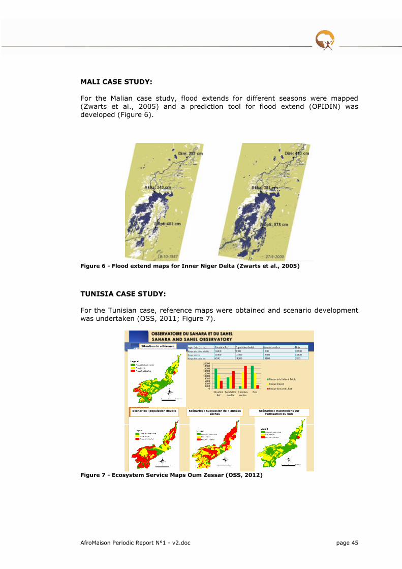
AfroMaison Periodic Report N°1 - v2.doc page 45
MALI CASE STUDY: For the Malian case study, flood extends for different seasons were mapped (Zwarts et al., 2005) and a prediction tool for flood extend (OPIDIN) was developed (Figure 6).
Figure 6 - Flood extend maps for Inner Niger Delta (Zwarts et al., 2005)
TUNISIA CASE STUDY: For the Tunisian case, reference maps were obtained and scenario development was undertaken (OSS, 2011; Figure 7).
AFROMAISON
Kick Off
Didima
23/03/2010
Scénarios : population double
Situation de référence
Scénarios : Succession de 4 années sèches
Scénarios : Restrictions sur l’utilisation du bois
superficie (en ha) Situation Ref Population double 4 années seches Bois
Risque très faible à faible 16000 9000 1900 18200
Risque moyen 11000 10100 13300 12300
Risque fort à très fort 6300 14200 18100 2800
02000400060008000
100001200014000160001800020000
Situation
Ref
Population
double
4 années
seches
Bois
Risque très faible à faible
Risque moyen
Risque fort à très fort
Figure 7 - Ecosystem Service Maps Oum Zessar (OSS, 2012)

Initial work has been carried out in developing suitability maps of different land uses in the Ethiopian case study for the use in SITE application to dynamically model land use change (Yalew et al., 2012).
Preliminary discussion with AfroMaison partners are done on the methodology for Ecosystem services mapping. This is an ongoing activity which will be documented in D 5.2.
Task 5.4 Adaptation and application of selected tools
Planned in the second period
Task 5.5 Inter-comparison of tools for spatial planning and best practices across case studies
Planned in the second period
Task 5.6 Recommendations and guidance for the implementation and operational use planning tools in INRM
Planned in the second period
2.5.3 Deliverables
N° Deliverable status
D5.1 Tools, strategies, processes and good practices on INRM: Part A
This deliverable has been merged with D3.1 and D4.1 into
one document to form a coherent report on tools, strategies
and good practices on INRM.
100%
2.5.4 Person months delivered
Person-Months Delivered Planned Remaining
Antea Group 2,32 10 7,68
INR 3 6 3
OSS 3 4 1
UNESCO 6,14 10 3,86
PIK 1,79 4 2,21
WI 3,08 7 3,92
IWMI 3,9 4 0,1

AfroMaison Periodic Report N°1 - v2.doc page 47
2iE 2,13 6 3,87
CIRAD 2,38 2 0
A&W 3,3 6 2,7
MMU 3 6 3
UA 3,08 6 2,92
2.6 Global change, vulnerability & scenario design
(WP6)
Lead participant: PIK – Type: RTD
2.6.1 Work package objectives for the period
The objectives of WP6 to be achieved were to conduct an initial vulnerability assessment for all case studies. This assessment has a strong qualitative nature and is based on the identification of current drivers and pressures and their trends and the development of a set of scenarios for the case studies.
In order to understand, discuss and compare the problems and vulnerabilities related to natural resources management across the case studies, concept maps (Cmaps) were created and structured according to the DPSIR framework. Recent and future trends of driving forces were identified using this approach.
Scenarios have not yet been built for all case studies but the progress is good. A sound basis for the scenario building was developed by WP6 (Scenario building guideline) and used to facilitate the scenario building process.
A statistical regional climate model was set up for all case studies in order to assess possible impacts of climate change by 2050. Moreover, data from two dynamical regional climate models were analysed for three out of five case studies. Additionally, state-of-the-art Earth-System-Model data, used for the coming IPCC AR5 report, are currently analysed. Results will be included in the climate part of the initial vulnerability assessment report.
Work related to the quantitative assessment of vulnerability has been started by setting up an eco-hydrological model for two case studies, the collection of regional datasets for this purpose, and the development of GIS-based frameworks. The latter serves the purpose of an integrated assessment of future impacts and management strategies. The work was performed across the work packages 3-6 and case study teams.
The Milestone MS3 on “initial vulnerability assessment” is a little bit delayed. This delay is not considered to be critical for other work packages or the progress in the case studies. Reason for the delay is mainly due the scenario building process which was much more complicated and time-consuming than planned during the project setup.
In all other tasks, WP6 is on track.

2.6.2 Work progress and achievements
Task 6.1 Initial vulnerability assessment for each case study
A comprehensive scenario building guideline has been developed with the aim to facilitate the scenario building in the case studies. In the course of the scenario building, a focal issue was defined for all case studies. This was important not only with regard to scenario building but also for a targeted continuation and harmonization of the work across work packages.
Moreover, in order to understand, discuss and structure case study-specific problems, concept maps (Cmaps) were developed for most case studies. They were so far an extremely helpful tool with regard to scenario building, particularly for the identification of driving forces and pressures, but they also serve the purpose of common understanding of the problems. The basis to flesh out future scenarios has been worked out for all case studies. These Cmaps are currently structured according to the DPSIR framework in a second step. This work is mainly related to Task6.4 and serves the purpose of case study inter-comparison.
A comprehensive climate report (past & recent) was delivered for all case studies using the WATCH forcing data. Annual and monthly temperature and precipitation trends over the period 1901-2001 and in more details for the period 1960-2001 were analysed in order to identify and compare climate-related trends of the past.
The statistical regional climate model was applied to all case studies to project future climate in a consistent way. Moreover, the dynamical regional climate models REMO and CCLM were applied for the following case studies: Rwenzori, Fogera, and Drakensberg Grasslands. These findings were added to the climate report.
A chapter on how to proceed with the quantitative assessment has been added to some case studies in the initial vulnerability report so far. This includes data, tools, and indicators to be used and a concept map that helps to identify the different tasks necessary to accomplish the research related to case study-specific questions. This work was jointly conducted with WP3-6 and the respective case study.
Milestone MS3
The milestone MS3 on initial vulnerability assessment has been finished to 85% and will be finalized soon. This delay is not considered to be critical for other work packages or the progress in the case studies. Reason for the delay is mainly due the scenario building process which was much more complicated and time-consuming than planned during the project setup.
Apart from the delay of the Milestone, Task 6.1 is on a good way to be finalized soon.
Task 6.2 Quantitative assessment of vulnerability of the case studies
The eco-hydrological model SWIM (Soil and Water Integrated Model) has been set up for the Fogera case study in Ethiopia. The purpose is to use the model

AfroMaison Periodic Report N°1 - v2.doc page 49
to quantify changes of land use management and climate change on the water balance and crop production.
The SWIM model is also used in the Inner Niger Delta case study. An existing model setup from the EU project WETwin is currently re-calibrated in order to quantify impacts of climate change and upstream land and water management on the inflow patterns into the Inner Niger Delta and to simulate flooding processes. The existing model setup is currently improved by including all existing and planned upstream reservoirs and planned extension of irrigated land.
Regional datasets of the Drakensberg case study were collected in order to set up the SWIM model for this case study. The development of a GIS-based framework for the quantification of vulnerability of ecosystem services and livelihoods has been initiated.
It is planned to set up the SWIM model for the Rwenzori case study in Uganda.
A framework of models and tools to be applied to the Oum Zessar case study in Tunisia has been drafted.
In order to quantify the vulnerability related to future climate change, climate projections of several IPCC AR5 global Earth-System-Models have been pre-processed. This analysis will be included into the climate projection report.
Task 6.3 Vulnerability mapping at the meso-scale
WP6 attended a meeting in Antwerp to discuss issues related to ecosystem service and vulnerability mapping.
A literature review on vulnerability mapping has been started.
Task 6.4 Inter-comparison of vulnerability assessment between case study sites and upscaling to African scale
A structuring of case study-specific drivers and pressures according to the DPSIR framework has been started in order to facilitate the case study inter-comparison.
Task 6.5 Operational strategies for adaptation and reduction of vulnerability to global change
Planned in the second period
2.6.3 Deliverables
N° Deliverable status
- No deliverables planned in this period -

2.6.4 Person months delivered
Person-Months Delivered Planned Remaining
Antea Group 1,44 2 0,66
INR 0,3 2 1,7
OSS 3,5 4 0,5
PIK 9,28 18 8,72
WI 0 4 4
IWMI 0,6 2 1,4
2iE 0 4 4
CIRAD 0,35 0 0
MMU 3 4 1
2.7 Operational framework & toolbox for adaptive
INRM (WP7)
Lead participant: CIRAD – Type: RTD
2.7.1 Work package objectives for the period
As stated in the annex 1 description of the work, WP7 objectives is (i) to make sure that tools developed under WP3 to WP6 respond to stakeholders issues and objectives and are adapted to local context (ii) to organize the analysis of the tools tested under WP3 to WP5 in a common way and to integrate the outputs from the WPs to inform adaptive INRM (iii) to facilitate the uptake of the tools by stakeholders, their capacity building and empowerment and dissemination of the tools produced during the project in collaboration with WP8 (iv) to develop criteria for the evaluation of operational performance of tools and strategies (v)
AfroMaison WP7 supports the integration, coherence checking and implementation design for the INRM strategies in the different CS.
The ultimate aim of AfroMaison can be recognized multiple, as from the various partners’ perspectives, but WP7 role is to ensure that results are actually reaching the aim of improving NRM in Africa. Two main risks exist: 1. Providing actions (tools, instruments) which although scientifically validated are never adopted 2. Providing actions whose scope is too limited or contradict others which are in place. Coherence and implementation are the real challenge. It doesn't mean additional expertise and research is not urgently required for the CS, but that it has to be included and considered and processed inside the largest scope of NRM.

AfroMaison Periodic Report N°1 - v2.doc page 51
At this stage of the development of the project, the work developed in WP7 has focused
� On the elaboration of the Operational Framework and support to its implementation in CS to facilitate integration of tools, strategies, and WP.
� Design and test of a multi-level participatory process and use for the assessment of strategies in CS.
2.7.2 Work progress and achievements
Task 7.1 Operational framework for INRM
The objective of this task is to propose a common framework to analyse and assess the performance of tools for INRM in a context of multi-level, decentralisation and global changes. It includes; a literature review, the identification of criteria for the evaluation of tools performances, and the development of a framework to identify and articulate tools and strategies.
Literature review on INRM related approaches
The vast amount of literature available on integrated approaches and related concepts such as landscape approaches, or ecosystem approaches makes a literature review a very extensive assignment. Terms of references have been elaborated to set more specific goals for this planned review. A student of the University of Antwerp has conducted some aspects of this a master thesis. This thesis however has not been completed.
A short review on theoretical aspects concerning scale and environmental governance – and its consequences for WP7 operational framework has been elaborated; the draft is currently being circulated.
Ducrot, 2012, Scale and Governance in Integrated Natural Resources
Management: challenges for the Afromaison project. Contribution to D7.2. Draft
version. 16p.
Identification of criteria for evaluation of tools performance
The evaluation framework of (individual) tool performance has been reallocated to WP3. WP7 focuses on the evaluation of “integrated plan” that is a set of tools packaged into a plan or strategy (geographically and timely defined).
WP7 then focuses on the assessment of the coherence, feasibility, appropriation and implementation of the plan in the long term, based on the expertise provided by other WPs as well as stakeholders inputs. The assessment methodology is integrated in the operational framework. The criteria of assessment of the plans have not been formalized yet. The specificity of WP7 will be to consider the social and institutional transformations as well as the technical changes necessary for INRM.
Development of a framework to identify and articulate tools and strategies

A workshop on participatory research (Carry-le-Rouet, 19-23 Sept. 2011), led to a first definition by each CS (except Mali –who was not represented because of visa difficulties) of their participatory pathways and the role of the different workpackages, in relation with stakeholders and communities.
The workshop also led to the structuring of the Operational Framework, which included a detail of 6 phases as presented in Box 1. The Operational Framework was presented in a central document issued in Dec 2012. The strategy design process of the Operational Framework aims at real inclusion of the target groups in making and engaging into change pathways. Target groups includes meso-scale as well as local scale stakeholders
N. Ferrand, R. Ducrot, S. Morardet. 2011 Guidelines for the implementation of
the operational framework for INRM. AFROMAISON working document.
Box 1 - The 6 phases of the Operational Framework
Phase 0: Procedural design and agreement: design of the contextualized Operational Framework at case study level with the champions.
Phase 1.1: Situation Assessment checking: building of a shared representation of the situation
Phase 1.2: Visioning exercise with all actors
Phase 2: Options identification, assessment and design – selection of possible tools for the situation. Options potential for NRM is supposed to be available1.
Phase 3: Options integration and integrated plan for natural resources management design – selections of sets of options to be tested and locally assessed
Phase 4: Testing the strategy for INRM – with all actors using assessment tools (models, social models, discussion platforms, role playing games etc.).
Phase 5: Designing the implementation procedure of the selected strategy
Subsequently a workshop on participatory planning was organised in Addis- (27 Feb.-3 March 2012), co-hosted with IWMI. During the workshop a full course on participatory integrated planning has been proposed, with a first approach of the use of game for exploring and assessing strategies. This was followed by the Bahar-Dar plenary meeting during which all CS organized their process in relation with the different workpackages.
These activities were complemented by training on the multilevel participatory platform for supporting change (Task 7.4 presented further down)
The setting and definition of the common evaluation process required for producing sound and transferable results was also elaborated and disseminated to case studies. A test of the protocol was undertaken in the Drakensberg case study through an MSc internship.
� R Ducrot, Ferrand N. 2012. What approach and protocol for monitoring and assessment of participatory processes in the AfroMaison project? Concept Note, 11 p.
� R Ducrot, 2012. Protocol for monitoring and evaluation AfroMaison case studie. 25p.
AfroMaison Periodic Report N°1 - v2.doc page 53
State of advancement of the implementation and development of the Operational Framework in Case Study.
The Uganda CS has taken a pilot and demonstration role by acting very quickly to implement the Operational Framework, with a strong engagement of stakeholders and an intensive schedule. Two stakeholder workshops were organized (phases 0-2: 24-27 April 2012 in Kasunga ; phases 3-4: 31 July – 1st August 2012 in Fort Portal). As of august 1, 2012, phases 0 to 4 are very advanced, although downscaling to local communities has not yet taken place. Evaluation has been established.
Uganda CS is considered from WP7 perspectives as a pilot case. Many reasons make it a good demonstration site, although the pace chosen can by itself be a drawback: such processes normally require a slower “social time” for dissemination to take place. It means that all CS should seriously consider it and exchange with MMU about this experience. The last operational session with a group of 25 stakeholders (July 31 – august 1st) has clearly shown that the game is not a gadget of AfroMaison WP7 but a key tool to engage stakeholders in a multi-scale multi-issues discussion about NRM. The Ugandan team and stakeholders have required and organized themselves to expand the use of the game much further in their society.
The Tunisian and Ethiopian CSs are in a similar situation: they have already had several stakeholders workshops with intermediary stakeholders, addressing actions and plans, in coordination with other supporting projects. However the process has not implemented strictly the phases 2 and 3 of the operational framework. And they already reflect stakeholder “fatigue” at this stage, whereas some central actions have not yet started. Some results are available with a framework different from WP7 OF. Inclusion of local communities is not yet taking place. Evaluation has been considered to be too demanding.
The South-African CS is at a very early stage of stakeholders’ participation. Only one meeting has taken place with a representative open group, but without some parts of the local society (“tribes”). Difficulties have been repeatedly expressed by the CS leader about possibility to include these groups with the others (Authorities and Commercial Farmers), and also about means for participation and evaluation. External evaluation has taken place through direct intervention of WP7 (MSc internship of Melanie Pommerieux under the supervision of M. Bourblanc and R. Ducrot).
The Mali CS has suffered from the local political situation with the ongoing civil conflicts. The local CS manager has been embedded for long into local participatory processes and can build on a long term knowledge and practice of NRM in the Inner Niger Delta. However the participatory process has actually been started only recently, but with a significant inclusion and dynamic, at intermediary level. This CS presents the difficult feature of being almost non accessible to any European white person, for security reasons.
Conclusion on the development of the framework
A large investment has been made by WP7 in addressing and transferring practices for participatory research, integrated planning and participatory simulation (almost 300 Men-days now). But the absence or point-wised participation of some CS in these actions may have led to loosing capacity and understanding of the process.
Task 7.2 Impact pathway for the uptake of tools by natural resources managers
Impact pathways are identified to increase the likeliness for the project to achieve the desired impacts. Or briefly summarised it is a process that assists the project team to think through and refine their activities to improve the likelihood of achieving qualitative project outcomes and contribute to impact beyond the project.
The project is following multiple impact pathways; for each case study (aiming at the uptake of results in the case study), and an overall project impact pathways to work towards up scaling and further application of the project results.
Case study level
A first impact pathway has been elaborated by CS team members during the inception workshop. Twelve months afterward, each CS team has been asked to provide an updating of the objectives of their intervention. This impact pathway and objectives have been gathered in a document circulated in WPs and CSs. Two CS (Tunisia/Uganda) has not yet provided the updated impact pathways: in the Tunisia case there was confusion between the approach to be developed and the objectives of the intervention. In the others cases this exercise helped to clarify objectives and specify steps to be undertaken to facilitate dissemination and impact. It clarified the central issue that is being addressed in the INRM.
Through WP6 a vision for development was also elaborated. It remains unclear however to what extent the impact pathway developed has been discussed, shared and validated with all team members and local champions as initially expected The articulation between WP6 vision for development also need to be clarified in some case studies.
Project level (coordination Antea Group)
A task force has been put in place to develop the project impact pathway and to work towards its implementation. Whereas the majority of the tasks undertaking in the project is focussing on conceptual developments, tailoring these to match the specific case study context and test the applicability in case studies, the impact pathway taskforce needs to see to it that this work is leading to operational outputs. This means taking the results out of the scientific domain and making it accessible to practitioners. To achieve this, the following key outputs have been identified;
� The AfroMaison guide to implement INRM planning at meso-scale
� The AfroMaison toolbox to support the implementation of INRM at meso-scale
� The AfroMaison training modules on the use of INRM guide and toolbox
� A Spatial Data Infrastructure
To achieve these outputs partnerships are being sought with development agencies and international organisations for co-development, joint training initiatives and dissemination.
AfroMaison Periodic Report N°1 - v2.doc page 55
Task 7.3 Approaches for integrating local practices and knowledge on NRM with expert knowledge
The Operational framework and participatory platform promoted by WP7 use a Companion Modelling approach which has proved to be efficient in promoting the confrontation, sharing and integration of different perspectives and knowledge (Etienne, 2012).
The Operational Framework is following in strong participatory approach, the methodologies followed at each of the phases allows the inclusion of stakeholders opinions and knowledge. Stakeholders formulate actions resulting in a set of actions being merged together to form a coherent strategy. Where appropriate experts in the project team offer additional or alternative solutions.
Monitoring and evaluation of should help to understand to what extent local practices and knowledge are being taken into account.
Task 7.4 Design, test and assessment of a multi-level participatory platform for supporting changes in NRM
The objective of this task is to support changes in individual and collective practices regarding natural resource management across scales. This will be achieved through the development of a participatory and generic platform for supporting multiple levels stakeholder arena to consider new options for natural resources management, integrate them into their current system (biophysical, social, economic and institutional), and develop the relevant coordination mechanisms to better adapt to global changes.
Design and test of a multilevel participatory process
This joint process on participatory simulation for INRM represents the phase 4 of the Operational framework, where the multi-scale participatory process allows for a more comprehensive integration of scales and issues, before the game acts as a strategy testing process.
Five representatives of the CS were taught, accompanied, supported in designing, testing and using for participatory strategy assessment, games they have designed with experts and some key stakeholders. (3 months continuous, June-August 2012). Three weeks of course are included (Tunisia & Uganda). Financial support was provided by WP7 for this specific action to case studies (all costs of the session held in Tunisia ; outside travel costs of interns to Uganda for the second session).
Although this process was targeted initially at academic interns available during the summer (northern hemisphere), 3 CS (Uganda, Ethiopia, Mali) have chosen to engage into this game design process very qualified staff experts (Clovis Kabaseke, Mulugeta Lemenih, Mori Diallo). This led to a very rich and sustainable process. But it also leads to their concentration into the game process, whereas for Ethiopia and Mali the priority is still in the participatory planning (phases 2 & 3). After discussion we are proposing an alternative approach hybridizing the initial process (in which the game follows the strategy design and serves as tester). The essence of this approach is to start the interactions with stakeholders (especially community levels) with an introductory game session, aiming at setting a new dialogue mood, opening the transversal
issues and reducing the “fatigue syndrome”. Next step would retrieve the “normal” pathway of the Operational Framework, including phase 2 (actions modelling) and phase 3 (strategy building), but with the capacity to refer to and use the game on the way. A normal phase 4 could be done, with the previous experience of the game speeding it.
In some case studies (Ethiopia, Mali, RSA) complementary approach will be used to assess options or set of options.
Monitoring and evaluation of implementation in study sites
The monitoring and assessment protocol elaborated in 7.1 is to be used to monitor the use of the participatory platform in each case study. The protocol aims to distinguish the impact of the approach on the following dimensions: External (improvement of the Natural Resources of the system studied), Normative (values and preferences of the participants), Cognitive (representations and beliefs of the participants), Operational (practices and actions of the participants), Relational (social relationships between participants), and Equity (social justice regime and distribution of resources between participants). However the process evaluation is disregarded by many CS teams because of its supposed cost and probably because it is not clearly acknowledged as a requirement for the validity of results of the operational framework and of the project as a whole. If AfroMaison wants to argue and expand its results, it has to specify what has actually been changed - this is a complex and multi-layered issue- and try as much as possible to disentangle the causes. Validity of results and transferability of approaches are at this cost.
The monitoring has been initiated under CIRAD resources in 2 CSs (Drakenseberg, MSc student and Uganda, PhD of Emeline Hassenforder). Emeline HASSENFORDER’s PhD, initiated in July 2012 (IRSTEA/ University of Canberra) aims to assess how multilevel participatory planning can contribute to the development of meso-scale institutions for natural resources management.
Task 7.5 Development of geo-web services and tools and procedures to communicate scientific and/or expert information on natural resources to local end-users
The work developed in this task is presented in WP8.
Task 7.6 Compilation of toolbox and recommendations
This task is planned for the second period.
The Impact Pathway Task Force has initiated a concept note on the development
of the toolbox. The preliminary setup is leaning towards a kind of meta-data-
catalogue for INRM tools (mostly decision/process tools). Meta-data to include
needs to facilitate the selection of the tools, the catalogue can be browsed,
queried, or entries can be defined in the AfroMaison guide to INRM.

AfroMaison Periodic Report N°1 - v2.doc page 57
2.7.3 Deliverables
N° Deliverable status
- No deliverables planned in this period -
2.7.4 Person months delivered
Person-Months Delivered Planned Remaining
Antea Group 4,43 6 1,67
ICRAF 0 2 2
INR 0,5 4 3,5
OSS 2,5 4 1,5
UNESCO 2,36 6 3,74
PIK 0,73 4 3,27
WI 4,2 6 1,8
IWMI 2,61 3 0,39
UNIGE/GRID 1,5 7 5,5
2iE 0 4 4
CIRAD 8,13 10 1,87
A&W 0 4 4
MMU 3 4 1
2.8 Dissemination, capacity building & end-user
involvement (WP8)
Lead participant: UNIGE/GRID – Type: OTH
2.8.1 Work package objectives for the period
The objective of WP8 is to create as much as possible synergies with other projects in Africa, raising awareness about AfroMaison and bringing some concrete tools for users.
As agreed with Case Study leaders, we are aiming in disseminating the successful progress, findings, methodology, tools, and actions. In our vision, it is important to communicate once we have something concrete to show/share. Do not create expectations but instead show the good results.
Therefore, in this first part of the project, we advertised for the existence and general objectives of the project among different stakeholders (during meetings,

workshops, conferences, etc...).Now in the second phase of the project we will disseminate/inform about the tools, findings, methodology developed in the frame of the project, bringing something concrete to users & stakeholders.
Capacities building workshops and stakeholders meetings at case study levels have permitted to involve the various targeted stakeholders. This has already created some dynamic and fruitful relationships between the project and case studies. We need to continue in this direction in the next phase of the project.
AfroMaison website (http://www.afromaison.net) is (and will be) the entry point for accessing the various tools, reports, documents of the project. This will facilitate access and dissemination of project outputs.
Currently, there are not a lot of scientific publications and consequently we need to be more active on this point. Obviously, in the second half of the project it is expected to have the main outputs and therefore also have more scientific papers presenting projects findings/results.
In the second half of the project, it will be also extremely important to come up with guidelines for the tools/methodologies used/developed in the framework of the project. This will support an effective and efficient implementation at the case study level.
Even if this is not the major objective of the project, currently, AfroMaison has gained some visibility thanks to the development of the Spatial Data Infrastructure and Discovery Broker, as well as participation to the Global Earth Observation System of Systems. We will continue our effort in this sense in order to support discovery and access to environmental data in Africa. Some contacts have been taken with the United Nations Economic Commission for Africa (UNECA), the key player about GIS and SDI in Africa. Joint events/workshops will be certainly developed in the next phase of the project.
Finally the Stakeholder conference that will take place in 2013 will be the major event for the project in term of dissemination of project results.
2.8.2 Work progress and achievements
Task 8.1 End-user communication
Early in the project the case study leaders have been consulted on expectations and communication needs within the case study countries. Case study leaders in this phase of the project have chosen to communicate with care, avoiding so to create unrealistic expectations. Therefore we concentrate in disseminating the successful progress, findings, methodology, tools, and actions as they are being implemented.
In a first stage, we also need at least to advertise for the existence and general objectives of the project among different stakeholders (during meetings, workshops, conferences, etc...).
AfroMaison Partners have participated to various conferences inside and outside Africa, presenting preliminary results and raising awareness about the project.
A lot of information is available on the project website that is acting as the central placeholder to find relevant information/documentation on the project: conferences summaries, flyers, posters, tools documentation, publications, etc...
Currently following materials are available:
AfroMaison Periodic Report N°1 - v2.doc page 59
� website (www.afromaison.net)
� General project flyer in English and French is ready and available on the AfroMaison website.
� Twitter account (@afromaison)
� YouTube channel http://www.youtube.com/afromaison
� Pictures galleries available on the website instead of Flickr
� Linkedin group http://www.linkedin.com/groups/AfroMaison-3865389
� International Innovation paper soon ready
� AfroMaison RSS feed available on the website
The communication strategy will be updated in the second half of the project to prepare dissemination of final outputs of the project, both with the case study countries and a larger international community. We are embedding this strategy in the project impact pathway and we are building synergies with other AFRICA-Call projects and international partners to create a common platform.
Task 8.2 Implementation of geo-webservices and Spatial Data Infrastructure for the dissemination of spatial data and services
As a key aspect to enhance the management capacity of sub-national authorities and communities, the AfroMaison project aims to improve the exchange of information, contribute to filling the gaps and provide a platform for the sharing and geographical expansion of tools for Integrated Natural Resource Management.
Spatial Data Infrastructure
A Spatial Data Infrastructure (SDI) has been put in place with as primary objective to provide a basis for geospatial data discovery, evaluation, and application for users and providers within all levels of government, commercial and the non-profit sectors, academia and citizens (GSDI, 2004).
The AfroMaison SDI is built around Free and Open Source Software to make all data and metadata interoperable, discoverable, accessible and integrable using web services. The metadata catalogue is based on GeoNetwork (http://geonetwork-opensource.org/), and all data services and webGIS applications are developed around the OpenGeo Community Edition software stack (http://opengeo.org/technology/suite/).
The AfroMaison Spatial Data Infrastructure is now fully operational giving access to more than 500 data sets.
The metadata catalogue is available at:
http://afromaison.grid.unep.ch:8080/geonetwork/
The Spatial Data Infrastructure included a number of web services which are being made available to the users. These service are offer the user possibilities to interact with the system over the network.
The following services are available:

� Catalogue Service for the Web (CSW): The OGC Catalogue Service defines common interfaces to discover, browse, and query metadata about data, services, and other potential resources. Web Catalogue Service includes several profiles including Catalogue Service - Web.
http://afromaison.grid.unep.ch:8080/geonetwork/srv/csw?service=CSW&ver
sion=2.0.2&request=GetCapabilities
� Web Map Service (WMS): A Web Map Service (WMS) is a standard protocol for serving georeferenced map images over the Internet that are generated by a map server using data from a GIS database.
http://afromaison.grid.unep.ch:8080/geoserver/ows?service=wms&version=
1.3.0&request=GetCapabilities
� Web Feature Service (WFS): The Open Geospatial Consortium Web Feature Service Interface Standard (WFS) provides an interface allowing requests for geographical features (vector) across the web using platform-independent calls. One can think of geographical features as the “source code” behind a map, whereas the WMS interface or online mapping portals like Google Maps return only an image, which end-users cannot edit or spatially analyze.
http://afromaison.grid.unep.ch:8080/geoserver/ows?service=wfs&version=1
.0.0&request=GetCapabilities
� Web Coverage Service (WCS): The Open Geospatial Consortium Web Coverage Service Interface Standard (WCS) provides an interface allowing requests for geographical coverages (raster) across the web using platform-independent calls. The coverages are objects (or images) in a geographical area, whereas the WMS interface or online mapping portals like Google Maps return only an image, which end-users cannot edit or spatially analyze.
http://afromaison.grid.unep.ch:8080/geoserver/ows?service=wcs&version=1
.0.0&request=GetCapabilities
AfroMaison broker
In such an INRM framework that AfroMaison is developing, it is a necessity to find, access, and integrate various types of data coming from different scientific or non-scientific communities. In other words, a multi-disciplinary framework must support INRM. However currently two common obstacles, among others, are preventing the implementation of such framework: difficulties to find data, and difficulties to integrate data.
One of the major reasons for these problems is that different disciplines involved use different technology, arrangements, protocols, formats, etc... to publish their resources. Therefore, to make various resources interoperable it is required not to change or impose interoperability arrangements within community but instead to try lowering entry barriers for both users and providers.
Consequently, AfroMaison has adopted the brokering approach using the caching and mediation capabilities proposed by GI-cat (http://essi-lab.eu/cgi-bin/ twiki/view/GIcat/) to federate heterogeneous resources (data catalogue and access services). The AfroMaison broker can therefore transform query results to a uniform and consistent interface implementing metadata harmonization and protocol adaptation Figure 8.

AfroMaison Periodic Report N°1 - v2.doc page 61
Figure 8 - The AfroMaison broker is available at: http://afromaison.grid.unep.ch/gi-cat/gi-portal
Task 8.3 Capacity building and strengthening of ownership
Capacity building events have been organised back to back with project meetings when possible and a few special training events have been organised in addition to these (particularly on participatory planning and WP7 related activities).
Case study leaders have received additional support from work package leaders or other partners on thematic issues. Furthermore of trainees, master students and PhD students have benefitted been taking part in project activities.
Training sessions
� AfroMaison training course on participatory approaches to develop integrated
strategies: Carry-le-Rouet (France) for the September 19-23, 2011 session on stakeholder engagement in research and governance was attended by representatives out of 4 of the 5 case studies and representatives from several other partners. During this session the outline of the operational framework has been designed and an introduction was given on participatory planning and the use of WAT-A-Game in the context of INRM strategy building and testing.
Integration is a key work for WP7: this work package aims to integrate the activities developed in other work packages and to develop an operational framework that can help decision makers at meso-scale to select a set of spatially coherent options for natural resources management, or strategies.

The challenge is also to take into account both perspectives and knowledge of local stakeholders and national management objectives: It thus requires the mobilization of stakeholders from different levels in the development of the integrated planning process.
To initiate the development of this operational framework, UMR G-Eau which coordinates WP7, organized a first “training session” in Carry-Le-Rouet near Marseilles (France) between the 19th and 23rd of September. The session facilitated by Nils Ferrand gathered 15 participants who represented cases studies and work packages. Different participatory tools, approaches and postures that can be used to improve knowledge and data collection, to contribute to decision and governance or for evaluation purposes were shared and discussed.
They are organized in order to allow for a multi-level diagnosis of the situation at stake, the participatory selection of different types of options, drafting the foundation of the operational framework for natural resources management. Drawing on case study specificities as well as on WP objectives and tasks, a first plan of activities was elaborated for each case study to be further discussed, developed and validated with research teams and key actors at study sites.
� AfroMaison meeting on Ecosystem Service Mapping: A meeting in mapping of ecosystem services has been organised buy Antea Group in Antwerp in the 19th of January 2011. The meeting was attended by partners involved in WP3, WP5 and WP6. Preliminary work done in case studies (Ethiopia, South Africa) has been presented and a discussion took place on possible approaches to ecosystem service mapping taking into account preparatory work done by ES task force, which included a categorisation of ES based on literature and an definition on ecosystem health.
� AfroMaison training course on Strategic participatory planning and
WatAGame: From the 26 of February to 4th of March 2012 was held a training course dealing with "Strategic participatory planning and WatAGame" in the ILRI Campus in Addis Ababa on behalf of IWMI and the AFROMAISON project. This course aimed at developing capacity about participatory planning method, and its links with the role playing game Wat-A-Game. 6 participants of the AfroMaison and 10 persons of IWMI/ILRI and local districts attended the course that was coordinated by Nils Ferrand and Geraldine Abrami (UMR G - EAU/IRSTEA). After a first day focused on the presentation of the WAG platform, 3 days were devoted to the development of a participatory planning method for integrated resources management. The course methodology centred on group work around the development of this planning approach in 3 cases study selected by the trainees, 2 of them being AfroMaison case study; The approach proposes to test the integrated plan in a simulation model representing the main social and environmental dynamics developed with the WATAGAME platform.
� QGIS workshop, Bahir Dar (Ethiopia), 8 March 2012: The meeting also gave the possibility to the partners interested to attend a half-day GIS workshop on the Quantum-GIS (QGIS) open source GIS application. A lot of partners showed enthusiasm for this evolutive free tool that can help them and reduce the cost in their daily work. Even though only the basics of the possibilities could be shown in half a day, a CD-Rom with more material was distributed.

AfroMaison Periodic Report N°1 - v2.doc page 63
� Training session on the next step will focus on modelling in Tunisia (28th May / 8th June) that will gather one young professional from each case study in charge in the development and test of the model. More info on: http://www.watagame.info/
� Workshop "Design of participatory simulation platforms for testing integrated
management plans for natural resource": This was the follow-up workshop for the development of a validated simulation model for each case study. The aim of the course was to train young professionals from each case study to allow them to go back home with a dedicated support to help stakeholders in testing new strategies using participatory simulations, i.e. role playing games, following the principles of "Companion Modelling" (http://commod.org) and using the Wat-A-Game platform (http://watagame.info).
� Stakeholder workshop Uganda / inter-CS workshop on participatory
simulation: Following on the workshop in Tunisia, participants from all case studies where invited to Uganda (23-31/07/12) to complete the design of the game for each of the case studies and to assist in a local stakeholder meeting where the game for the Mpanga basin was introduced to stakeholders.
Stakeholder workshops
� AfroMaison Stakeholders Workshop (MMU, Uganda, 24-27 April 2012)
� Stakeholder meeting, Pietermaritzburg (South Africa) 31 July – 3 August 2012
� WP3-4-5 leaders meeting South Africa 30 July 2012
� 2nd stakeholder meeting, Fort Portal (Uganda) 29-31 July 2012
� WP7 training, Fort Portal (Uganda) 23-28 July 2012
� Stakeholder meeting, Segou (Mali) 29 June 2012
� 3rd Stakeholder meeting, Tunisia, 30 May, 1st June 2012
� WP3/5 leaders meeting Tunisia 4-6 September 2012
� WP6 meeting Tunisia January 2012
Further initiatives
Building capacity to make integrated management of natural resources operational in Africa is seen as one of the main outputs as formulated in the project Impact Pathway.
The task force in charge of development of the impact pathway and the steering of the project towards its desired impacts is in the process of identifying possibilities to organise a series of training courses and course materials based on the AfroMaison framework and toolbox. This is one of the main challenges for the second period.
Task 8.4 Policy workshops, final dissemination conferences and outreach to international platforms

The identification or organisation of a conference is a task that as been assigned to the impact pathway task force. Having carefully considered the options, the task force has decided not to organise the conference at the end of the first period as initially foreseen. This decision has been made taking into account the following factors: progress in the project, potential impact of the conference, potential partnerships for co-hosting the conference and available resources.
The strategic choices that have been made are;
� Organisation a session or side event in one or more international conferences.
� Aim at a high level policy event to promote integrated approaches.
� Find co-hosts, possibly as a joint activity by the Africa Cluster.
� Earmarking resource to organise training courses rather than conferences.
Task 8.5 Building synergies with other 7FP Africa call projects
In order to create a common front on EU FP7 environmental research in Africa, synergies are being developed with other granted projects in the FP7-Africa-2010 call, initially a sectoral cluster was suggested between AfroMaison, DEWFORA, EAU4FOOD, and HealthFutures. AfroMaison took part in the first round of debate which included a joint meeting in Brussels (9/11/2011). At this stage the rational for clustering was motivated as ‘Africa cluster is a thematic cluster. Cluster is raised because a common ground is needed. It will mobilise critical mass and establishes synergies. Stronger visibility of results, methods. The cluster represents a chain: rainfall harvesting, health, irrigation etc.’ The mission of the cluster was formulated as ‘ to enhance collaboration of research in Africa, and exploit synergies amongst involved EU-AU partners.’ And objective were seen as:
� To support thematic priorities between EU-AU collaboration
� To contribute to major events (we have to identify them)
� To pave the way for science policy practice
A second meeting took place in Dakar (26/04/2012), organised by CAAST-NET. Projects represented in this meeting were: AfroMaison, Clara, WaterBiotech and WHaTeR. During this meeting we continued the search for common ground and a modus operandi. The AU-EU joint strategy was placed back on the foreground.
The main purpose for clustering can be summarised as: working together to create impact by taking results further in a joint platform.
Our primary concern is that the projects’ research results will need to find their way out of the scientific domain to practical tools responding to needs and priorities voiced by African policy makers (through national platforms and Africa-wide institutions). To assure this, a dialogue with these bodies needs to be initiated as to plan uptake and roll-out of results. The coordinators agree that these issues can best be addressed together, rather than by our individual projects.
Possibilities to disseminate and upscale project results will further be explored with NEPAD. A meeting has been scheduled for this in Cairo on 8/10/12. From an

AfroMaison Periodic Report N°1 - v2.doc page 65
AfroMaison perspective these activities are motivated by and integrated in our project impact pathway.
Synergies are also sought outside of the cluster with related past and ongoing projects such as AfriCAN and WETwin. The AfroMaison broker now offers other projects the possibility to search and access services in a common front- end application, increasing their visibility and diffusion, and finally contributing to a global effort to facilitate the discoverability and accessibility of environmental data in Africa. The WetWin metadata catalogue has already been successfully incorporated along with other resources like UNEP, FAO, OCHA, WFP, OneGeology, Africa Soil Information Service, and South Africa Environmental Observatory Network (SAEON). Our wish is to create synergies between various environment- related projects in Africa as well as fostering collaboration/cooperation with environmental institutions (research, academic,...) in bringing various African stakeholders (decision-makers, scientists, local communities,...) good and relevant data on the environment.
2.8.3 Deliverables
N° Deliverable status
- No deliverables planned in this period -
2.8.4 Person months delivered
Person-Months Delivered Planned Remaining
Antea Group 2,46 6 3,64
INR 3 6 3
OSS 5,5 6 0,5
PIK 0,66 2 1,44
WI 1,67 6 4,43
IWMI 1,37 6 4,73
UNIGE/GRID 8 7 0
2iE 0 6 6
CIRAD 0,96 3 2,04
A&W 0,11 0 0
MMU 0 6 6
3 Project Management
3.1 Consortium management tasks
The project has been launched with a kick-off meeting in South Africa where procedures, tasks and teams were presented, discussed and agreed. The following is an overview of the main management tasks performed by the coordinator Antea Group during the first period.
Set-up and implementation of project management and coordination structures:
� Signing of the consortium agreement.
� Organisation of 3 general project meetings (including project board meeting) and 4 thematic interim project meetings (see below).
� Assembly of the Scientific Advisory Board composed of 6 members:
o Dr. Panta Kasoma – Director Jane Goodal Institute Uganda o Dr. Bruce Campbell – Program Director CIAT-CCAFS o Dr. Abdel-Monem Mohamed A.S. - NRM Ecosystem Management
Program Officer, UNEP-Regional Office for Africa o Dr. Dolf De Groot - WU Environmental Sciences / Ecosystem
services partnership o Dr. Jay Pearlman - IEEE & GEOSS o Dr. Jean-Pascal Van Yperseele - IPCC & University of Louvain-la-
neuve
� Setup of a virtual project management platform (EMDESK.EU) for document management, planning and communication.
� Setup of a file server (FTP) to facilitate data exchange and internal communication
� Setup of a project website: www.afromaison.net
Follow-up of project status, progress and results
� Project follow-up is done through the EMDESK platform, short reports and updates at the project meetings (Table 4).
Table 4 – List of project meetings
Meeting Place Date
1 First project meeting (Kick-off) South Africa March 2011
2 Second project meeting Uganda October 2011
3 Third project meeting Ethiopia March 2012
4 Fourth project meeting Burkina Faso October 2012
AfroMaison Periodic Report N°1 - v2.doc page 67
Administrative management and procedures
� Two amendments to the grant agreement were introduced in the first reporting period.
� One amendment was made to the consortium agreement
� First-line support and backstopping for consortium members on all administrative and procedural aspects of the project.
Representing the project, partnerships
� The AfroMaison project is being represented in the Africa Cluster and in other relevant platforms (e.g. CAAST-Net 24th to 25th of April 2012, Dakar, Senegal).
� The project management is exploring possible partnerships with other projects and institutions mainly to strengthen capacity building and dissemination, and to achieve long term impacts.
3.2 Overall achievements
See summary
3.3 Changes in the consortium
Two amendments to the Grant Agreement have been introduced in the first reporting period (M1-18). These amendments where necessary to reflect changes in the project staff, changes in status of partners and a redistribution of tasks between partners.
Staff changes
� Antea Group (Coordinator): During month 6 the project coordinator Jan Cools was replaced by Tom D’Haeyer.
� Changes Work Package leaders: WP2 (ICRAF) and WP5 (UNESCO-IHE) both have changes the WP-leader 3 times due to health reasons, institutional changes and staff turn-over.
� Case study leader Mali: due to staff changes in its head quarters in the Netherlands Wetlands International – case study leader Mali – has not been fully operational for several months. This in combination with the political problems the country has been facing over the past year gave this case study a slower start. An agreement was made between Wetlands International (WI) and Altenburg and Wymega (A&W) to temporarily take over the supporting role of the head office to assist the local team in project planning.

Institutional changes
� The coordinator’s name and its legal address has been changed from Soresma NV to Antea Belgium NV (Antea group) since January 2011.
� UNESCO-IHE’s legal status was changed due to changes at the level of UNESCO in Paris.
� A third party of CIRAD had changed name, more precisely Cemagref became Irstea
Changes in work allocation
� Due to local organisational issues, the two partners based in South Africa agreed to transfer tasks and according budget from UKZN to INR.
� A redistribution of work and budget between CIRAD and its third parties, Irstea and IRD, has been agreed but needs yet to be processed in an amendment.
Changes in coordination and project staff at various levels may have caused small delays and tempered information flow within the consortium. However, we are confident that the overall progress in project implementation has not suffered significantly due to these difficulties. The project is well on track to achieve its objectives and expected impact.
3.4 Advisory board
The role of the Scientific and Policy Advisory Board (SPAB) is to advice the AFROMAISON consortium on the scientific quality and followed methodology. The six members of the advisory board are invited to project meetings, and can be consulted on specific conceptual issues or review of materials produced by the project. The advisory board members are also updated by the project Impact Pathway Task Force.
The member of the board have been selected in such a way to cover a range of thematic areas and to have a good geographic coverage.
Due to agenda issues, the participation of SPAB members has been average up to now.
Participation of Scientific and Policy Advisory Board (SPAB) in project meetings
Kick-off 2nd project meeting
3rd project meeting
4th project meeting
Dr. Panta Kasoma – Director Jane Goodal
Institute Uganda � �
Dr. Bruce Campbell – Program Director
CIAT-CCAFS
�
Dr. Abdel-Monem Mohamed A.S. - NRM
Ecosystem Management Program Officer,

AfroMaison Periodic Report N°1 - v2.doc page 69
UNEP-Regional Office for Africa
Dr. Dolf De Groot - WU Environmental
Sciences / Ecosystem services partnership
Dr. Jay Pearlman - IEEE & GEOSS
Dr. Jean-Pascal Van Yperseele - IPCC &
University of Louvain-la-neuve
�
All members have however given input in the start-up of the project. Recommendations by the advisory board were presented at the kick-off meeting.
3.5 Problems which have occurred and how they were
solved or envisaged solutions
Change of coordinator
The coordinator Jan Cools has left the company on short notice. This gap has immediately been filled by an internal replacement. Tom D’Haeyer has been involved in the project proposal writing and in the project implementation from the start. He was previously also involved in FP7 project WETwin and Twin2Go. Antea Group has strong team of experienced project managers and administrative support. The team working on AfroMaison is: Tom D’Haeyer (project manager), Renaat De Sutter (Contract Manager – LEAR), Ann Hostyn (Finance & Control), Trui Uyttendaele (Account Manager Water), Ethel Pirola (Advisor).
Political instability in case study countries
Implementation of the project is greatly depending on local social, political and economical context. For the project to be case study driven and embedded in the local context, these local realities have to be taken into account.
Two case studies are situated in a country marked by significant internal changes. In Tunisia a revolution started in December 2012 leading to radical changes in the political system in the first month of 2011. The case study leader is working closely together with governmental institutions that have resumed activities immediately after the revolution.
In Mali rebel forces have taken control of the Northern part of the country. Also the AfroMaison case study sites and the local office of WI in the Inner Niger Delta were threatened. Activities were put on hold, major stakeholder meetings where cancelled. Travelling from and to the country has become much more difficult. As a consequence the 4th project meeting scheduled to take place in Mali (October 2012) was transferred to Burkina Faso and hosted by 2iE instead of Wetlands International. Other activities in the case study have resumed, the planned activities can still take place with some adjustments and delays.
Planning of a policy conference
The description of work (Task 8.4) foresees the organisation of an international policy workshop (hosted by UNEP-HQ in Nairobi, Kenya) with a debate on current NRM practices and policies with a focus on constraints, opportunities and the use of tools & strategies.
The initial view of the consortium was to have this announced policy workshop in month 18. The consortium however – in the context of the project impact pathway – has decided to postpone this conference and possibly replace it with other policy oriented and capacity building activities.
The Project Impact pathway Task Force is assessing the impact of a policy conference to be too low in relation to the resources needed. Instead the project wants to create impact by a well developed capacity building program (in the form of training courses for practitioners for government, NGOs and private sector) and well targeted policy actions. To increase the potential impact, the project is coordinating policy oriented actions together with a number of potential partners such as related FP7 projects under the Africa Cluster.
Diverting visions on the project strategy and implementation
The biggest challenge in managing a research project such as AfroMaison comes to managing diversity and this with regard to all aspects of the project.
� Research versus implementation in case studies: AfroMaison is a research project; the consortium consequently is composed to a large extend out of researchers. Yet, the project philosophy is strongly case study driven and stakeholder oriented. As a consequence, expectations and interpretation by different partners tend to diverge. Project meetings and good communication are of extreme importance to keep all participants looking in the same direction.
� Work package driven versus case study driven: Because of this difference in interpretation and expectations, the approach followed by work package leaders is also different from one work package to another, where some work package leaders have been very pro-active developing tools and methods for the case studies to test and implement and others who have been more in a supportive role reacting on requests of case study leaders. Where the first approach is clearly leading to faster progress, the second may be more tailored to case study needs and more adapted to real case study concerns.
� Stakeholder driven versus tools driven: The operational framework is very much based on a highly participatory process. The project design in work packages on the other hand is rather tools driven. Case study leaders find themselves in-between both, having to manage the participatory processes while brining in and testing a variety of tools and data-driven approaches suggested by work package leaders.
� Managing stakeholders expectations: Case study leaders have the responsibility to manage stakeholder expectations, but also to manage work package leaders’ expectations towards stakeholders in each case study. Since the project is case study driven by nature and the an operational framework has been developed to be strongly participatory a lot is expected

AfroMaison Periodic Report N°1 - v2.doc page 71
from stakeholders in all case studies, whereas the return to stakeholders to some may seem low. AfroMaison can deliver improved NRM strategies and plans, and can offer knowledge, tools and capacity but cannot give any significant assistance in implementing of the strategies or plans within the resource currently available. Also the time frame of a research project such as AfroMaison is a limiting factor. We are therefore committed to work with partners on finding additional resources and developing follow-up activities where possible.
� Diversity of case studies versus a one-fits-all approach; The objective of AfroMaison is to develop an operational framework and a toolbox to improve Integrated Natural resource Management at Meso-scale in Africa. The difficulty with this is to acknowledge the huge diversity in Africa and to develop a framework and toolbox that is flexible enough to be implemented in many varies diverse areas. Every case study is in another stage of development, has very different problems, has very different capacities, very different resources available, very different in terms of data availability. The operational framework that is proposed needs to fit these local circumstance (e.g. be coherent with existing policies and planning frameworks), and the tools needs to match the resources, capacity and data available. It takes creativity and pragmatism to develop such a framework.
Clustering of projects Africa Call
During the project negotiation phase the commission launched the clustering initiative. This has been included in the AfroMaison work program as Task 8.5: Building synergies with other 7FP Africa call projects.
The initiative meant ‘… to create a common front on 7FP environmental research
in Africa, synergies will be developed with other granted projects in the FP7-
Africa-2010 call, namely DEWFORA and EAU4FOOD. A common Africa cluster will
be developed, through which joint dissemination activities will be undertaken.
Although a joint work plan is to be worked out, expected activities include a
common web-portal, the common organization of dissemination events and the
common organization of local events at case study level.’
Making this clustering initiative operational has been a more difficult process. At project level a common goal needed to be found. In case study level, matching timing and content of stakeholder meetings has proven to be difficult. One joint workshop has been planned between DEWFORA and AfroMaison in the Mali case study. This meeting had to be cancelled due to the political problems in the country.
The clustering initiative has been discussed over three meetings in which AfroMaison was present (in person of the coordinator). The focus of the clustering initiative has been gradually evolving, as is the composition of the projects taking part of the initiative. Initially the cluster was to support exchanges between African researchers and participation of African researchers in research projects. The projects in the cluster however have to few resources to organise special events in that sense or to fund initiatives which increase mobility and participation of African Researcher other than those already planned in the respective projects. In a second meeting the focus was moving towards joint actions to create impact on a higher level. The idea was forwarded that we need to take results back to the key actors behind the EU-AU agreements that have lead to the Africa Call among others, to promote these results and find a

basis for up scaling and out scaling. In this regard a dialogue with NEPAD has been initiated. In a third meeting ideas were formulated to respond to concerns or objectives voiced by these same actors (e.g. NEPAD, EU-Horizon2020). The aim of the cluster has been reformulated in Box 2.
Box 2 - Aim of the Africa Cluster
The aim of the cluster is to reach increased impact from collaborative EU-AU research in Africa. Understanding the fact that impact is mainly generated where new business opportunities can be created locally, the Africa Cluster will focus on sharing and dissemination of experience related to
� Success stories in creating local business opportunities
� Inter-sectoral learning
� Understanding principles to turn research into local business opportunities
� Bottlenecks and enabling environment to boost local business opportunities
� Extended opportunities emerging from a stronger integration of water and sanitation, agricultural water management and a management of natural resources
� Applicability of sustainability indicators to evaluate or to dimension business innovations.
The cluster understand sustainable growth as exploiting business opportunities without overconsumption of relevant natural resources and with an overall positive effect on socio-economic welfare and improvement of quality of life.
3.6 Impact of possible deviations from the planned
milestones and deliverables, if any;
All planned milestones and deliverables are being achieved.
3.7 Communication and impact
Communication
Chapter 2.8.2 of this report includes an overview of project communication so far, including a number of communication tools that have been put in place (Task 8.1).
In the second period of the project we will continue to reach out to international community and end-users of the AfroMaison framework and toolbox. Communication and outreach will be based on results, needs and opportunities.
AfroMaison Periodic Report N°1 - v2.doc page 73
We plan to work on partnerships and synergies with relevant programs and institutions and to target both practitioners as well as policy makers. The strategy for achieving this is being laid out in the project impact pathway.
Clustering
The communication strategy will also be further tuned in function of the activities developed in the Africa Cluster. The AfroMaison project will offer support to the cluster and will equally benefit from the joint platforms being addressed by the cluster. The participation of AfroMaison in the key cluster meetings during the first period have assured that there is a coherence between the approach and goals formulated by the cluster and those internal in the project.
The project Impact Pathway
To create impact traditional sectoral and scattered management approaches need to move towards more integrative and adaptive approaches. The framework and tools that AfroMaison is developing can support this process. In order to create impact, two levels need to be addressed. Policy makers need to be convinced and natural resource managers needs the right skills. Therefore AfroMaison in the second project period will focus in two main action areas;
� To create impact we need to raise awareness and convince influential people at these levels. One or two well targeted policy events will be scheduled for showcasing success stories.
� To create impact we need to train people in the use of integrated and participatory approaches, this includes training NRM mangers and process facilitators (e.g. NGO-staff, local consultants). For this purpose we are looking into the possibilities for setting up a summer course in English and in French.


AfroMaison Periodic Report N°1 - v2.doc page 1
4 Deliverables and milestones
4.1 Deliverables
DELIVERABLES
Del. no. Deliverable name Version
WP no. Lead beneficiary Natu
re
Dissemination level
Delivery date from Annex I
Actual / Forecast date
Status: No submitted/ Submitted
Comments
D1.1 Consortium Agreement V1 WP1 Antea Group O RE M1 (Dd/mm/yyyy) Submitted -
D2.1 Report on context, opportunities and constraints for operational INRM
V1 WP2 ICRAF R PU M18 Submitted -
D3.1 Tools, strategies, processes and good practices on INRM: Part A
V1 WP3 IWMI R PU M18 Submitted Combined report D3-4-5.1
D4.1 Tools, strategies, processes and good practices on INRM: Part B
V1 WP4 INR R PU M18 Submitted Combined report D3-4-5.1
D5.1 Tools, strategies, processes and good practices on INRM: Part C
V1 WP4 UNESCO-IHE R PU M18 Submitted Combined report D3-4-5.1
D8.1 General project flyer in French and English
V1 WP8 UNIGE/GRID O PU M6 Submitted Flyer in English, Flyer in French
D8.2 Mid-term newsletter V1 WP8 UNIGE/GRID O PU M18 Submitted
D8.3 AFROMAISON Spatial Data Infrastructure
V1 WP8 UNIGE/GRID O PU M24 Submitted Leaflet and manual broker & services
D8.4 Mid-term report on workshops, capacity building and dissemination
V1 WP8 UNIGE/GRID O PU M18 Submitted

4.2 Milestones
TABLE 2. MILESTONES
Milestone
no.
Milestone name Work package no
Lead beneficiary Delivery date from Annex I
Achieved Yes/No
Actual / Forecast achievement date
Comments
MS1 Project Website WP1 Antea Group M6
(01/08/2011)
Yes M3
(01/05/2011)
MS2 Selection of promising tools and strategies
WP2 ICRAF M15
(01/05/2012)
Yes M15
(01/05/2012)
This is a partial selection of possible tools for case studies included in D2.1, more input is provided by other WPs
MS3 Initial vulnerability assessment
WP6 PIK M18
(01/08/2012)
Yes M18
(01/08/2012)
MS4 Work plan for stakeholder involvement, integrated capacity building & dissemination
WP8 UNIGE/GRID M18
(01/08/2012)
Yes M18
(01/08/2012)
Dynamic document,
under constant revision
MS5 Inititial operational framework
WP7 CIRAD M18
(01/08/2012)
Yes M10
(01/12/2011)
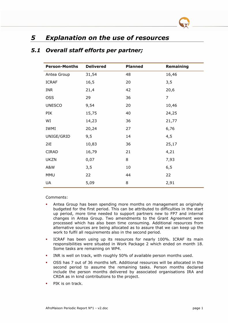
AfroMaison Periodic Report N°1 - v2.doc page 1
5 Explanation on the use of resources
5.1 Overall staff efforts per partner;
Person-Months Delivered Planned Remaining
Antea Group 31,54 48 16,46
ICRAF 16,5 20 3,5
INR 21,4 42 20,6
OSS 29 36 7
UNESCO 9,54 20 10,46
PIK 15,75 40 24,25
WI 14,23 36 21,77
IWMI 20,24 27 6,76
UNIGE/GRID 9,5 14 4,5
2iE 10,83 36 25,17
CIRAD 16,79 21 4,21
UKZN 0,07 8 7,93
A&W 3,5 10 6,5
MMU 22 44 22
UA 5,09 8 2,91
Comments:
� Antea Group has been spending more months on management as originally budgeted for the first period. This can be attributed to difficulties in the start up period, more time needed to support partners new to FP7 and internal changes in Antea Group. Two amendments to the Grant Agreement were processed which has also been time consuming. Additional resources from alternative sources are being allocated as to assure that we can keep up the work to fulfil all requirements also in the second period.
� ICRAF has been using up its resources for nearly 100%. ICRAF its main responsibilities were situated in Work Package 2 which ended on month 18. Some tasks are remaining on WP4.
� INR is well on track, with roughly 50% of available person months used.
� OSS has 7 out of 36 months left. Additional resources will be allocated in the second period to assume the remaining tasks. Person months declared include the person months delivered by associated organisations IRA and CRDA as in kind contributions to the project.
� PIK is on track.

� WI is on track. The political troubles in Mali as well as staff changes in the head-office have caused some delays which is reflected in an relatively underspending of the available person months.
� IWMI, similar as to OSS, has been spending a large number of person month compared to the total available. IWMI is however committed to fulfil it’s remaining responsibilities until the end of the project and is allocating additional resources for this purpose.
� 2iE, similar as to WI, has been spending less person months as planned in the first period. This can also be attributed by the political situation in Mali.
� CIRAD, similar as to IWMI, has relatively few months left. Given the key role in the project as leader of Work Package 7, CIRAD and third parties are highly committed to the project and are allocating staff and alternative resources to keep up the work in the second period.
� UKZN has spend only 0,7 months of its 8 months available. This is due to a shift in tasks between UKZN and INR. This shift in tasks and budget has been introduced in the second request for amendment of the grant agreement.
� A&W is also mainly involved in the Mali case study and similar to WI and 2iE has therefore been spending less person month in the first period. Work in the Mali case study is speeding up. Involved partners have resumed all activities and will deliver all tasks as set out in the description of work.
� MMU is on track having spend 50% of its available person months.
� UA has 2.9 out of 8 person months remaining. The main tasks have been performed in the first period and some additional resources are being allocated to provide support on specific assignments in the project.
5.2 The overall expenditure
Balance RTD MGT OTH TOTAL Requested EU
Contribution
Total 2.977.079,00 258.800,00 911.190,00 4.147.069,00 3.344.998,00
Actual (M1-M18)
1.473.172,52 132.749,20 402.877,08 2.008.798,79 1.617.608,34
Balance 1.503.906,48 126.050,80 508.312,92 2.138.270,21 1.727.389,66
The overall expenditure of AfroMaison budget half way through the project (M1-M18) is very well balanced regarding the total budget.
Out of the 17 partners working on the project, only 3 have gone beyond their budget for personnel costs, and these are CIRAD and Irstea, that are not financially dependent on the project to cover their staff salaries, and ICRAF that is mainly participating for WP2, which is ended at month 18.
Apart from this, there have been two budget shifts, one in South Africa from UKZN to INR, requested in Amendment n° 2, and another in The Netherlands, where WI has transferred some budget to A&W due to the political unrest going on in Mali which has made working in the Inner Niger Delta area difficult.

AfroMaison Periodic Report N°1 - v2.doc page 3
The conflict in Mali have also disturbed the planned work of IRD (third party to CIRAD), as has been reflected in the little budget they have spent in this period. A redistribution of tasks and budget between CIRAD and third parties IRD and IRSTEA has been proposed and will be included in a new request for amendment.
5.3 Conclusion
The project is on track and resources are being spend efficiently. We have achieved a good balance between the allocation of resources over time and can show a good ratio in the progress of work against resources used in the first period.

REFERENCES
Allen, C. R. and L. H. Gunderson (2011). "Pathology and failure in the design and implementation of adaptive management." Journal of Environmental Management 92(5): 1379-1384.
Cook, B. R. and C. J. Spray (2012). "Ecosystem services and integrated water resource management: Different paths to the same end?" Journal of Environmental Management 109: 93-100.
Douthwaite, B., J. M. Ekboir, et al. (2005). The concept of integrated natural resource management (INRM) and its implications for developing evaluation methods. Cambridge, Cabi Publishing.
Fisher, B., R. K. Turner, et al. (2009). "Defining and classifying ecosystem services for decision making." Ecological Economics 68(3): 643-653.
Gottret, M. V. and D. C. White (2002). "Assessing the Impact of Integrated Natural Resource Management: Challenges and Experiences." Ecology and Society 5(2).
Maloti Drakensberg Transfrontier Project (2007) Payment for Ecosystem Services: Developing an Ecosystem Services Trading Model for the Mnweni/Cathedral Peak and Eastern Cape Drakensberg Areas. Mander (Ed) INR Report IR281. Development Bank of Southern Africa, Department of Water Affairs and Forestry, Department of Environment Affairs and Tourism, Ezemvelo KZN Wildlife, South Africa.
Merrey, D. J. (2008). "Is normative integrated water resources management implementable? Charting a practical course with lessons from Southern Africa." Physics and Chemistry of the Earth, Parts A/B/C 33(8–13): 899-905.
Norgaard, R. B. (2010). "Ecosystem services: From eye-opening metaphor to complexity blinder." Ecological Economics 69(6): 1219-1227.
Wetlands Management Department, Ministry of Water and Environment, Uganda; Uganda Bureau of Statistics; International Livestock Research Institute; and World Resources Institute. 2009. Mapping a Better Future: How Spatial Analysis Can Benefi t Wetlands and Reduce Poverty in Uganda. Washington, DC and Kampala: World Resources Institute.
Yalew, S., Teferi, E., van Griensven, A., Uhlenbrook, S., Mul, M., van der Zaag, P., 2012. Land use change and suitability assessment in the Upper Blue Nile basin under water resources and socio-economic constraints: a drive towards a decision support system. International Environmental Modelling and Software Society (iEMSs). 2012 International Congress on Environmental Modelling and Software. Managing Resources of a Limited Planet, Sixth Biennial Meeting, Leipzig, Germany. R. Seppelt, A.A. Voinov, S. Lange, D. Bankamp (Eds.). http://www.iemss.org/society/index.php/ iemss-2012-proceedings.
Zwarts, L., P. van Beukering, B. Kone & E. Wymenga (eds.) 2005. The Niger, a lifeline. Effective water management in the Upper Niger Basin. RIZA, Lelystad / Wetlands International, Sévaré / Institute for Environmental studies (IVM), Amsterdam / A&W ecological consultants, Veenwouden. Mali / the Netherlands.