PROJECT NAME: IWMP - I SHIRUR - WDD-GOKwatershed.kar.nic.in/IWMP_DPR_BATCH1_files/Bagalkot.pdf ·...
38
GOVERNAMENT OF KARNATAKA WATERSHED DEVELOPMENT DEPARTMENT & ZILLA PANCHAYATH BAGALKOT INTEGRATED WATERSHED MANAGEMENT PROGRAMME INTEGRATED WATERSHED MANAGEMENT PROGRAMME INTEGRATED WATERSHED MANAGEMENT PROGRAMME INTEGRATED WATERSHED MANAGEMENT PROGRAMME (2009-10) DETAILED DETAILED DETAILED DETAILED PROJECT PROJECT PROJECT PROJECT REPO REPO REPO REPORT RT RT RT PROJECT NAME: IWMP - I SHIRUR (2009-10 TO 2013-14) TALUK: BAGALKOT BAGALKOT BAGALKOT BAGALKOT DISTRICT: BAGALKOT
Transcript of PROJECT NAME: IWMP - I SHIRUR - WDD-GOKwatershed.kar.nic.in/IWMP_DPR_BATCH1_files/Bagalkot.pdf ·...
GOVERNAMENT OF KARNATAKA
WATERSHED DEVELOPMENT DEPARTMENT & ZILLA PANCHAYATH BAGALKOT
INTEGRATED WATERSHED MANAGEMENT PROGRAMMEINTEGRATED WATERSHED MANAGEMENT PROGRAMMEINTEGRATED WATERSHED MANAGEMENT PROGRAMMEINTEGRATED WATERSHED MANAGEMENT PROGRAMME
(2009-10)
DETAILEDDETAILEDDETAILEDDETAILED PROJECTPROJECTPROJECTPROJECT REPOREPOREPOREPORTRTRTRT
PROJECT NAME: IWMP - I SHIRUR
(2009-10 TO 2013-14)
TALUK: BAGALKOTBAGALKOTBAGALKOTBAGALKOT DISTRICT: BAGALKOT
Table of Content
Chapter Content Page
Executive Summary
1 Introduction and Background
2 General Description of Project Area
3 Baseline Survey
4 Institution Building and Project Management
5 Management/Action Plan
6 Capacity Building Plan
7 Phasing of Programme and Budgeting
8 Consolidation Exit Strategy
9 Expected Outcome
Executive SummaryExecutive SummaryExecutive SummaryExecutive Summary
* Brief about area:
The SHIRUR IWMPSHIRUR IWMPSHIRUR IWMPSHIRUR IWMP----IIII watershed having code numbers 4D7C2I1a, 4D7C2I1b, 4D7C2I1d, 4D7C2I1e, 4D7C2I1f and area comes under northern dry climatic zone. This watershed covers One villages under the One gram panchayats. Average rain fall of this area is 559mm and soil types of both black and red. The total geographical area of watershed is 3624.50ha and this area comes under bagalkot Taluk of Bagalkot district. Major crops are rabi jowar, sun flower, bajra and bengal gram. Majorly we find monocropping with mixed cropping pattern. This watershed is characterised by hilly undulating area leading to high soil erosion, low productivity and lack of irrigation, safe drinking water facility & migration in seeking of employment. IWMP aims at improving the situation of the area during the project period 2009-10 to 2013-14, and this scheme is prioritized to mitigate the existing parameters like poverty, productivity of the soil, migration, degraded land etc. Based on these parameters a composite point of IWMP-I SHIRUR watershed project as given in the table.
• Institutional arrangements:
WDT of watershed development department is the project implementing agency in Shirur IWMP-I. The project would be implemented through the promoted CBO’s during the project period. Commonly known CBO’s are SHG’s, UG’s & WC’s. Totally 25 SHG’s, 25 UG’s formed in one villages. At Gram panchayath level one watershed committees has been formed. over all more than 80% of families coming under watershed area are going to take part and contribute in the watershed programmes in various institutional form.
• Salient Project activities:
Considering the context, base line data analyses, PRA exercises, net planning, EPA, natural resource management plan, livelihood development plan, productivity enhancement plan & capacity building plan has been prepared.
Major proposed activities under EPA’s are construction of check dam, & percolation tank will comes and which would cost
4% of the whole budget i. e, 494.25. under agriculture sector, soil and water conservation & drainage line treatment comes with the budget allocation of 60.85% i.e. 180.65lakhs, Horticulture sector allocation of 17.55% of the works components i,e, 52.11lakhs, Agro Forestry sector allocation of 18.46%i.e. 54.81lakhs and live stock sector allocation of 3.13% i,e 9.3lakhs. Administrative cost is 10% of the total budget i,e 49.425lakhs, monitoring and evaluation is 2% i,e 9.885lakhs, capacity building & community organization is 5% i,e 24.7125lakhs detail project report preparation is 1% i,e 4.94lakhs livelihood support, micro entrepreneurship & production systems is 15% of the total budget i.e. 74.1375lakhs and consolidation & withdrawal phase is 3% i.e14.8275lakhs.
A comprehensive training & capacity building plan covering 3026 families would capacitated during the project period (2009-
10 to 2013-14) the entire proposed plan would be implemented through watershed committees in close co-ordination with CBO’s &
local communityA comprehensive training & capacity building plan covering 3186 families would capacitated during the project
period (2009-10 to 2013-14) the entire proposed plan would be implemented through watershed committees in close co-ordination
with CBO’s & local community.
• Physical target and financial outlays:
In private land SWC activates like Bunding- 2.27lakh RMT, RC/BC and form pond construction etc –148.73lakhs under Horticulture sector 80961no’s of planting material’s planting and bund sowing of 1.51lakh RMT- with the budget of Rs 50.63lakhs under Forest sector planting material’s planting and seed sowing on the bunds is 1406ha with the budget of Rs 36.98lakhs under Live stock sector 15ha perennial grasses, 8ha crop border plantation of fodder and growing perennial fodder on bunds - with the budget of Rs 9.28lakhs In common land
Under horticulture sector planting material’s planting –Rs. 1.36lakhs. Under forest sector planting – 2.94lakhs.
In drainage land treatments 6 no’s CD, RC/BC construction -31.92lakhs
Under horticulture sector planting -0.11lakhs Under forest sector planting,
183ha seed sowing on bund and agave planting -14.9lakhs
• Treatment area and details:
Among the total area of the project 3624.50ha, the area available for treatment is 3295ha. The project duration is 2009-10 to
2013-14. In the treatable area arable land, non arable land, drainage line treatment, horticulture planting, forest planting, live
stock programmes and common property resource development are included. Here ridge to valley watershed concept is adopted.
Criteria for selection watershed are Criteria for selection watershed are Criteria for selection watershed are Criteria for selection watershed are
� Poverty index is above 80%.
� Actual ground water level is bellow & minimum.
� Small and marginal formers are more.
� Less than 20% area under assured irrigation.
• Fact sheet about bench mark indicators and action plan a glance
Land use pattern is based on rainfall; average loss of soil is due to water erosion about 81/ha/year. Different types soil mainly red and medium black. The average 559mm rainfall with uneven distribution of rain days leads to soil erosion, poor vegetative cover, nutrient losses and decreasing ground water table rapid deforestation, lands are unbunded less dirking water facility. The intervention of watershed activities/programmes to control of the soil erosion, maximum water harvesting, minimum erosion and to maintain increases productivity of crops and lands.
ACTION PLAN A GLANCEACTION PLAN A GLANCEACTION PLAN A GLANCEACTION PLAN A GLANCE
1 First you discuss in district & Taluka level net planning workshop. 2 Conduct the meetings in field level at project office including EC, SHG, & UG members 3 Form the two teams for net planning serve, field transact & data collection 4 Rough action plan 5 Computerised the collected net planning data’s 6 Conduct the gram Sabah regarding approval of action plan 7 Conduct the PRA exercise 8 Take technical approval from all the sectarial head and DWDO 9 Take financial approval from CEO ZP Bagalkot In the district level committee
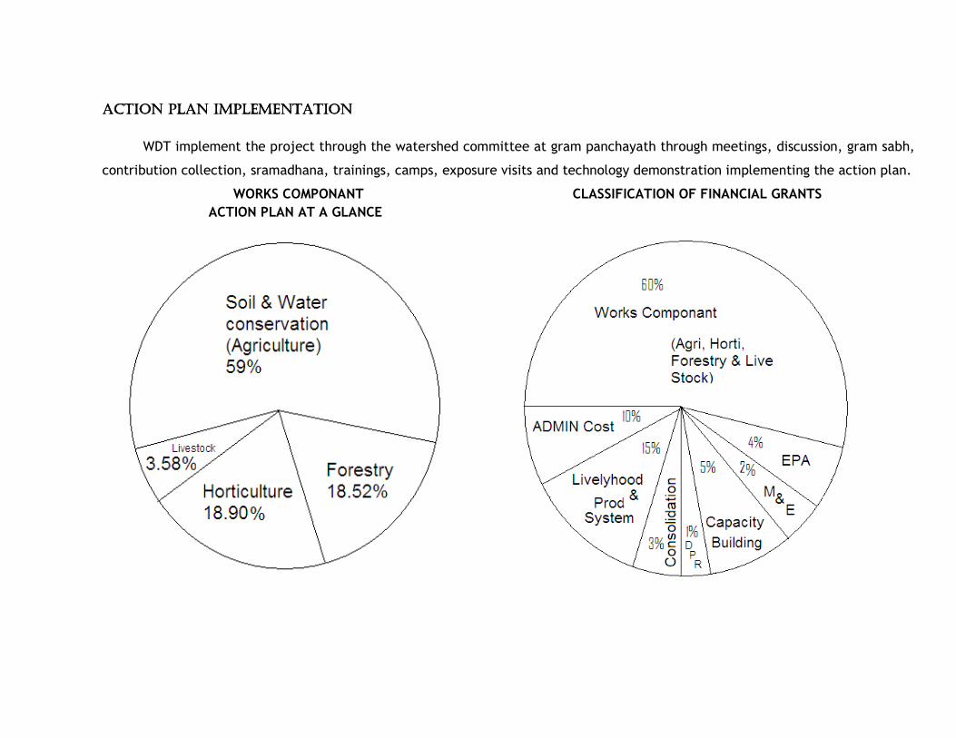
ACTION PLAN IMPLEMENTATION ACTION PLAN IMPLEMENTATION ACTION PLAN IMPLEMENTATION ACTION PLAN IMPLEMENTATION
WDT implement the project through the watershed committee at gram panchayath through meetings, discussion, gram sabh,
contribution collection, sramadhana, trainings, camps, exposure visits and technology demonstration implementing the action plan.
WORKS COMPONANT CLASSIFICATION OF FINANCIAL GRANTS
ACTION PLAN AT A GLANCE
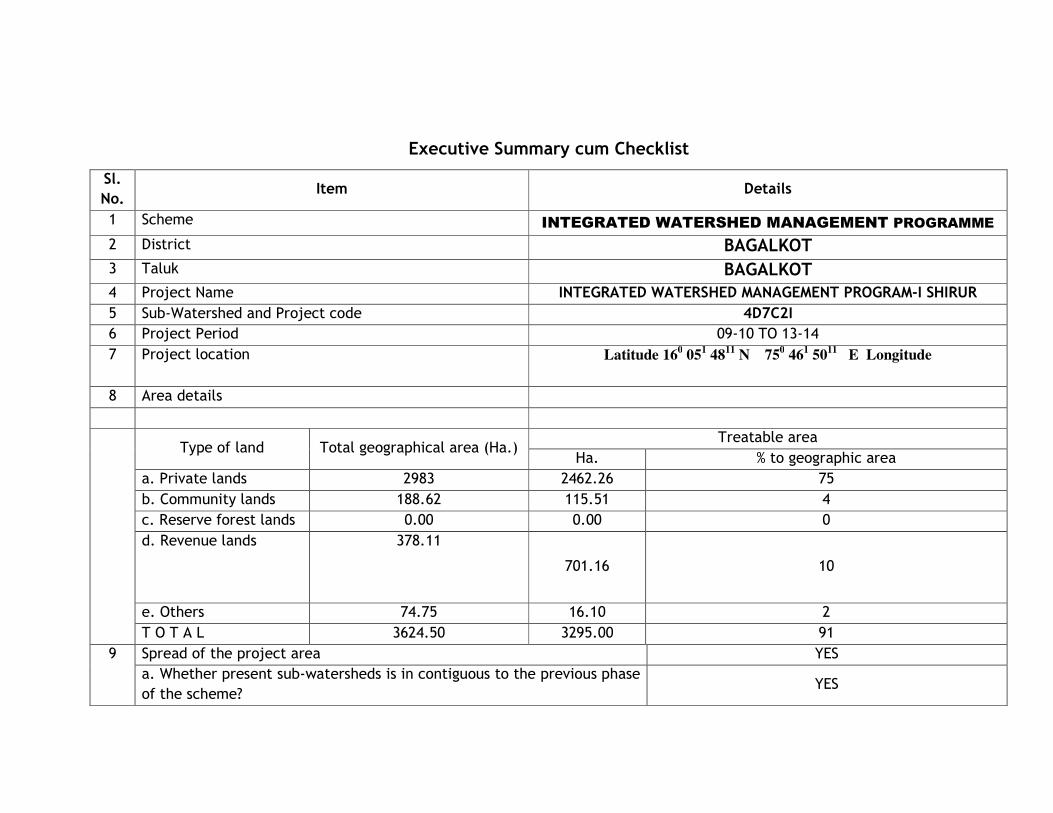
Executive Summary cum Checklist
Sl.
No. Item Details
1 Scheme INTEGRATED WATERSHED MANAGEMENT PROGRAMME
2 District BAGALKOT
3 Taluk BAGALKOT
4 Project Name INTEGRATED WATERSHED MANAGEMENT PROGRAM-I SHIRUR 5 Sub-Watershed and Project code 4D7C2I 6 Project Period 09-10 TO 13-14
7 Project location Latitude 160 05
1 48
11 N 75
0 46
1 50
11 E Longitude
8 Area details
Type of land Total geographical area (Ha.)
Treatable area
Ha. % to geographic area
a. Private lands 2983 2462.26 75
b. Community lands 188.62 115.51 4
c. Reserve forest lands 0.00 0.00 0
d. Revenue lands 378.11
701.16 10
e. Others 74.75 16.10 2
T O T A L 3624.50 3295.00 91
9 Spread of the project area YES
a. Whether present sub-watersheds is in contiguous to the previous phase
of the scheme? YES

Sl.
No. Item Details
b. Does the Project follow the priority fixed in the perspective plan for
watershed development in the district? NO
10 Site specific objectives of the project if any (other than general
objectives)
No specific objectives
11 Name of the project implementing agency TWDO, BAGALKOT
12 Name of the agency associated with the preparation/ implementation of
the plan WDD / NGOWDD / NGOWDD / NGOWDD / NGO
13 Name of the persons and designations who are
associated with the net/gross planning exercise of the
project
1. 1. 1. 1. SHRI: T.R.PATILSHRI: T.R.PATILSHRI: T.R.PATILSHRI: T.R.PATIL TWDO TWDO TWDO TWDO BAGALKOT
2. 2. 2. 2. SHRI: S.S.PATILSHRI: S.S.PATILSHRI: S.S.PATILSHRI: S.S.PATIL AAOAAOAAOAAO BAGALKOT
3. SHRI: MULLA 3. SHRI: MULLA 3. SHRI: MULLA 3. SHRI: MULLA AAO AAO AAO AAO BAGALKOT
4. SHRI; 4. SHRI; 4. SHRI; 4. SHRI; PAWAR PAWAR PAWAR PAWAR AHAHAHAHOOOO BAGALKOT
5. SHRI: RAJESHAB 5. SHRI: RAJESHAB 5. SHRI: RAJESHAB 5. SHRI: RAJESHAB RFO RFO RFO RFO BAGALKOT
6.SHRI: S B SANAMANI 6.SHRI: S B SANAMANI 6.SHRI: S B SANAMANI 6.SHRI: S B SANAMANI AA AA AA AA BAGALKOT
7. A. H. INGALAGI 7. A. H. INGALAGI 7. A. H. INGALAGI 7. A. H. INGALAGI TEAM LEADERTEAM LEADERTEAM LEADERTEAM LEADER SHIRUR
14 Whether PRA was conducted at the time of preparing
the net/gross plan and if yes, details
Yes / GP wise details
YES
15-05-2011
Sl.
No. Item Details
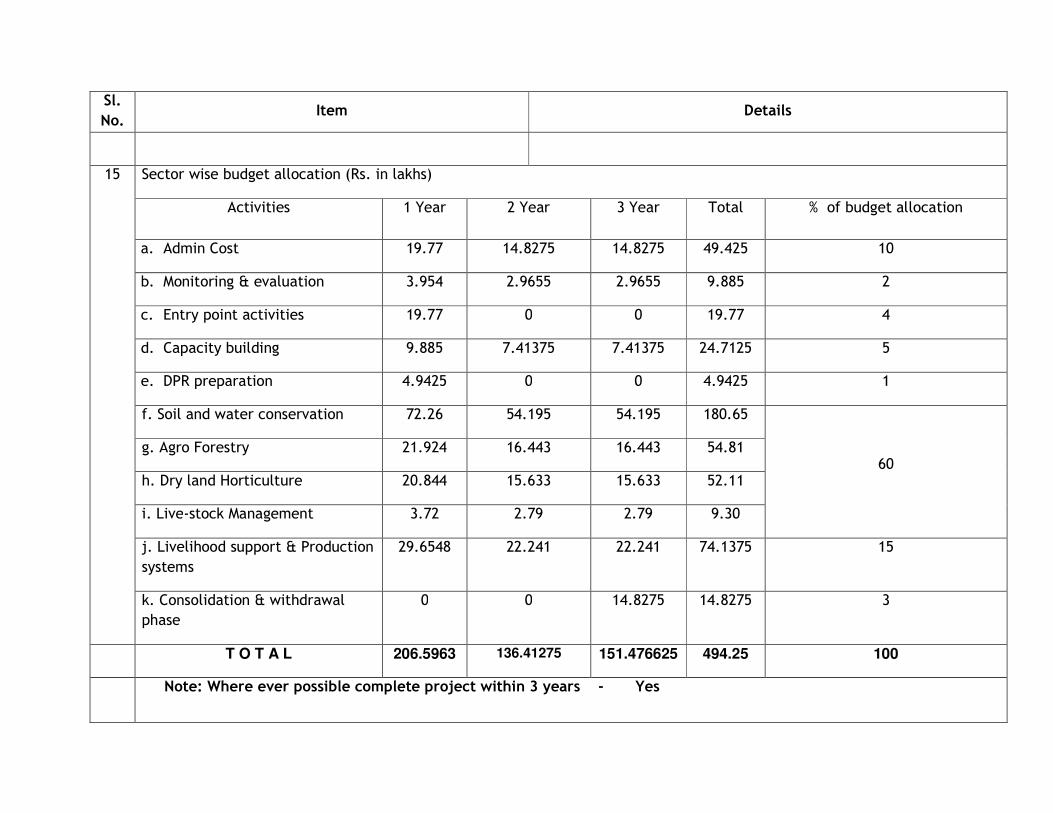
15 Sector wise budget allocation (Rs. in lakhs)
Activities 1 Year 2 Year 3 Year Total % of budget allocation
a. Admin Cost 19.77 14.8275 14.8275 49.425 10
b. Monitoring & evaluation 3.954 2.9655 2.9655 9.885 2
c. Entry point activities 19.77 0 0 19.77 4
d. Capacity building 9.885 7.41375 7.41375 24.7125 5
e. DPR preparation 4.9425 0 0 4.9425 1
f. Soil and water conservation 72.26 54.195 54.195 180.65
60 g. Agro Forestry 21.924 16.443 16.443 54.81
h. Dry land Horticulture 20.844 15.633 15.633 52.11
i. Live-stock Management 3.72 2.79 2.79 9.30
j. Livelihood support & Production
systems
29.6548 22.241 22.241 74.1375 15
k. Consolidation & withdrawal
phase
0 0 14.8275 14.8275 3
T O T A L 206.5963 136.41275 151.476625 494.25 100
Note: Where ever possible complete project within 3 years - Yes
Sl.
No. Item Details
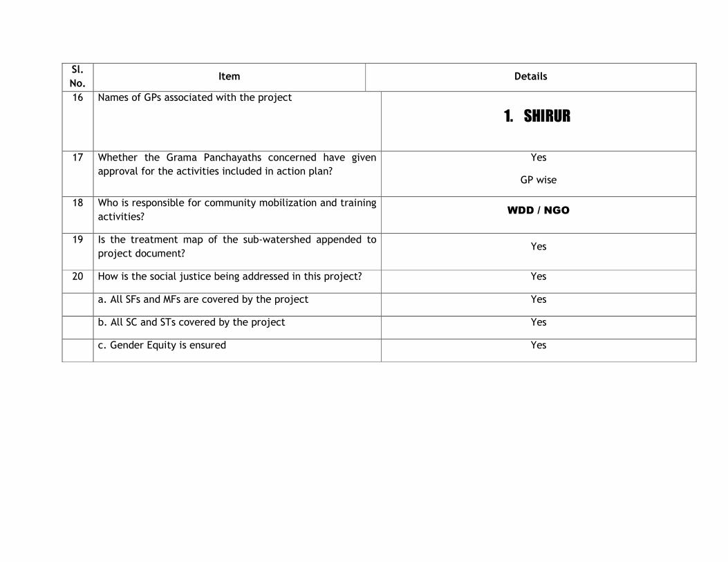
16 Names of GPs associated with the project
1. SHIRUR
17 Whether the Grama Panchayaths concerned have given
approval for the activities included in action plan?
Yes
GP wise
18 Who is responsible for community mobilization and training
activities? WDD / NGO
19 Is the treatment map of the sub-watershed appended to
project document? Yes
20 How is the social justice being addressed in this project? Yes
a. All SFs and MFs are covered by the project Yes
b. All SC and STs covered by the project Yes
c. Gender Equity is ensured Yes
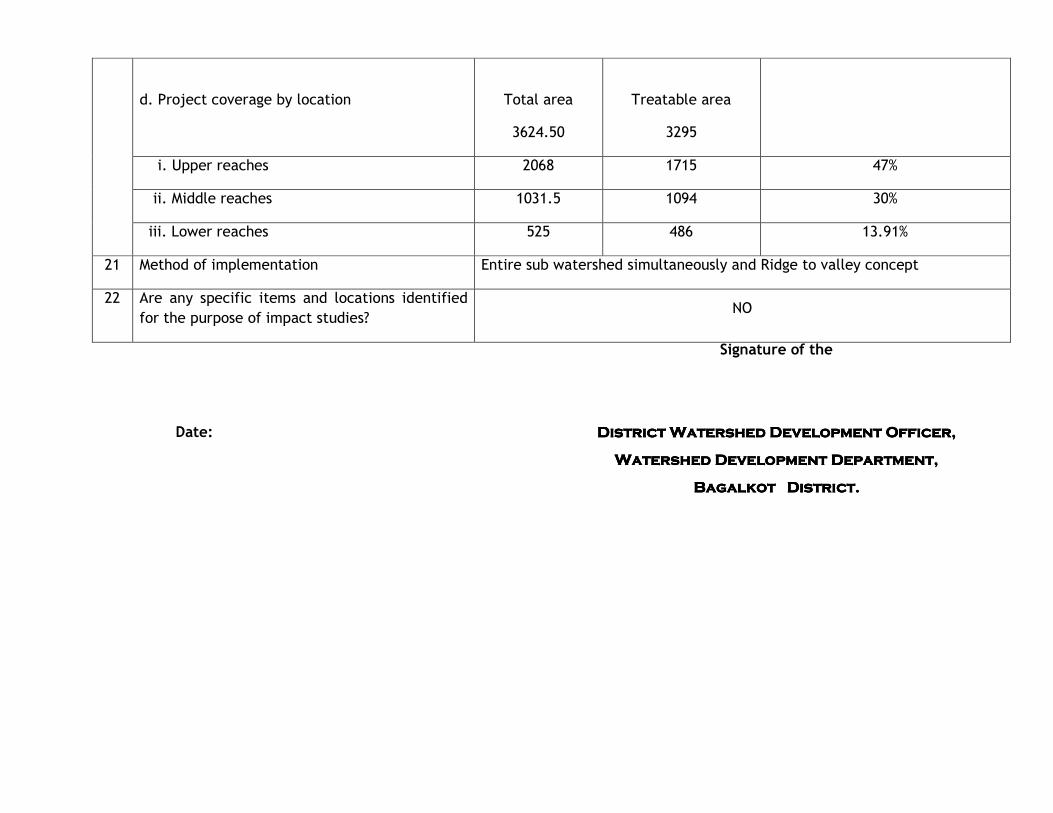
Date:
Signature of the
District Watershed Development Officer,District Watershed Development Officer,District Watershed Development Officer,District Watershed Development Officer,
Watershed Development Department,Watershed Development Department,Watershed Development Department,Watershed Development Department,
Bagalkot District.Bagalkot District.Bagalkot District.Bagalkot District.
d. Project coverage by location
Total area
3624.50
Treatable area
3295
i. Upper reaches 2068 1715 47%
ii. Middle reaches 1031.5 1094 30%
iii. Lower reaches 525 486 13.91%
21 Method of implementation Entire sub watershed simultaneously and Ridge to valley concept
22 Are any specific items and locations identified
for the purpose of impact studies? NO
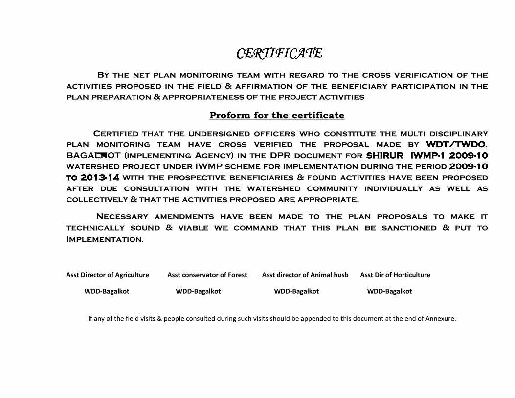
CERTIFICATECERTIFICATECERTIFICATECERTIFICATE
By the net plan monitoring team with regard to the cross verification of the
activities proposed in the field & affirmation of the beneficiary participation in the
plan preparation & appropriateness of the project activities
Proform for the certificate
Certified that the undersigned officers who constitute the multi disciplinary
plan monitoring team have cross verified the proposal made by WDT/TWDOWDT/TWDOWDT/TWDOWDT/TWDO,
BAGALKOT (implementing Agency) in the DPR document for SHIRUR IWMPSHIRUR IWMPSHIRUR IWMPSHIRUR IWMP----1111 2009200920092009----10 10 10 10
watershed project under IWMP scheme for Implementation during the period 2009200920092009----10 10 10 10
to 2013to 2013to 2013to 2013----14141414 with the prospective beneficiaries & found activities have been proposed
after due consultation with the watershed community individually as well as
collectively & that the activities proposed are appropriate.
Necessary amendments have been made to the plan proposals to make it
technically sound & viable we command that this plan be sanctioned & put to
Implementation.
Asst Director of Agriculture Asst conservator of Forest Asst director of Animal husb Asst Dir of Horticulture
WDD-Bagalkot WDD-Bagalkot WDD-Bagalkot WDD-Bagalkot
If any of the field visits & people consulted during such visits should be appended to this document at the end of Annexure.
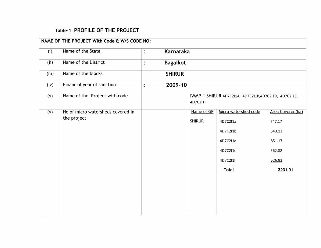
Table-1: PROFILE OF THE PROJECT
NAME OF THE PROJECT With Code & W/S CODE NO:
(i) Name of the State : Karnataka
(ii) Name of the District : Bagalkot
(iii) Name of the blocks SHIRUR
(iv) Financial year of sanction : 2009-10
(v) Name of the Project with code IWMP-1 SHIRUR 4D7C2I1A, 4D7C2I1B,4D7C2I1D, 4D7C2I1E,
4D7C2I1F.
(v) No of micro watersheds covered in
the project
Name of GP
SHIRUR
Micro watershed code Area Covered(ha)
4D7C2I1a 747.17
4D7C2I1b 543.13
4D7C2I1d 851.17
4D7C2I1e 562.82
4D7C2I1f 526.82
Total 3231.91
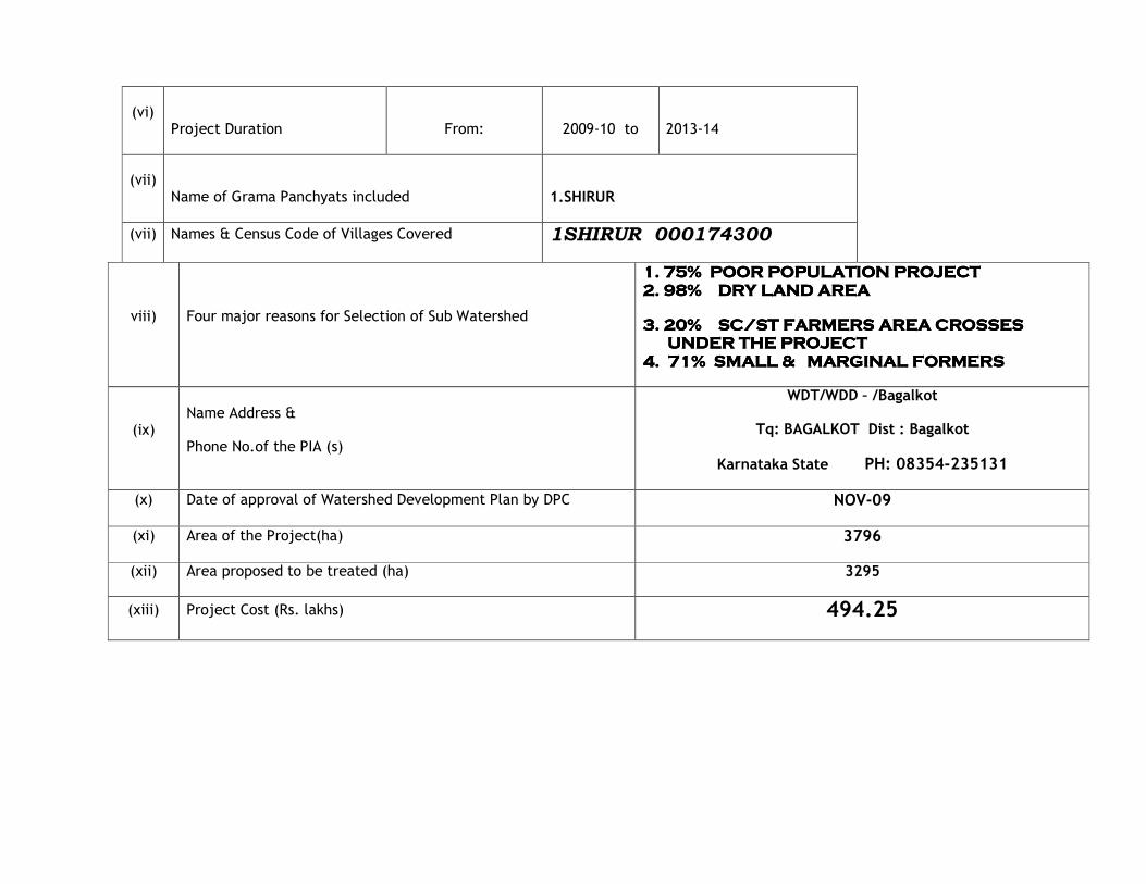
(vi)
Project Duration
From:
2009-10 to
2013-14
(vii)
Name of Grama Panchyats included
1.SHIRUR
(vii) Names & Census Code of Villages Covered 1SHIRUR 000174300
viii) Four major reasons for Selection of Sub Watershed
1. 75% POOR POPULATION PROJECT1. 75% POOR POPULATION PROJECT1. 75% POOR POPULATION PROJECT1. 75% POOR POPULATION PROJECT
2. 98% DRY LAND AREA2. 98% DRY LAND AREA2. 98% DRY LAND AREA2. 98% DRY LAND AREA
3. 20% SC/ST FARMERS AREA CROSSES 3. 20% SC/ST FARMERS AREA CROSSES 3. 20% SC/ST FARMERS AREA CROSSES 3. 20% SC/ST FARMERS AREA CROSSES UNDER THE PROJECTUNDER THE PROJECTUNDER THE PROJECTUNDER THE PROJECT
4. 71% SMALL & MARGINAL FORMERS4. 71% SMALL & MARGINAL FORMERS4. 71% SMALL & MARGINAL FORMERS4. 71% SMALL & MARGINAL FORMERS
(ix) Name Address &
Phone No.of the PIA (s)
WDT/WDD – /Bagalkot
Tq: BAGALKOT Dist : Bagalkot
Karnataka State PH: 08354-235131
(x) Date of approval of Watershed Development Plan by DPC NOV-09
(xi) Area of the Project(ha) 3796
(xii) Area proposed to be treated (ha) 3295
(xiii) Project Cost (Rs. lakhs) 494.25
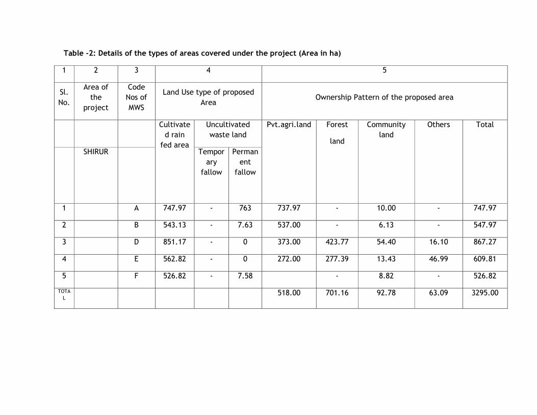
Table -2: Details of the types of areas covered under the project (Area in ha)
1 2 3 4 5
Sl.
No.
Area of
the
project
Code
Nos of
MWS
Land Use type of proposed
Area Ownership Pattern of the proposed area
Cultivate
d rain
fed area
Uncultivated
waste land
Pvt.agri.land Forest
land
Community
land
Others Total
SHIRUR Tempor
ary
fallow
Perman
ent
fallow
1 A 747.97 - 763 737.97 - 10.00 - 747.97
2 B 543.13 - 7.63 537.00 - 6.13 - 547.97
3 D 851.17 - 0 373.00 423.77 54.40 16.10 867.27
4 E 562.82 - 0 272.00 277.39 13.43 46.99 609.81
5 F 526.82 - 7.58 - 8.82 - 526.82
TOTA
L 518.00 701.16 92.78 63.09 3295.00

Table -3: Details of the types of areas covered under the project (Area in ha)
1 2 3 4 5
Sl.
No.
Area of the
project
Code Nos of
MWS No.of Beneficiaries Covered
Identified DPAP/DDP Blocks
Covered
MF SF LF
Landle
ss Total
DPAP DDP
No.of blocks Area No.of blocks Area
1
3295 HA
SHIRUR 145 188 112 89 534 0 0 1 747.97
2 SHIRUR 44 172 97 103 416 - - - 543.13
3 SHIRUR 142 90 56 229 517 - - - 867.27
4 SHIRUR 308 76 25 132 541 - - - 609.81
5 SHIRUR 130 142 69 156 497 0 0 1 526.82
Total
769
668
349
709
2505
3295.0
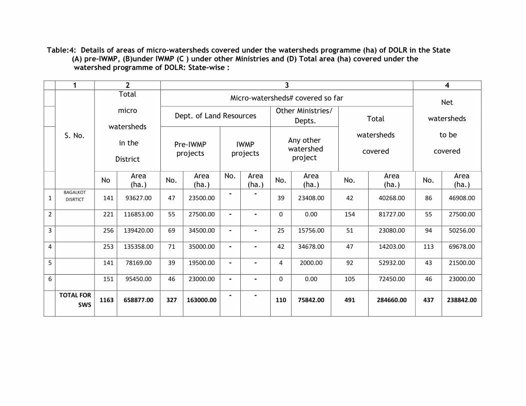
Table:4: Details of areas of micro-watersheds covered under the watersheds programme (ha) of DOLR in the State (A) pre-IWMP, (B)under IWMP (C ) under other Ministries and (D) Total area (ha) covered under the watershed programme of DOLR: State-wise :
1 2 3 4
S. No.
Total
micro
watersheds
in the
District
Micro-watersheds# covered so far Net
watersheds
to be
covered
Dept. of Land Resources
Other Ministries/
Depts. Total
watersheds
covered
Pre-IWMP projects
IWMP projects
Any other watershed project
No
Area (ha.)
No. Area (ha.)
No.
Area (ha.)
No. Area (ha.)
No. Area (ha.)
No. Area (ha.)
1 BAGALKOT
DISRTICT 141 93627.00 47 23500.00 - -
39 23408.00 42 40268.00 86 46908.00
2 221 116853.00 55 27500.00 - - 0 0.00 154 81727.00 55 27500.00
3 256 139420.00 69 34500.00 - - 25 15756.00 51 23080.00 94 50256.00
4 253 135358.00 71 35000.00 - - 42 34678.00 47 14203.00 113 69678.00
5 141 78169.00 39 19500.00 - - 4 2000.00 92 52932.00 43 21500.00
6 151 95450.00 46 23000.00 - - 0 0.00 105 72450.00 46 23000.00
TOTAL FOR
SWS 1163 658877.00 327 163000.00
- - 110 75842.00 491 284660.00 437 238842.00
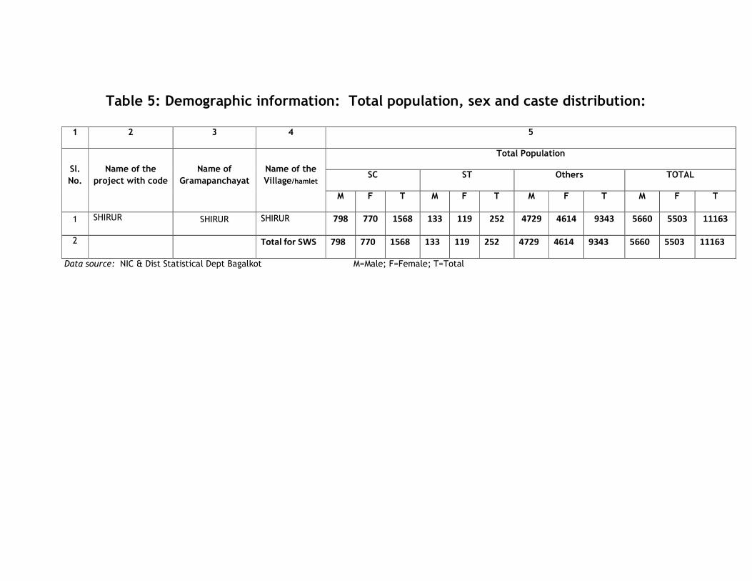
Table 5: Demographic information: Total population, sex and caste distribution:
1 2 3 4 5
Sl.
No.
Name of the
project with code
Name of
Gramapanchayat
Name of the
Village/hamlet
Total Population
SC ST Others TOTAL
M F T M F T M F T M F T
1 SHIRUR SHIRUR SHIRUR 798 770 1568 133 119 252 4729 4614 9343 5660 5503 11163
2 Total for SWS 798 770 1568 133 119 252 4729 4614 9343 5660 5503 11163
Data source: NIC & Dist Statistical Dept Bagalkot M=Male; F=Female; T=Total
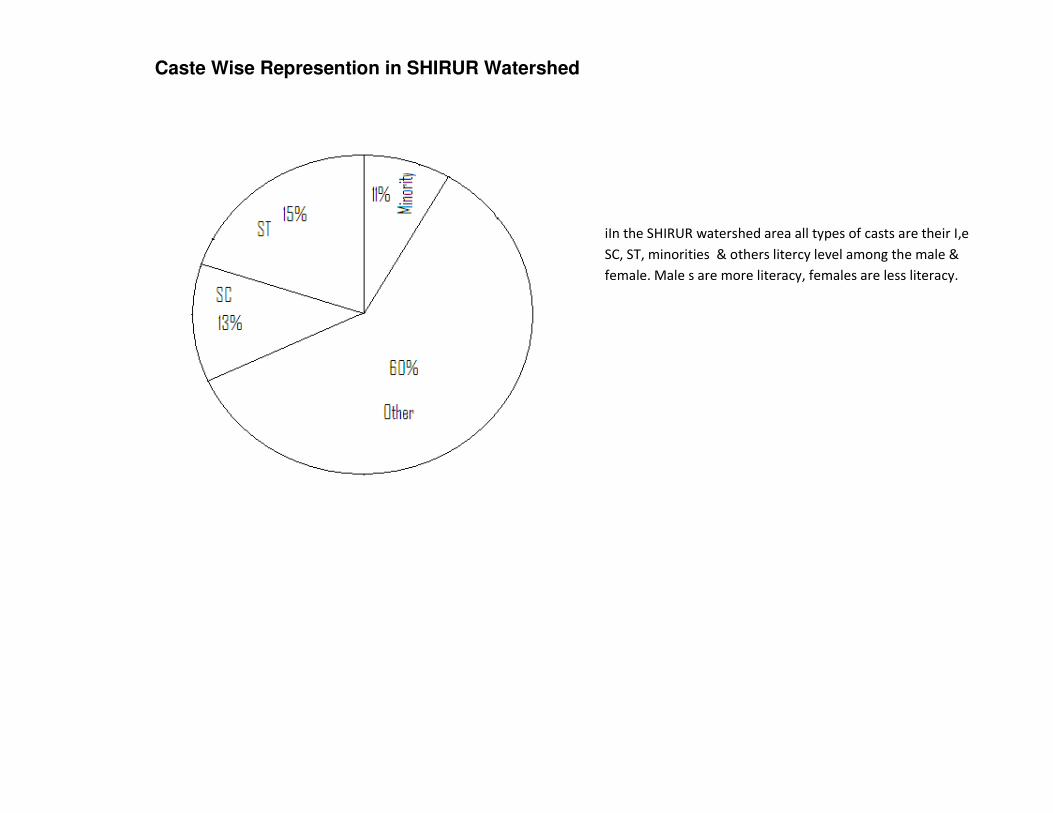
Caste Wise Represention in SHIRUR Watershed
iIn the SHIRUR watershed area all types of casts are their I,e
SC, ST, minorities & others litercy level among the male &
female. Male s are more literacy, females are less literacy.
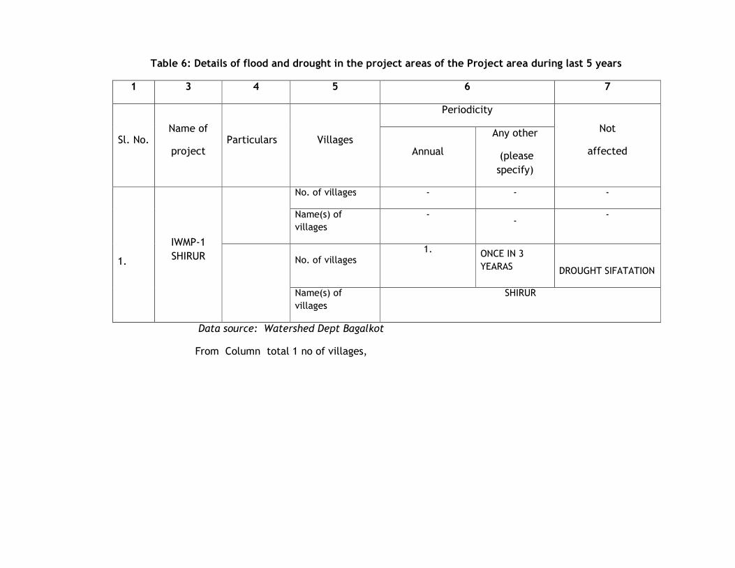
Table 6: Details of flood and drought in the project areas of the Project area during last 5 years
1 3 4 5 6 7
Sl. No. Name of
project Particulars Villages
Periodicity
Not
affected Annual
Any other
(please
specify)
1.
IWMP-1
SHIRUR
No. of villages - - -
Name(s) of
villages
- -
-
No. of villages
1. ONCE IN 3
YEARAS
DROUGHT SIFATATION
Name(s) of
villages
SHIRUR
Data source: Watershed Dept Bagalkot
From Column total 1 no of villages,
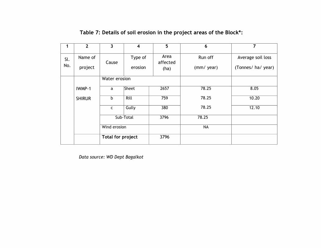
Table 7: Details of soil erosion in the project areas of the Block*:
1 2 3 4 5 6 7
Sl.
No.
Name of
project Cause
Type of
erosion
Area
affected
(ha)
Run off
(mm/ year)
Average soil loss
(Tonnes/ ha/ year)
IWMP-1
SHIRUR
Water erosion
a Sheet 2657 78.25
78.25
78.25
8.05
b Rill 759 10.20
c Gully 380 12.10
Sub-Total 3796 78.25
Wind erosion NA
Total for project 3796
Data source: WD Dept Bagalkot
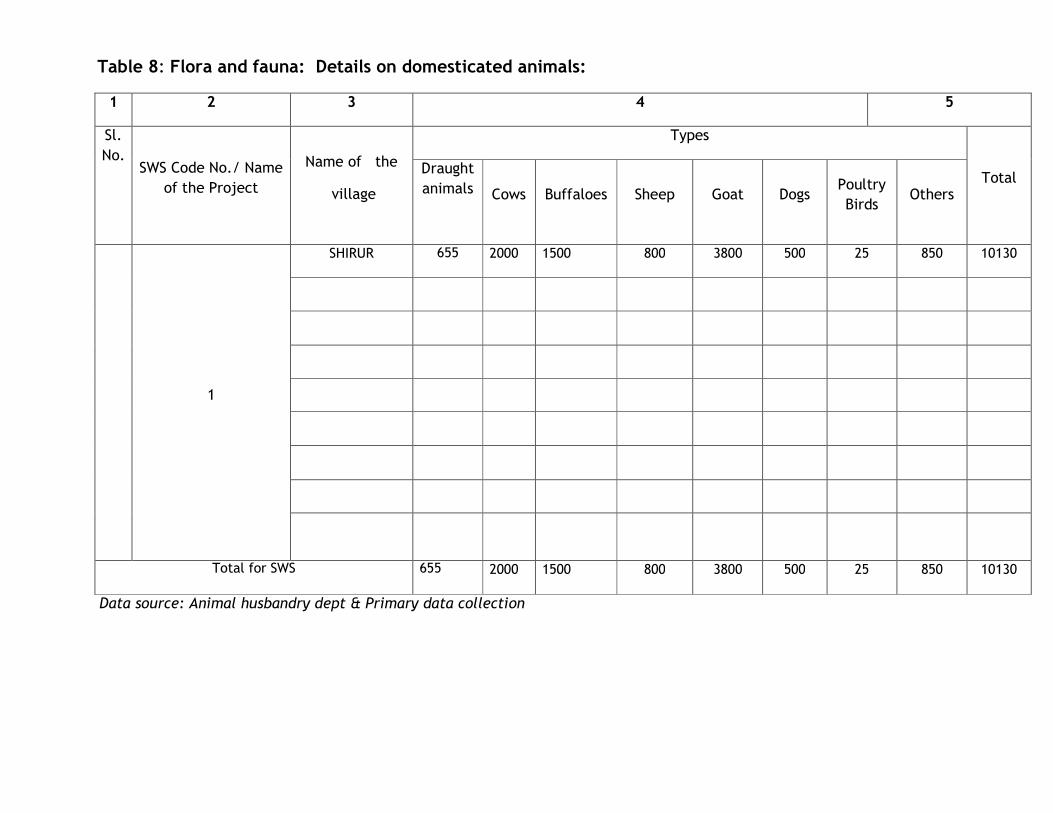
Table 8: Flora and fauna: Details on domesticated animals:
1 2 3 4 5
Sl.
No.
SWS Code No./ Name
of the Project
Name of the
village
Types
Total Draught
animals Cows Buffaloes Sheep Goat Dogs Poultry
Birds Others
1
SHIRUR 655 2000 1500 800 3800 500 25 850 10130
Total for SWS 655 2000 1500 800 3800 500 25 850 10130
Data source: Animal husbandry dept & Primary data collection
Table 9: Details of infrastructure in the project areas in the sub watershed of Block SHIRUR Dist; Bagalkot .
1 2 3 4 5
Sl
No Name of project with SWS code
Parameters Status
1
IWMP -1 SHIRUR
4D7C2I1A
4D7C2I1B
4D7C2I1D
4D7C2I1E
4D7C2I1F
(i)
No. of villages connected to the main road by an all-weather road ONE VILLAGE
CANNECTED TO STATE
HIGHWAY.
2 (ii) No. of villages provided with electricity
ONE
3 (iii) No. of households without access to drinking water 180
4 (iv) No. of educational institutions :
Primary(P)/ Secondary(S)/
Higher Secondary(HS)
/ vocational institution(VI)
(P)
06
(S)
03
(HS)
03
VI)
02
5 (v) No. of villages with access to Primary Health Centre 01 ONE
6 (vi) No. of villages with access to Veterinary Dispensary 01 ONE
7 (vii) No. of villages with access to Post Office 01 ONE
8 (viii) No. of villages with access to Banks 01 ONE
9 (ix) No. of villages with access to Markets/ mandis 01 ONE
10 (X) No. Of milk collection centres -
11 (XI) No. Of PKPS -
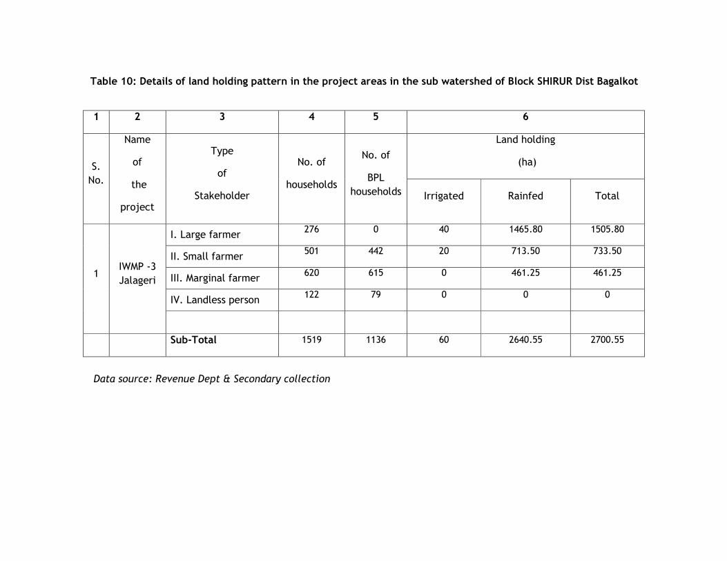
Table 10: Details of land holding pattern in the project areas in the sub watershed of Block SHIRUR Dist Bagalkot
Data source: Revenue Dept & Secondary collection
1 2 3 4 5 6
S.
No.
Name
of
the
project
Type
of
Stakeholder
No. of
households
No. of
BPL
households
Land holding
(ha)
Irrigated Rainfed Total
1 IWMP -3
Jalageri
I. Large farmer 276 0 40 1465.80 1505.80
II. Small farmer 501 442 20 713.50 733.50
III. Marginal farmer 620 615 0 461.25 461.25
IV. Landless person 122 79 0 0 0
Sub-Total 1519 1136 60 2640.55 2700.55
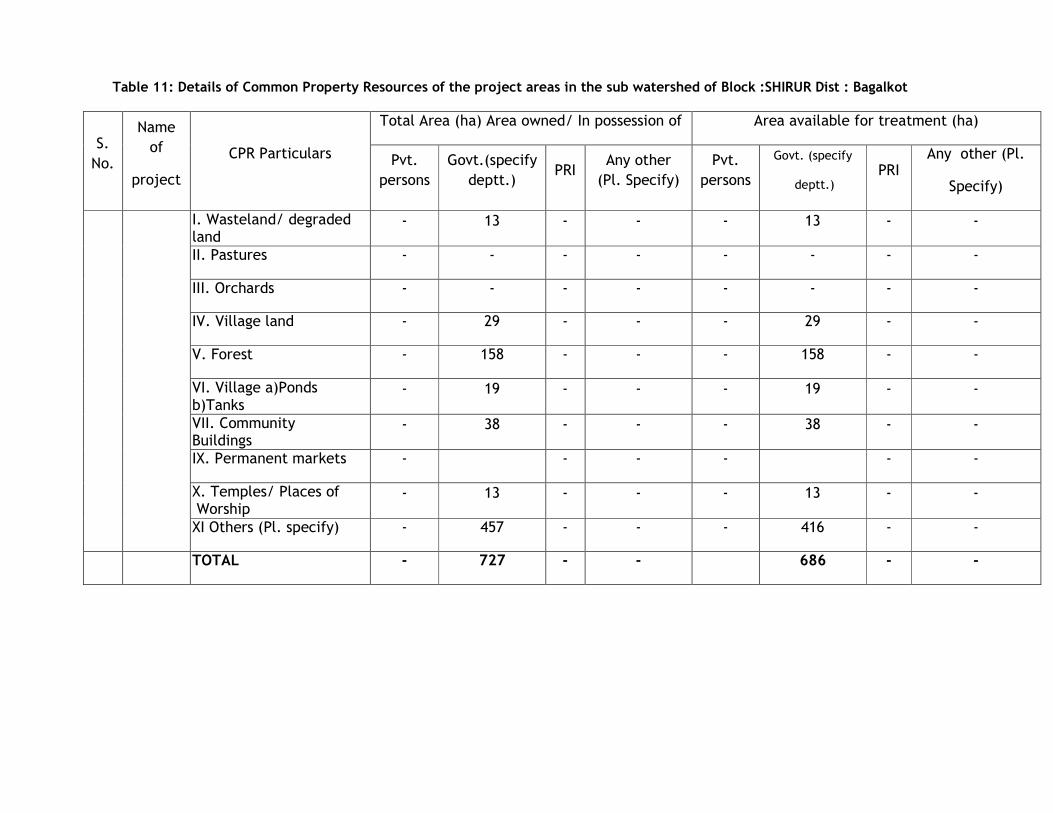
Table 11: Details of Common Property Resources of the project areas in the sub watershed of Block :SHIRUR Dist : Bagalkot
S.
No.
Name
of
project
CPR Particulars
Total Area (ha) Area owned/ In possession of Area available for treatment (ha)
Pvt.
persons
Govt.(specify
deptt.) PRI
Any other
(Pl. Specify)
Pvt.
persons
Govt. (specify
deptt.) PRI
Any other (Pl.
Specify)
I. Wasteland/ degraded land
- 13 - - - 13 - -
II. Pastures - - - - - - - -
III. Orchards - - - - - - - -
IV. Village land - 29 - - - 29 - -
V. Forest - 158 - - - 158 - -
VI. Village a)Ponds b)Tanks
- 19 - - - 19 - -
VII. Community Buildings
- 38 - - - 38 - -
IX. Permanent markets - - - - - -
X. Temples/ Places of Worship
- 13 - - - 13 - -
XI Others (Pl. specify) - 457 - - - 416 - -
TOTAL - 727 - - 686 - -
Table 12: Details of the project implementing agency(s)
1 2
Sl. No. Particulars of PIA
1 Date of Selection of PIA 26-10-2009
2 Type of Organization A
3 Name of Organization WDD
4 Designation and Address TWDO/WDD,BAGALKOT
-587103
5 Telephone 08354-235131
6 Fax 08354-235131
7 E-mail [email protected]
# Only letter assigned to each type, as given below, needs to be typed
A- Line dept., B- Autonomous organization,C- Govt.Institute, D- Research bodies, E- Zilla parishad, F- Intermediate Panchayat,G- Voluntary Organizations, H- Any Other
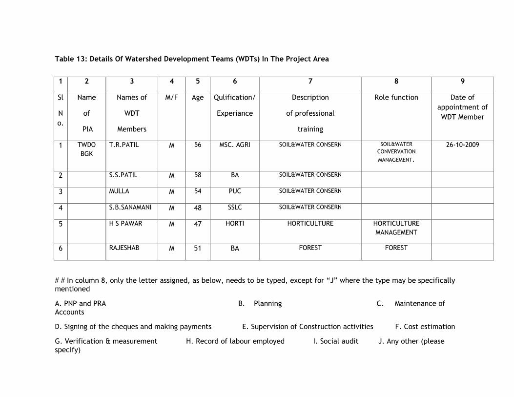
Table 13: Details Of Watershed Development Teams (WDTs) In The Project Area
# # In column 8, only the letter assigned, as below, needs to be typed, except for “J” where the type may be specifically mentioned
A. PNP and PRA B. Planning C. Maintenance of Accounts
D. Signing of the cheques and making payments E. Supervision of Construction activities F. Cost estimation
G. Verification & measurement H. Record of labour employed I. Social audit J. Any other (please specify)
1 2 3 4 5 6 7 8 9
Sl
N
o.
Name
of
PIA
Names of
WDT
Members
M/F Age Qulification/
Experiance
Description
of professional
training
Role function
Date of
appointment of
WDT Member
1 TWDO
BGK
T.R.PATIL M 56 MSC. AGRI SOIL&WATER CONSERN SOIL&WATER
CONVERVATION
MANAGEMENT.
26-10-2009
2 S.S.PATIL M 58 BA SOIL&WATER CONSERN
3 MULLA M 54 PUC SOIL&WATER CONSERN
4 S.B.SANAMANI M 48 SSLC SOIL&WATER CONSERN
5 H S PAWAR M 47 HORTI HORTICULTURE HORTICULTURE
MANAGEMENT
6 RAJESHAB M 51 BA FOREST FOREST
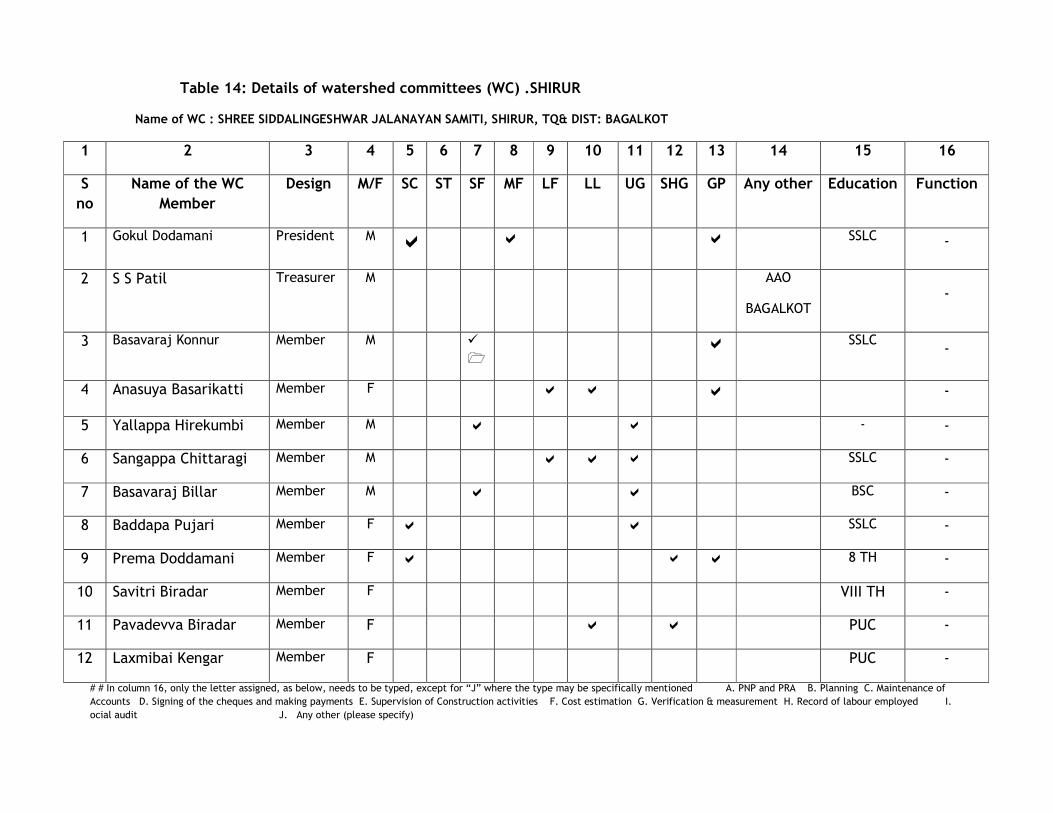
Table 14: Details of watershed committees (WC) .SHIRUR
Name of WC : SHREE SIDDALINGESHWAR JALANAYAN SAMITI, SHIRUR, TQ& DIST: BAGALKOT
1 2 3 4 5 6 7 8 9 10 11 12 13 14 15 16
S
no
Name of the WC
Member
Design M/F SC ST SF MF LF LL UG SHG GP Any other Education Function
1 Gokul Dodamani President M �
a
a SSLC -
2 S S Patil Treasurer M AAO
BAGALKOT
-
3 Basavaraj Konnur Member M �
�
a
SSLC -
4 Anasuya Basarikatti Member F a a a
-
5 Yallappa Hirekumbi Member M a a - -
6 Sangappa Chittaragi Member M a a a SSLC -
7 Basavaraj Billar Member M a a BSC -
8 Baddapa Pujari Member F a a SSLC -
9 Prema Doddamani Member F a a a 8 TH -
10 Savitri Biradar Member F VIII TH -
11 Pavadevva Biradar Member F a a PUC -
12 Laxmibai Kengar Member F PUC -
# # In column 16, only the letter assigned, as below, needs to be typed, except for “J” where the type may be specifically mentioned A. PNP and PRA B. Planning C. Maintenance of
Accounts D. Signing of the cheques and making payments E. Supervision of Construction activities F. Cost estimation G. Verification & measurement H. Record of labour employed I.
ocial audit J. Any other (please specify)
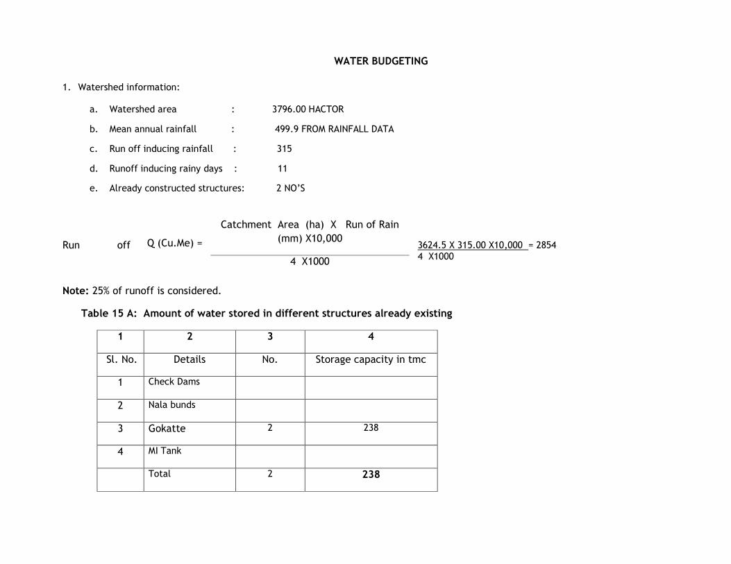
WATER BUDGETING
1. Watershed information:
a. Watershed area : 3796.00 HACTOR
b. Mean annual rainfall : 499.9 FROM RAINFALL DATA
c. Run off inducing rainfall : 315
d. Runoff inducing rainy days : 11
e. Already constructed structures: 2 NO’S
Run off 3624.5 X 315.00 X10,000 = 2854 4 X1000
Note: 25% of runoff is considered.
Table 15 A: Amount of water stored in different structures already existing
Q (Cu.Me) =
Catchment Area (ha) X Run of Rain
(mm) X10,000
4 X1000
1 2 3 4
Sl. No. Details No. Storage capacity in tmc
1 Check Dams
2 Nala bunds
3 Gokatte 2 238
4 MI Tank
Total 2 238
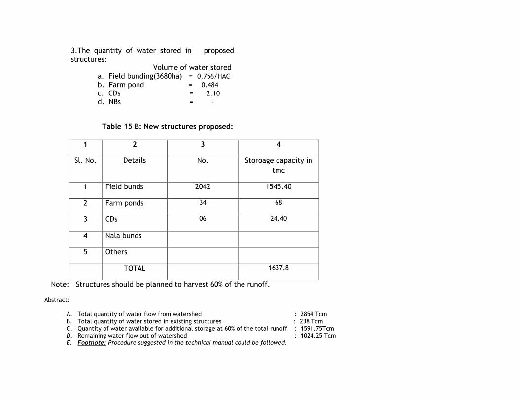
Table 15 B: New structures proposed:
1 2 3 4
Sl. No. Details No. Storoage capacity in
tmc
1 Field bunds 2042 1545.40
2 Farm ponds 34 68
3 CDs 06 24.40
4 Nala bunds
5 Others
TOTAL 1637.8
Note: Structures should be planned to harvest 60% of the runoff.
Abstract:
A. Total quantity of water flow from watershed : 2854 Tcm B. Total quantity of water stored in existing structures : 238 Tcm C. Quantity of water available for additional storage at 60% of the total runoff : 1591.75Tcm D. Remaining water flow out of watershed : 1024.25 Tcm E. Footnote: Procedure suggested in the technical manual could be followed.
3.The quantity of water stored in proposed structures:
Volume of water stored a. Field bunding(3680ha) = 0.756/HAC b. Farm pond = 0.484 c. CDs = 2.10 d. NBs = -
CHAPTER – 1 INTRODUCTION AND BACKGROUND

• Project Background, Project Location number of micro watershed with code
Integrated watershed management program is the only scheme implemented in Karanataka State under the common guidelines
2008 issued by govt of India with the super vision of central level nodal agency. In the state of Karanataka most of land is coming under
rainfed area and frequently affected by severe drought so here we find more scope to conserve rain water & make it in filter the soil. By
taking up some soil & water conservation activates by doing this with the help of above scheme we can conserve national resources and also
improve the productivity of the available land.
Under the scheme we are going to create the soil and water conservation structures, planting different drought resistant horticulture
speieces, forestry speiece & also to improve milk production by introducing some new perennial with help of local community.
So with the main aim of soil & water conservation & also to increase the income of local community with the integrated
approach of different sectors. The sate govt is going to implementing the scheme in the state of Karnataka.
IWPM-I Sub watershed located 18KM away from District HQ and 18KM from Taluka HQ it comes in the hobali bagalkot having
1GP’s, one watershed committees, 5 micro watersheds covering 1 number of villages Among total geographical area of 3624.50ha available
area for treatment is 3295ha, project located at Latitude 160 05
1 48
11 N 75
0 46
1 50
11 E Longitude. Major livelihood activities found are
vegetable marketing, petty shop business, tailoring, milk production units, nursery raising, Bangal shops, kirani shop etc. microenterprises &
traditional activities like dairy, animals rearing, birds rearing activities are also included.
SHIRUR sub watershed & micro code numbers & villages:
Name of the GP Name of SubW/S with code
No’s
Name of the MWS with code
No’s
Name of the villages
SHIRUR
SHIRUR
4D7C2I
4D7C2I1A
4D7C2I1B
4D7C2I1D
4D7C2I1E
4D7C2I1F
SHIRUR
• Need and Scope for Watershed Development
In the shirur watershed project Area generally land slope varies from 3-8% undulated land more proned for soil erosion, ground water
table is drastically gone down, migration in seeking of employment, small & maginal formers are more, less crop yield & NRM management &
sustainability problem is more that’s why there is great scope for watershed development in the selected watershed area. In view of the
steep land in the watershed, lack of conservation practices and erratic rainfall leads to the formation of rills & gullies in the cultivable area.
• Private Land
The reduction in the moisture holding capacity in the soil, erratic rainfall. Cropping pattern has been shifted from mixed cropping to
mono cropping, excess usages/application of fertilizer & pesticides, soil organic matter depleted. Many formers left cultivable lands as fallow
land because of low productivity of the lands
• Common Land
The degraded because of continuous mass grazing & people are also depend on common land for fuel wood so totally the common
land is left unmanaged. Hence it is required to manage it to conserve natural resources & other things.
• Drainage
Major drainage lands annual flow, periodicity is 4-6 months & few water harvesting structures are constructed along the
streams/nala’s & most of the structure are old and demolished few existing areas silted because of predominant area left untreated in the
catchment area. The banks of the nalas are slided & more bank damages in the drainage land because of the improper water management
. Water:
In the project area water used trends are changed people are facing severe problem even for drinking water almost
all open wells in the area are drayed up & water depth in the bore wells also gone down due to the effect of severe drought
occurred 5 years back.
• Erosion:
Due to less bio diversity, and also people depends on existing flora & fauna for fodder & fuel purposes. The existing
greenery is almost exhausted because of these the reason is more vulnerable erosion. So here the soils are required to conserve
and increase the biodiversity and greenery in watershed area.
• Watershed information
IWMP-Shirur watershed is geographical area 3624 ha and having area among this area available for treatment is 3295ha. It
covers 1gram panchayaths 1 sub watershed committees, 5micro watershed committees under the IWMP project. Project generally
having slope varies from 3-8 %, average rainfall 559 mm & uneven distribution of rainfall 20 to 46 heavy rainy days leads to soil
erosion. 0.30 to 0.7 organic carbon content is in the environment & average moisture percentage of 1.4 to 4.19. Regular crops
failures, poor vegetative cover, food, and fodder & fuel deficit. Project area included one gram panchayath’s. Development
works & measures taken so far are few infrastructure like school building, mettled roads, drinking water supply schemes are
present in the watershed, for agriculture family communities dependent on the RSK which is located 15KM away from the
watershed area.
Weightage for selection of watershed is
� Poverty index above 80%
� Equal wages are less
� More than 80% of small and marginal formers
� Less than 10% of area under assured irrigation
� Drinking water availability is less
� Migration
� Ground water table is decreased
� Soil and water conservation practices are less
� Lack of advanced agriculture technologies
� Heavy usage of fertilizers and chemical
Opportunities, constraints & limitation:
Watershed area consists good volume of waste and fallow land which can be converted into cultivable by implementing soil and
water conservation measures and migration can be mitigated by providing enough employment opportunity to the forming community. The
main trust area is to improve productivity of lands ends to improve the livelihood of the community.
1. Flora & Fauna : erosion in the bio-diversity; problems of feed and fodder for domestic animals; incidence of diseases; extent of
damage to local flora and fauna due
Because of severe erosion of the land productivity affected and bio mass coverage deteriorated as bio diversity exists in a scattered
manner with few shrubs and bushes resulting in definite. Fodder availability and frequent of draught and erratic rainfall made
community with respect to their livelihood more vulnerable
A) Technological gaps in the project area, reasons for the gaps and possibilities for views.
Due to the lack of awareness and updating on new technologies there is a gap exists in the area watershed has got potential zones for
adopting new technologies and techniques for the improvement of livelihood with respect to the farming community.
B) Brief narration of socio-economic problems Social class distribution based on the wealth ranking generated during PRA exercise;
Spatial location of below poverty line (BPL) families; states of landless people, their income levels, SHGs and other community based
organization (CBOs), NGOs working in the project area for the up fitment of landless classes.
Farmer:
1. Poor farmer unable to invest on land development individually
2. Different land classification, different farmer classes.
3. Unorganized
4. Dependent on external sources for all kind of inputs
SOIL:
1. Low soil fertility
2. Lack of humus content in the soil
3. Alkaline soil with PH 7.1 to 8.9
4. Av. Soil depth of 30 CM to 60 cm
5. Low productivity
6. Require immediate care with respect to conservation measure
ENVIRONMENT :
1. 525 mm average rainfall
2. Uneven distribution of rain fall
3. 20-46 rain days leading to soil erosion
4. 0.30-0.70 organic cargon content
5. Av moisture percentage of 1.40 to 4.19
6. Regular crop failures
7. Waste land existence
8. Lack of perennial streams / rivers
9. Poor vegetative cover
10. Food, fodder and fuel deficit
C) Development works and measures taken so far: Few infra structure like school building, metalled roads, and drinking water supply
schemes are present in the watershed, for agriculture inputs farming community is dependent on the RSK which is located 26 km away
from the watershed.
D) Opportunities, constraints and limitation: Watershed area consists good volume of waste and fallow land which can be converted into
cultivable by implementing soil and water conservation measures and migration can mitigated by providing enough employment
opportunity to the farming community. The main thrust area is to improve the productivity of lands and to improve the livelihood of
the community.
• Status of previous watershed programmes & other development project in the area No watershed program has been taken
in this area.
Note: Ensure that information for MIS table supplied by DoLR is reflected in relevant parts of DPR
CHAPTER - 2
GENERAL DESCRIPTION OF PROJECT AREA

ERROR: syntaxerror
OFFENDING COMMAND: --nostringval--
STACK:


![,Q 6LJKW - Woodley Equipment Company{ Wd l Wdd } u } ] P ~ í î { Wd ] P ~ í î 5HIHUHQFHù,QWHUYDOV v ] v W { Wd W í ð } î ì } v { Wdd W õ ð } í î ï } v & o ] v W { Wd](https://static.fdocuments.in/doc/165x107/5ffc423c4c10ee7f50357195/q-6ljkw-woodley-equipment-company-wd-l-wdd-u-p-wd-p-.jpg)