PROJECT MEMORANDUMfiles.lionsbay.ca/2014 Content/Infrastructure... · occurred at high tide, and...
48
(05670tmw/2005-08-04) PROJECT MEMORANDUM Client: VILLAGE OF LIONS BAY Date: August 4, 2005 DRAFT Project: TSUNAMI PROBABILITY AND MAGNITUDE STUDY Project No.: 05670 Subject: SUMMARY REPORT Page 1 of 11 1 Introduction 1.1 General Westmar Consultants Inc. (Westmar) has been commissioned by the Village of Lions Bay to perform a desktop study to determine the possible threat of a tsunami. The main body of the project memorandum provides an overview of the investigation, with details provided in Appendix A. The location of Lions Bay within Howe Sound is shown in Figures 3 and 4 in Appendix B and photographs of the shore are shown in Appendix C. Westmar has worked with Dr. Michael Isaacson, P.Eng., Dean of Applied Science at the University of British Columbia (UBC) and Dr. Michael Quick, P.Eng., Professor Emeritus, Civil Engineering Department at UBC, in performing this study, in addition to discussions with tsunami and geo-hazards experts. This study examines the sources and relative risks of tsunamis propagating to the Lions Bay site from the Pacific and from sources within the Strait of Georgia basin and Howe Sound area. 1.2 Definitions • Richter Scale: A logarithmic measure of earthquake magnitude, such that a magnitude change of 1.0 represents a 10 fold increase in amplitude (refer to Geological Survey of Canada (GSC)). Some of the larger magnitude earthquakes are described by the GSC as follows: • A Magnitude 7 earthquake is a “major” earthquake which causes serious damage up to about 100 km from the epicentre (e.g. a Magnitude 7.3 at Comox/Campbell River in 1946).
Transcript of PROJECT MEMORANDUMfiles.lionsbay.ca/2014 Content/Infrastructure... · occurred at high tide, and...

(05670tmw/2005-08-04)
PROJECT MEMORANDUM Client: VILLAGE OF LIONS BAY Date: August 4, 2005
DRAFT Project: TSUNAMI PROBABILITY AND MAGNITUDE STUDY Project No.: 05670 Subject: SUMMARY REPORT Page 1 of 11
1 Introduction 1.1 General Westmar Consultants Inc. (Westmar) has been commissioned by the Village of Lions Bay to perform a desktop study to determine the possible threat of a tsunami. The main body of the project memorandum provides an overview of the investigation, with details provided in Appendix A. The location of Lions Bay within Howe Sound is shown in Figures 3 and 4 in Appendix B and photographs of the shore are shown in Appendix C. Westmar has worked with Dr. Michael Isaacson, P.Eng., Dean of Applied Science at the University of British Columbia (UBC) and Dr. Michael Quick, P.Eng., Professor Emeritus, Civil Engineering Department at UBC, in performing this study, in addition to discussions with tsunami and geo-hazards experts. This study examines the sources and relative risks of tsunamis propagating to the Lions Bay site from the Pacific and from sources within the Strait of Georgia basin and Howe Sound area. 1.2 Definitions • Richter Scale: A logarithmic measure of earthquake magnitude, such
that a magnitude change of 1.0 represents a 10 fold increase in amplitude (refer to Geological Survey of Canada (GSC)). Some of the larger magnitude earthquakes are described by the GSC as follows:
• A Magnitude 7 earthquake is a “major”
earthquake which causes serious damage up to about 100 km from the epicentre (e.g. a Magnitude 7.3 at Comox/Campbell River in 1946).

PROJECT MEMORANDUM DRAFT TSUNAMI PROBABILITY AND MAGNITUDE STUDY Summary Report Page 2 of 11
(05670tmw/2005-08-04)
• A Magnitude 8 earthquake is a “great” earthquake that causes great destruction and loss of life over several hundred kilometres from the epicentre (e.g. 1949 in the Queen Charlotte Islands).
• A Magnitude 9 earthquake is a “rare great”
earthquake that causes major damage over a large region of over 1,000 km from the epicentre (e.g. Chile 1960, Alaska 1964 and the west coast of British Columbia, Washington and Oregon in 1700).
• Seiche: Long period oscillation of a water body that may be
induced by a tsunami or a series of events with the same natural period as the basin.
• Subduction: The vertical movement of tectonic plates relative to one
another. • Tsunami: A series of waves with periods in the order of several
minutes to more than an hour. • Tsunamigenic Earthquake: An earthquake that produces a tsunami, usually from
subduction events, but also from submarine slope failures or terrestrial landslides.
• Wave Height: The vertical distance from peak to trough of a wave. • Wave Period: The time between successive wave crests as measured
at a fixed point. • Wave Run-Up: The vertical distance above still water level that the wave
runs up the shore.

PROJECT MEMORANDUM DRAFT TSUNAMI PROBABILITY AND MAGNITUDE STUDY Summary Report Page 3 of 11
(05670tmw/2005-08-04)
2 Literature Search for Historical Records Hutchinson and McMillan (1997) provides anecdotal stories passed down through the ages by the native people, in particular for the Magnitude 9.0 earthquake on the west coast of Vancouver Island in 1700, and there are numerous accounts of devastation and loss of life from villages on the west coast of Vancouver Island, Washington and Oregon. There are also similar accounts from Cowichan and the Fraser Valley, and so Hutchinson cored sediments at the Fraser River delta and at Burns Bog in Delta to determine if there is evidence of large tsunamis at those locations (personal communication, July 2005). Hutchinson found evidence of small tsunami events at the Fraser River delta site, and no evidence of tsunamis at Burns Bog. Hutchinson recommends that lagoons on the north sides of Anvil and Gambier Islands be cored for evidence of tsunamis generated at the north end of Howe Sound, and on the south sides of Bowen and Gambier Islands and other suitable locations for evidence of tsunamis propagating from south to north within Howe Sound. The 1946 Vancouver Island earthquake in the Comox/Campbell River area (Magnitude 7.3) triggered more than 300 landslides over an area of 20,000 km2 (Mathews, 1979). According to Rogers and Hasegawa (1978), no major tsunami was created by this earthquake. However, water level disturbances were observed; one fatality was caused by overturning of a small boat. Murty and Crean (1986) made a numerical simulation of this tsunami, assuming that the earthquake caused a hypothetical 3 m vertical ground motion. The model domain consisted of the Strait of Georgia and several inlets, including Howe Sound. Their simulation showed some response in Howe Sound, and predicted a range of -0.9 m to 0.9 m at Squamish. The results of this model are not substantiated, as there were no reports of a tsunami at Squamish.
3 Review of Studies of Potential Tsunami Hazards A number of technical papers on tsunamis and geo-hazards were reviewed in undertaking this study, and a list is provided in Appendix A. Tsunami hazards for Lions Bay are those propagating to the site from the Pacific Ocean, generated by earthquakes in the Strait of Georgia basin, and from landslides or river delta failures within Howe Sound. Details of the research are provided in Appendix A, and are summarized on the following page.

PROJECT MEMORANDUM DRAFT TSUNAMI PROBABILITY AND MAGNITUDE STUDY Summary Report Page 4 of 11
(05670tmw/2005-08-04)
Tsunamis in the Pacific Ocean Tsunamis in the Pacific Ocean that impact the west coast of Vancouver Island are generated by subduction events off the coast of the Pacific Northwest, and as far away as Chile and Alaska. Several notable examples are as follows: • A maximum 5 m high tsunami that impacted Japan in about 1700 was estimated to have
been generated by a 9.0 magnitude earthquake off the west coast of Vancouver Island, and the tsunami destroyed villages on the British Columbia coast (Hutchinson and McMillan, 1997; Satake et al, 2003).
• A 5.2 m tsunami impacted Port Alberni in 1964 from an 8.75 magnitude earthquake in
1964, Alaska. • A 1.4 m tsunami impacted Tofino in 1960 from an 8.5 magnitude earthquake in Chile. A numerical model of a 7 m tsunami along the Pacific coastline, generated in the Cascadia subduction zone, shows that it would be reduced to 1 m by the time it reaches Lions Bay. A similar analysis by Clague et al (2003) demonstrated that a 15 m tsunami along the Pacific coastline would be reduced to less than 2 m by the time it reaches the area. Tsunamis Generated Within the Strait of Georgia Earthquakes within the Strait of Georgia have not been tsunamigenic, based on the lack of reports of tsunamis within the basin. Tsunamis generated in this area would likely be from terrestrial landslides or the slump of the Fraser River delta, caused by the shaking from an earthquake. A slump or sub-sea failure of the Fraser River delta has been proposed as a hazard that could produce a tsunami. However, quoted evidence of a slump may be the dredge disposal from the construction of the Roberts Bank Super-Port, and the numerical model of a tsunami generated from the failure of the delta is not supported by historical evidence of any such occurrence. The risk and magnitude of a tsunami generated by this mechanism to the communities along the shores of the Strait of Georgia basin and Lions Bay in particular could be quantified by analysing the failure of the delta in more detail. This would entail the following tasks: • Perform a geotechnical analysis of possible failures of the delta and the movement of
the delta by a geotechnical engineer. • Build a physical model to evaluate the tsunami that would be generated by the
movement of the delta.

PROJECT MEMORANDUM DRAFT TSUNAMI PROBABILITY AND MAGNITUDE STUDY Summary Report Page 5 of 11
(05670tmw/2005-08-04)
• Develop a numerical model to investigate the tsunami generated by the failure of the delta and the propagation of the tsunami around the Strait of Georgia basin and especially in Howe Sound.
The first two of these tasks are very expensive, and would require financial support from the Government and all interested parties. The third task can be carried out at more moderate cost using an available hydrodynamic model. The reduction in height of the tsunami as it propagates into the Georgia Strait and into Howe Sound can then be investigated by making reasonable assumptions of the initial tsunami magnitude. Terrestrial landslides could also generate tsunamis in the basin, and 300 landslides were generated by the Comox/Campbell River 7.3 magnitude earthquake of 1946. However, no significant tsunamis were reported, as noted in Section 2 of this report. Tsunamis Generated Within Howe Sound Tsunamis generated within Howe Sound would likely be from terrestrial landslides and submarine slope failures of the Squamish River delta. Debris flows and small rock slides along the Sea-to-Sky Highway are not likely to result in significant tsunamis. Information on geo-hazards in Howe Sound was obtained from technical papers and discussions with GSC personnel and other experts on the Sea-to-Sky corridor. The side slopes of Howe Sound are relatively sound and not subject to large failures, with two exceptions: • M. Gernais of the GSC in Vancouver noted that there are some deposits of weak
Garibaldi volcanic rock in the area south of Squamish (personal communication, July 2005). It is recommended that further research be performed to determine the location, mass and stability of Garibaldi volcanic rock in Howe Sound, as this is the same type of rock in the Cheekye Fan cliffs that are failing just north of Squamish.
• D. Smith of Thurber Engineering notes that there is a rock slide risk above Britannia
Beach, but that by the time the slide reaches Howe Sound, it will be similar to a debris flow (personal communication, July 2005), and will not produce a significant tsunami.
Submarine slope failures have occurred at Wooodfibre, Porteau Cove (D. Smith, personal communication, July 2005), Furry Creek (Westmar Hydrographic Survey, 2003) and Britannia Beach (Westmar work on the Water Treatment Outfall, 2005). There have been no recorded tsunamis from these events.

PROJECT MEMORANDUM DRAFT TSUNAMI PROBABILITY AND MAGNITUDE STUDY Summary Report Page 6 of 11
(05670tmw/2005-08-04)
It is possible that an underwater slope failure could occur at the Squamish River delta, similar to an underwater slope failure that occurred in Kitimat in 1975 (Murty, 1979). The tsunami wave produced at Kitimat was estimated to be 8 m, due to a submarine slip of about 10,000,000 cu. m of material. Assuming a similar occurrence at Squamish, and applying Green’s Law (see for example, Perroud, 1959; Ippen and Harleman, 1966), it is estimated that the tsunami would be about 2 m by the time it reached Lions Bay. This would only result in damage if the tsunami occurred at high tide, and then principally at the marina as shown in Photograph No. 1. The tsunami would run up about 2 m above water level at this location, and the marina appears to be less than 2 m above higher high water.
4 Geographical Considerations Bathymetry and Inlet Geometry Effects The bathymetry in the vicinity of Lions Bay, which has relatively deep water close to the shore, is not conducive for magnifying a tsunami wave, whereas at Squamish, there is a shoaling potential due to the shallow water, similar to the situation at Port Alberni, and also the wave would be reflected at the head of the inlet causing a local doubling of wave height, as was observed in Alberni Inlet. Therefore, as no tsunamis have been observed at Squamish, there is less likelihood of significant tsunamis at Lions Bay. Sheltering by Vancouver Island A numerical model of a tsunami propagating to the site from the Pacific Ocean was developed by the Department of Fisheries and Oceans (DFO) in Patricia Bay, BC, and is available on their web site (http://www-sci.pac.dfo-mpo.gc.ca/osap/projects/tsunami/ tsunamimodel_e.htm). A series of images from a simulation are provided in Figure 6 in Appendix B, which shows that a tsunami with a wave height of 7 m tsunami along the Pacific coastline, generated in the Cascadia subduction zone, is reduced to a height of 1 m at Lions Bay.

PROJECT MEMORANDUM DRAFT TSUNAMI PROBABILITY AND MAGNITUDE STUDY Summary Report Page 7 of 11
(05670tmw/2005-08-04)
5 Discussion of Risk The risk of a damaging tsunami impacting Lions Bay is low, although it cannot be quantified precisely at this time. This low risk is from approximately a 2 m tsunami with a return period in the range of about 100 years to 1,000 years, based on the following: • Large tsunamigenic subduction events occur about once in every 500 years (Clague,
2001) on the west coast of Vancouver Island, and are greatly reduced in height, from 15 m to 2 m, by the time they propagate to Lions Bay.
• Large tsunamis in the Strait of Georgia basin and Howe Sound areas have not been
recorded. Hutchinson and McMillan (1997) provides anecdotal reports of tsunami events at Cowichan and the Fraser Valley, but these reports were not substantiated by Hutchinson when he drilled and analyzed cores of the Fraser River delta and Burns Bog in July 2005.
• There is no evidence that large earthquakes within the Strait of Georgia have caused
large tsunamis. Therefore, the risk of an earthquake in the Strait of Georgia basin resulting in a large tsunami is considered to be low as there is no historic evidence that they have caused large tsunamis. If considered necessary, the risk and effect of a tsunami resulting from the failure of the Fraser River delta may be examined in more detail, as discussed in Section 3 above.
• The deep water adjacent to Lions Bay will not cause an amplification of a tsunami at that
location, unlike the amplification that occurs at the head of inlets such as at Port Alberni. • The risk from large terrestrial landslides in Howe Sound is probably low, but more work
is required to quantify the risk, and a study is recommended to locate and determine the mass and stability of Garibaldi volcanic rock in Howe Sound.
• The risk from tsunamis produced by underwater slope failures of deltas in Howe Sound
is low, as past failures of submarine slopes at Woodfibre, Porteau Cove, Britannia Beach and Furry Creek have not resulted in noticeable tsunamis. It is estimated that a submarine slope failure of the Squamish River delta, similar to the Kitimat event of 1975, would produce about a 2 m tsunami at Lions Bay, which could result in damage, principally to the marina, if the tsunami coincided with a higher high water, large tide condition. It is recommended that a geotechnical analysis of the stability of the Squamish River delta, and a numerical model of a tsunami resulting from a submarine slump of the delta as it propagates from north to south in Howe Sound, be performed to better define the risk and effects of this hazard.

PROJECT MEMORANDUM DRAFT TSUNAMI PROBABILITY AND MAGNITUDE STUDY Summary Report Page 8 of 11
(05670tmw/2005-08-04)
6 Summary and Recommendations 6.1 Summary This study provides a desktop study of the possible risks and magnitudes of tsunamis for the Village of Lions Bay. Experts on tsunamis and geo-hazards were contacted and technical papers were reviewed in performing this study. The following conclusions were developed as a result of this study: • The risk of a significant tsunami impacting Lions Bay is qualitatively low, compared with
sites on the west coast of Vancouver Island, but the risk cannot be quantified precisely at this time. In the present context, low risk is defined as approximately a 2 m tsunami at Lions Bay with a return period in the range of about 100 years to 1,000 years.
• Tsunamis propagating to the site from the Pacific Ocean due to a subduction
mechanism are considered a low risk because of the large reduction in wave height as the tsunami propagates into the Strait of Georgia and Howe Sound, as determined from a numerical model developed at the Institute of Ocean Sciences, Patricia Bay, BC.
• There are no records of any significant tsunamis in the Strait of Georgia basin, and
recent coring in July 2005 at the Fraser River delta has found evidence of, at most, a small tsunami event that still needs to be verified, and coring of Burns Bog did not indicate any evidence of a tsunami impacting that area (Hutchinson, personal communication, July 2005).
• There are, at present, no records of any tsunamis in Howe Sound. • Risks from extreme events have been identified as follows:
• A large earthquake centred within the Strait of Georgia basin, which could trigger a slump of the Fraser River delta or a landslide along the shores of the basin. Rabinovich et al (2003) uses a numerical model to predict a large tsunami generated from a slump of the Fraser River delta.
• A large earthquake centred in Howe Sound, which could trigger a terrestrial
landslide and cause a tsunami. The rock walls along Howe Sound are relatively solid except, however, for rare occurrences of Garibaldi volcanic rock, an area which needs further study (Gernais, personal communication, July 2005).
• The risks from the extreme events are not known, but are judged to be low, due to the
lack of observed tsunamis of any significance in the area.

PROJECT MEMORANDUM DRAFT TSUNAMI PROBABILITY AND MAGNITUDE STUDY Summary Report Page 9 of 11
(05670tmw/2005-08-04)
• The conclusion of Clague et al (2003) is that a tsunami in Howe Sound would be less than 2 m in height in the case of a large tsunami in the Pacific Ocean. This size of tsunami would have minimal effect on property at Lions Bay for the following reasons:
• The maximum run-up would be in the order of 2 m above sea level.
• The tide range is about 5 m, and the waterfront homes are generally built in the
order of 2 m to 3 m above higher high water, large tide.
• Only at the highest tide would there be any possibility of minor inundation of the waterfront properties, principally the marina which is lower in elevation, and the combined probability of a tsunami with higher high water is small.
• In the event of a large submarine landslide at the Squamish River delta that is similar to
the 1975 event in Kitimat, it is expected that any tsunami occurring at Lions Bay is unlikely to exceed 2 m.
6.2 Recommendations If deemed necessary, the following studies are recommended to assist in quantifying the risk: • Study the risk and magnitude of a terrestrial landslide and the resulting tsunami,
particularly from any Garibaldi volcanic rock formations on the sides of Howe Sound. • Further study of the risk and magnitude of a tsunami that would be generated by the
submarine slumping of the Fraser River delta. • Model the tsunami that could be generated by submarine slope failure of the Fraser
River delta, as it propagates from the Strait of Georgia into Howe Sound, utilizing a hydrodynamic model such as MIKE21 HD which Westmar has utilized in studying tsunamis at Port Alberni.
• Core lagoons on the north sides of Anvil and Gambier Islands and other locations to
obtain indications of tsunamis originating from the north end of Howe Sound. • Core lagoons on the south sides of Bowen and Gambier Islands and in the Squamish
area and other locations to obtain indications of tsunamis originating from the south end of Howe Sound.

PROJECT MEMORANDUM DRAFT TSUNAMI PROBABILITY AND MAGNITUDE STUDY Summary Report Page 10 of 11
(05670tmw/2005-08-04)
• Model a tsunami propagating in Howe Sound, from both the southern entrance to Howe Sound (for the case of a tsunami generated within the Strait of Georgia basin) and from the northern end of Howe Sound (for the case of a tsunami generated from either a terrestrial landslide or a submarine slope failure of the Squamish River delta).
• Based on the above studies, perform an evaluation of the risks to determine if a tsunami
warning system would be appropriate for the site, similar to the one currently operating at Port Alberni.
Many of these tasks would involve considerable expense, but they would be relevant to many agencies and entities occupying and operating within the Georgia Basin. Therefore, a centrally coordinated study sponsored by all the interested parties might be the way to proceed.
7 References Clague, J.J., 2001. The earthquake threat in southwestern British Columbia. Office of Critical Infrastructure Protection and Emergency Preparedness. Government of Canada. Clague, J.J., Munro, A., and Murty, T.S., 2003. Tsunami hazard and risk in Canada. Natural Hazards 28 (2-3), 407-434. Hutchinson, I. and McMillan, A.D., 1997. Archeological evidence for village abandonment associated with Late Holocene Earthquakes at the Northern Cascadia Subduction Zone. Quaternary Research, 48, 79-87. Ippen, A.T. and Harleman, D.R.F., 1966. Tidal dynamics in estuaries. In: A.T. Ippen (Ed.) Estuary and Coastline Hydrodynamics. McGraw-Hill Book Company Inc., New York. Mathews, W.H., 1979. Landslides of central Vancouver Island and the 1946 earthquake. Seismological Society of America Bulletin 69, 445-450. Murty, T.S., 1979. Submarine slide-generated water waves in Kitimat Inlet, British Columbia. Journal of Geophysical Research, 84 (C12), 7777-7779. Murty, T.S. and Crean, P.B., 1986. Numerical simulation of the tsunami of June 23, 1946 in British Columbia, Canada. Science of Tsunami Hazards, 4, 15-24. Perroud, P., 1959. The propagation of tidal waves into channels of gradually varying cross-sections. Technical Memorandum No. 112. Beach Erosion Board, Washington, DC.

PROJECT MEMORANDUM DRAFT TSUNAMI PROBABILITY AND MAGNITUDE STUDY Summary Report Page 11 of 11
(05670tmw/2005-08-04)
Rogers, G.C. and Hasegawa, H.S., 1978. A second look at the British Columbia earthquake of June 23, 1946. Bulletin of the Seismological Society of America, 68(3), 653-675. Rabinovich, A.B., Thomson, R.E., Bornhold, B.D., Fine, I.V. and Kulikov, E.A., 2003. Numerical modelling of Tsunamis Generated by Hypothetical Landslides in the Strait of Georgia, British Columbia. Pure and Applied Geophysics, 160, 1273-1313. Satake, K., Wang, K. and Atwater, B.F., 2003. Fault slip and seismic moment of the 1700 Cascadia earthquake inferred from Japanese tsunami descriptions. Journal of Geophysical Research, 108 (B11), 7-1 - 7-17.
End of Project Memorandum Prepared by: Dilip Barua, Ph.D., P.Eng. Coastal Engineer Approved by: __________________________________
Norman Allyn, P.Eng. Manager Coastal Engineering NFA/tmw Encl. 3

PROJECT MEMORANDUM DRAFT TSUNAMI PROBABILITY AND MAGNITUDE STUDY Summary Report
APPENDIX A
Details of Investigation on Tsunamis at Lions Bay

PROJECT MEMORANDUM APPENDIX A TSUNAMI PROBABILITY AND MAGNITUDE STUDY DRAFT Summary Report Page 1 of 13
(05670tmw/2005-08-04)
DETAILS OF INVESTIGATION ON TSUNAMIS AT LIONS BAY 1 Introduction 1.1 General Tsunamis are series of waves with periods in the order of several minutes to more than an hour that are mostly generated by underwater ground motion. The primary cause of a tsunami is the release of energy associated with crustal deformation resulting from an earthquake (Murck et al, 1996). An earthquake that produces a tsunami is known as a tsunamigenic earthquake. The magnitude of an earthquake does not dictate the production or the size of a tsunami. It is rather decided by the type of rupture motion. For example, the horizontal strike-slip earthquake does not produce a tsunami. By contrast, when the sea floor undergoes vertical deformation, it pushes huge volumes of displaced water outward from the zone of deformation causing a tsunami. Most large tsunamis in the Pacific Ocean have been triggered by earthquakes occurring within the subduction zones (Anderson and Gow, 2004). This indicates that there exists a great potential for a tsunami to occur, if there is an earthquake in the Cascadian subduction zone (Figure 1 in Appendix B). The Intergovernmental Oceanographic Commission (2001) suggests that an earthquake has to have a magnitude of 7.5 or greater to produce a tsunami capable of causing damages at a distance from the source. South-Western British Columbia, located within 200 km to 350 km epicentral distance of the Cascadian subduction zone, experiences more than 200 earthquakes each year making it one of the Canada's most seismically active regions (Rogers, 1998). Nine earthquakes of moderate magnitude (Magnitude 6 to 7) have occurred within 250 km of Vancouver and Victoria during the last 130 years (Rogers, 1998). Clague (2001) gives an idea of recurrence intervals of earthquakes in British Columbia and North-Western Washington. According to him, the average recurrence of earthquakes of Magnitude 8 to 9, 7 to 7.6, 6 and 5 are 500, 30 to 40, 20 and 5 years, respectively. According to the 1990 National Building Code (NBC) seismic zones classification for British Columbia, the coastal area belongs to NBC Seismic Zones 4 to 6, with ground velocities ranging from 0.20 to 0.40 of gravitational acceleration. 1.2 Howe Sound and the Village of Lions Bay Howe Sound is a funnel shaped fjord that extends from Horseshoe Bay in the south to Squamish delta in the north (Figures 2 and 3 in Appendix B). The village of Lions Bay is located on the east shore mountain slope near Alberta Creek, Harvey Creek and Rundle Creek at about 9 km north of Horseshoe Bay (Figure 3 in Appendix B). The village extends across the Sea-to-Sky Highway and BC Rail tracks from 100's of metres up in the mountain slope to lower elevations along Howe Sound. The gradient of the mountain slope above the fans varies from 23 degrees to 57 degrees, while the gradients of the fans are about 14 degrees (Evans and Savigny, 1994).

PROJECT MEMORANDUM APPENDIX A TSUNAMI PROBABILITY AND MAGNITUDE STUDY DRAFT Summary Report Page 2 of 13
(05670tmw/2005-08-04)
Rock falls, rock slides and debris flow are a hazard in the Howe Sound - Lillooet corridor (Lister et al, 1984; Evans and Savigny, 1994; Hungr et al, 1999). The mountains are characterized by steep glacial-valley slopes (Figure 4 in Appendix B). The common stream-bed slope is within a 20 degree to 40 degree range, sometimes as high as 57 degrees (Lister et al, 1984). Hungr et al (1999) reported some 443 known records of rock falls and rock slides in the corridor. Evans and Savingny (1994) reported that there have been 48 deaths and millions of dollars of damage to private and public properties since 1921. Although these were hazardous to highway traffic and people, none of them is reported to have caused a wave or tsunami in Howe Sound. A field visit was conducted on July 25, 2005 to the village, and several photographs are provided in Appendix C. Photograph Nos. 1 and 2 in Appendix C show the village marina and some waterfront homes. Photograph No. 1 in Appendix C indicates that the marina area is only about 1 m above the high watermark and Photograph No. 2 in Appendix C gives the impression that the lowest elevation of the village park and households, are at least about 2 m to 3 m above the high water marks. 1.3 Objective This study is commissioned by the Municipality of the Village of Lions Bay. The objective of this work is to perform a desktop study of the possible threats of tsunamis for the Village of Lions Bay. 2 Tsunami Sources Figure 5 in Appendix B shows a schematic presentation of all the possible sources of tsunamis for the Village of Lions Bay. The Pacific sources include the tsunamis generated in the Pacific Rim countries and tsunamis generated in the Cascadia subduction zone (Figure 1 in Appendix B). The tsunamis from the Pacific go through considerable transformation while propagating through the Juan de Fuca Strait and the Strait of Georgia into the area of interest in Howe Sound. The local sources include those tsunamis that are generated in the Strait of Georgia and Howe Sound. In these water bodies, the three possible sources are tsunamigenic earthquakes, submarine slope failures and terrestrial landslides. 2.1 The Pacific Sources 2.1.1 Tsunami from the Pacific Ocean There are several sources of tsunamis in the Pacific Ocean. Recent large tsunami events include the 1960 Chile earthquake and the 1964 Alaska earthquake. Since the Second World War, there have been five notable cases of earthquakes in the pacific, all of which have caused tsunami along the British Columbia coast (Murty and Henry, 1971). These are: • The April 1, 1946 Aleutian earthquake with a Magnitude 7.25 that caused a 0.58 m tsunami
at Tofino (see Figure 2 in Appendix B for location).

PROJECT MEMORANDUM APPENDIX A TSUNAMI PROBABILITY AND MAGNITUDE STUDY DRAFT Summary Report Page 3 of 13
(05670tmw/2005-08-04)
• The November 4, 1952 Kamchatka earthquake with a Magnitude 8.5 that caused a 0.61 m tsunami at Tofino (see Figure 2 in Appendix B for location). Victoria harbour noticed minor waves.
• The March 9, 1957 Aleutian earthquake with a Magnitude 8.5. There is no documented
information on tsunami heights caused by this earthquake. • The May 22, 1960 Chile earthquake with a Magnitude 8.5 that caused a 1.4 m tsunami at
Tofino (see Figure 2 in Appendix B for location). • The March 28, 1964 Alaska earthquake with a Magnitude 8.75 that caused a large tsunami
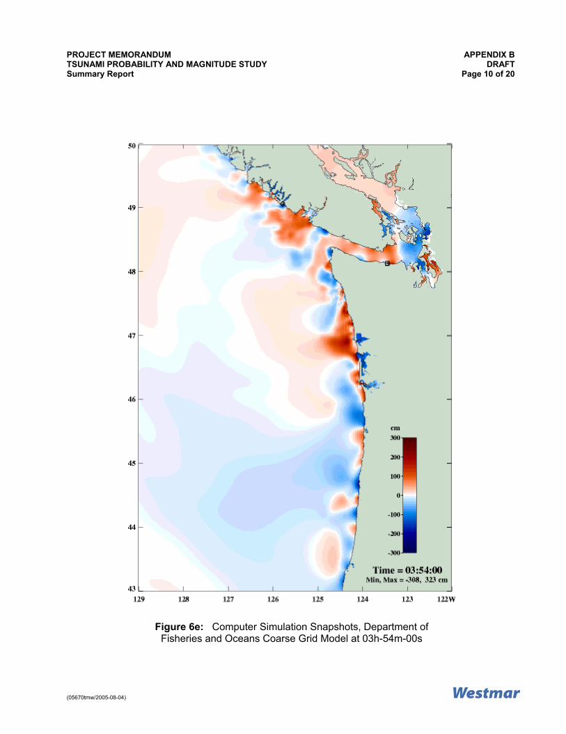
of 5.2 m at Port Alberni (see Figure 2 in Appendix B for location). These events have not been reported to have caused any significant tsunamis or damage in the interior areas adjacent to the Strait of Georgia shoreline. Even along the Vancouver Island west coast, only two out of 43 tsunamis recorded at the Tofino tide gauge produced waves more than 1 m high (Clague, 2001). 2.1.2 Tsunami Generated in the Cascadia Subduction Zone In 1700, a tsunami was caused by an earthquake on the Cascadia subduction zone, off the coast of British Columbia (Figure 1 in Appendix B). This tsunami is reported to have caused widespread damage in other Pacific Rim countries, as far as Japan (Clague, 2001). There was a significant tsunami at the British Columbia coast, according to anecdotal stories passed down through the ages by the native people (Hutchinson and McMillan, 1997). Since then, there has not been any large tsunamis generated in the Cascadia subduction zone. Analysis indicates that major Cascadian earthquakes accompanied by destructive tsunamis have an average recurrence interval of 500 years (Clague and Bobrowsky, 1999; Clague et al, 2003). The Department of Fisheries and Oceans has made a numerical simulation of tsunami generation in the Cascadia and its propagation. Figure 6 (6a to 6l) in Appendix B shows 10 snapshots of a 12-hour tsunami coarse-grid simulation caused by a hypothetical Cascadia subduction earthquake. They are derived from Department of Fisheries and Oceans website. The link is shown below. The maximum tsunami height of about 7 m in the Cascadia reduces in height to about 1 m and less in most regions of the Strait of Georgia and Howe Sound. The results of this model run are not substantiated by any historical data. • Relevant URLs or web links are as follows:
• Department of Fisheries and Oceans Tsunami website:
• http://www-sci.pac.dfo-mpo.gc.ca/osap/projects/tsunami/tsunamimodel_e.htm • http://www.pac.dfo-mpo.gc.ca/sci/osap/projects/tsunami/default_e.htm • http://www.pac.dfo-mpo.gc.ca/sci/osap/projects/tsunami/tsunamilinks_e.htm

PROJECT MEMORANDUM APPENDIX A TSUNAMI PROBABILITY AND MAGNITUDE STUDY DRAFT Summary Report Page 4 of 13
(05670tmw/2005-08-04)
• Pacific Geoscience Centre, Natural Resources Canada:
• http://www.pgc.nrcan.gc.ca/ • http://www.pgc.nrcan.gc.ca/seismo • http://www.pgc.nrcan.gc.ca/geodyn/eqpro.htm
• Resource Library:
• http://library.lanl.gov/tsunami/sth.htm ------ Search the page for "British
Columbia" Some order-of-magnitude estimates of tsunami parameters caused by a tsunamigenic earthquake (USACE, 1989) are provided in Table 1. These are based on some simple empirical relations that relate tsunami height and period to tsunami magnitude. The water depth at the location of generation is important only for shoaling of tsunamis at the point of interest. These numbers are by no means an indication of the probable occurrence of tsunami in the region.
TABLE 1: Some Approximate Estimates of Tsunami Generated by a Tsunamigenic Earthquake
Earthquake Magnitude on the Richter Scale
Height of Tsunami Generated at the Source Depth of 200 m (m)
Period of the Generated Tsunami (minutes)
5.5 0.1 1.3
6.0 0.3 2.8
6.5 0.6 5.7
7.0 1.5 12.0
7.5 3.6 24.0
8.0 8.5 49.0
8.5 21.0 101.0 2.1.3 Propagation of Distant Tsunamis into the Region There are no reports to suggest that the tsunamis listed in Section 2.1.1 and recorded at the Vancouver Island west coast, have propagated through the Juan de Fuca Strait and the Strait of Georgia, and there are no reports of any damage in the lower mainland area. Numerical simulation through a 2 km coarse grid model of the Juan de Fuca Strait and the Strait of Georgia by Ng et al (1991) suggests reduction in height of the incident tsunami while it propagates into the Strait of Georgia. The tsunami heights predicted by this model are not substantiated by any field observations. The height reductions can also be seen in the simulation results presented in Figure 6 in Appendix B. Height reduction is understandable considering the large areas of the Strait of Georgia and Puget Sound relative to the narrow width of the Juan de Fuca Strait. In addition, the Strait of Georgia is quite deep, and therefore, does not cause any significant shoaling and amplification of the incident wave. However, it is possible that so far the incident tsunami periods were not close to the natural period of the basin consisting of the Strait of Georgia and Puget Sound to cause any amplification. Clague (2001) states that "The coastline of the Strait of Georgia is not threatened by far-travelled Pacific tsunamis."

PROJECT MEMORANDUM APPENDIX A TSUNAMI PROBABILITY AND MAGNITUDE STUDY DRAFT Summary Report Page 5 of 13
(05670tmw/2005-08-04)
2.2 The Local Sources 2.2.1 Tsunamigenic Earthquakes The 1946 Vancouver Island earthquake (Magnitude 7.3) triggered more than 300 landslides over an area of 20,000 km2 (Mathews, 1979). According to Rogers and Hasegawa (1978), no major tsunami was created by this earthquake. However, water level disturbances were observed; one fatality was caused by overturning of a small boat. Murty and Crean (1986) made a numerical simulation of this tsunami, assuming that the earthquake caused a hypothetical 3 m vertical ground motion. The model domain consisted of the Strait of Georgia and several inlets including the Howe Sound. Their simulation showed some response in Howe Sound, and predicted a range of -0.9 m to 0.9 m at Squamish. The results of this model are not substantiated. It is important to realize that the local earthquakes in the Strait of Georgia or Howe Sound are not tsunamigenic, because no vertical ground motion is involved. These earthquakes can best generate seiches due to ground motion. A seiche is the sloshing of a closed body of water from, for example, earthquake shaking. Seiches caused by earthquakes are termed as seismic seiches. However, earthquakes in this region can trigger landslides that can generate local tsunamis, like the one in 1946. This aspect is discussed further in later sections. Geological Survey of Canada has listed 23 earthquakes with magnitudes greater than 4.8 during the last five years in South-Western British Columbia. There are no reports of tsunamis created by these earthquakes. Figure 7 in Appendix B shows epicentres of all past Magnitude 3 and higher earthquakes in South-Western British Columbia. In total, 1,892 earthquakes (magnitude greater than or equal to 3) occurred, out of which historical records show that only the 1700 earthquake of Magnitude 9 has caused tsunami. Figure 8 in Appendix B shows frequency distributions of these earthquakes. Magnitude 7 to 7.4 earthquakes are exceeded by 99.89% of events. In the Howe Sound area, historically earthquakes have been minor. Within the 30 km epicentral distance of Squamish, 67 minor earthquakes with magnitudes less than 2.6 occurred during the last five years. Figure 9 in Appendix B shows the frequency distributions of these earthquakes. These earthquakes are too low to cause any seiches or trigger a submarine slope failure (Keeper, 1984). 2.2.2 Submarine Slope Failure Although less frequent, local tsunamis are also generated by displacements of water resulting from rock falls, icefalls and sudden submarine landslides and slumps. The latter is caused by instability and sudden failure of submarine slopes, sometimes triggered by ground motions of a strong earthquake. Some worldwide examples include: • In Southern France in the 1980's, earth moving and construction work for an airport runway
at the coast triggered an underwater landslide that caused a destructive tsunami in the harbour of Thebes.
• A tsunami in 1998 killed thousands of people and destroyed coastal villages along the
northern coast of Papua-New Guinea. This tsunami was generated by a large underwater slump of sediments triggered by an earthquake.

PROJECT MEMORANDUM APPENDIX A TSUNAMI PROBABILITY AND MAGNITUDE STUDY DRAFT Summary Report Page 6 of 13
(05670tmw/2005-08-04)
• The largest recorded landslide tsunami was caused by a rock fall in Lituya Bay, Alaska on July 9, 1958. Triggered by an earthquake along the Fairweather fault, a rock fall of approximately 40 million cubic metres occurred at the head of the bay.
• A tsunami in 1929 in Newfoundland was caused by an earthquake triggered landslide on the
edge of the Grand Banks. In British Columbia, a large tsunami was created in Kitimat Inlet due to a submarine landslide on April 27, 1975. The event involved sliding of some 107 m3 of materials with an estimated tsunami height of 8.2 m (4.6 m crest and 3.6 m trough) (Murty, 1979). A thorough investigation reveals that such events had repeatedly taken place in this fjord in 1952 to 1968, 1971 and 1974 (Murty, 1979; Prior et al, 1981a, b; Johns et al, 1986). An estimate of possible tsunami heights can be made using Green's Law (see for example, Perroud, 1959 and Open and Harleman, 1966) for a simplistic assumption of constant depth but varying width. An 8 m tsunami generated by a submarine slope failure at Squamish delta (similar to the one at Kitimat in 1975, a conservative assumption) in a width of about 400 m would reduce in height to about 2 m near Lions Bay for an approximate channel width of about 6,500 m, utilizing the relationship that the height is inversely proportional to the square root of the channel width. The 1946 earthquake triggered underwater slope failure, and debris flows caused damages of underwater telephone cables (Rogers, 1980) in the Malaspina Strait. In the Fraser River delta, five known underwater slides occurred between 1970 and 1985 (McKenna et al, 1992; Chillargie et al, 1997a, b). Geotechnical and geomorphologic investigations show that submarine landslides in the Strait of Georgia are mostly caused by liquefaction failures (Christian et al, 1997a, b; Chillarige et al, 1997a, b). There have been several cases of submarine slope failures in Howe Sound (Evans and Savigny, 1994). The 1955 Woodfibre Creek delta failure caused widespread damages including the closure of the pulp mill (Bornhold, 1983). Terzaghi (1956) studied the failure mechanism of this delta and concluded that the failure was triggered by excess pore pressure developed during an extreme low water. A side-scan sonar survey of the site by Prior et al (1981a, b), found the evidence of widespread mass movement on the delta. Submarine slope failures also occurred on the delta of Britannia Creek at Britannia Beach (Moore, 1983; Prior and Bornhold, 1986). In June 1957, a section of the British Columbia Railway was destroyed by a submarine slump on the delta (Moore, 1983). Squamish delta is another potential area vulnerable to submarine failure. Hickin (1989) reported that Squamish River delivers some 1.29 million cubic metres of sediments per year with consequent delta progradation by some 3.86 m/year. Side-scan sonar investigations show instability of the Squamish delta (Prior and Bornhold, 1984). Submarine slope failures are characterized by two types of motions. They are planar landslide failure and the rotational slump (Terzaghi, 1956; Watts and Borrero, 2001). Terzaghi (1956) made a detailed discussion on the mechanics of submarine slope failure.

PROJECT MEMORANDUM APPENDIX A TSUNAMI PROBABILITY AND MAGNITUDE STUDY DRAFT Summary Report Page 7 of 13
(05670tmw/2005-08-04)
Submarine landslide generated tsunami models vary widely in their assumptions: • An energy dissipation model is proposed by Murty (1979) using energy and solitary wave
generation relations proposed by Striem and Miloh (1975) and Wiegel (1964). The relation has been used by Kulikov et al (1996), to estimate landslide generated wave height at Skagway Harbor, Alaska.
• The Pelinovsky and Pelinvosky (1996) model, assumes a rigid body slide motion of the
failure slab. • The Jiang and LeBlond (1992) model, assumes a viscous flow of the slide material. The
wave is generated through a continuity equation. • Watts (1998) proposed a relation based on rigid slab slide motion dynamics. • Yang and Isaacson (2004) proposed a relation for wave-paddle, or a horizontally moving
slide generated waves. Irrotational flow assumption limits the applicability of this model to short wave generation.
• There are also submarine landslide induced short wave generation models proposed by
Grilli et al (2000). Rabinovich et al (2003) discussed and made numerical simulations of underwater landslide generated tsunamis for two potential areas in the Strait of Georgia: • Malaspina Strait • Roberts Bank on the southern Fraser River delta. The hypothetical numerical simulation by Rabinovich et al (2003), using Jiang and LeBlond (1992) model, shows very large tsunamis. A 6 m to 8 m high tsunami was caused on Texada Island by a slide of 1,250,000 m3 in Malaspina Strait. Roberts Bank slides of 0.75 km3 and 0.23 km3 of slides created up to 18 m high tsunamis. These results, not verified by any field observation, should be treated as indicative and preliminary. The model does not show propagation of the generated tsunami beyond the limit of a small area close to the slide. It is recommended that this model be linked to a hydrodynamic model to simulate propagation of the tsunami in the Strait of Georgia basin and the Howe Sound areas. 2.2.3 Terrestrial Landslide According to Lister et al (1984) and Evans and Savigny (1994), the Sea-to-Sky Highway and the railway in the vicinity of the Village of Lions Bay are vulnerable to debris torrents and rock falls. Two known debris torrents occurred at Alberta Creek (Lister et al, 1984). The one on February 11, 1983, transported some 10,000 m3 to 15,000 m3 of debris across the highway causing widespread damages to properties (Lister et al, 1984). Such debris flows, even in large volumes, would certainly disperse and lose most of its momentum while flowing from a mountain slope of 27 degrees to the fan slope of 14 degrees. Therefore, apart from some minor disturbances, no tsunami is expected.

PROJECT MEMORANDUM APPENDIX A TSUNAMI PROBABILITY AND MAGNITUDE STUDY DRAFT Summary Report Page 8 of 13
(05670tmw/2005-08-04)
3 Magnitude and Probability Clague et al (2003) classified the Strait of Georgia and several of its inlets including Howe Sound, as a low tsunami hazard zone with a run-up height less than 2 m. Is there a real threat to tsunami hazards for the Village of Lions Bay? Given the uncertainty and quality of available data of tsunamigenic sources, there is no definite answer to the above question. The numerical model predictions, most of which are not verified, show very high tsunami heights, while in reality the tsunamis went unnoticed. Therefore, model predictions are not usable at this stage of risk assessment. Only a relative risk rating is possible. Table 2 shows some reasonable estimates of tsunami magnitude and probability in relative rating. The following discussions explain the reasons for all the possible sources identified earlier: • All studies related to the distant and locally generated tsunamis at the Cascadia subduction
zone in the Pacific, and their propagation through the Strait of Georgia, suggest reduced heights of the incident waves. Waves entering through the relatively narrow Juan de Fuca Strait must lose most of their energy in the wider basin of the Strait of Georgia and Puget Sound (Rabinovich et al, 2003; and the Department of Fisheries and Oceans tsunami animation: http://www-sci.pac.dfo-mpo.gc.ca/osap/projects/tsunami/tsunamimodel_e.htm). By the time the tsunami reach Howe Sound, it may reduce further near Lions Bay, but amplify somewhat at the head of the Sound. In addition to an insignificant magnitude from this source, the tsunami will give enough lead time (more than four hours!) for warning and emergency preparedness. Tsunami from this source can be rated as low risk.
• The earthquakes with epicentres in local water bodies of the Strait of Georgia and Howe
Sound are usually not tsunamigenic. The reason is that there is no vertical slip or subduction of the plates is involved. The earthquake shaking may generate some seiches. However, a seiche of considerable height in the large Strait of Georgia and Howe Sound system is unlikely from an earthquake shaking. Therefore, tsunamis for this source can be rated as low risk.
• All evidences suggest that submarine slope failures have occurred in the Strait of Georgia,
Howe Sound and other water bodies of British Columbia. Most of these were triggered by earthquakes, some by construction activities, while others by excess pore water pressure. In Howe Sound itself, but not near the Lions Bay area, submarine slope failures have occurred in the past. There is no real evidence to suggest that large tsunamis have been caused by these underwater slope failures. However, numerical model investigations of slope failures of some potential cases in the Strait of Georgia suggest generation of very high tsunamis initially. These models are not verified at this stage. Considering all these factors, the risk of tsunamis from this source can be rated as moderate, but the tide has to be high to result in damage to the marina area, so the combined risk and effect is low. This aspect requires further investigation.
• Rockslides are a real threat in the Howe Sound area. Although slides occurred in the past in
the Alberta Creek area, the present threat of slides seems minor. The reported slides along Howe Sound have not caused any tsunamis. Rockslides along a steep mountain slope of 27 degrees, must loose most of its momentum by the time they reach the flatter slope of 14 degrees.

PROJECT MEMORANDUM APPENDIX A TSUNAMI PROBABILITY AND MAGNITUDE STUDY DRAFT Summary Report Page 9 of 13
(05670tmw/2005-08-04)
TABLE 2: Relative Rating of Tsunami Magnitude and Probability for the Village of Lions Bay Location/Distance Sources Relative Magnitude Relative Probability
Tsunami from the Pacific Ocean Low1 Low6 Pacific
Tsunami Generated in the Cascadia Subduction Zone
Moderate2 Low2
Tsunamigenic Earthquake Low3 Low3
Submarine Slope Failure Moderate4 Low4
Local
Terrestrial Landslide See Note 5 See Note 5 Notes: 1. Tsunamis generated in the Pacific Rim countries are expected to be less than 1 m high at
Lions Bay. 2. Tsunamis generated in the Cascadia subduction zone in the Pacific are expected to be
about 2 m at Lions Bay, with a return period of about 500 years. 3. There are no records of tsunamigenic earthquakes within the Strait of Georgia basin and the
Howe Sound area. 4. Submarine slope failures are likely to occur, although there have been no records of
tsunamis created by slope failures in the Strait of Georgia basin and the Howe Sound area. A 2 m tsunami at Lions Bay would result if a slope failure occurred at the Squamish River delta, of similar magnitude to that which occurred at Kitimat in 1975. This is considered to be a rare event for Howe Sound, however, due to the lack of historical records of such events.
5. The risk of a terrestrial landslide from the failure of Garibaldi volcanic rock on the steep
slopes of Howe Sound is unknown at this time and requires further study. 6. A 2 m tsunami occurring at Lions Bay from a tsunami generated in the Pacific Rim countries
is low, with a frequency of occurrence that is probably less than once in 1,000 years. 4 Conclusions The following conclusions are supported by this study: • There have been 1,892 past events of Magnitude 3 and higher earthquakes in
South-Western British Columbia. This includes the 1700 Magnitude 9 earthquake in the Cascadia subduction zone that caused a damaging tsunami. In addition, there have been five known cases of historic tsunamis generated in the Pacific Rim countries that have caused damage on the west coast of Vancouver Island.
• Within the 30 km epicentral distance of Squamish, 67 earthquakes occurred during the past
five years. None of them exceeded Magnitude 2.6.

PROJECT MEMORANDUM APPENDIX A TSUNAMI PROBABILITY AND MAGNITUDE STUDY DRAFT Summary Report Page 10 of 13
(05670tmw/2005-08-04)
• There are two general sources of tsunamis for the Village of Lions Bay. The Pacific sources include those generated in the Pacific Rim countries and more locally in the Cascadia subduction zone. The local sources include those that are generated by tsunamigenic earthquakes, submarine slope failures and terrestrial landslides in the Strait of Georgia and Howe Sound. They are shown schematically in Figure 5 in Appendix B.
• Tsunamis from the Pacific Ocean reduce in height while propagating through Puget Sound
the Strait of Georgia basin. All numerical model simulations support this conclusion. The magnitude and probability from this source is low for the Village of Lions Bay.
• Earthquakes occurring within the epicentral distance of large water bodies of the Strait of
Georgia and Howe Sound are not tsunamigenic, because no vertical crustal deformations are involved in these earthquakes. Therefore, the magnitude and probability from this source is low for the Village of Lions Bay. Earthquakes in these water bodies may at best create sloshing of water or seiche of insignificant magnitude.
• Submarine failures of different delta-front slopes have occurred in the past in Howe Sound,
Malaspina Strait and the Strait of Georgia. The 1946 Magnitude 7.3 Vancouver Island earthquake caused more than 300 terrestrial and submarine landslides. None of them, however, has been reported to have caused tsunamis.
• Terrestrial landslides are a hazard for the Sea-to-Sky corridor in the vicinity of the Village of
Lions Bay. However, there is no report of any tsunamis caused by these slides. The magnitude and probability from this source is rated as low. The highest risk is probably from the Garibaldi volcanic rock (M. Gernais, GSC, personal communication, July 2005) and this needs further study.
• It seems reasonable to suggest that there exist some risks of failure (overturning of boats,
anchor system failure of the marina and recreation floats) of marina and recreation establishments (Photograph Nos. 1 and 2 in Appendix C) in case of a tsunami run-up. It appears likely that they are not designed to withstand tsunami generated forces.
5 Bibliography Anderson, P.S. and Gow, G.A., 2004. An assessment of the BC Tsunami Warning System and Related Risk Reduction Practices - Tsunamis and Coastal Communities in British Columbia. Public Safety and Emergency Preparedness, Government of Canada. Bornhold, B.D., 1983. Fjords. Geos. 12 (1), 1-14. Chillargie, A.V., Robertson, P.K., Morgenstern, N.R. and Christian, H.A., 1997a. Evaluation of the In Situ State of Fraser River Sand. Canadian Geotechnical Journal, 34, 510-519. Chillargie, A.V., Morgenstern, N.R., Robertson, P.K., and Christian, H.A., 1997b. Seabed Instability due to Flow Liquefaction in the Fraser River Delta. Canadian Geotechnical Journal, 34, 520-533.
PROJECT MEMORANDUM APPENDIX A TSUNAMI PROBABILITY AND MAGNITUDE STUDY DRAFT Summary Report Page 11 of 13
(05670tmw/2005-08-04)
Christian, H.A., Woeller, D.J., Robertson, P.K., and Courtney, R.C., 1997a. Site Investigations to Evaluate Flow Liquefaction Slides at Sand Heads, Fraser River Delta. Canadian Geotechnical Journal, 34, 384-397. Christian, H.A., Mosher, D.C, Mulder, T., Barrie, J.V., and Courtney, R.C., 1997b. Geomorphology and Potential Slope Instability on Fraser River Delta Fore slope, Vancouver, British Columbia. Canadian Geotechnical Journal, 34, 432-446. Clague, J.J., 2001. The earthquake threat in southwestern British Columbia. Office of Critical Infrastructure Protection and Emergency Preparedness. Government of Canada. Clague, J.J. and Bobrowsky, P.T., 1999. The geological signature of great earthquakes off Canada's west coast. Geoscience 26 (1), 1-15. Clague, J.J., Munro, A., and Murty, T.S., 2003. Tsunami hazard and risk in Canada. Natural Hazards 28 (2-3), 407-434. Evans, S. and Savigny, K., 1994. Landslides in the Vancouver-Fraser Valley-Whistler region. In: Monger (ed), Geology and Geological Hazards of the Vancouver Region. Geological Survey of Canada, Bull. 481, p. 251-286. Grilli, S.T., Guyenne, P. and Dias, F., 2000. Modeling of overturning waves over arbitrary bottom in a 3D numerical wave tank. Proceedings of the 10th Offshore and Polar Engineering. Hickin, E.J., 1989. Contemporary Squamish River sediment flux to Howe Sound, British Columbia. Canadian Journal of Earth Science, 26, 1953-1963. Hungr, O., Evans, S.G. and Hazard, J., 1999. Magnitude and frequency of rock falls and rock slides along the main transportation corridors of southwestern British Columbia. Canadian Geotechnical Journal, 36, 224-238. Hutchinson, I. and McMillan, A.D., 1997. Archeological evidence for village abandonment associated with Late Holocene Earthquakes at the Northern Cascadia Subduction Zone. Quaternary Research, 48, 79-87. Intergovernmental Oceanographic Commission, 2001. Eighteenth Session of the International Coordination Group for the Tsunami Warning System in the Pacific (ICG/ITSU-XVIII), UNESCO. Ippen, A.T. and Harleman, D.R.F., 1966. Tidal dynamics in estuaries. In: A.T. Ippen (Ed.) Estuary and Coastline Hydrodynamics. McGraw-Hill Book Company Inc., New York. Jiang, L. and LeBlond, P.H., 1992. The coupling of submarine slide and surface waves which it generates. Journal of Physical Oceanography, 24 (3), 559-572. Johns, M.W., Prior, D.B., Bornhold, B.D., Coleman, J.M. and Bryant, W.R., 1986. Geotechnical aspects of a submarine slope failure, Kitimat Fjord, British Columbia. Marine Geotechnology, 6, 243-279.

PROJECT MEMORANDUM APPENDIX A TSUNAMI PROBABILITY AND MAGNITUDE STUDY DRAFT Summary Report Page 12 of 13
(05670tmw/2005-08-04)
Keeper, D.K., 1984. Landslides caused by earthquakes. Geological Society of America Bulletin 95, 406-421. Kulikov, E.A., Rabinovich, A.B., Thomson, R.E. and Bornhold, B.D., 1996. The landslide tsunami of November 3, 1994, Skagway Harbor, Alaska. Journal of Geophysical Research, 101 (C3), 6609-6615. Lister, D., Kerr, J., Morgan, G. and vabDine, D., 1984. Debris torrents along Howe Sound, British Columbia. Proceedings of the 4th International Symposium on Landslides, V.1, p. 649-654. Mathews, W.H., 1979. Landslides of central Vancouver Island and the 1946 earthquake. Seismological Society of America Bulletin 69, 445-450. McKenna, G.T., Luternaur, J.L., and Kostaschuck, R.A., 1992. Large-scale mass-wasting events on the Fraser River delta near Sand Heads, British Columbia. Canadian Geotechnical Journal, 29, 151-156. Murck, B.W., Porter, S.C. and Skinner, B.J., 1996. Dangerous Earth - An Introduction to Geologic Hazards. Wiley & Sons. Moore, D.P., 1983. Highway and landslide tour, southern Coast Mountains, British Columbia. 7th Pan American Conference on Soil Mechanics and Foundation Engineering, Guidebook Tour No. 2, p. 82. Murty, T.S., 1979. Submarine slide-generated water waves in Kitimat Inlet, British Columbia. Journal of Geophysical Research, 84 (C12), 7777-7779. Murty, T.S. and Henry, R.F., 1971. Some tsunami studies for the west coast of Canada. Paper presented at the tsunami symposium, International Union of Geodesy and Geophysics, Moscow, August, 1971. Murty, T.S. and Crean, P.B., 1986. Numerical simulation of the tsunami of June 23, 1946 in British Columbia, Canada. Science of Tsunami Hazards, 4, 15-24. Ng, M., Leblond, P.H. and Murty, T.S., 1991. Simulation of tsunamis from great earthquakes on the Cascadian subduction zone. Science 250, 1248-1251. Pelinovsky, E. and Pelinovsky, A., 1996. Simplified model of tsunami generation by submarine landslides. Phys. Chem. Earth 21 (12), 13-17. Perroud, P., 1959. The propagation of tidal waves into channels of gradually varying cross-sections. Technical Memorandum No. 112. Beach Erosion Board, Washington, DC. Prior, D.B. and Bornhold, B.D., 1984. Geomorphology of slope instability features of Squamish Harbour, Howe Sound, British Columbia. Geological Survey of Canada, Open File 1095.

PROJECT MEMORANDUM APPENDIX A TSUNAMI PROBABILITY AND MAGNITUDE STUDY DRAFT Summary Report Page 13 of 13
(05670tmw/2005-08-04)
Prior, D.B., Wiseman, W.J. and Bryant, W.R., 1981a. Submarine chutes on the slopes of fjord deltas. Nature 290, 5804, 326-328. Prior, D.B., Wiseman, W.J. and Gilbert, R., 1981b. Submarine slope processes on a fan delta, Howe Sound, British Columbia. Geo-marine Letters, 5, 217-224. Rogers, G.C., 1980. A documentation of soil failure during the British Columbia earthquake of June 23, 1946. Canadian Geotechnical Journal, 17, 122-127. Rogers, G.C., 1998. Earthquakes and earthquake hazard in the Vancouver area. In: Geology and Natural Hazards of the Fraser River Delta, British Columbia. Edited by J.J. Clague, J.L. Luternauer, and D.C. Mosher. Geological Survey of Canada Bulletin 225, 17-25. Rogers, G.C. and Hasegawa, H.S., 1978. A second look at the British Columbia earthquake of June 23, 1946. Bulletin of the Seismological Society of America, 68(3), 653-675. Rabinovich, A.B., Thomson, R.E., Bornhold, B.D., Fine, I.V. and Kulikov, E.A., 2003. Numerical modelling of Tsunamis Generated by Hypothetical Landslides in the Strait of Georgia, British Columbia. Pure and Applied Geophysics, 160, 1273-1313. Satake, K., Wang, K. and Atwater, B.F., 2003. Fault slip and seismic moment of the 1700 Cascadia earthquake inferred from Japanese tsunami descriptions. Journal of Geophysical Research, 108 (B11), 7-1 - 7-17. Striem, H.L. and Miloh, T., 1975. Tsunamis induced by submarine slumpings off the coast of Israel. Israel Atomic Energy Commission, p. 23. Terzaghi, K., 1956. Varieties of submarine slope failures. Proceedings of the 8th Texas Conference on Soil Mechanics and Foundation Engineering, Harvard Soil Mechanics Series No. 52, p. 41. US Army Corps of Engineers, 1989. Coastal Engineering Manual. Watts, P., 1998. Wavemaker curves for tsunamis generated by underwater landslides. Journal of Waterway, Port, Coastal and Ocean Engineering, 124(3), 127-137. Weigel, R.L., 1964. Oceanographical Engineering. Prentice-Hall, New Jersey. Yang, G. and Isaacson, M., 2004. Numerical study of landslide generated waves. Proceedings of the 23rd International Conference on Offshore Mechanics and Arctic Engineering, June 20-25, 2004, Vancouver, Canada.

PROJECT MEMORANDUM DRAFT TSUNAMI PROBABILITY AND MAGNITUDE STUDY Summary Report
APPENDIX B
Figures

PROJECT MEMORANDUM APPENDIX B TSUNAMI PROBABILITY AND MAGNITUDE STUDY DRAFT Summary Report Page 1 of 20
(05670tmw/2005-08-04)
Figure 1: Cascadia Subduction Zone

PROJECT MEMORANDUM APPENDIX B TSUNAMI PROBABILITY AND MAGNITUDE STUDY DRAFT Summary Report Page 2 of 20
(05670tmw/2005-08-04)
Figure 2: Vancouver Island, Strait of Georgia and Adjacent Areas

PROJECT MEMORANDUM APPENDIX B TSUNAMI PROBABILITY AND MAGNITUDE STUDY DRAFT Summary Report Page 3 of 20
(05670tmw/2005-08-04)
Figure 3: Howe Sound and the Village of Lions Bay

PROJECT MEMORANDUM APPENDIX B TSUNAMI PROBABILITY AND MAGNITUDE STUDY DRAFT Summary Report Page 4 of 20
(05670tmw/2005-08-04)
Figure 4: Mountain Slope at the Village of Lions Bay

PROJECT MEMORANDUM APPENDIX B TSUNAMI PROBABILITY AND MAGNITUDE STUDY DRAFT Summary Report Page 5 of 20
(05670tmw/2005-08-04)
Possible Sources of Tsunami for the Village of Lions Bay, Howe Sound
Pacific Sources Propagating through the Juan de Fuca Strait and the Strait of Georgia
• Distant: tsunami generated in the pacific
countries and the Queen Charlotte Fault. • Local: tsunamigenic earthquake caused
by subduction of Juan de Fuca plate under the North American Plate
Local Sources in the Strait of Georgia and Howe Sound
• Tsunamigenic earthquake • Submarine slope failure • Terrestrial landslide
Figure 5: Schematic Diagram Showing Possible Tsunami sources for the Village of Lions Bay

PROJECT MEMORANDUM APPENDIX B TSUNAMI PROBABILITY AND MAGNITUDE STUDY DRAFT Summary Report Page 6 of 20
(05670tmw/2005-08-04)
Figure 6a: Computer Simulation Snapshots, Department of Fisheries and Oceans Coarse Grid Model at 00h-00m-00s

PROJECT MEMORANDUM APPENDIX B TSUNAMI PROBABILITY AND MAGNITUDE STUDY DRAFT Summary Report Page 7 of 20
(05670tmw/2005-08-04)
Figure 6b: Computer Simulation Snapshots, Department of Fisheries and Oceans Coarse Grid Model at 01h-10m-00s

PROJECT MEMORANDUM APPENDIX B TSUNAMI PROBABILITY AND MAGNITUDE STUDY DRAFT Summary Report Page 8 of 20
(05670tmw/2005-08-04)
Figure 6c: Computer Simulation Snapshots, Department of Fisheries and Oceans Coarse Grid Model at 02h-15m-00s

PROJECT MEMORANDUM APPENDIX B TSUNAMI PROBABILITY AND MAGNITUDE STUDY DRAFT Summary Report Page 9 of 20
(05670tmw/2005-08-04)
Figure 6d: Computer Simulation Snapshots, Department of Fisheries and Oceans Coarse Grid Model at 03h-21m-00s
PROJECT MEMORANDUM APPENDIX B TSUNAMI PROBABILITY AND MAGNITUDE STUDY DRAFT Summary Report Page 10 of 20
(05670tmw/2005-08-04)
Figure 6e: Computer Simulation Snapshots, Department of Fisheries and Oceans Coarse Grid Model at 03h-54m-00s

PROJECT MEMORANDUM APPENDIX B TSUNAMI PROBABILITY AND MAGNITUDE STUDY DRAFT Summary Report Page 11 of 20
(05670tmw/2005-08-04)
Figure 6f: Computer Simulation Snapshots, Department of Fisheries and Oceans Coarse Grid Model at 04h-34m-00s

PROJECT MEMORANDUM APPENDIX B TSUNAMI PROBABILITY AND MAGNITUDE STUDY DRAFT Summary Report Page 12 of 20
(05670tmw/2005-08-04)
Figure 6g: Computer Simulation Snapshots, Department of Fisheries and Oceans Coarse Grid Model at 06h-08m-00s

PROJECT MEMORANDUM APPENDIX B TSUNAMI PROBABILITY AND MAGNITUDE STUDY DRAFT Summary Report Page 13 of 20
(05670tmw/2005-08-04)
Figure 6h: Computer Simulation Snapshots, Department of Fisheries and Oceans Coarse Grid Model at 06h-50m-00s

PROJECT MEMORANDUM APPENDIX B TSUNAMI PROBABILITY AND MAGNITUDE STUDY DRAFT Summary Report Page 14 of 20
(05670tmw/2005-08-04)
Figure 6i: Computer Simulation Snapshots, Department of Fisheries and Oceans Coarse Grid Model at 08h-20m-00s

PROJECT MEMORANDUM APPENDIX B TSUNAMI PROBABILITY AND MAGNITUDE STUDY DRAFT Summary Report Page 15 of 20
(05670tmw/2005-08-04)
Figure 6j: Computer Simulation Snapshots, Department of Fisheries and Oceans Coarse Grid Model at 10h-02m-00s

PROJECT MEMORANDUM APPENDIX B TSUNAMI PROBABILITY AND MAGNITUDE STUDY DRAFT Summary Report Page 16 of 20
(05670tmw/2005-08-04)
Figure 6k: Computer Simulation Snapshots, Department of Fisheries and Oceans Coarse Grid Model at 11h-47m-00s

PROJECT MEMORANDUM APPENDIX B TSUNAMI PROBABILITY AND MAGNITUDE STUDY DRAFT Summary Report Page 17 of 20
(05670tmw/2005-08-04)
Figure 6l: Computer Simulation Snapshots, Department of Fisheries and Oceans Coarse Grid Model at 12h-00m-00s

PROJECT MEMORANDUM APPENDIX B TSUNAMI PROBABILITY AND MAGNITUDE STUDY DRAFT Summary Report Page 18 of 20
(05670tmw/2005-08-04)
Figure 7: Epicentres of all Historic Magnitude 3 and Higher Earthquakes in South-Western British Columbia

PROJECT MEMORANDUM APPENDIX B TSUNAMI PROBABILITY AND MAGNITUDE STUDY DRAFT Summary Report Page 19 of 20
(05670tmw/2005-08-04)
Frequency of all (1892 Events) Past Magnitude 3 and Higher Earthquakes in Southwestern British Columbia
0
100
200
300
400
500
600
700
800
3.0 - 3.4 3.5 - 3.9 4.0 - 4.4 4.5 - 4.9 5.0 - 5.4 5.5 - 5.9 6.0 - 6.4 6.5 - 6.9 7.0 - 7.4 7.5 - 7.9 8.0 - 8.4 8.5 - 9.0
Earthquake magnitude class
Num
ber o
f eve
nts
0
10
20
30
40
50
60
70
80
90
100
Exce
eden
ce fr
eque
ncy
(%)
EventsExceedence frequency
Figure 8: Frequency of All (1,892 Events) Past Magnitude 3 and Higher Earthquakes in South-Western British Columbia

PROJECT MEMORANDUM APPENDIX B TSUNAMI PROBABILITY AND MAGNITUDE STUDY DRAFT Summary Report Page 20 of 20
(05670tmw/2005-08-04)
Frequency of all (67 Events) Earthquake Events Within 30 km of Squamish in Last 5 Years
0
5
10
15
20
25
0 - 0.2 0.3 - 0.5 0.6 - 0.8 0.9 - 1.1 1.2 - 1.4 1.5 - 1.7 1.8 - 2.0 2.1 - 2.3 2.4 - 2.6Earthquake magnitude class
Num
ber o
f eve
nts
0
10
20
30
40
50
60
70
80
90
100
Exce
eden
ce fr
eque
ncy
(%)
EventsExceedence frequency
Figure 9: Frequency of All (67 Events) Earthquakes Within 30 km of Squamish in the Last Five Years

PROJECT MEMORANDUM DRAFT TSUNAMI PROBABILITY AND MAGNITUDE STUDY Summary Report
APPENDIX C
Photographs

PROJECT MEMORANDUM APPENDIX C TSUNAMI PROBABILITY AND MAGNITUDE STUDY DRAFT Summary Report Page 1 of 1
(05670tmw/2005-08-04)
Photograph No. 1: The marina of the Village of Lions Bay viewing south from the marina parking lot.
Photograph No. 2: Some waterfront households and the park viewing north from the marina parking lot.