Programme - fig.net · Rui Capitão, Alexandre Maia, Rute Lemos, Armanda Rodrigues and Conceição...
12
INGEO2017 7 th International Conference on Engineering Surveying MONITORING needs and solutions Laboratório Nacional de Engenharia Civil Portugal | Lisbon | October 18 - 20, 2017 Programme
Transcript of Programme - fig.net · Rui Capitão, Alexandre Maia, Rute Lemos, Armanda Rodrigues and Conceição...

INGEO20177th International Conferenceon Engineering Surveying
MONITORINGneeds and solutions
Laboratório Nacional de Engenharia CivilPortugal | Lisbon | October 18 - 20, 2017
Programme

Hour Wednesday18th October
Thursday19th October
Friday20th October
9:00
TS4 TS79:30 Opening session
10:00PS1
10:30 Coffee break Coffee break
11:00 Coffee breakPS3 PS5
11:30
TS112:00TS5 TS8
12:30
13:00Lunch Lunch Lunch
13:30
14:00PS2 PS4 PS6
14:30
15:00
TS2 TS6 TS915:30
16:00
16:30 Coffee break Coffee break Closing session
17:00TS3
Visit to Lisbon17:30
18:00 Poster
18:30
19:00
Conference Dinner
19:30
20:00
20:30
21:00
21:30

INGEO2017 – 7th International Conference on Engineering Surveying
LNEC 1
18th Oct., Wednesday
9h30 Opening Ceremony
10h00 PS1
Civil Engineering Structures / Terrestrial Laser Scanning
Chair: Wolfgang Niemeier
Do we need structural monitoring? José Manuel Catarino
3D congruency – the point cloud problem Thomas Wunderlich
Coffee Break
11h30 TS1
Monitoring of Civil Engineering Structures I
Chair: Rinaldo Paar Co-chair: Teresa O. Santos
As-built documentation of anchor blocks of facade elements using TLS Ján Erdélyi, Alojz Kopáčik and Peter Kyrinovič This is a peer reviewed paper
Combined use of non-destructive methods for the survey of facades anomalies of heritage buildings with structural concrete elements
José Dias, Luís Matias, Maria João Henriques, Maria Ribeiro and Teresa Santos This is a peer reviewed paper
Estimation of wooden coefficient of expansion due to temperature and moisture with geodetic sensors
Annette Schmitt and Volker Schwieger
Determining the non-verticality of tall chimneys using the laser scanning approach Aleš Marjetič and Gašper Štebe This is a peer reviewed paper
Measurements of geometry of internal flues in multi-flue chimneys Edyta Puniach
Lunch

INGEO2017 – 7th International Conference on Engineering Surveying
2 Portugal | Lisbon | October 18 - 20, 2017
14h00 PS2
Historical Buildings / Potential of Classical Methods
Chair: Thomas Wunderlich
Monuments and historic buildings: Applications and challenges in structural engineering
Paulo B. Lourenço
The potential of classical surveying methods for health care monitoring of large structures
Alojz Kopáčik
15h00 TS2
Monitoring of Civil Engineering Structures II
Chair: Helena Cruz Co-chair: Ján Erdélyi
Using IATS and digital levelling staffs for the determination of dynamic displacements and natural oscillation frequencies of civil engineering structures
Rinaldo Paar, Ante Marendic, Andreas Wagner, Wolfgang Wiedemann, Thomas Wunderlich, Miodrag Roic and Domagoj Damjanovic This is a peer reviewed paper
Uncertainty evaluation of deflection measurements from FWD tests on road pavements José Neves and Edgar Cardoso This is a peer reviewed paper
Visual inspection automation with image processing Ana Fonseca, Dora Roque, Maria João Henriques and José Muralha
Automated geodetic monitoring systems in new hydropower plants Elisa Almeida, Daniel Pimentel, David Fernandes, Carlos Pestana and Ricardo Araújo
Assessment of cracks on concrete dams by image processing: the case-study of Itaipu dam, at the Brazil-Paraguay border
Jónatas Valença and Eduardo S. Júlio This is a peer reviewed paper
Coffee Break
INGEO2017 – 7th International Conference on Engineering Surveying
LNEC 3
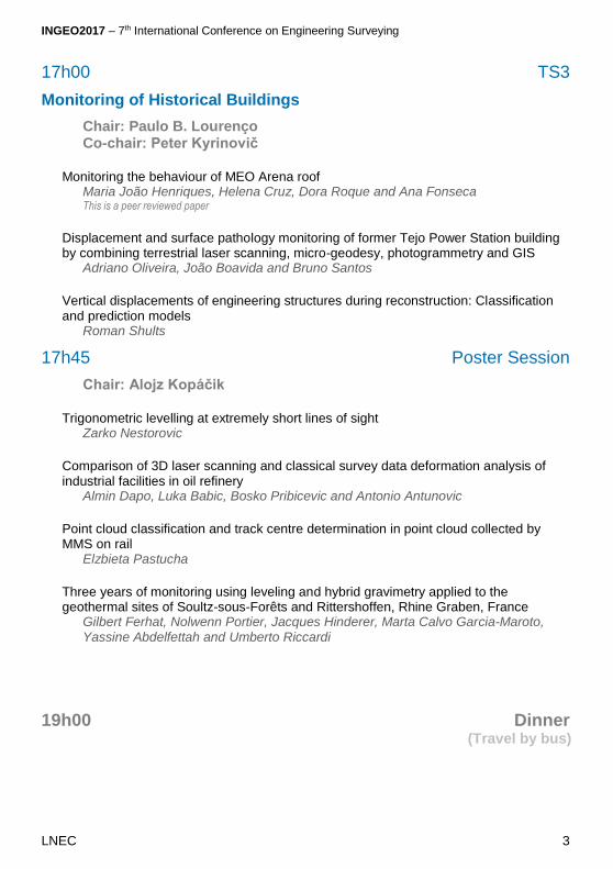
17h00 TS3
Monitoring of Historical Buildings
Chair: Paulo B. Lourenço Co-chair: Peter Kyrinovič
Monitoring the behaviour of MEO Arena roof Maria João Henriques, Helena Cruz, Dora Roque and Ana Fonseca This is a peer reviewed paper
Displacement and surface pathology monitoring of former Tejo Power Station building by combining terrestrial laser scanning, micro-geodesy, photogrammetry and GIS
Adriano Oliveira, João Boavida and Bruno Santos
Vertical displacements of engineering structures during reconstruction: Classification and prediction models
Roman Shults
17h45 Poster Session
Chair: Alojz Kopáčik
Trigonometric levelling at extremely short lines of sight Zarko Nestorovic
Comparison of 3D laser scanning and classical survey data deformation analysis of industrial facilities in oil refinery
Almin Dapo, Luka Babic, Bosko Pribicevic and Antonio Antunovic
Point cloud classification and track centre determination in point cloud collected by MMS on rail
Elzbieta Pastucha
Three years of monitoring using leveling and hybrid gravimetry applied to the geothermal sites of Soultz-sous-Forêts and Rittershoffen, Rhine Graben, France
Gilbert Ferhat, Nolwenn Portier, Jacques Hinderer, Marta Calvo Garcia-Maroto, Yassine Abdelfettah and Umberto Riccardi
19h00 Dinner (Travel by bus)

INGEO2017 – 7th International Conference on Engineering Surveying
4 Portugal | Lisbon | October 18 - 20, 2017
19th Oct., Thursday
9h00 TS4
Concepts, New Technology and Software Development I
Chair: Hans Neuner Co-chair: Ante Marendic
Fusion of laser-scan and image data for deformation monitoring – Concept and perspective
Andreas Wagner, Wolfgang Wiedemann and Thomas Wunderlich This is a peer reviewed paper
The influence of different LocataNet configurations on positioning accuracy Igor Grgac, Rinaldo Paar, Ante Marendic and Ivan Jakopec This is a peer reviewed paper
A new approach to long-distance EDM: using intermode beating of broadband ultrashort laser pulses
David Salido Monzú and Andreas Wieser This is a peer reviewed paper
Synchronization routine for real-time synchronization of robotic total stations Zan Gojcic, Slaven Kalenjuk and Werner Lienhart This is a peer reviewed paper
Deformation monitoring in the Internet of Things. Implementation of a multi-platform software package for modern sensor networks in engineering geodesy
Philipp Engel This is a peer reviewed paper
Coffee Break
11h00 PS3
Geotechnical Works / Ground Based Radar Interferometry
Chair: Ana Fonseca
The role of monitoring in geotechnical works Ana Quintela
Potential of Space Based and Ground Based Radar Interferometry for Deformation Monitoring
Wolfgang Niemeier

INGEO2017 – 7th International Conference on Engineering Surveying
LNEC 5
12h00 TS5
Monitoring of Geological and Hydrological Hazards
Chair: Ana Quintela Co-chair: Stella Pytharouli
Deformation monitoring of Kostanjek landslide in Croatia using multiple sensor networks and UAV
Ante Marendić, Rinaldo Paar, Hrvoje Tomić, Miodrag Roić and Martin Krkač This is a peer reviewed paper
Geodetic monitoring of the Adroit landslide, Barcelonnette, French Southern Alps Gilbert Ferhat, Jean-Philippe Malet, Anne Puissant, Delphine Caubet and Emilie Hubert This is a peer reviewed paper
Multi-method monitoring of the large and rapidly developping Pas de l'Ours landslide - Queyras, France
Floriane Provost, Pierrick Bornemann, Elouan Faustin, Jean-Philippe Malet, Clément Hibert, Anne Puissant, Marc Fleck, Gilbert Ferhat, Pascal Diot and Vincent Ségel
Lunch
14h00 PS4
Maritime Structures / Augmented Reality
Chair: Ana Fonseca
Application of stereo-photogrammetric methodologies to the design and monitoring of maritime structures
Conceição Juana Fortes
Virtual and Augmented Reality: from the Lab to the Wild Alfredo Ferreira

INGEO2017 – 7th International Conference on Engineering Surveying
6 Portugal | Lisbon | October 18 - 20, 2017
15h00 TS6
Monitoring of Coastal Structures
Chair: Conceição Juana Fortes Co-chair: José Nuno Lima
Towards a mobile monitoring tool for coastal structures inspection: The Ericeira rubble-mound breakwater test case
Rui Capitão, Alexandre Maia, Rute Lemos, Armanda Rodrigues and Conceição Juana Fortes This is a peer reviewed paper
The monitoring of rubble mound breakwaters. An assessment of UAV technology Maria João Henriques, Rute Lemos, Rui Capitão and Conceição Juana Fortes This is a peer reviewed paper
The use of UAVs in engineering geological surveys: mapping along Scotland’s south-west coast
Olympia Tziavou, Stella Pytharouli and Jock Souter
Survey of a two-dimensional scale model of a rubble-mound breakwater using different stereo-photogrammetric techniques
Rute Lemos, Maria João Henriques, António Muralha, Ricardo Jónatas, Conceição Juana Fortes and Rui Capitão This is a peer reviewed paper
Coffee Break
16h30 Visit to downtown Lisbon (Travel to the meeting point with the guides by subway)

INGEO2017 – 7th International Conference on Engineering Surveying
LNEC 7
20th Oct., Friday
9h00 TS7
Terrestrial Laser Scanning
Chair: Volker Schwieger Co-chair: David Salido Monzú
Evaluating the freeform modelling of point clouds by means of a test specimen Corinna Harmening, Gilles Teodori and Hans Neuner This is a peer reviewed paper
Using point cloud comparisons for revealing deformations of natural and artificial objects
Christoph Holst, Lasse Klingbeil, Felix Esser and Heiner Kuhlmann This is a peer reviewed paper
Geodetic surface based methods for applications in civil engineering Claudius Schmitt, Benjamin Kromoser, Corinna Harmening, Johannes Falkner, Hans Neuner and Johann Kollegger This is a peer reviewed paper
Simplicity is the New Black: The BLK360 Story Vanda Kadlečíková
TLS Data Georeferencing - Error Sources and Effects Jelena Pandžić, Marko Pejić, Branko Božić and Verica Erić This is a peer reviewed paper
Coffee Break
11h00 PS5
Bridge Monitoring / GNSS Applications
Chair: Alojz Kopáčik
Dynamic Response of Bridges and its Monitoring Needs Milan Sokol
GNSS: tools to monitor a dynamic Earth Virgilio Mendes

INGEO2017 – 7th International Conference on Engineering Surveying
8 Portugal | Lisbon | October 18 - 20, 2017
12h00 TS8
Radar Interferometry Applications
Chair: Heiner Kuhlmann Co-chair: Dora Roque
The use of InSAR technology to monitor ground and structural displacements Josep Raventos, Carles Couso and Javier Garcia This is a peer reviewed paper
Merging GBSAR and topographic surveys to measure pier deformations Giovanni Nico, Andrea Di Pasquale, Gianluca Miccoli and Filippo Maria Soccodato
Ground based Synthetic Aperture Radar (GBSAR) interferometry: which advantages for the monitoring of concrete and earth-filled dams?
Giovanni Nico, Marco Corsetti, Alfredo Pitullo and Andrea Di Pasquale
Lunch
14h00 PS6
Concrete Dams / UAV Applications
Chair: António Batista
The role of survey methods in the monitoring of concrete dams Domingos Silva Matos
Assessing exposure of infrastructure to natural hazards using unmanned aerial systems: case studies from the Andes, Portugal, Antarctica and Cape Verde
Gonçalo Vieira
15h00 TS9
Concepts, New Technology and Software Development II
Chair: Gonçalo Vieira Co-chair: Ján Erdélyi
Monitoring system using low cost GNSS sensors: first experiments and performance evaluation
Stefano Gandolfi, Luca Poluzzi and Luca Tavascih
A Bayesian procedure for analysis of short permanent GNSS baselines José Nuno Lima and João Casaca

INGEO2017 – 7th International Conference on Engineering Surveying
LNEC 9
Systematic error elimination of inertial sensors using rotating platforms Ľubica Erdélyiová, Pavol Kajánek and Alojz Kopáčik
Multi-sensor based augmented virtuality immersive technologies for large scale metrology applications
Theodoros Xenakis, Vassilis Gikas and George Kaisarlis
Assessment of accuracy of basic manoeuvres performed by an unmanned aerial vehicle during autonomous flights
Pawel Cwiakala
16h30 Closing Ceremony

Sponsors
Platinium
Gold
Silver