Program Feasibility Note for Reducing Emissions … Feasibility Note for Reducing Emissions from All...
65
Program Feasibility Note for Reducing Emissions from All Land Uses (REALU) activities in Bac Kan Province, Vietnam Lead Authors: Rohit Jindal, Do Trong Hoan, Hoang Minh Ha Additional Contributors: Bac Dam Viet, Nguyen Văn Trí Tín, Alba Saray Pérez Terán August 2011 AT
Transcript of Program Feasibility Note for Reducing Emissions … Feasibility Note for Reducing Emissions from All...

Program Feasibility Note for
Reducing Emissions from All Land Uses (REALU)
activities in Bac Kan Province, Vietnam
Lead Authors: Rohit Jindal, Do Trong Hoan, Hoang Minh Ha
Additional Contributors: Bac Dam Viet, Nguyen Văn Trí Tín, Alba Saray Pérez Terán
August 2011
AT

REALU Vietnam
2
Executive Summary Vietnam is one of the pilot countries for both Reducing Emissions from Deforestation and forest Degradation (REDD) and Reducing Emissions from All Land Uses (REALU) initiatives. Land use, land use change and forestry contributes 17-20% of the global greenhouse gas emissions. Recognizing the important role played by this sector in combating climate change, the United Framework Convention on Climate Change (UNFCCC) included REDD into the ongoing negotiations and formulated the Bali action plan at the 13th Conference Of Parties in 2007. Since then large scale initiatives have been taken up in several tropical countries focused on REDD and REDD+ (protection and conservation of existing forests including restocking and regeneration). These initiatives include the United Nations – REDD (UN-REDD) program, the Forest Carbon Partnership Facility, and the Forest Investment Program. The main thrust of the international effort on REDD+, however, has been on conserving forest areas without due consideration to carbon rich lands that lie outside the officially demarcated forestlands. A related concern is that in many tropical countries, significant tree cover lies outside the forest areas, while the officially demarcated forestlands may have little tree cover. Hence, the REALU approach that emphasizes the need for covering carbon emissions from land uses through a cross-sectoral landscape level planning, complements the ongoing REDD+ initiatives. Vietnam has seen a dramatic change in forest cover in the last 60 years. Although, the proportion of land under forest cover declined from 43% in 1943 to 20% in 1993, large scale plantations and forest regeneration since then increased the forest area to 13.564 million ha (representing 39% of the total land) in 2009. On average, the country has gained forests at more than 2% per annum over the last 20 years, making it one of the few tropical countries on the right side of the forest transition curve. However, the national figure masks wide variations in forest cover in different parts of the country. Deforestation is a major problem in Central Highlands, while significant forest cover is also being lost in the north central region. Similarly, coastal mangrove forests have witnessed a large scale deforestation, with an average decline of 15,000 ha/year between 1985 and 2000. Another related issue is of forest degradation. Even though forest cover has increased in many parts of the country, the quality of forests has not. While less than 1% of the land area is now under primary forests, more than 2/3rd of the natural forests are considered poor or regenerating. Forest conservation and management through REDD+ initiatives has ample scope at the national and sub-national level. The main agency to manage land is the Ministry of Natural Resource and Environment (MONRE) while the administration of forest and forestry land is under the Ministry of Agriculture and Rural Development (MARD). Both MONRE and MARD have corresponding departments at the province and district levels. The Government of Vietnam has taken several important initiatives to conserve forests and to decentralize forest management in the country. Although all land is owned by the state, under the 2003 Land Law and the Decision 181 passed in 2004 as part of the Forest Protection and Development Law, forest land can be allocated to local people in various forms: individual

REALU Vietnam
3
households, groups of households, and village communities. The forest land can be allocated in the form of ‘red book certificates’ for 50 years, renewable for another 50 years. Another important initiative is the Decision 380 introduced in 2008, under which local people can receive Payments for Forest Environmental Services (PFES). After the piloting of PFES in Lam Dong and Son La provinces, the program is now being planned for large scale replication throughout the country. Under PFES, the government is also establishing a Forest Protection and Development Fund (FPDF) which will channel public and private funding to local people for forestry activities. In order to calibrate the payments to local context, the government has envisaged ‘K coefficients’ that will determine the specific payment depending on the state of forests and other natural parameters. Both these initiatives have strong bearing on the scope of REDD+ program in Vietnam. Under a fair and effective Benefit Distribution System (BDS), the government is open to sharing international REDD+ revenue with local people that are involved in forest protection and management. The sub-technical working groups under the national REDD+ program are looking at the feasibility of establishing a sub-REDD fund under the FPDF that can provide payments to local people on the basis of REDD or ‘R coefficients’. However, there are concerns regarding the equity element especially when a large proportion of the population does not possess red book certificates. Another concern is how to balance the need for upfront benefits to community members
with performance based payments that are conditional on emission reduction. Other concerns include
the limitation of REDD payments in addressing drivers of deforestation that lie outside the forest areas
and in sufficiently compensating community members/forest managers for their opportunity costs.
Integrating REDD+ programs with the landscape level approach promoted by REALU can help address
many of these concerns. Instead of providing payments for only forest conservation activities, REALU
incentivizes community members for conserving all carbon rich land uses. In addition, cross‐sectoral
planning helps governments in formulating policies that are effective in addressing drivers of
deforestation, while providing long term incentives to community members to adopt sustainable land
use practices. Considering that the experience with REDD+ in Vietnam has been mainly limited to
national level, and that demonstration activities will be needed in the field to add momentum to the
present initiative, ICRAF Vietnam decided to focus the sub‐national activities under REALU to Bac Kan
province.
Feasibility of REALU in Bac Kan Bac Kan province is one of the most heavily forested (forest coverage is 56.6% compared to country
average at 39.1%) and poorest (poverty rate is 36.6% compared to country average at 13.4%) provinces
in Vietnam. It is also one of the potential candidates for the expansion of the UN‐REDD program under
phase II that will begin from 2012 onwards. ICRAF has significant field presence in the province including
a technical collaboration with International Fund for Agriculture Development (IFAD) funded Pro‐poor
Partnership for Agroforestry Development (3PAD) project and action research under Rewarding upland
poor for environmental services (RUPES) project.

REALU Vietnam
4
Feasibility assessment of REALU activities in Bac Kan province were carried out by ICRAF between
November 2010 and August 2011, and include:
• Province level workshops with government and NGO officials
• Review of government initiated conservation programs in the area
• Interviews and discussions with important stakeholders including the Chairman of the Provincial
People’s Committee (PPC) and the head of the Department for Rural Development (DARD).
• Secondary data collection and analysis
• Participatory rural appraisals in selected communities
• Technical surveys (carbon assessment, net present value of different land uses, reference emission
level).
The total population of Bac Kan province (2009) is 295,300 with the main ethnic communities being Tay,
Kinh, and Dao. Agriculture and forestry are the main sources of livelihoods. The main drivers of
deforestation are agriculture (slash and burn, mono‐cropping) and illegal logging. The two main special
use forests in the province are the Ba Be National Park and the Kim Hy Nature Reserve. Although the
PFES activities under Decision 99 and the operation of the FPDF are yet to begin, the province is involved
in payments for environmental services (PES) activities through the 3PAD project funded by IFAD. The
collaboration between ICRAF and 3PAD offers opportunities for testing the feasibility of carbon
payments under REALU in the field, which can then be replicated by the concerned agencies in other
parts of the province.
Stakeholder workshops and consultations with government agencies (DARD, 3PAD, representatives of
other agencies) reveal that provincial staff is largely unaware of the REDD+ processes. However,
considering the strong potential for forest management in the province, most staff members are willing
to learn and have expressed willingness to look at ways to integrate a landscape level approach into the
pilot REDD+ activities. Discussions on fair and effective benefit distribution system have also focused on
the potential for providing land tenure through red book certificates as an incentive under REDD/REALU
activities. Existence of the Community Development Fund (CDF) under the 3PAD project offers another
opportunity for incentivizing forest management efforts through creation of a revolving fund at the
community level. Another related aspect is the need to integrate remote sensing based monitoring,
reporting, and verification (MRV) with participatory carbon monitoring which will help create awareness
as well as ownership of the REDD/REALU process.
In terms of the Reference Emission Level (REL), data on forests and carbon stock show that between
1990 and 2010, the province gained a significant amount of forest cover due to large scale plantation
activities. From 190,298 ha of forests under different categories in 1990, the forest cover increased by
almost 60% to 304,170 ha in 2010. Similarly, the total carbon stock (above ground) increased from 20
million tons in 1990 to 27 million tons of carbon in 2010. This means that a provincial level REDD+
program cannot be based on historical deforestation alone, since the province has consistently added

REALU Vietnam
5
forest cover in the last two decades. Going in the past beyond 1990 may be unfeasible due to paucity of
reliable data while creating a hybrid baseline that accommodates both deforestation and afforestation
will need close scrutiny. The data also highlight the need to collect higher resolution remote sensing
images that can capture forest degradation; even if the total forest cover has increased, several areas
have witnessed a reduction in canopy cover due to illegal logging or clearing of forest areas for setting
up agricultural fields. In terms of opportunity cost analysis, most of the land use change emissions are
associated with opportunity cost of less than zero which implies that immediate income has been
prioritized over long term income. The threshold value below which almost all the land use based
emissions can be reversed is $5 /ton of carbon dioxide (tCO2). Again, more detailed data are being
collected through questionnaires with farmers to understand the reasons behind their land use change
decisions and implications for a carbon regime in the province.
Na Ri District, Bac Kan
In order to assess the field level application of REALU, Na Ri district was chosen for taking up pilot
activities in the near future. Like several parts of the province, Na Ri district has a high forest cover, with
about 70% of the land under some kind of forest cover. The district also has the newly created Kim Hy
Nature Reserve covering 18,555 ha. According to the field surveys carried out by ICRAF, slash and burn
agriculture and mono‐cropping are the main sources of forest degradation in the district. Na Ri district
offers a strong opportunity for taking up pilot REALU activities due to two main reasons:
• It is one of the three main district where the IFAD funded 3PAD project is testing innovative PES
models (the other two being Ba Be and Pac Nam).
• Two village communities of Na Muc and To Dooc are among the first few communities in Vietnam to
receive red book certificates for the sustainable management of the commune forests. This
demonstrates the readiness of the village communities to protect and conserve their local forests
after receiving secure tenure rights. A long term forest management plan under a prospective
REALU pilot in these communities offers potential for wider testing in other parts of the province
and the country.
In terms of REL, similar to the province as a whole, the total forest cover in Na Ri increased from 46,190
ha in 1990 to 58,882 ha in 2010. Similarly, the estimated above ground carbon stock increased from
4,410,214 tons in 1990 to 5,362,115 tons in 2010. However, these figures are based on coarse data and
higher resolution data will be needed to document forest degradation and the resultant changes in
carbon stock.
Within Na Ri, the feasibility of pilot REALU activities was carried out in Na Muc and To Dooc villages. As
part of the feasibility exercise, discussions were carried out with the commune level staff including the
respective chairmen of the commune level peoples’ committees. Focus groups with village
representatives, participatory poverty mapping, and transect surveys helped to understand the layout of
the two villages and potential for REALU activities. The three main land uses identified for REALU
activities are:

REALU Vietnam
6
• Conversion of open grazing into well fenced grasslands from which local households can cut and
carry fodder. This will help increase the carbon stock from zero to an average of 1.51 tons of
carbon/ha (tC/ha). This activity will also help address the fodder need in the area by improving the
productivity of the grasslands.
• Converting private upland maize fields to agroforestry where maize will be intercropped with Xoan
trees (Melia spp.) helping to increase the carbon stock from zero to 10.70 tC/ha. This activity will
address an important driver of deforestation – the need for firewood which cannot be met only
from the private production forests and so local people cut down trees in the commune forests. It
will stabilize mountain slopes and the resultant carbon revenue will provide an additional source of
income.
• Enhanced protection, restocking and management of commune forests helping to increase the
carbon stock from 60.63 tC/ha to 88.40 tC/ha (above ground). Although the commune forest in the
village is better protected than in many other local villages, illegal felling and intrusion from
neighboring villages results in sub‐optimal carbon stock. A more comprehensive management plan
that includes scope for restocking commune forests through regeneration and replantation, as well
as negotiation with neighboring villages on building norms around forest use will help sustain the
carbon stock in the long run.
During a stakeholder consultation in Bac Kan province in June 2011, community representatives
expressed willingness to participate in REALU activities. ICRAF is now carrying out a more detailed
investigation in the area to prepare a specific plan of REALU activities that will be implemented by the
3PAD project. An important focus of this plan is to come up with a fair and effective benefit distribution
system that includes the use of the community development fund of VND 30 million available for the
village. As part of the institutional arrangements, 3PAD officers will directly work with the village level
management board inTo Dooc with the involvement of commune level staff wherever necessary.
Since the scale of operations in To Dooc village will be too small to monitor through remote sensing
alone, ICRAF is working on a participatory carbon monitoring system. Under this system, a training
manual is being written that lays down principles and objectives behind participatory carbon monitoring
as well as detailed steps on how community members can carry out simple biomass surveys in the field
to monitor the changes due to REALU activities. ICRAF scientists will use this manual to train
representatives of the 3PAD staff as well as members of the village management boards in how to carry
out carbon surveys in the field. This participatory carbon monitoring system will also be integrated with
the province level remote sensing based MRV system that ICRAF will develop in collaboration with the
Michigan State University. Results and experience from field level pilot activities will be shared at the
province and the national level to backstop REDD+ activities in Vietnam. Several related research
activities will also be carried out which include an in‐depth review of the relationship between land
tenure process and REDD+ design in Vietnam, socio‐economic impact assessment of carbon payments
under REDD+/REALU, estimating opportunity costs of forest management in different parts of the
country, and developing fair and effective benefit distribution system.

REALU Vietnam
7
Major opportunities The feasibility exercise for REALU activities at the sub-national level in Bac Kan province highlights several important opportunities: • Willingness of the provincial government agencies to collaborate with ICRAF will help in
increasing awareness on the advantages of integrating landscape approach promoted under REALU with the REDD+ activities that are due to follow as part of the UN-REDD program in the country.
• The ongoing technical collaboration between ICRAF and IFAD’s 3PAD project will not only help in pilot testing REALU activities in the field, but will also create opportunity for their wider replication in other 3PAD areas.
• Similarly, the field experience in To Dooc village will not only help in Documenting the potential of REALU in promoting sustainable land use, but also in identifying major constraints in addressing drivers of deforestation. The pilot REALU program will also test the feasibility of participatory carbon monitoring in increasing the community’s stake in carbon management activities as well as the potential for generating reliable data on changes in carbon stocks.
• Existence of Kim Hy reserve adjacent to REALU pilot sites as well as Ba Be National park in Ba Be district will help test the potential for scaling up forest management activities in special use forests, both within Bac Kan province and in other parts of the country. This assumes significance under Decision 99 whereby forest managers could receive payments for providing valuable environmental services. In many areas, however, water and ecotourism payments will be quite low, but could be bundled with the carbon payments under the REDD+ program thus creating a more holistic and sustainable PES program.
• ICRAF’s collaboration with PPC, DARD, IFAD, and other government agencies offers opportunity to backstop government’s REDD+ program and to facilitate in formulating policies that assist in cross-sectoral planning.
• ICRAF’s existing capacity on REDD+: RESFA (REDD+/REALU Site Feasibility Assessment), RaCSA (Rapid Carbon Stock Appraisal), and PES experiences and studies in conjunction with RUPES project.
Challenges One of the main challenges in promoting REDD/REALU among local communities is the creation of fair and effective benefit distribution system (BDS) that incentivizes forest managers for investing in conservation. Such a system will need to balance between community’s need for immediate benefits with the program objective of offering conditional, performance based payments. BDS is one of the focal areas for the on-going research under UN-REDD program in Vietnam and will be a core challenge to address under REALU activities in Bac Kan province. A related challenge is of tenure security and rights to carbon stock. Under the 2003 Land Law and the 2004 Forest Protection and Development Law, forestland has been allocated to households and village communities through red book certificates. However, a vast proportion of the population still has insecure land tenure which will limit their claims to carbon payments under a

REALU Vietnam
8
REDD+ regime. Addressing this challenge will be important for ensuring that REDD and REALU activities are beneficial for everyone. A possible alternative is to provide carbon rights even if the land rights are unclear. This is a policy question which is currently being debated at the national level and the pilot REALU activities in Bac Kan may provide useful insights on the question of land and carbon rights for the local communities. REALU promotes a landscape level approach. Although many resource management initiatives such as watershed management have associated physical units such as a micro-watershed, defining a specific landscape unit for carbon activities is difficult. This has implications for both planning carbon management activities as well as for devising sub-national level MRV system since it is difficult to define a clear cut boundary that differentiates project areas from non-project areas. For the present, the REALU pilot will focus on three main carbon rich land uses in selected villages in Na Ri district of Bac Kan province. However, this may be insufficient when government agencies decide to replicate carbon management on a wider scale. Defining a viable unit of landscape for planning and implementation will therefore be an important challenge for REALU. In specific case of Bac Kan province where forest area has actually increased over the past 20 years, the conventional system of estimating the reference emission level may no longer be appropriate. In addition, even the business as usual scenario will be inadequate since it penalizes communities and governments for conservation action already taken. Although the REALU approach that takes into account carbon dynamics on all land uses helps in creating incentives for carbon management outside the forest areas, it does not help solve the question on REL. Instead, wider policy level discussions are needed for areas that have actually gained carbon stock in the recent past, but remain susceptible to its loss due to socio-economic pressures. Constraints A major constraint in promoting carbon rich land uses is the dichotomy between valuing environmental services and yet not being able to compensate the opportunity cost of conservation. REDD/REALU and its precursor Clean Development Mechanism (CDM) were based on creating sustainable development benefits for tropical countries by monetizing carbon stored in local forests. However, due to global geopolitics, the price of carbon in international markets, especially of forest carbon in voluntary markets remains subdued and cannot adequately compensate the opportunity cost of establishing long term carbon contracts. At the project level, availability of capable staff that can carry out REALU related activities and research, remains an important constraint. ICRAF is trying to address this concern by recruiting international staff, as well as through regular trainings and workshops for its in-house staff as well as for staff members of other government and NGO agencies that are involved in REDD+ activities.

REALU Vietnam
9
List of Acronyms
BDS Benefit Distribution System CDM Clean Development Mechanism CFM Community Forest Management CIFOR Centre for International Forestry Research CoP Conference of the Parties CPC Commune Peoples’ Committee DARD Department of Agriculture and Rural Development DoF Department of Forestry DPC District Peoples’ Committee FCPF Forest Carbon Partnership Facility FIPI Forest Inventory and Planning Institute FLEG Forest Law Enforcement and Governance FLEGT Forest Law Enforcement, Governance, and Trade FPD Forest Protection Department FPDF Forest Protection and Development Fund FPU Forest Protection Unit GoV Government of Viet Nam ICRAF World Agroforestry Center JICA Japanese International Cooperation Agency MARD Ministry of Agriculture and Rural Development MODIS Moderate Resolution Imaging Spectroradiometer MoF Ministry of Finance MONRE Ministry of Natural Resources and the Environment MoU Memorandum of Understanding MPI Ministry of Planning and Investment MRV Measurement, Reporting and Verification NGO Non-governmental Organization PAMB Protected Area Management Board PES Payment for Ecosystem Services PFES Payment for Forest Ecological Services PFMB Management Board for Protection Forest PPC Provincial Peoples’ Committee PRA Participatory Rural Appraisal RaCSA Rapid Carbon Stock Appraisal REDD Reducing Emissions from Deforestation and Forest Degradation R-PIN Readiness Project Identification Note SEDP Social and Economic Development Plan SFE State Forest Enterprise SNV Stichting Nederlandse Vrijwilligers (Netherlands Development Agency) SOC State-Owned Company

REALU Vietnam
10
TFF Trust Fund for Forests UNFCCC United Nations Framework Convention on Climate Change UNREDD United National Program to Reduce Emissions from Deforestation and
Forest Degradation VER Verified Emission Reductions 5MHRP 5 Million Hectare Reforestation Program or 661 Program

REALU Vietnam
11
1. Introduction Land use, land-use change, and forestry (LULUCF), contributes 17-20% of the global greenhouse gas emissions. Immediate curtailing of all these emissions is difficult due to social and economic pressures. However, a significant percentage can be reduced by compensating land managers for investing in forest management, for example for not clearing forests to create agricultural fields. This is the principal rationale behind global efforts on Reducing Emissions from Deforestation and Forest Degradation (REDD). Recognizing the important role played by the LUCUCF sector - especially tropical forests - in combating climate change, the United Framework Convention on Climate Change (UNFCCC) formulated the Bali action plan at the 13th Conference Of Parties in 2007 to include REDD as part of the strategy to reduce the excess built up of greenhouse gases in the atmosphere. Since then large scale initiatives have been taken up in several tropical countries focused on REDD and REDD+ (protection and conservation of existing forests including restocking and regeneration). These initiatives include the United Nations – REDD (UN-REDD) program, the Forest Carbon Partnership Facility (FCPF), and the Forest Investment Program. Vietnam is actively involved in many of these programs indicating its commitment to help mitigate climate change. The country received $4.4 million from the UN-REDD program in 2009 to formulate a national REDD+ strategy for effective conservation of its forests. In order to generate consensus around important aspects of REDD such as benefit distribution system and monitoring reporting and verification, the national REDD directorate has formed different sub-technical working groups consisting of government staff, researchers, and representatives from various NGOs (www.un-redd.org). The government is now expanding this program by planning pilot REDD+ activities in selected provinces where deforestation pressure is high. Vietnam has also submitted a proposal to FCPF which is currently under review. In addition, many national and international organizations are also active in either research or pilot REDD activities in different parts of the country (see annex 1 for details). An important limitation of the current REDD+ efforts at both global and national level (including
Vietnam) however, is their focus on only forestry sector without due consideration to drivers of
deforestation that may lie outside the forests or not accounting for changes in carbon stocks outside the
officially demarcated forestlands. This can be a serious limitation to effectiveness of REDD+ regimes in
reducing carbon emissions especially in tropical countries where forest dynamics is intricately linked
with the wider natural resource sector. A complementary approach in this regard is Reducing Emissions
from All Land Uses (REALU) under which carbon dynamics both inside and outside forests are covered.
The key differences between the REALU approach and REDD+ are: (i) piloting payment mechanisms that
cover not only “forest trees” but also “trees outside forest” to simultaneously achieve livelihoods
improvement and emission reduction; (ii) applying a landscape approach and alternatives to avoid
leakages; (iii) addressing drivers of deforestation and degradation comprehensively by encouraging
alternatives, and therefore reducing pressures on forest resources; and (iv) mainstream REDD+ into
sustainable rural development strategy.
REALU Vietnam
12
The international project on Architecture of REALU, funded by the Norwegian Agency for Development Cooperation (NORAD), was designed to: (i) provide analyses of key cross‐sectoral linkages in the tropical forest margins, based on long‐term engagement in Asia, Africa and Latin
America; (ii) organize multi stakeholder events to explore implications for the design of an effective
regime in the post‐2012 Kyoto context; and (iii) build the scientific and political basis for change through
communicating and networking activities. The project is coordinated by the Alternatives for Slash and
Burn (ASB) network in four developing countries: Indonesia, Vietnam, Cameroon, and Peru. An
important component of the project is backstopping REDD+ processes at various levels in order to add
momentum towards a high carbon stock/development pathway. Therefore, within each of the four pilot
countries, the national REALU teams are working in collaboration with the national and sub‐national
REDD+ programs to promote effective and sustainable land use management regimes. As part of this
process, REALU teams have prepared feasibility plans for piloting REALU activities in the field in order to
demonstrate the viability of integrating a landscape level approach into REDD+ to policy makers and
other relevant stakeholders. Following is a feasibility plan for sub‐national piloting of REALU in Vietnam.
2. Data and methods
Data for the feasibility assessment were collected through multiple methods starting with a national
level workshop on REALU in Hanoi in November 2010 and continued through several rounds of
stakeholder consultations, field surveys, group discussions, and participatory rural appraisals (PRA) at
different levels. These included (please see table 1):
• National and provincial level workshops with government officials, NGO representatives, and
researchers from national universities.
• Desk and field review of government initiated conservation programs in Bac Kan, Lam Dong, and Son
La provinces.
• Interviews and discussions with important stakeholders including the Head of Vietnam Forests, Head
of the national REDD+ program, Chairman of the Provincial People’s Committee (PPC) in Bac Kan
province, and the Head of the Department for Rural Development (DARD) in Bac Kan province.
• Secondary data collection from relevant government ministries, local agencies, and commune level
offices.
• Participatory rural appraisals in selected communities of Bac Kan province, especially Na Muc and To
Dooc villages. These PRA exercises included participatory poverty assessment, transect walks,
household questionnaires, and village mapping exercises.
• Technical surveys (carbon assessment, net present value of different land uses, reference emission
levels, forest inventory) in Bac Kan province.

REALU Vietnam
13
Table 1: Kinds of data collected for the feasibility assessment
Level Methods Kind of data Main respondentsNational (Hanoi)
• REALU workshops • Desk/literature review • Secondary data
• Main issues in REDD+ • Lessons learnt on existing govt.
programs • Biophysical data for REALU
development
MARD, MONRE, members of the REDD+ sub-technical groups, NGOs, universities
Province & District
• Stakeholder workshops
• Semi-structured interviews (individuals and groups)
• Secondary data
• Status of govt. programs • Institutional set up • Status of forests and carbon
stock • Socioeconomic data for REALU • Experience with forest/land
issues
DONRE, DARD (FPD, FD), 3PAD, legal departments, Provincial People’s Committee.
Commune
• Stakeholders workshops
• Semi-structured interviews
• Secondary data
• Commune level socioeconomic data
• Data on land use in the commune
• Consensus of relevant REALU issues
CPC: head of CPC, cadastral officers, agriculture and forestry officers.
Village • Semi-structured interviews
• PRA exercises • Questionnaires
• Existing Land Uses and local perspective on REALU intervention
• Socioeconomic data • Experience with previous
development interventions
Village leader, individual households, community representatives.
3. Status of forests in Vietnam Vietnam has seen a dramatic change in forest cover in the last 60 years (see annex 2 for official definition of forest in Vietnam). Although, the proportion of land under forest cover declined from 43% in 1943 to 20% in 1993, large scale plantations and forest regeneration since then increased the forest area to 13.564 million ha (representing 39% of the total land) in 2009. On average, the country has gained forests at more than 2% per annum over the last 20 years, making it one of the few tropical countries on the right side of the forest transition curve (see figure 1 below). However, as shown in figure 1, the national figure masks wide variations in forest cover in different parts of the country. Another related issue is of forest degradation. Even though forest cover has increased in many parts of the country, the quality of forests has not. While less than 1% of the land area is now under primary forests, more than 2/3rd of the natural forests are considered poor or regenerating.

REALU Vietnam
14
According to the forestry data collected by the Government of Vietnam, large scale deforestation and forest degradation has been reported in the Central Highlands, the eastern part of the southern region and the Central coastal provinces. Between 2000 and 2005: • The Central Highlands lost a net forest area of 118,984 ha, equivalent to 4% of forest area
in 2000. During the same period of time, the total timber volume in the region declined from 317,794,000 m3 to 288,559,000 m3.
• The eastern part of the southern region experienced rapid deforestation losing 86,872 ha or 8.6% of its natural forest cover. About 110,758 ha of evergreen broadleaved forests, mixed deciduous forests, coniferous forests, and mixed coniferous and broadleaved forests in this region were cut.
• North West and North East Vietnam lost most of their lowland forests with the evergreen broadleaved forests in this region severely degraded. In 2005, the timber volume of the evergreen broadleaved forest was only 20.8 m3 /ha compared to 135 m3/ha in the Central Coastal region.
• Similarly, coastal mangrove forests witnessed a large scale deforestation, with an average decline of 15,000 ha/year between 1985 and 2000.
The main drivers of deforestation and forest degradation in Vietnam have been identified to be: • Conversion of forest area to agriculture particularly for industrial perennial crops, • Illegal logging, • Infrastructure development, particularly for road construction and building of hydropower
dams, • Forest fires Figure 1: Forest transition curve (Government of Vietnam; adapted from Angelsen, 2007)

REALU Vietnam
15
Addressing these drivers through a comprehensive forest conservation and management program under REDD+ therefore, has ample scope in Vietnam. Recognizing this potential, the Government of Vietnam has been an active participant in international efforts to promote REDD processes; in 2008, Vietnam was selected as a participant in the Forest Carbon Partnership Facility (FCPF) and in 2009 it was selected as the first country in the world to pilot the United Nations Collaborative Program on Reducing Emissions from Deforestation and Forest Degradation in developing countries (UN-REDD). 3.1 Forest governance in Vietnam The state administration of forest and forestry land in Vietnam is Ministry of Rural Development (MARD). Within MARD, two departments are in charge of forestry issues - Department of Forestry (DoF) and Forest Protection Department (FPD): • DoF is responsible for forest management, utilization and development. Within DoF, there
are three technical divisions responsible for forest management, forest development, and forest utilization.
• FPD is in charge of forest protection and forest law enforcement. Technical divisions within FPD include division of forest protection, division of nature conservation, division of legal inspection, and a special task force.
At the provincial level, the Department of Agriculture and Rural Development (DARD), which is the line agency of MARD and a member of Provincial Peoples Committee (PPC), is in charge of forestry issues. The sub-department of forestry and sub department of forest protection (the line agencies of DoF and FPD respectively) are under DARD. At the district level, the economic division (or the agricultural division in some cases) is responsible for forest management, utilization and development. At the commune level, there is one agriculture and forestry official based in Commune Peoples Committee (CPC). The land management agency at central level is the Ministry of Natural Resource and Environment (MONRE), which has responsibilities related to the allocation of land to households, including forestry land. Similar to MARD, MONRE has line departments – Department of Natural Resources and Environment (DONRE) at the provincial, district and commune levels (see figure 2 below for institutional setup at the province level).

REALU Vietnam
16
Figure 2: Institutional setup at the province level
PPC - Establish Provincial Steering Committee: DARD, DONRE, FPD, DOF, DPI
- Coordinating PES activities at provincial and district level.
DARD - Forest
management, administration of
Forest Inventory
Board
DPI - Socio-economic
planning
DONRE - Land use
administration
National Park FPD - Forest Protection and Management
FD - Forest
development and l t ti
District National Park Staff
District FPD
Forest Stations
Commune Forester
Forest Enterprise / Production
F t
Forest Management
Board
District DONRE
Commune Cadastral/Land
Use Officer
District DPI

REALU Vietnam
17
Forest resources in Vietnam are managed by eight major groups of actors: (i) State-owned companies (SOCs): are set up and owned by the state to manage forest
primarily for production purposes. SOCs may also be responsible for management of protected forests.
(ii) Protected area management boards: PAMBs have the task to manage special use forests identified for their high environmental, biodiversity or cultural significance, including National Parks.
(iii) Other economic entities: In charge of safe-guarding the protection forests and commercializing the production forests allocated to them, e.g. joint-venture companies working in forestry field.
(iv) Individual households: Households that have received forest land titles from the state. These are different from households that are contracted by various state agencies (SOCs, PAMBs) for forest protection but without any land title.
(v) Communities: that have received forestland with official land title. (vi) Other organizations: e.g. Youth Union, Women’s Union, and Farmers’ Associations that
receive forest land along with titles. (vii) Armed forces: in charge of forest areas mainly for national security purposes. (viii) Communal people’s committees: CPCs serve as temporary custodians of forest areas that
were formerly managed by SOCs and which are in the process of being allocated to other stakeholders (e.g. households or communities). CPCs therefore do not have full tenure rights to the forest areas under their management.
3.2 Forest management policies in Vietnam Since 1990s, several policies and programs have been introduced in Vietnam to encourage forest protection and regeneration. In 1992, the government launched Program 327 aimed at greening barren mountain slopes. This was followed by the much larger Five Million Hectares Reforestation Program (5MHRP) or the ‘661 program’. The aim of the program was to increase the forest cover in the country by 43% of the total land by 2010. Of the five million hectares, two million hectares were planned as protection forests and three million hectares as production forests. Subsequently, Program 147 was introduced with a focus on development of forest plantations (2007�2015). Among the several other initiatives taken by the Government of Vietnam in recent years, two stand out for their direct relevance for REDD+ processes in the country. One is about land tenure and the other is about initiating a national program on payments for environmental services (PES). Although all land is owned by the state, under the 2003 Land Law and the Decision 181 passed in 2004 as part of the Forest Protection and Development Law, forest land can be allocated to local people in various forms: individual households, groups of households, and village communities. The forest land can be allocated in the form of ‘red book certificates’ for 50 years, renewable for another 50 years. However, by 2006, only 55% of land classified as

REALU Vietnam
18
forestland had been allocated to households based on land use rights certificates as compared to 81% for agriculture land. Currently, state enterprises, individual households, and People’s Committees are the three largest tenure holders (figure 3). Policies to allocate forest land and to increase forest coverage have been accompanied by initiatives to strengthen forest management through programs such as the Community Forestry Management Pilot Program in 2006. Such initiatives highlight the growing interest and move towards community forestry in Viet Nam. Figure 3: Forest tenure holders in Viet Nam (Source: Nguyen, 2006)
Another important initiative is the Decision 380 (introduced in 2008) and its successor Decree 99 introduced in 2010, under which local people can receive Payments for Forest Environmental Services (PFES). After the piloting of PFES in Lam Dong and Son La provinces, the program is now being planned for large scale replication throughout the country. Under PFES, the government is also establishing a Forest Protection and Development Fund (FPDF) which will channel public and private funding to local people for forestry activities. In order to calibrate the payments to local context, the government has envisaged ‘K coefficients’ that will determine the specific payment depending on the state of forests and other natural parameters. Both these initiatives – forestland tenure and PFES – have strong bearing on the scope of REDD+ program in Vietnam. Under a fair and effective Benefit Distribution System (BDS), the government is open to sharing international REDD+ revenue with local people that are involved in forest protection and management. The sub-technical working groups under the national REDD+ program are looking at the feasibility of establishing a sub-REDD fund under the FPDF that can provide payments to local people on the basis of REDD or ‘R coefficients’. However, there are concerns regarding the equity element especially when a large proportion of the population does not possess red book certificates. Another concern is how to balance the need for
upfront benefits to community members with performance based payments that are conditional on
emission reduction. Other concerns include the limitation of REDD payments in addressing drivers of

REALU Vietnam
19
deforestation that lie outside the forest areas and in sufficiently compensating community
members/forest managers for their opportunity costs.
Integrating REDD+ programs with the landscape level approach promoted by REALU can help address
many of these concerns. Instead of providing payments for only forest conservation activities, REALU
incentivizes community members for conserving all carbon rich land uses. In addition, cross‐sectoral
planning helps governments in formulating policies that are effective in addressing drivers of
deforestation, while providing long term incentives to community members to adopt sustainable land
use practices. Considering that the experience with REDD+ in Vietnam has been mainly limited to
national level, and that demonstration activities will be needed in the field to add momentum to the
present initiative, ICRAF Vietnam decided to focus the sub‐national activities under REALU in Bac Kan
province.
Bac Kan was chosen for REALU II activities at sub‐national level for the following reasons: (1) The
province is heavily forested (forest coverage is 56.6% compared to country average at 39.1%) and poor
(poverty rate is 36.6% compared to country average at 13.4%); (2) It is the action research site for
ICRAF’s RUPES project (Rewarding upland poor for environmental services) since 2008, and a number of
research projects using participatory rural appraisals have been conducted in Ba Be district since 2009;
(3) ICRAF has significant field presence in the province including a technical collaboration with
International Fund for Agriculture Development (IFAD) funded Pro‐poor Partnership for Agroforestry
Development (3PAD) project; (4) According to the draft proposal submitted by Government of Vietnam in August 2011, Bac Kan is a potential candidate for piloting carbon payments under the
proposed UN‐REDD phase II program in Vietnam . The following sections discuss the feasibility of
undertaking pilot REALU activities in the province, especially in the selected villages of Na Muc and To
Dooc in Na Ri district in a way to complement the UN‐REDD activities at the provincial and the national
level.
4. Bac Kan Province
Bac Kan province is located in the northeast mountainous region of Vietnam ‐ between 21o 48’N to 22o
44’ N, 105o 26’E to 106o 15’E, about 170 km to the north of Hanoi, and about 200 km south of the border
with China (see figure 4). It borders four other provinces, i.e. Lang Son (to the east), Cao Bang (to the
north), Tuyen Quang (to the west) and Thai Nguyen (to the south). 90% of the province is mountainous
and the terrain is divided by streams and rivers, the important ones being ‐ Nang River, Cau River, Bac
Giang River, and Hien River. There are three large nature reserves, i.e. Ba Be National Park, Kim Hy
Nature Reserve, and Nam Son Moc Nature Reserve that together cover about 26,000 ha of special use
forests. The average elevation of the province is 500‐600 meters above sea level, with the highest point
being 1,640 m in the Nam Hoa Son mountain. The average annual rainfall is 1400 – 1600 mm, 70% of
which falls in hot‐humid‐rainy season from May to October, while the rest is received during the
relatively dry season from November to April of next year. According to the General Statistics Office of

REALU Vietnam
20
Vietnam, the total population of the province is 295,300 living in an area of 4,861 km2 with an average
density of 61 persons/ km2 (www.gso.gov.vn). Administratively, the province is distributed into seven
districts, the town of Bac Kan, and 122 communes. Among the 7 ethnic groups in the province, the Tay
form 60.4% of the total population, Kinh 19.3%, Dao 9.5%, and Nung 7.4%.
Figure 4. Bac Kan Province
Most residents in the province are poor with the average annual income per capita in 2007 being US$
309 (VND 4.95 million). At the province level, there has been a significant restructuring in the economy
with agriculture, forestry and fishing now contributing only 39.6% of the province’s total GDP in 2009 as
against more than 60% only ten years ago (table 2). Both the industrial and the service sector have
registered an impressive growth and they now contribute 60% of the GDP of the province.
Table 2. Economic restructuring in Bac Kan province from 2000‐2009 (% contribution to GDP)
Economic sector 2000 2005 2009
Agriculture, forestry and fishing 62.66 47.77 39.60

REALU Vietnam
21
Industry and construction 9.81 19.67 26.47
Service 27.53 32.56 33.93
(Source: Bac Kan Statistical Yearbook)
In rural areas however, agriculture and forestry are still the main sources of livelihood. Out of the total
planted area of 59, 385 ha, the bulk is taken by food crops followed by industrial crops (table 3). Paddy
rice and maize are the two main crops both for home consumption and for earning cash income (see
annex 3 for area and yield of major crops grown in the province). In terms of output, the total value of
agricultural output in the province increased from VND 265 billion in 2000 to VND 432.6 billion in 2009
at 1994 prices (GoV, 2009).
Table 3. Planted area under different crops in Bac Kan (ha)
Planted area 2006 2007 2008 2009
Total area 55,321 57,855 60,254 59,385
Food crops 35,013 37,368 37,980 37,858
Annual industrial crops 3,656 3,656 3,915 4,298
Perennial industrial crops 8,497 8,634 8,991 8,388
Fruit crops 3,959 3,743 3,873 3,574(Source: Bac Kan Statistical Yearbook)
4.1 Land use change in Bac Kan
As we discussed in section 3.1 above, the two main government agencies responsible for managing land
including forests are the Department of Agriculture and Rural Development (DARD) and the Department
of Natural Resources (DONRE), both of which are members of the Provincial People’s Committee (PPC)
(figure 2). Although both departments maintain data on land use, their classification is different.
According to DONRE, between 2000 and 2010, agricultural land increased by 80,813 ha mainly due to
reclassification and reclamation of unused land (table 4). Similarly, during the same period, productive
forest increased by 82,805 ha from 163,032 ha in 2000 to 245,837 ha in 2010. Area under specially used
forest first increased from 21,930 ha in 2000 to 23,376 ha in 2005, it fell down to 21,988 ha in 2010.
Protective forest, on the other hand, decreased consistently from 116,756 ha in 2000 to 107,512 ha in
2010 (figure 5). Overall, however, out of the total land area of about 485,900 ha in the province, area
under various kinds of forests increased from 62.12% in 2000 to 68.54% in 2005 and further to 77.24% in
2010 (figure 6). This shows the remarkable growth in area under forests, due mainly to large scale
plantation projects such as the 661 program or the 5 million hectare reforestation program (5MHRP). In
order to look at changes in forest area in detail and understand their implications for a potential REDD+
program in Bac Kan, we next turn to forest data managed by DARD.

REALU Vietnam
22

REALU Vietnam
23
Table 4. Changes in land use area in Bac Kan during 2000‐2005 and 2005‐2010 (in ha)
Land use purpose
Year Increase (+),
Decrease (‐) in
the period
2000‐2005
Increase (+),
Decrease (‐)
in the period
2005‐2010 2000 2005 2010
Total land area 485721 485941 485941 220
Agricultural land 332231 371767 413044 39536 41277
Agricultural production land 30023 37798 36650 7775 ‐1148
Annual crop land 25959 32536 31338 6577 ‐1197
Paddy land 17041 19180 18563 2139 ‐617
Other annual crop land 8918 13356 12776 4438 ‐580
Perennial crop land 4064 5262 5312 1198 50
Forestry land 301718 333059 375337 31341 42278
Productive forest 163032 198576 245836 35544 47261
Protective forest 116756 111107 107512 ‐5649 ‐3595
Specially used forest 21930 23376 21988 1446 ‐1388
Aquacultural land 486 861 1043 375 182
Others 4 50 14 46 ‐36
Non‐agricultural land 15622 18535 21159 2913 2624
Unused land 137868 95639 51739 ‐42229 ‐43900 (Source: Bac Kan DONRE)
Figure 5. Changes in area under forests in Bac Kan from 2000‐2010 (in ha)
Comment [Do1]: Definition
Comment [Do2]: Definition?
‐10000 0 10000 20000 30000 40000 50000
Productive forest
Protective forest
Specially used forest
2005‐2010
2000‐2005

4.2 Chang
In order t
Inventory
(table 5).
significant
from 190,
per annum
there are
cases this
important
in 2010. M
0,10%
0,00%
3,22%
0,21%
0,0
4,35
ge in forest a
o look at cha
y and Planning
Consistent w
tly over the p
,298 ha to 30
m. Most of th
concerns tha
either pertai
t source of in
Much of this i
28,38%
0%
5% 10,6
Figure 6. La
2010
rea in Bac Ka
nges in forest
g Institute (FI
with our previo
past two deca
4,170 ha, an
his increase ha
at not all of th
ins to low den
crease is the
s due to large
5,34% 0,8
62,
2000
6,45%
77,24
65%
and use chang
an
t area over a
PI) to analyze
ous analysis,
ades. Between
increase of 1
as come from
his growth rep
nsity canopy
area under p
e scale planta
84%
,12%
1,09%
4%
ge in Bac Kan
longer period
e land use dat
the forest are
n 1990 and 2
13,872 ha in
m regrowth of
presents an a
or a reclassifi
plantation, wh
ation projects
0,18%
0,01%
3,81%
n from 2000 t
d of time, ICR
ta compiled b
ea in the prov
010, the tota
20 years, or a
f evergreen b
actual increas
ication of lan
hich increased
s carried out s
19,68%
2
Annual crop
Perennial cro
Forestry lan
Aquacultur
Other agric
Non‐agricu
Unused land
to 2010
RAF collaborat
by DARD from
vince has incr
l area under f
an average in
broadleaved fo
e in forest co
d to forestlan
d from nil in 1
since 1990 (se
6,70% 1,0
68,54%
2005
land
op land
nd
ral land
cultural land
ltural land
d
RE
ted with Fore
m 1990 to 201
reased
forests increa
crease of 2.5
orest. Howev
over, since in
nd. Another
1990 to 38,06
ee annex 5).
08%
%
EALU Vietna
est
10
ased
%
ver,
many
65 ha
am
24

REALU Vietnam
25
Table 5. Area of forest and land types from 1990 to 2010 in Bac Kan (in Ha)
No. Forest types 1990 1995 2000 2005 2010
Administrative area 485,889 485,889 485,889 485,889 485,889
A Forested Land 190,298 187,010 248,870 243,867 304,170
1 Evergreen broadleaves forest - Rich 817 1,240 272 361 1,084
2 Evergreen broadleaves forest – Medium 15,123 14,822 5,936 7,387 13,997
3 Evergreen broadleaves forest – Poor 23,956 57,501 37,309 39,333 19,928
4 Evergreen broadleaves forest - Regrowth 69,740 50,052 139,431 117,726 150,377
5 Bamboo Forest 12,509 13,805 9,840 10,620 5,608
6 Mixed Wood-Bamboo 34,000 27,379 21,588 25,910 34,969
7 Limestone Forest 34,153 22,211 22,754 25,418 40,141
8 Plantation Forest 0 0 11,740 17,113 38,065
B Non Forested Land 295,591 298,879 237,020 242,022 181,719
9 Limestone 3,153 13,314 8,105 5,965 1,331
10 Grass Shrub land 31,577 122,376 119,252 95,395 42,544
11 Fragmented wood land 196,649 111,208 64,012 83,322 60,166
12 Other land planning for forestry 6,499 14,325 8,724 8,707 27,176
13 Agricultural land 51,686 33,147 27,425 38,161 39,263
14 Water Body 2,041 1,182 1,843 1,586 2,126
15 Residential Area 3,986 3,329 7,658 8,887 9,113(DARD land use classification; Source: FIPI)
According to FIPI, the increase in forest area has resulted in a corresponding increase in timber volume
from 12,835,885 cubic meters in 1990 to 19,003,608 cubic meters in 2010, almost by 2.4% per annum (table 6). However, the number of bamboo trees fell down significantly due to loss in the bamboo forests – the estimated number of trees decreased from 61,955,000 in 1990 to 27,775,000 in 2010; most of the loss being between 2005 and 2010.
This widespread increase in forest area has important implications for a potential REDD+ program in the
province, especially in terms of defining a reference emission level that would affect how many carbon
credits can be produced by the province under alternate scenarios. Table 6. Change in forest volume in Bac Kan between 1990 and 2010

REALU Vietnam
26
Unit: wood (m3); bamboo (1,000 trees)
No. Year Wood forest Bamboo forest
1 1990 12,835,885 61,955
2 1995 13,437,938 68,372
3 2000 15,201,511 48,734
4 2005 15,115,685 52,599
5 2010 19,003,608 27,775
4.3 Reference Emission Level scenarios
Reference Emission Level (REL) pertains to the baseline that can be used to measure incremental changes in carbon stock due to conservation and protection measures as against the business as usual scenario. Unlike CDM, which used 1990 as the base year, REDD+ negotiators haven’t picked on any particular year to calculate REL which gives an opportunity to countries to estimate REL in a way that is consistent with national level carbon reduction strategies. Nevertheless, going past 1990 is infeasible in most cases due to paucity of reliable satellite data on forest cover. In case of Bac Kan province, forest data is available from 1990 to 2010. However, unlike most developing regions which have faced deforestation in the last few decades, Bac Kan (similar to many other parts of Vietnam) has experienced an increase in forest cover (figure 7a). As a result, the total stock of carbon (above ground) stored in the forest increased from an estimated 19.8 million tons of carbon (mtC) in 1990 to about 26.8 mtC in 2010 (figure 7b). This represents an increase of about 7 mtC over 20 years, an average annual increase of 1.8% per annum (see annex 5 for details on estimation of forest carbon stock).
Figure 7a. Change in forest area in Bac Kan province from 1990 to 2010 (in ha)
Comment [Do3]: Add time series land cover map here
0
100.000
200.000
300.000
400.000
1990 1995 2000 2005 2010
forestry land

REALU Vietnam
27
Figure 7b. Change in forest carbon stock in Bac Kan from 1990‐2010 (million tons of carbon mtC)
Similar trends in forest and carbon stock are prevalent in most parts of the province. Figure 8 shows that
area under forest decreased marginally between 1990 and 1995 in the three districts of Ba Be, Na Ri,
and Pac Nam, but since then has grown rapidly, much of it due to re‐growth and reclassification of
evergreen forests, as well as new plantations. As a result, carbon stock increased in all the three districts
during the same period, the highest growth being in Na Ri district (table 7).
Figure 8. Change in forest areas in selected districts from 1990-2010 (in ha)
Table 7. Change in carbon stock in selected districts from 1990-2010 (in tons) Unit: Ton
No District\Year 1990 1995 2000 2005 2010
1 Ba Be 3,586,420 3,397,143 3,610,513 3,691,126 3,783,639
2 Na Ri 4,410,214 4,272,157 4,451,142 4,732,353 5,362,115
3 Pac Nam 1,399,689 1,339,347 1,385,045 1,522,060 1,754,432
0
5
10
15
20
25
30
1990 1995 2000 2005 2010
Carbon stock
0
20.000
40.000
60.000
80.000
1990 1995 2000 2005 2010
Ba Be
Na Ri
Pac Nam

REALU Vietnam
28
The above data show that under a strict REDD regime that only focuses on reduction in deforestation in forest area, most parts of Bac Kan province will be ineligible to earn any carbon credits for the impressive plantation and conservation activities taken up in the recent past. Even if the re-plantation is accounted for in a possible REDD+ regime that incentivizes gap filling and regrowth in forest areas, the government would need to make a special case as to why the average increase in carbon stock by 1.8% per annum should not constitute as the business as usual (BAU) scenario. REL can thus be conceptualized in the form of three different scenarios. (i) Figure 9a illustrates the conventional REDD scenario where a region faces a
deforestation over time and in case of BAU, a significant proportion of the forest and its carbon stock will be lost. With a REDD program that creates incentives for forest protection, however, the forest carbon stock can be maintained at a higher level resulting in reduced carbon emissions than from those that would have happened without the program. In case of Bac Kan (and even for Vietnam as a whole) this scenario is unlikely to work as instead of losing forest cover, the province has added forest cover over the last 20 years.
(ii) Scenario 2 is a special case of REDD+ program where addition to tree cover is eligible but in existing forest areas (figure 9b). In this case, the red line shows the BAU where the forest cover is increasing even without the program, though the introduction of REDD+ payments accelerate this process leading to higher carbon stock (yellow line in figure 9b). Although, this scenario can be applied to Bac Kan, it may be unrealistic to expect that the high rates of plantations and forest growth witnessed over the last 20 years will not only be maintained but exceeded through REDD+ payments. In addition, the number of carbon credits available for sale in international market is only the difference between the carbon stock with payment and the upward sloping BAU (red line in figure 9b). However, such a system creates disincentives for developing countries that have already invested in forest conservation activities or plan to do so in near future. For Vietnam and regions like Bac Kan, this may even create perverse incentives for not continuing with the forest management plans that are being considered by the government officials.
(iii) Scenario 3 relates to the landscape approach proposed under REALU (figure 9c). This approach recognizes that though the forest cover may be increasing within forest areas, the total carbon stock in a landscape may actually be static (or even decreasing) due to carbon emissions from the agricultural sector (e.g. mono-cropping, free grazing). REALU also accounts for degradation and loss in forest quality both within and outside the forest areas. Thus, a REALU incentive system with a cross-sectoral approach that includes all carbon rich land uses, creates incentives for land managers to continue investing in carbon mitigation activities as well as to further expand on them (yellow line in figure 9c).

REALU Vietnam
29
Figure 9. Reference Emission Level: Three possible scenarios
9a. Conventional REDD approach
9b. REDD+ approach
9c. REALU or landscape level approach
Forest Carbon Stock
Time
Without REDD payment (BAU)
With REDD payment
REDD payment
Forest Carbon Stock
Landscape Carbon Stock
With REDD+ payment
Without REDD+ payment (BAU)
TimeREDD+ payment
TimeREALU payment
With REALU payment
Without REALU payment (BAU)

REALU Vietnam
30
The choice of the specific scenario to estimate REL for a potential REDD/REDD+ program in Bac Kan will not only depend on what rules are formulated at the national level. The province itself will need more precise data on quality of forests. There are concerns that even though the area under forests has increased in many parts of the province, the quality of forests as measured in terms of crown density and biodiversity may have actually gone down, especially in natural forests. The main threat to forests in Bac Kan during the past few decades has been a
combination of unsustainable mono‐crop cultivation on sloping land, shifting cultivation, over‐logging
and illegal logging (annex 6). Underlying factors have been poor land‐use management and weak
development planning of alternative livelihood options for the upland poor in the province. Therefore, a
more accurate estimation of the REL and planning an effective carbon mitigation strategy will require a
combination of high resolution remote sensing images at the landscape level as well as addressing key
institutional issues such as fair benefit distribution system and continuing stake of land managers in
monitoring, reporting, and verification (MRV) procedures. We first estimate the opportunity cost of
carbon mitigation in Bac Kan and review options regarding benefit distribution system in this section
while MRV is discussed later in the document.
4.4 Net present value and opportunity cost analysis The total area of Bac Kan province can be classified into 19 land use types (see annex 7), including eight types of forests, one type of mosaic land use, three types of non-forest vegetation, four types of agriculture, and three types of non-vegetated land. For Na Ri district, there are only 17 land use types since rich timber forest and industrial crops do not exist. This land use classification system is based on the structure of current land use classification system of Ministry of Agriculture and Rural Development (MARD). Estimation of changes in carbon stock and its opportunity cost was carried out in three steps: (1) Preparing a matrix to assess the changes in land use between 1990 and 2010, (2) estimating the net present value of the carbon stock in various land uses (table 8), and1 (3) estimating the opportunity cost of the change in land use through the REDD Abacus Software developed by ICRAF (figures 10 and 11).
1 Net Present Value of various land uses was calculated as follows:
• NPV for short-term crop (equal or less than 1 year): NPV = Benefit - Cost • NPV for long-term crop (more than 1 year):
Where:∑= +
−=
n
ttr
CtBtNPV0 )1(
Bt is the benefit at year t (USD) Ct is the cost of year t (USD) r is discount rate or bank interest (%), taken as 15%, as an average value of bank interest rates of the Bank of Agriculture and Rural Development during 2008-2011)

REALU Vietnam
31
Table 8. Carbon stock and Net Present Value of land uses
Opportunity cost analysis of land use changes in Bac Kan province (see figure 10) and Na Ri district (figure 11) during 20 years (1990-2010) indicates the following main results: For Bac Kan province • Land use changes resulted in either carbon emission or carbon sequestration. Overall, there
was a net emission of 1.28 ton CO2eq/ha/year. • On the side of emissions: the largest emission was due to conversion of poor forest to re-
growth forest. Emissions due to conversion of forest to agriculture land occurred, but at a very low rate compared to forest degradation. This was in line with the result of land use change analysis.
• Most of the carbon emissions occurred at negative opportunity cost, except for conversions of forest to agriculture. It implies that in many cases, land managers preferred short term economic benefits over long term benefits.
Land use type C-stock (ton)
NPV/rotation(USD)
Rotation(year)
Rich timber forest 202.6 21.5 Not defined, calculated for last
7 yearsMedium timber forest 156.5 46 As abovePoor timber forest 117.9 36 As aboveRecovered timber forest 93.2 21.5 As aboveBamboo forest 13.0 27.5 As aboveMixed forest 85.2 27.5 As aboveForest on rocky mountain 116.8 13 As abovePlanted forest 85.2 385 10Rocky mountain without 13.19 0 NABareland with grass and 6.41 0 NABareland with scattered 16.85 0 NAIndustrial perennial crop 11.37 8,830 20 (tea)Mixed fruit garden 9.70 4,275 30 Annual crop-rice 5.0 1,479.00 1Annual mixed crops 5.0 1,578.00 1Shifting cultivation 3.54 2,436.00 1Settlement 0 0 NASpecially used land 0 0 NAWater surface 0 1,576.700 2 (aquaculture)

REALU Vietnam
32
• On the side of sequestration, forest plantation on bareland contributed to the highest rate of carbon sequestration. Most of carbon sequestration happened at positive opportunity cost.
• Almost all land use based emissions were compensable by a carbon price of USD 5 /ton CO2eq. This shows high potential of REDD+ and REALU in the province.
• A REDD scenario contributes to 91% of emission reduction compared to the REALU scenario.
Figure 10. Opportunity cost curve of Bac Kan province (1990-2010)
For Na Ri district • Land use changes were either carbon emission or carbon sequestration. • On the side of emissions: the largest emission was due to conversion of poor forest to re-
growth forest (degradation). The second largest emission was due to deforestation: recovered timber forest on rocky mountain was cut. Emissions due to conversion of forest/bare land with tree to mixed fruit garden contributed to a fairly large emission compared to the case of Bac Kan province.
• Similar to the case of Bac Kan province, most of the carbon emitting land use changes in Na Ri district occurred at negative opportunity cost. However, the conversions of forest to mix fruit garden happened at a pretty high opportunity cost that would not be feasible for REDD+ in the area.
• On the side of sequestration, conversions of re-growth forest back to poor forest contributed to the highest rate of carbon sequestration, and occurred at positive opportunity cost. This, again, could be due to forest protection and development programs/projects in the area. Also, the investment could be a part of forest protection and development programs and projects (e.g, 661 program) that have been carried out in the province since late 1990s.
Poor forest re-growth
Bareland poor forest Forest agriculture

REALU Vietnam
33
• A REDD scenario contributes to 79% of emission compared to the REALU scenarios. It means that a REALU application in Na Ri district has relatively more potential than in the Bac Kan province.
Figure 11. Opportunity cost curve of Na Ri district (1990-2010)
Overall, the opportunity cost analysis shows that in general the Bac Kan province has had to face forest degradation rather than deforestation. During 1990-2010, a large area of poor forest was replace by recovered forest, while agriculture and even shifting cultivation did not contribute much to deforestation. Emissions due to forest degradation were mostly compensable by current market carbon price (USD 5 /tCO2eq), while deforestation due to agriculture will only be affordable at higher carbon price. Emissions that happened at negative opportunity cost, such as poor forest to re-growth, can be explained that: • Short term economic benefit was prioritized over long term benefit due to urgent need of
food/timber product/cash in the area (i.e people cut down poor forest to make land for shifting cultivation for only a 2 or 3 years, and that land was then left for natural re-growth). Hence in a 20 year analysis, it was found that the land was changed from poor forest to re-growth forest without detecting shifting cultivation); and
• Some of the benefits from land use are still to be captured by this analysis and would require additional investigation.
In the same period, some forest development activities resulted in carbon sequestration through forest plantation or assisted natural re-growth. Such activities were also mostly in the range of USD 5 /tCO2 eq. Based on these historical changes in land use, it is suggested that REDD+/REALU efforts should be focused on: (1) enhancing forest carbon stock of current large
Poor forest re-growth
Re-growth rocky mountain without forest
Re-growth poor forest Re-growth mixed
fruit garden

REALU Vietnam
34
area of regrowth forest and poor forest; and (2) compensating local people for non conversion of forest to agriculture land. 4.5 Benefit Distribution System2 Any potential benefit distribution system (BDS) under REDD+/REALU would likely work on the principles of payments for environmental services (PES) whereby land managers receive incentives for their conservation investments. Over the last two decades, Vietnam has introduced several PES and PES like programs to support forest plantation and protection activities in different parts of the country. Prominent among them is the 661 or the 5 million hectare reforestation program that supported replantation activities from 1998 to 2010. More recently, the government introduced the pilot program on Payment of Forestry Environmental Services (PFES) in 2008 in Lam Dong and Son La provinces (under decision 380), which was followed by its stated expansion all over the country through Decision 99 issued in 2010. The PFES program predates REDD+ in Vietnam and envisages payments for three important ecological services such as hydrological services, drinking water, and scenic beauty. It also paved the way for setting up of a Forest Protection and Development Fund (FPDF) that would receive money from service users (hydroelectric power companies, green water companies, tourism companies operating in nature reserves) and channel it to service providers. These payments would be moderated through ‘K factors’ depending on parameters related to forest quality and protection. Preliminary experience with the PFES pilots indicates that there is wide acceptability within the government agencies to move ahead with a system that incentivizes forest conservation and management. However, in many cases, the level of payment may be too low to fully compensate the land manager for her conservation investments, especially when her forest land is far from the village. Similarly, opportunity costs of alternative land uses, which would be higher close to the village, played little role in design of the incentive system. There are concerns that participation in the program is involuntary and subjected to strong regulatory pressure from the government. Payments haven’t been based altogether on performance, which limits the extent to which PFES is able to achieve ‘conditionality’. Many researchers also express concern regarding high transaction costs which reduce the amount of money that reaches individual households. A related issue is about the need for farmers to possess formal land titles in the form of ‘red book’ certificates. Since the process to obtain red book certificates is often long and tedious, a significant proportion of the households do not possess these certificates for the land that they manage. For instance, in Bac Kan province, more than 50% of the forest land remains non-allocated which implies that even though these forest lands may be managed by local people, they would be unlikely to receive PFES payments for their effort. The design of the BDS needs to address these issues while being fully compliant with government regulations on financial management and UNFCCC or other international requirements with regards to equity, participation and transparency. According to van Noordwijk 2 A large part of this section is adapted from Hoang et al., 2011; and Catacutan et al., 2011.

REALU Vietnam
35
and Leimona (2010), PES programs can be further sub-divided into three paradigms: (1). Commoditized Environmental Services (CES) pertaining to services that are traded in the market; (2). Compensating for Opportunities Skipped (COS) referring to the provision of compensating service providers for their opportunity cost; and (3). Co-Investment in (landscape) Stewardship (CIS), which is akin to a joint partnership between community members and the conservation agencies for mutually beneficial outcomes. ICRAF’s suggestions regarding a fair and effective BDS that promotes carbon mitigation with poverty alleviation by focusing on: (i) The most important aspect is that participation in REDD+/REALU activities at the
community level should be completely voluntary according to the principles of free and prior informed consent (FPIC). Work has already begun at the national level on developing key guidelines on how to inform communities about REDD+ programs and on participatory ways to take their consent. As we discuss later in the document, ICRAF proposes to assist government agencies in taking up REALU pilots with communities that have experience of forest management activities and have participated in a series of consultations where they provide feedback on the design of the program.
(ii) As regards conditionality, the consensus at the national level is that any incentive structure should combine performance based payments made periodically on the basis of verified net emission reductions, with participation payments that are made when communities provide evidence of their participation in REDD+/REALU activities (e.g. helping to collect baseline forest and land use data, building consensus towards locally acceptable conservation activities). Accordingly, the paradigms compensating for opportunities skipped (COS) and co-investment in (landscape) stewardship (CIS) appear more appropriate for the design of BDS than the commoditization of environmental services (CES). The participation payments are likely to be distributed from the central to provincial and then to lower levels to directly pay participants, preferably into a treasury system or a social policy bank account in order to facilitate the process and reduce costs. Performance payments are likely to be managed through a Provincial REDD+ Fund and may be delivered to the participants in a variety of modes, including cash transfers and delivery of services. The fund could either be a standalone entity or managed as a sub-account under the Forest Protection Development Funds being created PFES program, which would in fact help in keeping transaction costs down (see figure 12). The decision on how these performance payments would be made would depend on participants, but in order to encourage the whole community to participate, there needs to be provision for community level benefits such as establishment of a tree nursery, or a small workshop to process raw material from the forests, building roads to markets, or constructing/improving the local school etc. Such indirect payments would also encourage non-forest stakeholders to actively commit to protecting forests in their area.

REALU Vietnam
36
The challenge of this way of payment is how to obtain conditionality through effective monitoring.
(iii) An effective BDS is tied closely to monitoring, reporting, and verification (MRV) of carbon stocks. As we discuss in the later sections, remote sensing based forest inventory needs to be combined with participatory carbon monitoring at the community level to encourage local service providers to be invested in the REDD+/REALU process. At the provincial level, MRV will focus on cross-sectoral land use planning, including forest management, and opportunity cost analysis for avoiding forest land conversion and carbon leakages. At the community level, participatory carbon monitoring and landscape level analysis can be done through tools such as rapid carbon stock assessment (RaCSA). The tools used will balance the use of remote sensing with people based monitoring and consultation. A combination of the two methods will also help in triangulation of carbon data as well as regular feedback to community members on the impact of their conservation effort.
(iv) Another key issue that is part of the BDS process is land allocation. As we discussed above, a large proportion of rural households and forest managers do not own land use certificates, which may limit their access to REDD+/REALU activities. There are two possible alternatives, one by accelerating land tenure process in a way that it is seen as a reward for participating in carbon mitigation activities. In areas where tenure process is likely to be slow, a possible alternative is to differentiate land use rights from carbon rights so that non-possession of red book certificates does not restrict participation in REDD+/REALU activities. Recent consultations organized by ICRAF indicate that there is a strong interest among government officials to further test the scope of these alternatives.
(v) In order to reduce transaction costs as well as risk of rent seeking and corruption, the REDD+ revenue should be handled by as few hierarchical levels as possible. On the other hand, fewer hierarchical levels make it harder to ensure efficiency and equity in disbursement because of the ‘distance’ between the source and target of the funds. Civil society organizations, such as farmers’ associations, women’s unions etc, with their active participation in past initiatives (for example, rural micro-credit programs), can be potential partners in fund management and disbursement at all levels.
(vi) Performance based payments are interlinked with the principle of compensating implementation and opportunity costs of individual service providers. However, under the current PFES regime, the level of payment in many areas is much lower than necessary to effectively reward service providers. Even though the estimated opportunity cost of C-emissions in Bac Kan is below USD 5/tCO2, payments under REDD+/REALU may still be inadequate, especially if the price of carbon credits remains depressed in international markets, hampering the effectiveness of payments in curbing carbon emissions. A potential solution is to bundle ecosystem payments wherever such an

REALU Vietnam
37
opportunity exists. For instance, ICRAF is studying the potential for combining watershed payments with ecotourism payments and carbon payments in Ba Be National Park to see if they are adequate in compensating the local households.
Figure 12. Proposed BDS for Bac Kan under a potential REDD+/REALU program
4.6 REALU strategy for Bac Kan province As we have discussed throughout this document, sub-national testing of carbon mitigation activities is essential before they can be replicated across the country. ICRAF proposes to do this in Bac Kan province by following a two pronged strategy: (1) Facilitating the integration of a REDD+ program with the landscape level approach through
cross-sectoral planning at the province level. This would include training workshops, consultations, and technical assistance to relevant government and non-government stakeholders to share tools and methods on landscape level planning in a potential REDD+ program.
(2) Taking up REALU pilots in selected areas to assess the field potential of a landscape level carbon mitigation approach as well as to generate key lessons for wider replication of this approach in other parts of the country.
Payment sources
Provincial Forest Protection and Development Fund (PFPDF)
ES providers: - Forest owners - Households/individuals contracted by forest
An appropriate intermediate payment level (e.g. district or commune)
K-factor for watershed and R- factor for
Payment for skip opportunity cost of non sustainable land uses or for maintaining good LU
Regular governmental and provincial forest monitoring
Participatory MRV by community

REALU Vietnam
38
In the following section, we provide details on these two components and a preliminary work plan, which is followed by discussion on the necessary MRV system that will be developed as part of this REALU feasibility study. 5. Reducing emissions from all land uses in Bac Kan
Bac Kan is a potential candidate for the extension of the UN‐REDD program in Vietnam. However, a
recent study commissioned by ICRAF found that provincial staff lacks awareness and knowledge about
key aspects of REDD+ including how best to design an effective mitigation plan based on different
emission reduction scenarios. Under the current REALU project, ICRAF proposes to address these gaps
as well as test the feasibility of integrating a landscape level approach into the forest focused REDD+
activities. This will include:
• Training workshops on REDD+/REALU tools such as participatory landscape level analysis and rapid
carbon assessment tool that help in planning carbon mitigation activities. Other key issues covered
in these workshops will be MRV, and fair and effective BDS.
• ICRAF already has a close collaboration with DARD as well as a memorandum of understanding with
the IFAD funded 3PAD project to design pilot PES and carbon mitigation projects. As part of this
process, ICRAF will organize stakeholder consultations for cross‐sectoral land use planning in Bac
Kan that addresses drivers of deforestation and incentivizes communities for conserving carbon rich
landscapes. This would include a more precise estimation of the opportunity cost of emission
reduction under different scenarios and sharing experience regarding the effectiveness of REDD+
incentives in curbing forest loss.
• Collaboration with the scientists from Michigan State University in designing and testing a remote
sensing based MRV system that incorporates forest degradation and loss of carbon from other
carbon rich land uses in the province. Results from the MRV exercise will be shared at a national
level consultation as well as assist government officials in designing a strong REDD+ program.
5.1 REALU pilot in Na Ri district
In addition to province level initiative, ICRAF will also assist Pro‐poor Partnership for Agroforestry
Development project (3PAD) in designing a REALU pilot in selected villages in Na Ri district. ICRAF has an
ongoing memorandum of understanding with 3PAD, under which it provides technical assistance in
designing effective PES programs including a REDD+/REALU pilot in Na Ri district.
Ba Be, Pac Nam and Na Ri districts are considered ‘hot spots’ in Bac Kan in terms of forest protection and development (Hoang et al., 2008). Of the three, Na Ri has the largest natural area, plantation forestry and special-use forest (table 9). Forest areas in Pac Nam and Ba Be districts directly regulate the water flow to Na Hang hydropower plant, which is subject to PFES
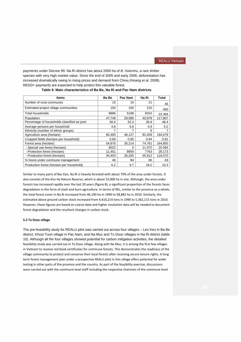
REALU Vietnam
39
payments under Decree 99. Na Ri district has about 2000 ha of B. hsienmu, a rare timber species with very high market value. Since the end of 2005 and early 2006, deforestation has increased dramatically owing to rising prices and demand from China (Hoang et al. 2008). REDD+ payments are expected to help protect this valuable forest.
Table 9. Main characteristics of Ba Be, Na Ri and Pac Nam districts
Items Ba Be Pac Nam Na Ri Total Number of rural communes 15 10 21 46Estimated project village communities 150 100 210 460Total households 9886 5198 8310 23 394Population 47,748 29,080 40,979 117,807Percentage of households classified as poor 56.0 52.3 36.9 48.4Average persons per household 4.8 5.6 4.9 5.0Ethnicity (number of ethnic groups) 7 7 6 7Agriculture area (hectare) 65,493 46,127 82,459 194,079Cropped fields (hectare per household) 0.69 0.85 0.94 0.81Forest area (hectare) 54,876 35,214 74,761 164,850 - Special use forest (hectare) 9022 0 11 072 20 094 - Protection forest (hectare) 11,451 8959 7763 28,173 - Production forest (hectare) 34,403 26,255 55,912 116,570% forest under commune management 46 84 66 63Production forest (hectare per household) 6.2 9.7 18.2 10.3
Similar to many parts of Bac Kan, Na Ri is heavily forested with about 70% of the area under forests. It
also consists of the Kim Hy Nature Reserve, which is about 15,000 ha in size. Although, the area under
forests has increased rapidly over the last 20 years (figure 8), a significant proportion of the forests faces
degradation in the form of slash and burn agriculture. In terms of REL, similar to the province as a whole,
the total forest cover in Na Ri increased from 46,190 ha in 1990 to 58,882 ha in 2010. Similarly, the
estimated above ground carbon stock increased from 4,410,214 tons in 1990 to 5,362,115 tons in 2010.
However, these figures are based on coarse data and higher resolution data will be needed to document
forest degradation and the resultant changes in carbon stock.
5.2 To Dooc village
The pre-feasibility study for REALU pilot was carried out across four villages – Leo Keo in Ba Be district, Khuoi Tuon village in Pac Nam, and Na Muc and To Dooc villages in Na Ri district (table 10). Although all the four villages showed potential for carbon mitigation activities, the detailed feasibility study was carried out in To Dooc village. Along with Na Muc, it is among the first few villages
in Vietnam to receive red book certificates for commune forests. This demonstrates the readiness of the
village community to protect and conserve their local forests after receiving secure tenure rights. A long
term forest management plan under a prospective REALU pilot in this village offers potential for wider
testing in other parts of the province and the country. As part of the feasibility exercise, discussions
were carried out with the commune level staff including the respective chairmen of the commune level

REALU Vietnam
40
peoples’ committees. Focus groups with village representatives, participatory poverty mapping, and
transect surveys helped to understand the layout of the village and potential for REALU activities. This
was followed by estimation of the carbon stock using RaCSA.

REALU Vietnam
41
Table 10. Socio-economic conditions in selected villages of Bac Kan province
LOCATION Leo Keo (Quang Khe, Ba Be) Khuoi Tuon (Nghiem Loan, Pac
Nam) Na Muc (Van Minh, Na Ri) To Dooc (Lang San, Na Ri)
Foundation of the village (Year) 1963 1945 1951 1977
Number of households in 2010 (HH) 45 36 23 29
Main ethnicity in the village ** Tay Red Dzao Tay Nung
Presence of the ethnic group at the commune level (%)
75 46.4 85 32.53
Village poverty rate (including two poorest groups) (%)
78 59 26* 66
Commune poverty (poor HH/total) (%)** 39.36 54.22 57.73 27.50
Electricity Since 2005 Not installed Whole village since 2003 Since 2001 except 5 HH.
Average income of richest group at village (VND/person/month)
>520,000 No cash, subsistence agriculture > 300,000 No cash, subsistence agriculture
Average income of poorest group at village (VND/person/month)
< 400,000 No cash, subsistence agriculture < 20,.000 No cash, subsistence agriculture
Lack of food (months/year) 1-2 3-4 Enough all year round 4-5
Farm size per HH of richest group rice and maize (m2)
>700 m2 2500 and
6000 – 8300 500
3000 and 5000
Farm size per HH of poorest group rice and maize (m2)
<500 1000 and 1600 – 3300
500 2000 and
3000
Forest land allocation All allocated under the
National Park
Cadastral survey conducted in 2007, but allocation hasn’t yet been
implemented
All allocated, including 1 Red Book for Community forest
Partly allocated, including 1 Red Book for commune forest and 3ha production
forest
Data at the village level were collected during the PRA in December 2010 and March 2011, ICRAF Vietnam. Data at the commune level were collected from the districts departments. * The number was not obtained by PRA but by Government’s official number ** According to 30A survey from DOLISA 2010.

REALU Vietnam
42
To Dooc village is part of Lang San commune (annex 8), which also contains a small portion of the Kim Hy Nature Reserve though To Dooc village itself is outside the reserve. The center of the village is located at N 220 14.704’ and E 1060 06.915’. The altitude of the village varies from 274.2m at the main road to 560.1 m at the top of the hill. The village terrain has slopes ranging from 15 to 45 degrees where shifting cultivation is practiced while forestry land is even steeper with an average slope of 30-45 degree. Soils within the village are brown-yellow feralit and the soil layer is 40cm deep with light mechanical composition. There are 29 households in the village, 2/3rd of which are poor. In terms of land use, the maximum area is under forest land (54.72 ha), followed by area under annual crops such as maize and cassava (15.2 ha), and grasslands (10 ha). Rice paddy fields are located at the bottom of the hills in an area of 2.91 ha (table 11).
Table 11. Land use in To Dooc Village, Na Ri District Land Use Area (ha)1. Residential area 12. Rice fields 2.913. Forest land 54.724. Annual crop (maize,
cassava) 15.2
5. Fish pond area 0.466. Grassland 10 Total 84.29
Source: Lang San commune officials 5.3 Forests in To Dooc Forests and forest cover types in To Dooc village include: (1) Secondary forests which were restored after discontinuing with shifting cultivation crops. Main tree species found in these forests include Sau sau (Liquidambar formosana), Thau tau (Aporosa dioica), and Voi thuoc (Schima wallichii). (2) Scrubs mixed with regenerated trees are mainly distributed in open grazing areas with species such as Nuc nac (Oroxylum indicum), Thoi ba (Alangium chinense), and ba dau (Croton eberhardtii). Through plot surveys for different types of land uses and forests in Too Dooc village, floral biodiversity indices were calculated and are presented in table 12. Interestingly individual and commune forests have similar diversity levels.
Table 12: Biodiversity indices of vegetation status in To Dooc village No Types of vegetation/ forest
cover Diversity level/Shannon
(S) Shannon index (H)
1 Scrubs mixed with wood trees 12 2.4308 2 Restorable forests after
shifting cultivation crops (IIa)* 14 2.1327
3 Restorable forests after shifting cultivation crops (IIa)**
14 2.5578

REALU Vietnam
43
* Forests allocated to individual households. **Forest allocated for community management 5.4 Kim Hy Nature Reserve The presence of Kim Hy Nature Reserve close to the To Dooc village presents a potential opportunity to study the impacts of REALU activities on the forest margins. The reserve was established in 2003 and has a total area of 15,416 ha, out of which 14,772 ha is located in the communes of Kim Hy, Luong Thuong, Lang San, An Tinh and Con Minh of Na Ri district; and Cao Son and Vu Muon commune in Bach Thong District. The core zone of the reserve is divided into two protected zones: strict-protected zone (11,505 ha) and the ecological restoration zone (3,267 ha). The buffer zone is 18,921 has, which encompass the entire area of the 7 communes mentioned above. The nature reserve is home to five ethnic groups, namely the Tay, Nung, Dao, Kinh and Hmong ethnic groups. There are 61 villages in seven communes in the conservation area with 2,601 households and 11,283 inhabitants. Of these, 10 villages are located within the nature reserve with 297 households. The strict protected zone on the other hand encompasses 5 villages, with 104 households. The ecological restoration zone includes five villages with 859 households. The vegetation in the north and east of the nature reserve is characterized by a mosaic of swidden fields, secondary vegetation and remnant patches of lowland evergreen forest. This landscape is a result of shifting cultivation. In the south-west of the proposed nature reserve, there is a large area of limestone karst, which is almost entirely forested, except in a few small areas close to habitation (Tordoff et al. 2000). According to the investment plan, Kim Hy proposed nature reserve contains 9,409 ha of natural forest, including 7,104 ha of limestone forest (Pham Xuan Xuong 1997). The results of a rapid field survey in 1999 (Tordoff et al. 2000) indicated that Kim Hy nature reserve may support globally important populations of two primates: Francois's Leaf Monkey Trachypithecus francoisi, and the eastern subspecies of Black-cheeked Crested Gibbon Hylobates concolor nasutus. Subsequent field surveys (F. Momberg and M. Weil verbally 2003) confirmed the presence of Black-cheeked Crested Gibbon but indicated that only a handful of individuals survive. In addition, Kim Hy supports several other species of global or national conservation importance, including Forest Musk Deer Moschus berezovskii, Southern Serow Naemorhedus sumatraensis, and the conifers Keteleeria davidiana, Pseudotsuga brevifolia and Tsuga chinensis var. chinensis (Tordoff et al. 2000). According to the Kim Hy Nature Reserve Management Board, there is currently no infrastructure project that will cause negative effect to the reserve. In the past however, the reserve was strongly affected by gold mining activities in Toc Lu area which were discontinued in 2008 due to their adverse impact to the reserve’s biodiversity and wildlife habitat. 5.5 Carbon stock The RaCSA tool was used to assess/calculate the biomass and carbon stock for different types of land uses in To Dooc village. These included natural poor forests (IIa); scrub mixed with wood trees/open grazing land; upland maize, maize mixed with Xoan/ Agroforestry model and

REALU Vietnam
44
elephant grass. In addition, two plots of natural medium forests were studied in in Quang Phong commune, Na Ri district. These forest areas had similar conditions (geography, soil types and vegetable cover) compared with the forest areas in To Dooc village. Data on the biomass and carbon accumulation are presented in Table 13. For upland maize and maize mixed with xoan/china trees, C-stock of maize was nil because the maize crops were just planted and biomass component was too small. Carbon stock (CS) in biomass was identified through the application of the default 0.46 acknowledged by the Intergovernmental Panel on Climate Change (IPCC, 2003), calculated by the formula:
Wcarbon = 0.46*DW (kg/ha or ton/ha)
Where: Wcacbon – carbon stock; DW – dry biomass. Table 13 shows that: • The amount of above ground carbon accumulated for regenerating forest after shifting
cultivation averaged from 42.59 to 147.66 tonnes C/ha. This type of forest can be classified as re-growth forest, which is consistent with studies in North of Vietnam:
• Vu Tan Phuong (2009) in Yen Bai: according to authors, carbon accumulation in restoration forest and poor forestaverages from 85.71 to 131.89 tonnes C/ha.
• Do Hoang Chung et al (2010): give out the results of forest carbon stocks of natural restoration forest in Dai Tu, Thai Nguyen which varied from 19.08 to 35.27 tonC/ ha.
• The amount of carbon accumulated above ground in case of grass fields (elephant grass
planting) was 1:51 tonC / ha. The result is similar to findings by Do Hoang Chung et al. (2010), which indicates the amount of carbon accumulated on ground grass fields to reach 1.78 tonnes C/ha.
• The results showed that the amount of carbon above ground in case of an agroforestry system consisting of Maize mixed with Xoan (Melia spp) reached 10.7 tonnes C/ha. This is equivalent to the findings of Oliver JZ (2009) on agroforestry systems with perennial crops that had 11.8 tonnes C / ha.
• Studies on the accumulation of carbon below ground in Vietnam is still limited, but in Southeast Asia, Lasco RD (2002) showed accumulation of carbon in soil is from 90 to 780 tons C/ha. Therefore, the results in studies in Na Ri is in a acceptable range (78.05 to 144.52 tonnes C/ha).
• Except for production forests, below ground carbon stock for other land uses in To Dooc was much higher than the above ground carbon stock. This may be due to accumulation of high levels of organic material in the soil. However, more data needs to be collected to corroborate these results.

REALU Vietnam
45
Table 13. Biomass and C-stock of the surveyed land uses
No. Land use type Biomass (t/ha) C-stock (t/ha) Note
Aboveground Belowground Aboveground Belowground1 Elephant grass (planted) 3.29 289.42 1.51 133.13 To Dooc Village 2 Upland maize - 234.87 - 108.04 As above 3 Upland maize + Xoan 23.26 234.87 10.70 108.04 As above 4 Shrub with scattered tree 131.81 189.10 60.63 86.99 As above 5 Regenerate forest (following
shifting cultivation) – IIa * 192.17 261.7 88.40 120.39 As above
6 Regenerate forest (following shifting cultivation) – IIa ** 92.59 314.17 42.59 144.52
As above
7 Medium production forest (after timber exploitation)* 283.92 213.23
130.60
98.08
Quang Phong Commune
8 Medium production forest (after timber exploitation)** 321.00 169.68 147.66 78.05
Quang Phong Commune
* Forests allocated to individual households. **Forest allocated for community management

REALU Vietnam
46
5.6 Drivers of deforestation and forest degradation Interviews with commune officers and group household meetings revealed that the land use change was a result of deforestation and forest degradation that has been going on since the 1970s. Specifically: • In 1960s, most of forest area in To Dooc village consisted of primary forests (Phien Det
forest area in To Dooc village). Main species included sau sau (Liquidambar formosana) and Xoan (Melia spp, diameter: 1.5 m, height : 20 - 30m); and other Non-Timber Forest Product (NTFPs) like rattans, bastard cardamom and other traditional medicine species. There were also many wildlife species reported such as deer, serow, wild pig, tortoise, pangolin and primates etc.
• Since the 1970s, forests have changed a lot due to shifting cultivation, logging (legal and illegal) for trade as well as building houses for the local communities, forest fire, hunting and forest plantation under the 661 program or the 5 million-hectare forest program wherein large patches of poor or restorable forests were converted to plantation forest.
• In recent years, the commune forests have been brought under enrichment and better
protection especially after the support received from the CARD project which helped the village in getting red book certificate for its commune forest. However, further enrichment through replantation on the forest margins, and more protection measures will be needed including support to negotiate norms for using the commune forest with the neighboring villages.
• Other threats to carbon stocks are in the form of timber logging for house repair activities,
house building as well as firewood collection. On the average, each house needs about 5 – 6 cubic meters of Xoan timber (average price for Xoan timber is VND 1.5 million/m3) and 2m3 of Sau sau timber (from VND 0.7 to 0.8 million/ m3). In terms of firewood, on average, each household utilizes 20kg of firewood which costs about VND 50,000.
5.7 Emission reduction activities under REALU The above analysis shows that the main drivers of deforestation/degradation as well as loss of carbon are mono-cropping of upland maize, open grazing, and need for firewood and timber for subsistence purposes. Accordingly, three main land use changes have been identified under the proposed REALU plan that would help in emission reduction: • Conversion of open grazing into well fenced grasslands from which local households can cut and
carry fodder. This will help increase the carbon stock from zero to an average of 1.51 tons of
carbon/ha (tC/ha) above ground. This activity will also help address the fodder need in the area by
improving the productivity of the grasslands.

REALU Vietnam
47
• Converting private upland maize fields to agroforestry where maize will be intercropped with Xoan
trees (Melia spp.) helping to increase the carbon stock from zero to 10.70 tC/ha above ground. This
activity will address an important driver of deforestation – the need for firewood which cannot be
met only from the private production forests and so local people cut down trees in the commune
forests. It will stabilize mountain slopes and the resultant carbon revenue will provide an additional
source of income.
• Enhanced protection, restocking and management of commune forests helping to increase the
carbon stock from 60.63 tC/ha to 88.40 tC/ha (above ground). Although the commune forest in the
village is better protected than in many other local villages, illegal felling and intrusion from
neighboring villages results in sub‐optimal carbon stock. A more comprehensive management plan
that includes scope for restocking commune forests through regeneration and replantation, as well
as negotiation with neighboring villages on building norms around forest use will help sustain the
carbon stock in the long run.
During a stakeholder consultation in Bac Kan province in June 2011, community representatives
expressed willingness to participate in these REALU activities. ICRAF is now carrying out a more detailed
investigation in the area to prepare a specific plan of REALU activities that will be implemented by the
3PAD project. An important focus of this plan is to come up with a fair and effective benefit distribution
system that includes the use of the community development fund of VND 30 million available for the
village. As part of the institutional arrangements, 3PAD officers will directly work with the village level
management board inTo Dooc with the involvement of commune level staff wherever necessary.
5.8 Participatory Carbon Monitoring
Since the scale of operations in To Dooc village will be too small to monitor through remote sensing
alone, ICRAF is working on a participatory carbon monitoring (PCM) system. Under this system, a
training manual is being written that lays down principles and objectives behind participatory carbon
monitoring as well as detailed steps on how community members can carry out simple biomass surveys
in the field to monitor the changes due to REALU activities. ICRAF scientists will use this manual to train
representatives of the 3PAD staff as well as members of the village management boards in how to carry
out carbon surveys in the field. This PCM will also be integrated with the province level remote sensing
based MRV system that ICRAF will develop in collaboration with the Michigan State University. Results
and experience from field level pilot activities will be shared at the province and the national level to
backstop REDD+ activities in Vietnam. Several related research activities will also be carried out which
include an in‐depth review of the relationship between land tenure process and REDD+ design in
Vietnam, socio‐economic impact assessment of carbon payments under REDD+/REALU, estimating
opportunity costs of forest management in different parts of the country, and developing fair and
effective benefit distribution system.

REALU Vietnam
48
6. Co‐benefits and Monitoring, Reporting and Verification
A stated benefit of the REDD+/REALU process both at the international and national level is to promote
sustainable development among local communities. Policy makers look at carbon mitigation activities as
a way to improve land use planning and management in a way that it also helps improve economic well‐
being as well as sustains all around improvement in environmental indicators such as forest health, soil
productivity, and biodiversity. The proposed REALU activities in Bac Kan will potentially create several
important co‐benefits at the provincial level as well as in To Dooc village where the field pilot is being
planned.
At the provincial level, an important outcome of the REALU activities would be a move towards cross‐
sectoral land use planning. The national and the provincial government already do prepare five year land
use plans. However, these plans do not address drivers of deforestation or carbon emissions. Instead,
landscape level planning that accounts for changes in carbon flux among all carbon rich land uses, will
help improve the long term productivity of land resources. These plans will also help promote a more
sustainable management of various kinds of forests and other productive resources, in turn securing
additional environmental services such as hydrological regulation, scenic beauty, and biodiversity.
In terms of economic benefits, the direct contribution of REDD+/REALU payments to the household
income will be small unless there is a sudden increase in the carbon price prevalent in international
markets. A possible way to improve the payment level is to bundle payments for different
environmental services into one. ICRAF will further test the feasibility of these bundled payments
through a pilot PES program in the Ba Be National Park where the local households are likely to receive
the hydrological payments under PFES, which can potentially be combined with payments for
ecotourism as well as for REDD+ activities. Even then, these payments are unlikely to move people out
of poverty, though they can ensure that local households have access to regular cash income, which can
then be invested in other productive activities such as purchase of improved agricultural seeds or
investment in farm improvement. However, the indirect benefits of REDD+/REALU activities are
expected to be large and substantial. Improved forest and agricultural resources means that farmers are
not only able to meet their subsistence needs of food, fodder, and firewood, they also have additional
outputs to sell in the market. REDD+/REALU process may also help strengthen the institutional
arrangements, especially in terms of relations between government officials and local people, and in
terms of more capable and robust village level institutions such as forest management boards.
These co‐benefits, especially at the village level, can be tracked through socio‐economic surveys and
other participatory exercises. Any such exercise will however, need to identify the level of impact – i.e. (i) plot level, (ii) household level, and (iii) village or community level. The level will also depend on the activity. For instance, farm based agroforestry activities that result in payments to individual households will require an estimation of changes in household incomes due to the project. In addition, one can look at community wide impacts such as changes in infrastructure,

REALU Vietnam
49
access to better health or educational facilities etc. If the plots on which these forestry activities are implemented, are randomly chosen, the study can also use GIS and remote sensing data to measure plot level impacts in terms of the change in biomass and its market value, diversity in cropping patterns, or any other relevant measures of local resilience to environmental shocks. This would be done by preparing a pre-project baseline that can then be compared to the post-project scenario on each of the indicators. Following is the preliminary list of indicators based on the sustainable rural livelihoods framework, which will be adapted according to the local context in Bac Kan province (Table 14).
Table 14: Five kinds of capitals and indicators to measure them
Types of capital IndicatorsFinancial capital - gross household income
- diversity in sources of income - access to permanent job - access to wage labour - cultivation of commercial crops - livestock ownership - ownership of consumer durables
Human capital - gender division of labour - average literacy rate - investments in training and capacity building - awareness on improved agricultural practices
Natural capital - land tenure and property rights - permanence of agroforestry contracts - perceived benefits from agroforestry practices - status of food security (food purchased from outside)
Social capital - status of local leadership (community association) - management of community trust fund - level of women’s participation in the project
Physical capital - status of education/health infrastructure - access to market
6.1 Monitoring, Reporting, and Verification Monitoring (and measurement), reporting, and verification (MRV) are necessary components of a REDD+/REALU program since they assist policy makers, investors, and service providers to know about the impact of conservation practices on carbon stocks in an area. Unlike conventional development projects where monitoring and impact assessment often took place at the end of the project period, REDD+ processes require a periodic check on the effectiveness of conservation activities in reducing land use related emissions. Changes in carbon stock (or carbon fluxes) are measured against a historical baseline. Once a baseline period is decided

REALU Vietnam
50
(which is more of a policy decision), changes in carbon stocks over this period constitute the reference emission level (REL) against which all future emission reductions are measured to estimate the impact of REDD+ activities. An important requirement of an MRV system is that it provides accurate data at a reasonable cost. That means that it can not only measure changes in carbon stocks within the project area, but also detect leakage due to changes outside the project areas. In case of REALU, a strong requirement is that the MRV system be able to capture changes in carbon stocks not just in the forest areas but also across other carbon rich parts of the landscape. Another important requirement for policy makers is that an MRV system provides a reliable estimate of changes in socio-economic status in an area, especially if the goal of a REDD+ project is to promote sustainable development in the area. This means that a top-down approach based solely on remote sensing images is unlikely to succeed. Instead, a combination of remote sensing based analysis and field based participatory carbon monitoring (PCM) would be needed to collect and corroborate diverse sets of data that can provide a more complete picture of the changes that are happening within project areas. ICRAF proposes to follow this approach by collaborating with scientists from Michigan State University (MSU) to develop and field test an MRV system in Bac Kan province that is based on a combination of high resolution remote sensing imagery at the province level with field based PCM measures, starting in To Dooc village. MSU’s Global Observatory for Ecosystem Services is a leading scientific group that conducts research on developing cost effective MRV systems in developing countries. Using high resolution remote sensing images, the team will estimate a more precise reference emission level (REL) for Bac Kan that takes into account forest degradation and emissions from other carbon rich land uses that are outside the forest areas. The REL will help address concerns regarding whether or not the province has actually added carbon stocks over the last 20 years and will aid policy makers in defining an appropriate baseline period. The team will use Geographical Information Systems modeling to estimate carbon stocks under alternate emission reduction scenarios as compared to business as usual. Along with this exercise at the province level, the MSU-ICRAF team will also conduct participatory carbon monitoring of changes in carbon stocks in the proposed REALU pilot area of To Dooc village. ICRAF has already developed tools for carbon assessment such as PALA (participatory landscape analysis) and RaCSA (rapid carbon stock assessment) that will be used in preparing a manual that can be used to train village representatives, commune level staff, as well as local forestry staff in carrying out carbon surveys in the project area. Data gathered through the PCM based carbon surveys in the project area in To Dooc village will be integrated with the MRV results at the province level to prepare more precise estimates of changes in carbon stocks in different parts of the province. The results and experience of this integrated MRV system will be shared through a national level workshop in Hanoi as well as through research reports and papers.

REALU Vietnam
51
7. Conclusion
This document presents the feasibility analysis for undertaking REALU activities at the sub‐national level
in Vietnam in a way to complement the ongoing REDD+ programs and to add momentum to current
initiatives on carbon mitigation through sustainable land use. Apart from the national level backstopping
of the UN‐REDD program, ICRAF proposes to take up more action research oriented activities in Bac Kan
province, one of the candidates for the expansion of the UN‐REDD program. Bac Kan presents an
interesting case where the area under forests has consistently increased in the last 20 years and hence
the conventional way of estimating reference emission level may not work. While ICRAF suggests the
use of alternative landscape level REL, more precise data may also be needed to capture loss of forest
quality due to degradation and emissions outside the forest areas.
Under the proposed plan, ICRAF will facilitate in the design and implementation of REDD+ program at
the province level and share experience from its own field activities in different parts of the country.
Training workshops and stakeholder consultations will be organized to share knowledge on carbon
management tools such as Rapid carbon stock appraisal tool, MRV approaches, and cross‐sectoral
planning necessary to capture emissions at the landscape level. ICRAF will also assist in developing a fair
and effective benefit distribution system that incorporates key guidelines from the current discussions
at the national and international level, such as free and informed prior consent, flexibility in payment
systems, and alternatives to reduce transaction costs.
ICRAF has an‐going collaboration with the Department of Agriculture and Rural Development and a
memorandum of understanding with 3PAD project to provide technical assistance on design of PES
pilots including carbon management activities through sustainable land use. As part of this, ICRAF will
help 3PAD in design of pilot REDD+/REALU program in To Dooc village of Na Ri district, which is one of
the few villages to receive red book certificate for managing its commune forests. Consultations with
community representatives and field surveys/PRA exercises indicate ample scope for promoting high
carbon pathways, such as changing land use from mono‐cropped maize on sloping lands to agroforestry,
from open grazing lands to cultivation of stylo grass, and further enrichment and protection of the
commune forests. ICRAF will also design mechanism for the efficient use of the community development
fund that the 3PAD project will transfer to the village community. In the next few months, more field
surveys and group exercises will be carried out to prepare a work plan as well as to test the feasibility of
undertaking participatory carbon monitoring in the village. Under MRV, ICRAF also proposes to
collaborate with the Michigan State University to develop a more precise estimate of the reference
emission level and the potential emission reduction scenarios using high resolution remote sensing
images.

REALU Vietnam
52
7.1 Major opportunities The feasibility exercise for REALU activities at the sub-national level in Bac Kan province highlights several important opportunities: • Willingness of the provincial government agencies to collaborate with ICRAF will help in
increasing awareness on the advantages of integrating landscape approach promoted under REALU with the REDD+ activities that are due to follow as part of the UN-REDD program in the country.
• The ongoing technical collaboration between ICRAF and IFAD’s 3PAD project will not only help in pilot testing REALU activities in the field, but will also create opportunity for their wider replication in other 3PAD areas.
• Similarly, the field experience in To Dooc village will not only help in Documenting the potential of REALU in promoting sustainable land use, but also in identifying major constraints in addressing drivers of deforestation. The pilot REALU program will also test the feasibility of participatory carbon monitoring in increasing the community’s stake in carbon management activities as well as the potential for generating reliable data on changes in carbon stocks.
• Existence of Kim Hy reserve adjacent to REALU pilot sites as well as Ba Be National park in Ba Be district will help test the potential for scaling up forest management activities in special use forests, both within Bac Kan province and in other parts of the country. This assumes significance under Decision 99 whereby forest managers could receive payments for providing valuable environmental services. In many areas, however, water and ecotourism payments will be quite low, but could be bundled with the carbon payments under the REDD+ program thus creating a more holistic and sustainable PES program.
• ICRAF’s collaboration with PPC, DARD, IFAD, and other government agencies offers opportunity to backstop government’s REDD+ program and to facilitate in formulating policies that assist in cross-sectoral planning.
• ICRAF’s existing capacity on REDD+: RESFA (REDD+/REALU Site Feasibility Assessment), RaCSA (Rapid Carbon Stock Appraisal), and PES experiences and studies in conjunction with RUPES project.
7.2 Challenges One of the main challenges in promoting REDD/REALU among local communities is the creation of fair and effective benefit distribution system (BDS) that incentivizes forest managers for investing in conservation. Such a system will need to balance between community’s need for immediate benefits with the program objective of offering conditional, performance based payments. BDS is one of the focal areas for the on-going research under UN-REDD program in Vietnam and will be a core challenge to address under REALU activities in Bac Kan province. A related challenge is of tenure security and rights to carbon stock. Under the 2003 Land Law and the 2004 Forest Protection and Development Law, forestland has been allocated to households and village communities through red book certificates. However, a vast proportion of the

REALU Vietnam
53
population still has insecure land tenure which will limit their claims to carbon payments under a REDD+ regime. Addressing this challenge will be important for ensuring that REDD and REALU activities are beneficial for everyone. A possible alternative is to provide carbon rights even if the land rights are unclear. This is a policy question which is currently being debated at the national level and the pilot REALU activities in Bac Kan may provide useful insights on the question of land and carbon rights for the local communities. REALU promotes a landscape level approach. Although many resource management initiatives such as watershed management have associated physical units such as a micro-watershed, defining a specific landscape unit for carbon activities is difficult. This has implications for both planning carbon management activities as well as for devising sub-national level MRV system since it is difficult to define a clear cut boundary that differentiates project areas from non-project areas. For the present, the REALU pilot will focus on three main carbon rich land uses in selected villages in Na Ri district of Bac Kan province. However, this may be insufficient when government agencies decide to replicate carbon management on a wider scale. Defining a viable unit of landscape for planning and implementation will therefore be an important challenge for REALU. In specific case of Bac Kan province where forest area has actually increased over the past 20 years, the conventional system of estimating the reference emission level may no longer be appropriate. In addition, even the business as usual scenario will be inadequate since it penalizes communities and governments for conservation action already taken. Although the REALU approach that takes into account carbon dynamics on all land uses helps in creating incentives for carbon management outside the forest areas, it does not help solve the question on REL. Instead, wider policy level discussions are needed for areas that have actually gained carbon stock in the recent past, but remain susceptible to its loss due to socio-economic pressures. 7.3 Constraints A major constraint in promoting carbon rich land uses is the dichotomy between valuing environmental services and yet not being able to compensate the opportunity cost of conservation. REDD/REALU and its precursor Clean Development Mechanism (CDM) were based on creating sustainable development benefits for tropical countries by monetizing carbon stored in local forests. However, due to global geopolitics, the price of carbon in international markets, especially of forest carbon in voluntary markets remains subdued and cannot adequately compensate the opportunity cost of establishing long term carbon contracts. At the project level, availability of capable staff that can carry out REALU related activities and research, remains an important constraint. ICRAF is trying to address this concern by recruiting international staff, as well as through regular trainings and workshops for its in-house staff as

REALU Vietnam
54
well as for staff members of other government and NGO agencies that are involved in REDD+ activities.
Annex 1. Current REDD/REDD+ activities in Vietnam • Most of the activities are located in Northern, Central and Highland plateau. • ICRAF and its partners (MARD, MONRE, SFM, GDLA, and provinces ) are working on
cross-sectoral causes of deforestation and degradation, carbon price, emission reduction methods, including sustainable forest and land use options (SFM, AF, participatory LUP).
• JICA , SNV and UN-REDD mainly focus their activities on the development of technical aspects of REDD with the clearly forestry focus, such as REL, carbon measurement methods, and using remote sensing for mapping potential REDD areas in Vietnam.
1. ICRAF: RACSA 2. ICRAF: Community BDS in Ba Be district 3. ICRAF: participatory LUP in Ba Be district 4. ICRAF: suggestion of a Carbon fund
1. UN-REDD: Survey on impact of PFES on water 2. SNV: BDS to community in Cat Tien National
Park 3. SNV (contract to Winrock Int.): community C
monitoring 4. JICA and SNV: RS for forest coverage
classification 5. SNV: Participatory LUP in Cat Tien National Park 6. SNV: drivers for D and D 7. UN-REDD: suggestion of a Carbon fund
1. JICA and SNV: RS for forest coverage classification
1. JICA and SNV: RS for forest coverage classification
1. GTZ and AUSAID: Conservation and Development of the Biosphere Reserve of Kien Giang Province: RS for mangrove forest mapping, C credit baseline and feasibility of community SFM
1. ICRAF: C price for LUC by OPCOST model
2. GDLA/ (MONRE)/ICRAF: review of cross-sectoral LUP
3. ICRAF: Satellite, remote sensing, and participatory methods for mapping LUC and drivers of deforestation °radation

REALU Vietnam
55
Annex 2. Definition of forest in Vietnam According to Vietnam’s Forest Protection and Development Law 2004, “forest” is defined as ‘an ecosystem with trees, animals and biota, soil and other environmental factors, in which timber species, bamboo or other species provide a canopy cover of more than 10%. Plantation forest and natural forest are grouped into production forest, protection forest and special-use forest. In 2009, MARD introduced the most recently updated definition for Vietnam2, where an area will be identified as a forest if it meets all the following 3 criteria: (i) being an ecosystem in which the main components are perennial timber species, coconut and other species with trees taller than 5m and a canopy cover of more than 10% (except newly established forest plantations and some mangrove forest), that can provide timber, NTFPs and other direct and indirect environmental services, such as biodiversity conservation, environmental protection and landscape beauty'. New forest plantations of timber trees and newly regenerated forests after exploitation of forest plantations will be identified as forests if they reach the average height of over 1.5 meters for slow-growing trees (for example, pine trees and some indigenous trees) and over 3 meters for fast-growing trees (such as wattle and eucalyptus) and a density of at least 1,000 trees per hectare; (ii) having a canopy cover of at least 0.1 for trees which constitute its major component; and (iii) having forest plots of at least 0.5 hectare each or forest tree strips of at least 20 meters in width and be composed of at least 3 tree lines. Thus, the term 'forest', as now defined for Vietnam is very close to that of the FAO and the UNFCCC.

REALU Vietnam
56
Annex 3. Area, yield and production of major crops in Bac Kan Province
Units: area (ha), yield (quintal/ha), production (tons)
Crops 2006 2007 2008 2009
Paddy Rice
Area 20778 21235 21272 21822
Yield 42.4 43.77 43.44 44.07
Production 88091 92939 92413 96167
Maize
Area 14235 16133 16708 16036
Yield 24.77 34.47 35.1 34.73
Production 35253 55605 58638 55689
Soybean
Area 2316 2126 2349 2433
Yield 12.36 13.1 15.06 16.67
Production 2862 2785 3538 4056
Perennial industrial crops
Area 8497 8634 8991 8388
Gathering area 2774 2671 2802 3000
Production 6839 5880 6399 5963
Fruit crops
Area 3959 3743 3873 3574
Gathering area 2375 2350 2616 2487
Production 8500 8909 10895 12638 (Source: Bac Kan Statistical Yearbook)
Annex 4. Forest plantation projects carried out in Bac Kan from 1990 to 2010
Name of project/program Implementation period
PAM 5322 Project 1997‐2002
327 Project 1997‐1998
661 Program 1999 onwards
Vietnam‐Finland Afforestation Project 1997‐2003
CBBC Rural Development Project 2001‐2005
Resettlement Project 1997‐2010
Project 30A 2008
Project 147 2010 onwards
Materials Forest Plantation Project 2002‐2004
Provincial Forestry Project 2001‐2004
(Source: Bac Can Forestry Development Department)

REALU Vietnam
57
Annex 5. Procedure for estimating forest volume and carbon stock in Bac Kan
Forest volume Total forest volume is given as:
Total volume (m3) = Total area (ha)* state’s average volume (m3) In which the state’s average volume is identified based on primary blocks included in the forest evolvement monitoring program, cycle IV - FIPI.
TableA5: State’s average volume (in m3)
State Average volume /haEvergreen broadleaves forest – Rich 260Evergreen broadleaves forest – Medium 154Evergreen broadleaves forest – Poor 87Evergreen broadleaves forest – Regrowth 54Mixed Wood-Bamboo 45Limestone Forest 85Plantation forest 45
Source: FIPI
Carbon stock The total carbon stock is given based on the calculation of average forest stock for each forest state. It is given by available equations providing by IPCC, including: • Above-ground biomass The total biomass for timber from the total standing tree volume is given by the equotion:
AGB (t/ha) = VOB * WD * BEF , in which: AGB = Above-ground biomass for timber trees VOB = Trunk volume m3
WD = wood density BEF = Exp(3.213-0.506*Ln(biomass)) • Fresh underground biomass The total fresh biomass for below-derground timer is given by
BGB = AGB * 0.265 (Standard value for tropical forest – IPCC 2006), in which: AGB = Above-ground biomass BGB = Below-ground biomass
• Dead biomass

REALU Vietnam
58
The dead biomass is given by: DB = (AGB+BGB) * 0.11
(Standard value for tropical forest – IPCC 2006), in which: DB = Dead biomass AGB = Above-ground biomass BGB = Below-ground biomass
• The total forest biomass The total forest biomass is given by:
TB = AGB+BGB+ DB, In which: TB= Forest total biomass AGB = Above-ground biomass BGB = Below-ground biomass DB = Dead biomass
• Total carbon stock Carbon stock is given by 0.5*TB.

REALU Vietnam
59
Annex 6. Unsustainable land use practices in Bac Kan: Results from PRA exercises carried out by ICRAF
In order to Document current land use practices in Bac Kan, ICRAF scientists undertook PRA exercises in different parts of the province. The study found that even though local people were heavily dependent on forest resources, some of the current practices were unsustainable, as they would potentially degrade forest and forest land in the long run. These were slash and burn agriculture, illegal logging, agriculture on slopping land and forest land, mono-cropping of maize, and cattle grazing (see the following table).
Table A6. Unsustainable land use practices in Bac Kan Unsustainable practices Study villages Leo Keo
(Ba Be district)
Khuoi Tuan (Pac Nam
district)
To Dooc (Na Ri district)
Na Muc (Na Ri district)
Slash and burn agriculture
x
Illegal logging X Agriculture on steep slopes
X x x x
Agriculture on forest land X x x x Mono cropping of maize x x x Free grazing X x x x (Source: ICRAF)
Shifting cultivation/agriculture on forest land Fields of upland crops on forest land were found in all the villages, with some of the fields dating back to the 1950’s (Khuoi Tuon village). Most of these fields had maize as a mono-crop or predominant crop. All these fields had their origin in slash and burn practices on forest land at different times with some of the fields still been subject to these practices (e.g. Khuoi Tuon village). Many of the fields had been completely cleared of trees after years of cultivation, but they were still located in or close to forest land. Some of the fields had been already mapped by the responsible cadastral unit and allocated with the red book certificates. In areas where the land allocation has not yet been implemented customary rights seem to keep some control of the expansion of the land, together with the efforts of the responsible forest protection division, although some risk of fire extension is still present (e.g. khuoi Tuon). Some of fields had been created even before village foundation (To Dooc) by farmers coming from neighboring areas, while others appeared together with the settlement of new households (Na Muc, Khuoi Tuon, Leo Keo). Most of these plots started either before or during the cooperative time, period in which shifting cultivation was intensified due to lack of individual responsibilities and unclear land tenure rights. In some cases the constant exploitation of the land led to a change from forest land to grass land, being later on turned again into upland crops (Khuoi Tuon). Field observations show that shifting cultivation was rarely used as a direct source of livelihood but

REALU Vietnam
60
rather as a way to secure family nutrition or for fattening cattle with maize and cassava. Even in the cases where these crops were used to generate cash income, the poverty rates did not seem to be heavily influenced (richest group in Na Muc village stands slightly above 300,000 VND/person/month) Agriculture on steep slopes Another common practice that was quite prevalent was the existence of agriculture on land with slopes ranging from above 300 (Leo Keo) to 600 (To Dooc). In some cases the sloping land was nearby the current forest or the hill tops (Leo Keo, Na Muc), but sometimes they were located halfway to the top (Khuoi Tuon). An increase in population and the resultant scarcity of agricultural land seems to push farmers from the lowland on river banks to uphill lands, in order to grow enough food for subsistence. However, farmers were aware of the environmental problems that these practices could cause (changes in downstream water flow, e.g. in Leo Keo), while many others had adopted terracing, contour cultivation, grass plantation, or tree planting to control soil erosion from steep slopes (Khuoi Tuon). Free cattle grazing Cattle is a key element both as a source of food, as an income generating practice, or in carrying out agricultural practices. Cattle ownership seemed to increase with the economic status of the households, with many households using cattle to escape poverty. Even though cattle feed consisted of a mix of wild grasses and cultivated crops such as maize and cassava, and residues from paddy rice and vegetables, free grazing was often observed on non allocated lands or on community lands resulting in land degradation. Several projects have been initiated that promote fodder cultivation (stylo grass, elephant grass) instead of free grazing. However many of them failed because they were either not self sustaining or because of climatic conditions (Khuoi Tuon). Illegal logging Illegal logging might be subject to discussion as regulations evolve. This practice was only tracked in Leo Keo village, located in the core zone of Ba Be National Park, where farmers have traditionally used wood for house construction. Although PRA looked at only the current logging practices, secondary data at the district level indicated cases of “Nghien” trees (Burreitiodendrom hsienmu) being cut down in the past. Conclusion Farmers did seem to be aware of land degradation issues due to unsustainable practices but poverty, lack of income, and food insecurity related to infertile land or scarcity of productive land - and in some cases unclear land tenure (common fields) - seemed to push them into unsustainable practices.

REALU Vietnam
61

REALU Vietnam
62
Annex 7. Ministry of Agriculture and Rural Development (MARD) land classification system
FOREST
Rich timber forest
Medium timber forest
Poor timber forest
Recovered timber forest
Bamboo forest
Mixed forest
Forest on rocky mountain
Planted forest
MOSAIC Shiifting cultivation
NON-FOREST VEGETATION
Rocky mountain without forest
Bareland with grass and shrub
Bareland with scattered trees
Agriculture
Industrial perennial crop
Mixed fruit garden
Annual crop-rice
Annual mixed crops
Non-vegetated
Settlement
Specially used land
Water surface

REALU Vietnam
63
Annex 8. Maps of Lang San commune

REALU Vietnam
64
Village sketch: To Dooc Village

REALU Vietnam
65
Photographs
Village Red Book, page 2&3 Village Red Book, page 1 & 4
Group meeting with village representatives Na Muc Village leader
Local landscape Na Muc community forest
Rice paddy fields Collection of firewood in To Dooc