Product Specification...
29
©ARGANS Ltd (2019) Sea Surface Salinity Climate Change Initiative Phase 1 Product Specification Document Product Specification Document (PSD) Customer: ESA Ref.: ESA-CCI-PRGM-EOPS-SW-17-0032 Version: v1r6 Ref. internal: ARG-003-039 Revision Date: 24/04/2019 Filename: SSS_cci-D1.2-PSD-v1r6.docx
Transcript of Product Specification...

©ARGANS Ltd (2019)
Sea Surface Salinity Climate Change Initiative Phase 1
Product Specification Document
Product Specification Document (PSD)
Customer: ESA Ref.: ESA-CCI-PRGM-EOPS-SW-17-0032
Version: v1r6
Ref. internal: ARG-003-039 Revision Date: 24/04/2019
Filename: SSS_cci-D1.2-PSD-v1r6.docx

Sea Surface Salinity Climate Change Initiative Phase 1 (ESA CCI Phase 3)
Product Specification Document
Ref: ESA-CCI-PRGM-EOPS-SW-17-0032 Date: 24/05/2019
Page: ii
©ARGANS Ltd (2019) Filename: SSS_cci-D1.2-PSD-v1r6.docx
AUTHOR Julia Köhler
27/05/2019
REVIEWED BY Detlef Stammer
27/05/2019
REVIEWED BY Frederic Rouffi
REVIEWED BY Jacqueline Boutin (Science Leader)
16/05/2019
REVIEWED BY Nicolas Reul (Science Leader)
16/05/2019
AUTHORISED BY Rafael Catany (Project Manager)
16/05/2019
ACCEPTED BY Craig Donlon (Technical Officer)
DIFFUSION LIST Sea Surface Salinity Team Members
ESA (Craig Donlon, Paolo Cipollini)
DOCUMENT CHANGE RECORD
DATE / ISSUE DESCRIPTION SECTION /
PAGE
01/02/19 v1r4
Initial version sent to ESA for review
23/04/19 v1r5
Revision following ESA comments
24/04/19 v1r6 (this issue)
Updated product file naming 2.2

Sea Surface Salinity Climate Change Initiative Phase 1 (ESA CCI Phase 3)
Product Specification Document
Ref: ESA-CCI-PRGM-EOPS-SW-17-0032 Date: 24/05/2019
Page: iii
©ARGANS Ltd (2019) Filename: SSS_cci-D1.2-PSD-v1r6.docx
Blank Page

Sea Surface Salinity Climate Change Initiative Phase 1 (ESA CCI Phase 3)
Product Specification Document
Ref: ESA-CCI-PRGM-EOPS-SW-17-0032 Date: 24/05/2019
Page: iv
©ARGANS Ltd (2019) Filename: SSS_cci-D1.2-PSD-v1r6.docx
Table of Contents 1 Introduction ...................................................................................................................1
1.1 Purpose and Scope ............................................................................................................. 1
1.2 Recommendations for Product Specification ....................................................................... 1
1.3 References ......................................................................................................................... 2 1.3.1 Applicable Documents ........................................................................................................................... 2 1.3.2 Reference Documents ........................................................................................................................... 2
1.4 Acronyms ........................................................................................................................... 2
2 Product format and metadata ........................................................................................4
2.1 Data format ....................................................................................................................... 4
2.2 Filename convention .......................................................................................................... 4 2.2.1 CCI Project ............................................................................................................................................. 5 2.2.2 Processing level ..................................................................................................................................... 5 2.2.3 Data Type ............................................................................................................................................... 6 2.2.4 Product String ........................................................................................................................................ 6 2.2.5 Additional Segregator ............................................................................................................................ 6
2.3 Data access ........................................................................................................................ 6
2.4 Attributes........................................................................................................................... 7 2.4.1 Global attributes .................................................................................................................................... 7 2.4.2 Variable attributes ...............................................................................................................................10
3 Spatial and temporal resolution, grid format and projection ......................................... 20
3.1 Spatial resolution ............................................................................................................. 20
3.2 Temporal resolution ......................................................................................................... 20
3.3 Grid format, map projection and coverage ........................................................................ 20
4 Error budget and uncertainties ..................................................................................... 21
4.1 Characterizing error and error budgeting .......................................................................... 21
4.2 Data format for uncertainty information ........................................................................... 21
5 Quality indicators and flags.......................................................................................... 22
5.1 Quality indicators ............................................................................................................. 22
5.2 Flags ................................................................................................................................ 22
6 Summary ..................................................................................................................... 23

Sea Surface Salinity Climate Change Initiative Phase 1 (ESA CCI Phase 3)
Product Specification Document
Ref: ESA-CCI-PRGM-EOPS-SW-17-0032 Date: 24/05/2019
Page: 1 of 25
©ARGANS Ltd (2019) Filename: SSS_cci-D1.2-PSD-v1r6.docx
1 Introduction 1
1.1 Purpose and Scope 2
The purpose of this document is to convert the user requirements, summarized in the User 3
Requirement Document (URD, [AD01]), into a detailed set of Sea Surface Salinity (SSS) product 4
specifications of the Seasurface Surface Salinity Climate Change Initiative (CCI+SSS) project. 5
The PSD provides results from a detailed analysis of the requirements of current and future 6
users of satellite SSS. The survey aims to involve users in the development process of the 7
CCI+SSS product and to understand their needs prior to the start of the product development. 8
The PSD connects the recommendations from the URD with the aim to produce a detailed set 9
of product specifications that respond to the user needs and are continuously assessed 10
against their needs. 11
12
1.2 Recommendations for Product Specification 13
The survey conducted by the project was very detailed and the requirements are widely 14
spread. Therefore, not all aspects of user requirements are covered by the first phase of 15
CCI+SSS. (which coincides with the third programmatic phase of the whole CCI Program). 16
The goal is to design products that meet as many requirements as possible taking into account 17
the available options. The recommendations derived here from the user consultation relate 18
to the need for a growing and diverse user community and their needs: 19
1) make high-resolution data available, to account for the high diversity of requirements 20
for spatio-temporal resolution of the products. The survey results show, that the 21
resolution needs strongly depend on the analyzed phenomena ranging from original 22
spatial sampling to 10° and temporal resolution from weekly (daily sampling) to 23
monthly (15 day sampling). 24
2) Error specification for L4 SSS product, along with error estimation details, to account 25
for the need of broad uncertainty specification. The CCI+SSS product will contain the 26
random error, systematic error, standard deviation of the bias, as well as good/bad 27
flags computed from different indicators (Xi2, number of outliers). 28
3) Compatibility between products (L2,L3,L4, other CCI products) 29

Sea Surface Salinity Climate Change Initiative Phase 1 (ESA CCI Phase 3)
Product Specification Document
Ref: ESA-CCI-PRGM-EOPS-SW-17-0032 Date: 24/05/2019
Page: 2 of 25
©ARGANS Ltd (2019) Filename: SSS_cci-D1.2-PSD-v1r6.docx
1.3 References 30
1.3.1 Applicable Documents 31
ID DOCUMENT REFERENCE
AD01 User Reference Document (URD) SSS_cci_D1.1_URD-i1r4
1.3.2 Reference Documents 32
List here all the document that must be read in the conjunction of this document. 33
ID DOCUMENT REFERENCE
RD01 End-to-End ECV Uncertainty Budget E3UB
RD02 CCI Data Standards 2.0 (17/09/2018) CCI-PRGM-EOPS-TN-13-009
1.4 Acronyms 34
AD Applicable Document 35
ADP Algorithm Development Plan 36
ATBD Algorithm Theoretical Basis Document 37
CCI The ESA Climate Change Initiative (CCI) is formally known as the Global 38 Monitoring for Essential Climate Variables (GMECV) element of the European 39 Earth Watch programme 40
CCI+ Climate Change Initiative Extension (CCI+), is an extension of the CCI over the 41 period 2017–2024 42
CMUG Climate Modelling User Group 43
DARD Data Access Requirements Document 44
DOI Digital Object Identifier 45
E3UB End-to-End ECV Uncertainty Budget 46
EC European Commission 47
ECV Essential Climate Variable 48
EO Earth Observation 49
EOV Essential Ocean Variable (of the OOPC) 50

Sea Surface Salinity Climate Change Initiative Phase 1 (ESA CCI Phase 3)
Product Specification Document
Ref: ESA-CCI-PRGM-EOPS-SW-17-0032 Date: 24/05/2019
Page: 3 of 25
©ARGANS Ltd (2019) Filename: SSS_cci-D1.2-PSD-v1r6.docx
ESM Earth System Model 51
NASA National Aeronautics and Space Administration 52
ODP Open Data Portal 53
PSD Product Specification Document 54
PUG Product User Guide 55
PVASR Product Validation and Algorithm Selection Report 56
PVIR Product Validation and Intercomparison Report 57
PVP Product Validation Plan 58
RD Reference Document 59
SMAP Soil Moisture Active Passive [mission of NASA) 60
SMOS Soil Moisture and Ocean Salinity [satellite of ESA] 61
SRD System Requirements Document 62
SSD System Specification Document 63
SSS Sea Surface Salinity 64
SVR System Verification Report 65
UCR/CECR Uncertainty Characterisation Report (formerly known as the Comprehensive 66 Error Characterisation Report) 67
URD User Requirements Document 68
69
70

Sea Surface Salinity Climate Change Initiative Phase 1 (ESA CCI Phase 3)
Product Specification Document
Ref: ESA-CCI-PRGM-EOPS-SW-17-0032 Date: 24/05/2019
Page: 4 of 25
©ARGANS Ltd (2019) Filename: SSS_cci-D1.2-PSD-v1r6.docx
2 Product format and metadata 71
2.1 Data format 72
Users expressed a clear preference for data in NetCDF format [AD01]. NetCDF has many 73
advantages, since it is a self-describing, machine independent data format used in a number 74
of other projects. 75
Consequently, the primary format of CCI+SSS dataset will be NetCDF. CCI, in general produce 76
data according to the CCI Data Standards Requirements in netCDF-4 classic format using 77
Climate and Forecasting (CF) Metadata convention [RD02]. 78
NetCDF format allows the use of various programming languages and tools to read and 79
analyze the data, for example MATLAB, the preferred language chosen by the users. File 80
format and name convention follows the common CCI conventions. 81
The detailed internal format of the NetCDF structure to be used has not been defined yet (this 82
requires decisions on product names etc.) and will follow in the next version of this document. 83
2.2 Filename convention 84
A common CCI filename convention has been developed and CCI+SSS will follow these. 85
ESACCI-<CCI project>-<processing level>-<data type>-<product 86 string>[-<additional segregator>]-<indicative date>-87 [<indicative time>]-fv<file version|.nc 88
For example, a SSS product with a timestep of one day and a spatial grid size of 25 km Version 89 1.0 for the first November 2018, created from satellite SSS measurements would be named: 90
ESACCI-SEASURFACESALINITY-L4-SSS-MERGED-OI-7DAY-RUNNINGMEAN-91
DAILY-25km-20181101-fv1.6.nc 92
Monthly SSS product with a spatial grid size of 25 km with the centered date at the first 93
November would be named: 94
ESACCI-SEASURFACESALINITYSSS-L4-SSS-MERGED-OI-Monthly-CENTRED-95
15Day-25km-20181101-fv1.6.nc 96

Sea Surface Salinity Climate Change Initiative Phase 1 (ESA CCI Phase 3)
Product Specification Document
Ref: ESA-CCI-PRGM-EOPS-SW-17-0032 Date: 24/05/2019
Page: 5 of 25
©ARGANS Ltd (2019) Filename: SSS_cci-D1.2-PSD-v1r6.docx
The same product but with the centred date at the 15th November: 97
ESACCI-SEASURFACESALINITYSSS-L4-SSS-MERGED-OI-Monthly-CENTRED-98 15Day-25km-20181115-fv1.6.nc 99
2.2.1 CCI Project 100
The project identifier is set to SSS 101
2.2.2 Processing level 102
During the first phase of the CCI+SSS project a Level 4 (L4) product will be provided, a data 103 product created from the analysis of lower level satellite data from SMOS, Aquarius and SMAP 104 that result in gridded high-quality products. 105
Level <Processing level> Code
Description
Level 0 L0 Unprocessed and payload data at full resolution. No CCI recommendations regarding formats or content for data at this processing level
Level 1A L1A
Reconstructed unprocessed instrument data at full resolution, time referenced and annotated with ancillary information, including radiometric and geometric calibration coefficients and georeferencing parameters, computed and appended, but not applied, to L0 data
Level 1B L1B Level 1A data processed to sensor units
Level 1C L1C Further processed Level 1B data (e.g. correcting radiances, mapping onto a spatial grid)
Level 2 L2 Retrieved environmental variables at the same resolution and location as the level 1 source
Level 2 Pre-processed
L2P
Geophysical variables derived from Level 1 source data at the same resolution and location as Level 1 data, typically in a satellite projection with geographic information. These data are the fundamental basis for higher level CCI products.
Level 3 L3 L2 variables mapped on a defined grid with reduced ancillary data requirements:
Level 3 L3U Uncollated L3U: L2 data granules remapped to a space grid without combining any observations from overlapping orbits.
Sea Surface Salinity Climate Change Initiative Phase 1 (ESA CCI Phase 3)
Product Specification Document
Ref: ESA-CCI-PRGM-EOPS-SW-17-0032 Date: 24/05/2019
Page: 6 of 25
©ARGANS Ltd (2019) Filename: SSS_cci-D1.2-PSD-v1r6.docx
Level 3 L3C Collated L3C: Observations combined from a single instrument into a space-time grid
Level 3 L3S Super-collated L3S: Observations combined from multiple instruments into a space-time grid
Level 4 L4 Data set created from an analysis of lower level data that result in gridded, gab-free products
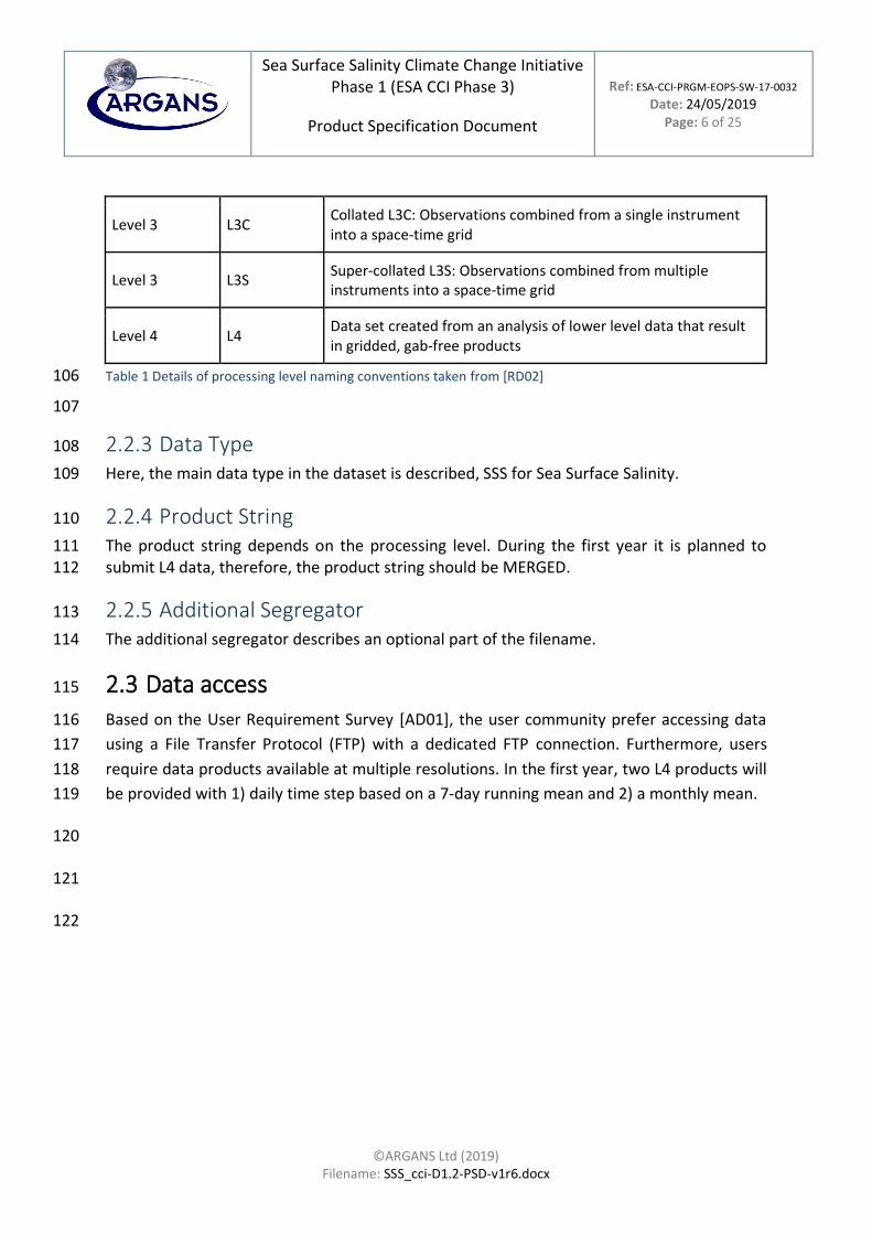
Table 1 Details of processing level naming conventions taken from [RD02] 106
107
2.2.3 Data Type 108
Here, the main data type in the dataset is described, SSS for Sea Surface Salinity. 109
2.2.4 Product String 110
The product string depends on the processing level. During the first year it is planned to 111 submit L4 data, therefore, the product string should be MERGED. 112
2.2.5 Additional Segregator 113
The additional segregator describes an optional part of the filename. 114
2.3 Data access 115
Based on the User Requirement Survey [AD01], the user community prefer accessing data 116
using a File Transfer Protocol (FTP) with a dedicated FTP connection. Furthermore, users 117
require data products available at multiple resolutions. In the first year, two L4 products will 118
be provided with 1) daily time step based on a 7-day running mean and 2) a monthly mean. 119
120
121
122
Sea Surface Salinity Climate Change Initiative Phase 1 (ESA CCI Phase 3)
Product Specification Document
Ref: ESA-CCI-PRGM-EOPS-SW-17-0032 Date: 24/05/2019
Page: 7 of 25
©ARGANS Ltd (2019) Filename: SSS_cci-D1.2-PSD-v1r6.docx
2.4 Attributes 123
Attributes are metadata stored in the NetCDF files. Here, a distinction is made between global 124 and variable attributes. The latter are specific for each variable and differ between data- and 125 NetCDF files. On the other hand, global attributes apply to the whole content of the NetCDF 126 file. 127
2.4.1 Global attributes 128
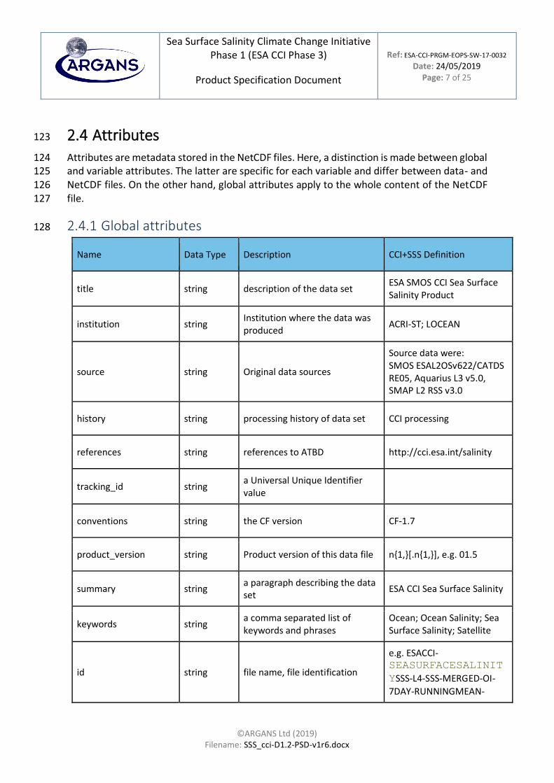
Name Data Type Description CCI+SSS Definition
title string description of the data set ESA SMOS CCI Sea Surface Salinity Product
institution string Institution where the data was produced
ACRI-ST; LOCEAN
source string Original data sources
Source data were: SMOS ESAL2OSv622/CATDS RE05, Aquarius L3 v5.0, SMAP L2 RSS v3.0
history string processing history of data set CCI processing
references string references to ATBD http://cci.esa.int/salinity
tracking_id string a Universal Unique Identifier value
conventions string the CF version CF-1.7
product_version string Product version of this data file n{1,}[.n{1,}], e.g. 01.5
summary string a paragraph describing the data set
ESA CCI Sea Surface Salinity
keywords string a comma separated list of keywords and phrases
Ocean; Ocean Salinity; Sea Surface Salinity; Satellite
id string file name, file identification
e.g. ESACCI-SEASURFACESALINIT
YSSS-L4-SSS-MERGED-OI-
7DAY-RUNNINGMEAN-

Sea Surface Salinity Climate Change Initiative Phase 1 (ESA CCI Phase 3)
Product Specification Document
Ref: ESA-CCI-PRGM-EOPS-SW-17-0032 Date: 24/05/2019
Page: 8 of 25
©ARGANS Ltd (2019) Filename: SSS_cci-D1.2-PSD-v1r6.docx
DAILY-25km-YYYYMMDD-fv1.6.nc
naming authority string European Space Agency - ESA Climate Office
keywords_vocabulary string NASA Global Change Master Directory (GCMD) Science Keywords
cdm_data_type string The THREDDS data type appropriate for this data set.
Grid
comment string Various information about the data set
Data are based on a 7-day running mean objectively interpolated
date_created string the date on which the data was created
yyyymmddThhmmssZ
date_modified string the date on which the data was modified
creator_name string Name of the creator ACRI-ST; LOCEAN
creator_url string Contact of the creator http://cci.esa.int/salinity
creator_email string Contact of the creator TBD
project string
the scientific project that produced the data: “Climate Change Initiative – European Space Agency”
Climate Change Initiative - European Space Agency
geospatial_lat_min float Decimal degrees North, Range: -90 to 90
-90.0
geospatial_lat_max float Decimal degrees North, Range: -90 to 90
90.0
geospatial_lon_min float Decimal degrees East, Range: -180 to 180
-180.0
geospatial_lon_max float Decimal degrees East, Range: -180 to 180
180.0

Sea Surface Salinity Climate Change Initiative Phase 1 (ESA CCI Phase 3)
Product Specification Document
Ref: ESA-CCI-PRGM-EOPS-SW-17-0032 Date: 24/05/2019
Page: 9 of 25
©ARGANS Ltd (2019) Filename: SSS_cci-D1.2-PSD-v1r6.docx
time_coverage_start string Time of the first measurement in the data file. Time format is ISO 8601.
yyyymmddThhmmssZ
time_coverage_end string Time of the last measurement in the data file. Time format is ISO 8601.
yyyymmddThhmmssZ
time_coverage_duration
string Length of time coverage 7 days - indicative date as centred date
time_coverage_resolution
string Time resolution 1 day
standard_name_vocabulary
string the name of the controlled vocabulary from which variable standard names are taken
NetCDF Climate and Forecast (CF) Metadata Conventions Version 1.7
licence string describe the restrictions to data access and distribution
ESA CCI Data Policy: free and open access
Table 2 List of global attributes. The contents of the first four columns of this table are reproduced from CCI Data 129 Standards Issue 2.0 [RD02]. 130
In the following Table 3 , the CCI project specific attributes are listed: 131
Name Data Type
Description CCI+SSS Definition
platform string Name of the Satellites MIRAS; SAC-D
sensor string Sensor name SMOS; Aquarius; SMAP
spatial_resolution string approximate resolution of the product
25 km
geospatial_lon_resolution string Decimal degrees 0.25
geospatial_lat_resolution string Decimal degrees 0.25
geospatial_lat_units string Degrees North degrees_north

Sea Surface Salinity Climate Change Initiative Phase 1 (ESA CCI Phase 3)
Product Specification Document
Ref: ESA-CCI-PRGM-EOPS-SW-17-0032 Date: 24/05/2019
Page: 10 of 25
©ARGANS Ltd (2019) Filename: SSS_cci-D1.2-PSD-v1r6.docx
geospatial_lon_units string Degrees East degrees_east
Table 3 Specific attributes to the CCI+SSS 132
133
2.4.2 Variable attributes 134
Name Data Type Description CCI+SSS Definition
standard_name string the standard name of the variable following the CF convention
sea_surface_salinity,longitude, latitude….
_FillValue same as variable data type
a value used to indicate array elements containing no valid data
NaN or a number?
units string Description of the units (text). Preferable S.I.
psu, degrees_east, degreas_north….
scale_factor same as variable data type
a factor needed to convert the variable into S.I. units
add_offset same as variable data type
offset needed to convert variable into S.I. units
long_name string a free text descriptive variable name
valid_min same as variable data type
Minimum valid value for this variable
valid_max same as variable data type
Maximum valid value for this variable
valid_range same as variable data type
Range of valid values for this variable
comment string important information about the variable
source string original data source

Sea Surface Salinity Climate Change Initiative Phase 1 (ESA CCI Phase 3)
Product Specification Document
Ref: ESA-CCI-PRGM-EOPS-SW-17-0032 Date: 24/05/2019
Page: 11 of 25
©ARGANS Ltd (2019) Filename: SSS_cci-D1.2-PSD-v1r6.docx
grid-mapping string This attribute is attached to data variables so that variables with different mappings may be present in a single file.
auxiliary_data_N string A string describing additional data used to produce this variable
Table 4 List of variable attributes. The contents of the first three columns of this table are 135 reproduced from CCI Data Standards 2.0 Document [RD02]. 136
Based on these conventions, the file will contain a 137
1. map of SSS 138
2. a corresponding map of uncertainties (random, systematic error, standard deviation 139
of the bias) 140
3. a corresponding map of quality flags (good/bad flags computed from Xi2 and number 141
of outliers) 142
4. a corresponding map of the number of outliers 143
5. Explained Variance PCTVAR= SSS_error/SSS_variability? 144
6. global attributes 145
146
The L4 files will contain a regular lat-lon map, the products at the different time steps (daily, 147
monthly) files share the same names for variables that appear in both products as well as 148
dimensions (latitude, longitude, SSS, QF etc.): 149
Dimensions: 150
time = 1 151
lat = 584 152
lon = 1388 153
154
lat 155
Size: 584x1 156
Dimensions: lat 157
Datatype: single 158

Sea Surface Salinity Climate Change Initiative Phase 1 (ESA CCI Phase 3)
Product Specification Document
Ref: ESA-CCI-PRGM-EOPS-SW-17-0032 Date: 24/05/2019
Page: 12 of 25
©ARGANS Ltd (2019) Filename: SSS_cci-D1.2-PSD-v1r6.docx
Attributes: 159
_FillValue = NaN 160
long_name = 'latitude' 161
units = 'degrees_north' 162
standard_name = 'latitude' 163
valid_range = -90.f, 90.f 164
165
lon 166
Size: 1388x1 167
Dimensions: lon 168
Datatype: single 169
Attributes: 170
_FillValue = NaN 171
long_name = 'longitude' 172
units = 'degrees_east' 173
standard_name = 'longitude' 174
valid_range = -180.f,180.f 175
176
time 177
Size: 1x1 178
Dimensions: time 179
Datatype: single 180
Attributes: 181
_FillValue = NaN 182

Sea Surface Salinity Climate Change Initiative Phase 1 (ESA CCI Phase 3)
Product Specification Document
Ref: ESA-CCI-PRGM-EOPS-SW-17-0032 Date: 24/05/2019
Page: 13 of 25
©ARGANS Ltd (2019) Filename: SSS_cci-D1.2-PSD-v1r6.docx
long_name = 'time' 183
units = 'days since 1970-01-01 00:00:00 UTC' 184
standard_name = 'time' 185
186
187
total_nobs 188
Size: 1388x584 189
Dimensions: lon,lat 190
Datatype: int16 191
Attributes: 192
_FillValue =0 193
long_name = Number of SSS in time interval' 194
coordinates = ' lon lat' 195
units = 'NA' 196
standard_name = 'number_of_observations' 197
valid_min =0 198
valid_max=10000 199
valid_range=0.f, 10000.f 200
scale_factor=1 201
add_offset=0 202
203
sss 204
Size: 1388x584 205
Dimensions: lon,lat 206
Sea Surface Salinity Climate Change Initiative Phase 1 (ESA CCI Phase 3)
Product Specification Document
Ref: ESA-CCI-PRGM-EOPS-SW-17-0032 Date: 24/05/2019
Page: 14 of 25
©ARGANS Ltd (2019) Filename: SSS_cci-D1.2-PSD-v1r6.docx
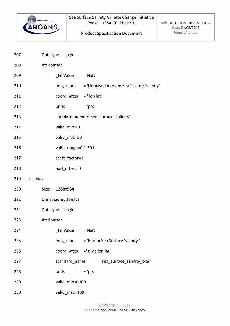
Datatype: single 207
Attributes: 208
_FillValue = NaN 209
long_name = 'Unbiased merged Sea Surface Salinity' 210
coordinates = ' lon lat' 211
units = 'pss' 212
standard_name = 'sea_surface_salinity' 213
valid_min =0 214
valid_max=50 215
valid_range=0.f, 50.f 216
scale_factor=1 217
add_offset=0 218
sss_bias 219
Size: 1388x584 220
Dimensions: ,lon,lat 221
Datatype: single 222
Attributes: 223
_FillValue = NaN 224
long_name = 'Bias in Sea Surface Salinity.' 225
coordinates =' time lon lat' 226
standard_name = 'sea_surface_salinity_bias' 227
units = 'pss’ 228
valid_min =-100 229
valid_max=100 230

Sea Surface Salinity Climate Change Initiative Phase 1 (ESA CCI Phase 3)
Product Specification Document
Ref: ESA-CCI-PRGM-EOPS-SW-17-0032 Date: 24/05/2019
Page: 15 of 25
©ARGANS Ltd (2019) Filename: SSS_cci-D1.2-PSD-v1r6.docx
valid_range=-100.f, 100.f 231
scale_factor=1 232
add_offset=0 233
234
sss_bias_std 235
Size: 1x1440x720 236
Dimensions: time,lon,lat 237
Datatype: float 238
Attributes: 239
_FillValue = NaN 240
long_name = 'Standard Deviation of the Bias in Sea Surface Salinity.' 241
coordinates = 'time lon lat' 242
standard_name = 'sea_surface_salinity_bias_std' 243
units = 'pss’ 244
valid_min =0 245
valid_max=100 246
valid_range=0.f, 100.f 247
scale_factor=1 248
add_offset=0 249
250
251
252
253
254

Sea Surface Salinity Climate Change Initiative Phase 1 (ESA CCI Phase 3)
Product Specification Document
Ref: ESA-CCI-PRGM-EOPS-SW-17-0032 Date: 24/05/2019
Page: 16 of 25
©ARGANS Ltd (2019) Filename: SSS_cci-D1.2-PSD-v1r6.docx
255
256
257
258
259
260
261
262
263
264
sss_random_error 265
Size: 1388x584 266
Dimensions:,lon,lat 267
Datatype: single 268
Attributes: 269
_FillValue = NaN 270
long_name = 'Sea Surface Salinity Random Error' 271
coordinates = ' lon lat' 272
standard_name = 'sea_surface_salinity_random_error' 273
units = 'pss’ 274
valid_min =0 275
valid_max=100 276
valid_range=0.f, 100.f 277
scale_factor=1 278

Sea Surface Salinity Climate Change Initiative Phase 1 (ESA CCI Phase 3)
Product Specification Document
Ref: ESA-CCI-PRGM-EOPS-SW-17-0032 Date: 24/05/2019
Page: 17 of 25
©ARGANS Ltd (2019) Filename: SSS_cci-D1.2-PSD-v1r6.docx
add_offset=0 279
280
281
noutliers 282
Size: 1388x584 283
Dimensions: lon,lat 284
Datatype: int16 285
Attributes: 286
_FillValue = 0 287
long_name = ''Count of the Number of Outliers within this bin cell'' 288
coordinates = ' lon lat' 289
standard_name = 'number_of_outliers' 290
units = 'NA’ 291
valid_min =0 292
valid_max=10000 293
valid_range=0.f, 10000.f 294
scale_factor=1 295
add_offset=0 296
297
pct_var 298
Size: 1388x584 299
Dimensions: lon,lat 300
Datatype: single 301
Attributes: 302

Sea Surface Salinity Climate Change Initiative Phase 1 (ESA CCI Phase 3)
Product Specification Document
Ref: ESA-CCI-PRGM-EOPS-SW-17-0032 Date: 24/05/2019
Page: 18 of 25
©ARGANS Ltd (2019) Filename: SSS_cci-D1.2-PSD-v1r6.docx
_FillValue = NaN 303
long_name = 'Percentage of Explained Sea Surface Salinity Variance by the 304 Sea Surface Salinity Standard Error' 305
coordinates = ' time lon lat' 306
standard_name = 'percentage_variance' 307
units = '%’ 308
valid_min =0 309
valid_max=100 310
valid_range=0.f, 100.f 311
scale_factor=1 312
add_offset=0 313
314
315
sss_qc 316
Size: 1388x584 317
Dimensions: lon,lat 318
Datatype: int16 319
Attributes: 320
_FillValue = 0 321
long_name = 'Sea Surface Salinity Quality. 1=good; 0=Bad' 322
coordinates =' lon lat’ 323
324
valid_min =0 325
valid_max=1 326

Sea Surface Salinity Climate Change Initiative Phase 1 (ESA CCI Phase 3)
Product Specification Document
Ref: ESA-CCI-PRGM-EOPS-SW-17-0032 Date: 24/05/2019
Page: 19 of 25
©ARGANS Ltd (2019) Filename: SSS_cci-D1.2-PSD-v1r6.docx
327
328
329

Sea Surface Salinity Climate Change Initiative Phase 1 (ESA CCI Phase 3)
Product Specification Document
Ref: ESA-CCI-PRGM-EOPS-SW-17-0032 Date: 24/05/2019
Page: 20 of 25
©ARGANS Ltd (2019) Filename: SSS_cci-D1.2-PSD-v1r6.docx
3 Spatial and temporal resolution, grid 330
format and projection 331
The majority of users have spoken out for a high resolution on temporal and spatial scale with 332
the highest accuracy possible at this resolution. Here some users wanted highly processed 333
data products (L3 and L4) while other users prefer to have low level products (L2). 334
Within Phase 1, the CCI+SSS project want to make highly processed L4 data accessible. Lower 335
processed data products based on the different satellites can be accessed via ESA or other 336
websites. Within Phase 2 the CCI+SSS project is planning to provide also debiased L2 and L3 337
data products. 338
3.1 Spatial resolution 339
To analyze at least mesoscale processes, many users require higher spatial resolution (1-100 340
km) than users, who focus on large scale processes (> 100 km). Based on the URD and based 341
on the capabilities of the different L-Band sensors, a specification of interpolated 25 km 342
resolution data based on 75 km resolution seems achievable. 343
3.2 Temporal resolution 344
Corresponding to the requirements regarding spatial resolution, the requirements for 345
temporal resolution varied dependent on the research interest. There was no clear majority 346
for the queried resolutions but a tendency to at least weekly data products. 347
Based on the URD and the capabilities of the sensors (SMOS & SMAP - 3 day observing cycle, 348
Aquarius 7 days), it seem sensible to offer a product with daily timesteps with a 7-day window. 349
For users who require lower temporal resolution a second product will be available with a 350
resolution of one month centred 1) at the first of each month and 2) centred at the 15th of 351
each month. The latter is comparable with climatological means. 352
3.3 Grid format, map projection and coverage 353
The majority of users have spoken out for data with a global coverage on a regular latitude-354
longitude grid. The first CCI+SSS product files will be delivered on the global (Cylindrical) 355
Equal-Area Scalable Earth Grid 2.0 (EASE 2), since it is used for other satellite SSS products 356
and therefore favors the compatibility between different data products. 357

Sea Surface Salinity Climate Change Initiative Phase 1 (ESA CCI Phase 3)
Product Specification Document
Ref: ESA-CCI-PRGM-EOPS-SW-17-0032 Date: 24/05/2019
Page: 21 of 25
©ARGANS Ltd (2019) Filename: SSS_cci-D1.2-PSD-v1r6.docx
4 Error budget and uncertainties 358
In order to characterize errors in the final product, analysis of the various sources of error 359 need to be conducted. Divergent user responses indicate that there is no one way of 360 communicating uncertainties that will suit everyone. 361
But the majority of users require random noise and systematic errors for each grid point as 362 well as detailed information about the error budget and bias correction. 363
4.1 Characterizing error and error budgeting 364
Error characterization and budgeting is described in the End-to-End ECV Uncertainty Budget 365
document, but to summarize, the uncertainty can be generally grouped into the following 366
primary categories: 367
⚫ uncertainties due to the measurement instrument 368
⚫ systematic errors in the retrieval algorithm 369
⚫ unknown uncertainties (e.g., spatial-temporal sampling errors) 370
Errors in each of these sources need to be propagated through the processing pixel by pixel 371
resulting in an error budget for each SSS grid point. 372
During the first phase of the CCI+SSS project, data sets will include information about random 373 noise and systematic errors, number of outliers and standard deviation of the bias. Error 374 estimation for the L4 CCI+SSS product is described in the End to End ECV Uncertainty 375 Document. 376
4.2 Data format for uncertainty information 377
The uncertainty products will be stored directly alongside the product in NetCDF, encoding 378
the uncertainty information as additional variable in NetCDF and bin them to their associated 379
variable by attributes and naming convention. This will be compatible with the CF 380
conventions. 381
382

Sea Surface Salinity Climate Change Initiative Phase 1 (ESA CCI Phase 3)
Product Specification Document
Ref: ESA-CCI-PRGM-EOPS-SW-17-0032 Date: 24/05/2019
Page: 22 of 25
©ARGANS Ltd (2019) Filename: SSS_cci-D1.2-PSD-v1r6.docx
5 Quality indicators and flags 383
5.1 Quality indicators 384
Based on the user requirements [AD001], the L4 CCI+SSS product must have quality 385
indicators. Users prefer to have data flagged dependent on their quality. In the case of the L4 386
product released during the first phase of the CCI+SSS project it is not possible to specify each 387
quality flag since the data sets are created from lower level data that result in gridded, higher 388
quality products. For production, a detailed documentation is needed including all steps in 389
the data and product delivery chain. Furthermore, uncertainty information is essential for the 390
users. 391
5.2 Flags 392
The detailed composition of the list of flags has not been defined yet and will follow in the 393 next version of this document. 394
395 396

Sea Surface Salinity Climate Change Initiative Phase 1 (ESA CCI Phase 3)
Product Specification Document
Ref: ESA-CCI-PRGM-EOPS-SW-17-0032 Date: 24/05/2019
Page: 23 of 25
©ARGANS Ltd (2019) Filename: SSS_cci-D1.2-PSD-v1r6.docx
6 Summary 397
The aim of this document was to transform the user requirements summarized in the URD 398
into a set of product specifications for input into Task 2 (algorithm development etc.) of the 399
CCI+SSS project. 400
1. Two CCI+SSS products on a regular latitude longitude grid will be provided during the 401 first year of the CCI+SSS project (Table 5). 402
2. Data products will include uncertainty information (random noise + systematic error 403 (bias), standard deviation of the systematic error, number of outliers, Chi2 of applied 404 correction to homogenize SMOS, SMAP and Aquarius). 405
3. Additional information (SST, Sea Ice) will not be provided with the products at this 406 stage of the project. 407
4. Quality indicators will be provided in the L4 data. 408 5. At each step of processing, the error will be quantified, propagated through the 409
processing chain and well documented. 410 6. Updates of the products will be given 2 times during the first year of the CCI+SSS 411
project. 412 7. Data will be produced in CF-compliant NetCDF-v4 format 413 8. The NetCDF data will be distributed through an FTP site. 414
415

Sea Surface Salinity Climate Change Initiative Phase 1 (ESA CCI Phase 3)
Product Specification Document
Ref: ESA-CCI-PRGM-EOPS-SW-17-0032 Date: 24/05/2019
Page: 24 of 25
©ARGANS Ltd (2019) Filename: SSS_cci-D1.2-PSD-v1r6.docx
Level Decorrelation timescales
Spatial Smoothing scale
Temporal timesteps
Spatial grid size
Coverage
L2 - - - - -
L3 - - - - -
L4 weekly 50 km (TBC) daily (based on 7-day running means)
25 km global 01/2010-10/2018
L4 30 days 50 km (TBC) centred at each 1st and 15th day of the month
25 km global 01/2010-10/2018
Table 5 Summary of the specifications of the first dataset CCI+SSS project (dataset year1). L2 and L3 products 416 will be provided during the second delivery. 417
418 419
420

Sea Surface Salinity Climate Change Initiative Phase 1 (ESA CCI Phase 3)
Product Specification Document
Ref: ESA-CCI-PRGM-EOPS-SW-17-0032 Date: 24/05/2019
Page: 25 of 25
©ARGANS Ltd (2019) Filename: SSS_cci-D1.2-PSD-v1r6.docx
End of Document 421