Procurement, Acquisition and Construction - NOAA€¦ · procurement, acquisition, and construction...
22
4-1 National Oceanic and Atmospheric Administration PAC Chapter 4 Procurement, Acquisition and Construction
Transcript of Procurement, Acquisition and Construction - NOAA€¦ · procurement, acquisition, and construction...

4-1
National Oceanic and Atmospheric Administration PAC
Chapter 4
Procurement, Acquisition and Construction
4-2
National Oceanic and Atmospheric Administration PAC
FY 2007 Enacted
FY 2008 Enacted
FY 2009 Request
Increase (Decrease)
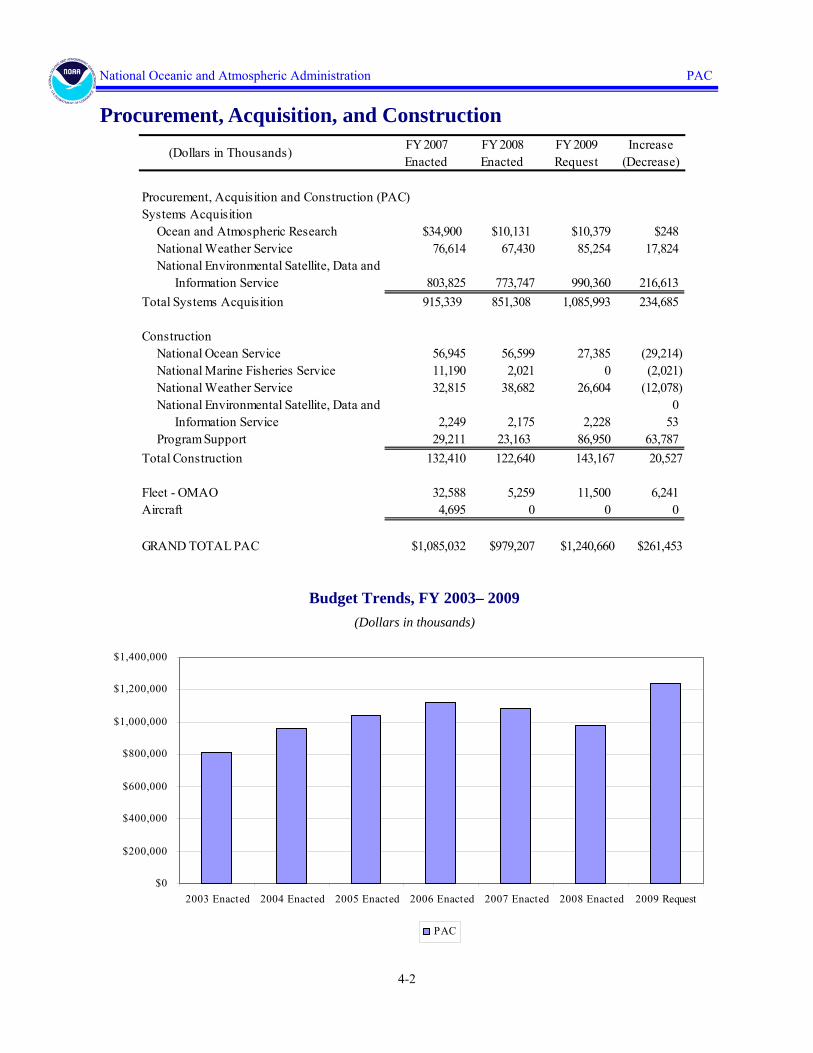
Procurement, Acquisition and Construction (PAC)Systems Acquisition Ocean and Atmospheric Research $34,900 $10,131 $10,379 $248 National Weather Service 76,614 67,430 85,254 17,824 National Environmental Satellite, Data and Information Service 803,825 773,747 990,360 216,613Total Systems Acquisition 915,339 851,308 1,085,993 234,685
Construction National Ocean Service 56,945 56,599 27,385 (29,214) National Marine Fisheries Service 11,190 2,021 0 (2,021) National Weather Service 32,815 38,682 26,604 (12,078) National Environmental Satellite, Data and 0 Information Service 2,249 2,175 2,228 53 Program Support 29,211 23,163 86,950 63,787Total Construction 132,410 122,640 143,167 20,527
Fleet - OMAO 32,588 5,259 11,500 6,241Aircraft 4,695 0 0 0
GRAND TOTAL PAC $1,085,032 $979,207 $1,240,660 $261,453
(Dollars in Thousands)
Procurement, Acquisition, and Construction
$0
$200,000
$400,000
$600,000
$800,000
$1,000,000
$1,200,000
$1,400,000
2003 Enacted 2004 Enacted 2005 Enacted 2006 Enacted 2007 Enacted 2008 Enacted 2009 Request
PAC
Budget Trends, FY 2003– 2009 (Dollars in thousands)

4-3
National Oceanic and Atmospheric Administration PAC
www.ofa.noaa.gov
NOAA’s Procurement, Acquisition, and Construction (PAC) account captures the cost of ac-quiring and improving capital assets, which are mission-critical to all agency programs and con-tribute significantly to achieving each of NOAA’s Strategic Goals. This account is grouped by line office into three common activities: “Systems Acquisition,” which includes projects that will have a major impact on NOAA’s ability to monitor and to forecast weather and climate change on a global basis; “Construction,” which includes projects involving new construction, or major modification of existing facilities; and “Fleet and Aircraft Replacement,” which in-cludes funding to support modernization of NOAA’s fleet of ships and aircraft either through new construction, major modification to existing assets, or long-term acquisition of capacity from third parties.
ADJUSTMENTS TO BASE:
The NOAA Procurement, Acquisition, and Construction (PAC) requests adjustments to FY 2009 Base of $2,092,000.
PAC PROGRAM CHANGE HIGHLIGHTS FOR FY 2009:
For FY 2009, NOAA requests a net increase of $311,860,000 for a total of $1,240,660,000 for procurement, acquisition, and construction programs. These changes include 21 major system programs, seven construction projects and two fleet projects. Detailed numeric breakouts are located in Chapter 6, Special Exhibits. Descriptions of each request by line item are located in the NOAA FY 2009 Technical Budget. Note that outyear figures are estimates, and future re-quests will be determined through the annual budget process.

4-4
National Oceanic and Atmospheric Administration PAC
SYSTEMS ACQUISITION $1,085,993,000
Office of Oceanic and Atmospheric Research $10,379,000
Research Supercomputing
NOAA requests an increase of $248,000 to increase the base levels of funding for various on-going programs within this subactivity to that recommended in the FY 2008 President’s Budget. This increase will return NOAA’s Geophysical Fluid Dynamics Laboratory in Princeton, NJ, to its traditional base level of $10,379,000 in PAC funding to support a very large, scalable com-puter system that provides: (1) critical computing, storage, and analysis capabilities; (2) model development; (3) infrastructure support; and (4) data services for meeting the objectives of the Administration’s Climate Change Science Program (CCSP). Research into expanding the sci-entific understanding of the physical, chemical, and biological processes that govern the behav-ior of the Earth System requires a special focus on the development and utilization of large-scale computer simulations for environmental modeling.
As part of the CCSP, NOAA plays a leading role in developing these computer simulations as well as hosting the High-Performance Computing Systems (HPCS) on which they run. The CCSP establishes NOAA’s Geophysical Fluid Dynamics Laboratory (GFDL) as one of two na-tional Climate Modeling Centers that will coordinate and accelerate climate modeling activities and provide relevant decision-support information on a timely basis. To this end, the CCSP Strategic Plan specifically calls for an increase in computational resources to enable systematic generation of model products needed by the impacts and policy communities.
This climate computing is now integrated into NOAA’s new R&D HPCS. The R&D HPCS represents a new, holistic, “One-NOAA” approach to planning, acquiring, and managing its HPC resources and will be fully supported with the requested funding. Moreover, this comput-ing supports NOAA’s emerging partnerships with other Federal agencies’ climate programs and enables NOAA to leverage its leadership-class high-performance computing systems to meet NOAA mission goals.
Annual Funding Requirements(BA in Thousands)
FY2008FY 2009 Estimate
FY2010 Estimate
FY2011 Estimate
FY2012 Estimate
ResearchSupercomputing/CCRI 10,121 10,379 10,379 10,379 10,379
4-5
National Oceanic and Atmospheric Administration PAC
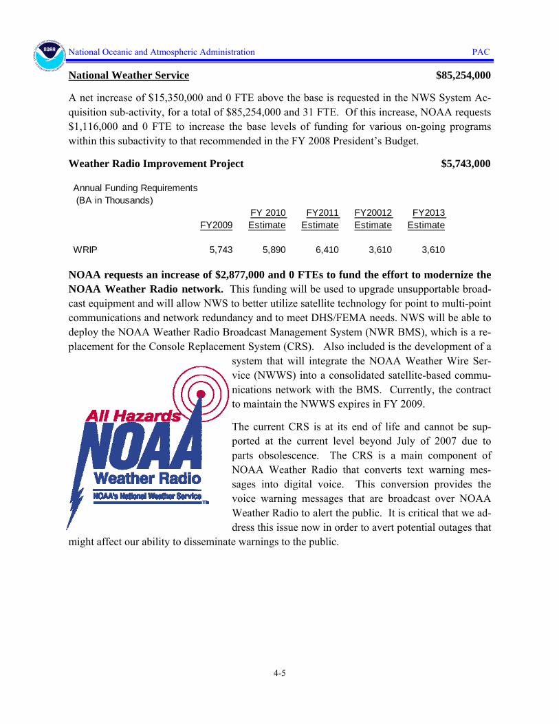
National Weather Service $85,254,000
A net increase of $15,350,000 and 0 FTE above the base is requested in the NWS System Ac-quisition sub-activity, for a total of $85,254,000 and 31 FTE. Of this increase, NOAA requests $1,116,000 and 0 FTE to increase the base levels of funding for various on-going programs within this subactivity to that recommended in the FY 2008 President’s Budget.
Weather Radio Improvement Project $5,743,000
NOAA requests an increase of $2,877,000 and 0 FTEs to fund the effort to modernize the NOAA Weather Radio network. This funding will be used to upgrade unsupportable broad-cast equipment and will allow NWS to better utilize satellite technology for point to multi-point communications and network redundancy and to meet DHS/FEMA needs. NWS will be able to deploy the NOAA Weather Radio Broadcast Management System (NWR BMS), which is a re-placement for the Console Replacement System (CRS). Also included is the development of a
system that will integrate the NOAA Weather Wire Ser-vice (NWWS) into a consolidated satellite-based commu-nications network with the BMS. Currently, the contract to maintain the NWWS expires in FY 2009.
The current CRS is at its end of life and cannot be sup-ported at the current level beyond July of 2007 due to parts obsolescence. The CRS is a main component of NOAA Weather Radio that converts text warning mes-sages into digital voice. This conversion provides the voice warning messages that are broadcast over NOAA Weather Radio to alert the public. It is critical that we ad-dress this issue now in order to avert potential outages that
might affect our ability to disseminate warnings to the public.
Annual Funding Requirements (BA in Thousands)
FY2009FY 2010 Estimate
FY2011 Estimate
FY20012 Estimate
FY2013 Estimate
WRIP 5,743 5,890 6,410 3,610 3,610

4-6
National Oceanic and Atmospheric Administration PAC
Advanced Weather Interactive Processing System $19,064,000
NOAA requests an increase of $6,605,000 and 0 FTEs for the Advanced Weather Interac-tive Processing System (AWIPS)/NOAAPort. The Advanced Weather Information Process-ing System (AWIPS) is America’s weather and flood warning system. NWS must upgrade AWIPS to transform its service delivery to DHS, FAA, emergency managers, decision makers, the American public and industry. Emergency managers, DHS, and industry are demanding increased lead time and more precision in weather, flood, and hurricane forecasts to improve their decisions for resource planning, evacuation planning, and business operations. These de-cisions are potentially life saving and have multi-million dollar impacts on the economy and
livelihoods. Customers and users of NWS products and services will fully exploit NOAA investments through this transformation.
Originally built in the 1990s, AWIPS is unable to meet the demands for in-creased accuracy, precision, and timeli-ness of warnings nor with the demands of 21st century science. Although patched numerous times, AWIPS has reached the point where further patches only deliver small incremental im-provements. These improvements are increasingly insufficient to meet the
service demands of DHS, FAA, emergency managers, and the American public. NOAA/NWS must undertake this critical investment to ensure overall NWS forecast, warning, and service improvements by providing the capacity to exploit NOAA’s planned investments such as ad-vanced weather satellites (GOES-R, NPOESS), Advanced Numerical Weather Prediction, and NEXRAD Super Resolution and Dual Polarization.
AWIPS is also the primary source of weather information to America’s Aviation infrastructure. NWS forecasters at critical aviation weather centers and weather forecast offices depend on AWIPS to prepare aviation forecasts that enable FAA decision makers to minimize weather-related delays. Additionally, the Next Generation Air Traffic Control System will require the future AWIPS infrastructure provided by this initiative.
(BA in Thousands)
FY 2009FY2010
EstimateFY2011
EstimateFY2012
EstimateFY2013
Estimate
AWIPS 19,064 12,764 12,764 12,764 12,764

4-7
National Oceanic and Atmospheric Administration PAC
With this investment, NWS will capitalize on the new AWIPS II architecture currently being deployed. This investment will transform NWS service delivery to:
• Ensure capability to deliver all available forecast information to WFOs;
• Update the infrastructure to incorporate modern architecture to meet mission needs;
• Improve data and service delivery with smart push-smart pull methods;
• Develop an integrated remote service delivery capability (thin client) to support Emergency Managers and Fire Weather;
• Tailor delivery to customer-centric formats and standards and create the flexibility to change with their changes;
• Deliver graphical collaboration tools for WFOs, RFCs, NCEP Centers, Emergency Manag-ers, NOAA Components, and partners for improved accuracy and consistency of products and service;
• Integrate 7 AWIPS subsystems into one integrated system increasing effectiveness and effi-ciency while greatly reducing operating and maintenance costs; and
• Update data visualization (3D) to improve detection of severe weather events.
NOAA Profiler Conversion $9,730,000
NOAA requests an increase of $4,752,000 and 0 FTEs to replace NOAA Profiler transmit-ters that interfere with Search and Rescue sensors and to conduct a tech refresh of the 20-year-old network. This increase will allow NWS to upgrade/convert twelve of the profilers in FY 2009. The Wind Profilers, vertical look-ing radars installed in 1988, are used as input for numerical (computer) weather models that predict clouds, precipitation, and tem-perature. The data also provide important indicators of where severe weather such as tornadoes and winter storms may form and is used for issuing aviation advisories and wild-fire predictions at local Weather Forecast Of-fices (WFOs). Research has shown that
Annual Funding Requirements (BA in Thousands)
FY2009FY 2010 Estimate
FY2011 Estimate
FY2012 Estimate
FY2013 Estimate
NOAA ProfilerConversion 9,730 4,870 4,870 0 0

4-8
National Oceanic and Atmospheric Administration PAC
Wind Profiler data improves accuracy and lead times for tornado, severe thunderstorm, flash flood, and winter storm warnings.
Thirty-two of the 37 wind profilers are using an experimental transmitter frequency of 404 megahertz (MHz) issued by the National Telecommunications and Information Administration (NTIA). This frequency is close to the 406 MHz frequency used by search and rescue (SAR) sensors being launched on the European Space Agency’s Galileo satellite constellation. Be-cause the profiler transmitter frequency interferes with the SAR frequency, thirty operational 404 MHz wind profilers require their transmitters to be converted to 449 MHz before the launch of the new satellites by 2011.
In addition to the 30 operational sites using 404MHz, there are two additional 404 MHz wind profilers at the National Reconditioning Center and the National Weather Service Training Cen-ter (used for testing and training). There are also five wind profilers in the NPN that operate at the non-interfering 449 MHz frequency: three in Alaska, one in Syracuse, NY, and one in Platteville, CO.
National Environmental Satellite, Data, $990,360,000 and Information Service
A net increase of $217,639,000 and 0 FTE is requested in the NESDIS Systems Acquisition subactivity, for a total of $990,360,000 and 153 FTE. Of this increase, NOAA requests $357,000 and 0 FTE to restore funding to increase the base levels of funding for various on-going programs within this subactivity to that recommended in the FY 2008 President’s Budget..
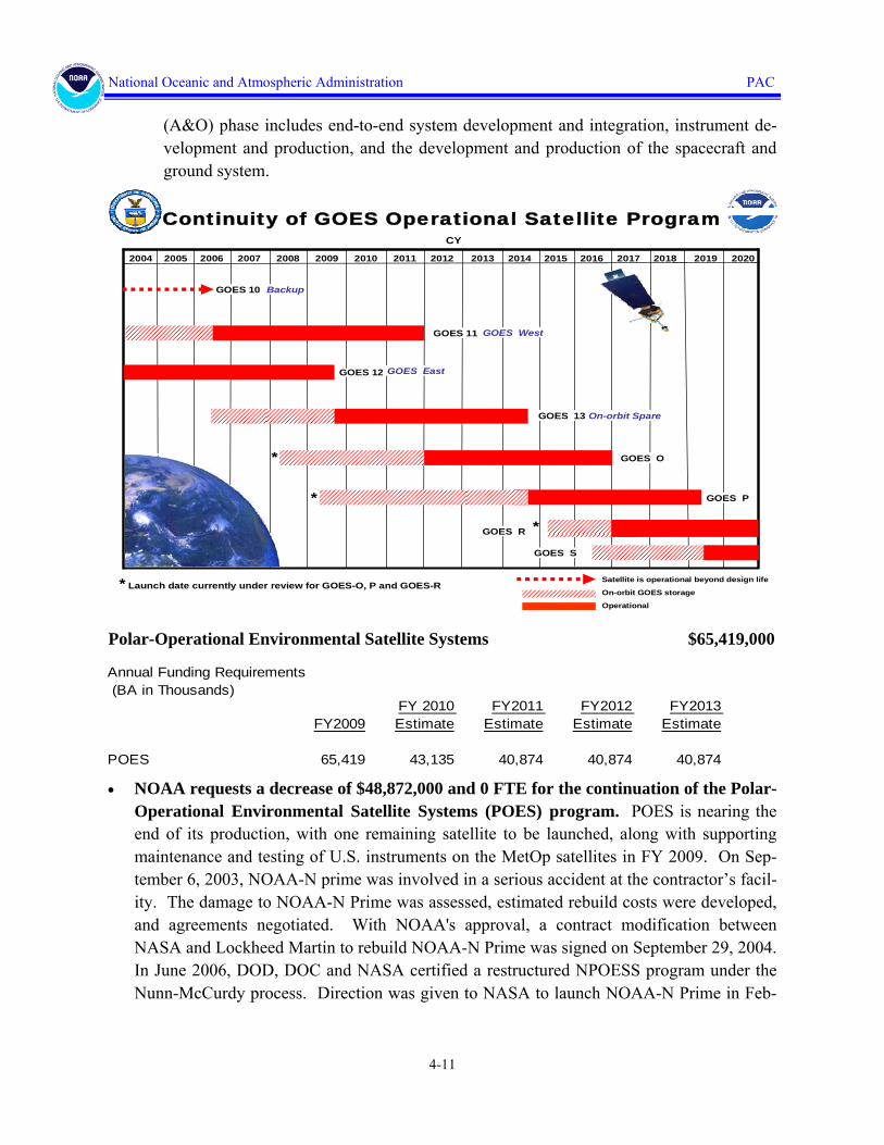
Geostationary Operational Environmental Satellites
Geostationary Operational Environmental Satellite (GOES):
NOAA requests a net increase of $235,191,000 and 0 FTE for the Geostationary Opera-tional Environmental Satellites (GOES) to fund GOES-N and GOES-R series satellites which serve as the Nation’s continuous severe weather sentinels in space.
• NOAA requests a decrease of $7,036,000 and 0 FTE for the GOES-N Series. The GOES-N Series is nearing the end of its production, with two remaining satellites to be launched; GOES-O is being prepared for launch in 2008 and GOES-P is currently in stor-
Annual Funding Requirements(BA in Thousands)
FY2009FY 2010 Estimate
FY2011 Estimate
FY2012 Estimate
FY2013 Estimate
GOES-N 73,263 57,601 49,500 45,894 39,201GOES-R 477,000 737,000 848,000 826,000 816,000
GOES Total 550,263 794,601 897,500 871,894 855,201

4-9
National Oceanic and Atmospheric Administration PAC
age. Specific launch dates are currently under review. The NOAA GOES program contin-ues the development, procurement, and launch of the GOES-N series of satellites. The spacecraft contract for the GOES–N series is a firm fixed price contract. The GOES-N se-ries program also includes separate contracts for the instruments, one for the imager and sounder and one for the Solar X-ray Imager. The instrument contractors have completed delivery of all flight model instruments.
• NOAA requests an increase of $242,227,000 and 0 FTE for the GOES-R Series. The FY2009 request continues the amount requested for FY 2009 in the FY 2008 President’s Budget. Additional resources are requested in FY 2010 and beyond to mitigate program risks. The current expected life-cycle cost of the program is $7.672 billion through 2028
The launch date for GOES-R will be delayed up to four months from December 2014 to April 2015 as a result of the change in FY 2008 funding provided in the FY 2008 Omnibus Bill. This delay to the launch of GOES-R will increase the potential risk to the overall con-tinuity of GOES data coverage in the event of a failure of one either GOES-O or GOES-P. The reduction also im-pacted the total life cycle cost of the program due to ineffi-ciencies created in the schedule.
NOAA operates a system of environmental satellites in geo-stationary orbits to provide continuous weather imagery and monitoring of meteorological data for the United States, Latin America, much of Canada and most of the Atlantic and Pacific ocean basins. Geostationary Operational Environ-mental Satellites (GOES) provide critical atmospheric, oce-anic, climatic, and solar products supporting weather fore-casting and warnings, climatologic analysis and prediction, ecosystems management, and safe and efficient public and private transportation. The GOES satellites also provide a platform for space environmental observations, and auxiliary communications services that provide for GOES data rebroadcast, data collection platform relay, low resolution imagery, emergency weather communications, and satellite aided search and rescue.
GOES-R is a collaborative development and acquisition effort between NOAA and the Na-tional Aeronautics and Space Administration (NASA). Program activities occur at the co-located Program and Project Offices at Goddard Space Flight Center (GSFC), Greenbelt, MD.
The GOES-R program acquisition and management strategy was restructured at the end of the Program Definition and Risk Reduction (PDRR) Phase from a single-system prime NOAA contract acquisition to an inter-agency dual-contract acquisition for the Acquisition and Operations (A&O) Phase of the Program. Under a dual-contract acquisition strategy,

4-10
National Oceanic and Atmospheric Administration PAC
the National Aeronautics and Space Administration (NASA) will procure the Space Seg-ment and NOAA will procure the Ground Segment. The overall System Engineering and Integration will be performed by the GOES-R Program Office. As a result of the change to the acquisition and management strategy, NOAA and NASA have agreed to tailor proce-dures to apply to the GOES-R program in order to meet the unique demands of this joint inter-agency acquisition. These needs include safeguarding NOAA’s oversight of the entire GOES-R program, including the Flight Project (e.g., Space Segment) and the Ground Seg-ment Project (Ground Segment) and also safeguarding NASA’s effective exercise of its ex-pertise over the Flight Project.
• GOES observations allow continuous monitoring of the Earth from the same angle dur-ing the tracking/detection of severe storms, atmospheric moisture deltas, mesoscale scanning, currents flow dynamics, and atmospheric chemical (particle) that cannot be achieved from a non-stationary orbit without increased error rates and lost data seg-ments. NOAA maintains an on-orbit spare to complement the two operational GOES satellites. This on-orbit spare philosophy allows NOAA to quickly replace a failed sat-ellite by re-positioning an on-orbit satellite. To facilitate this strategy, NOAA plans the launch of the next satellite to coincide with the planned switchover of the on-orbit spare to operational status.
• The GOES-R series satellites will not only provide critical weather observations for se-vere weather events such as hurricanes, but will also provide key enhancements in ob-servational capabilities for climate, oceans and coasts, and the space environment. Spe-cific improvements include:
• Spatial resolution will improve from 1 km to 0.5 km and provides the ability to issue severe storm warnings and protect life and property at neighborhood vs. regional levels.
• Infrared imagery will improve from 4 km to 2 km, enhancing NOAA’s ability to moni-tor and track snowfall and ice storms and issue winter storm warnings and spring snow melt advisories.
• Full disk image availability will improve from every 30 minutes to every five minutes, an improvement that is critical to monitoring severe storm activity and will result in ear-lier warnings to populations at risk.
• Lightning mapper will provide improved warnings of severe thunderstorms, tornados, and potential lightning strikes, resulting in safer and more efficient flight route planning over water and land.
• Funding will be used for systems engineering, continued development of satellite in-struments, risk reduction activities, transition to the system-level acquisition and opera-tions (A&O) phase of the program, and the NOAA-NASA government program office in support of an initial GOES-R launch date in 2015. The Acquisition and Operations
4-11
National Oceanic and Atmospheric Administration PAC
(A&O) phase includes end-to-end system development and integration, instrument de-velopment and production, and the development and production of the spacecraft and ground system.
Polar-Operational Environmental Satellite Systems $65,419,000
• NOAA requests a decrease of $48,872,000 and 0 FTE for the continuation of the Polar-Operational Environmental Satellite Systems (POES) program. POES is nearing the end of its production, with one remaining satellite to be launched, along with supporting maintenance and testing of U.S. instruments on the MetOp satellites in FY 2009. On Sep-tember 6, 2003, NOAA-N prime was involved in a serious accident at the contractor’s facil-ity. The damage to NOAA-N Prime was assessed, estimated rebuild costs were developed, and agreements negotiated. With NOAA's approval, a contract modification between NASA and Lockheed Martin to rebuild NOAA-N Prime was signed on September 29, 2004. In June 2006, DOD, DOC and NASA certified a restructured NPOESS program under the Nunn-McCurdy process. Direction was given to NASA to launch NOAA-N Prime in Feb-
Annual Funding Requirements (BA in Thousands)
FY2009FY 2010 Estimate
FY2011 Estimate
FY2012 Estimate
FY2013 Estimate
POES 65,419 43,135 40,874 40,874 40,874
Satellite is operational beyond design life
On-orbit GOES storage
Continuity of GOES Operational Satellite Program
2009 20102004 2005 2006 2007 2008 2011 2012 2013 2014 2015 2016 2017 2018 2019 2020
GOES 10 Backup
GOES 11
CY
GOES EastGOES 12
GOES O
Operational
GOES R
GOES West
GOES 13 On-orbit Spare
GOES S
GOES P
* Launch date currently under review for GOES-O, P and GOES-R
*
*
*
4-12
National Oceanic and Atmospheric Administration PAC
ruary 2009. This action will minimize the potential gap in polar-orbiting data and services until the first NPOESS satellite is fully operational in 2014.
National Polar-orbiting Operational Environmental Satellite Systems $287,985,000
• NOAA requests a decrease of $42,984,000 and 0 FTE for the continuation of the tri-agency NPOESS program that will replace the NOAA POES program after completion of the current NOAA K-N Prime series of satellites. The program adjustment allows the DOC budget for the NPOESS to come into alignment with the DoD’s certified Nunn-McCurdy program estimate. This request represents NOAA’s share of the converged NOAA/DoD/NASA program.
In FY 2009, funds are required to continue the development and production of the NPOESS spacecraft and instruments. Sensors that will fly on the NPOESS Preparatory Project (NPP) will be integrated onto the NPP spacecraft. Continued development of these instruments is critical for their timely and cost effective delivery.
Climate Sensors (CERES, TSIS, and Climate Data Record Support) $74,000,000
• NOAA requests an increase of $74,000,000 and 0 FTE for the development of the Clouds and the Earth’s Radiant Energy System (CERES) and Total Solar Irradiance Sensor (TSIS) climate sensors, which were previously de-manifested from National Polar-orbiting Operational Environmental Satellite System (NPOESS). This funding will support initial work on Climate Data Records. The joint assessment conducted with the Office of Science and Technology Policy, NOAA, and NASA has emphasized the importance of sus-taining the CERES and TSIS climate data series without gaps. NOAA and NASA will work together to explore the most cost-effective options for launching these climate sensors to fill the near-term data gap.
CERES measures the Earth radiation budget. Accurate observations of the Earth’s radia-
Annual Funding Requirements (BA in Thousands)
FY2009FY 2010 Estimate
FY2011 Estimate
FY2012 Estimate
FY2013 Estimate
NPOESS 287,985 381,794 420,332 415,829 436,270
Annual Funding Requirements (BA in Thousands)
FY2009FY 2010 Estimate
FY2011 Estimate
FY2012 Estimate
FY2013 Estimate
Climate Sensors 74,000 74,000 74,000 74,000 74,000

4-13
National Oceanic and Atmospheric Administration PAC
tion are essential to determine the causes of climate variability and change. Overlap be-tween space-based sensors is critical to confidently detect and monitor the small changes in the Earth’s radiation balance capable of affecting climate change.
TSIS measures the total energy of the sun incident on Earth. This crucial measurement can be accurately determined only above the atmosphere. Precise, long-term observations of the total energy output of the sun are required to identify and isolate natural solar variations that impact climate in contrast to other factors, such as human influences on climate.

4-14
National Oceanic and Atmospheric Administration PAC
CONSTRUCTION $143,167,000
National Ocean Service $27,385,000
A net increase of $7,135,000 and 0 FTE above the base is requested in the NOS Construction sub-activity, for a total of $27,385,000 and 1 FTE. Of this increase, NOAA requests $135,000 and 0 FTE to restore funding to increase the base levels of funding for various on-going pro-grams within this subactivity to that recommended in the FY 2008 President’s Budget.
Coastal and Estuarine Land Conservation Program
NOAA requests an increase of $7,000,000 for a total of $15,000,000 and 1 FTE, to con-serve coastal and estuarine lands which have significant value and support NOAA’s stew-ardship requirements through the Coastal and Estuarine Land Conservation Program (CELCP). With these funds, NOAA will provide funding for land conservation projects iden-tified through a competitive selection process, based on habitat types or geographic areas identi-fied by coastal states as having high ecological, conservation, recreational, historic or aesthetic value that are threatened by development, such as tidal or freshwater wetlands, stream buffers, and floodplains. Federal funding requires matching funds, which leverage additional state, local or pri-vate contributions. As part of this voluntary pro-gram, coastal states assess their priority needs for land conservation and provide a clear process for identifying and nominating projects to a national selection process. The program’s focus on “project areas” encourages public/private partnerships to protect priority areas. State or local governments own the land or interests in land, which may be acquired from willing sellers only, and ensure long-term protection and provide public access for passive recreational opportunities or other public benefit.
NOAA has developed and issued guidelines delineating criteria for grant awards and a process for conducting a national competitive grants program under the CELCP. The program gives priority to lands which can be effectively managed and protected and which have significant ecological value. This request supports efforts to protect important stream corridors and habi-
Annual Funding Requirements (BA in Thousands)
FY2009FY 2010 Estimate
FY2011 Estimate
FY2012 Estimate
FY2013 Estimate
CELCP 15,000 15,000 15,000 15,000 15,000

4-15
National Oceanic and Atmospheric Administration PAC
tats important to anadromous fish, reduce the flow of polluted runoff into coastal waters, lessen the impacts of coastal flooding from severe storm events, and provide opportunities for coastal recreation and nature-based tourism. This request would also enable NOAA to support strate-gic program planning and management of the CELCP as a competitive program.
National Weather Service Construction $26,604,000
A net increase of $232,000 and 0 FTE above the base is requested in the NWS Construction sub-activity, for a total of $26,604,000 and 0 FTE. This increase will restore funding to in-crease the base levels of funding for various on-going programs within this subactivity to that recommended in the FY 2008 President’s Budget.
Program Support Construction $86,950,000
Pacific Regional Center $40,250,000
NOAA requests an increase of $40,250,000 and 0 FTE for a total of $60,250,000 for con-tinuation of construction of the new Pacific Regional Center (PRC) on Ford Island in Honolulu, HI. This requested increase will enable NOAA to meet the most pressing facilities needs for NOAA programs in Hawaii.
Funding at the requested level in FY 2009 will allow NOAA to continue support for construc-tion of Buildings 176 and 175 of the PRC, enabling NOAA to relocate operations from the cur-rent, deteriorating Kewalo Basin and Dole Street Lab Facilities.
Completion of this renovation will allow NOAA to consolidate fish-eries research, and management programs, which will also be co-located with docking space for the three NOAA ships currently based in Hawaii. Full consolidation (proposed with out-year funding) at the Ford Island location of NOAA programs and operations on the island of O’ahu (with the exception of the Weather Forecast Office) will provide financial, operational, and programmatic benefits to NOAA over existing, dispersed leased space locations.
Annual Funding Requirements
(BA in Thousands)
FY 2009FY 2010 Estimate
FY 2011 Estimate
FY 2012 Estimate
FY 2013 Estimate
Pacific Regional Center 60,250 77,081 63,046 750 750

4-16
National Oceanic and Atmospheric Administration PAC
Southwest Fisheries Science Center $15,000,000
NOAA requests an increase of $12,072,000 and 0 FTE for a total of $15,000,000 to com-plete the design and begin initial site work for construction of the replacement laboratory facility for the Southwest Fisheries Science Center.
NOAA’s National Marine Fisheries Service (NMFS) Southwest Fisheries Science Center (SWFSC) headquarters in La Jolla, California, is at risk due to continuing cliff erosion. Numer-ous geotechnical studies of the current site have identified natural cliff erosion as inevitable and have stated that failure of the cliff (and facilities located on the cliff) is inescapable. The cliff erosion has forced NOAA to develop plans to abandon two of the four buildings at this facility and move staff to temporary leased space. This temporary housing arrangement adversely af-fects ongoing operations and science at the facility and is not a long-term solution. The funding requested will complete the design and initial preparations for the replacement facility after a merit-based analysis to determine the facility's location.
This initiative will enable NOAA to address the ongoing natural bluff erosion threatening the current site, and the NOAA programs supported at this site. NOAA conducts scientific research on critical fisheries management issues at the SWFSC. These scientific research and fisheries management programs have extended social and economic impacts in the Pacific. This project will enable NOAA to continue to conduct these important programs in a safe environment.
Annual Funding Requirements(BA in Thousands)
FY 2009FY 2010 Estimate
FY 2011 Estimate
FY 2012 Estimate
FY 2013 Estimate
Southwest Fisheries Science Center 15,000 0 0 0 0

4-17
National Oceanic and Atmospheric Administration PAC
Fairbanks, AK Semi-Permanent Operations Facility Replacement $11,700,000
NOAA requests an increase of $11,700,000 and 0 FTE for a total of $11,700,000 to avoid the catastrophic failure of the NESDIS Operations Building Complex, a component of the NESDIS Command and Data Acquisition Station (CDAS) in Fairbanks, Alaska by replac-ing the current facility with a semi-permanent Operations Facility. The requested fund-ing would support installation of a semi-permanent replacement structure for the at-risk Operations Complex. The NOAA/NESDIS Fairbanks Satellite Operations Facility (FSOF) building in Fairbanks, AK was built by NASA in the late 1960s. Consistent with a plan for the Bureau of Land Management to turn over the Facilities Command Data and Acquisition Site land to the state of Alaska, it was originally presumed that the government use of the Fairbanks location would expire. Therefore, the structures built were only semi-permanent, with a life ex-pectancy of just 20 years. In 1985, NOAA took over operations of the Fairbanks facility. The Fairbanks facility is located in a seismic zone and operates in severe Sub-Arctic conditions,
with temperatures routinely reaching minus 50 degrees Fahrenheit during the winter months. The Army Corps of Engineers (COE) conducted an assessment of the Operations Building Complex and identified existing structural deficiencies, building code violations, potential haz-ards, and other weaknesses (including electrical, mechanical, and life safety systems). The Army Corps of Engineers’ study of the facility completed in 2006 projected a major structural failure in the next five years. The current Operations Building Complex is no longer capable of safely and reliably supporting operations. Failure to replace the current Operations Building Complex ignores the assessment by the COE that the current structure will fail by 2011, in-crease the risk to employee safety, and threaten critical polar-orbiting satellite mission opera-
Annual Funding Requirements(BA in Thousands)
FY 2009FY 2010 Estimate
FY 2011 Estimate
FY 2012 Estimate
FY 2013 Estimate
Fairbanks 11,700 5,266 0 0 0

4-18
National Oceanic and Atmospheric Administration PAC
tions dues to increased risk of catastrophic failure of the facility.
The requested funding in FY 2009 will enable NOAA to proceed with replacement of the cur-rently at-risk Fairbanks Operations Building Complex with a new, semi-permanent replacement building. Since NOAA’s operational requirements can be supported at other locations after 2026, NOAA is requesting funding to install a semi-permanent facility designed to last approxi-mately 20 years, rather than funding for a more costly permanent facility. Funding to complete construction and occupancy of the new building will be requested in a subsequent fiscal year.

4-19
National Oceanic and Atmospheric Administration PAC
FLEET REPLACEMENT $11,500,000
Office of Marine and Aviation Operations $11,500,000
A net increase of $7,181,000 and 0 FTE above the base is requested in the Fleet Replacement sub-activity, for a total of $11,500,000 and 0 FTE. Of this amount, $81,000 will
increase the base levels of funding for various on-going programs within this subactivity to that recommended in the FY 2008 President’s Budget.
NOAA requests $6,100,000 to conduct a major overhaul of the 39-year old NOAA Ship RAINIER. With 6 hydrographic survey launches, RAINIER is the most productive coastal hydrographic survey ship in NOAA, and possibly the most productive coastal survey ship in the world. The hydrographic data collected by the vessel results in the "safe, secure, efficient, and seamless movement of goods and people in the U.S. transportation system" and is a significant percentage of the total Commerce & Transportation data acquisition capability.
RAINIER needs a major capital investment in mechanical and electronic systems via a Major Repair Period (MRP), an effective tool for extending a ship’s service life until a replacement is funded, constructed, and becomes operational. Current Fleet Maintenance funding is not suffi-cient to maintain the vessel at current operational tempo until a replacement vessel can be ob-tained. Renovating the RAINIER will simplify the maintenance while supporting the mission at current levels, thus reducing long-term costs as well as risk to personnel, property, and mis-
Annual Funding Requirements (BA in Thousands)
FY2009FY 2010 Estimate
FY2011 Estimate
FY2012 Estimate
FY2013 Estimate
RAINIER MRP 6,100 0 0 0 0
4-20
National Oceanic and Atmospheric Administration PAC
sion capability.
One area of concern is asbestos aboard the RAINIER. The ship was constructed during a pe-riod when use of asbestos materials was standard practice in the shipbuilding industry, and the RAINIER has asbestos throughout the vessel. In performing MRPs on other NOAA ships it was found that the operational vibration of the ship causes asbestos material to collect as dust in the overheads over the years. Asbestos lining of pipe hangars, cable transits, gaskets, hot piping insulation and the overhead panels themselves can be hazards to our crews. The RAINIER MRP provides the funding to upgrade the ships vital systems as well as to mitigate the risk from asbestos exposure. The ship is homeported in Seattle, Washington.
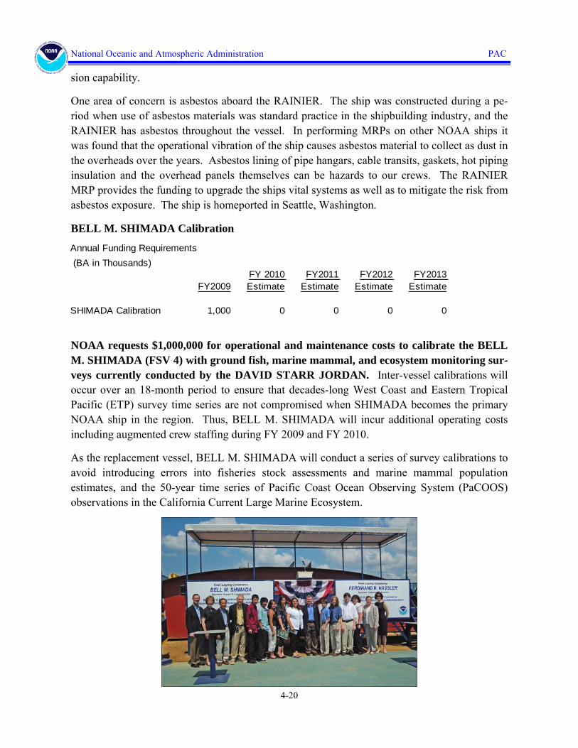
BELL M. SHIMADA Calibration
NOAA requests $1,000,000 for operational and maintenance costs to calibrate the BELL M. SHIMADA (FSV 4) with ground fish, marine mammal, and ecosystem monitoring sur-veys currently conducted by the DAVID STARR JORDAN. Inter-vessel calibrations will occur over an 18-month period to ensure that decades-long West Coast and Eastern Tropical Pacific (ETP) survey time series are not compromised when SHIMADA becomes the primary NOAA ship in the region. Thus, BELL M. SHIMADA will incur additional operating costs including augmented crew staffing during FY 2009 and FY 2010.
As the replacement vessel, BELL M. SHIMADA will conduct a series of survey calibrations to avoid introducing errors into fisheries stock assessments and marine mammal population estimates, and the 50-year time series of Pacific Coast Ocean Observing System (PaCOOS) observations in the California Current Large Marine Ecosystem.
Annual Funding Requirements (BA in Thousands)
FY2009FY 2010 Estimate
FY2011 Estimate
FY2012 Estimate
FY2013 Estimate
SHIMADA Calibration 1,000 0 0 0 0

4-21
National Oceanic and Atmospheric Administration PAC
With its extremely low acoustic, very quiet radiated noise signature, the vessel will perform hydroacoustic, ichthyoplankton, bottom and mid-water trawl surveys of fishery resources and marine mammal sighting surveys, while collecting physical and biological oceanographic data simultaneously during a single deployment. This combined capability is not available in the academic fleet or private sector. BELL M. SHIMADA will significantly improve the precision and accuracy of scientific assessments and will provide data to manage West Coast fish stocks, including Pacific whiting and rockfish, and to monitor marine mammals in the Equatorial Tropical Pacific (ETP). The ship will be homeported on the West Coast.

4-22
National Oceanic and Atmospheric Administration PAC
[This page intentionally left blank.]