Proceedings of the Workshop on Transboundary Pollution Reduction in River Basins and Coastal Areas
22
-
Upload
pemsea-partnerships-in-environmental-management-for-the-seas-of-east-asia -
Category
Documents
-
view
219 -
download
0
Transcript of Proceedings of the Workshop on Transboundary Pollution Reduction in River Basins and Coastal Areas
8/7/2019 Proceedings of the Workshop on Transboundary Pollution Reduction in River Basins and Coastal Areas
http://slidepdf.com/reader/full/proceedings-of-the-workshop-on-transboundary-pollution-reduction-in-river-basins 1/22
8/7/2019 Proceedings of the Workshop on Transboundary Pollution Reduction in River Basins and Coastal Areas
http://slidepdf.com/reader/full/proceedings-of-the-workshop-on-transboundary-pollution-reduction-in-river-basins 2/22
The East Asian Seas Congress 2009“Partnerships at Work: Local Implementation and Good Practices”
Manila, Philippines, 23-27 November 2009
Theme 6: Water Use and Supply Management Workshop 1: Transboundary Pollution Reductionin River Basins and Coastal Areas
25 November 2009
Co-Convening Agencies:Northwest Pacific Action Plan (NOWPAP) –
Pollution Monitoring Regional Activity Center (POMRAC)
Chair:Dr. Alexander Tkalin,Coordinator, NOWPAP of UNEP
Co-Chairs:Dr. Anatoly Kachur,
Director, POMRAC of NOWPAP
Mr. David Nemazie,Associate Vice President for External Affairs,
University of Maryland Center for Environmental Science, USA
Dr. Zhou Qiulin,Third Institute of Oceanography, State Oceanic Administration, PR China
BACKGROUND
Transboundary transport of pollutants through rivers is recognized as one of the maincauses of ecological problems in coastal and marine areas. Reduction of pollution inputs from
rivers is hence a prerequisite in addressing downstream pollution impacts in receiving coastaland marine waters.
Pollutants can be transported through rivers across jurisdictional boundaries within andacross countries, posing a challenge to the effectiveness of separate management effortsamong national and sub-national entities, and between river basins and coastal areas. Anintegrated approach in managing shared water systems and in addressing identified prioritiessuch as pollution, at various levels, is considered an imperative.
8/7/2019 Proceedings of the Workshop on Transboundary Pollution Reduction in River Basins and Coastal Areas
http://slidepdf.com/reader/full/proceedings-of-the-workshop-on-transboundary-pollution-reduction-in-river-basins 3/22
This workshop aimed to present and take lessons from case studies in the NorthwestPacific, East Asia and other regions on transboundary pollution reduction in rivers and coastalareas through integrated management approaches. It also aimed to share good practices andexperiences on integrating pollution reduction measures and tools in river basin managementamong established river basin management programs and areas that are starting the process.
TRANSBOUNDARY POLLUTION REDUCTION IN RIVER BASINS AND COASTAL AREAS FROM THE
NORTHWEST PACIFIC
Session 1 of the workshop focused on sharing case studies on transboundary pollutionreduction in river basins and coastal areas from the Northwest Pacific, including experiencesfrom the implementation of two UNDP/GEF projects in strategic river basins in thenortheastern Asia, and experiences in development and implementation of integrated coastalarea and river basin management (ICARM) in Russia, Republic of Korea, PR China andJapan. A model that can be used to distinguish sea areas where ICARM approach is stronglyrecommended from areas where influence of land-based point sources of nutrients is lessprobable was also presented.
International approaches to the transboundary pollution reduction through GEF“Amur River” and “TumenNet” Projects
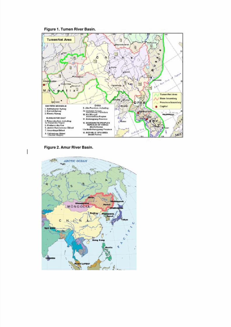
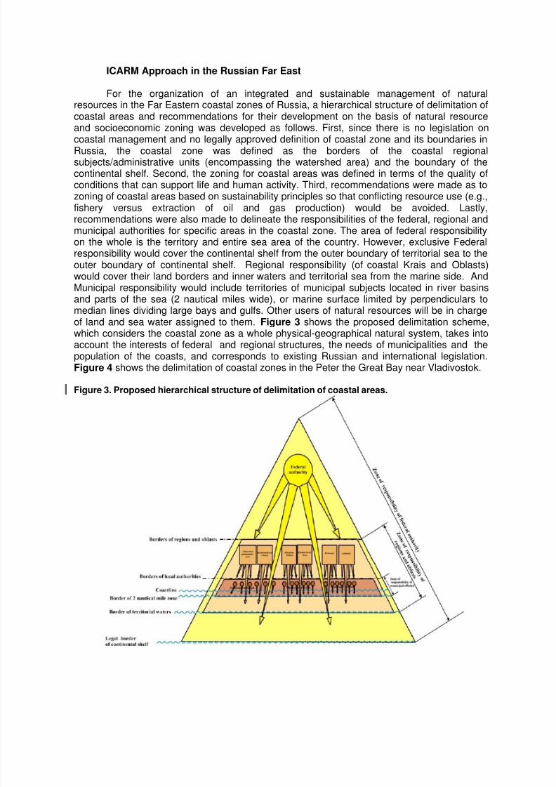
In the northeastern Asia, rapid economic development of PR China, Russia andRepublic of Korea are causing environmental and natural resource degradation in the Amurand Tumen River Basins (Figures 1 and 2). Three key problems confront the coastal areasand river basins: (1) habitat degradation; (2) pollution of transboundary ground and riverwaters; and (3) non-optimal utilization of resources. These are further compounded byinadequate institutional and management systems to address these problems in an integratedmanner. To address these problems, the UNDP/GEF projects “Tumen River Strategic ActionProgram” and “Integrated Management of the Amur/Heilong River Basin” aimed to develop an
overarching regional strategic action programme and establish an effective institutionalmechanism to address transboundary land-based threats to the aquatic environment of thebasins and their associated continental coastal areas. Taking into account the experiencesfrom these projects, the following courses of actions were recommended in order to ensurepollution reduction and habitat restoration in the river basins and coastal areas: (1) fosteringclose cooperation among neighboring countries in coordinating protection and use of naturalresources; (2) promoting development of coordinated economic policies; (3) developingcontingency plan in case of environmental emergences and joint ecological monitoring system;(4) facilitating more active role of civil society; and (5) establishment of internationalcommission to manage transboundary river basin and coastal areas similar to the MekongRiver Commission and the Yellow sea Commission.
8/7/2019 Proceedings of the Workshop on Transboundary Pollution Reduction in River Basins and Coastal Areas
http://slidepdf.com/reader/full/proceedings-of-the-workshop-on-transboundary-pollution-reduction-in-river-basins 4/22
Figure 1. Tumen River Basin.
Figure 2. Amur River Basin.
8/7/2019 Proceedings of the Workshop on Transboundary Pollution Reduction in River Basins and Coastal Areas
http://slidepdf.com/reader/full/proceedings-of-the-workshop-on-transboundary-pollution-reduction-in-river-basins 5/22
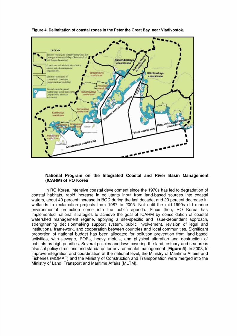
ICARM Approach in the Russian Far East
For the organization of an integrated and sustainable management of naturalresources in the Far Eastern coastal zones of Russia, a hierarchical structure of delimitation ofcoastal areas and recommendations for their development on the basis of natural resourceand socioeconomic zoning was developed as follows. First, since there is no legislation on
coastal management and no legally approved definition of coastal zone and its boundaries inRussia, the coastal zone was defined as the borders of the coastal regionalsubjects/administrative units (encompassing the watershed area) and the boundary of thecontinental shelf. Second, the zoning for coastal areas was defined in terms of the quality ofconditions that can support life and human activity. Third, recommendations were made as tozoning of coastal areas based on sustainability principles so that conflicting resource use (e.g.,fishery versus extraction of oil and gas production) would be avoided. Lastly,recommendations were also made to delineate the responsibilities of the federal, regional andmunicipal authorities for specific areas in the coastal zone. The area of federal responsibilityon the whole is the territory and entire sea area of the country. However, exclusive Federalresponsibility would cover the continental shelf from the outer boundary of territorial sea to theouter boundary of continental shelf. Regional responsibility (of coastal Krais and Oblasts)
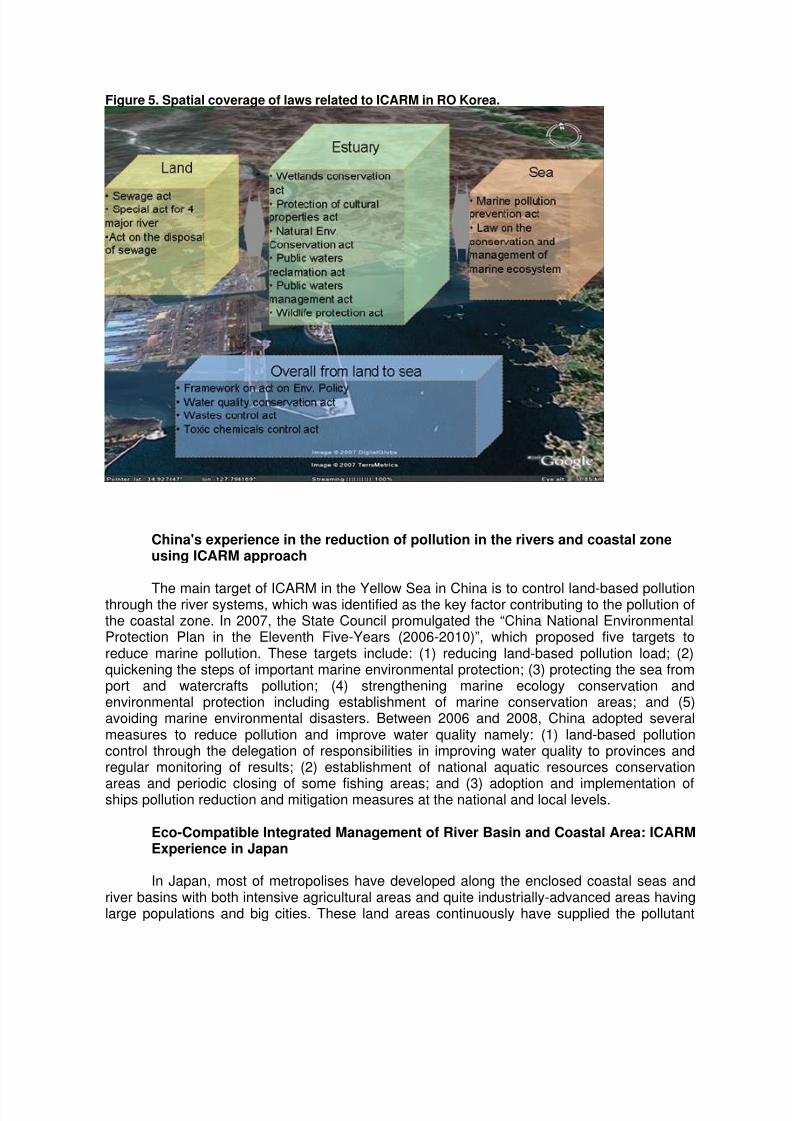
would cover their land borders and inner waters and territorial sea from the marine side. AndMunicipal responsibility would include territories of municipal subjects located in river basinsand parts of the sea (2 nautical miles wide), or marine surface limited by perpendiculars tomedian lines dividing large bays and gulfs. Other users of natural resources will be in chargeof land and sea water assigned to them. Figure 3 shows the proposed delimitation scheme,which considers the coastal zone as a whole physical-geographical natural system, takes intoaccount the interests of federal and regional structures, the needs of municipalities and thepopulation of the coasts, and corresponds to existing Russian and international legislation.Figure 4 shows the delimitation of coastal zones in the Peter the Great Bay near Vladivostok.
Figure 3. Proposed hierarchical structure of delimitation of coastal areas.
8/7/2019 Proceedings of the Workshop on Transboundary Pollution Reduction in River Basins and Coastal Areas
http://slidepdf.com/reader/full/proceedings-of-the-workshop-on-transboundary-pollution-reduction-in-river-basins 6/22
Figure 4. Delimitation of coastal zones in the Peter the Great Bay near Vladivostok.
National Program on the Integrated Coastal and River Basin Management(ICARM) of RO Korea
In RO Korea, intensive coastal development since the 1970s has led to degradation ofcoastal habitats, rapid increase in pollutants input from land-based sources into coastalwaters, about 40 percent increase in BOD during the last decade, and 20 percent decrease inwetlands to reclamation projects from 1987 to 2005. Not until the mid-1990s did marineenvironmental protection come into the public agenda. Since then, RO Korea hasimplemented national strategies to achieve the goal of ICARM by consolidation of coastalwatershed management regime, applying a site-specific and issue-dependent approach,strengthening decisionmaking support system, public involvement, revision of legal andinstitutional framework, and cooperation between countries and local communities. Significant
proportion of national budget has been allocated for pollution prevention from land-basedactivities, with sewage, POPs, heavy metals, and physical alteration and destruction ofhabitats as high priorities. Several policies and laws covering the land, estuary and sea areasalso set policy directions and standards for environmental management (Figure 5). In 2008, toimprove integration and coordination at the national level, the Ministry of Maritime Affairs andFisheries (MOMAF) and the Ministry of Construction and Transportation were merged into theMinistry of Land, Transport and Maritime Affairs (MLTM).
8/7/2019 Proceedings of the Workshop on Transboundary Pollution Reduction in River Basins and Coastal Areas
http://slidepdf.com/reader/full/proceedings-of-the-workshop-on-transboundary-pollution-reduction-in-river-basins 7/22
Figure 5. Spatial coverage of laws related to ICARM in RO Korea.
China's experience in the reduction of pollution in the rivers and coastal zoneusing ICARM approach
The main target of ICARM in the Yellow Sea in China is to control land-based pollutionthrough the river systems, which was identified as the key factor contributing to the pollution ofthe coastal zone. In 2007, the State Council promulgated the “China National EnvironmentalProtection Plan in the Eleventh Five-Years (2006-2010)”, which proposed five targets toreduce marine pollution. These targets include: (1) reducing land-based pollution load; (2)quickening the steps of important marine environmental protection; (3) protecting the sea fromport and watercrafts pollution; (4) strengthening marine ecology conservation andenvironmental protection including establishment of marine conservation areas; and (5)avoiding marine environmental disasters. Between 2006 and 2008, China adopted severalmeasures to reduce pollution and improve water quality namely: (1) land-based pollutioncontrol through the delegation of responsibilities in improving water quality to provinces andregular monitoring of results; (2) establishment of national aquatic resources conservation
areas and periodic closing of some fishing areas; and (3) adoption and implementation ofships pollution reduction and mitigation measures at the national and local levels.
Eco-Compatible Integrated Management of River Basin and Coastal Area: ICARMExperience in Japan
In Japan, most of metropolises have developed along the enclosed coastal seas andriver basins with both intensive agricultural areas and quite industrially-advanced areas havinglarge populations and big cities. These land areas continuously have supplied the pollutant

8/7/2019 Proceedings of the Workshop on Transboundary Pollution Reduction in River Basins and Coastal Areas
http://slidepdf.com/reader/full/proceedings-of-the-workshop-on-transboundary-pollution-reduction-in-river-basins 8/22
loads, and sometimes resulted in water pollution and degradation of marine ecosystems.Hence, the Japanese Government has been aggressively implementing environmentalprotection countermeasures directed at controlling and reducing land-based pollution at sourcein the river basin, through the Total Pollution Load Control System (TPLCS). The purpose ofTPLCS is to reduce the pollutant loads entering into the enclosed seas, especially specifiedwater bodies of Tokyo Bay, Ise Bay and Seto Inland Sea. Every five years, the Minister of the
Environment formulates a Basic Policy for Total Pollutant Load Control System (BPTPLCS).The governor of each prefecture makes a Total Pollutant Load Control Plan to achieve thepollutant load reduction target according to the BPTPLCS. Such plan generally consists ofconcrete measures to reduce pollutants from households, industries, and agricultural lands.These measures significantly reduced the COD and TN load in Tokyo Bay, Ise Bay and SetoInland Sea between 1979 and 2009 (Figure 6). However, further environmental improvementfrom the forest to the sea areas was targeted, for which ICARM is a comprehensive approach.In 2007, a strategic environmental policy was formulated and the Basic Act on Ocean Policywas enacted, which emphasized the integrated management of coastal area and river basin.For the development of ICARM in Ise Bay, an assessment framework for eco-compatibleintegrated management of river basin and coastal area was applied, which consists of threetool boxes to evaluate natural and man-made flux network (e.g., water, sediment, pollutant
load), evaluate ecosystem service for each categorized landscape which forms the river basin,coastal area and bay, and for integrated evaluation (Figure 7).
Figure 6. Reduction in pollutant load in Tokyo Bay, Ise Bay and Seto Inland Sea between 1979and 2009.
Others
Industrial
Discharges
Household
Discharges
Industrial
Discharges
Others
C O D
L o a d
( t o n / D a y )
Remarks: ’09 values = Ta rget Amount
Tokyo Bay Ise Bay
Seto Inland SeaTrend of COD Load
’79
T - N
L o a d
( t o n / D a y ) Trend of T-N Load
Tokyo BayIse Bay
Seto Inland Sea
’79 ’84 ’89 ’94 ’99 ’04 ‘09 ’79 ’84 ’89 ’94 ’99 ’04 ‘09 ’79 ’84 ’89 ’94 ’99 ’04 ‘09
’79 ’84 ’89 ’94 ’99 ’04 ‘09 79 ’84 ’89 ’94 ’99 ’04 ‘09 ’79 ’84 ’89 ’94 ’99 ’04 ‘09
1000
800
600
400
200
800
600
400
200
Effective measures for water environment of enclosed sea
HouseholdDischarges

8/7/2019 Proceedings of the Workshop on Transboundary Pollution Reduction in River Basins and Coastal Areas
http://slidepdf.com/reader/full/proceedings-of-the-workshop-on-transboundary-pollution-reduction-in-river-basins 9/22
Figure 7. Schematic diagram of eco-compatible assessment.
Tool Box 1 Flux network analyzing model : land and coastTool Box 2 Ecosystem service modeling : Categorized landscape
Tool Box 3 Integrated eco-compatibility assessment model
Precipitation
Tool Box 3
Tool Box 2
GeographyLand-uses
Artificial flux Tool Box 1
Flux network φ
Ecological service ES
Flux
change
Δφ
Integrated assessment
of Eco-compatibility
Categorized
landscape
Choice of Scenario
Significance of the River Input of Nutrients in relation to Coastal Eutrophication:Spatial Zoning examples from the Northwest Pacific
The assessment of the sea area where land-based sources determine thecharacteristics and ecological problems is a prerequisite necessary for the proper spatialzoning and success of the ICARM approach. In the NOWPAP region, which combines
countries with very different natural and socioeconomical conditions, there is a need forindicators that would allow zoning of the vast coastal sea areas according to the influence ofland-based sources. River runoff is the main land-based source of chemical substancesincluding nutrients to the coastal areas, and excessive input of nutrients is believed to be amain reason for eutrophication of coastal waters.
The high natural and socioeconomic non-uniformity within the NOWPAP region makesit necessary to normalize the riverine fluxes of nutrients influencing on the sea areas for properzoning in support of ICARM. In place of the traditional area-normalized discharge (specificdischarge, Q/S), which is a characteristic of watersheds and does not reflect comprehensivelythe influence of river input on the coastal waters, shore length normalization (coastal specificdischarge) is proposed as a proxy assessment of the influence of river runoff (or other land-
based point sources) on the coastal sea areas at the regional and subregional scale. Coastalspecific discharge (QL) is equal to the ratio between the volume of discharge and the length ofthe shoreline of material delivery (QL [tons/year.km] = Q [tons/year]/L [km]). The length ofshore between the boundaries of catchment areas was taken as the shoreline length (L). Thenormalized input allows to distinguish in a regional scale, the areas where eutrophication dueto land-based sources of nitrogen are possible (Figure 8). The coastal specific discharge,however, is a “first step,” rather rough estimate, because it does not account the specificoceanographic features of concrete coastal sea areas. It should also be noted that low valueof coastal specific discharge does not mean that ecological problems due to land-based

8/7/2019 Proceedings of the Workshop on Transboundary Pollution Reduction in River Basins and Coastal Areas
http://slidepdf.com/reader/full/proceedings-of-the-workshop-on-transboundary-pollution-reduction-in-river-basins 10/22
sources are absent, but just that these problems probably do not exceed the local scale. Inintegrated management, the assessment of land-based fluxes is interesting not in itself, but asa reason of the changes or deterioration of the adjacent marine ecosystems. Hence, as afurther step, a simple model was presented for the evaluation of the area of coastal waters —where the existing level of plankton production or eutrophication could be provided by theobserved riverine flux of nitrogen — is proposed as a proxy estimation or indicator of the
influence of river runoff on the adjacent coastal waters (‘river dependent sea area’). The biggerthis area means the stronger influence of land-based sources of nutrients in eutrophication incoastal waters. The main disadvantage of this indicator is an ignoring of oceanographic and/orbiological features of specified localities. This indicator, however, allows looking at and tocompare the situation at the regional and subregional level within big sea areas. Bothsimplified models (‘coastal specific discharge’ and ‘river dependent sea area’) allowdistinguishing the sea areas where ICARM approach is strongly recommended from the areaswhere influence of the land-based point sources of nutrients is less probable.
Figure 8. The normalized input allow to distinguish in a regional scale, the areas whereeutrophication events due to land-based sources of nitrogen are possible (Amur
Liman, Bohai Sea) or, on the contrary, are very rare and limited (Russian Primorye,southwest of Honsyu Island).
TN input is rather variable: from 2 to 500 tons/year.km
Normalized input allow to distinguish in regional scale the areas whereeutrophication due to land based sources of nitrogen are possible (Amur Liman,Bohai Sea) or contrary, are very rare and limited (Russian Primorye, southwestof Honsyu Is.)
TRANSBOUNDARY POLLUTION REDUCTION IN RIVER BASINS AND COASTAL AREAS FROM THE
EAST ASIAN REGION
Session 2 of the workshop focused on case studies of transboundary pollutionreduction in river basins and coastal areas from the East Asian region, including Jakarta Bayand Ciliwung River in Indonesia, Pasig River and Manila Bay in the Philippines, Selangor andKlang river systems and the coastal waters of Port Klang in Malaysia, Jiulongjiang River basinand Xiamen Bay in PR China, and the Singapore River and Kallang Basin in Singapore. A
8/7/2019 Proceedings of the Workshop on Transboundary Pollution Reduction in River Basins and Coastal Areas
http://slidepdf.com/reader/full/proceedings-of-the-workshop-on-transboundary-pollution-reduction-in-river-basins 11/22
model that can estimate pollutant load from various sources even with limited data was alsopresented.
Integrated management of Jakarta Bay and Ciliwung River
Jakarta, the capital city of Republic of Indonesia, has been the economic development
center of the country and the resulting urbanization has created environmental as well associal problems. The city also has 10 million people night-time population and 12 millionpeople day-time population due to commuting workers, and the Greater Jakarta area has atotal population of around 25 million people. The city’s geographical condition is characterizedby a low-lying region, with 13 river systems coming from neighboring administrative regions ofBanten and West Java Provinces flowing to Jakarta Bay in the northern part of the city. One ofthe rivers flowing into the bay is the Ciliwung River, which in the past used to be aneconomically-important transportation route but is now functioning mainly as a flood controlcanal. Ciliwung River flows through 72 sub-districts with many areas along the river banksoccupied by informal settlers. Large volumes of solid waste and sedimentation due to landerosion upstream have resulted to a decrease in the water flow of the river. In addition,industrial waste, agricultural waste, livestock manure, and market waste flow into the river
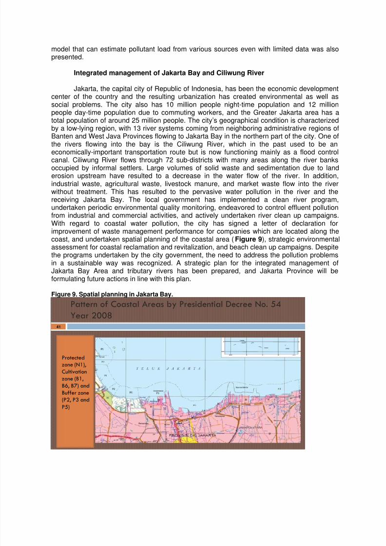
without treatment. This has resulted to the pervasive water pollution in the river and thereceiving Jakarta Bay. The local government has implemented a clean river program,undertaken periodic environmental quality monitoring, endeavored to control effluent pollutionfrom industrial and commercial activities, and actively undertaken river clean up campaigns.With regard to coastal water pollution, the city has signed a letter of declaration forimprovement of waste management performance for companies which are located along thecoast, and undertaken spatial planning of the coastal area (Figure 9), strategic environmentalassessment for coastal reclamation and revitalization, and beach clean up campaigns. Despitethe programs undertaken by the city government, the need to address the pollution problemsin a sustainable way was recognized. A strategic plan for the integrated management ofJakarta Bay Area and tributary rivers has been prepared, and Jakarta Province will beformulating future actions in line with this plan.
Figure 9. Spatial planning in Jakarta Bay.
Pattern of Coastal Areas by Presidential Decree No. 54
Year 2008
Protected
zone (N1),
Cultivation
zone (B1,
B6, B7) and
Buffer zone
(P2, P3 and
P5)
41
8/7/2019 Proceedings of the Workshop on Transboundary Pollution Reduction in River Basins and Coastal Areas
http://slidepdf.com/reader/full/proceedings-of-the-workshop-on-transboundary-pollution-reduction-in-river-basins 12/22
Reducing Pollution in the Pasig River: Targets, Strategies, Good Practices,Achievements and Challenges
The Pasig River is one of the major rivers and most important natural waterways in thePhilippines. Located at the heart of the nation’s capital, the 27-km river serves as the only linkbetween Manila Bay and Laguna de Bai. The Pasig River also has four major and 43 minor
tributaries which are directly and continuously discharging polluted water into it. Thesetributaries, including the Laguna de Bai had significantly caused the degradation of the waterquality of the Pasig River and Manila Bay. Recognizing its role in the sociocultural formationand economic progress of the Philippines and the preservation of Manila Bay, the Philippinegovernment made the rehabilitation of Pasig River a flagship program for the environment. In1999, the Pasig River Rehabilitation Commission was created through an Executive Order,with the main objective to upgrade the water quality of Pasig River to Class C level, with waterquality that is fit for fishery, secondary recreation and water supply for manufacturingprocesses (after treatment). The Commission has set 12 targets to:
1. Eliminate offensive odor;2. Reduce BOD load from 330 tons/day to 200 tons/day;
3. Reduce solid waste;4. Increase and control the flow of water;5. Reduce flooding;6. Enforce zoning ordinances by respective local government units (LGUs);7. Remove sunken vessels;8. Develop linear parks;9. Relocate informal settlers;10. Establish water transport service;11. Bioremediation/aeration and filtration; and12. Phytoremediation.
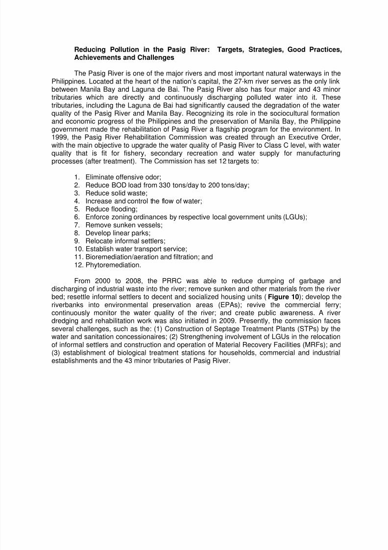
From 2000 to 2008, the PRRC was able to reduce dumping of garbage and
discharging of industrial waste into the river; remove sunken and other materials from the riverbed; resettle informal settlers to decent and socialized housing units (Figure 10); develop theriverbanks into environmental preservation areas (EPAs); revive the commercial ferry;continuously monitor the water quality of the river; and create public awareness. A riverdredging and rehabilitation work was also initiated in 2009. Presently, the commission facesseveral challenges, such as the: (1) Construction of Septage Treatment Plants (STPs) by thewater and sanitation concessionaires; (2) Strengthening involvement of LGUs in the relocationof informal settlers and construction and operation of Material Recovery Facilities (MRFs); and(3) establishment of biological treatment stations for households, commercial and industrialestablishments and the 43 minor tributaries of Pasig River.
8/7/2019 Proceedings of the Workshop on Transboundary Pollution Reduction in River Basins and Coastal Areas
http://slidepdf.com/reader/full/proceedings-of-the-workshop-on-transboundary-pollution-reduction-in-river-basins 13/22
Figure 10. Community facilities in PRRC relocation sites.
Major Programs 2001 – 2008 ADB: PAREMAR-SDP
Community Facilities on all PRRC relocation sites
School Buildings
Learning Center
Day Care Center
Recreation Area
Pollution reduction in Selangor and Klang River System
In the Selangor and Klang River in Malaysia, pollution is one of the largest threatsapart from dams and the destruction of highland catchments. The sources of pollution includedomestic and industrial sewage, effluent from livestock farms, manufacturing and agro-basedindustries, suspended solids from mining, earthworks, and road construction, logging and
clearing of forest. To ensure that the water resources and environment are in manageable andsustainable conditions, the Selangor Waters Management Authority — a one-stop agency forthe management of water resources, river basin, ground water, coastal water and other waterbodies — was set up by law in 1999. In the past, the approach was to treat river basin andcoastal management separately.
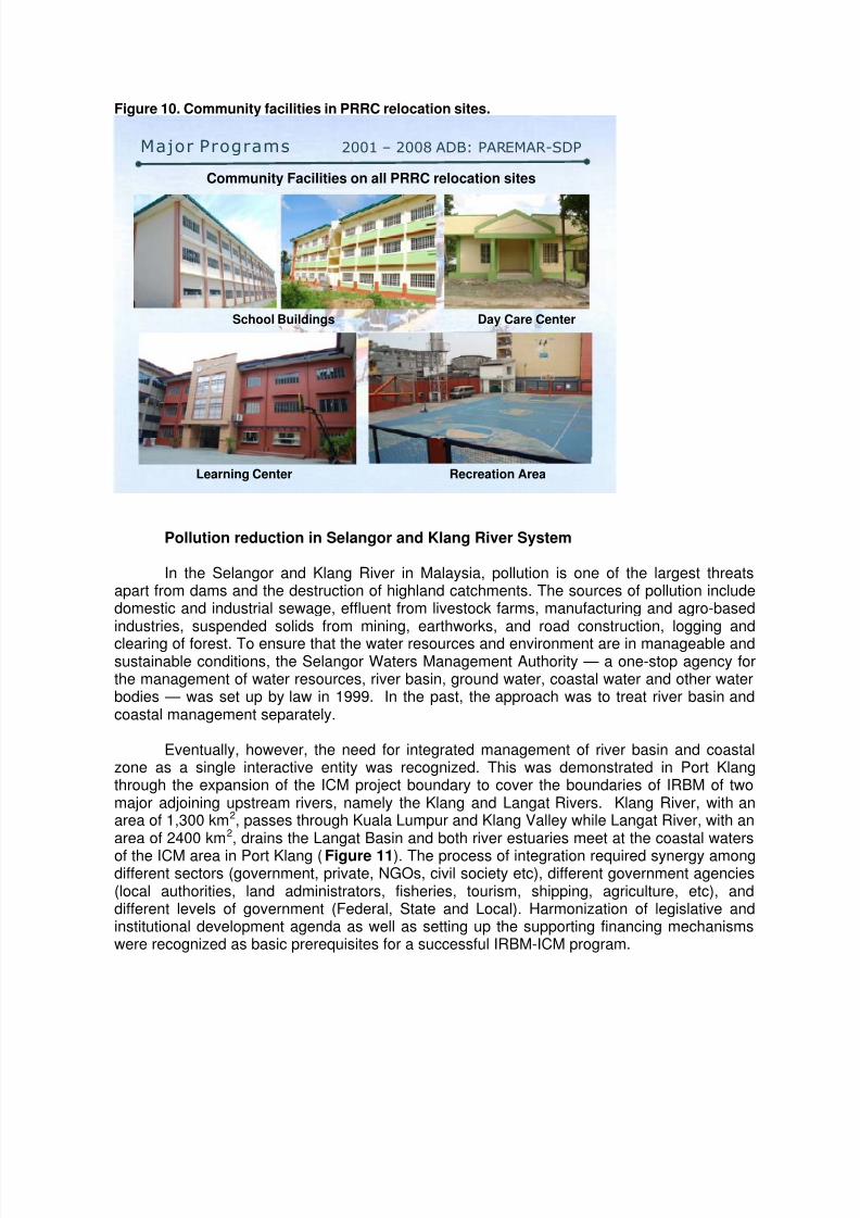
Eventually, however, the need for integrated management of river basin and coastalzone as a single interactive entity was recognized. This was demonstrated in Port Klangthrough the expansion of the ICM project boundary to cover the boundaries of IRBM of twomajor adjoining upstream rivers, namely the Klang and Langat Rivers. Klang River, with anarea of 1,300 km2, passes through Kuala Lumpur and Klang Valley while Langat River, with anarea of 2400 km2, drains the Langat Basin and both river estuaries meet at the coastal waters
of the ICM area in Port Klang (Figure 11). The process of integration required synergy amongdifferent sectors (government, private, NGOs, civil society etc), different government agencies(local authorities, land administrators, fisheries, tourism, shipping, agriculture, etc), anddifferent levels of government (Federal, State and Local). Harmonization of legislative andinstitutional development agenda as well as setting up the supporting financing mechanismswere recognized as basic prerequisites for a successful IRBM-ICM program.
8/7/2019 Proceedings of the Workshop on Transboundary Pollution Reduction in River Basins and Coastal Areas
http://slidepdf.com/reader/full/proceedings-of-the-workshop-on-transboundary-pollution-reduction-in-river-basins 14/22
Figure 11. The IRBC-ICM demonstration area covering the coastal waters of Port Klang andKlang and Langat River Basins.
THE ICM‐IRBM PILOT DEMONSTRATION SITE :
• ICM Port Klang (joint program by PEMSEA‐
IMO‐UNDP‐GEF/Selangor State Government) –
was selected for this study.
• Integrating the IRBM‐ICM project boundary
resulted in an expanded boundary that covers
boundaries of IRBM of two major adjoining
upstream rivers, namely the Klang and Langat
Rivers.
• Klang River (area=1300 km2) passes through
Kuala Lumpur and Klang Valley whilst Langat
River (area=2400km2) drains the Langat Basin
and both river estuaries meet at the coastal
waters of ICM Port Klang.
Control of Land-Based Pollution in Singapore and Experience in Cleaning up theSingapore River
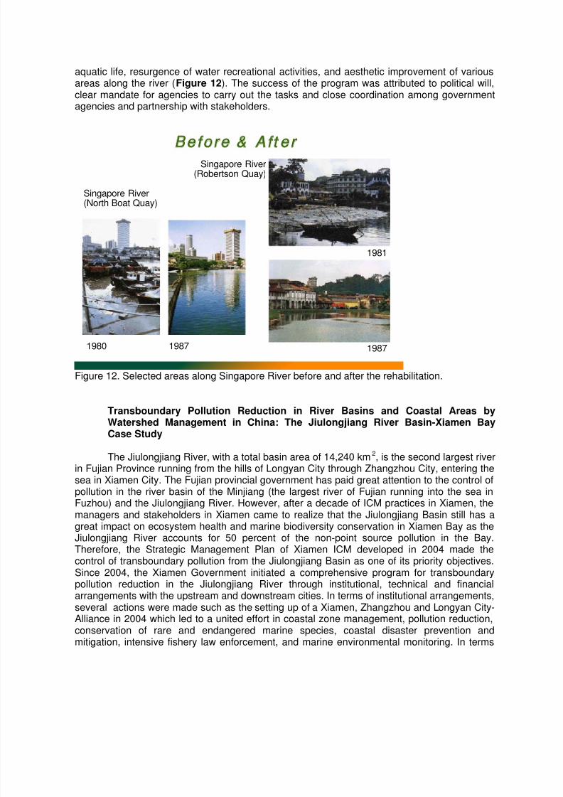
In Singapore, major marine sources of pollution include ship-borne pollution and land-
based pollution. Land-based pollutants originate from municipal, agricultural and industrialactivities. Many studies have indicated that land-based sources are the major contributors ofthe marine pollution. Being a city-state, the main sources of land-based pollution in Singaporeare domestic wastewater, both sewage and industrial effluent. There are also somecommercial farms in the suburban areas, which generate pollutive wastes, which if notproperly managed, will also pollute inland and coastal waters. With proper planning control,provision of environmental infrastructure and pollution control facilities, stringent enforcementof pollution control legislation and an effective monitoring programme, Singapore hascontrolled the land-based pollution sources effectively and kept the inland and coastal watersclean and healthy. A big challenge that Singapore faced in the late 1970s is the seriouspollution of the Singapore River such that in 1977, then Prime Minister Lee Kuan Yew issued achallenge to have the Singapore River cleaned up in ten years. This resulted into a 10-year
master plan aimed at cleaning up Singapore River and Kallang Basin. The goals were toremove sources of pollution and to ensure quality that can support fish and other aquatic lifeand water recreational activities. An interagency committee was led by the Ministry ofEnvironment which adopted action programs meant to: (1) identify sources of pollution andmeasures to remove them; (2) upgrade environmental infrastructure and construct newinfrastructure; (3) review existing institutional structure and legislation to strengthenenvironmental pollution control; (4) resettle industries and squatters along river banks; (5)develop action programs and implement them; and (6) river rehabilitation and beautification.After just 10 years, the quality of river has improved dramatically as indicated by the return of
8/7/2019 Proceedings of the Workshop on Transboundary Pollution Reduction in River Basins and Coastal Areas
http://slidepdf.com/reader/full/proceedings-of-the-workshop-on-transboundary-pollution-reduction-in-river-basins 15/22
aquatic life, resurgence of water recreational activities, and aesthetic improvement of variousareas along the river (Figure 12). The success of the program was attributed to political will,clear mandate for agencies to carry out the tasks and close coordination among governmentagencies and partnership with stakeholders.
B e f o r e & A f t e r
Singapore River(North Boat Quay)
19871980
Singapore River(Robertson Quay)
1981
1987
Figure 12. Selected areas along Singapore River before and after the rehabilitation.
Transboundary Pollution Reduction in River Basins and Coastal Areas by
Watershed Management in China: The Jiulongjiang River Basin-Xiamen BayCase Study
The Jiulongjiang River, with a total basin area of 14,240 km2, is the second largest riverin Fujian Province running from the hills of Longyan City through Zhangzhou City, entering thesea in Xiamen City. The Fujian provincial government has paid great attention to the control ofpollution in the river basin of the Minjiang (the largest river of Fujian running into the sea inFuzhou) and the Jiulongjiang River. However, after a decade of ICM practices in Xiamen, themanagers and stakeholders in Xiamen came to realize that the Jiulongjiang Basin still has agreat impact on ecosystem health and marine biodiversity conservation in Xiamen Bay as theJiulongjiang River accounts for 50 percent of the non-point source pollution in the Bay.Therefore, the Strategic Management Plan of Xiamen ICM developed in 2004 made the
control of transboundary pollution from the Jiulongjiang Basin as one of its priority objectives.Since 2004, the Xiamen Government initiated a comprehensive program for transboundarypollution reduction in the Jiulongjiang River through institutional, technical and financialarrangements with the upstream and downstream cities. In terms of institutional arrangements,several actions were made such as the setting up of a Xiamen, Zhangzhou and Longyan City-Alliance in 2004 which led to a united effort in coastal zone management, pollution reduction,conservation of rare and endangered marine species, coastal disaster prevention andmitigation, intensive fishery law enforcement, and marine environmental monitoring. In terms
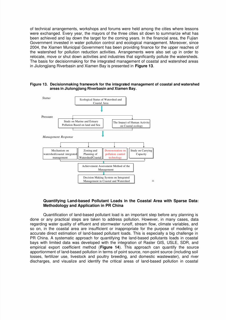
8/7/2019 Proceedings of the Workshop on Transboundary Pollution Reduction in River Basins and Coastal Areas
http://slidepdf.com/reader/full/proceedings-of-the-workshop-on-transboundary-pollution-reduction-in-river-basins 16/22
of technical arrangements, workshops and forums were held among the cities where lessonswere exchanged. Every year, the mayors of the three cities sit down to summarize what hasbeen achieved and lay down the target for the coming years. In the financial area, the FujianGovernment invested in water pollution control and ecological management. Moreover, since2004, the Xiamen Municipal Government has been providing finance for the upper reaches ofthe watershed for pollution reduction activities. Arrangements were also set up in order to
relocate, move or shut down activities and industries that significantly pollute the watersheds.The basis for decisionmaking for the integrated management of coastal and watershed areasin Jiulongjiang Riverbasin and Xiamen Bay is presented in Figure 13.
Figure 13. Decisionmaking framework for the integrated management of coastal and watershedareas in Jiulongjiang Riverbasin and Xiamen Bay.
11
Ecological Status of Watershed and
Coastal Area
Ecological Status of Watershed and
Coastal Area
Status
Study on Marine and Estuary
Pollution Based on land and Sea
Study on Marine and Estuary
Pollution Based on land and Sea
Mechanism on
watershed/coastal integrated
management
Mechanism on
watershed/coastal integrated
management
Pressure
Management Response
Demonstration on
pollution control
technology
Demonstration on
pollution control
technology
Achievement Assessment Method of the
Management
Achievement Assessment Method of the
Management
Zoning and
Planning of
Watershed/Coastal
Zoning and
Planning of
Watershed/Coastal
The Impact of Human Activity
on Coastal ecology
The Impact of Human Activity
on Coastal ecology
Decision Making System on Integrated
Management in Coastal and Watershed
Decision Making System on Integrated
Management in Coastal and Watershed
Study on Carrying
Capacity
Study on Carrying
Capacity
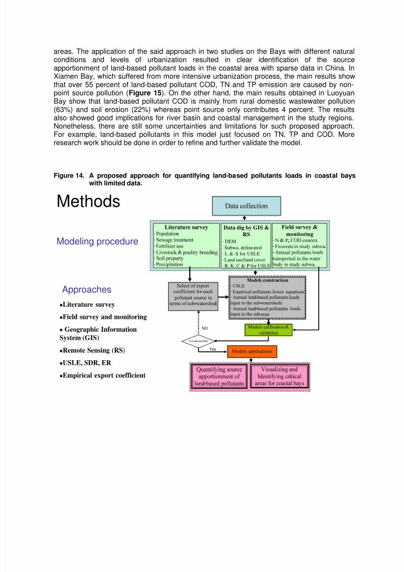
Quantifying Land-based Pollutant Loads in the Coastal Area with Sparse Data:Methodology and Application in PR China
Quantification of land-based pollutant load is an important step before any planning isdone or any practical steps are taken to address pollution. However, in many cases, data
regarding water quality of effluent and stormwater runoff, stream flow, climate variables, andso on, in the coastal area are insufficient or inappropriate for the purpose of modeling oraccurate direct estimation of land-based pollutant loads. This is especially a big challenge inPR China. A systematic approach for quantifying the land-based pollutants loads in coastalbays with limited data was developed with the integration of Raster GIS, USLE, SDR, andempirical export coefficient method (Figure 14). This approach can quantify the sourceapportionment of land-based pollution in terms of point source, non-point source (including soillosses, fertilizer use, livestock and poultry breeding, and domestic wastewater), and riverdischarges, and visualize and identify the critical areas of land-based pollution in coastal
8/7/2019 Proceedings of the Workshop on Transboundary Pollution Reduction in River Basins and Coastal Areas
http://slidepdf.com/reader/full/proceedings-of-the-workshop-on-transboundary-pollution-reduction-in-river-basins 17/22
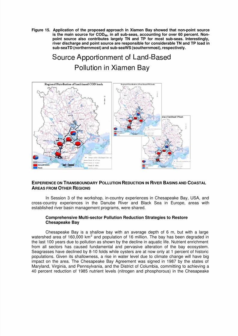
areas. The application of the said approach in two studies on the Bays with different naturalconditions and levels of urbanization resulted in clear identification of the sourceapportionment of land-based pollutant loads in the coastal area with sparse data in China. InXiamen Bay, which suffered from more intensive urbanization process, the main results showthat over 55 percent of land-based pollutant COD, TN and TP emission are caused by non-point source pollution (Figure 15). On the other hand, the main results obtained in Luoyuan
Bay show that land-based pollutant COD is mainly from rural domestic wastewater pollution(63%) and soil erosion (22%) whereas point source only contributes 4 percent. The resultsalso showed good implications for river basin and coastal management in the study regions.Nonetheless, there are still some uncertainties and limitations for such proposed approach.For example, land-based pollutants in this model just focused on TN, TP and COD. Moreresearch work should be done in order to refine and further validate the model.
Figure 14. A proposed approach for quantifying land-based pollutants loads in coastal bayswith limited data.
Data dig by GIS &
RS
· DEM
· Subwa. delineated
· L & S for USLE
· Land use/land cover
· R, K, C & P for USLE
NO
Yes
Methods
Literature survey
Field survey and monitoring
Geographic Information
System (GIS)
Remote Sensing (RS)
USLE, SDR, ER
Empirical export coefficient
Approaches
Modeling procedure
8/7/2019 Proceedings of the Workshop on Transboundary Pollution Reduction in River Basins and Coastal Areas
http://slidepdf.com/reader/full/proceedings-of-the-workshop-on-transboundary-pollution-reduction-in-river-basins 18/22
Figure 15. Application of the proposed approach in Xiamen Bay showed that non-point sourceis the main source for CODMn in all sub-seas, accounting for over 60 percent. Non-point source also contributes largely TN and TP for most sub-seas. Interestingly,river discharge and point source are responsible for considerable TN and TP load insub-seaTD (northernmost) and sub-seaWS (southernmost), respectively.
ource pport onment o an - asePollution in Xiamen Bay
EXPERIENCE ON TRANSBOUNDARY POLLUTION REDUCTION IN RIVER BASINS AND COASTAL
AREAS FROM OTHER REGIONS
In Session 3 of the workshop, in-country experiences in Chesapeake Bay, USA, andcross-country experiences in the Danube River and Black Sea in Europe, areas withestablished river basin management programs, were shared.
Comprehensive Multi-sector Pollution Reduction Strategies to RestoreChesapeake Bay
Chesapeake Bay is a shallow bay with an average depth of 6 m, but with a large
watershed area of 160,000 km2 and population of 16 million. The bay has been degraded inthe last 100 years due to pollution as shown by the decline in aquatic life. Nutrient enrichmentfrom all sectors has caused fundamental and pervasive alteration of the bay ecosystem.Seagrasses have declined by 8-10 folds while oysters are at now only at 1 percent of historicpopulations. Given its shallowness, a rise in water level due to climate change will have bigimpact on the area. The Chesapeake Bay Agreement was signed in 1987 by the states ofMaryland, Virginia, and Pennsylvania, and the District of Columbia, committing to achieving a40 percent reduction of 1985 nutrient levels (nitrogen and phosphorous) in the Chesapeake
8/7/2019 Proceedings of the Workshop on Transboundary Pollution Reduction in River Basins and Coastal Areas
http://slidepdf.com/reader/full/proceedings-of-the-workshop-on-transboundary-pollution-reduction-in-river-basins 19/22
Bay by the year 2000 and capping nutrient levels thereafter. Although the goal was not met,significant nutrient reductions were achieved. Various laws and measures applied to reducenutrient pollution, include:
1. Critical Areas Law (1984) concerning protection of shorelines (revised in 2008);2. Phosphate Laundry Detergent Ban of 1988 to reduce phosphorous loads;3. Water Quality Improvement Act of 1998 addressing nutrient management on farms;
4. Bay Restoration Fund of 2005 primarily to support waste water treatment plantupgrades and also cover crops and septic upgrades;
5. Water Resources Element of Comprehensive Plans of 2006 to ensure water andsewer capacity available for growth; and
6. the Chesapeake Bay 2010 Trust Fund to support reduction of non-point sources ofpollution.
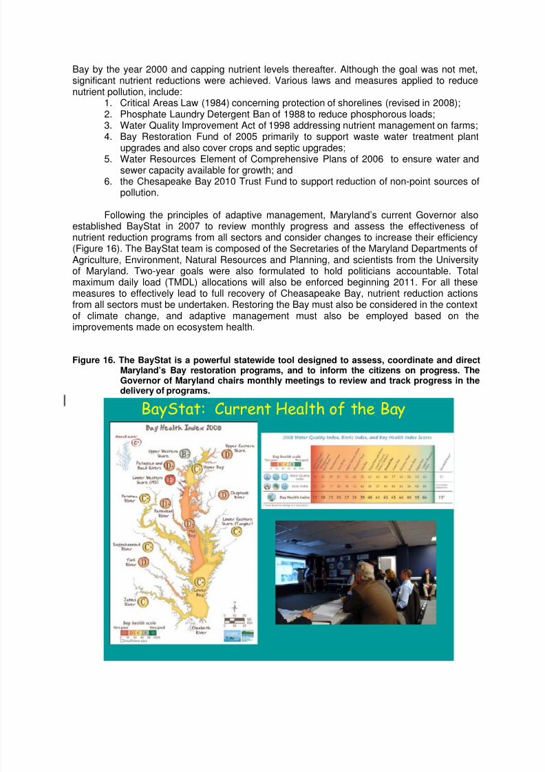
Following the principles of adaptive management, Maryland’s current Governor alsoestablished BayStat in 2007 to review monthly progress and assess the effectiveness ofnutrient reduction programs from all sectors and consider changes to increase their efficiency(Figure 16). The BayStat team is composed of the Secretaries of the Maryland Departments ofAgriculture, Environment, Natural Resources and Planning, and scientists from the University
of Maryland. Two-year goals were also formulated to hold politicians accountable. Totalmaximum daily load (TMDL) allocations will also be enforced beginning 2011. For all thesemeasures to effectively lead to full recovery of Cheasapeake Bay, nutrient reduction actionsfrom all sectors must be undertaken. Restoring the Bay must also be considered in the contextof climate change, and adaptive management must also be employed based on theimprovements made on ecosystem health.
Figure 16. The BayStat is a powerful statewide tool designed to assess, coordinate and directMaryland’s Bay restoration programs, and to inform the citizens on progress. TheGovernor of Maryland chairs monthly meetings to review and track progress in thedelivery of programs.
BayStat: Current Health of the Bay
8/7/2019 Proceedings of the Workshop on Transboundary Pollution Reduction in River Basins and Coastal Areas
http://slidepdf.com/reader/full/proceedings-of-the-workshop-on-transboundary-pollution-reduction-in-river-basins 20/22
Danube/Black Sea Strategic Partnership for Nutrient Pollution Reduction
To address pollution from excess nutrients, and the associated eutrophication in thelower Danube and the Black Sea, the GEF Strategic Partnership on nutrient reduction waslaunched in 2001 in the GEF International Waters focal area with an initial commitment ofUS$95 million in GEF grants. The initiative was coordinated by The World Bank, UNDP,
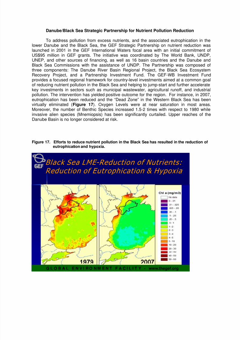
UNEP, and other sources of financing, as well as 16 basin countries and the Danube andBlack Sea Commissions with the assistance of UNDP. The Partnership was composed ofthree components: The Danube River Basin Regional Project, the Black Sea EcosystemRecovery Project, and a Partnership Investment Fund. The GEF-WB Investment Fundprovides a focused regional framework for country-level investments aimed at a common goalof reducing nutrient pollution in the Black Sea and helping to jump-start and further acceleratekey investments in sectors such as municipal wastewater, agricultural runoff, and industrialpollution. The intervention has yielded positive outcome for the region. For instance, in 2007,eutrophication has been reduced and the “Dead Zone” in the Western Black Sea has beenvirtually eliminated (Figure 17). Oxygen Levels were at near saturation in most areas.Moreover, the number of Benthic Species increased 1.5-2 times with respect to 1980 whileinvasive alien species (Mnemiopsis) has been significantly curtailed. Upper reaches of the
Danube Basin is no longer considered at risk.
Figure 17. Efforts to reduce nutrient pollution in the Black Sea has resulted in the reduction ofeutrophication and hypoxia.
G L O B A L E N V I R O N M E N T F A C I L I T Y - www.thegef.org
Black Sea LME Black Sea LME - - Reduction of Nutrients: Reduction of Nutrients:
Reduction of Eutrophication & Hypoxia Reduction of Eutrophication & Hypoxia

8/7/2019 Proceedings of the Workshop on Transboundary Pollution Reduction in River Basins and Coastal Areas
http://slidepdf.com/reader/full/proceedings-of-the-workshop-on-transboundary-pollution-reduction-in-river-basins 21/22
OPEN FORUM
The Open Forum that followed the presentations highlighted the challenges intransboundary pollution reduction and the need for the following:
1. Political will, commitment and leadership to address pollution problems.
2. Interagency and multisectoral cooperation in the management of the river basinand coastal areas, including water management authorities, ocean managementagencies, environmental protection agencies, the academe, the civil society andother concerned sectors are involved in the management of the bay. It is alsoimportant to enhance coordination and develop areas of collaboration amongrelated programs and initiatives, and to improve the level of cooperation in realactions.
3. Appropriate legislation, regulatory framework and strong enforcement.
4. Establishment of environmental infrastructure, considering cost-effective
technologies.
5. Long-term investments in environmental infrastructure, with strong institutionalsupport. For transboundary pollution reduction, financial agreement, in addition topolitical agreement, is also important since participating countries or local
jurisdictions may have different capacities.
6. Establishment of institutional arrangements, including appropriate bodies tooversee transboundary pollution reduction, such as the international commissionsfor the Mekong River Commission, Yellow Sea and Danube-Black Sea for cross-country pollution reduction. National or subnational commissions and alliancesbetween levels of government and other stakeholders can also be forged for in-
country pollution reduction.
7. Good coordination in monitoring, quality assurance and quality control andstandardization of data.
8. Documentation of good practices and lessons, sharing of success stories andsharing of benefits.
RECOMMENDATIONS
Through the analysis of best practices from the Northwest Pacific, East Asia,
Europe and North America, workshop participants agreed that the following actionsare deemed necessary for transboundary pollution reduction in river basins andcoastal areas:
• Close cooperation of neighboring countries or local governments in economicpolicies, including coordinated use of natural resources, environment protectionand ensuring sustainable development of river basins and coastal areas.
8/7/2019 Proceedings of the Workshop on Transboundary Pollution Reduction in River Basins and Coastal Areas
http://slidepdf.com/reader/full/proceedings-of-the-workshop-on-transboundary-pollution-reduction-in-river-basins 22/22
• Political leadership; legislation and enforcement; financial resources; politicalagreement (commitment); bringing together academics and decisionmakers.
• National laws and regulations aiming at coordinated economic, investment andsocial policies related to environmental protection and sustainable development(including tourism-related regulations; wastewater treatment; environmental
monitoring and compliance).
• More active role of civil society in natural resources and wildlife conservation.
• Establishment of international/intergovernmental commissions to managetransboundary river basins and coastal areas, such as Mekong River Commission;Yellow Sea Commission; etc. across countries, or similar arrangements acrosslocal governments.
• Establishment of joint monitoring systems (including water quality standards andcriteria) for transboundary river basins and coastal areas.