Proceedings of the AYIA Annual Conference 2007
168
-
Upload
brian-dolan -
Category
Documents
-
view
217 -
download
1
description
Conference Proceedings
Transcript of Proceedings of the AYIA Annual Conference 2007


ii
Proceedings of
The Association of Young Irish
Archaeologists
Annual Conference 2007
Hosted by
University College Dublin 23rd – 25th February 2007
Edited by Brian Dolan, Amy McQuillan,
Emmett O’Keeffe and Kim Rice

iii
Proceedings of The Association of Young Irish Archaeologists Annual Conference 2007. Published in 2008 by The Association of Young Irish Archaeologists School of Archaeology, University College Dublin, Belfield, Dublin 4, Ireland. © The individual authors 2008 ISBN: 0–9503627–2–7 978–0–9503627–2–4 Cover design: Emmet O’Keeffe Copy–editing: Brian Dolan, Amy McQuillan, Emmett O’Keeffe and Kim Rice Layout: Brian Dolan Printed by Digiprint.ie, Unit B1, KCR Industrial Estate, Kimmage, Dublin 12, Ireland

iv
Contents Contents iv Foreword/Acknowledgements v The Movement of Prehistoric People in the Nephin Mountain Landscape, Co Mayo 1 Patrick Walsh The Irish Sheela–Na–Gig – Once Scorned But Now Revived and Celebrated 11 Niall Kenny Imitatio Romae: High Status Recumbent Cross–Slabs, High–Crosses and the Organisation of the Early Monastic Landscape of Glendalough 31 Lorcan Harney A Tale of Two Saints: Some Perceptions of Identity in Early Medieval Europe 47 Maureen Doyle Norse Houses in Ireland and Western Britain AD 800 – 1100: A Social Archaeology of Dwellings, Ethnicity and Culture 57 Rebecca Boyd A Reassessment of MidBronze Age Cave Burials from Ogof yr Esgyrn in the Dan yr Ogof Caves, South Wales 69 Kare McManama–Kearin No Bones About It, A Skeleton Can Look Too Young For Its Age: A New Direction In The Estimation of Age–At–Death 93 Ian Magee A General Overview of Pathological Lesions Noted During the Osteoarchaeological Analysis of the First Two Hundred Skeletons from the Medieval Cemetery Site at Ballyhanna, Co. Donegal 107 Catriona McKenzie The Landscape of Mottes in Co. Louth: Topography, Location and Function 119 Sara Nylund Approaches to Battlefield Archaeology in Ireland: A Case Study of the Siege and Battle of Kinsale AD 1601 133 Paul O’Keeffe Cultural Landscapes in South Western Alaska – Varieties of Interpretation 147 Don O’Meara Constitution of the AYIA 159

v
Foreword/Acknowledgements The Association of Young Irish Archaeologists Conference of 2007 was a great success. The high quality, diverse and interesting array of presentations was matched only by the enthusiasm and support of those who attended. The conference was hosted by University College Dublin and was attended by students of the National University of Ireland, Galway; University College Cork; Queens University Belfast; Sligo Institute of Technology and delegates working in the state and commercial sectors. The AYIA provides a forum for young Irish archaeologists to present and discuss their research among a group of peers in a friendly environment. The publication of the proceedings allows the dissemination of this research to a wider audience. The conference began on Friday evening with a welcome address from Professor Muiris O’Sullivan, head of the UCD School of Archaeology, followed by the inaugural lecture by Dr. Aidan O’Sullivan entitled ‘Ireland’s western islands and re–imagining a Gaelic Irish Nation’. The conference on Saturday was organised chronologically and thematically into four sessions (reflected in this publication); each of which were concluded with an opportunity for debate and questions. The Sunday field trip comprised a visit to the site of the Battle of the Boyne, Co. Louth, led by Dr. Conor Brady, followed by a tour of the passage tomb complex at Knowth, Co. Meath by Professor George Eogan. The conference, and this publication, would not have been possible without the generous support of our sponsors (National Monuments Section, DOEHLG; Headland Archaeology; ACS Ltd.; Valerie J. Keeley Ltd.; the NRA; the Royal Society of Antiquaries; Dublin City Council), the speakers and innumerable others who contributed in a variety of ways. We would particularly like to thank the UCD School of Archaeology, for their support, Professor Muiris O’Sullivan for the welcome address and Dr. Aidan O’Sullivan for the inaugural lecture. Thanks also to Professor Gabriel Cooney and Conor McDermott for their involvement. We would like to acknowledge the efforts of the Archaeology Society, UCD, for assistance with the running of the conference. We also extend our thanks to Professor George Eogan and Dr. Conor Brady for the memorable Sunday fieldtrip and the OPW for facilitating our visit to Knowth; to Archaeology Ireland for supplying prizes for the pub quiz and last but not least, the members of the Association of Young Irish Archaeologists for attending and maintaining the enthusiasm and engagement of the previous years conference. The combination of high quality research, vigorous debate and fascinating site visits, which constitutes the AYIA annual conference, creates the perfect forum for young Irish archaeologists to present their work, learn and share ideas among a group of peers. The successful publication of this, and past proceedings is a valuable contribution to the dissemination of knowledge, providing an accessible first–step on the ladder of academic publication to those at the beginning of their careers.
The AYIA Committee 2007*
Brian Dolan Amy McQuillan
Emmett O’Keeffe Kim Rice
* [email protected]; [email protected]; [email protected]; [email protected]

vi
With thanks to:
UCD School of Archaeology

Patrick Walsh
1
The Movement of Prehistoric People in the Nephin Mountain Landscape, Co Mayo Patrick Walsh*
The central aim of this paper is to discuss how monuments, particularly, barrows and standing stones may have fulfilled different roles within the prehistoric landscape around Nephin Mountain, Co. Mayo. The topography of the local landscape consists of mountain peaks and ranges, undulating fertile lowlands, marginal land and lakes. The positions of mountain lakes and rivers may have led the movement of people along defined natural routeways, aided/reinforced/marked by the built monuments. It is suggested that these monuments indicated routeways, of not only ‘domestic character’ between farmsteads and various resources, but also fulfilled a role in maintaining social and economic contacts over long distances within this part of Mayo. This theory of monuments marking route ways was tested in the field and a summary of the results follow.
The Study Area Nephin Mountain is the second highest mountain in Connaught, rising on the west side of Lough Conn. The Nephin Mountain range extends from Lough Conn to the east of the study area and to Achill Island in the west, where Croaghaun Mountain ends in a sheer vertical drop into the Atlantic Ocean. The mountain is composed of impervious quartzite with marginal boggy land at its base rising to exposed barren rock at its peak. The Nephin range acts as a natural boundary dividing the territories of south and north Mayo and is located along the westerly point of a line of court tombs that extend from east of the country to the west. The Nephin locality is well known for its lake setting, with the larger lakes Lough Conn and Lough Cullin to the east, and the smaller lakes of Lough Levally and Bofeenaun to the South. Within this landscape, there are stretches of lakeshore, winding rivers, tracts of virgin and cut away bog and areas of fertile lowlands and uplands.
Barrows Barrows illustrate a very interesting pattern in this landscape around Nephin. There are different types of barrows; round or ring barrows are the most common type, which are sub divided up into five classes: bowl, bell, disc, and saucer and pond barrows. The barrows in the study area are all ring barrows. It is not easy to date barrows; Doody explains how some barrow complexes may date from as early as the Neolithic through to the Iron Age (Doody 1992). Individual barrows could be long lived, providing the focus for successive burials over several centuries. The ring barrow is usually low, with an artificially raised mound, surrounded by a ditch and bank (e.g. Figure 2, Plate 1). As explained, this is the predominant type of barrow within the Nephin landscape. Barrows must have had enormous significance for this type of monument to persist over such a long period. The rituals and beliefs associated with their creation may have been more important than their function for burial. This can be said by the fact that some barrows that were excavated were found without any trace of a burial, as was the case of several barrows in Lissard, Co Limerick (Ó Ríordáin 1936). Others were used either for the burial of one or more people, cremated or as inhumation and often further burials were added at a later stage. Barrow 8, of a group of 11 barrows at Carrowjames, Co Mayo contained as many as 25 cremations (Raftery 1940–41). This accumulative effect of burial * Department of Archaeology, National University of Ireland, Galway

The Movement of Prehistoric People in the Nephin Mountain Landscape, Co. Mayo
2
Figure 1—GIS display of the archaeological monuments in the Nephin Landscape.
Figure 2—Plan of ring barrow in Kilmurray townland, north of Nephin.
Plate 1—View of barrow in Castlehill with Nephin in the background looking south.
Figure 3—The distribution of barrows in Co Mayo.

Patrick Walsh
3
from different periods further monumentalise the landscape already rich in structures built to celebrate the sacred (Pollard and Reynolds 2002). Ring barrows often occur in clusters and are sometimes conjoined. Rathdooneybeg, Co Sligo includes a ring barrow built onto an earlier bowl barrow, forming a figure of eight monument. Charcoal from a funeral pyre and the primary burial was used to date an Iron Age sequence (Mount 1995). Conjoined barrows are also found in Co Meath, e.g. Slieve Breagh and the Hill of Tara (Newman 1993), where a number of small earlier barrows have been organically incorporated into larger structures. This inclusion indicates a continuation of ritual activity or reclaiming previous ceremonial locations, with respect for their past. The burials include men, women and children of all ages, sometimes accompanied by grave goods, which included pottery, glass beads, bronze razors, bronze bracelets, and pins. Grave goods were more often personal items, like razors, rather than status symbols, like weapons. This is no reflection on the importance of the people buried in them. A small cylindrical bronze box, decorated with iron and red enamel found in a ring ditch in Ballydavis, Co Laois, has similarity with one found in a chariot grave in Yorkshire, which are considered as being rare or associated with high status burial (Waddell 1998). It leads to the suggestion that a small cremation in a modest ring ditch might nonetheless be a high status burial. Bradley discusses that deposits were buried in natural mounds and relates the origin of the barrows to natural mounds or humps in the ground. Or possibly these geological features become a focus for offerings because they were mistaken for burial mounds. Ornament hoards in Denmark were associated with both natural mounds and funerary mounds (Bradley 1998). Every area has its own particular landscape features, which played a role in where and how the barrows were placed. In some areas a preference for naturally high and prominent locations can be detected, or in less hidden low lying platforms. In North Galway fourteen barrows are found in low–lying grassland, while seventeen occupy high places. A small cluster of three barrows in Rathdooney Beg, Co Sligo includes two bowl barrows and one ring barrow (Mount 1995). It belongs to a group of 45 barrows in the barony of Corraun, Co Sligo, surveyed in the early 1990s which consists of ring barrows, bowl barrows and embanked barrow mounds and a stepped barrow (Farrelly and Keane 2002). Another group in Co Sligo is recorded east of Lough Gara; c.30 barrows of different types (Fredengren 2002; Augustine 2003). There is a high concentration of barrows at the Hill of Tara, Co Meath and Rathcroghaun, Co Roscommon can be seen as an indication of the special, indeed sacred character of the area (Waddell 1998). Clusters occur in most places and linear alignments are noted at least in Rath Jordan, Co limerick and Tullymore, Co Donegal (Ó Ríordáin 1947). The land they inhabit is similar to that of the lowlands around Nephin: good quality farmland, with undulating glacial ridges. The barrows, which are the cemeteries to the dead, can be described as a “pushing away” of the deceased from the main settlements within the community. The barrows therefore tend to be located away from the main areas where the habitation sites might have been and favoured the positioning closer to the lake or watercourse areas (Cooney and Grogan 1994). Tilley would argue the highly visible barrows attracted other barrows through time, providing the traveller with visual pathways and nodal points (Tilley 1994). He has used this approach of “intervisibility” between the long barrows in Cranborne Chase, which is near the causewayed enclosure in Hambledon Hill. The barrows taken for this paper are

The Movement of Prehistoric People in the Nephin Mountain Landscape, Co. Mayo
4
simpler ring barrows than those barrows at Cranborne, there are however comparisons which can be made. Like the barrows in the study area, Tilley’s examples are spread out over a long distance and can be seen from up to nine kilometres away. They appear to be related to local topographical features as opposed to other monuments and intervisibility appeared to be a prime concern of the builders (Tilley 1994). There have been excavations within the wider Nephin area, a cemetery mound or barrow at Corrower, southeast of Ballina, consisted of a low circular mound some 13m in diameter and was found to contain nine graves (Waddell 1998). At Carrowjames in Co Mayo a cluster of ring, barrows were excavated by Raftery in the 1940s. Carrowjames is situated within the wider scope of the specific study area. The ring barrows excavated were mostly low, c. 0.5m in height, with some ditches surrounding them. They were clustered more tightly together, so they seem to only function as burial mounds rather than markers of any passage through a landscape (Raftery 1940–41). The survey of the Ballyhoura hills project undertaken by Martin Doody includes a survey with a range of site types, which include barrows and associated earthworks. As mentioned the barrow complexes can date from as early as the Neolithic to as late as the Iron Age (Doody 1992). The burial mounds may have once showed a linear pattern, but over such a long period and due to continual use there was an addition of more mounds. Therefore, if there were any linear trend they would have become more nucleated with time. There were further excavations carried out by Daly and Grogan of four barrows in Mitchelstowndown West in County Limerick. These examples have a linear pattern but are almost touching each other over a very short distance, so it is also unlikely that these barrows create any avenue for travelling through the landscape (Daly and Grogan 1993). At Tara, there is a sequence or plan in the placing of the barrows. Newman would argue that there was a hierarchical system involved in the placement of the monuments. The more important burial mounds were placed close to the centre of the hill while the lower status sites were pushed away and became satellites to the sanctified centre of Tara (Newman 1993). These outlier sites may have been used to delimit the periphery of the sacred ground. This trend can also be observed within the Salisbury Plain landscape, which contains the densest and largest groups of round barrows in Britain. They all seem to be in the limits of visibility from Stonehenge as to create an ‘envelope of visibility’. There seems to be no Bronze Age remains within this envelope only those lining the limits of the further reaches of the Stonehenge complex. This could be interpreted as liminal zones between the landscape of the living and the dead (Parker Pearson and Ramilisonina 1998). The barrows within the study area could be acting as a liminal line also, enclosing Lough Conn to the east. It is difficult to say whether the barrows create the limits of a settlement or sacred site when there is no evidence for such a place.
Barrows in the Nephin Landscape There is reasonably strong evidence to suggest that the barrows do form an alignment that could lead people across the Nephin landscape. Within the study area, there are nine barrows, from Knockfarnaght in the south running through to Castlehill, Kilmurray and on to Carrowcloghagh just short of the Deel River where there is a cluster of four barrows (Figure 3). On the other side of the river, there is another barrow at Lecarrow. These barrows show a linear trend, and cover a distance of approximately five kilometres. This concept of “intervisibility” would seem to have also been a concern for the barrow builders in this part of Mayo. Interestingly, there is a lack of barrows outside this linear stretch of

Patrick Walsh
5
Figure 4—Digital Terrain Model of the line of Barrows in the Nephin landscape looking north.
Plate 3—Overview of furnace pits in Doonbreedia.
Plate 4—Possible standing stone at Massbrook.

The Movement of Prehistoric People in the Nephin Mountain Landscape, Co. Mayo
6
monuments, there are only two located at Errew along the banks of Lough Conn. There is an obvious desire therefore, for the barrow builders to be located along this linear route. The line of barrows is also aligned along a relatively narrow dry ridge. The people obviously favoured the dry ground, away from areas that are liable to flooding, presumably for easy movement along a naturally defined routeway. This ridge is particularly noticeable from Kilmurry to the north of Nephin to Carrowcloghagh south of the Deel River. The question therefore is where these barrows are leading. One is that the barrows lead to a fording point at the Deel River (Figure 4). In between the cluster of barrows in Carrowcloghagh to the south of the Deel River and the barrow to the north at Lecarrow, there is a fording point indicated. The barrows, therefore, may have acted as signposts along the route around the base of Nephin and on up through the fording point in the Deel river. By passing through this fording point, there is a symbolic movement across the river and on into North Mayo. North Mayo would have been a well–known area in prehistory. We can make this assumption from rich archaeological landscape around Céide. Barrows overlooking rivers have been highlighted in the Salisbury Plains where the monuments are close to river courses. The cemetery at Overton is an example where the barrows are built in association with earlier monuments and the river courses. Cleal argues that overlooking other monuments was a major concern for the barrow mounds in Avebury. The palisade enclosures all seemed to have formed foci for cemeteries or later barrow mounds. The Bronze Age builders of the round barrows remained more than ever anxious to place mounds in clear visible relationship to monuments (Cleal 2005). From studying the terrain model of the landscape and the barrows, it looks as if the barrows are creating a liminal line around Lough Conn. However, from field walking the lake is not visible from the barrows, and therefore the lake may have played no role in the placement of these monuments at their locations. This is further evidence, that the line of barrows may have a role in leading the prehistoric people through this landscape. During the period when the barrows were being constructed, there was seemingly a search for wealth and resources. This search for wealth may have been another factor in the distribution of the barrows, and it seems to provide the motive for the widespread travelling of these peoples. There is an economic incentive for the promise of new agricultural land, metal or other commodities, and we know from recent excavations within the study area, that the production of metal was a concern for the people. Excavations in Doonbreedia uncovered furnace pits, which could be of an Iron Age date. The presence of a large quantity of slag would suggest that the furnace pits (Plate 3) could have been of a contemporary date with the construction of the barrows (Murphy forthcoming).
Standing Stones Standing stones comprise of a single stone set upright into the ground and can vary in height from one to seven meters. They can be found all over the country but are especially common in the southwest where around six hundred examples are known. The function of standing stones is a mystery though several theories have been put forward including territorial boundary markers and land markers (Waddell 1998). In some cases, excavation has revealed cist burials in association with these monuments, adding weight to the theory that standing stones could be grave markers (O’Kelly 1989). The dating of standing stones is problematic. Some standing stones have been found in association with cist burials like the one in Furness, where the cist contained the remains of at least two adults, which were accompanied by sherds of pottery an archers wrist guard and worked flint (Herity and

Patrick Walsh
7
Eogan 1996). Therefore they are generally associated with the Bronze Age, but their construction and uses may extend from the Late Neolithic into the Late Bronze Age (Corlett 2001). Standing stones usually occur in isolation. However, some may form part of alignments, which are generally defined as three or more standing stones forming a linear arrangement. There is an example of this in Killadangan near Croagh Patrick to the west of the study area (Morahan 2000). It is interesting that their association is with Bronze Age burials, which appears to support the theory of them being for ceremonial and for ritual use (Corlett 2001).
Figure 8—Digital Terrain Model of the standing stones in the Nephin landscape looking north towards
Carrowkilleen the site of the court tomb.
Figure 6—Map of Mayo with the areas of interest highlighted Aghamore, Nephin and Céide.

The Movement of Prehistoric People in the Nephin Mountain Landscape, Co. Mayo
8
Bradley discussed how standing stones were positioned in relation to local topographical features, and to one another, in order to form short alignments across the landscape. He emphasized the importance of avenues and alignments of monuments over distances, which may have coerced the movement of the people along certain routes (Bradley 1993). Muir suggested that standing stones were located on high points, indicating a desire for them to be seen from long distances (Muir 1999). There is also a theory that the standing stones within the West Mayo landscape might indicate markers along a routeway. Tóchar Phádraig is one such example, which is a pilgrim route to Croagh Patrick. The standing stones could have marked the route for an earlier pagan pilgrim road (Corlett 2001). There are ethnographic parallels with standing stones in Betsileo, the highland region in Madagascar, where standing stones are primarily the markers for the dead and traditionally commemorate a man whose body has not returned to his ancestral tomb. They are also used to mark the boundaries of different groups or territories. Another interesting role of the standing stones in this region is that they may have been erected to mark important events like winning or loosing a battle (Parker Pearson and Ramilisonina 1998).
Standing Stones in the Nephin Landscape The evidence from the Nephin landscape suggests that the standing stones are aligned along a possible prehistoric route (Figure 8), although the evidence is not as convincing as that of the barrows. However, similarly to the barrows, the standing stones north of Nephin appear to run in a north – south line. During fieldwork, a possible standing stone was discovered in Massbrook townland, to the north of a modern walking trail “The Foxford way” (Plate 4). The stone is situated at the entrance into a mountain pass and forms part of an alignment with other standing stones around Nephin. As you move north and follow the line of barrows and standing stones, they seem to mirror each other until they reach a crossroads at Sranalaghta North and Sranalaghta South. Here there is a cluster of sites, including one of the barrows in the neighbouring townland at Kilmurray Beg. It would seem that once the traveller passes through Sranalaghta they can follow the line of barrows which will lead them to the fording point along the River Deel, or follow the course of the standing stones which aligns a possible route to Carrowkilleen. Carrowkilleen is one of the largest court tombs in Mayo and must have been a desired location to visit in prehistory. The tomb here has had later chambers added to its structure, which indicates the continued evolving nature of the site through the periods in prehistory (Keane 1990). The continued use of this court tomb could indicate that the tomb still played a role into the Bronze Age, which means it could have been of a contemporary date with the erection of the standing stones. The court tomb would have been used primarily for burials, and perhaps too this tomb at Carrowkilleen was also a gathering or meeting point for the travelling prehistoric people. There is still evidence of a large amount of mound or cairn material on the site at Carrowkilleen and this mound would have been seen from great distances. If the standing stones do outline a routeway then this tomb could have been a desired location to visit.
Connecting the Landscape The location of a possible standing stone at the entrance of the mountain pass through the Massbrook mountain range could have indicated the routeway for the prehistoric traveller coming from the more populated regions from south Mayo. The people could have moved through the less populated region of the Nephin landscape using the barrows and the standing stones as possible markers along their route and ending up in the more populated regions of north Mayo. We know central and south Mayo must have had higher

Patrick Walsh
9
populations of people from the density of prehistoric sites and monuments in townlands like Aghamore and Turlough. North Mayo too is rich in archaeological remains.
Conclusion It has been the purpose of this paper to present an interpretation of the role the archaeological monuments specific to the Nephin landscape played in prehistory. By using GIS applications, maps and photography it is hoped that more clarity has been brought to the monument’s possible roles and functions within the Nephin landscape. The visible nature of the archaeological features means they must have had both a symbolic and practical significance during prehistory. The barrows may have their origins back to as early as the Neolithic period, and could still have been active into the Late Iron Age period. The standing stones too, would have fulfilled a function within this period. Therefore, there may have been continuity between these monument types. The court tomb at Carrowkilleen would have typically been dated to the Neolithic period, but this huge monument may have been a significant landscape feature throughout the historic period. If these were indeed prehistoric routeways, they were probably used to maintain social contacts or for long distance travel, for trade and attendance at seasonal or annual gatherings perhaps to the known places in North Mayo. The barrows seem to have a higher function than merely being earthen mounds covering the dead. They may symbolise a sacred route leading to a water supply that was a crucial resource for the existence of the prehistoric people. At Carrowcloghagh, the cluster of monuments could represent the fording point along the river. This fording point over the Deel River was more than just a bridging point; it marked a symbolic causeway where the traveller may have crossed from one territory into another.
Bibliography Augustine, M. 2003. Barrows in the landscape of Cúil Irra, Co Sligo. Unpublished MA Thesis,
National University of Ireland Galway. Bradley, R. 1993. Altering the Earth: the Origins of monuments in Britain and continental Europe.
The Rhine Lectures 1991–1992 Society of Antiquaries Scotland Monograph Series 8, Edinburgh.
Bradley, R. 1998. The Significance of Monuments: on the shaping of human experience in Neolithic and Bronze Age Europe. London: Routledge.
Caulfield, S. 1983. The Neolithic Settlement of North Connacht. In T. Reeves–Smyth and F. Hammond (eds). Landscape archaeology in Ireland. BAR: British Series 116, 195–215. Oxford.
Cleal, R. 2005. ‘The small compass of a grave’? Early Bronze Age burial in and around Avebury and the Marlborough Downs. In G. Brown, D. Field and D. McOmish (eds.), The Avebury Landscape, Aspects of the Field Archaeology of the Marlborough Downs, 115–32. Oxford: Oxbow.
Corlett, C. 2001. The Antiquities of West Mayo. Bray: Wordwell. Cooney, G and Grogan, E. 1994. Irish prehistory a social perceptive. Bray: Wordwell. Daly, A. and Grogan, E. 1992. Excavation of four barrows in Mitchelstowndown West, Knocklong,
County Limerick. Discovery Programme Reports 1, 44–60. Dublin: Royal Irish Academy. Doody, M. 1992. Ballyhoura Hills Project: Interim report. Discovery Programme Reports 1, 20–30.
Dublin: Royal Irish Academy. Farrelly, J. and Keane, M. 2002. New barrow types identified in County Sligo. In M.A. Timoney
(ed), A Celebration of Sligo: First Essays for Sligo Field Club, 97–101. Sligo: Sligo Field Club.
Fredengren, C. 2002. Crannogs: a study of people’s interaction with lakes, with particular reference to Lough Gara in the north–west of Ireland. Bray: Wordwell.
Herity, M and Eogan, G. 1996. Ireland in Prehistory. London and New York: Routledge.
The Movement of Prehistoric People in the Nephin Mountain Landscape, Co. Mayo
10
Keane, M. 1990. The Deel Basin: A historical survey. Ballina: Western People Printing. Morahan, L. 2000. Croagh Patrick Co Mayo: Archaeology, landscape and people. The Croagh
Patrick Archaeological Committee, Westport, Co Mayo. Mount, C. 1995. Excavations at Rathdooney Beg, Co Sligo. Emania 13, 79–87. Muir, R. 1999. Approaches to Landscape. London: MacMillion Press. Murphy, D. (Forthcoming). Furnace pits in Doonbredia, Archaeological excavation report for ACS
Ltd. Newman, C, 1993. Tara Project: The Tara survey – Interim report. Discovery Programme Reports
2, 62–67. Dublin: Royal Irish Academy. O’ Kelly, M.J. 1989. Early Ireland: an introduction to Irish Prehistory. Cambridge University
Press. Ó Ríordáin, S.P. 1936. Excavations at Lissard, Co Limerick and other sites in the locality, Journal
of Royal Society of Antiquaries, Series 7, Vol. 6, 173–185. Ó Ríordáin, S.P. 1947. Excavations of a Barrow at Rathjordan Co Limerick, Journal of the Cork
Historical and Archaeological Society 52, 1–4. Parker Pearson, M. and Ramilisonina. 1998. Stonehenge for the ancestors: the stones pass on the
message. Antiquity 72, 308–26. Pollard, J. and Reynolds, A. 2002. Avebury. The Biography of a Landscape. Stroud: Tempus. Raftery, J. 1940–41 The Tumulus Cemetery of Carrowjames, Co. Mayo; Part II – Carrowjames II,
Journal of the Galway Archaeological and Historical Society 19, 16–85. Tilley, C. 1994. A Phenomenology of Landscape. Oxford: Berg. Waddell, J. 1998. The Prehistoric Archaeology of Ireland. Galway: Galway University Press.

Niall Kenny
11
The Irish Sheela–Na–Gig – Once Scorned But Now Revived and Celebrated Niall Kenny*
There has been a recent revival in academic and public interest in the sheela–na–gig exhibitionist figures. In recent times, the sheela–na–gig has had a creative and artistic influence on many poets (including Seamus Heaney and Michael Longley), painters, musicians and craftsmen. Academics (archaeologists and art historians) are now no longer reluctant to engage in the discussion and study of the enigmatic sheela–na–gig. However, there has been very little exploration or any real interpretation of the archaeological context of sheela–na–gigs and this can partly be explained by the fact that the nature of the remaining evidence is very problematic. This paper proposes to outline the various problems associated with the current corpus of Irish sheela–na–gigs and also to briefly discuss some trends arising from a recent analysis of the figures. Lastly, the original archaeological context of one such figure shall be examined briefly; illustrating the potential archaeology has to offer the study of sheela–na–gigs. The purpose of this study of the Irish sheela–na–gigs is not to supersede or negate previous work, but to add another dimension to the study of sheelas; to reassert an archaeology of the monuments.
Introduction Firstly, I will briefly describe what sheela–na–gigs are and then I shall outline the general context and distribution of the figures as well as the main theories of origin and function, finally moving on to the main premise of the article. Sheela–na–gigs are figurative stone carvings of naked women exposing and overtly displaying their genitals. Typically, the female is depicted as standing or squatting with her legs and arms widely splayed. On many of the figures, one or sometimes even two of the hands are shown pointing to or touching the genital area, drawing deliberate attention and focus to the pudenda (Figure 1). Seamus Heaney (1998, 234) describes this attribute quite well in his poem about the ‘Sheelagh na Gig at Kilpeck’ (one such figure in England); ‘her hands holding herself, are like hands in an old barn holding a bag open’. Heaney (1998, 234–5) also describes this figure as ‘twig–boned’ and ‘saddle–sexed’ with ‘ring–fort eyes’ and a flat incised nose. If we were to write a poem about every individual sheela–na–gig we would soon realise that no two sheela–na–gigs are identical; each carving has its own unique attributes and idiosyncrasies. In saying this, there are many common characteristics of the sheela–na–gig carvings and these often include at least one or a combination of the following: a disproportionately large head (often bald) compared to the rest of the body; prominent bulging eyes; large ears; a wedge–shaped nose; a contorted ghastly mouth, sometimes displaying teeth or a protruding tongue; a thin scraggy neck; large shoulders; widely splayed arms and legs; small breasts (on the upper chest or under the arms); pronounced ribs; a navel; large abdomen; and striation marks across the face, forehead or body (Figure 2). Not all sheela–na–gigs are depicted as bald; some had hair pieces (e.g. at Cloghan Co. Roscommon) or what appears to have been some form of headdress (e.g. at Rahara Co. Roscommon). A number of the figures have triangular shaped heads (e.g. at Clonbulloge Co. Offaly) whereas various others have round and oblong shaped heads (e.g. at Garrycastle Co. Offaly and Errigal Keeroge Co. Tyrone). Many of the figures, such as the
* 83 Abbeyfields, Clonard, Co. Meath

The Irish Sheela-Na-Gig
12
sheela from Ballylarkin church Co. Kilkenny, had breasts depicted on them while quite a number of other sheela–na–gigs had no breasts depicted (e.g. the sheela from Ballyporty castle Co. Clare). The breasts on many of the figures appear to be carved disproportionately small and are depicted as emaciated and withered – often giving the figure a barren and decrepit appearance to it.
Figure 1—Sheela–na–gig from Lavey church Co. Cavan (after O’ Donovan 1995, 203).
Figure 2—Sheela–na–gig carved on a limestone quoin stone from Clonbullogue Co. Offaly. The most common and indeed the most controversial trait of the carved sheela–na–gig figure are the overtly displayed and emphasised female genitalia. The vulva tends to be depicted as quite large, plump and is often sagging– symbolising fertility and life. In contrast, the upper part of the body is often represented as a bald, decrepit, thin and withered old woman– symbolic of death and decay (Freitag 2004, 8). These contrasting representations add to the ambiguity of the monument. Generally speaking the figures look rather crude, almost amateur; however this could have been the desired look that the carver sought. Some of the figures were clumsily carved while others such as the sheela–na–gigs from Ballylarkin church Co. Kilkenny and Rahara church Co. Roscommon (tending to be the exceptions) were rather well executed carvings.
The Name ‘Sheela–Na–Gig’ The name ‘sheela–na–gig’ is thought to have come from the Irish language, although its exact meaning is uncertain. There has been much debate in academic circles as to the precise meaning and origin of the name (e.g. Anderson 1977; Battersby 1991; Freitag 2004, Guest 1936; Kelly 1996; Kohl 1843; Lethbridge 1957; McMahon and Roberts 2001; Wright 1866). The name was first recorded in association with some of the figures in the early to mid 19th century by early researchers such as John O’ Donovan (McMahon and Roberts 2001, 21). However, it appears that the name may have been more widely known
Niall Kenny
13
in earlier centuries, as in 1781, it is recorded that there was a British Royal Navy ship called ‘HMS Shelanagig’ (Freitag 2004, 52–67; McMahon and Roberts 2001, 21). Furthermore, a 'sheela–na–gigg' and variations of its spelling were the names of Irish dance tunes that appeared in English, Irish and Scottish booklets and publications around the late 18th and early 19th centuries (Freitag 1998; 2004). The most likely interpretations for the name are Sighle na gCíoch meaning ‘the old hag of the paps or breasts’ or Síle–ina–Giob meaning ‘Sheela on her hunkers’ (Kelly 1996, 5; McMahon and Roberts 2001, 22). Quite a number of sheela–na–gigs have small breasts and many more (especially in England) do not have any at all. This, combined with the fact that many sheelas are depicted in a squatting position, would perhaps suggest ‘Sheela on her hunkers' is a more fitting interpretation (Clancy 2007; McMahon and Roberts 2001, 22). Other locally recorded names for sheela–na–gigs documented by early researchers, antiquarians and folklorists include: ‘the Witch’, ‘the Idol’, ‘the Hag’, ‘the Hag of the Castle’, ‘Whore’, ‘the Devil Stone’, ‘Julia the Giddy’, ‘Cathleen Owen’, ‘the Evil Eye Stone’, ‘Síle Ní Guire’ ‘St. Gobnait’, and ‘St. Shanahan’ (Freitag 2004, 67; Kelly 1996, 5; McMahon and Roberts 2001, 20–32).
Context and Distribution Sheelas tend to occur largely and somewhat bizarrely on medieval religious houses with 43 sheelas (35%) originating from church sites (Figure 3; Figure 4). In many cases the sheela–na–gig can be the only decorated piece on the church, while in other cases they can occur as a component of a vast decorative display (as with the sheela–na–gig/ exhibitionist figure carved on the Romanesque arch at the Nun’s Chapel, Clonmacnoise Co. Offaly). As well as being found on Romanesque churches they can also be found on later medieval churches and on the external walls of tower houses (42 figures– 34%) and town walls (2 figures) (Figure 3; Figure 4), providing a date range from the 12th century to the 17th century. Some sheela–na–gigs have been found to be associated with holy wells and also built into bridges, dwelling walls, gate piers and other modern contexts (See Appendix One). Sheela–na–gigs tend to be sculpted in the round or on structural stones such as blocks, slabs and pillars. The carvings tend to be cut in either high, low or false relief. They are very often found carved on quoin stones, keystones, above, on, or near window lintels and doorways, at the springing of gables; largely occurring in visually accessible and prominent positions. The occurrence of sheela–na–gigs at structurally important settings on buildings is common and so too is their association with important portals and liminal thresholds such as doorways and windows. The highest recorded concentration of sheela–na–gigs occurs in Ireland (121). The figures also occur right across the British Isles with 47 recorded sheelas in England, 6 in Scotland and 4 in Wales (Freitag 2004). Small numbers of sheela–na–gig type exhibitionist figures have been recorded on the continent in countries such as Denmark, Germany, Spain, France and Croatia. As can be seen from the distribution map provided (Figure 3), sheela–na–gigs occur throughout the island of Ireland. However, there appears to be a much denser concentration of sheela–na–gigs in the central and southern midlands; in counties such as Offaly, Tipperary, south Westmeath, Laois and north Kilkenny. There is a notable paucity of sheela–na–gigs in the western, northern and south–eastern parts of the country.

The Irish Sheela-Na-Gig
14
Figure 3—Distribution and monument association of Irish sheela–na–gigs.
Figure 4—Graph illustrating the range and type of archaeological monuments the corpus of Irish sheela–
na–gigs are associated with.
Figure 5—A breakdown of the current state of the corpus of Irish sheela–na–gigs.

Niall Kenny
15
Origin and Function It is the belief of some scholars that the sheela–na–gig phenomenon may have its origin with the Romanesque churches of continental Europe (Anderson 1977; Weir and Jerman 1986). While this is the most widely accepted theory, McMahon and Roberts (2001, 19) claim that ‘the origin or inspiration for the Sheelas and the reason why the tradition was so widely embraced for over 500 years in Ireland are best appreciated through a variety of standpoints’. They argue that the native sheela–na–gigs of Ireland and Britain are an insular phenomenon ‘in which such cultural influences as the Romanesque form a part of the background from which they may be seen to have emerged’. Several pre–Norman and possibly earlier sheela–na–gig carvings in Ireland seem to account for a pre–Romanesque insular origin. These ‘Irish prototypes’ include examples such as the badly weathered sheela–na–gig carved in relief on a standing stone in the church graveyard at Tara Co. Meath, the sheela carved on a pillar stone at Swords Co. Dublin and the sheela carved on a cross–shaped stone erected beside a holy well near the site of an Early Christian foundation at Stepaside Co. Dublin (McMahon and Roberts 2001, 44–46). Unfortunately these sheela–na–gigs do not occur in datable archaeological contexts and cannot be dated through association with a specific building or monument type, however their occurrence on pillar stones is significant and hints at a pre–Norman and pre–Romanesque Irish origin. There are many different theories as to the function and role of the sheela–na–gig. Freitag (1998, 50) lists the most widely accepted and discussed hypotheses of function rather concisely:
‘An apotropaic device, the vestige of a pre–Christian fertility cult, a representation of the Great Goddess Earth Mother, a Celtic goddess of creation and destruction, an obscene hag, a sexual stimulant, a medieval Schandbild aimed at castigating the sins of the flesh, a Christian sculpture representing Mater Ecclesia – these are some, but by no means all, of the divergent interpretations of the Sheela–na–gig’.
In the past, it has been argued rather simplistically that the sheela–na–gig represented the vestiges of an old fertility cult (Murray 1934; Dobson 1931). It has also been argued that the sheela–na–gig carvings on religious houses were Christian warnings of sin and lust (see Freitag 2004, 43). More recently, Freitag (2004) has analysed the sheela–na–gig phenomenon in its medieval social context, arguing that they were folk deities bound up with folk religion that gave assistance during childbirth and other traditions associated with a rural and peasant medieval society. Anderson has (1977) proposed that sheela–na–gigs had an apotropaic/ protective function, while Ross (1967) and McMahon and Roberts (2001, 68–74) see the sheela–na–gig as representation of the sovereignty goddess / earth goddess which features strongly in early Irish mythology. The origin and function of the sheela–na–gig are important issues and have been widely debated. However, it could be argued that the study of sheela–na–gigs has been preoccupied with such matters often to the detriment of other avenues of study and research. Freitag (1998, 50) rather harshly states that the sheela–na–gig has eluded the grasp of the archaeologist, art historian and linguist; and so, it is the purpose of this paper to reaffirm an archaeology of the sheela–na–gig. It is the belief of the author that further studies of the intimate archaeological context of the sheela–na–gig monuments may help to identify the various roles and meanings of such figures in the medieval society which they were carved and erected in. However, there are inherent problems with the study of the various contexts sheela–na–gigs were employed within – and these shall be outlined in this

The Irish Sheela-Na-Gig
16
paper. Such a study must also involve an understanding of the folk beliefs and practices that surround these enigmatic monuments in more recent centuries as they may hint at now lost significances. However it is through archaeology and the study of the material remains that we may best be able to uncover and explore some of the lost significances and meanings associated with these enigmatic carvings.
History of Study In order to understand the complexities and problems with studying the current corpus of Irish sheela–na–gigs it is necessary to give a brief history their study. When sheela–na–gigs first came to be noticed by antiquaries in the early 19th century they were deemed hideous historical oddities. They were often deliberately ignored and left unrecorded by offended and shocked early researchers. Freitag (2004, 16–25) documents incidents where prominent researchers and antiquaries such as John O’Donovan, Thomas O’Conor and Eugene O’Curry working for the Ordnance Survey surveyed specific church / castle sites often neglecting to record or describe the sheela–na–gig that was located at that site. It was in 1840 that the first sheela–na–gig came to be officially recorded by the academic world. Thomas O’Connor recorded a sheela–na–gig at Kiltinane church while carrying out fieldwork for the Ordnance Survey in Tipperary (Freitag 2004, 16). O’Connor referred to this particular sheela–na–gig as ‘an ill executed piece of sculpture’ (Italics added), which represented the ‘grossest idea of immorality and licentiousness’ (Italics added) (O’Donovan 1840). This statement seems to epitomise the reaction of the earliest recorders to such ‘crude and offensive historical oddities’ (Italics added). The initial failure and reluctance of the early researchers to record and document the location and condition of sheela–na–gig monuments in the early 19th century has no doubt had an impact on the current corpus of known sheela–na–gigs. The Ordnance Survey initially began to map and record places and sites of antiquity in the northern counties and as noted above they did not record or document the existence of the offensive sheela–na–gig monuments at first. The counties in the north of Ireland were actually surveyed in the 1830s whereas the first sheela–na–gig was officially recorded in Tipperary in 1840. There is no doubt that many sheela–na–gigs went unrecorded during this time and it is worth noting that the current distribution of known sheela–na–gigs illustrates a notable scarcity in the northern part of the country (Figure 3). After the first scholarly discovery, the recording of sheelas was ad hoc at best: references to new discoveries appeared sporadically in various journals but no overall synthesis was undertaken. While previous lists of sheela–na–gigs were compiled in 1894 and 1905, Edith Guest published the first composite catalogue of Irish sheela–na–gigs in 1936 (Guest 1936). This was the culmination of a countrywide field survey of sheela–na–gigs in 1935 and listed sixty–five examples. Guest (1936), importantly, noted their locations as well as photographing and describing every entry. However, it was not until 1977 that Anderson (1977) compiled an updated catalogue of British and Irish sheela–na–gigs and this listed over seventy Irish sheela–na–gigs. McMahon and Roberts published another catalogue of British and Irish sheela–na–gigs in 2001 containing 101 examples (McMahon and Roberts 2001). Freitag (2004) published a catalogue of British and Irish sheela–na–gigs in 2004 and the number of Irish sheela–na–gigs in this totalled 110 figures. As part of the research,

Niall Kenny
17
I compiled a database of all the known sheela–na–gigs in Ireland*. This was compiled from various monographs and journals, previous catalogues and from studying monument files in the Record of Monuments and Places (RMP) in the Archaeological Survey of Ireland. The compilation of this catalogue has also added a number of sheela–na–gigs to the overall known count, which currently amounts to 121 examples (See Appendix One). Over the last twenty years or so there has been a revival in the study of the sheela–na–gig and it is really only in the last ten years that more composite catalogues and monographs on the Irish and British sheela–na–gigs have been published (e.g. Concannon 2004; Freitag 2004; Kelly 1996; McMahon and Roberts 2001). Historians and archaeologists are no longer reticent to engage in the study and discussion of the enigmatic sheela–na–gig. The various recent monographs on sheela–na–gigs have added to the overall register of known sheelas but they have also added depth and many new dimensions to the study of the sheela–na–gig phenomenon. However, they have tended to avoid a full–on discussion of the actual corpus of material and archaeological context of the monuments. Studies by previous scholars have tended to focus on the folk and social context of the sheela–na–gig, but how can one study the real social context of the sheela–na–gig without truly considering its actual archaeological context (Freitag 2004). While McMahon and Roberts (2001) reference the context of many sheelas and discuss the context of sheela–na–gigs on castles, they tend to focus on the symbology and mythology of the sheela–na–gigs as representations of a Celtic goddess. There has been little exploration or real interpretation of the archaeological context of the sheelas and this can partly be explained by the fact that the nature of the remaining evidence is very problematic.
Problems with the Current Corpus of Irish Sheela–Na–Gigs: Implications for Research Our current corpus of Irish sheela–na–gigs is certainly not representative of what was the original picture. However, the distribution of known sheela–na–gigs may be an indicator of what the original distribution was like i.e. with a higher concentration in the southern and central midlands. The total number of known figures amounts to 121. As we can see from Figure 5 and Appendix 1, out of the 121 known sheela–na–gigs, 26 figures (21%) were destroyed, lost or stolen since they were first recorded and documented, leaving us with 95 existing sheela–na–gigs. Of these, 24 are now housed in various museums across the country: quite a number of which are in the care of the National Museum of Ireland. These figures became detached from their parent monument (castle, church etc.) for various reasons and are housed in the museums for safekeeping and public display. A further 24 sheela–na–gigs either occur in modern contexts (8), other contexts (5) or are kept in private possession (11). This leaves the archaeologist with 47 sheela–na–gigs (less than half of the entire corpus) occurring in archaeological contexts on sites throughout the country. To further complicate matters it appears that many of the sheela–na–gigs in archaeological contexts are not in their original positions; many of them have been repositioned on their original structure while many more have been taken from their original earlier structures and sites and were reused in later buildings.
* This database contains information on their monument association, location, position (whether it was prominent or hidden), archaeological context, direction they were facing, whether they exist archaeologically or just in record and so on.

The Irish Sheela-Na-Gig
18
We can say with certainty that there were probably many more sheelas originally carved in stone and erected in places of meaning in past times, and that these have since been destroyed and lost. Many more figures probably still await discovery. We know that in 1631 the provincial statutes for Tuam (County Galway) ordered parish priests to hide away and note where ‘fat figures of unpleasant features (Sheela–na–gigs)’ are hidden (McMahon and Roberts 2001, 13; Freitag 1998, 69). It is also likely that there were many wooden sheela–na–gigs in existence in the past, which have since been destroyed. It is noted that in 1676 there was a Diocesan order commanding the burning of ‘Sheela–na–Gigs’, and that a Bishop Brehan in County Waterford was ordering the same thing to be done that year (Corish 1981, 65–9; McMahon and Roberts 2001, 13). In fact, one such wooden sheela–na–gig still survives in England; it is carved on the wooden roof of a 15th century church in South Tawton (Devon). The sheela–na–gig carvings have had a turbulent history; puritanical and embarrassed clergymen and churchgoers have in the past physically removed, hid, burned, buried and destroyed the offensive sheela–na–gig carvings. However, this ‘persecution’ is not something, which is confined to the more distant past. It was noted above that 26 sheelas have disappeared since 1840. One such missing figure is the very first sheela–na–gig recorded at Kiltinane church in 1840. This figure was notoriously robbed in 1990 provoking a public outcry for its return. The Fethard Historical Society even offered a reward for information leading to its discovery and safe return; however, it was never retrieved (Kelly 1996, 6–7). Many surviving figures have been defaced over the years, especially the overtly displayed genital area, while many more have been broken up and buried. It is not just human agency that hinders the ongoing research and study of sheela–na–gigs. The sheela was placed on medieval parish churches and tower houses, many of which are now ruinous or destroyed. Quite a number of the medieval parish churches were built upon by later churches. It is quite probable that many more sheela–na–gigs are still buried on the sites of medieval parish churches or covered by vegetation, waiting to be recognised, recorded and studied. Some of the known sheela–na–gigs housed in museums have been found during graveyard clean–up operations at old church sites e.g. at Burgesbeg Co. Tipperary. Many more sheelas could be out of view on ruined tower houses (placed too high up or covered by ivy), or lying underneath rubble at the base or within the interior of tower house sites awaiting discovery. Natural weathering of the actual carvings is another factor that hinders interpretation of the iconography and symbolism of these enigmatic figures. The occurrence of such a high proportion of sheela–na–gigs out of their original context, certainly limits an archaeological study of these monuments. However for quite a number of the sheela–na–gigs in museums, modern contexts, private possession and of those which have been lost, destroyed or stolen we do know the type of monument (church, tower house etc.) they were originally associated with and in rare cases some photographs, descriptions or diagrams of them exist. Though fragmentary, we can start to build a corpus of material to be studied (see Figure 3 and Figure 4). An archaeology of the fragmented and biased corpus of material that survives is still possible. Through an analysis of the contexts which the remaining sheela–na–gigs occur in (especially the small few of the 47 still in their original context) we can perhaps begin to identify some of the lost significances associated with the carvings as well as the position and role which the sheela–na–gig may have held in medieval society.

Niall Kenny
19
Figure 6—Sheela–na–gig from Malahide church carved within a frame on a rectangular block of red
sandstone. Note the distinctive appearance of the red sandstone.
Figure 7—Sheela–na–gig from Malahide church. Note the prominent location of the sheela–na–gig at the
springing of the gable and its striking appearance. This figure would have been fresher and more impressive when first erected.

The Irish Sheela-Na-Gig
20
Trends Arising From the Study: Paths To Explore in the Future The majority of the Irish sheela–na–gigs occur on the outside of the building, be it a church or a tower house. Only four Irish sheelas have been recorded on the interior of the parent monument and of these, only two appear to be in their original context: the sheela at Rattoo Co. Kerry and the sheela at the Nun’s Chapel Clonmacnoise Co. Offaly. The rest of the monuments were carved and erected so that they could be placed on display in a public forum. In an illiterate society, they were perhaps a means of transmitting an ideology, a belief or specific set of ideals as well as having specific symbolic and apotropaic functions – the meanings of which may have changed or may have been renegotiated or lost overtime, as the sheela was relocated, repositioned, defaced and removed and so on. The fact that sheela–na–gigs were carved in stone meant that such publically displayed symbolic meanings and messages were meant to endure. Many of the sheela–na–gigs (at least 19 of the 95) are carved in a different type of stone from that of the surrounding stones on the parent monument. This was noted during my analysis of the various published catalogues and monographs and so it would be worthwhile undertaking a more comprehensive analysis of the materiality of the sheela–na–gigs along with a detailed survey of their current archaeological contexts in the field. Most sheelas are carved in limestone but quite a number are carved on sandstone (at least 10), red sandstone (at least 6), grey sandstone (at least 1), white sandstone (at least 1) and granite (at least 1). The choice of a different type of stone material certainly adds to the visibility of the sheela and the clarity of the message or idea, which these carvings portrayed and transmitted. For example, the two sheela–na–gigs (the complete one and the broken up one) on the church at Malahide Co. Dublin are carved on distinctive red sandstones making them both highly visible and visually striking (Figure 6; Figure 7) and it is quite possible that the deliberate choice and use of a different colour and type of material may have also added to the special nature and otherworldly appearance of the carved figure. Quite a number of the sheela–na–gigs are carved on purposely cut, shaped and dressed stones, highlighting the carving and stone but also signifying the importance of the stone within the structural make–up of the building. Many examples are punch dressed, others are set within rectangular frames (e.g. Ballyfinboy Co. Tipperary), some figures are cut onto keystones (e.g. Ballinderry Co. Galway and Rahara Co. Roscommon) while other examples are cut into perfectly shaped rectangular quoin stones (e.g. at Cloghan castle Co. Roscommon). The stones are often the only decorated piece on the building; others are one of the few dressed pieces of stone on the entire structure. Many sheela–na–gigs are carved on structural stones (at least 37) – stones that are integral to the superstructure of the building (i.e. on quoin stones and keystones). These stones are part of the fabric of the building and so it could be argued that the sheela–na–gig carved on these structural pieces is also part of the make–up of the building. The occurrence of sheela–na–gigs on keystones (3), symbolically and functionally important structural stones, is quite interesting. A number of sheela–na–gigs appear to have been directly associated with windows (8) and doorways (6), while quite a large number of sheelas are indirectly associated with doorways, occurring within the vicinity of the main entranceway to the building (high above or to the left or right of it). The association of sheela–na–gigs with doorways and windows is interesting, after all these are the liminal thresholds between the outside world and interior realm of the buildings – be it the inner religious sanctity of a church or the inner domestic/ familial arena of a tower house. It has been argued that these

Niall Kenny
21
are the vulnerable/ weak points of the building and so the sheela–na–gig provided protection over these in an apotropaic role, and that the liminal nature of the sheela–na–gig is also being expressed, as the figure occurs at the threshold of the two different states of weakness and strength (Anderson 1977, 107). The fact that most sheela–na–gigs (excluding two figures for definite) occur on the exterior of the building and above or near doorways and windows suggests that the liminality (and thresholds), not between weakness and strength, but between the inner domestic and inner religious sanctities of these buildings and the exterior world may have been of importance. The sheela–na–gig appears to be directly associated with the threshold between the public (outside) and private (inside) worlds and affords protection and a watchful eye over the thresholds between both (McMahon and Roberts 2001, 62). The sheela–na–gig was part of the fabric of the structure but she was also part of the fabric of the people who dwelled and congregated within those structures and so these inner domains and indeed the people who lived and prayed within them were not only protected and safeguarded by the sheela but they were unequivocally associated with her, and her with them. The fact that a number of sheelas are carved on structural stones– contemporary with the building of the structure suggests that these stones were specifically carved and deliberately placed in meaningful and important contexts. The carving and erection of the sheela often occurred with the construction of the tower house or church. When the edifice was being conceived, it is likely that the sheela had been pre–carved and a spot already chosen for its location. Again we can imagine that the sheela–na–gig is intimately bound up with the building (and those who lived or prayed within it) – from its point of conception, to its construction, to its ‘lived–in life’ and eventually its ruin.
Doon: A Brief Outline of a Sheela–Na–Gig in its Original Archaeological Context The following section briefly discusses the original archaeological context of a sheela–na–gig from Doon tower house Co. Offaly. The three storey tower house at Doon is strategically situated on a rock outcrop at the west end of an east–west running esker ridge. The tower house is located on the highest plot of ground in the immediate area and commands panoramic views of the surrounding landscape. The tower house is late 16th / early 17th century in date (RMP File OF006–031––––) and is surrounded by a high rectangular stone bawn wall. There are remains of several stone buildings/ out–houses inside the northwestern quadrant of the bawn. The site can only be approached from the east as the other sides of the outcrop and ridge, which the tower house is situated on; either are scarps too steep to climb or are actual precipices. The entrance to the bawn is on the east side and the main entrance to the tower house is also on the east side. A combination of topographical location, orientation and the construction of a series of defensive features constrain and control approach and entrance into the site, the bawn and ultimately into the tower house– all of which are only physically possible from the east side. It is no coincidence then that about 4 metres high and very visible on the south side of the east wall, just to the left of the main entrance doorway, occurs a wonderfully carved sheela–na–gig (Fig 8). Everything about this structure signifies defence and protection– its location in the landscape, even its architecture; the walls of the tower house are c.2m thick, the windows consist of slit openings, a base batter occurs on the east wall (and is most prominent under the sheela–na–gig), the tower house even has a murder hole above the entranceway.

The Irish Sheela-Na-Gig
22
Figure 8—Sheela–na–gig at Doon tower house Co. Offaly, still in its original context. The carving is located c.4m above ground on the southeastern corner of the tower house, just to the left of the main entrance to the
building. The doorways, windows and quoin stones of the tower house are the only dressed stones on the building. The sheela–na–gig is carved in high relief on a dressed and evenly cut rectangular quoin stone and so it is visually striking and displayed in quite a prominent position. The sheela is also erected horizontally and so the reclining figure has a somewhat distinct otherworldly appearance about it. This particular sheela–na–gig is another important architectural and symbolic protective / defensive feature. The eastern side of the site was its most vulnerable and this explains why the sheela is specifically located where it is. However, why then was the sheela–na–gig not located high up on the entrance gate to

Niall Kenny
23
the surrounding bawn wall, where the site was actually most vulnerable to attack and incursion? It seems that the sheela–na–gig was not simply a defensive icon; she was located on the tower house wall (not the outer bawn wall), she was part of the fabric of the building and carved and erected in this position so that she may overlook and protect the household– the people living within the 2m thick walls of the tower house– not just the actual site or edifice itself. This is the building that the daily life of the family/clan revolved around. The sheela had a sentinel–like role over the building it was a part of, but also over the family living within the tower house and if situated on a church, then over the congregation of the local parish church. This particular sheela–na–gig is contemporary with the construction of the tower house and so it is likely then that the sheela was specifically carved and erected for a preconceived reason and that a spot had been chosen for its location prior to the construction of the tower house. While an apotropaic function may have been initially intended for the sheela (and is still detectable today), it is likely too that this figure represented some other, now lost, symbolic meanings. The sheela–na–gig at Doon was a part of the background of the daily life, which existed within the walls of the bawn and within the domestic sphere of the household that occupied the tower house. Upon daily entry into the tower house, the sheela was clearly visible on the left–hand side of the doorway and upon one’s exit from the main doorway the sheela was situated on the right–hand side– overlooking everything that went on and happened in the family home and quarters. She was located close to, but just out of reach of, the people living there. Considering the highly evocative, contrasting and visually striking otherworldly representation of the sheela–na–gig, its apparent apotropaic role and of course its position within the background of daily life– just out of reach of and situated just above every day goings on (guarding the domestic threshold), it is not hard to see why people in the past may have considered this figure to have some sort of special and divine significance.
Conclusion This analysis has shown that the current corpus of Irish sheela–na–gigs is quite problematic and that despite this an in–depth archaeological analysis of all the remaining sheela–na–gigs occurring within archaeological contexts may help to further realise a true archaeology of these mysterious monuments. While my survey of the published catalogues and surveys to date has revealed various problems with the current corpus it has also highlighted the importance of a country wide survey of the archaeological context of the monuments. Such a survey would have to consider what type of monument the figure is associated with, whether the sheela is located in its original context, a secondary context or other, what direction the sheela is facing, is it highly visible or in a prominent position, the type of carved stone the figure is carved on, whether the figure is carved on a structural stone, the height of the figure, carving content and iconography, the historical and landscape context of the monument the figure is associated with and so on. It is hoped that through a concerted and consistent interpretative archaeological approach we may finally catch a glimpse of the true meaning of these enigmatic monuments.
Acknowledgements I would like to thank all those who have helped me (directly and indirectly) during the course of my research. Special thanks to Brian, Amy, Owen and Zuzana who looked over some earlier drafts of the article (and presentation) and who contributed constructively with much appreciated advice and input. Thanks again to Owen for the generous use of his laptop! I would like to extend many thanks and much deserved praise to Kim, Emmett,

The Irish Sheela-Na-Gig
24
Amy and Brian for organising an inclusive and very impressive conference– and of course for bringing these conference proceedings to final publication. Lastly, I would like to take this opportunity to thank Zuzana and my friends and family for their much needed support and patience.
Bibliography Anderson, J. 1977. The Witch on the Wall: Medieval Erotic Sculpture in the British Isles. London:
Allen and Unwin. Battersby, W. 1991. The Three Sisters at the Well/ A Detection of Roots and Branches. Navan:
William Battersby. Concannon, M. 2004. The Sacred Whore: Sheela Goddess of the Celts. Cork: Collins. Corish, P.J. 1981. The Catholic Community in the Seventeenth and Eighteenth Centuries. Dublin:
Helicon. Dobson, D.P. 1931. Primitive figures on churches. MAN 31, 3–5. Freitag, B. 1998. A New Light on the Sheela–na–gig. Éire–Ireland XXXIV, 50–69. Freitag, B. 2004. Sheela–na–gigs: Unravelling an enigma. London: Routledge. Guest, E. 1936. Irish Sheela–na–gigs in 1935. Journal of the Royal Society of Antiquaries of
Ireland 66, 107–29. Heaney, S. 1998. Opened Ground– Poems 1966–1996. London: Faber and Faber. Kelly, E.P. 1996. Sheela–na–gigs– Origins and Functions. Dublin: The National Museum of
Ireland. Kohl, J.G. 1843. Reisen in Irland. Dresden und Leipzig: Arnold. Lethbridge, T.C. 1957. Gogmagog: The Buried Gods. London: Routledge. McMahon, J. and Roberts, J. 2001. The Sheela–na–Gigs of Ireland and Britain–The Divine Hag of
the Christian Celts. Dublin: Mercier Press. Murray, M. 1934. Female fertility figures. Journal of the Royal Anthropological Institute 64, 93–
100. O’Donovan, J. 1840. Thomas O’ Conor, Nenagh, 3rd October 1840. Letters containing information
relative to the Antiquities of the County of Tipperary Collected during the progress of the Ordnance Survey in 1840. Dublin: Royal Irish Academy.
O’Donovan, P. 1995. Archaeological Inventory of County Cavan. Dublin: Stationery Office. Ross, A. 1967. A Pagan Celtic Britain. London: Routledge and Kegan Paul. Weir, A. and Jerman, J. 1986. Images of Lust– Sexual Carvings on Medieval Churches. London:
Batsford. Wright, T. 1866. The Worship of the Generative Powers during the Middle Ages of Western
Europe. Reprinted (1957), In Sexual Symbolism. A History of Phallic Worship. New York: Julian Press.
http://homepage.eircom.net/~archaeology/ (Accessed 21.05.2007).

Niall Kenny
25
Appendix One: Catalogue of Known Irish Sheela–Na–Gigs* No. Townland/ Area Site Type Known from
literature only
Location Known
Current Location Stone Structural
1 Abbeylara, Co. Longford
Church No Yes Archaeological site sandstone No
2 Aghadoe, Co. Cork Castle/ Tower house
No Yes Private ownership (built into a farm house)
limestone Yes
3 Aghagower, Co. Mayo
Holy well No Yes Archaeological site Unknown Unknown
4 Aghalurcher, Co.Fermanagh
Church No Yes Other (Archaeological Survey at DOE, Belfast)
Unknown Yes
5 Ardcath (Balgeeth), Co. Meath
Unknown No Yes Private ownership (built into the wall of a farm)
limestone Unknown
6 Ardfert, Co. Kerry Church Yes No Unknown (Lost) limestone Unknown
7 Athlone, Co. Westmeath
Unknown No Yes Museum (Castle Museum, Athlone)
Unknown No
8 Ballaghmore, Co. Laois
Castle/ Tower house
No Yes Archaeological site (possible original context)
white sandstone
Yes
9 Ballinderry, Co. Galway
Castle/ Tower house
No Yes Archaeological site (possible original context)
Unknown Yes
10 Ballyfinboy, Co. Tipperary (North)
Castle/ Tower house
No Yes Archaeological site (possible original context)
Unknown Yes
11 Ballylarkin Upper, Co. Kilkenny
Church No Yes Museum (NMI) Unknown Unknown
12 Ballynacarriga, Co. Cork
Castle/ Tower house
No Yes Archaeological site Unknown Yes
13 Ballynaclogh, Co. Tipperary (North)
Church No Yes Archaeological site (possible original context)
limestone Yes
14 Ballynahinch, Co. Tipperary (South)
Church No Yes Archaeological site (possible secondary context)
Unknown No
15 Ballynamona, Co. Cork
Castle/ Tower house
Yes No Unknown (Destroyed)
Unknown Unknown
16 Ballyportry, Co. Clare
Castle/ Tower house
No Yes Museum (NMI) limestone Yes
17 Ballyvourney, Co. Cork
Church No Yes Archaeological site (possible original context)
Unknown Yes
* This catalogue does not serve as a description for the figures; it simply outlines whether the figure exists archaeologically or in record only, their monument association, whether they occur on an archaeological site or otherwise, the type of stone they are carved on and whether it was structural or not. This information was extracted from a Microsoft Access database of known figures (there are other fields relating to other archaeological characteristics, but there is insufficient space to reproduce them here).

The Irish Sheela-Na-Gig
26
18 Barnahealy, Co. Cork
Castle/ Tower house
Yes No Unknown (Lost) Unknown Unknown
19 Behy, Co. Sligo Castle/ Tower house
No Yes Modern context (on an out–house near castle)
limestone Yes
20 Birr, Co. Offaly Unknown No Yes Museum (NMI) limestone Unknown
21 Blackhall, Co. Kildare
Castle/ Tower house
No Yes Private ownership Unknown Yes
22 Bunratty, Co. Clare Castle/ Tower house
No Yes Archaeological site Unknown Yes
23 Burgesbeg, Co. Tipperary (North)
Church No Yes Museum (NMI) sandstone Yes
24 Caherelly, Co. Limerick
Castle/ Tower house
No Yes Museum (Hunt Museum, Limerick)
limestone (local)
No
25 Carne, Co. Westmeath
Castle/ Tower house
No Yes Museum (NMI) Unknown No
26 Carrick Castle, Co. Kildare
Unknown Yes No Unknown (Lost) Unknown Unknown
27 Cashel, Co. Tipperary (South)
Unknown No Yes Archaeological site (possible secondary context)
Unknown Yes
28 Cashel, Co. Tipperary (South)
Unknown No Yes Modern context limestone Unknown
29 Castlehyde East, Co. Cork
Castle/ Tower house
No Yes Not certain, figure was recorded on a farm building located close to a castle site. May have been removed for safe–keeping.
Unknown Unknown
30 Castlemagner, Co. Cork
Holy well No Yes Archaeological site limestone No
31 Castlewidenham, Co. Cork
Holy well No Yes Private ownership Unknown Unknown
32 Cavan, Co. Cavan Church No Yes Museum (Cavan Co. Museum, Ballyjamesduff)
sandstone No
33 Chloran, Co. Westmeath
Church No Yes Museum (British Museum, London)
granite No
34 Clenagh, Co. Clare Castle/ Tower house
No Yes Archaeological site (possible original context)
Unknown Yes
35 Cloghan, Co. Offaly
Castle/ Tower house
Yes No Unknown (lost) poss. in a museum in S. Ireland.
limestone Unknown
36 Cloghan, Co. Roscommon
Castle/ Tower house
No Yes Archaeological site (possible original context)
Unknown Yes
37 Clomantagh Lower, Co. Kilkenny
Castle/ Tower house
No Yes Archaeological site (possible original context)
limestone Yes

Niall Kenny
27
38 Clonbulloge (Kilcumber), Co. Offaly
Unknown No Yes Private ownership (Edenderry public library)
limestone Yes
39 Clonlara, Co. Clare Castle/ Tower house
No Yes Modern context (Canal bridge)
Unknown Unknown
40 Clonmacnoise, Co. Offaly
Unknown No Yes Other (Store room adjoining the Cathedral at Clonmacnoise)
sandstone Unknown
41 Clonmacnoise, Co. Offaly
Church No Yes Archaeological site (original context)
Unknown –
42 Clonmel, Co. Tipperary (South)
Church No Yes Museum (NMI) Unknown No
43 Clonoulty, Co. Tipperary (South)
Church No Yes Other (GPA Bolton Library, Cashel)
Unknown No
44 Coolaghmore, Co. Kilkenny
Holy well No Yes Private ownership (Rothe House Kilkenny)
Unknown No
45 Corveen (Lough Eske), Co. Donegal
Castle/ Tower house
Yes No Unknown (Lost) Unknown Unknown
46 Cullahill, Co. Laois Castle/ Tower house
No Yes Archaeological site limestone No
47 Doon (Esker), Co. Offaly
Castle/ Tower house
No Yes Archaeological site (possible original context)
Unknown (poss. red sandstone)
Yes
48 Doon (Toomregan), Co. Cavan
Unknown (Doubtful sheela–na–gig)
No Yes Modern context (COI Church Ballyconnell Village)
Unknown No
49 Dowth, Co. Meath Church No Yes Archaeological site Unknown No
50 Drogheda (Lagavooren), Co. Louth
Church No Yes Museum (Millmount Museum, Drogheda)
sandstone No
51 Dunnaman, Co. Limerick
Castle/ Tower house
No Yes Archaeological site Unknown No
52 Emlagh More, Co. Roscommon
Unknown No Yes Private ownership limestone Unknown
53 Errigal Keeroge, Co. Tyrone
Church No Yes Museum (Ulster Museum, Belfast)
grey sandstone
Unknown
54 Errigal Keeroge, Co. Tyrone
Church No Yes Museum (Ulster Museum, Belfast)
Unknown Unknown
55 Fethard, Co. Tipperary (South)
Town wall No Yes Archaeological site (secondary context)
Unknown No
56 Fethard, Co. Tipperary (South)
Church No Yes Archaeological site (secondary context)
Unknown No
57 Freshford, Co. Kilkenny
Unknown No Yes Private ownership (built into wall of farm)
Unknown Unknown

The Irish Sheela-Na-Gig
28
58 Garrycastle, Co. Offaly
Castle/ Tower house
No Yes Archaeological site limestone No
59 Glanworth, Co. Cork
Castle/ Tower house
No Yes Other (Nat. Mon. Section Depot, Mallow)
red sandstone
No
60 Glebe (Rathcline By), Co. Longford
Church No Yes Archaeological site Unknown Yes
61 Holycross, Co. Tipperary (North)
Church No Yes Archaeological site Unknown Unknown
62 Kells, Co. Meath Church Yes No Unknown (Lost) Unknown Unknown
63 Kildare, Co. Kildare
Tombstone No Yes Archaeological context (secondary context)
Unknown No
64 Killaloe, Co. Clare Holy well No Yes Modern context (Gardens of AIB Bank)
Unknown Unknown
65 Killinaboy, Co. Clare
Church No Yes Archaeological site Unknown No
66 Killinny, Co. Kilkenny
Church Yes No Unknown (Destroyed)
Unknown Unknown
67 Kilmacomma, Co. Waterford
Unknown Yes No Unknown (Lost) Unknown Unknown
68 Kilmainham, Co. Meath
Unknown Yes No Unknown (Lost) Unknown Unknown
69 Kilmokea, Co. Wexford
Unknown No Yes Museum (NMI) Unknown Unknown
70 Kilsarkan, Co. Kerry
Church No Yes Archaeological site (possible original context
Unknown Yes
71 Kilshane, Co. Tipperary (South)
Unknown No Yes Private ownership (built into the gable end of a farm building)
Unknown Unknown
72 Kiltinane, Co. Tipperary (South)
Church Yes No Unknown (Stolen) limestone Yes
73 Kiltinane, Co. Tipperary (South)
Castle/ Tower house
No Yes Archaeological site (secondary context)
Unknown No
74 Kirkiston, Co. Down
Castle/ Tower house
Yes No Unknown (Lost) Unknown Unknown
75 Knockarley, Co. Offaly
Unknown No Yes Modern context (Knockarley House.)
sandstone No
76 Lavey, Co. Cavan Church No Yes Museum (Cavan Co. Museum, Ballyjamesduff)
limestone Yes
77 Leigh (Liathmore), Co. Tipperay (North)
Church No Yes Archaeological site sandstone Yes
78 Lemanaghan, Co. Offaly
Castle/ Tower house
Yes No Unknown (Lost) Unknown Unknown
79 Lixnaw, Co. Kerry Unknown No Yes Museum (NMI) red sandstone
Unknown
80 Lusk, Co. Dublin Church Yes No Unknown (Lost) Unknown Unknown

Niall Kenny
29
81 Maghera, Co. Derry
Church No Yes Archaeological site Unknown No
82 Malahide Demesne, Co. Dublin
Church No Yes Archaeological site red sandstone
Yes
83 Malahide Demesne, Co. Dublin
Church No Yes Archaeological site red sandstone
Unknown
84 Merlin Park, Co. Galway
Castle/ Tower house
No Yes Archaeological site Unknown Unknown
85 Moate, Co. Westmeath
Castle/ Tower house
No Yes Archaeological site (secondary context off–site)
Unknown Unknown
86 Moycarky, Co. Tipperary (North)
Castle/ Tower house
Yes No Unknown (Destroyed)
Unknown Unknown
87 Moygara, Co. Sligo Castle/ Tower house
Yes No Unknown (Lost) limestone Unknown
88 Newtown Lower, Co. Tipperary (South)
Church No Yes Museum (NMI) sandstone No
89 Portnahinch, Co. Laois
Unknown Yes No Unknown (Destroyed)
Unknown Unknown
90 Rahan Demesne, Co. Offaly
Church No Yes Museum (Castle Museum, Athlone)
limestone No
91 Rahara, Co. Roscommon
Church No Yes Museum (Roscommon Co. Museum)
Unknown Yes
92 Rath Blathmach, Co. Clare
Church No Yes Archaeological site Unknown Yes
93 Rattoo, Co. Kerry Round tower
No Yes Archaeological site (possible original context)
Unknown Yes
94 Redwood, Co. Tipperary (North)
Castle/ Tower house
No Yes Archaeological site Unknown Unknown
95 Ringaskiddy, Co. Cork
Unknown Yes No Unknown (Lost) Unknown Unknown
96 Ringaskiddy, Co. Cork
Unknown No Yes Museum (Public Museum, Cork)
Unknown Yes
97 Rochestown, Co. Tipperary (South)
Church Yes No Unknown (Lost) Unknown Unknown
98 Rochestown, Co. Tipperary (South)
Castle/ Tower house
Yes No Unknown (Lost) Unknown Unknown
99 Rosenallis, Co. Laois
Church No Yes Museum (NMI) sandstone Unknown
100 Rossnaree, Co. Meath
Unknown No Yes Private ownership Unknown No
101 Roughgrange, Co. Meath
Unknown Yes No Unknown (Lost) Unknown Unknown
102 Scregg, Co. Roscommon
Castle/ Tower house
No Yes Modern context (built into a carriage building)
limestone Yes
103 Scregg, Co. Roscommon
Castle/ Tower house
No Yes Modern context (built into a carriage building)
limestone Yes

The Irish Sheela-Na-Gig
30
104 Seir Keiran, Co. Offaly
Church No Yes Museum (NMI) limestone No
105 Shaen, Co. Laois Castle/ Tower house
Yes No Unknown (Lost) Unknown Unknown
106 Shane's Castle, Co. Antrim
Castle/ Tower house
Yes No Unknown (Lost) Unknown Unknown
107 Shanrahan, Co. Tipperary (South)
Church No Yes Archaeological site red sandstone
No
108 Shanrahan, Co. Tipperary (South)
Church No Yes Archaeological site red sandstone
No
109 Stepaside, Co. Dublin
Holy well No Yes Archaeological site Unknown Unknown
110 Summerhill, Co. Meath
Unknown Yes No Unknown (Lost) Unknown Unknown
111 Swords Glebe, Co. Dublin
Unknown No Yes Museum (NMI) limestone Yes
112 Taghboy, Co. Roscommon
Church No Yes Archaeological site Unknown Yes
113 Taghmon, Co. Westmeath
Church No Yes Archaeological site (secondary context)
Unknown No
114 Tara, Co. Meath Unknown No Yes Archaeological site (secondary context)
Unknown Unknown
115 Thurles Townparks, Co. Tipperary (North)
Town wall No Yes Archaeological site (secondary context)
limestone No
116 Timahoe, Co. Laois
Castle/ Tower house
Yes No Unknown (Lost) Unknown Unknown
117 Tinnakill (Portnahinch By.), Co. Laois
Castle/ Tower house
Yes No Unknown (Destroyed)
Unknown Yes
118 Trim, Co. Meath Castle/ Tower house
No Yes Archaeological site Unknown No
119 Tubbrid (Tracton), Co. Cork
Church No Yes Museum (Public Museum, Cork)
sandstone Yes
120 Tullaroan, Co. Kilkenny
Unknown No Yes Private ownership limestone Yes
121 Tullavin, Co. Limerick
Castle/ Tower house
No Yes Archaeological site (possible original context)
Unknown Yes

Lorcan Harney
31
Imitatio Romae: High Status Recumbent Cross–Slabs, High–Crosses and the Organisation of the Early Monastic Landscape of Glendalough Lorcan Harney*
Glendalough is unique in that its 11/12th century ecclesiastical buildings are not only situated within a defined enclosure, but are spread across an entire valley. This study analyses the form, style and distribution of high–status recumbent cross–slabs and high crosses, to ascertain both the character of ritual activity across the valley and the nature of the relationship between the lower lake settlement and Reefert, at the upper lake, in the period prior to the 11th century AD The study details a concentration of high–status cross–slabs and high crosses at Reefert, indicating its possible role as an important cemetery attracting burial and pilgrimage. The cathedral is located at the lower–lake settlement and dates to the early 10th century, however, posing the question: why was the primary liturgical building in this period spatially separated from the principle burial ground at Reefert? Using comparable examples, the study suggests that the spatial arrangement of Glendalough may have imitated the topographical layout of Rome with its extramural cemeteries. It is suggested that the authorities may have deliberately created a ‘Little Rome’ by retaining Reefert, the ancient burial–ground associated with the saint, as a high status cemetery and constructing the principal liturgical building of the Cathedral at the more spacious lower–lake area at the mouth of the valley.
Introduction St. Kevin, the annals report, lived an exceptionally long life from AD 498 to A.D 618 and founded a monastery at Glendalough, sometime in the later 6th century. Although the monastery is situated in a secluded valley carved into the Wicklow massif, it was nevertheless located along an important mountainous route–way known today as St. Kevin’s Way, which extended across the Wicklow Gap and connected the Kildare lowlands with the Wicklow littoral. Glendalough was the focus of much political patronage and was, perhaps, the most important monastery in Leinster until Hiberno–Norse Dublin eclipsed the site in the 12th century. The monastery is scattered across a four km area within the Glendalough and Glendasan valleys (Figure 1). The main settlement developed at the mouth of the Glendalough valley on a glacial plateau and the ancient remains comprise of the Round Tower, the Gatehouse, the Cathedral, the Priest’s house and St. Kevin’s House. Our Lady’s Church is situated to the west of the central focus while Trinity church is located a short distance to the east. St. Saviour Augustinian Priory developed as a separate foundation two kilometres to the east of Glendalough in the Glendasan valley. To the west, an ancient ecclesiastical settlement, considered by some to be St Kevin’s original foundation, is sited in the southeastern corner of the upper–lake along the sharply inclined cliffs of Glendalough valley. Here both Templenaskellig and St. Kevin’s Cell are located on narrow spurs overlooking the Lake while Reefert church is situated immediately over a narrow area between the two lakes where a number of pilgrim leachta and a stone–built enclosure known as ‘the Caher’ are still extant today.
* School of Archaeology, University College Dublin

Imitatio Romae
32
Figure 1—The Glendalough Ecclesiastical Landscape.
The Dates of the Buildings The surviving buildings principally date to the 11/12th centuries and are perhaps related to secular patronage and a developing ecclesiastical rivalry with Dublin in this period. The first phase of patronage was most likely under the Ui Muiredaig from the late 11th to mid 12th century with a further phase associated with the King of Leinster, Diarmait MacMurchada, in the mid 12th century. The round tower, the gatehouse, the original cathedral nave, the barrel vaulted roof of St. Kevin’s House and both the bicameral churches of Reefert and Trinity are likely to date to c.1100 (See O’Keeffe 2003). The enigmatic Priest’s house, the former tower belonging to Trinity church, and chancel embellishments at St. Mary’s, the Cathedral and Templenaskellig date to later in the 12th century. The Augustinian Priory is a product of MacMurchada patronage (O’Keeffe 1996, 57; O’Keeffe 2003, 237), although perhaps with the support of the ruling Abbot, Lorcan Ua Tuathail (of the Ui Muiredaig sept), who considered it both an act of reform and a political move to bolster the authority of his clan at Glendalough (Harney 2006). Few buildings can be dated confidently to before AD 1000. At the Upper Lake, St. Kevin’s Cell consists of a small sub–circular structure (c.3.5m diameter) whose walls batter inwards and which may represent the remains of a beehive stone–roofed clochan, a structure found on Western hermitages like Skellig Mhichil, Ardoilean and Inishmurray and dateable to the seventh–ninth century from their association with early pilgrimage cross–slabs (Herity 1995). Both Colles (1870, 197–98) and Price (1940, 264) have recorded possible house foundations and platforms around Reefert and St. Kevin’s Cell, potentially indicating the presence of an early settlement at the upper–lake. The churches of Templenaskellig, Our Lady’s, St. Kevin’s and the Cathedral display a number of construction phases. They contain western trabeate doorways that predate the addition of chancels constructed in the late 11th and 12th centuries. Western lintelled doorway however continued to be employed into the 12th century, though this set does clearly predate the associated chancel embellishments dated from after the late 11th century. Manning (2002, 21) has argued that both the lower cyclopean masonry and antae of the extant cathedral nave may have been recycled from an earlier building dateable to the late 9th/early 10th centuries. Our Lady’s also contains large cyclopean masonry. The inclined jambs of its western doorway and the presence of a decorated saltire cross on the soffit or underside of the lintel, comparable to other decorated lintels at Clonmery, Kilkenny and Fore, county Westmeath, also suggest a 10th century date.
Lorcan Harney
33
Archaeology and the Lives of Kevin The extant buildings were thus largely constructed or altered in the late 11th and 12th century. Only the cathedral and the nave of Our Lady’s can be dated to the 10th century while there is evidence, albeit tentative, for an earlier clochain settlement at the Upper Lake. It is therefore difficult to assess how the monastery spatially developed across the valley. Did it grow from a small community at the upper lake or were two separate communities in existence at both Reefert and the valley mouth from an early date? The Lives of Kevin have traditionally been used to interpret Glendalough’s early spatial development. The traditional view, surmised by Barrow (1972, 11), claims that Kevin founded settlements at both the upper lake and valley mouth. The other theory developed by Price (1944, 270) and supported by Long (1996) argues that topographical information from the Lives locate Kevin at the upper–lake. Price also suggests that the original monastic community grew too large for the narrow restricted space at the southeast corner of the upper–lake and that those references to Kevin founding a settlement at the mouth of the valley represent later interpolations by an abbot ‘designed to give him authority to move the main establishment to the east of the lower lake’. It is obvious that the extant buildings cannot answer such questions. The objective of this study was to instead examine the form and distribution of another set of archaeological evidence: high status recumbent cross–slabs and early high crosses. It is hoped that the study of this material–culture will help understand the relationship between the complexes at the valley mouth and the upper–lake before AD 1000 as well as appraising how religious ideologies informed the organisation and use of the early monastic landscape.
Methodology The principal source for this study was the archaeological survey conducted by Cochrane (1911). Healy’s Supplementary Survey augmented this in 1972, which revealed further unrecorded cross–slabs, particularly at the main settlement. It must be stated that there are obvious problems with interpreting settlement patterns from the distribution and form of this material–culture. First, the dating of upright or recumbent incised or carved cross–slabs is still extremely problematic. Therefore, this study focused only on decorated recumbent cross–slabs that could be potentially indicative of high status burial. Another problem is that subsequent human activity has undoubtedly distorted the distribution of early cross–slabs and high crosses across the valley. The cleaning up of the graveyards during the restoration works from 1875–79 saw the reconstruction of the churches and the transfer of a number of crosses, cross–slabs and architectural fragments to the roofed church of St. Kevin’s House. Cochrane (1911) recorded the original provenance of much of this material–culture though the location of others is unfortunately unknown. The provenance of the archaeology examined for this study was all largely established by Cochrane though there are a few whose original location were uncertain and were described as such below. The form and style of these crosses and cross–slabs were then examined to establish the potential date and function of different types across the valley. The distribution of the early evidence was then appraised to form an understanding of the extent and form of worship and burial across the valley. The results were then examined in relation to the layout of other ecclesiastical sites from Ireland and Britain in order to understand how religious ideologies informed the organisation of the early monastery.

Imitatio Romae
34
Early High Crosses This collection consists of four extant high crosses, all located in the upper lake area. Kelly (1993, 224) has examined three of these in her discussion of an early Irish and West Scottish cultural zone of high crosses sharing an adherence to the unringed Latin cross. She has noticed that shallow depressions in the circular hollows at the intersection of the shaft and transom of the cross is a feature of a number of high crosses at Kilbroney, Co. Down, Killean in Kintyre, Tarbert on Gigha and Glendalough crosses at Temple–na–skellig and beside the Glenealo River (Figure 2). She has compared one Reefert high cross (7) to a number of others from A’Chill on Canna and Toureen Peakaun Co. Tipperary in terms of their rebated sides which extend towards the circular recessed hollow angles of the transom. This evidence tends to suggest, ‘that this particular concept of the monumental cross’ in Argyll and Ireland ‘was dominant at the time when the tradition of erecting free–standing stone crosses was emerging’ (Kelly 1993, 227).
Figure 2—Early High Crosses.
Another Reefert High Cross (Figure 3) is composed of a pyramidal–shaped base, tapering shaft and a cross head with shallow recessed hollow depressions and has formal links with the high crosses discussed above. A circular pattern is present on the western cross–head containing a Greek cross enclosed by two circles. Kelly (1988, 100) has dated the cross–in–circle motif to the seventh century due to its presence on early pillars and Ogham stones from western sites like Rathlin O’Birne, Arraghlen Co. Kerry and cursing stones from Inismurray Co. Sligo. This type of decoration has been recorded on numerous early pillars and boulders (Henry 1937; Crawford 1907) and on the Durrow manuscript carpet–page dated to the late seventh century (Alexander 1978, 30). Harbison (1994, 93) has suggested that the motif was associated with pilgrimage as a boulder containing the motif at Kilcolman near Mount Brandon had an ogham inscription which read ‘Colman the pilgrim’. A cleric or possible pilgrim is also depicted above a cross of arcs motif enclosed

Lorcan Harney
35
by two circles at the Ballyvourney Pillar, Cork bolstering this argument. The triangular ends of the Reefert cross also contain triquetra decoration, a motif found on two early Iniscealtra slabs bearing crosses enclosed within circles (Macalister 1916, 169), 7/8th century bone motif pieces from Moynagh Lough and on a 9th century brooch from Killamery (Young 1989, 99, 179). Kelly (1991, 143) has suggested that these Glendalough examples represent early high crosses which form part of four groups, strongly influenced by preceding wooden models in the 7/8th centuries, particularly in terms of their evidence for mortice and tenon jointing, rebating and their plank–like composition. It is possible that these crosses are very early in the Irish high cross series (ADc.800) with their emphasis upon abstract art and their continuing interest in using early motifs and ideas from other media in this emerging monumental tradition. It is finally worth noting that a number of other thin tapering pedestals are still extant at Reefert and might represent the remains of other similar early high crosses.
Figure 3—Reefert High Cross and Cross–in–circle motif.
Other High Crosses There are a number of other complete and fragmented High Crosses, most of which can be traced to the Lower Lake settlement (Figure 4). The Market Cross was originally situated north of the main settlement. It can be securely assigned a mid twelfth century date as it employs Urnes animal interlace and filleted and floral decoration found on other high crosses at Tuam (1128–56) and Dysert O’Dea (1160’s). It was likely constructed to commemorate or affirm Glendalough’s Episcopal status secured at the synods of Rathbresail (AD 1111) and Kells/Mellifont (AD 1152). St. Kevin’s Cross is situated along the east wall of the original cemetery of the main settlement. It is an undecorated monolithic cross with an imperforated ringed head. It is distinct from other local granite crosses in the unusual presence of right angles at the intersection of the shaft and the transom: a feature that can be compared to a similar cross to the west of the Priest’s House near the western cemetery boundary and another crosshead of uncertain provenance in the St. Kevin’s House collection. Kelly (pers. comm.) has noted that this type is not found on the majority of early medieval high crosses, as they usually contain circular hollows at the intersection of the shaft and transom. One

Imitatio Romae
36
small high cross whose base is absent was recorded by Healy at Reefert (Figure 4:1). It also appears to have right angles at the intersection of the shaft and transom as well as an inscribed cross set inside a single circle. The dates of these crosses cannot be definitely established and they likely represent a localised High Cross type, particular to Glendalough. It is possible that the Reefert High Cross could date to before the 12th century due to the cross–in–circle motif. The others may have demarcated the Lower Lake cemetery boundaries and it is possible that they could have been erected around the time of the construction of the mid to late twelfth century shrine–house (Priest’s House), located between the sites of two crosses.
Figure 4—Other High Crosses.
Recumbent Expansional Cross–Slabs Six expansional cross–slabs are present at Reefert and two are located outside St. Kevin’s House at the lower–lake (Figure 5). These rectangular slabs have Latin crosses with expanded circular centres and semi–circular, triangular or looped terminals. Ó Floinn (1998, 93) has proposed a late ninth to tenth century date for similar cross–slabs at Clonmacnoise. The use of interlaced central circles and looped and triquetra–decorated terminals (Figure 5.1–5.7) can be compared with evidence from expansional crosses at Clonmacnoise (Lionard 1961, 133–134, Figures 24 and 25). With the exception of two cross–slabs (Figures 5.5 and 5.6), the Glendalough crosses are enclosed within rectangular frames. Crawford (1919, 154) compared square and rectangular framed cross–slabs from Clonmacnoise with manuscript cross–carpet pages. It is evident that the expansional cross–slabs (Figure 5: 2, 3 and 7) can be compared with

Lorcan Harney
37
framed cross–carpet pages like that found in the Book of Lichfield (mid 8th century) and in particular four symbol pages; Figures 5.4 and 5.8) as present on the manuscripts of Trier (mid 8th century) and Kells (AD 800). It must be stated that there is some variation in the style and layout of these cross–slabs, potentially suggesting a wider period. It is possible that the smallest recumbent cross–slab (Figure 5:8) could be one of the earliest with the other elongated types belonging to the ninth, tenth or early 11th centuries. One cross–slab (now lost) had the inscription Or Do Cairbre Mac Cathail and was once located at Reefert. The Annals of the Four Masters report the death of a famous anchorite with such a name in AD 1013. Although there are difficulties with using inscriptions to date cross–slabs (Swift 1995, 248), this slab may commemorate this historically recorded figure.
Figure 5—Recumbent Expansional Cross–Slabs.
Recumbent Ringed Cross Slabs Five recumbent ringed cross–slabs were recorded at the lower–lake settlement (Figure 6). Two rectangular slabs (Figures 5:2 and 5:3) containing ringed Latin crosses with rectangular and semi–circular terminals, one enclosed within a rectangular frame (Figure 5:2), could be variants of the expansional cross–slab type. Lionard (1961, 126–127) has dated these types to the 9/10th century though Ó Floinn (1998) has ascribed a broader early medieval date to a comparable type (C) at Clonmacoise. It is possible that these forms of ringed cross–slabs could date to around the turn of the first millennium AD due to the rectangular form of the slab and the semi–circular and rectangular expansions which can be compared to the expansional cross–slabs and carpet border decorations like that on the late 8th century St. Gall Gospels (Alexander 1978, 44). A large double ringed cross slab enclosed within three borders (Figure 5:5) is also present to the north of St. Kevin’s House. It can be compared to a double ringed tapering slab recorded by Corlett (2003, 102) at

Imitatio Romae
38
Saggart in Dublin. Like the others, it can only be broadly dated to the early medieval period.
Figure 6—Recumbent Ringed Cross Slabs.
Recumbent Tapering Cross–Slabs Seven larger tapering cross–slabs (Figures 7.1, 7.2, 7.3, 7.4, 7.8, 7.9 and 7.10) have been recorded at the lower–lake settlement by Cochrane and Healy and can be dated to the 11–13th centuries. Number 9 can be assigned a mid–twelfth century date from the presence of scroll–foliage ornament and an inscription referring to Muirchertach Ua Cathalan who is said to have died at the battle of Moin Mor in 1151. The other five can be compared to expansional cross–slabs in terms of their use of borders and semi–circular, triangular and looped terminals. Their tapering elongated shape and the presence of a double inscription on the large cross–slab (Figure 7.8) suggest 11/12th century dates. The use of short crossbars with circular ends on another cross slab (Figure 7.4) is not a stylistic technique employed in the early medieval period and likely dates to the 11th century or after. Figure 10 also finds strong resemblance to some elongated dressed recumbent cross–slabs from Iniscealtra in terms of its incised tapering frame, ringed cross and pointed cap with its associated decoration. It is possible that contacts between the Ua Briain Kings of Thomond and their clients, the Ui Muiredaig in Northern Leinster, who enjoyed authority over Glendalough (MacShamhrain 1996), might form the context for this slab in the 11/12th century. Harbison (1999, 103) has noted that 12th century ecclesiastical sculpture, metalwork and manuscripts from old monasteries display a conservative adherence to 7/9th century techniques. This particularly appears to have been the case at Glendalough, where sculptures continued to employ and revive such motifs and techniques through a range of

Lorcan Harney
39
media including high crosses, rectangular expansional and ringed slabs and finally elongated tapering cross slabs: the dominant tradition of the day in the 11/12th centuries. There are a number of other less decorated incised and carved cross–slabs present at all the cemeteries, which are likely to represent a further distinctive but less high status form of burial demarcation. Three slightly tapering slabs with pointed butts and containing incised two–line Latin and Ringed crosses with hollowed and lozenge–shaped angles are illustrated here. It is quite possible that the tapering butts of numbers 5, 6 and 7 represent evidence for upright not recumbent cross–slabs. These slabs could date to any period during the early medieval period.
Figure 7—Other Cross Slabs.
High Status Reefert There appears to be distinctive schools and types of cross slabs and high crosses that were often particular to different churches across the monastery through time. Early high–status

Imitatio Romae
40
expansional and ringed recumbent cross slabs and high crosses are present then at the cemeteries both at the upper and lower lakes. Recumbent ringed cross–slabs appear to have been particularly popular at the main settlement while recumbement expansional cross slabs were principally located at Reefert at the upper lake. The early High Crosses are also concentrated at the upper lake around Reefert and Temple–na–skellig, in the area traditionally known as Disert Caoimghin, while no accurate date can be assigned for the right–angled crosses, particularly popular at the lower lake cemetery. The earliest evidence, which can be confidently dated though, has been found at Reefert. Reefert was translated by O’Donovan (1838) as meaning ‘the burial–ground of Kings’ (Riogh–Fheart). Both Price (1940, 266) and Long (1996) associate Reefert with the references to the burial ground of kings and ecclesiastics mentioned in the Lives of the Saint. The presence of two high crosses, dateable to c.800, indicates that this cemetery was significant in the latter first millennium. Furthermore, the concentration of high status expansional cross–slabs (eighth–early eleventh century) at Reefert could suggest the burial place of a Christian elite of important ecclesiastics and secular figures. The possible burial of the famous anchorite Cairbre Mac Cathail in the church grounds (Cochrane 1911, 32) could bolster this. The sculptor’s use of manuscript motifs like expansional crosses and border frames may have been a technique employed to reinforce the intimate connection between the Christian elite and the bible; the ultimate arbiter of knowledge and truth, in the eyes of ordinary pilgrims visiting the complex.
The Cult of Relics and the Formation of Consecrated Burial–Grounds It is possible that these high status cross–slabs and high crosses were part of an attempt to emphasize the sanctity of the Saint’s burial–ground (Reefert) through the development of the cult of relics from the 7/8th centuries. The connection between the cult of relics and the formalisation of consecrated burial–grounds in the 7/8th centuries is illustrated by the use of the word reliquiae or ‘remains of saint’ to denote an early cemetery or ‘reilig’ (Doherty 1984, 53; Ó Carragáin 2003, 147). It appears that these high crosses were part of an early pilgrim’s way, which extended from the mouth of the valley to Reefert and Templenaskellig at the upper lake. Three plain Latin crosses are set into stone built leachta in the green space between both lakes with further comparable crosses at Reefert. It is possible that the leachta may have been reconstructed at a later date. However, the fact that they extend in a direct line from Reefert to the Glenealo High Cross (9th century) suggest that they may have an ancient origin and can be compared with leachta from western churches like Inishmurray. The suggestion that the cross–in–circle motif, found on the Reefert high cross, is often associated with early pilgrimage bolsters the idea of such activities at the site. Both O’Donovan (1840, 163) and Wilde (1873, 482) also referred to the presence of a number of loaf–shaped ‘altar stones’ at Reefert. Twenty similar oval ‘cursing stones’ known as the Clocha Breaca, are located on a stone altar at an early penitential station at Inishmurray, Co. Sligo (Herity 1995, 115). The oval shaped stones are no longer extant at Glendalough but one wonders if they could have fulfilled a similar function to those at Inishmurray. It is finally worth mentioning a further cross–inscribed boulder known as the ‘Saltire Cross’ which is situated mid–way along the northern shores of the Lower–Lake. It could also be comparatively early in date and have operated as a pilgrims’ station for people moving towards the Disert Caoimghin.

Lorcan Harney
41
The importance of the burial grounds of the ‘Holy Saints’ was ultimately confirmed by the circuit of their relics and the creation of a turas as a means of reinforcing the ecclesiastical site’s developing role in the wider community. Long (1996, 180) has noted that the Annals of Ulster record the taking of relics of Kevin and Mocha (of Clondalkin) on a circuit or cuairt in 790, illustrating the role that portable artefacts played in increasing a saint’s cult and extending the paruchia of their monastery. The turas often represented the initial pilgrimage journey of the founder saint from his homeland to the monastery (Herity 1995, 325). The Tochar Phadraig leading towards Croagh Patrick, the Saint’s Road connecting Kilcolman to Mount Brandon on the Dingle Peninsula, and the track from Inishkeel to Gleanncholmcille in Donegal are other examples of the turas which have been assigned early dates due to their connection with early beehive huts and cross–slabs (Harbison 1991, 72; Herity 1995, 324). The pilgrim routes from the Kildare lowlands to Glendalough (St. Kevin’s Way) should be understood in such a context as they represented Kevin’s movement east from his birthplace west of the mountains at a time when his own tribe, the Dal Messin Corb, still enjoyed influence in Leinster. The routes however, more importantly served to connect Glendalough with the powerful political groups of the Uí Mail and Uí Dunlainge, who controlled Leinster from the seventh – tenth centuries and for whom MacShamhrain (1996, 73) has documented contacts with the monastery. Evidence for a number of pilgrim routes from Glendalough to the northwest towards Tipperkevin, Burgage More (Domhnach Imlach) and the Uí Dunlainge citadel at Naas (Nas Na Righ) can be tentatively traced (See Harney 2006). Two boulders containing incised Latin crosses with T–Bar terminals are found on Tonelagee Pillar and at Togher Wooden Cross. Manning (1998, 28) has noted one comparable incised cross which was recorded to the northeast of the Priest’s house (Figure 8). This type of cross can be compared to similar cross–inscribed boulders at Glenncolumcille (Donegal), which Herity (1995, 329) has dated to the seventh century, a slab at Lankill ecclesiastical site along St. Patrick’s road from Ballintubber to Croagh Patrick and to a number of other local cross–inscribed boulders at Three Rock Mountain, Glassamucky Brakes and Carrignagower in northeast Wicklow and South Dublin (McGuinness 2002, 47). McGuinness (2002, 55) has noted that these simple crosses, often containing T–bar terminals, are nearly always inscribed onto boulders or rock outcrops and are located in isolated positions. They are likely then to represent cross–slabs related to an early turas, which are comparable to the cross–inscribed ogham pillar at Arraglen on the slopes of Mount Brandon in Kerry. A further boulder containing an inscribed outline Latin cross is located to the northwest at Valleymount (Cross) and may also be comparatively early. A further pilgrim’s way may have extended to the west over the Wicklow Gap through the King’s River Valley and into South Kildare in the direction of Old Kilcullen. A standing stone containing a simple incised cross was built on an artificial mound immediately to the south of Old Kilcullen at Kilgowan. Iron Age/early medieval burials were revealed beneath the stone and it is possible that this highly visible prehistoric monument was another example of a turas cross in this district. The enigmatic labyrinthine stone in Lockstown and a large slab containing a Latin cross in relief at Granabeg Upper are also found in the King’s River Valley. The latter is likely to be later in date and can be compared to a number of Glendalough upright carved cross–slabs in the grounds of Our Lady’s and to the north of the monastery at the intersection of the present roads. The main early pilgrim routes may have principally extended from Glendalough to the northwest. The route to the west through the King’s River Valley could also have been important but may have only truly developed into something significant slightly later under the patronage of the South
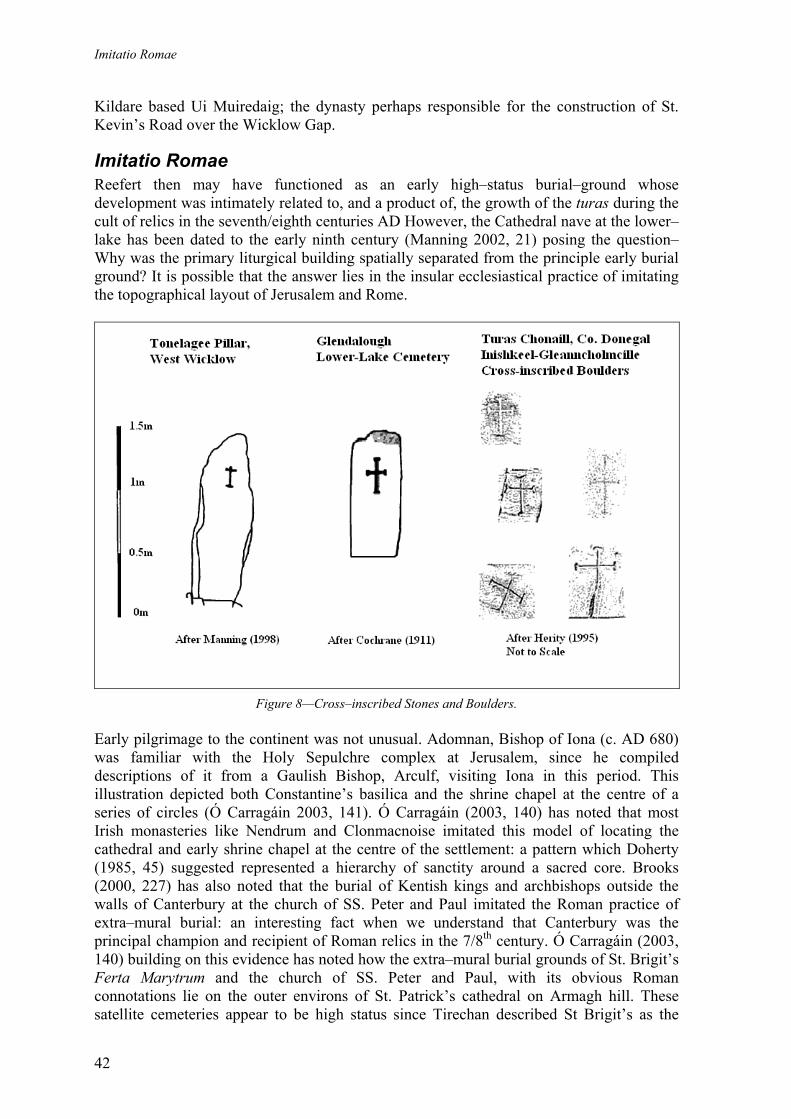
Imitatio Romae
42
Kildare based Ui Muiredaig; the dynasty perhaps responsible for the construction of St. Kevin’s Road over the Wicklow Gap.
Imitatio Romae Reefert then may have functioned as an early high–status burial–ground whose development was intimately related to, and a product of, the growth of the turas during the cult of relics in the seventh/eighth centuries AD However, the Cathedral nave at the lower–lake has been dated to the early ninth century (Manning 2002, 21) posing the question– Why was the primary liturgical building spatially separated from the principle early burial ground? It is possible that the answer lies in the insular ecclesiastical practice of imitating the topographical layout of Jerusalem and Rome.
Figure 8—Cross–inscribed Stones and Boulders.
Early pilgrimage to the continent was not unusual. Adomnan, Bishop of Iona (c. AD 680) was familiar with the Holy Sepulchre complex at Jerusalem, since he compiled descriptions of it from a Gaulish Bishop, Arculf, visiting Iona in this period. This illustration depicted both Constantine’s basilica and the shrine chapel at the centre of a series of circles (Ó Carragáin 2003, 141). Ó Carragáin (2003, 140) has noted that most Irish monasteries like Nendrum and Clonmacnoise imitated this model of locating the cathedral and early shrine chapel at the centre of the settlement: a pattern which Doherty (1985, 45) suggested represented a hierarchy of sanctity around a sacred core. Brooks (2000, 227) has also noted that the burial of Kentish kings and archbishops outside the walls of Canterbury at the church of SS. Peter and Paul imitated the Roman practice of extra–mural burial: an interesting fact when we understand that Canterbury was the principal champion and recipient of Roman relics in the 7/8th century. Ó Carragáin (2003, 140) building on this evidence has noted how the extra–mural burial grounds of St. Brigit’s Ferta Marytrum and the church of SS. Peter and Paul, with its obvious Roman connotations lie on the outer environs of St. Patrick’s cathedral on Armagh hill. These satellite cemeteries appear to be high status since Tirechan described St Brigit’s as the

Lorcan Harney
43
main reliquary and burial ground and excavations at the Ferta Marytrum (burial–ground of Martyrs) revealed evidence for sixth century burial and a possible translation (Ó Carragáin 2003, 171). It is possible that Glendalough also imitated the topography of Rome. O’Brien (1992, 133) has argued that fearta were pagan burial–grounds which were later Christianised. The possible translation of Riogh–Fheart for Reefert suggests that it was an early burial–ground like the Fertae Martyrum at Armagh that developed into a high–status extra–mural cemetery in the 700’s. MacShamhrain (1996) has dated the earliest versions of the Lives of St. Kevin to AD 800, a passage from it refers to the burial–place of the kings of Erin and the relics of bishops which both Price (1940, 266) and Long (1996) have situated at Reefert. Hagiographical references also indicate a connection between Glendalough and Rome which refer to the monastery as a ‘Gracious Rome’ and which associate pilgrimage to Glendalough with that to the Eternal City (Plummer 1922, 139). Another reference from the Lives alludes to Glendalough as one of the ‘four best Romes of burial’ in Ireland (Plummer 1922, 124). Ruama or Romes were importantly early high–status sacred burial–grounds in which the founding Irish saint was said to have sprinkled soil from the tombs of Roman apostles and martyrs around when he returned from his pilgrimage to the eternal city. The term offers supporting evidence that Glendalough was seeking to attract pilgrims as ruama were a form of sacred burial ground intimately associated with the development of the cult of relics in the 7/8th centuries. The original dedication of the cathedral is unclear, but Innocent III’s bull of 1216 describes it as Sanctorum Apostolurum Petri et Pauli de Glindelach (Price 1945, 46–47). While a church with such a dedication should be located in an extra–mural location, it nevertheless attests to contacts with the Eternal City.
Figure 9—Armagh.
The place–name, hagiographical and historical sources support the archaeological evidence that Reefert operated as an early high status burial–ground. The evidence suggests that this relationship between Reefert and the Cathedral was in place sometime during the 7/8th century when the landscape was being formally organised under the influence of the cult of relics and that the 9/10th century archaeological evidence represents a visible demarcation
Imitatio Romae
44
of this arrangement. It appears that the authorities may have deliberately imitated the topography of Rome by retaining Reefert, the ancient burial–ground associated with the Saint, as a high–status cemetery and constructing or transferring the principal liturgical building of the Cathedral to the more spacious lower–lake area at the mouth of the valley during this early period. This unique relationship between the two church–grounds would, however, not last as patronage and high–status burial in the 11/12th century would be focused around the mouth of the valley with Reefert learning to play a different and more subordinate role.
Acknowledgements This paper is based on research undertaken for an MA Dissertation in 2006 at the School of Archaeology, UCD. I would like to express particular thanks to my supervisor Dr. Stephen Harrison and to Dr. Doherty Kelly for great help, advice and comments during and after the MA dissertation. Thanks must also be given to all those other people who have helped me upon the way including Emmett O’Keeffe and Conor Smith for advice about illustrations and the staff at the Visitors Centre in Glendalough for allowing me access to Paddy Healy’s cross–slab survey. A final word of thanks must be given to the editors for organising the conference and bringing the proceedings to publication.
Bibliography Alexander, J. 1978. Insular Manuscripts: Sixth to Ninth Century. London: Harvey Miller. Barrow, L. 1972. Glendalough and St. Kevin. Dundalk: Dundalgan Press. Champneys, A. 1910. Irish ecclesiastical architecture: with some notice of similar or related work
in England, Scotland, and elsewhere. London: George Bell and Sons. Brooks, N. 2000. Canterbury, Rome and the Construction of English Identity. In J. Smith (ed.),
Early Medieval Rome and the Christian West. Boston: Leiden Press, 221–246. Cochrane, R. 1911. Historical and Descriptive Notes with Ground Plans, Elevations, Sections and
Details of the Ecclessiastical Remains at Glendalough, Co. Wicklow. Extract from the Eightieth Annual Report of the Commissioners of Public Works, Dublin.
Colles, A. 1870. Proposal to restore churches at Glendalough. ‘Proceedings’. Journal of the Royal Society of Antiquaries of Ireland 1, 194–201.
Corlett, C. 2003. The Hollywood Slabs– some late medieval grave slabs from West Wicklow and neighbouring counties. Journal of the Royal Society of Antiquaries of Ireland 133, 86–110.
Corlett, C and Medlycott, J. (eds.) 2000. The Ordnance Survey Letters: Wicklow. Dublin: Falcon Print.
Crawford, H. 1907. The descriptive list of the Early Irish crosses. Journal of the Royal Society of Antiquaries of Ireland of Ireland 37, 217–244.
Crawford, H. 1919. Notes on the "doubtful" portrait and the cross–bearing pages in the Book of Kells. Journal of the Royal Society of Antiquaries of Ireland 49, 153–154.
Doherty, C 1984. The use of relics in early Ireland. In P. Ni Cathain and M. Richter (eds.), Ireland and Europe: The Early Church. Stuttgart, 89–101.
Harbison, P. 1991. Pilgrimage in Ireland. The monument and the people. London: Barrie and Jenkins.
Harbison, P. 1994. Early Irish pilgrim archaeology in the Dingle Peninsula. World Archaeology 26, 90–103
Harbison, P. 1999. The Otherness of Irish Art in the Twlefth Century. In C. Hourihane (ed.), From Ireland Coming: Irish Art from the Early Christian to the Late Gothic Periods and its Context within Europe. Princeton: Princeton University Press, 103–120.
Harney, L. 2006 Glendalough: Power, Politics and Religion in an Ecclesiastical Landscape. Unpublished MA Thesis, School of Archaeology, University College Dublin.
Healy, P. 1972. Supplementary Survey of the Ancient Monuments at Glendalough Co. Wicklow. Dublin: OPW.

Lorcan Harney
45
Henry, F. 1937. Early Christian Slabs and Pillar Stones in the West of Ireland. Journal of the Royal Society of Antiquaries of Ireland 67, 265–279.
Herity, M. 1995. Studies in the Layout, Buildings and Art in Stone of Early Irish Monasteries. London: Pindar Press.
Kelly, D. 1988. Cross–carved slabs from Latteragh, County Tipperary. Journal of the Royal Society of Antiquaries of Ireland 118, 92–100.
Kelly, D. 1991. The Heart of the Matter: Models for Irish High Crosses. Journal of the Royal Society of Antiquaries of Ireland 121, 105–45.
Kelly, D. 1993. The relationships of the crosses of Argyll: The Evidence of Form. In R. Spearman, A. Michael and J. Higitt (eds.), The Age of migrating ideas: early medieval art in Northern Britain and Ireland. Edinburgh: Stroud, 219–229.
Leask, H. 1950. Glendalough, official guide to the national monuments. Dublin. Lionard, P. 1961. Early Irish grave slabs. Proceedings of the Royal Irish Academy 61 C, 95–169. Long, H. 1996. Medieval Glendalough: An Inter–Disciplinary Study. Two Volumes. Unpublished
PhD Thesis. Trinity College Dublin. Mac Shamhrain, A. 1993. The UI Muiredaig and the Abbey of Glendalough in the Eleventh to
Thirteenth Centuries. Cambridge Medeival Celtic Studies 25, 55–75. Mac Shamhrain, A. 1996. Church and Polity in Pre–Norman Ireland: the case of Glendalough.
Maynooth: Cardinal Press. Manning, C. 1998. A Cross–inscribed Pillar on Tonelagee Mountain, Co. Wicklow. Wicklow
Archaeology and History 1, 26–28. Manning, C. 2002. A Puzzle in Stone: the Cathedral at Glendalough. Archaeology Ireland 16 (2),
18–21. Macalister, R.A.S. 1916. The History and Antiquities of Inis Cealtra. Proceedings of the Royal
Irish Academy 33C, 93–174. McGuinness, D. 2002. Some antiquities of the Early Christian Period on Three Rock Mountain,
Co. Dublin. Wicklow Archaeology and History 2. 45–60. O’Brien, E, 1992. Pagan and Christian Burial in Ireland during the first Millenium AD: Continuity
and Change. In N. Edwards and A. Lane (eds.), The Early Church in Wales and the West. Oxbow Monograph 16. Oxford: Oxbow, 130–137.
Ó Carragáin, T 2003. The Architectural Setting of the Cult of Relics in Early Medieval Ireland. Journal of the Royal Society of Antiquaries of Ireland 133, 130–176.
Ó Floinn, R. 1998. Clonmacnoise: art and patronage in the early medieval period. In H. King, (ed.), Clonmacnoise Studies: Volume One. Bray: Wordwell, 87–100.
O’Keeffe, T. 1996. Diarmait MacMurchada and Romanesque Leinster: Four Twelfth century churches in context. Journal of the Royal Society of Antiquaries of Ireland 127, 52–79.
O’Keeffe, T. 2003. Romanesque Ireland: Architecture and ideology in the Twelfth Century. Dublin: Four Courts Press.
Plummer, C 1922. Lives of Irish Saints. Oxford. Price. L. 1940. Glendalough: St. Kevin’s Road. In J. Ryan (ed.) Feil–Sgribhinn Eoin Mhic Neill.
Essays and Studies presented to Professor Eoin MacNeill. Faoi Chomhartha na dTri gCoinneal: Ath Cliath, 244–271.
Swift, C. 1995. Dating Irish grave slabs: the evidence of the annals. In C. Bourke (ed.), From the Isles of the North: Early Medieval Art in Ireland and Britain. Belfast, 245–49.
Wilde, W. 1873. Memoir of Gabriel Beranger, and his labours in the cause of Irish art and antiquities; from 1760 to 1780. Journal of the Royal Society of Antiquaries of Ireland 2, 445–485.
Young, S. 1989 The Work of Angels: Masterpieces of Celtic Metalwork: 6th to 9th Centuries. Texas: University of Texas Press.


Maureen Doyle
47
A Tale of Two Saints: Some Perceptions of Identity in Early Medieval Europe Maureen Doyle*
Archaeologies of identity receive increasing attention in the discipline today. One difficulty with applying some of the theoretical approaches to the archaeology of early medieval Europe, however, is the question of whether modern (even post–modern) theories are relevant, and applicable, to people in the past. For a historical period, the written sources can be expected to provide information on how people at the time perceived issues of identity, including such aspects as gender, ethnicity, age, status, etc. However, the pictures of identity which emerge from these sources often seem very strange to modern eyes, suggesting that past people had rather different ideas of what identity meant, and how it was constituted and expressed. We need to take this ‘strangeness’ into account when interpreting the material remains as expressions of past identity. This paper uses case studies of two saints to explore some of the ideas of identity, which circulated in early medieval Europe, and provide possible insights into a more meaningful understanding of past identities.
Introduction Identity has been called “one of the most compelling issues of our day” (Meskell 2001, 204). It includes aspects such as age, ethnicity (or regional, local or tribal affiliation), gender, religion, status and social role. No single one of these aspects alone constitutes identity, which may also change over the course of a person’s life. For this reason, it is increasingly suggested in the literature that identity is less a fixed entity than “a more mutable, fluid set of identifications that are open to re–evaluation and reflexivity” (Meskell and Preucel 2004, 122). In recent years, archaeologists have increasingly addressed issues of identity: what it is, how it is created and perpetuated, how it appears to the individual and the group, and how it is expressed and can be read through material culture (see, for example, Gero and Conkey, 1991; Shennan, 1994; Jones, 1997; Frazer and Tyrrell, 2000; Díaz–Andreu et al., 2005). Archaeology of the body has also been considered, particularly in relation to gendered representations and experiences, and more recently in regard to its own materiality (e.g. Yates, 1993; Rautman 2000; Sofaer 2006). There appears to be a tension between normalised ideas of what the body is and represents, and the possibility of finding individual persons under such universal categories, along with a danger that archaeologists reify the body as an artefact, and in their reconstructions fail to appreciate contemporary perceptions of the body (Gilchrist 1994, 43). Another key theory is that of personhood, defined as “the condition or state of being a person, as it is understood in any specific context …” (Fowler 2004, 7), which archaeologists have debated in a variety of contexts, many of them relating to prehistory. Looking at these approaches to identity across archaeology, anthropology and sociology, however, it quickly becomes clear that much of the theory is very modern, even post–modern, in its underlying principles, in the possible types and facets of identity envisaged, and in interpretations of how people construct and perform their identities. So how relevant are such ideas to people in early medieval Europe? Simply applying modern theories would be anachronistic, particularly when we consider how much of our current understanding of identity derives from very recent times. Both eighteenth–century Enlightenment philosophies and twentieth–century psychoanalytical approaches strongly
* School of Archaeology, University College Dublin

A Tale of Two Saints
48
underpin many modern theories and understandings of identity and how it is constructed, perceived and performed. Such approaches cannot simply be applied retrospectively to the early medieval period, as if people living then were familiar with the works of Descartes and Freud, and their respective followers and critics. We need to set aside our own sense of identity and seek out how people in early medieval Europe would have understood this concept, “thinking [ourselves] into past cultural contexts” (Hodder and Hutson 2003, 237).
Early Medieval Identity Accordingly, we need to look at broad perceptions and understandings of identity in early medieval Europe, bearing in mind the possibility of regional and chronological variations in these ideas. Even a preliminary look at the literature suggests that early medieval perceptions of identity – including issues of gender, ethnicity, age and status – were quite different to our modern understanding. The task is what the Russian historian Aaron Gurevich has called historical anthropology, involving “the reconstruction of the subjective reality which formed the content of the consciousness of people of a given epoch and culture”. In such an endeavour, he argues, the historian – or from my perspective, the archaeologist – must “always be guided by an understanding of the ‘otherness’ of what is being studied” and avoid simply “transferring one’s view of the world to the object of study” (Gurevich 1992, 4, 7). We must observe the strangeness of past peoples’ beliefs without imposing modern ideas and perceptions onto them, avoiding “conflating ancient and modern experience” in considering past identities (Meskell 2001, 204). In this paper, I want to consider how the idea of a ‘person’ was understood in early medieval Europe, and how it was defined – in particular, in terms of the body, and of religious issues. While there is a case to be made for treating the multiple yet interlinked facets of identity in a comprehensive, coherent fashion, the constraints of this paper (and also of the conference presentation on which it is based) dictate against such an inclusive approach. In any event, we must first understand the individual components of identity if we are to integrate them into a whole picture. My starting point is that the modern view of “the indivisible person as a fixed and bounded entity” (Fowler 2004, 16) may not have applied in the early medieval period. Fowler has argued that a change in perception took place between the medieval and Renaissance periods, such that “[a]ttributes of personhood that had been embedded in the world, then, like the self, became increasingly contained within the body” (ibid., 14). In order to explore the boundaries of personhood in early medieval Europe, I propose to take case studies of two saints, spanning both the chronological period and a broad geographical range, to see how they shed some light on how the person, and the body, were viewed in this period, and manifest the strangeness of identity at that time.
Saint Guinefort The story of Guinefort is recorded in the writings of a thirteenth century Dominican friar, Etienne of Bourbon, who tells us that when he was preaching in the Dombes region in the Diocese of Lyons, “numerous women confessed that they had taken their children to Saint Guinefort” to be healed (Schmitt 1983, 4). On making enquiries, Etienne discovered to his consternation that the saint was a greyhound, which had saved the life of the local lord’s child by killing a serpent, which threatened it. However, the dog was mistakenly thought to have killed the child and was itself slain. When the error was discovered, the dog was buried in a well, beneath a pile of stones, and trees were planted beside it. This was not the end of the story, however, for the local peasants, “… hearing of the dog’s conduct and of

Maureen Doyle
49
how it had been killed, although innocent, and for a deed for which it might have expected praise, visited the place, honoured the dog as a martyr, prayed to it when they were sick or in need of something, and many there fell victim to the enticements and illusions of the devil, who in this way used to lead men into error” (ibid., 5). After detailing the demonic rituals involved in the cure, Etienne says that he destroyed the cult by preaching against it, by digging up the dog’s remains and cutting down the “sacred wood” and burning them together, and by passing an edict that anyone frequenting the place would forfeit their possessions (ibid., 6). To our modern eyes, it seems incredible that people could have worshipped a dog as a saint, and we could try to explain the story away scientifically. Thus, the first part of the story contains the international folktale motif of the ‘faithful hound’, catalogued in Aarne–Thompson as B.524, 1.4.1, ‘dog defends master’s child against animal assailant’. This story has been told in many forms, from India in the sixth century BC right up to nineteenth–century Welsh folklore (Schmitt 1983, 39–41, 46). We could also seek out human saints of similar names and attributes, who might have been incorporated into the tale. A prime candidate in this regard is the Irish saint Guinefort, who was martyred in northern Italy in the time of the Roman Emperor Diocletian (late 3rd–early 4th century AD) (ibid., 91). This Guinefort was honoured at Pavia for his healing, especially of children; both his name and association thus resonate with the dog saint of the Dombes. Schmitt has argued that the human saint’s name and cult may well have been brought into southeastern France by the twelfth century, noting links between the cult centre at Pavia and the French Abbey of Cluny and its networks (ibid., 102). He may, therefore, have contributed to the tale recorded by Etienne of Bourbon. But this modern, scientific attitude is not Etienne’s approach. He treats the tale of the dog saint seriously and, while decrying it as an example of superstition, does not take issue with the bodily form of the supposed saint. In a sense, the corporeal appearance of the saint is not Etienne’s priority; his greatest horror is reserved for the superstitious rituals associated with the cult. In this regard, we can note that Etienne is not only a Dominican preacher, but an Inquisitor, one of the first to be appointed after his Order had been given this role by Pope Gregory IX (Schmitt 1983, 11–12). The Inquisition was primarily concerned with ensuring orthodoxy and fighting heresy; Etienne’s denunciation of superstition, which since the time of the Church Fathers had been linked with both heresy and paganism (ibid., 14), was fully in accord with this. His vocabulary in presenting the tale clearly illustrates this focus, from the introduction when he says that “[o]ffensive to God are those [superstitions] which honour demons or other creatures as if they were divine …” to his references to “enticements and illusions of the devil” and “the rituals they should enact in order to make offerings to demons, and in order to invoke them…” (ibid., 4–5). There are also parallels between Etienne’s account of his destruction of the trees growing around the dog’s grave, and accounts of various saints, including Martin of Tours, Boniface and Amator, who cut down pagan sacred trees or woods as part of the conversion process (ibid., 17–18, 122). I would suggest that, to Etienne, the non–human form of the saint’s body was just one more element of superstition, and that he was more concerned about the pagan ramifications of the cult. Indeed, as Schmitt points out, to orthodox eyes, “any attempt by peasants to define the criteria of sanctity (even had the saint been a man) would have appeared subversive …” (ibid., 19). For the Dominican Etienne, therefore, the fact that the saint was a dog was perhaps just another indication of the superstitious errors and heresies of the peasants of the Dombes, which had to be stamped out.

A Tale of Two Saints
50
But again, this is the outsider’s view, which we might dismiss as Inquisitorial propaganda. Can it really be possible that some people in the thirteenth century in a part of eastern France actually viewed a dog as a saint? To understand this, we need to consider some of the beliefs around identity, which held sway in early medieval Europe, particularly those concerning monsters. People believed that the corporeal boundaries between humans and animals could become blurred, to the extent that personhood crossed the threshold from the strictly human to the ambiguous – and perhaps even to the wholly bestial. In this regard, we might recall a modern definition of personhood as being “… attained and maintained through relationships not only with other human beings but with things, places, animals and the spiritual features of the cosmos. Some of these may also emerge as persons through this engagement” (Fowler 2004, 7: emphasis mine). While this jars with the modern, western understanding of personhood as being highly individualized, with people’s bodies seen almost as private property, other modern societies have different interpretations of personhood; these include the idea of “dividuals”, where different aspects of the person such as body, mind and soul “may not be fixed in the matter of the body, but either enter into or emerge from the person during certain occasions” (ibid., 3, 8). Perhaps we should also consider the possibility that some aspects of early medieval identity could be located in non–human bodies.
Figure 1—B lemmyae from Wonders of the East (11th century) (Friedman 1981, 153).
The ‘Monstrous Races’ Ideas of monstrous peoples, half–human races, dwelling beyond the borders of the familiar realms, are first found in the fifth century BC in the writings of Ctesias the Greek, whose Wonders of India, with its stories of the diverse and strange inhabitants of that distant place, was subsequently transmitted to the Latin–speaking world in Pliny’s Natural History (Friedman 1981, 7). These ideas continued to be perpetuated and propagated in early medieval Europe by Christian writers. In the fifth century AD, St. Augustine of Hippo, in The City of God, discussed in theological terms whether the monstrous races were descended from Adam, and thus part of God’s plan for the salvation of humanity (Austin 2002, 47). While not firmly committing himself to believing that the monstrous races had souls, Augustine did assert that a “… rational mortal creature, however strange he may appear to our senses in bodily form or colour or motion or utterance, or in any faculty, part or quality of his nature whatsoever … is descended from the one man who was first created” (City of God 16.8, quoted in Friedman 1981, 91: emphasis mine). In the seventh century AD, Isidore of Seville also included these races in his Etymologies, and discussed inter alia the possibility that men could be physically changed into animals (Austin 2002,

Maureen Doyle
51
42). The fact that such scholars treated these tales seriously, and saw them as having a part to play in the cosmos and society, argues for their strong place in the early medieval mentality. Over the centuries, these stories passed from learned literature into folklore, art, religion, and the general psyche. Sources such as the eleventh–century Anglo–Saxon manuscript Wonders of the East (British Library MS Cotton Tiberius B.v.) present us with such strange hybrids as the cynocephali (dog–headed men), homodubii (men above the waist, but asses below), the panotii (big–eared people) and blemmyae (headless men with faces in their torsos) (Figure 1) (Austin 2002, 31–41; Friedman 1981, 19, 153). Some of these monsters could speak intelligibly, while others were restricted to producing animal sounds. Some even lived in societies resembling those of humans. In the early ninth century, the missionary St. Rimbert was reassured by the monk Ratramnus of Corbie that the half–human, half–animal creatures he might expect to meet in Scandinavia could be regarded as rational creatures, as the cynocephali, for example, herded flocks and wove clothes (Mâle 1978, 330). The issue of dress was frequently commented on; according to Ctesias, the cynocephali dressed in animal skins and were hunters. The pygmies, on the other hand, were sometimes said to wear clothes woven from their own hair (Friedman 1981, 31). While the use of skin or hair clothes suggested their wearers were located somewhere between human and animal, Ratramnus’s cynocephali who wove clothes from the wool of their flocks perhaps lay closer to the human end of the spectrum.
Figure 2—Tympanum at Ste.–Marie–Madeleine, Vézelay (Yonne) (Mâle 1978, 327).
My point in stressing the monstrous races is that they show that modern understandings of bodily identity and corporeal boundaries, in particular those between humans and animals, were not shared by people in early medieval Europe. Greta Austin put it succinctly: “The line between human and animal in the early Middle Ages could be blurry: no category or taxonomy existed which might drive a firm, comforting wedge between human being and animal” (Austin 2002, 42). A further discomforting idea arising from these blurred boundaries was that a person might become an animal, or part animal – as already mentioned, this possibility was discussed by Isidore of Seville. This may go some way to explaining not only tales of werewolves and other such bodily transformations, but also the legend that Englishmen grew dog–like tails when cursed by St. Augustine of Canterbury for insulting his mission to convert the Anglo–Saxons (Cohen 1999, 140–1).

A Tale of Two Saints
52
But how widespread were these views? While written texts might seem to relate only to the scholarly and literate elite, many genres were intended to be read or preached to those who could not read (Gurevich 1988, 3–4). Oral transmission was still a key means of spreading, and perpetuating, information and beliefs. Monsters and other strange beings were also made visible to large numbers of people through sculpture, especially church sculpture. Emile Mâle has pointed out a number of twelfth–century French representations of the monstrous races, for example on a pillar from the abbey church of St.–Pierre, Souvigny (Allier) (Mâle 1978, 324). Another prime example is to be seen on the tympanum of the great portal of the Abbey Church of Ste.–Marie–Madeleine at Vézelay (Yonne). (Figure 2) This scene represents either the moment of Pentecost (ibid., 329) or the subsequent Mission of the Apostles (Cohen 1999, 132); in either case, the key point is to preach the Gospel to all the peoples of the world – or, in some translations of the Bible, ‘all the creatures of the world’ (emphasis mine). The Vézelay tympanum differentiates these peoples through both costumes and appearances, and it includes several of the monstrous races (Mâle 1978, 328–331). The panotii and pygmies are depicted on the lintel at the base of the tympanum; higher up are the cynocephali, who stand awaiting, as Cohen puts it, “the arrival of the apostolic Word that will render them more human” (Cohen 1999, 132) (Figure 3). Such scenes would have been more widely accessible than written manuscripts, and their location on the exterior of church buildings would have contributed to the dissemination of ideas of blurred bodily identities.
Figure 3—Detail of cynocephali on Vézelay tympanum (Friedman 1981, 81).
Saint Christopher This blurring of boundaries between human, animal and monster can also be seen in the case of St. Christopher. Here we must begin by setting aside the modern image in favour of the saint’s original form, as it was known in early medieval Europe. While the late medieval and modern representation of the saint is as a large man who carries the Christ Child on his shoulders, this image only dates back to the so–called ‘Golden Legend’ of the thirteenth century. The original Christopher was rather different. (Figure 4) The earliest Greek Lives say that he was a cynocephalus, a dog–headed monster, who by the grace of God was converted and given the gift of speech, only to be martyred for his faith. These Lives were widely known throughout Europe, being translated not only into Latin, but into

Maureen Doyle
53
many vernaculars including Old English and Middle Irish (Lionarons 2002, 167). The Irish Passion of St. Christopher, although preserved in the fifteenth–century Leabhar Breac, is written in Middle Irish dating to the period from 900 to 1200 AD. It describes the saint as “… a man with a dog’s head on him, and long hair, and eyes glittering like the morning star in his head, and his teeth were like the tusks of a wild boar” (Fraser 1913, 309). The description in the Old English Martyrology is similar (Friedman 1981, 73), demonstrating the common roots of both vernacular Lives. Clearly, this image of the dog–headed saint circulated widely across both time and space in early medieval Europe. Nor was it confined to the written word. As well as appearing in icons and sculptures, Christopher’s image was painted on the walls of medieval towns, as a protection for travellers (Cohen 1999, 120), again providing an accessible visual means for the transmission of ideas.
Figure 4—St. Christopher from a 12th century Martyrology (Stuttgart Landesbibliothek).
So if a dog–headed monster could be regarded as a saint throughout the early medieval period, perhaps it is not surprising that people in the Dombes prayed to a dog in the thirteenth century, even if that tale probably conflates the folktale motif and the healing powers of the human Guinefort of Pavia. This is not to suggest that the dog saint Guinefort was directly inspired by the dog–headed Christopher. But the ideas and images which permeated early medieval Europe could have played a part in the ready acceptance of a dog saint, making it less strange than we might nowadays think. The issue of metaphor is relevant here. Those who created and wrote about these images were learned, literate people, who may have used the metaphor of a dog–headed saint to highlight the power of Christianity, which could convert even monsters. As John Block Friedman has pointed out, “the Cynocephali were attractive to the missionary spirit because of their established reputation. The early Greek travelers had described their appearance and customs at considerable length, stressing that they combined the natures of

A Tale of Two Saints
54
man and beast and, in some accounts, were cannibals. Their conversion would be a special and dramatic triumph for Christian propagandists” (Friedman 1981, 61). It is not surprising, therefore, that some of the early apocryphal Acts of the Apostles describe the conversion of these monsters. The Ethiopic text, Contendings of the Apostles, describes one such cynocephalus in terms very similar to those used in the later Irish Passion of St. Christopher:
“…his face was like unto the face of a great dog, and his eyes were like unto lamps of fire which burnt brightly, and his teeth were like unto the tusks of a wild boar, or the teeth of a lion, and the nails of his hands were like unto curved reaping hooks, and the nails of his toes were like unto the claws of a lion, and the hair of his head came down over his arms like unto the mane of a lion, and his whole appearance was awful and terrifying” (Friedman 1981, 70–71, quoting from Budge 1935, 173–74).
That even such creatures could become Christians, and assistants to the apostles in their mission, shows that “[c]onversion … not only bestows grace and salvation … but to some degree it removes monstrosity as well” (Friedman 1981, 71). As already noted, the widely–disseminated writings of Christian scholars such as Augustine and Isidore, show that people saw nothing strange in the idea that such monsters existed as part of God’s creation, nor that they could achieve sanctity and religious identity on a par with humans. The dog–headed St. Christopher, like the cynocephali converted by the apostles, may have begun as a metaphor for the power of God. However, while metaphors are understood as such by the literate scholars who first use them, others may interpret them quite differently (Gurevich 1988, 11). Thus the dog–headed monster, when converted, is given the name Christopher, from the Greek for ‘Christ–bearer’. This naming itself was a metaphor for the conversion process; a Christ–bearer was one who had taken up Christ and carried him in his or her heart. But if the metaphor is taken literally, it may prompt the modern image of a giant physically carrying the Christ Child on his shoulders.
Implications But the question still remains: if a dog and a dog–headed monster could be regarded as saints, what does this say about early medieval ideas of personhood? Religious identity may be the key to both of these case studies: if the important thing was the power of God displayed in converting a monster to a Christian martyr, or in providing healing through a dog, then maybe the saint’s bodily form was less relevant. Perhaps in these cases it was religious identity, which conveyed personhood. In the case of Christopher, it was the gift of human speech, which allowed him to praise God, and humanised him, although his appearance remained unchanged (Lionarons 2002, 178). In the circumstances, his monstrous body was a secondary consideration, and this may also have been the case with Guinefort. Early medieval people may not have cared whether their saints took human, monster or animal form: what mattered was that they provided a religious service – healing, protection, and intercession – to those who prayed to them. While Insoll has argued that underlying biology proves that “bodies are not purely socially constructed” (Insoll 2007, 4), there is a sense in these cases that social perceptions or imputations of value or role to a particular body may allow its physical form and genetic construction to be transcended. Thus, a biological dog may be placed on a par with a human saint, and a monster may become Christian and ‘human’ without changing his physical form. The stories of these two saints have some important implications for the general interpretation of identity in early medieval Europe. Firstly, they confirm Gurevich’s idea of
Maureen Doyle
55
the ‘otherness’ of the past, and the need to set aside one’s own views and beliefs in order to access and understand past senses of identity. Bodily identity and personhood in early medieval Europe were certainly sometimes viewed, and experienced, in quite different terms than those available to modern scholars. Secondly, they suggest that if religious identity was the key to these cases, it might also be predominant in other, less extreme, circumstances. Alternatively, other facets of identity might play a determining role in particular situations. The interplay of such aspects may further complicate how archaeologists read past identity from material remains. Finally, we can see the extent to which identity is also determined and perceived in accordance with a person’s social role, as in the key religious role or function of the two saints discussed in this paper. As Chris Fowler puts it,
“… it does not matter whether past things were definitively people or not: what matters is the effect that they have on social relations.” (Fowler 2004, 160)
Acknowledgements Thanks to my supervisor, Dr. Aidan O’Sullivan; to the UCD Ad Astra Research Scholarship for funding my research; to the Humanities Institute of Ireland, UCD; to my colleagues in the early medieval research cluster in UCD; and last but not least, to the AYIA organising committee 2007.
Bibliography Austin, G. 2002. Marvelous Peoples or Marvelous Races? Race and the Anglo–Saxon Wonders of
the East. In T.S. Jones and D.A. Sprunger (eds.) Marvels, Monsters and Miracles. Studies in the Medieval and Early Modern Imaginations. Studies in Medieval Culture XLII. Medieval Institute Publications: Kalamazoo MI, 25–51.
Budge, E.A.W. (trans.). 1935. The Contendings of the Apostles. London: Oxford University Press. Cohen, J.J. 1999. Of Giants. Sex, Monsters and the Middle Ages. Medieval Cultures, Vol. 17.
Minneapolis and London: University of Minnesota Press. Díaz–Andreu, M., Lucy, S., Babić, S., and Edwards, D.N. 2005. The Archaeology of Identity.
Approaches to gender, age, status, ethnicity and religion. London and New York: Routledge. Fowler, C. 2004. The Archaeology of Personhood. An anthropological approach. London:
Routledge. Fraser, J. 1913. The Passion of St. Christopher. Review Celtique 34, 307–25. Frazer, W.O. and Tyrrell, A. (eds.) 2000. Social Identity in Early Medieval Britain. London and
New York: Leicester University Press. Friedman, J.B. 1981. The Monstrous Races in Medieval Art and Thought. Cambridge MA and
London: Harvard University Press. Gero, J. and Conkey, M.W. (eds.) 1991. Engendering Archaeology. Oxford: Blackwell. Gilchrist, R. 1994. Medieval bodies in the material world: gender, stigma and the body. In S. Kay
and M. Rubin (eds.) Framing medieval bodies. Manchester and New York: Manchester University Press, 43–61.
Gurevich, A. 1988. Medieval popular culture: problems of belief and perception. Trans. János M. Bak and Paul A. Hollingsworth. Cambridge: Cambridge University Press.
Gurevich, A. 1992. Historical Anthropology of the Middle Ages. ed. J. Howlett. Cambridge: Polity Press.
Hodder, I. and Hutson, S. 2003 (3rd edn.). Reading the Past. Current Approaches to Interpretation in Archaeology. Cambridge: Cambridge University Press.
Insoll, T. 2007. Introduction. Configuring identities in archaeology. In T. Insoll (ed.) The Archaeology of Identities. A reader. London: Routledge, 1–18.
Jones, S. 1997. The Archaeology of Ethnicity. London: Routledge.

A Tale of Two Saints
56
Lionarons, J.T. 2002. From Monster to Martyr: The Old English Legend of St. Christopher. In T.S. Jones and D.A. Sprunger (eds) Marvels, Monsters and Miracles. Studies in the Medieval and Early Modern Imaginations. Studies in Medieval Culture XLII. Medieval Institute Publications: Kalamazoo MI, 167–82.
Mâle, E. 1978. Religious Art in France. The Twelfth Century. A Study of the Origins of Medieval Iconography. ed. H. Bober, trans. M. Mathews. Princeton, NJ: Princeton University Press.
Meskell, L. 2001. Archaeologies of Identity. In I. Hodder (ed.) Archaeological Theory Today. Cambridge: Polity Press, 187–213.
Meskell, L. and Preucel, R.W. 2004. Identities. In L. Meskell and R.W. Preucel (eds.) A Companion to Social Archaeology. Oxford: Blackwell, 121–141.
Rautman, A.E. 2000. Reading the Body. Representations and Remains in the Archaeological Record. Philadelphia: University of Pennsylvania Press.
Schmitt, J–C. 1983. The holy greyhound: Guinefort, healer of children since the thirteenth century. Trans. M. Thom. Cambridge: Cambridge University Press.
Shennan, S. 1994. Introduction: archaeological approaches to cultural identity. In S. Shennan (ed.) Archaeological approaches to cultural identity. London: Routledge, 1–32.
Sofaer, J.R. 2006. The Body as Material Culture. A Theoretical Osteoarchaeology. Cambridge: Cambridge University Press.
Yates, T. 1993. Frameworks for an Archaeology of the Body. In C. Tilley (ed.) Interpretative Archaeology. Oxford and Providence RI: Berg, 31–72.

Rebecca Boyd
57
Norse Houses in Ireland and Western Britain AD 800 – 1100: A Social Archaeology of Dwellings, Ethnicity and Culture Rebecca Boyd*
It is widely recognised that houses are not merely physical objects; they are social and symbolic spaces that enable and structure culturally accepted protocols and practices through their layout for the benefit of both occupants and visitors. Exploring the uses of space within and around buildings provides unique insights into the societies that used them. The Norse houses of Ireland and western and northern Britain offer an exceptional opportunity to explore the role, which these houses played in expressing the distinct cultural, social and ethnic identities of their inhabitants. These structures display common, distinctive physical characteristics that suggest a dominant regional Norse culture, where architectural traditions were maintained to actively preserve or even create a “Viking” culture. New Ph.D. research in UCD is exploring how these houses can be investigated using spatial analysis techniques to illuminate the cultural and social agendas of their occupants, neighbours and visitors. The project will consider how these houses (as cultural artefacts) embodied, maintained and gradually transformed the social identities of immigrant Norse settlers in newly settled lands.
Introduction Over the past thirty years, the Norse houses of Ireland and Britain have emerged as one of the most potent symbols of our Viking past. The post and wattle houses of Dublin and York jostle with the stone built longhouses of the Northern and Western Isles in our minds. They evoke images of peaceful, settled Norse families who engaged in farming, craftwork and trading, as well as indulging in the age–old traditions of raiding and piracy. From the outside, these houses appear to have little in common – the cramped urban conditions look far different from the imposing stone and turf constructions of rural sites – but upon entering these houses, internal similarities become clear. Three aisled divisions, central hearths, similar objects scattered around the different parts of the living areas: these similarities have been used to suggest the existence of a dominant regional Norse culture which was expressed via shared languages, artefact assemblages, cultural practices and, of course, these architectural similarities. On this basis, some may consider these houses to have expressed themselves: they are obvious indicators of cultural identities and affinities. This is too simplistic an interpretation, which does not take into account more recent advances in the interpretation of houses and space as cultural entities or in the understanding of more flexible identities. It also ignores the growing awareness of a much greater degree of native and Viking integration in these lands (as evidenced by the papers presented at the Viking Identities Network Seminar Series, Lee and Jesch 2007).
The Houses The project’s study area consists of Ireland, Scotland, Wales, northwest England, and the Isle of Man. The close connections between these areas are rarely explicitly mentioned, however, these areas were closely linked via the main sailing route from Norway to the Irish Sea. This route ran from Norway to the Faeroes, then south to the Orkney and Shetland Islands, around the north and west coasts of Scotland, and into the Irish Sea basin (Christensen 2000, 95–97). It would have had huge significance for the lives of those who * School of Archaeology, University College Dublin

Norse Houses in Ireland and Western Britain
58
lived along it, whether they were natives experiencing the arrival of the Viking settlers, or settlers participating in a vibrant maritime communications network. As a route, it not only brought in new influences from Scandinavia, but also exported local influences outwards back towards Scandinavia. This must have resulted in a mingling of cultures and identities, which should be observable in much of the archaeological remains. This research is concerned with the structural remains of the Viking Age, primarily the houses which can be neatly split into two categories: urban and rural. The urban houses are the Irish material (Dublin, Waterford, Wexford and Cork) while the rural houses are found predominantly in Scotland and the Isle of Man, but there are also some possible sites from Ireland, northwest England, and Wales. The first Irish Viking houses were excavated in the 1960’s as part of pre–development works around Dublin Castle. Since then, more than three hundred and fifty structures have been excavated in Dublin alone. P.F. Wallace has identified seven building types in the corpus of houses from Dublin, Waterford and Wexford, which he has arranged in a Hiberno–Norse Building Typology (Wallace 1992a, 53–62, 2005, 828–831). In the past five years, at least ten houses have been excavated in Cork, and preliminary reports suggest that they conform to Wallace’s typology (Ní Loingsigh 2003). The Type 1 house is the main building, found in the four main Viking towns. It is a rectilinear house of post and wattle construction, with a three aisled division and rounded corners. It has a central hearth, areas of stone or timber paving (usually in corners or doorways), and opposing doors in the short walls. Lines of post and wattle usually delimit side aisles: these are normally presumed to have acted as raised benches for sitting or sleeping rather than as fully separate rooms (see Figure 2 for a plan of a typical Type 1 building).
Table 1—Details of Hiberno–Norse Building Typology and distribution of each building type (Ní Loingsigh 2003; Wallace 1992a, 53–62; 2001, 44–49; 2005, 828–831).
The next most widespread building type is the sunken–floored structure – Type 4 – which has been found in three towns. The Waterford buildings are structurally more complex than the Dublin or Limerick ones, and may, in the future, require a reclassification in the Typology. The Type 2 building is found in association with the Type 1 building, and appears to have been for human use as it is roofed and supplied with wattle matting. It is found in both Dublin and Waterford, with the main difference between the two towns being the more frequent occurrence of hearths in Waterford. The Type 5 structures are a set of very simple structures found only in Wood Quay, which include lean–tos, huts and pens that acted as pigsties, and tool sheds. The Type 3 buildings are also only found at Wood Quay, and are a slimmed down version of the Type 1 house, which probably evolved to fit the size constraints of plots 5 and 6. Building Types 6 and 7 date to the twelfth and thirteenth centuries and display advanced construction methods (sill beam construction and stone footings), but are not yet found outside Waterford.
Type Description Dublin Waterford Wexford Cork Limerick 1 Main dwelling house 2 Small occupation house 3 Mini type 1 house 4 Sunken floored structure
5 Non habitational structures 6 Sill beam construction 7 Stone footed construction

Rebecca Boyd
59
In comparison to these various urban building types, the rural structures almost all conform to the more traditional North European longhouse architecture. There are three possible Viking period farmsteads in northwest England (Coggins et al. 1983, Edwards 1998, King 1978), and five definite sites on the Isle of Man (Cubbon 1983, 13–26). In north Wales, one possible Viking period manufacturing/trade site has been identified (Redknapp 2004, 139–175), whilst in Ireland, there are two rural sites, which are accepted as potentially Viking sites (Ó Néill 1999, 2006, Sheehan et al. 2001). The majority of the rural material is from Scotland, where approximately one hundred structures have been dated to the Viking and Late Norse period (Graham–Campbell and Batey 1998, 155–205). The structural tradition of the Norse farmstead in Scotland is a rectangular building with a double stonewall construction, again with bowed walls and a three aisled division. The central hearth is present as are typical longhouse divisions of space into human habitation areas and animal byres. Several sites were occupied before the arrival of the Vikings and show significant changes in occupation patterns around this period. The most emphatic of these are where the native cellular buildings were demolished and built over, as at Buckquoy and Saevar Howe, both on Orkney, (Hedges 1983, Ritchie 1976–77) and the Udal, on North Uist (Crawford 1986). This has led to theories of forcible takeover of the Scottish islands, but it must be pointed out that there are other sites, which do not display this abrupt break in tradition. One such site is Pool on Sanday, where the ninth century settlement displayed a very mixed character, implying that assimilation of Norse and Pictish cultures occurred at this settlement (Hunter 1990, 190–193).
Spatial Archaeology Houses have always been seen as being of crucial archaeological, anthropological and historical importance in the reconstruction of past societies. They are social and symbolic spaces that enable and structure culturally accepted protocols and practices for the benefit of both occupants and visitors (Carsten and Hugh–Jones 1995, 1). Exploring the architecture and spaces within and around buildings provides us with unique insights into the culture and societies that used them (Brück 1999, 145, Hillier and Hanson 1984, 1–25) Archaeological approaches to household architecture and domestic space vary from the functional to the post–processual, but can generally be divided into two categories. The first category is heavily influenced by sociological and anthropological theories such as Bourdieu’s habitus or variations on Anthony Giddens structuration theories (O'Sullivan forthcoming). They rely on the idea that repetitions of social or cultural activities structure space, and that the people who utilise the space are culturally instructed by the structure of that space. The second category concerns more quantitative or scientific analyses of space, for example, access analysis (Cutting 2003, 2006), statistical analyses of artefact or feature distributions (Kooyman 2006), or scientific investigations of space, for instance archaeo–environmental studies of floor compositions to identify different activities (Reilly 2003). Previous investigations of space in Norse houses include geoarchaeological and access analyses of the Iceland houses (Milek 2006), the S.E.A.R.C.H. (Sheffield Environmental and Archaeological Research Campaign in the Hebrides) project’s work at Bornish and Kilpheder in the Western Isles (Parker–Pearson et al. 2004) and the seminal work at the chieftain’s farm at Borg in Lofoten from the 1980’s (Munch et al. 2003). Access analysis is a method of spatial analysis, which examines the relationships between distinct spatial units as they are expressed in terms of boundaries, access ways and permeability, usually from the view of an outsider (Foster 1989b, 42–44). It is usually more commonly found in studies of complex architectural structures such as castles

Norse Houses in Ireland and Western Britain
60
(Fairclough 1992), villas (Scott 1990) and even Iron Age wheelhouse brochs (Foster 1989a, b). Access analysis is based upon quantitative space syntax, and has been criticised as being reductivist and outdated (Karen Milek, pers. comm.). Many of the archaeological applications of access analysis date from the 1990’s, but several scholars have recently been re–examining the usefulness of the technique. In a recent paper examining prehistoric Anatolian settlements, Marion Cutting demonstrated that applications of access analysis to archaeological data have faced considerable difficulty because of poor preservation of architectural details or ambiguous evidence for access. However, she concluded that as a qualitative “‘tool to think with’”, access analysis can be of great benefit in visually comparing spatial units (Cutting 2003, 1). It can highlight repeated patterns of association between different types of spatial unit and the activities, which occur in them. Provided there is enough clear archaeological evidence, access analysis can allow us to explore issues of private versus public space. Karen Milek has also used access analysis in what is perhaps a more relevant context: the examination of houses and house layouts in early (9th and 10th century) Icelandic society. Following detailed studies of approximately ninety Icelandic structures, she concluded that the public spaces of the houses – the central living room – conformed to cultural norms, while gable rooms and annexes were private spaces, which varied in their arrangement and use (Milek 2006, 146). At first glance, the houses from the Irish Sea region may not appear to be ideal candidates for access analysis: they do not have obvious internal boundaries and rarely contain more than two doorways. However, their very simplicity may actually be of benefit, as often the intricate graphs that result from access analyses of complicated structures confuse the reader and add little to the interpretive process. As Milek showed, the access analysis of apparently simple longhouses can be a very fruitful method of investigation. With all this in mind, it was decided to apply access analysis to one entire building level at Wood Quay in Dublin to explore the potential of these structures.
Figure 1—Plot layout of Building level 8, Wood Quay (from Wallace 1992b, Figure 10).
Access Analysis at Wood Quay Wood Quay is the premier Viking Age site of Dublin, which was excavated under controversial circumstances in the 1970’s and early 1980’s. The site contained fourteen building levels dating from after the re–foundation of Dublin in 917AD up to the twelfth century. These levels showed continuity of plot boundaries throughout this period and revealed more than one hundred separate structures. From this sequence, Building Level 8 was chosen for the pilot access analysis study. This level dates to the eleventh century and contains seventeen structures (see Table 2 for details of each structure).

Rebecca Boyd
61
Building Building Type
% of Floor Area Excavated
Function
FS48 1? Unknowable Possible dwelling? FS49 1 97.50% Main dwelling house FS50 1 100% Main dwelling house FS51 1 100% Main dwelling house FS52 Uncertain 100% Animal enclosure? FS53 Uncertain 100% Animal enclosure? FS54 1? Unknowable Possible dwelling? FS55 3 100% Main dwelling house FS56 1 Unknowable Main dwelling house? FS57 Unknown Unknowable Unknown FS58 3 100% Dwelling house FS59 1 34% (est.) Main dwelling house FS60 1 100% Main dwelling house FS61 1 83% (est.) Main dwelling house FS62 1 78% Main dwelling house FS63 1 89% Main dwelling house FS64 5 100% Hut
Table 2—Details of buildings on Level 8 (Wallace 1992c, 151–161). Three separate spatial units were recognised for this study: undifferentiated spaces (e.g. corners, porches, and benches), hearth spaces (generally the centre of the central aisle) and yard spaces. The occurrences of each of these units were mapped in each plot using information from the buildings catalogue, and then linked using access routes (see example of Building FS60, Figure 2 below). For the purposes of this study, three assumptions were made. Firstly, the analysis was carried out from the point of view of a person standing in front of the houses on the presumed road. Secondly, each house would have had a yard space in front of the house, through which anyone entering the house would have had to pass. Finally, access to the side aisles was via the middle of the central aisle. This simple access analysis was then justified, relating depth and ease of access from one spatial unit to the next in a gamma analysis. This process was carried out for each building and plot in Level 8, and the resultant gamma analyses are presented below Figure 3. Several relationships emerged from this analysis, some of which were expected, but others were not. The first relationship deals with the internal layouts of the buildings and the means of access to different spatial units. The overall pattern is one of non–distributedness, i.e. where access from one spatial unit to another is not direct and a third point is involved in travelling between the two units. An illustration of this non–distributedness is access from the corners of the buildings into the side aisles, where, in order to access the side aisles from the corners, the person must re–enter the centre of the house. This shows household control over space and displays the existence of controlled patterns of movement through the building, despite the lack of obvious routeways. However, there is insufficient evidence available to verify all the means of access to the side aisles and it is

Norse Houses in Ireland and Western Britain
62
Figure 2—A: Building FS60, Plot 9, Building Level 8, Wood Quay, mapping of spatial units in a typical Type 1 building (from Wallace 1992b, Figure 111 with additions). B: Gamma analysis of Building FS60 with key.
Figure 3—Gamma analysis of occupied plots at Building Level 8, Wood Quay (key in Figure 2).

Rebecca Boyd
63
possible that there may have been direct access from the corners to the side aisles, particularly if the aisles functioned as raised benches rather than separate rooms. In this case, the non–distributedness seen here would change dramatically to a much more distributed and even plan, yet it would still display patterns of controlled movement. There is also variation in the presence and absence of hearth units: five of the plots did not have any building, which contained a hearth. This may be due to the limits of excavation for some plots, where full house plans were not retrieved. However in others, it does raise questions about why some of these supposedly habitational buildings were not provided with hearths. What activities were occurring inside them that it was not thought necessary to provide a hearth? When analysing the access to the yard areas behind the houses, there is evidence for varied means of access. In most plots (1, 3, 6, 7, 9, 10 and 11) the only access to the rear is via the main house, this is a controlled, non–distributed access, consistent with traditional interpretations of the main house on the plot as public space, and the rear of the plot as private space. In plots 2, 4, 5 and 12, there is a completely different use of space. In these plots, access to the private rear yards is possible via the main house, but can also be gained by circumnavigating the house. The main house is set away from the boundary fence (in plot 4, the gap measures up to two metres), leaving enough space to allow free passage through into the rear yard. There are several possible practical explanations for this, for example, plot 4 contains 2 possible animal pens. The 2m wide side passage here may have been to allow easy movement of the animals without bringing them through the main dwelling house where they may cause damage either to the building contents or to themselves. This does not explain the situation in plot 5 though, where the ancillary building is a Type 3 building for human habitation. Perhaps this was a Viking Age granny flat, and it was provided with direct access for the convenience of its occupant! At plot 12, the side passage leads directly to a large pit at the rear of the main house. The pit may have acted as a communal refuse pit, and the passage may have been created to allow occupants of other plots bring their waste directly to the pit without tramping dirt and grime through the main house. The patterns evident in these plots contrast with the more conventional arrangements in the other plots, and raise questions of control and organisation at both household and community level. It also raises the question of whether or not the rear yard does actually act as private space if it can be accessed so easily. Despite initial scepticism about the applicability of access analysis to Norse houses (because of the simplicity of these structures and their lack of obvious internal access routes), this pilot study supports Cutting’s endorsement of access analysis as a useful ‘tool to think with’. This analysis of just one building level at Wood Quay has shown that the physical patterns visible in the access analysis highlight underlying issues relating to distribution, use and control of space. Further work is necessary to explore whether these patterns are anomalies in this building level, or if they exist elsewhere in the stratigraphic sequence. This will be undertaken by expanding the analysis to other building levels above and below Level 8. The results of this expansion may point to wider cultural factors at play in the distribution and control of space. Following on from this, other methods of spatial analysis (such as functional zone analysis, activity area identification and boundary theory and network analysis) will be applied to the houses in order to derive as much information as possible from the remains. In order to do this successfully, more data will be needed to definitively identify different types of spatial unit, for example, thresholds, true corner units, paved areas, storage areas, craft/workshop areas, animal areas. Levels of preservation and archaeological recording vary significantly from site to site, and so there

Norse Houses in Ireland and Western Britain
64
will need to be a degree of flexibility built into the final methodology. However, once patterns in the use of space have been identified, work will begin on unravelling their social and cultural meanings. It is at this level of enquiry that themes such as household relationships, family, community, gender, trade and communications will first emerge.
Interpreting Space Socially? When initial analyses of the space are completed, the project will move forward into the next phase of study where the spatial patterns will be interrogated in terms of their potential social and cultural meanings. Issues such as personal relations, communications, social boundaries, family relations, gender, status and so on will be examined and elevated to a higher level of interpretation as components of the social and cultural identities of the inhabitants. As only preliminary investigations into the houses have been carried out to date, the concepts presented here are tentative explorations of themes for further investigation once more sophisticated spatial analyses are underway. The first theme relates to native and Norse interactions in the colonies, and how these interactions may be visible in the houses. Linked to this then, is a consideration of the proposal for the existence of a dominant regional Norse culture in the Norse colonies. In terms of native and Norse interactions in Ireland, the historical records show that alliances between Irish tribes and Viking raiding parties were common from the mid ninth century onwards. These alliances may have been temporary, perhaps joining forces to carry out large scale slave raids, or they may have been longer lasting political alliances. One way of consolidating political alliances is marriage between the two sides, and this is attested to in both the historical and literary sources, which often refer to such marriages. The written sources also show intermixing of Norse and Gaelic personal names from the ninth century onwards (Fellows–Jensen 2001, 111, Ó Cuív 1988–88), implying that marriages between the two sides were common. In Norse culture, women wielded considerable power over domestic and economic affairs, particularly when the men were away raiding or on other business (Jørgenson 2000, 84). If a Gaelic woman was introduced into this power role in the household, would it be possible to pick up traces of her native background in the internal patterning of the house? This question may be particularly well suited for investigation in the Irish material because of the short lifespan of a Type 1 house (estimated to be between twenty and thirty years, Stephen Harrison, pers. comm.). This building lifespan would closely mirror the lifespan of the influential power figures within the house. Lifecycles of buildings have previously been linked to the lifecycles of their occupants (Brück 1999, 149–150, 159; O'Sullivan forthcoming), and it may be possible to investigate cultural blending in this context. There are other ways in which houses could express identity and cultural affinities. In the Hebrides, Parker–Pearson and Sharples conducted a detailed survey of the houses on South Uist and revealed evidence for settlement continuity from the middle of the first millennium B.C. right up until the 14th century (1999, 41). This contrasts with the idea that Norse settlement of the Scottish Isles displaced Pictish settlement, and again indicates the possible existence of greater integration of native and Norse cultures. In addition to this, their study revealed that the internal arrangements of the Norse houses on South Uist actually replicated pre–Norse social arrangements. However, the external appearance of the houses was Norse, and they postulated that this duality might have been a political choice. It appears that the incumbents of South Uist consciously made the decision to adopt the outward trappings of Norse identity, whilst retaining their traditional identity. Should similar anomalies be observable elsewhere in the study area, it could indicate the

Rebecca Boyd
65
conscious creation and cultivation of certain aspects of the Norse identity for reasons of the native’s own. This leads onto the second part of the theme of identity as expressed by the houses: the existence of a dominant regional Norse culture. The existence of such a culture has been claimed for the North Atlantic colonies – Iceland, Greenland, and the Faeroe Islands – and also for parts of Scotland (Fenton 1984, 129–145; Larsen and Stummann Hansen 2001, 117; Stummann Hansen 2000, 161). This is evidenced by, in the first countries, the fact that the Norse settlers were the first colonists of these lands, and in Scotland, signs of displacement of the native cultures. It is also supported by similar expressions of material culture in all these lands – artefact assemblages, burial customs and architectural similarities. In the countries, which had been inhabited prior to the Norse arrival, there appears to have been a rapid change from the native material culture to one which was far more influenced by the Norse material culture of the late ninth to early tenth centuries, i.e. the time of the Norse arrival. However, if there was settlement continuity until after the Viking Age and conscious cherry picking of Norse cultural attributes (as indicated on South Uist), this could imply that, in fact, the traditional views of the native cultures being subsumed under heavy Norse influence may be completely wrong. The native cultures may, in fact, have been in a stronger position than previously thought, and been able to selectively adopt and adapt whatever characteristics they chose from their new Norse neighbours. If this situation is replicated across other Norse settlements in the North Atlantic, this casts doubt on the existence of a dominant culture at all.
Conclusions Whilst this paper has focussed on a very specific analysis of one level of houses from Wood Quay, the overall scope of the doctoral research is much broader. Future research will not only look at the other stratigraphic levels in Wood Quay, but also will look towards comparative material from the rest of the study area. The aim of this initial paper is to outline some of the possibilities that exist when examining household architecture and domestic space as expressions of social meaning and cultural identity. Preliminary investigations into spatial organisation in Dublin have identified issues of control and access, and of public versus private space, which can be investigated both at personal and household levels and at broader community levels. Future work will look at wider questions of inter–cultural contacts and native–Norse interactions, possible manifestations of a dominant Norse regional culture, and at how other social and cultural themes are discernable in the houses. Through the identification of spatial patterns and arrangements in the Norse houses of Ireland and western Britain, themes which echo social and cultural organisation can be recognized. These in turn can be interpreted as components of the cultural identities which the inhabitants of the houses constructed for themselves and their communities.
Acknowledgements This paper is partially based on research carried out at the Department of Archaeological Sciences, University of Bradford under the supervision of Dr. Julie Bond. Thanks also to Dr. Aidan O’Sullivan of the School of Archaeology, UCD who is supervising my Ph.D. research, to all the participants at the A.Y.I.A. and also to colleagues from the Universities of Cardiff, Sheffield, Nottingham and Exeter who have been interested enough to discuss all of these topics with me. Funding to carry out this research has been gratefully received from a UCD Ad Astra Research Scholarship.

Norse Houses in Ireland and Western Britain
66
Bibliography Brück, J. 1999. Houses, lifecycles and deposition on Middle Bronze Age settlements in southern
England. Proceedings of the Prehistoric Society 65, 145–166. Carsten, J. and Hugh–Jones, S. 1995. About the House: Lévi–Strauss and Beyond. Cambridge:
Cambridge University Press. Christensen, A. E. 2000. Ships and Navigation. In W. W. Fitzhugh and E. I. Ward (eds.), Vikings:
The North Atlantic Saga. Washington: Smithsonian Books, 86–97. Coggins, D., Fairless, K. J. and Batey, C. E. 1983. Simy Folds: An Early Medieval Settlement Site
in Upper Teesdale, Co. Durham. Medieval Archaeology 27, 1–26. Crawford, I. 1986. The West Highlands and Islands: A View of 50 Centuries. The Udal (N. Uist)
Evidence. Cambridge: Great Auk Press. Cubbon, M. 1983. The archaeology of the Vikings in the Isle of Man. In C. Fell, P. Foote, J.
Graham–Campbell and R. Thomson (eds.), The Viking Age in the Isle of Man, Select Papers from the Ninth Viking Congress, Isle of Man, 4–14 July 1981. London: University College London, 13–26.
Cutting, M. 2003. The Use of Spatial Analysis to Study Prehistoric Settlement Architecture. Oxford Journal of Archaeology 22, 1–21.
Cutting, M. 2006. More Than One Way to Study a Building: Approaches to Prehistoric Household and Settlement Space. Oxford Journal of Archaeology 25, 225–246.
Edwards, B. J. N. 1998. Vikings in Northwest England: The Artefacts. Lancaster: University of Lancaster: Centre for Northwest Regional Studies.
Fairclough, G. 1992. Meaningful Constructions: Spatial and Functional Analysis of Medieval Buildings. Antiquity 66, 348–366.
Fellows–Jensen, G. 2001. Nordic Names and Loanwords in Ireland. In A.–C. Larsen (ed.), The Vikings in Ireland. Roskilde: Viking Ship Museum, 107–113.
Fenton, A. 1984. Northern Links: Continuity and Change. In A. Fenton and H. Pálsson (eds.), The Northern and Western Isles in the Viking World, Survival, Continuity and Change. Edinburgh: John Donald Publishers Ltd., 129–145.
Foster, S. M. 1989a. Analysis of spatial patterns in buildings (access analysis) as an insight into social structure: examples from the Scottish Atlantic Iron Age Antiquity 63, 40–50.
Foster, S. M. 1989b. Transformations in Social Space, the Iron Age of Orkney and Caithness. Scottish Archaeological Review 6, 34–55.
Graham–Campbell, J. and Batey, C. E. 1998. Vikings in Scotland: An Archaeological Survey. Edinburgh: Edinburgh University Press.
Hedges, J. W. 1983. Trial Excavations on Pictish and Viking Settlements at Saevar Howe, Birsay, Orkney. Glasgow Archaeological Journal 10, 73–124.
Hillier, B. and Hanson, J. 1984. The Social Logic of Space. Cambridge: Cambridge University Press.
Hunter, J. R. 1990. Pool, Sanday, a case study for the Late Iron Age and Viking periods. In I. Armit (ed.), Beyond the Brochs: changing perspectives on the later Iron Age in Atlantic Scotland. Edinburgh: Edinburgh University Press, 175–193.
Jørgenson, L. 2000. Political Organisation and Social Life. In W. W. Fitzhugh and E. I. Ward (eds.), Vikings: The North Atlantic Saga. Washington: Smithsonian Institute, 72–85.
King, A. 1978. Gauber high pasture, Ribblehead – an interim report. In R. A. Hall (ed.), Viking Age York and the North, CBA Research Report No. 27. York: Council for British Archaeology, 21–25.
Kooyman, B. 2006. Boundary theory as a means to understanding social space in archaeological sites. Journal of Anthropological Archaeology 25, 424–435.
Larsen, A.–C. and Stummann Hansen, S. 2001. Viking Ireland and the Scandinavian Communities in the North Atlantic. In A.–C. Larsen (ed.), The Vikings in Ireland. Roskilde: The Viking Ship Museum, 115–126.
Lee, C. and Jesch, J. 2007. Viking Identities Network Seminar Series.

Rebecca Boyd
67
Milek, K. 2006. Houses and Households in Early Icelandic Society: Geoarchaeology and the Interpretation of Social Space Department of Archaeology. Cambridge: University of Cambridge.
Munch, G. S., Johansen, O. S. and Roesdahl, E. 2003. Borg in Lofoten: a chieftain's farm in North Norway. Trondheim: Tapir Academic Press.
Ní Loingsigh, M. 2003. Cork, 2003:0225, Main Street South, Cork, Urban medieval/Hiberno–Norse In I. Bennett (ed.) Excavations Bulletin. Online ed. Bray: Wordwell.
O'Sullivan, A. forthcoming. Early Medieval Houses in Ireland: Archaeological Perspectives on Social Identity and the Organisation of Domestic Space. Peritia.
Ó Cuív, B. 1988. Personal names as an indicator of relations between native Irish and settlers in the Viking period. In J. Bradley (ed.), Settlement and Society in Medieval Ireland, Studies presented to F.X. Martin, o.s.a. Kilkenny: Boethius Press, 79–88.
Ó Néill, J. 1999. A Norse settlement in rural County Dublin. Archaeology Ireland 13, 8–10. Ó Néill, J. 2006. Excavation of pre–Norman structures on the site of an enclosed Early Christian
cemetery at Cherrywood, County Dublin. In S. Duffy (ed.), Medieval Dublin VII, Proceedings of the Friends of Medieval Dublin Symposium 2005. Dublin: Four Courts Press, 66–88.
Parker–Pearson, M., Sharples, N. and Symonds, J. 2004. South Uist: Archaeology and History of a Hebridean Island. Stroud: Tempus.
Redknapp, M. 2004. Viking Age Settlement in Wales and the Evidence from Llanbedrgoch. In J. Hines, A. Lane and M. Redknapp (eds.), Land, Sea and Home: Proceedings of a Conference on Viking Period Settlement at Cardiff, July 2001. Leeds: Maney Publishing, 139–175.
Reilly, E. 2003. The contribution of insect remains to the understanding of the environment of Viking Age and medieval Dublin. In S. Duffy (ed.), Medieval Dublin IV, Proceedings of the Friends of Medieval Dublin Symposium, 2002. Four Courts Press: Dublin.
Ritchie, A. 1976–77. Excavation of Pictish and Viking–Age farmsteads at Buckquoy, Orkney. Proceedings of the Society of Antiquaries of Scotland 108, 174–227.
Scott, E. 1990. Romano–British Villas and the Social Construction of Space. In R. Samson (ed.), The Social Archaeology of Houses. Edinburgh: Edinburgh University Press, 149–172.
Sharples, N. and Pearson, M. P. 1999. Norse Settlement in the Outer Hebrides. Norwegian Archaeological Review 32, 41–63.
Sheehan, J., Stummann Hansen, S. and Ó Corráin, D. 2001. A Viking Age Maritime Haven: a Reassessment of the Island Settlement at Beginish, Co. Kerry. The Journal of Irish Archaeology 10, 93–119.
Stummann Hansen, S. 2000. Viking Settlement in Shetland, Chronological and Regional Contexts. Acta Archaeologica 71, 87–103.
Wallace, P. F. 1992a. The Archaeological Identity of the Hiberno–Norse Town. Journal of the Royal Society of Antiquaries of Ireland 22, 35–66.
Wallace, P. F. 1992b. The Viking Age Buildings of Dublin, Vol. 2. Dublin: Royal Irish Academy. Wallace, P. F. 1992c. The Viking Age Buildings of Dublin, Vol. 1. Dublin: Royal Irish Academy. Wallace, P. F. 2001. Ireland's Viking Towns. In A.–C. Larsen (ed.), The Vikings in Ireland.
Roskilde: The Viking Ship Museum, 37–50. Wallace, P. F. 2005. The Archaeology of Ireland's Viking Age Towns. In D. Ó Cróinín (ed.),
Prehistoric and Early Ireland, A New History of Ireland. Oxford: Oxford University Press, 814–842.


Kare McManama-Kearin
69
A Reassessment of MidBronze Age Cave Burials from Ogof yr Esgyrn in the Dan yr Ogof Caves, South Wales Kare McManama–Kearin*
Forty–five human mandibles and mandible fragments taken from a cave in South Wales are considered. The remains, excavated before the 1950s, were assumed to have been Romano–British in origin. Samples taken from two of the mandibles were recently AMS 14C radiocarbon dated and returned Mid–Bronze Age dates to ca. 1390–1130 cal BC (Stuiver and Reimer 2005). The focus of this research, conducted at Queens University Belfast during the summer of 2006, was to ascertain the relative health of the individuals in life using dental fitness as an indicator. This data was then compared against the remains of 119 Early and Middle Bronze Age (2400 to 1150 cal BC) individuals from thirty–four other inhumation cemeteries throughout England, Scotland, Wales and Ireland. Teeth/sockets affected as a percentage of the total teeth/sockets available for examination are given within the context of these comparables. Results show that attrition was minimal, suggesting well-cooked food with little grit. Rates at Ogof yr Esgyrn suggest relatively minor problems with either caries or abscess, while calculus and periodontal disease were more common. Ante–mortem tooth loss was between Early and Mid–Bronze Age averages, but there were a higher percentage of linear enamel hypoplasias. Also considered were the demographics of the burial population and efforts were made to determine the sex and ages of the individuals using several techniques. It was determined that the burial population had a high number of surviving juvenile remains (twenty–five out of the forty–five individuals were age sixteen or younger). There were twenty–three males and seventeen females identified, with five individuals remaining indeterminate.
Introduction to the Study In the summer of 2005 Dr. Rick Schulting of the Queen’s University of Belfast: School of Geography, Archaeology and Palaeoecology came into the possession of a collection of forty–five human mandibles and mandible fragments excavated from a dry cave in South Wales. Initially dated to the Romano–British period, recent AMS 14C radiocarbon dating of two of the mandibles has placed them firmly in the Middle Bronze Age; samples taken from OyE 14 and OyE 26 returned dates between ca. 1390–1130 cal BC (Stuiver and Reimer 2005). This suggests that the cave was utilized for funerary purposes much earlier than previously thought, and may offer information about the Middle Bronze Age population in this part of Wales. The first objective of this research, conducted at Queens University Belfast during the summer of 2006, was to gain an understanding of the relative health of this burial population through an assessment of the dental health of the individuals. This was accomplished through observation and analysis of the mandibles, their in–situ teeth, and associated loose teeth. Mandibles and teeth were observed for caries, calculus, abscess, periodontal disease, ante–mortem tooth loss, attrition and Linear Enamel Hypoplasias (LEH). The results obtained from these examinations were then compared to dental reports from 119 Early and Middle Bronze Age (2400 to 1150 cal BC) individuals from thirty–four inhumation burials around England, Scotland, Wales and Ireland (a full list of comparable studies is given in Appendix A).
* School of Geography, Archaeology and Paleoecology, Queens University Belfast

A Reassessment of MidBronze Age Cave Burials from Ogof yr Esgyrn
70
The second aim of the research was to gain insight into the demographics of this burial population. This was attempted using standard dental aging techniques, as well as utilizing both common and less well-known sexing methods. The results of all tests and examinations are put forth for discussion.
Background of Site and Assemblage The assemblage under consideration had been excavated between 1923 and 1950 from a relatively dry cave known as Ogof yr Esgyrn (The Cave of Bones). This is part of the Dan yr Ogof Show Caves, in the Brecon Beacons National Park (National Grid Reference SN 83781604). The cave itself is located near the top of a steep cliff (see Plate 1) in a sheltered inland valley, approximately 32km northeast of Swansea in South Wales. The caves are open to the public and are easily accessible; however, no archaeological work is currently being undertaken at the site. The initial excavation at Ogof yr Esgyrn began in March of 1923 under the direction of R. H. D’Elboux, (1924). The second and longest excavation took place between 1938 and 1950 supported by the National Museum of Wales and the Mendip Exploration Society. According to Edmund J. Mason (1968), most of the human remains were found buried within two pit graves (pockets of sand), or jammed between stalagmite covered boulders on the surface of the cave floor. None of these remains were in any convincing sort of articulation and Mason mentioned that it was impossible to know if the bodies had been placed within the cave in a complete state, or if instead the bones represented token deposits. However, an initial examination of the remains by Dr. Schulting revealed a large number of the small bones of the extremities, suggesting that at least some of the individuals had been placed into the cave in a complete state (Rick Schulting, pers. comm.). Lack of animal gnawing on the Ogof yr Esgyrn mandibles suggests that the bodies were either buried soon after death, or were protected in the cave from animal disturbance during decomposition. Dowd (2001) suggests that caves, as liminal spaces, may have been used routinely as protected places for ritual decomposition of the dead. Unfortunately few stratigraphic records of the human remains were kept, so the exact provenance of OyE 14 and OyE 26 are unidentified. It is not even known if these samples were excavated from one sand pit grave, or came from both. Because of this, it is impossible to know whether the dates of the two mandibles sampled reflect the chronology of the remaining individuals buried within Ogof yr Esgyrn. Only further 14C dating could firmly establish the total period during which the cave was used as a cemetery. The stratigraphy of the artefacts excavated from the cave is also confusing as, although rather better records were kept for these, the documentation shows a jumbled and tangled mix of superimposed provenance. There were many objects belonging to the Mid–Bronze Age, most of which were found within an area 1.8m x 0.9m adjacent to one of the sand pits. These include a bronze dirk or rapier; a bronze razor; a bronze awl; a small biconical golden bead; a bone weaving comb; two bone awls; a bone spatulate tool; a tooth pendant; a flint scraper and a flint flake. Pottery sherds from at least six well fired but coarse hand–made Middle Bronze Age vessels were also present. Parts of a bucket shaped urn were discovered among the boulders at the bottom of one of the pits after the removal of the bones, and on the cave surface just a few feet away. Many fine Romano–British artefacts were found in connection with two cooking hearths excavated within the cave, as well as within one of the sand pit graves. This suggests the cave may have been used for habitation during at least two phases between AD 180 and 330. These items included five well-made brooches; a bronze pin; multiple rings made from silver, bronze and iron; a bracelet; a fine

Kare McManama-Kearin
71
Plate 1—Looking out at the Glyntawe Valley from the entrance to the cave.
Plate 2—Example of moderate calculus on OyE loose tooth ‘t’.
Plate 3—OyE 2 evidence of abscess can be seen as a drainage hole between(and below) the LC and LPM1.
Plate 4—OyE 2 example of bone resorption due to ante–mortem tooth loss.
Plate 5—OyE 21 Showing wear on the buccal cusps of LM2 and LM1.
Plate 6—Examples of multiple LEH on loose OyE tooth.

A Reassessment of MidBronze Age Cave Burials from Ogof yr Esgyrn
72
bronze seal–box, sherds from several items of pottery and eleven coins. It is evident that at least one sand pit grave was nearly (if not completely full) at the time of Romano–British usage of the cave because several of the human bones within it had been casually fire darkened by the close proximity of an adjacent hearth (Mason 1968). We do not know when the first body was placed in the cave, but caves were especially popular as repositories for the dead during the Neolithic period in Britain (Chamberlain 1997). There is at least one example of Mid–Bronze Age usage of a cave for funerary practices: that at Heathery Burn in Northeast England (Greenwell 1892). Moreover, with dates of 1389 to 1128 cal BC at Ogof yr Esgyrn we can be certain that it was utilised for burials during the Middle Bronze Age as well. Late Bronze Age burials are rare and according to Brück (1995) are almost invisible anywhere in the archaeological record, so a Late Bronze Age exploitation of Ogof yr Esgyrn as a cemetery is not seriously considered here. However, the presence of Romano–British objects allows for the possibility that at least some of the remains are from that period. Regardless of the exact period; Neolithic, Middle Bronze Age or Romano–British, the close association of most of the bones with one another (found within the two relatively small sand pits) suggests a chronological, perhaps multigenerational usage at Ogof yr Esgyrn by a small-localised community (Boon as referenced in Mason 1968). For the sake of argument then (and due to the fact that the only firm dates yet established for human remains here are Middle Bronze Age), this study attempts to determine the dental health of a close community, by supposing the individuals buried within Ogof yr Esgyrn were members of a chronologically sequential Middle Bronze Age community.
The Assemblage in its Wider Context Comparable Literature Material A literature search was conducted to investigate comparable Middle Bronze Age inhumation burials in the British Isles and Ireland. Only inhumations that incorporated dental inventories as part of their archaeological reports were included. In all cases, primary sources were utilized to research the comparable sites. Because the time frame of the two radiocarbon dated mandibles hovers between 1389 and 1128 cal BC, the initial hope was to find as many corresponding Middle Bronze Age examples from England, Scotland, Wales and Ireland as possible. However, due to a paucity of available published information, the investigation was broadened to include both the Early and Mid Bronze Ages (2400 BC to 1150 BC) within this same geographic area. A total of thirty–four cemeteries were identified in the literature for this approximate time frame (see Appendix A) consisting of twenty–two Early Bronze Age cemeteries (2500 to 1700 cal BC), yielding a total of ninety–one inhumations and twelve Middle Bronze Age cemeteries (1700 to 1150 cal BC), yielding a total of thirty–two inhumations.
The Methodology After obtaining the mandibles in the summer of 2005, Dr. Schulting cleaned and prepared them for study. He also performed the AMS 14C and stable isotope analysis on two individuals (OyE 14 and 26). For the present study (conducted in the summer of 2006) this researcher digitally photographed each mandible using both a Nikon Coolpix 4500 camera (4.0 mega Pixels 4x200M), and a Nikon Coolpix 5000 camera to create a photo archive. The mandibles were also radiographed by means of high-resolution imaging on the Digital Linear X–Ray Camera SE2 series, in conjunction with a Faxitron Cabinet X–Ray system. The iX–Pect SE2 x–ray acquisition and imaging software was used to process and view the
Kare McManama-Kearin
73
radiographs. Most radiographs were taken at 90 kV x 200 ms. pnu, although some mandibles were viewed better at 100 kV x 200 ms.pnu. In every incidence, numerical analysis is based on the total amount of teeth (including loose teeth), and/or sockets observed and not merely on individuals observed. However, where possible, numerical analysis was also completed to reflect individual percentages. It must be mentioned however, that since not all teeth and sockets for each mandible were preserved either at OyE or in the Early or Middle Bronze Age assemblages, the individual rates offered are for interest relating to this study only, and should not be used when comparing individual percentages with other past populations which may have all teeth and sockets preserved (Roberts and Manchester 2005). Archaeological standards for reporting dental conditions have varied through time, and most authors of past studies, when reporting calculus or periodontal disease have done so on the basis of individuals affected, not on the total teeth as a percentage of teeth observed. Indeed many of the Early and Middle Bronze Age inhumations used for comparison in this research were reported using this less comprehensive method. These differing reporting standards made direct comparison between OyE and the Early Bronze Age/Middle Bronze Age comparables of calculus and periodontal disease impossible. Though this hampers our understanding of these past populations in these areas, as we are left to compare only the individual percentage rates between the periods, it cannot be helped. Hopefully as studies are conducted using standardized comprehensive reporting conventions, future direct cross–study comparisons will be possible (ibid.). During the project, the forty–five mandibles and their 125 in situ teeth (which include eighty–three permanent and forty–two deciduous), as well as forty–six loose teeth (forty permanent and six deciduous) were examined and measured macroscopically using a magnifying lamp and a set of Moore and Wright Dial Max digital calipers. This made a total of 171 teeth which were examined, however only 125 were included under the figures for all teeth observed for statistical purposes. These were the eighty–three in situ permanent teeth, two deciduous teeth (which had served OyE 1 as permanent teeth) and the forty loose permanent teeth. For the figures on ‘individual incidence rates’, only mandibles with three or more permanent teeth were included. This consisted of fourteen adults and one child, for seventy–two teeth. Examinations Conducted Relating to Health The mandibles and teeth, both deciduous and permanent were observed for caries, abscess, ante–mortem tooth loss, signs of periodontal disease, alveolar bone loss, attrition, and enamel hypoplasias. All loose teeth were also assessed for caries, calculus and hypoplasias. It would have been misleading however, to include the totals for children when determining individual statistics for caries, calculus, abscess, ante–mortem loss, and periodontal disease. These conditions are acquired over time, and with age. To include children would have given an inaccurate impression suggesting rather better dental health for the population as a whole. For this reason, the figures used in the individual incidence rates comprise only mandibles that had three or more in situ permanent teeth. Those individuals included a total of fourteen adults and one child. The following methods were used: Dental inventory: using the Zsigmondy system. Caries: in situ and loose teeth were checked visually, which is considered the most accurate method for caries detection (Buikstra and Ubelaker 1994).

A Reassessment of MidBronze Age Cave Burials from Ogof yr Esgyrn
74
Calculus: scored using Brothwell’s illustrations of variation in degree of dental calculus formation found in Buikstra and Ubelaker (1994). Attrition: of the occlusal surface of the pre–molars and molars, tallied using the standards developed by Scott (1979) for occlusal surface wear of molars. Linear Enamel Hypoplasias: measured using digital calipers with the distance taken from the cemento–enamel junction of the affected tooth to the most distant (or occlusal) portion of the defect. The age equivalency tables of Goodman et al. (1980), (modified from Swärdstedt 1966; Goodman and Rose 1991) were used in assessing the age at which the stresses which caused the defects to form had occurred. Examinations Relating to Demographics; Age and Sex The mandibles and teeth, both deciduous and permanent, were examined to attempt to determine both age and sex of the burial population. The following methods were used: Ages of children and adolescents were determined visually using Ubelaker’s dental standards (1989), aided by the use of radiographic images of the stages of formation of the crowns, roots and apexes of deciduous mandibular canines, deciduous mandibular molars and permanent mandibular molars (Moorees 1963). Ages of adult individuals were determined using Ubelaker’s sequence of formation and eruption (1989), and Brothwell’s wear pattern standards found in Buikstra and Ubelaker (1994). This determination was aided by the use of radiographic images to discover hidden un–erupted teeth. In some cases where individuals are represented by mere fragments of their mandibles, radiographs were able to determine between adult and juvenile status. Sexing of the youngest individuals was attempted using three methods for determining sex by mandibular morphology. Initially all mandibles were examined visually with sex being judged solely on the basis of robusticity and gracility. Next, the methods of Loth and Henneberg (2001), which assess the mandibular morphology in the first few years of life, and those of Schutkowski (1993), which involve using morphognostic features to determine sex, were employed. Techniques used to determine sex among OyE adults included robusticity, total diameter measurements on in situ permanent teeth following the measurement techniques of Moorees (1957), and Loth and Henneberg's (1996) method of mandibular ramus flexure.
Discussion The human mouth is a multifunctional apparatus. Not only does the mouth act to ingest and process food, but also beginning at birth it enables an individual to interact with its environment by facilitating communication and the expression of emotion. The mandible and teeth are subject to diseases (both infectious and degenerative), developmental difficulties, as well as trauma and cultural behaviours. In addition to joint disease, dental diseases are the most common occurring abnormalities reported in ancient populations (Roberts and Manchester 2005). The combined effects of these maladies and influences can be long lasting and can often be observed in the archaeological record as caries, periodontal disease, calculus, dental abscesses and ante–mortem tooth loss with resulting alveolar bone resorption, attrition, and linear enamel hypoplasias. It is quite interesting how circular the diagnosis and determination of dental conditions can be. The fact is that

Kare McManama-Kearin
75
no process, which occurs in the mouth or on the teeth, really happens in isolation. Indeed the existence of one condition is almost certainly related to another, and the cause and effect of dental conditions (at least seen from an archaeological perspective) are sometimes so con–joined as to seem simultaneous. An example of this is given by Roberts and Manchester (ibid.): wherein a person develops calculus, which in turn irritates the soft tissues of the gums causing gingivitis. This irritates the underlying bone resulting in periodontal disease, which can lead to the development of an abscess, as well as the loss of alveolar bone and eventually ante–mortem tooth loss.
Table 1—OyE: Percentages of all dental conditions as well as in comparable Early Bronze Age and Middle Bronze Age inhumations. *Individual incidences of calculus on teeth were not totalled for Early Bronze Age
or Middle Bronze Age comparables. **Periodontal disease cannot be factored according to total teeth observed as it is reported on an individual only basis.
Table 2—OyE: Percentages of all dental conditions in OyE individuals as well as in the comparable Early Bronze Age and Middle Bronze Age inhumations. *Indicates where OyE5 was included in (n=), this individual had extreme AMTL which is an indicator of periodontal disease. Health: Caries Caries is probably the most often reported dental problem in archaeological populations (Roberts and Manchester 2005), but was not widely seen at Ogof yr Esgyrn. Only one individual was determined to have had carious teeth (OyE 1; one on the buccal surface of the right first molar; and two on the left first molar, on both the occlusal and buccal
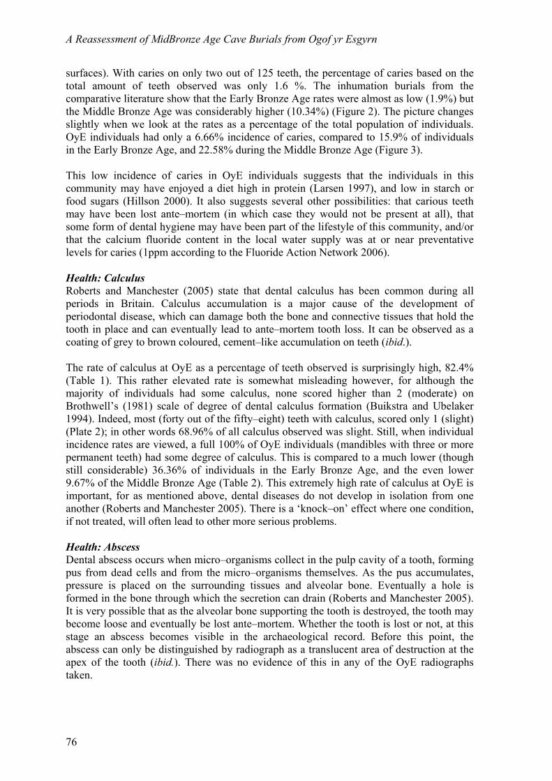
A Reassessment of MidBronze Age Cave Burials from Ogof yr Esgyrn
76
surfaces). With caries on only two out of 125 teeth, the percentage of caries based on the total amount of teeth observed was only 1.6 %. The inhumation burials from the comparative literature show that the Early Bronze Age rates were almost as low (1.9%) but the Middle Bronze Age was considerably higher (10.34%) (Figure 2). The picture changes slightly when we look at the rates as a percentage of the total population of individuals. OyE individuals had only a 6.66% incidence of caries, compared to 15.9% of individuals in the Early Bronze Age, and 22.58% during the Middle Bronze Age (Figure 3). This low incidence of caries in OyE individuals suggests that the individuals in this community may have enjoyed a diet high in protein (Larsen 1997), and low in starch or food sugars (Hillson 2000). It also suggests several other possibilities: that carious teeth may have been lost ante–mortem (in which case they would not be present at all), that some form of dental hygiene may have been part of the lifestyle of this community, and/or that the calcium fluoride content in the local water supply was at or near preventative levels for caries (1ppm according to the Fluoride Action Network 2006). Health: Calculus Roberts and Manchester (2005) state that dental calculus has been common during all periods in Britain. Calculus accumulation is a major cause of the development of periodontal disease, which can damage both the bone and connective tissues that hold the tooth in place and can eventually lead to ante–mortem tooth loss. It can be observed as a coating of grey to brown coloured, cement–like accumulation on teeth (ibid.). The rate of calculus at OyE as a percentage of teeth observed is surprisingly high, 82.4% (Table 1). This rather elevated rate is somewhat misleading however, for although the majority of individuals had some calculus, none scored higher than 2 (moderate) on Brothwell’s (1981) scale of degree of dental calculus formation (Buikstra and Ubelaker 1994). Indeed, most (forty out of the fifty–eight) teeth with calculus, scored only 1 (slight) (Plate 2); in other words 68.96% of all calculus observed was slight. Still, when individual incidence rates are viewed, a full 100% of OyE individuals (mandibles with three or more permanent teeth) had some degree of calculus. This is compared to a much lower (though still considerable) 36.36% of individuals in the Early Bronze Age, and the even lower 9.67% of the Middle Bronze Age (Table 2). This extremely high rate of calculus at OyE is important, for as mentioned above, dental diseases do not develop in isolation from one another (Roberts and Manchester 2005). There is a ‘knock–on’ effect where one condition, if not treated, will often lead to other more serious problems. Health: Abscess Dental abscess occurs when micro–organisms collect in the pulp cavity of a tooth, forming pus from dead cells and from the micro–organisms themselves. As the pus accumulates, pressure is placed on the surrounding tissues and alveolar bone. Eventually a hole is formed in the bone through which the secretion can drain (Roberts and Manchester 2005). It is very possible that as the alveolar bone supporting the tooth is destroyed, the tooth may become loose and eventually be lost ante–mortem. Whether the tooth is lost or not, at this stage an abscess becomes visible in the archaeological record. Before this point, the abscess can only be distinguished by radiograph as a translucent area of destruction at the apex of the tooth (ibid.). There was no evidence of this in any of the OyE radiographs taken.

Kare McManama-Kearin
77
There were a total of 150 visible crypt/teeth areas where abscess could have occurred in the OyE mandibles. There was however, only 1 abscess present in this collection, (seen on OyE 2 as a drainage hole located below the LPM1, Plate 3). This gives an incidence rate for abscess of only 0.8% for all teeth observed, which is very low. This rate is only slightly higher at 1.39% for the Early Bronze Age teeth compared. However, for the Middle Bronze Age the rate is considerably higher at 10.34% (Table 1).When seen as a percentage of individuals, OyE has only a 6.66% rate of abscess, the Early Bronze Age has 10.22%, with the Middle Bronze Age having the highest at 25.8% (Table 2). It is difficult to imagine what would have caused these high Middle Bronze Age abscess rates since the calculus and periodontal disease for this period are well below both the Early Bronze Age and OyE. The answer may lie in the higher percentage of caries seen in the comparable Middle Bronze Age populations, or may be related to diagnosis error (caution is required when diagnosing an abscess, as post–mortem damage can closely mimic this type of injury to the alveolar bone). Health: Periodontal disease Periodontal disease can be observed in the archaeological record in at least four ways; as porosity of the alveolar bone (specifically along the dental arcade), resorption of the alveolar bone following ante–mortem tooth loss, by the presence of calculus on the teeth and by an increased distance between the cemento–enamel junction of a tooth and the alveolar bone that supports it. However, using the cemento–enamel junction to bone measurement as an indication of periodontal disease can be misleading, since the human body will slowly and continually cause teeth to erupt in response to severe attrition (Hillson 2000, 263). This slow distancing has been acknowledged as the body’s compensatory mechanism for extreme attrition by Roberts and Manchester (2005) who suggest that an over–use of this distance from CEJ to alveolar bone may have resulted in the over diagnosis of periodontal disease in archaeological material in the past. Periodontal disease can be seen at OyE in eight individuals. Porosity is the most common observation, with five instances observed (OyE 1, 4, 6, 8 and 9). Resorption of the alveolar bone after ante–mortem tooth loss is also seen (OyE 5 and 11) and will be discussed in further detail below. It is here that for dental diseases, the ‘knock–on’ effect mentioned seems to hold true in the OyE population. For although there was not a high incidence of caries or abscesses seen, porosity, resorption and especially the high rate of calculus strongly hints that periodontal disease was a problem at OyE. Periodontal disease in the Early Bronze Age and Middle Bronze Age comparables was impossible to rate on a ‘teeth observed’ basis because, as mentioned above, teeth have been generally reported on an ‘individual observed’ basis in older studies. However, on an individual basis, the OyE collection had a 43.75% incidence of periodontal disease, compared to 17.04% during the Early Bronze Age, and 12.9% in the Middle Bronze Age (Table 2). Health: Ante–mortem tooth loss Ante–mortem tooth loss has several predisposing factors, which include trauma to the tooth, advanced age, diets rich in sucrose (Roberts and Manchester 2005) as well as all the diseases discussed above. The condition includes the resorption (or loss) of the alveolar bone which can occur across the dental arcade either horizontally, or in an irregular fashion. This can eventually cause the loss of the periodontal ligament (which holds the tooth in place) and subsequent loss of the tooth itself.

A Reassessment of MidBronze Age Cave Burials from Ogof yr Esgyrn
78
Ante–mortem loss can only really be recognized if there has been subsequent healing of the crypt. Although the OyE material is very fragmentary, five incidences of ante–mortem loss are visible (four adults and one child) and in each case a permanent molar was lost. The actual number of ante–mortem losses may have been much higher, but damage and loss of the alveolar rims on many of the mandibles makes it impossible to tell. If the percentage of ante–mortem loss at OyE were factored against the total possible tooth positions available (150 which includes both empty and full crypts) in the forty–five mandibles, it would be slightly lower at 7.33%. However to be able to compare it against the Early Bronze Age and Middle Bronze Age data, (for which the number of possible positions was not always reported) it has been calculated against the total number of teeth. When comparing total teeth observed OyE falls nearly in the centre between Early Bronze Age and Middle Bronze Age with values of 8.8% of teeth being lost ante–mortem, compared to 5.23% during the Early Bronze Age and a higher rate of 10.34% for the Middle Bronze Age (Figure 2). As mentioned earlier, the Middle Bronze Age rate of ante–mortem loss may be indicative of the higher Middle Bronze Age caries and abscess rates. On an individual basis, OyE saw 25% of the population suffering from at least one tooth lost ante–mortem, compared to 10.22% during the Early Bronze Age and 22.58% in the Middle Bronze Age (Table 2). Of the five individuals which had lost teeth while still alive, four mandibles are nearly whole, and most if not all of the positions are visible. The final individual was represented by only the left side and it is not possible to know if the right side had ante–mortem loss or not. One individual, OyE 5 had lost all of the molars bilaterally (a total of six teeth). It is important to note that this person was older, between thirty–five to forty–five years of age, and one of the four oldest individuals buried at Ogof yr Esgyrn. With age, the chances of having a dental injury, dental pathology, caries, calculus, periodontal disease, ante–mortem tooth loss, and bone resorption increase. The same holds true for another older individual, OyE 11 who lost the LM2. It is not known if this person experienced any other ante–mortem loss as only the left arcade remains, but all of the remaining teeth exhibited some level of calculus, which indicates that this particular individual may have had poor dental hygiene. OyE 9 was a little younger, between twenty–five and thirty–five years of age and had lost two molars (RM3 and LM3) ante–mortem. There was calculus of varying degrees noted on each of the nine remaining teeth, suggesting that hygiene may have played a part in the loss of this individual’s two molars as well. One young adult, OyE 2 age seventeen to twenty–five (Plate 4), had lost the RM2. This was very young to have periodontal disease, but not too young for poor hygiene to have played a role in tooth loss. An infectious disease such as caries may also have been the cause. Interestingly, this same individual was the person who had suffered the only abscess in the collection. This was in the LPM2, which had not been lost ante–mortem. It is possible that abscess had a role in the loss of the RM2, but there is no conclusive evidence. OyE 23 who lost the RM1 would have been much too young at age 9 ± 24 months to have been a candidate for periodontal disease, so caries or an accident most likely played a part in this loss. As the bone had already begun resorption at the time of death, the tooth which would have erupted between age six and seven would have only been in occlusion a relatively short time before being lost. Clearly, diet plays an important role in the overall health of every individual. Moreover, in the case of dental health, diet is integral. A diet that would have encouraged those conditions seen in the OyE collection and which might have contributed to ante–mortem
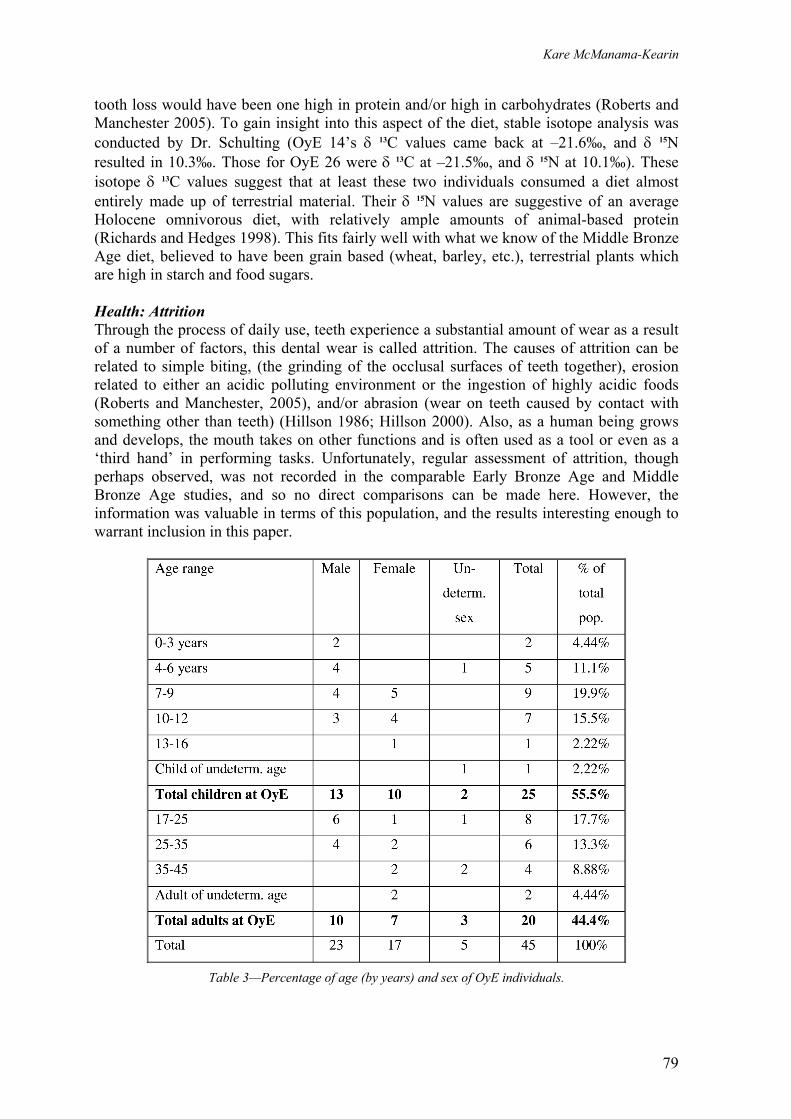
Kare McManama-Kearin
79
tooth loss would have been one high in protein and/or high in carbohydrates (Roberts and Manchester 2005). To gain insight into this aspect of the diet, stable isotope analysis was conducted by Dr. Schulting (OyE 14’s δ 13C values came back at –21.6‰, and δ 15N resulted in 10.3‰. Those for OyE 26 were δ 13C at –21.5‰, and δ 15N at 10.1‰). These isotope δ 13C values suggest that at least these two individuals consumed a diet almost entirely made up of terrestrial material. Their δ 15N values are suggestive of an average Holocene omnivorous diet, with relatively ample amounts of animal-based protein (Richards and Hedges 1998). This fits fairly well with what we know of the Middle Bronze Age diet, believed to have been grain based (wheat, barley, etc.), terrestrial plants which are high in starch and food sugars. Health: Attrition Through the process of daily use, teeth experience a substantial amount of wear as a result of a number of factors, this dental wear is called attrition. The causes of attrition can be related to simple biting, (the grinding of the occlusal surfaces of teeth together), erosion related to either an acidic polluting environment or the ingestion of highly acidic foods (Roberts and Manchester, 2005), and/or abrasion (wear on teeth caused by contact with something other than teeth) (Hillson 1986; Hillson 2000). Also, as a human being grows and develops, the mouth takes on other functions and is often used as a tool or even as a ‘third hand’ in performing tasks. Unfortunately, regular assessment of attrition, though perhaps observed, was not recorded in the comparable Early Bronze Age and Middle Bronze Age studies, and so no direct comparisons can be made here. However, the information was valuable in terms of this population, and the results interesting enough to warrant inclusion in this paper.
Table 3—Percentage of age (by years) and sex of OyE individuals.

A Reassessment of MidBronze Age Cave Burials from Ogof yr Esgyrn
80
Over one half (55.5%) of the Ogof yr Esgyrn burials are children aged 0 to 16 (Table 3) whose teeth would have experienced negligible rates of normal attrition. Even on adults, the normal attrition rates do not appear to be particularly high. However, sixteen individuals (which relates to 35.5% of the burial population) showed a form of attrition known as ‘buccal wear’ on the cusps of one or more teeth (Table 4). This is caused by the grinding down of the cusps of the tooth nearest the cheek. It may have been due to maxilla occlusion, however the corresponding maxillas were not available to examine so it is important to be open to possible behavioral factors. In certain cultures wear can be seen repeatedly on teeth in particular locations indicating habitual usage of the mouth, and particularly teeth, for a specific purpose such as tearing, pulling, or holding objects (Roberts and Manchester 2005) (Plate 5). Of the sixteen individuals with buccal wear, thirteen were children. Figure 5 demonstrates that the incidence of buccal cusp wear is highest on the deciduous second molars and next highest on the deciduous first molars.
Table 4—OyE: Incidence and locations of buccal cusp wear.
Health: Linear Enamel Hypoplasias Linear enamel hypoplasias (LEH) are enamel defects that can be macroscopically observed on teeth. Hypoplasias are important archaeologically because enamel, once laid down during development, is never remodeled. The defect will remain, captured on the tooth throughout the life of the individual and beyond. Since the process and chronology of tooth formation is well understood, measuring the distance from the enamel defect to the cemento–enamel junction can indicate the approximate period of life during which the individual was undergoing the stress that caused the hypoplasias (Goodman and Rose, 1990). This also means that individuals that experienced such stress can be recognized

Kare McManama-Kearin
81
whatever their age of death, as long as their teeth remain in the archaeological record. Because many variables contribute to the formation of hypoplasias and their exact relationships are not completely understood (Skinner and Goodman 1992; Schultz et al. 1998), it is best to regard this type of defect as a non–specific indicator of the physical and environmental problems that the individual faced while alive (Goodman 1993). Goodman and Rose (1990) suggest that populations in modern developing countries with good living conditions can be expected to have a frequency of enamel hypoplasia of approximately 10%, and that occurrence can increase as the quality of living conditions deteriorates. In areas of disadvantaged populations or populations that experience periods of malnutrition, this frequency increases even more (Larsen 1997). Unfortunately, caution must be used when comparing archaeological figures of LEH within the corpus of comparable sources used because many of the comparable Early Bronze Age and Middle Bronze Age inhumation cemeteries were excavated before hypoplasias were well understood or reliably and consistently reported. When contrasting LEH’s in observed teeth (Table 1) of OyE with the Early Bronze Age and Middle Bronze Age comparables, it is obvious that OyE, which has a rate of 21.6%, is considerably higher than the Early Bronze Age at 5.06% or the Middle Bronze Age at 5.17%. This distance is amplified when the percentages of individual occurrence are viewed (Table 2), for OyE at 53.33% is far removed from the Early Bronze Age at 15.9% and the Middle Bronze Age at 6.45%. However, this strong difference in occurrence may well be a product of developments in the archaeological understanding and identification of LEH’s and not real differences in prehistoric burial populations (Plate 6). The most common age of stress at OyE seem to have been the very earliest years. Figure 6 gives some idea of the overlapping of age ranges that LEH age of stress estimation can give. Though initially confusing, this overlapping can also be informative when the likely factors acting as stressors during these age brackets are considered. The time between birth to 2 ½ years is a period of adjustment as an infant endeavours to survive in its new environment. During this time the sole source of nutrition would probably be its mother’s milk, and a disruption to that supply from any cause such as shortage of foodstuffs, fluctuating quality of those foodstuffs and/or illness and injury to the mother can and will disturb the quality and quantity of milk available for the infant. It is not surprising then to see this period in time as one of great stress for a developing child.
Table 5—OyE: Overlapping of age ranges in LEH estimated ages of stress.
The high numbers of stresses seen between 2 ½ to 4 ½ years of age may represent the harshness of life during the weaning and post–weaning phase when a child must obtain sufficient nutrients from sources other than nursing (Roberts and Manchester 2005). This is also a time when young children are venturing out into their environment, and are exposed to physical stresses, illness and danger. Some authors (ibid.; Bush 1991) have considered the possibility that psychological stress may be responsible for hypoplasias, certainly

A Reassessment of MidBronze Age Cave Burials from Ogof yr Esgyrn
82
venturing into the life of the community could contribute to psychological stress. Whatever factors are at work here, they seem to continue through the sixth year of life. By the time, these children entered their seventh year; stress was lowered considerably and seems to have remained at low levels until it rose again just slightly again at the start of the eighth year. Clearly, these individuals’ health was not significantly affected by their childhood stress as they all lived long enough to develop enamel hypoplasias. Demographics: Age When addressing the ages of the individuals at Ogof yr Esgyrn, we see that 55.5% of the burial population were juveniles (0–16 years), and 44.4% were adults (17+ years) (Table 3). At Ogof yr Esgyrn there is a prevalence of children between the ages of seven and twelve years of age (sixteen of the total twenty–five children). Clearly, this stage of life was particularly perilous for the children of Ogof yr Esgyrn. The high number of juveniles at OyE (Figure 1), an age group normally underrepresented in the archaeological record and seldom found buried together in large numbers (as highlighted by Bruce 1986), is very unusual and is not seen in any of the comparable Early Bronze Age or Middle Bronze Age inhumation cemeteries. It is true, as Brothwell (1971) has stated that infants do not preserve well, and perhaps the dry nature of the cave and its protection from the environment and predators may account for how well juveniles are represented here.
Figure 1—OyE age ranges of all individuals.
Demographics: Sex Working with only mandibles to examine, it was not possible to sex each individual with precision. (No foolproof sexing technique is yet available for fragments of the human mandible). It should be stressed that when sexing human remains, multivariate testing is invaluable (Weiss 1973). Whenever possible it is essential to exploit several different methods and to utilize as many of the more reliable sex specific characteristics in the human skeleton as possible, for example the skull in combination with the pelvis. However, conventional multivariate testing was impossible with this collection, and so as many methods as the material would support were combined in an effort to increase the possibility of identifying the correct sex. The analysis identified twenty–three males

Kare McManama-Kearin
83
(51.1%), seventeen females (37.7%) and five (11.11%) individuals whose sex remains indeterminate (Table 3). This suggests that males and females were buried in Ogof yr Esgyrn in almost equal proportions.
Conclusion In summary, the caries rate at OyE is much lower than the comparative Middle Bronze Age data, which hints that the community may have been practicing some basic form of dental hygiene and/or (more probably) had effective levels of calcium fluoride in their diets in comparison to other Middle Bronze Age populations on the British Isles. Individuals were not, however, immune to the effects of plaque and the process of periodontal disease. Both of these conditions were considerable at OyE and may have caused decreased quality of life for those who experienced them. Abscess rates are lower at OyE than in the Early Bronze Age rates, and much lower than other Middle Bronze Age rates, and may be a reflection of the low incidence of caries at OyE. Ante–mortem tooth loss percentages at OyE are between those of the Early Bronze Age and Middle Bronze Age comparables, suggesting that the group was fairly representative of a Bronze Age population in this respect. Overall, the amount of attrition on OyE individuals would suggest well-cooked foods with only moderate amounts of abrasive substances (sand, grit). Well-cooked foods would also have benefited the health of the community as food borne bacteria are killed during the heating process of cooking. Such a healthy diet should have helped the population of Ogof yr Esgyrn to be relatively fit individuals. The final health related conclusion is that the presence of LEH’s in over a fifth of all teeth observed implies that the community experienced periods of either nutritional or physical stress. However, perhaps more telling is the absence of these defects in the majority of the teeth observed, which suggests that these times of stress may have been fairly infrequent, and/or may not have touched all levels of the community. As to the demographics we can conclude that only slightly more males than females received burial within the cave, suggesting perhaps a somewhat egalitarian community. The fact that more children than adults received burial within the cave may be due to several factors such as: the ease of carrying a small body to the cave versus carrying a larger adult body; that more youths died than adults; or that the dry nature of the cave simply preserved the remains of these children (which might otherwise have been lost to the archaeological record in another less protected burial environment), very well. Sufficient numbers of males, females, children and adults are represented at Ogof yr Esgyrn to suggest that burial privilege within the cave was easily obtainable. Unfortunately, due to the lack of information and the possibility of disturbance through time it is impossible to determine if any of the individuals received preferential burial treatment.
Further Research During the course of the literature search for comparable inhumation burials, it became obvious that a good portion of the past excavations from this period (2400 to 1130 cal BC) simply do not include full and detailed dental information. In fact, by modern standards of reporting, much vital information was not included. Unfortunately, most of the reports that did include good dental information were hampered by a lack of universal reporting standards. This is due of course to the fact that there is not a universal convention (even within the United Kingdom) for a consistent method of data presentation for dental

A Reassessment of MidBronze Age Cave Burials from Ogof yr Esgyrn
84
conditions. For this reason a recognized and standardized code of recording and reporting of dental data should be set which would include giving the teeth/tooth and crypts affected as a percentage of the total teeth/crypts available for examination (Roberts and Manchester 2005). More specific to the point of this research, it can be argued that having only two radiocarbon dates cannot convincingly place all forty–five burials at Ogof yr Esgyrn in the Middle Bronze Age. Obviously, no compelling chronological sequence for this burial population can be established without more dates. It is recommended that funding be sought for this research. Another possible area of further investigation might be a study of the levels of calcium fluoride in the water supply at Dan yr Ogof, which could help us understand the low incidence of caries at OyE. It is also suggested that microwear pattern testing could be valuable in further determining the nature and structure of this population’s diet, giving insight on many other issues from economics to cultural practices.
Acknowledgements I would like to thank Dr. Rick Schulting for the challenging assemblage with which he entrusted me, as well as for his guidance and support throughout the process of this research. I would also like to thank the people of the Dan yr Ogof Show Caves who allowed Queen’s University to examine the remains of the individuals who had been buried in Ogof yr Esgyrn. Such a spirit of scientific cooperation can greatly advance the cause of knowledge of our past heritage. Thanks also are extended to the editors of AYIA for their excellent suggestions and critiques of this article. Lastly, I have gained an appreciation for the dentists and dental technicians who are willing to put their hands in the mouths of the living and are able to work in such tight spaces. I would just like to say to them… well done all.
Bibliography Ashbee, P., Brothwell, D., Powers, R., Denston, B., Clutton–Brock, J. and Cutler, D.F. 1978.
Amesbury Barrow 51: Excavation 1960. The Wiltshire Archaeological Magazine 70/71, 1–60.
Ashbee, P., Clutton–Brock, J., Gale, R., Jewell, P.A., Keepax, C.A. and Warren, S.E. 1985. The Excavation of Amesbury Barrows 58, 61a, 61, 72. The Wiltshire Archaeological Magazine 79, 39–91.
Bellamy, P.S., Allen, M.J., Cleal, R.M.J., Jenkins, A.V.C., Maltby, J.M. and McKinley, J.I. 1991. The Excavation of Fordington Farm Round Barrow. Dorset Natural History and Archaeological Society Proceedings 113, 113–129.
Brothwell, D. R., W. Brass (ed.) 1971. Paleodemography. In Biological aspects of demography, London: Taylor and Francis, 111–130.
Brück, J. 1995. A place for the dead: the role of human remains in Late Bronze Age Britain, Proceedings of the Prehistoric Society 61, 245–277.
Bruce, M. 1986. The skeletons from the cists. In I.A.G. Shepherd (ed.), Powerful Pots: Beakers in north–east prehistory. Aberdeen: University of Aberdeen, 16–23.
Buikstra, J.E. and Ubelaker, D.H. 1994. Standards for Data Collection from Human Skeletal Remains. Fayetteville: Arkansas Archeological Survey
Bush, H. 1991. Concepts of health and stress. In H. Bush and M. Zvelebil (eds.), Health in past societies: biocultural interpretations of human skeletal remains in archaeological contexts. BAR International Series 567, Oxford, 11–21.
Butler, C., Allen, M., Cartwright, C., Gosden, T., Holgate, R. and Sanderson, E. 1991. The Excavation of a Beaker Bowl Barrow at Pyecombe, West Sussex. Sussex Archaeological Collections 129, 1–28.

Kare McManama-Kearin
85
Callender, J.G. and Low, A. 1930. Two short cists at Kilspindie golf–course, Aberlady, East Lothian. Proceedings of the Society of Antiquaries of Scotland LXIV, 191–199.
Chamberlain, A. 1997. In this dark cavern thy burying place. British Archaeology 2. Christie, P.M., Powers, R., Brothwell, D.R., Newell, R.F., Cornwall, I.W. and Kerney, M.P. 1967.
A Barrow–Cemetery of the Second Millennium B.C. in Wiltshire, England: Excavation of a round barrow, Amesbury, G.71 on Earl’s Farm Down, Wiltshire. Proceedings of the Prehistoric Society 33, 336–66.
Clark, D.V., Ritchie, A., Ritchie, G., Bruce, M.F., Kerr, N.W. and Lunt, D.A. 1984. Two cists from Boatbridge Quarry, Thankerton, Lanarkshire. Proceedings of the Society of Antiquaries of Scotland, 114, 557–558 (fiche 2:G7–14: 4: G5–14).
D’Elboux, R.H. 1924. A cave at Craig–y–Nos, Abercrave, Breconshire. Archaeologia Cambrensis 79, 113–124.
Dalland, M., McCormick, F. and Lorimer, D.H. 1991. A short cist at Grainfoot, Longniddry, East Lothian. Proceedings of the Society of Antiquaries of Scotland 121, 111–115 (fiche 1: C1–C7).
De M, F. and Vatcher, H.L. 1976. The Excavations of a Round Barrow Near Poor’s Heath, Risby, Suffolk. Proceedings of the Prehistoric Society 42, 263–292.
Donaldson, P., Kinnes, I.A., and Wells, C. 1977. The excavation of a multiple round barrow at Barnack, Cambridgeshire. The Antiquaries Journal, Society of Antiquaries of London Vol. LVII, 197–229.
Dowd, M. 2001. Archaeology of the subterranean world, Archaeology Ireland 5, 24–29. Goodman, A.H. 1993. On the interpretation of health from skeletal remains. Current Anthropology
34, 281–288. Goodman, A.H. and Rose, J. 1991. Dental Enamel Hypoplasias as Indicators of Nutritional Status,
in M.A. Kelley and C.S. Larsen (eds.), Advances in Dental Anthropology, New York: Wiley–Liss, Inc, 279–293.
Goodman, A.H., Armelagos, G.J. and Rose, J.C. 1980. Enamel hypoplasias as indicators of stress in three prehistoric populations from Illinois, Human Biology 52, 515–528.
Goodman, A.H., Rose, J.C. 1990. Assessment of systemic physiological perturbations from dental enamel hypoplasias and associated histological structures. Yearbook of Physical Anthropology 33, 59–110.
Greenwell, W. 1892. Antiquities of the Bronze Age found in the Heathery Burn Cave, County Durham,. Archaeologia: Society of Antiquaries of London 4, 87–112
Hillson, S. 1986. Teeth. Cambridge: Cambridge University Press. Hillson, S. 2000. Dental Pathology. In M.A. Katzenberg and S.R Saunders (eds.), Biological
anthropology of the human skeleton. New York: Wiley–Liss, 249–286. Howard, S. 1989. A Double Ring Ditched, Bronze Age Barrow at Barford Farm, Pamphill. Dorset
Natural History and Archaeological Society Proceedings 111, 43–54. Hurl, D. and Murphy, E. 2004. Appendix: Osteological report on human remains from
Tonyglaskan, Co. Fermanagh, and on cremated remains from Lislaird, Co. Tyrone. In D. Hurl, The excavation of a flat cist cemetery at Tonyglaskin, County Fermanagh, and of a single cist at Lislaird, County Tyrone. Ulster Journal of Archaeology 63, 20–41.
Larsen, C.S. 1997. Bioarchaeology, Cambridge: Cambridge University Press Leeds, E.T. 1938. Beakers of the Upper Thames District. Oxoniensia III, 7–27. Loth, S. R. and Henneberg, M. 1996. Mandibular ramus flexure: A new morphologic indicator of
sexual dimorphism in the human skeleton, American Journal of Physical Anthropology 99: 473–485.
Loth, S.R. and Henneberg, M. 2001. Sexually dimorphic mandibular morphology in the first few years of life, American Journal of Physical Anthropology 115, 179–186.
Mason, E.J. 1968. Ogof yr Esgyrn, Dan yr Ogof caves, Brecknock, Excavations 1938–1950. Archaeologia Cambrensis 117, 18–71.
Moorees, C.F.A. 1957. The Aleut Dentition: A correlative study of dental characteristics in an Eskimoid people. Cambridge, Mass.: Harvard University Press.
Moorees, C.F.A., 1963. Age formation by stages for ten permanent teeth, Journal of Dental Research 42: 319–328.

A Reassessment of MidBronze Age Cave Burials from Ogof yr Esgyrn
86
Mount, C. 1997. Adolf Mahr’s Excavations of an Early Bronze Age Cemetery at Keenoge, Co. Meath. Proceedings of the Royal Irish Academy 97, 1–59.
Mount, C. 1998. Five early Bronze Age cemeteries at Brownstown, Graneywest, Oldtown and Ploopluck, County Kildare, and Strawhall, County Carlow. Proceedings of the Royal Irish Academy 98C, 25–99.
Mount, C. and Hartnett, P.J. 1993. Early Bronze Age Cemetery at Edmondstown, County Dublin. Proceedings of the Royal Irish Academy 93C, 21–79.
Pryor, F. 1974. Two Bronze Age burials near Pilsgate, Lincolnshire. Proceedings of the Cambridge Antiquarian Society Vol. LXV, Part 2, 1–12.
Ralston, I.B.M., Bruce, M.F., Edwards, K.J., Gemmell, A.M.D., Kerr, N.W., Sabine, K.A., Shepherd, I.A.G. Trewin, N.H. and Warsop, C.L.M. 1996. Four short cists from north–east Scotland and Easter Ross. Proceedings of the Society of Antiquaries of Scotland 126, 121–155.
Richards, M.P. and Hedges, R.E.M. 1998. Stable isotope analysis reveals variations in human diet at the Poundbury Camp Cemetery Site, Journal of Archaeological Science 25, 1247–1252.
Ritchie, J.N.G. 1987. A cist from Kentraw, Islay. Proceedings of the Society of Antiquaries of Scotland 117, 41–45 (fiche 1: E1–8).
Ritchie, J.N.G., Stevenson, J.B., Lunt, D.A., Wickham–Jones, C.R. and Young, A. 1982. Cists at Traight Bhan, Islay, Argyll. Proceedings of the Society of Antiquaries of Scotland 112, 550–559.
Roberts, C. and Manchester, K. 2005. The Archaeology of Disease. Thrupp: Sutton Publishing Limited, 63–84.
Schultz, M., Carli–Thile, P., Schmidt–Schultz, T.H., Kierdorf, U., Kierdorf, H., Teegen, W–R, Kreutz, K. 1998. Enamel hypoplasia in archaeological skeletal remains. In Alt, K.W., Rösing, F.W. and Teschler–Nicola, M. (eds.), Dental Anthropology. Vienna: Springer, 293–311.
Schutkowski, H. 1993. Sex determination of infant and juvenile skeletons: I. Morphological features. American Journal of Physical Anthropology 90, 199–205.
Scott, E.C. 1979. Dental wear scoring technique, American Journal of Physical Anthropology 51, 213–218.
Shepherd, I.A.G. and Bruce, M.F. 1987. Two beaker cists at Keabog, Pitrichie, near Drumlithie, Kincardine and Deeside. Proceedings of the Society of Antiquaries of Scotland 117, 33–40 (fiche 1: A3–B3).
Simpson, W.G. 1976. ‘A Barrow Cemetery of the Second Millennium B.C. at Tallington, Lincolnshire’. Proceedings of the Prehistoric Society 42, 215–239.
Skinner, M.F., Goodman, A.H. 1992. Anthropological uses of developmental defects of enamel. In Saunders, S.R., Katzenberg, M.A. (eds.), Skeletal Biology of Past Peoples: Research Methods. New York: Wiley–Liss, 153–174.
Small, A., Bruce, M.F. and Shepherd, I.A.G. 1988. A beaker child burial from Catterline, Kincardine and Deeside. Proceedings of the Society of Antiquaries of Scotland, 118, 71–77 (fiche 2:E1–7).
Smith, I.F. and Simpson, D.D.A. 1966. Excavation of a Round Barrow on Overton Hill, North Wiltshire. Proceedings of the Prehistoric Society New Series, 32, 122–147.
Stuiver, M. and Reimer, PJ. 2005. RadioCarbon Calibration Program. CALIB REV5.0.2 Swärdstedt, T. 1966. Odontological Aspects of a Medieval Population from the Provinces of
Jämtland/Mid–Sweden. Stockholm: Tiden Barnangen. Ubelaker, D.H. 1989. Human Skeletal Remains. 2nd ed. Washington D.C.: Taraxacum Press. Waterston, D. 1926. A Stone Cist and its Contents Found at Piekie Farm, Near Boarhills, Fife.
Proceedings of the Society of Antiquaries of Scotland LXI 6:1, 30–41. Weiss, K. M. 1973. Demographic models for anthropology. (Memoirs of the Society for American
Archaeology No. 27). Issued as American Antiquity 38, No. Ann Arbour Mich.: Department of Human Genetics, University of Michigan, 2–49.
Internet Resources Fluoride information provided by the Fluoride Action Network: http://www.fluoridealert.org/news/2223.html

Kare McManama-Kearin
87
Appendix A: List of Comparable Literature Sources Used Amesbury 71, Wiltshire, England, Christie, 1967 (Middle Bronze Age) Amesbury 61, Wiltshire, England, Ashbee, 1978 (Early Bronze Age) Amesbury 51, Wiltshire, England, Ashbee, 1985 (Early Bronze Age) Barford Farm, Pamphill, Dorset, England, Howard, 1989 (Early Bronze Age) Barnack, Cambridgeshire, England, Donaldson, 1977 (Early Bronze Age and Middle Bronze Age) Boatbridge Quarry, Lanarkshire, Scotland, Clark et al., 1984 (Early Bronze Age) Brownstown, Co. Kildare, Ireland, Mount, 1998 (Early Bronze Age) Catterline, Kincardineshire, Scotland, Small et al, 1988 (Early Bronze Age) Dridaig Cottage, Edderton, Scotland, Ralston, 1996 (Middle Bronze Age) Edmondstown, Co. Dublin, Ireland, Mount and Hartnett, 1993 (Early Bronze Age) Fordington Farm, Dorset, England, Bellamy, 1991 (Early Bronze Age) Foxley Farm, Eynsham, Upper Thames District, England, Leeds, 1938 (Early Bronze Age) Grainfoot, Longniddry, East Lothian, Scotland, Dalland, 1991 (Middle Bronze Age) GraneyWest, Co. Kildare, Ireland, Mount, 1998 (Early Bronze Age) Keabog, Kincardine and Deeside, Scotland, Shepard and Bruce, 1987 (Middle Bronze Age) Keenoge, Co. Meath, Ireland, Mount, 1997 (Early Bronze Age) Kentraw, Islay, Scotland, Ritchie, 1987 (Middle Bronze Age) Kilspindie Golf Course, Aberlady, East Lothian, Scotland, Callender, 1929–30 (Early Bronze Age) Oldtown, Co. Kildare, Ireland, Mount, 1998 (Early Bronze Age) Overton Hill, North Wiltshire, England, Smith and Simpson, 1966 (Middle Bronze Age) Piekie Farm, Near Boarhills, Fife, Scotland, Waterston, 1926–27 (Middle Bronze Age) Pilsgate, Lincolnshire, England, Pryer, 1974 (Middle Bronze Age) Ploopluck, Co. Kildare, Ireland, Mount, 1998 (Early Bronze Age) Poors Heath, Suffolk, England, De M. and Vatcher, 1976 (Early Bronze Age) Pyecombe, West Sussex, England, Butler, 1991 (Early Bronze Age) Sandhole Quarry, Fetterangus, Scotland, Ralston 1996 (Early Bronze Age) Scotstown, Aberdeen, Scotland, Ralston, 1996 (Middle Bronze Age) Tallington, Lincolnshire, England, Simpson, 1976 (Early Bronze Age) Tavelty Farm, Kintore, Aberdeen, Scotland, Ralston, 1996 (Early Bronze Age) Tonyglaskin, Co. Fermanagh, Ireland, Hurl, 2004 (Early Bronze Age) Traigh Bhan, Islay, Scotland, Ritchie and Stevenson, 1982 (Middle Bronze Age)

A Reassessment of MidBronze Age Cave Burials from Ogof yr Esgyrn
88
Appendix B: Research Results
Table 6.a—Ogof yr Esgryn total population:Age, Sex and Teeth Present

Kare McManama-Kearin
89
Table 6.b—Ogof yr Esgryn total population: erupting, unerupted and empty crypts

A Reassessment of MidBronze Age Cave Burials from Ogof yr Esgyrn
90
Table 6.c—Ogof yr Esgryn total population: attrition, caries, abscess, AMTL.

Kare McManama-Kearin
91
Table 6.d—Ogof yr Esgryn total population: periodontal disease and calculus.

A Reassessment of MidBronze Age Cave Burials from Ogof yr Esgyrn
92
Table 6.e—Ogof yr Esgryn total population: hypoplasia and table legend
Legend Erupting and un–erupted teeth are not counted in total teeth. ? = undetermined (age or sex) Children = 0 to 12 (n=23) Child ? Years = (n=1) Adolescent = 13 to 17 (n=1) 52 total teeth on children’s mandibles 38 are deciduous 14 are permanent Adult = 17 + (n=20) OyE 14 lab. Information=
Lab # UB–6550, BP± 3008 ± 38, cal BC 1389–1129 (2σ) Using Stuiver and Reimer (2005) δ13C values were –21.6‰, δ15C values were –10.3‰
OyE 26 lab. Information= Lab # UB–6551, BP± 3008 ± 38, cal BC 1385–1128 (2σ) Using Stuiver and Reimer (2005) δ13C values were –21.5‰, δ15C values were –10.1‰
Sex determinations were made using:
Loth and Henneberg’s (1996) method of mandibular ramus flexure for adults Loth and Henneberg’s (2001) mandibular morphology in the first few years of life Schutkowski (1993) sex determination using morphognostic features
NEM = not enough material Age determinations were made using:
Ubelaker (1989) sequence of formation and eruption Brothwell (1984) wear pattern standards
Dental attrition was scored using: Scott 1979 occlusual surface wear of molars

Ian Magee
93
No Bones About It, A Skeleton Can Look Too Young For Its Age: A New Direction In The Estimation of Age–At–Death Ian Magee*
Fundamental to any osteological investigation of human skeletal remains is the estimation of age–at–death. A new method using the auricular surface of the ilio–sacral joint has been proposed by Igarashi et al. (2005), in Japan. To test this method on specimens of western ancestry, 44 auricular surfaces were tested from a sample of 25 cadavers of known age–at–death. The surface features investigated in the original study were shown to be present. However, ages were consistently and significantly under–estimated. The test was subsequently applied to 91 auricular surfaces from two archaeologically retrieved collections housed at UCC. It was concluded that the test did not significantly improve age estimation of the sample. It is suggested that social/cultural factors from the individual human experience may have a fundamental bearing on development and degeneration of the joint and auricular surface features. It was concluded, therefore, that rather than seeking to improve chronological age–at–death estimation through further refinement of statistical analysis of developmental age, it should be done through the ‘occupational age’ of the individual i.e. the physical expression of an individual’s lifetime activities as effected by their social position and cultural occupation.
Introduction In the context of osteological enquiry, what ‘age’ actually measures is twofold. Chronological age measures the amount of time the individual was alive and is measured in years for adults and, in western societies, in months for infants and in weeks for foetuses. Developmental age is different. This measures the growth of the skeleton through the process of physiological maturation. It is independent of the individual’s chronological age and is acknowledged as being influenced by biocultural factors such as diet and disease/illness. These are important indicators of population and societal health to pathological and paleodemographic analysis. Analysis of two aspects of skeletal remains categorise estimation of age–at–death. The first refers to the biological growth and development of the individual and the second to degeneration. Ironically, these confined categories define the importance of a non–specific age range in an archaeological context (though within as narrow parameters as possible). Bodies develop and degrade chronologically, influenced by complex individual genetic and cultural combinations. It is these combinations that determine the rates of maturity and their physical manifestations within individuals and populations. Consequently, it is the accurate interpretation of these combinations that has remained a persistent concern among forensic anthropologists during the past 100 years, in contributing to the overall knowledge and understanding of our ancestors.
Objectives Modern forensic and osteoarchaeological research into individual techniques for estimation of adult age–at–death continues to seek definitive points of reference in aging adult skeletal remains. Recent advances in forensic inquiry are not exclusive to either of the two disciplines, whether in development or use of methodology. Indeed, the use of both
* Department of Archaeology, University College Cork

No Bones About It, A Skeleton Can Look To Good For Its Age
94
modern and archaeologically retrieved material to achieve compatible results is at the forefront of the aims of the research presented in this paper. The research being presented represents the first application on human remains of western ancestry of a new age estimation method using the auricular surface of the ilio–sacral joint, as proposed by Igarashi et al. (2005). The objectives of this research are threefold:
• Test the multi–ethnic applicability of Igarashi et al.’s 2005 method • Establish accuracy and ease of use • Determine its usefulness in improving the accuracy of age estimation of
archaeologically retrieved adult human remains
Auricular Review The earliest observation of age–related change in the ilio–sacral joint was the recording of significant incidence of ankylosis by Brooke (1924). Ankylosis is defined by Martini et al. (2006) as an abnormal fusion in a joint as a result of friction or in response to trauma. Within a sample of 105 males Brooke recorded that 37% of his sample was ankylosed. The percentage jumped to 76% for those over the age of 50 years. Resnick et al. (1975) suggested that this increase in ankylosis might be chronologically exponential. Lovejoy, Meindl, Pryzbeck and Mensforth (1985) proposed a new method for estimating adult skeletal age at death, by observing and recording chronological changes in the auricular surface. The Lovejoy et al. (1985) method was subsequently tested by Murray and Murray (1991), Bedford et al. (1993) and Santos (1996). Whilst all of these found the study to be ‘unbiased regarding race and sex’ (Murray and Murray 1991, 1166), they also discovered a consistent underestimation of the age of older individuals by an average of 10 years, and an overestimation of younger individuals. A revised method for age estimation using the auricular surface was proposed by Buckberry and Chamberlain in 2002. They proposed that the observer would attribute numerical scores to individual features commensurate with progressive degrees of representation. A comparative test of both Lovejoy et al. (1985) and Buckberry and Chamberlain (2002), carried out by Mulhern and Jones (2004), determined that the Lovejoy et al. (1985) method was the more accurate in testing individuals from the 20–49 years of age group, and the revised Buckberry and Chamberlain method more accurate for the 50–69 years age group. Whilst they suggested that the revised method does provide an age indicator for individuals > 60 years, they recommended its use only in conjunction with other aging strategies. A further revision of the method for age estimation using the auricular surface was proposed by Igarashi, Uesu, Wakebe and Kanazawa in 2005. Igarashi et al. (2005) adopted a ‘binary classification’ whereby scores are awarded based on any presence whatsoever of the feature on an individual surface. The Igarashi method also differs somewhat from the previous methods in that an attempt to estimate age precisely replaces the previous broad ten or five year groupings. Igarashi et al. (2005) composed two models for their test. In the full model, they defined thirteen possible scoring features for males and twelve for females (Table 1). The second, reduced model contained fewer features, with the scores altered to statistically balance the

Ian Magee
95
Plate 1—Ilio–sacral joint on the os coxa enclosing the auricular surface of the ilium.
Plate 3—Auricular surface on the ilium of a 19th C specimen.
Plate 2—Auricular surface showing hyaline cartilage on surface.

No Bones About It, A Skeleton Can Look To Good For Its Age
96
absence of these features. Their results using the reduced model were slightly less accurate than those using the full model. Despite this, Igarashi et al. (2005) recommended the reduced model based on its greater ease of use. They found that percentage of their sample within the stated acceptable mean residual of 10 years (male =57.8%; female =60.8%), although quite low, was significantly more accurate than other aging techniques including ectocranial sutures, palatal sutures, the sternal rib end and the pubic symphysis (the exception being dental attrition).
Application of the Igarashi et al. (2005) Test Modern Sample There is no significant collection of archaeologically retrieved remains of known age–at–death in Ireland, and it was therefore decided to use subjects whose remains had been donated to medical schools in Ireland. Preparation of the cadavers would have had no detrimental effect on the material in the context of the test (Peter Kellaghan, pers. comm.). The subjects used were all of western ancestry. They were donor dissection specimens from the anatomy labs of University College Cork (3), Royal College of Surgeons of Ireland (16) and Trinity College Dublin (6). Subjects were ignored when fusion precluded dissection of the joint without damage to the auricular surface. If only one joint from an individual was fused, the other was still included in the sample pool. Whilst the number of individuals making up the sample is limited (25 cadavers), a precedent has been set for the use of small samples in testing methods for estimating age–at–death. Suchey’s (1979) test of the Gilbert and McKern (1973) method for aging the female pubic symphysis used a sample of only 11 with a 51% success rate. Using a sample of 739 in 1986, Katz and Suchey came to the same conclusion that the Gilbert and McKern method tended toward over–aging individuals. All subjects had recorded age at death, as well as cause of death. Because the size of the sample pool was limited, there was no specific selection process to achieve a balance of sexes nor was there any significant resultant bias toward one or the other. The males (11) ranged in age between 57– 96 and the females (14) between 66 – 101 years old at death. Age distribution is shown in Table 1. The examination was conducted as a blind test and no information regarding age or cause of death was accessed until after the test was concluded. The sample is biased toward the much older age group. Indeed the oldest subject for each sex is older than any in the Igarashi et al. test (2005) whose range was 16–89 years old for males and 11–96 for females. Those whose remains are donated to medical schools are usually in the older age range and it was necessary to use all subjects available to provide a useful sample. In total, forty–four ilio–sacral joints were used from the twenty–five subjects, six joints were not used. These either could not be separated due to complete fusion of the auricular surface, or para–auricular area, or were damaged during dissection. Results From the examination of all forty–four individual auricular surfaces, it can be confirmed that each of the features included in the Igarashi et al. (2005) test are detectable on surfaces

Ian Magee
97
of individuals of Western ancestry. The frequency distribution of features is shown in Table 1.
Feature Female
N = Male N =
Total Pearson Chi–Square
Wide Groove (WG) 9 (37.5%) 3 (15%) 12 (27.3%) .173 Striation (ST) 11 (45.8%) 14 (70%) 25 (56.8%) .135 Roughness (RO) 19 (79.2%) 18 (90%) 37 (84%) .428 Flatness (FL) 7 (29.2%) 20 (100%) 27 (61.4%) .000 Smoothness (SM) 3 (12.5%) 10 (50%) 13 (29.5%) .009 Fine Granularity (FG) 8 (33.3%) 13 (65%) 21 (47.7%) .068 Coarse Granularity (CG) 19 (79.2%) 9 (45%) 18 (40.9%) .029 Sparse Porosity (SP) 20 (83.3%) 15 (75%) 35 (79.5%) .710 Dense Porosity (DP) 11 (45.8%) 12 (60%) 23 (52.3%) .382 Dull Rim (DR) 21 (87.5%) 18 (90%) 39 (88.6%) 1.000 Lipping (LP) 10 (41.6%) 16 (80%) 26 (59.1%) .014 Tuberosity (TB) 15 (62.5%) 15 (75%) 30 (68.2%) .519 Bone Bridge (BB) 9 (45%) 9 (20.5%) – Total sample 24 (100%) 20 (100%) 44 (100%) –
Table 1—Frequency of features on modern sample surfaces and chi–square score. As a sex–pooled sample, the most commonly occurring features are DR, RO and SP, which were designated as ‘older features’ in the Igarashi et al. (2005) study. The least commonly occurring features in this sample are WG and SM. In the results of their study, Igarashi et al. (2005) concluded that WG, ST, FL, SM and FG were ‘younger features’ and that the other features were more prevalent in the older group. This pattern was observed in this study, although DP was also observed on only half of the specimens. In the male sample, the most commonly occurring feature is FL, which was present on all surfaces. With a score of 3, WG occurred least. This confirms its status as a ‘young’ feature, as it would not be expected to be prevalent in a sample of individuals as old as those used in this study. In the female sample, DR occurred in twenty–one of the twenty– surfaces (also highly represented in the male material) and SM was the least commonly occurring feature. Again, these results confirm their classifications as ‘older’ and ‘younger’ features, respectively. A chi–square test was applied to the results to test if there was any significance in the difference between feature presence and sex (P < .05). The statistical analysis of features WG, ST, RO, FL, SP, DP, DR and BB showed no significant difference in occurrence, between sexes. FG (P = 0.068) showed ‘borderline’ significance in favour of the male sample. Its true level of significance would be clarified using a larger sample. However, FF (P = 0.001), SM (P = 0.009) and LP (P = 0.014) showed a significant difference in favour of the male sample. CG (P = 0.029) showed significant difference in favour of the female sample. In the original Igarashi et al. (2005) test, initial analysis was made as a sex–pooled sample. The results from the present study, however, raise the question of the potential for cultural influence on sex–biased significance in feature development/degeneration (discussed in 5.4). The mean residual (i.e. numerical difference between the estimated age and chronological age), or Σ |estimated – actual|/N, was calculated to determine the average absolute margin

No Bones About It, A Skeleton Can Look To Good For Its Age
98
of error between the estimated age and the chronological age according to sex as well as the full pool sample. The statistical analyses were applied separately to results of application of the reduced and the full Igarashi et al. (2005) models. The results for estimation of age–at–death scores are expressed as a sex–pooled sample (n=44 auricular surfaces) as well as being divided by sex (male n=20; female n=24). As a sex–pooled sample, the full model produced a mean residual (numerical difference between the estimated age and actual age) of –19 years with the biggest residual being –38 years and the lowest being 0. The male sample provided the largest residual of –38 years (lowest +4 years), with the female sample showing a lowest of 0 and a highest of –29 years. The mean residual for the female sample was, at –16 years, below the total mean and considerably below the male mean residual of –22 years.
Male Female Sex Pool Largest error –38 –29 –38 Smallest error +4 0 0 Mean error –22 –16 –19
Table 2—Modern sample residual scores using ‘full model’.
Joint Full
0
10
20
30
40
50
60
70
80
90
100
110
120
0 10 20 30 40 50 60 70 80 90 100 110 120
actual age
estim
ated
age
FemaleMale
Figure 1—Results of application of ‘full model’.
Using the reduced model the sex–pooled sample produced a mean residual of –26 years with the highest score being –40 years (produced by both sexes) and the lowest error being 0. The male sample produced a lowest residual score of –1 with the female sample showing a lowest score of 0. The mean residual for the female sample using the reduced model was, at –20 years, not significantly below the total mean for the reduced model scores or the male mean residual score of –22 years.
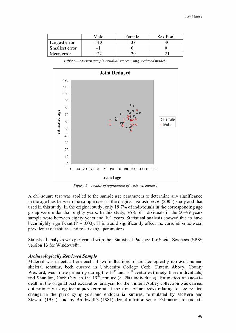
Ian Magee
99
Male Female Sex Pool Largest error –40 –38 –40 Smallest error –1 0 0 Mean error –22 –20 –21
Table 3—Modern sample residual scores using ‘reduced model’.
Joint Reduced
0
10
20
30
40
50
60
70
80
90
100
110
120
0 10 20 30 40 50 60 70 80 90 100 110 120
actual age
estim
ated
age
FemaleMale
Figure 2—results of application of ‘reduced model’.
A chi–square test was applied to the sample age parameters to determine any significance in the age bias between the sample used in the original Igarashi et al. (2005) study and that used in this study. In the original study, only 19.7% of individuals in the corresponding age group were older than eighty years. In this study, 76% of individuals in the 50–99 years sample were between eighty years and 101 years. Statistical analysis showed this to have been highly significant (P = .000). This would significantly affect the correlation between prevalence of features and relative age parameters. Statistical analysis was performed with the ‘Statistical Package for Social Sciences (SPSS version 13 for Windows®). Archaeologically Retrieved Sample Material was selected from each of two collections of archaeologically retrieved human skeletal remains, both curated in University College Cork. Tintern Abbey, County Wexford, was in use primarily during the 15th and 16th centuries (ninety–three individuals) and Shandon, Cork City, in the 19th century (c. 280 individuals). Estimation of age–at–death in the original post excavation analysis for the Tintern Abbey collection was carried out primarily using techniques (current at the time of analysis) relating to age–related change in the pubic symphysis and endocranial sutures, formulated by McKern and Stewart (1957), and by Brothwell’s (1981) dental attrition scale. Estimation of age–at–

No Bones About It, A Skeleton Can Look To Good For Its Age
100
death in the original analysis of the Shandon collection used the Suchey–Brooks method (1990) and the Lovejoy et al. method (1985). Results
Joint Full
0
10
20
30
40
50
60
70
80
90
100
0 10 20 30 40 50 60 70 80 90 100
Report Mean Age
New
Est
imat
ion S Male
S Female
T Male
T Female
Figure 3—Results of application of ‘full model’.
Male Female Sex Pool Largest error +27 +26 +27 Smallest error +1 0 0 Mean error +12.8 +8.3 +10.6
Table 4—Archaeological sample residual scores using ‘full model’. Results from the second application of the Igarashi et al. (2005) test suggest that estimates of age–at–death of previously analysed skeletal remains are not significantly improved. Whilst the residual means for the pooled sample and for each sex were much narrower than when the cadaver material was used (Table 4), estimates followed the trend of under–aging older adults and over–aging younger adults. As the mean of each original age range was used, the new residual scores can be seen as only emphasising the inaccuracy of using this method. Re–determination of Sex The circumstances surrounding the sex reassignment of S81 (from ‘probable female’ to male) provided an entirely unexpected use of the Igarashi et al. (2005) test. Whilst the scores from this individual have little significant statistical influence on the mean residual and, therefore, the efficacy of the scoring methods, the anomalous error score, does suggest that the test may have significant value as a means to determine sex in poorly preserved remains. If a test were used, therefore, that was inappropriate for one or other sex, the results would likely prove anomalous in comparison to results from tests using other anatomical points of reference, and adjustment can then be made by the investigator. In

Ian Magee
101
order to test this, the full model of the Igarashi et al. (2005) test could be reapplied to the respective opposite sex, to test for consistency of error in the estimates.
Objectives The initial question asked in this study was whether or not the features defined in the Igarashi et al. (2005) test were ethnically universal. This was shown to be the case. Similarly, the features were shown to follow the same pattern of distribution in western human remains as Asian, in terms of sex and in approximate chronology of appearance. However, the degree of accuracy in estimating age–at–death produced in the original Igarashi et al. (2005) test was not replicated using the cadaver material. It is possible that hyaline cartilage impeded observation. However, consideration must also be given to cultural activities as events in the human biological episode that can potentially influence the development and degeneration of the joint. Application of the Igarashi et al. (2005) test on archaeologically retrieved human remains proved to be convenient to implement in the laboratory. Specialised equipment is not required and the feature definitions are straightforward to interpret. This leads not only to practical advantages re time and money, but requires little training to implement. In this study, using material of estimated age–at–death did not satisfactorily test the accuracy of the original test. Results underestimated the original mean age estimates of older individuals and over estimated the original mean estimates of younger individuals. Combining the estimate–range parameter from the original analyses and the new residual errors, the total resembles the mean residual error scores achieved when the modern sample was tested. Nonetheless, to confirm any improvement in estimation of age–at–death using the Igarashi et al. (2005) method, the test ought to be reapplied to skeletal remains of known age–at–death e.g. the Hamann–Todd or Spitalfields collections. Paradoxically, because of the disparity between chronological age and developmental age (and because of cultural affects on the latter), including the Igarashi et al. (2005) test in a multiple–frame of reference would prove more useful in estimating age–at–death in archaeologically retrieved human remains.
Discussion Occupational Impact Anatomically, the ilio–sacral joint is weight bearing, acting to support the weight of the upper body and distribute it to the lower limbs. It is reasonable to assume, therefore, that either episodic or sustained vertical weight increases, or upper body activities, will impact physically on the joint and musculature in that region, not only leaving evidence of stress, but also influencing the chronological degeneration of joints in that anatomical region. It is the physical product of the mechanical function of weight transfer that the Igarashi et al. (2005) test, in part, is designed to quantify. However, there appears to have been little qualitative reference to the possible effect of cultural episodes, from the biological biography of an individual, on the ilio–sacral joint. Physical and pathological events that may impact on the joint ought also to be considered. For example, the feature ‘flatness’ was present on all of the male surfaces and yet was present on less than 30% of the female surfaces. If this feature were shown to be the result of a particular activity, or one that required certain physical attributes, inferences could be made regarding the lifetime activities of an individual, and the distribution of labour at community level.

No Bones About It, A Skeleton Can Look To Good For Its Age
102
Lifting heavy weights may lead to exaggerated pressure on the joint. Trauma (including fractures) to other skeletal parts may impact on the area of the ilio–sacral joint in terms of regional realignment through muscular and ligamental compensation (Shelley Mack, pers. comm.). Even if this does not directly affect the joint, normal overall physical function can be impaired, indirectly affecting wear on the joint. Social standing of an individual, within cultural parameters, will influence these effects. The higher the position in society, the less likely it is that the joint will be exposed to occupational trauma which might otherwise lead to accelerated bone attrition and ankylosis. Indeed the higher the social standing of the individual the more likely the opposite is true, with even more mundane daily occupation carried out by social inferiors. This is difficult to qualify from skeletally retrieved remains. Whilst the ilio–sacral joint is a region little studied by anatomists, use of cadaver material could facilitate its study and lead to a refinement of the ‘categorisation’ of features. Applying knowledge of the effect of biological and social impact on the surface of the ilio–sacral joint will likely add to the accuracy of the tests being devised to estimate age–at–death of skeletal remains. This in turn can potentially set standards for helping to identify social sub groups, under headings of occupation or social position, as well as possibly providing evidence for disease or disability that may be unavailable in archaeologically retrieved material due to taphonomic processes. Shearing As mentioned above, the joint not only supports the weight of the upper body but also transmits it to the lower limbs. Although the joint is supported by very strong ventral and anterior sacro–iliac ligaments, there is movement in it, albeit a slight degree of rotation. It has been shown that the shearing effect (movement lateral to the normal rotation) would have an effect on the joint, ‘…arising from the changing monopodal support of the pelvis during locomotion’ (Kampen and Tillman 1998). If walking can be shown to affect the joint, one must also consider the effect of other occupational, social and cultural stresses. In this study, the degree to which the joint was immobilised by the ligaments varied, exclusive of ankylosis and/or fusing. The joints of several of the samples could be quite clearly seen to move and could be partially opened prior to dissection. Samples 41TCD10MR and 42TCD10ML were the auricular surfaces from a fifty–seven year old male who had died of acute renal failure. Samples 43TCD3FL and 44TCD3FR from an eighty–six year old female who had died of ovarian cancer. Both of these specimens presented ‘non–fixed’ joints. Neither age nor sex, nor cause of death can account for this phenomenon. Biographical information was not provided in the context of this study. Consideration of any influence on the developmental age of individuals from an archaeologically retrieved sample is impaired significantly by the lack of historical and biographical information, both at an individual and at a community level. Attempts to refine methods for estimating age–at–death rely on the statistical analysis of features that are assumed to follow a shared developmental timetable. Efforts to improve the accuracy of the auricular surface method using refined statistical analysis (e.g. Bouquet–Appel and Masset 1996; Muller, Love and Hoppa 2002), ‘…do not provide the magic answer, and we could hardly expect this to be so’ (Jackes 2000:451). Indeed Jackes suggests that as little as 30% of biological changes may be actually related to natural aging processes. The apparent failure to significantly improve the accuracy of

Ian Magee
103
surface–feature based methodologies serves to highlight the difficulty in establishing a standard metric method for estimating age–at–death in samples separated temporally and spatially, further highlighting the impact of cultural/social factors. In the absence of skeletal material of known age–at–death, cadaver material represents a useful alternative when testing methods using the auricular surface of the ilio–sacral joint for estimating age–at–death. Whilst it must be acknowledged that the individuals available to medical research are rarely below the age of fifty years, creating an obvious bias toward the older age group, cadaver material has been under–utilised as a resource. Whilst the presence of hyaline cartilage can make the macro–observation of some features difficult, there remains the option to macerate the joint in the laboratory, prior to investigation. As well as recorded age at death, specimens are accompanied by recorded cause of death. This can be potentially important in determining what, if any, pathological factors may affect the joint and auricular surface. In the specimens used in this study, the individuals died of conditions that did not impact on the skeleton. However, using cadaver material provides the potential for getting information on ante–mortem pathological conditions. Osteoporosis, for example, can result in ‘…reduction in bone mass and micro–structural changes that compromise normal function…’(Martini 2006). These micro–structural changes could potentially alter the topography of the ilio–sacral joint. Crucially, cadaver material can also potentially inform as to the effects of occupational or cultural activities outside of the biological aging process, e.g. episodes from an individual’s or social subgroup’s biography which may impact on the biological aging of the individual. In previous studies, there has been little reference to the possible effects of specific cultural episodes in the biological biography of an individual, on the ilio–sacral joint.
Conclusion There is an almost predictable degree of under or overestimation, produced by methods using this joint (Cox 1996), suggesting a variable affecting the results that is exclusive of the chronological aging process, but which significantly influences developmental/degenerative aging. As seems likely the joint can be impacted on by stress or trauma, thus accelerating or retarding feature development, it would seem appropriate to include a categorisation of the features based not only on when they appear, but what caused them. This could potentially facilitate a refinement of the categorisation of the features. If a feature is exaggerated by a specific long–term occupational stress, for example, it is certain to adversely affect the estimation of age in an individual who was not involved in the occupation to the same extent, if at all. This would exaggerate the error exponentially on paleodemographic application to a larger population. A catalogue of descriptions of physical manifestations at the level of the surface features, resultant from particular activities or other biological episodes, could ultimately facilitate better paleodemographic understanding of individual, intra and inter community occupational activity. This information would be almost impossible to glean from studying human remains that do not have the accessible biography that cadaver material provides.

No Bones About It, A Skeleton Can Look To Good For Its Age
104
Therefore, rather than seeking to estimate chronological age of an individual through further statistical refinement of measurement of developmental age, this ought to be done through the ‘occupational age’ of the individual i.e. the physical expression of an individual’s lifetime activities as effected by their social position and cultural occupation. Not only would a potentially more accurate estimation of age–at–death be achieved, a ‘social age’ would provide more accurate information as to the cultural and occupational life history of individual group members. This information could then be applied to the paleodemographic biography of the community of which they were members, potentially aiding in the interpretation of our knowledge of material culture, diet and settlement patterns. This can be achieved through a bio–cultural interface between the mechanics of growth and development in the human biological experience and the cultural and social experiences that fashion that development.
Acknowledgments I would like to express my gratitude to the following: Professor John Fraher and Tracy Cuffe, Department of Anatomy, UCC, Dr Clive Lee and Peter Kellaghan, Department of Anatomy, RCSI and Mr Paul Glacken and Claire Murphy, Department of Anatomy, TCD for their hospitality, advice and support during dissection and recording of human remains in their respective anatomy laboratories; Kathleen O’Sullivan, Department of Mathematics and Statistics, UCC, for lifting the fog of statistical analysis.
Bibliography Bedford, M.E., Russell, K.F., Lovejoy, C.O. Meindl, R.S., Simpson, S.W. and Stuart–Macadam,
P.L. 1993. Test of the multifactorial aging method using skeletons with known ages–at–death from the Grant collection. American Journal of Physical Anthropology 91, 287–297.
Bocquet–Appel, J.P. and Masset, C. 1996. Palaeodemography: expectancy and false hope. American Journal of Physical Anthropology 99, 571–583.
Brooke, R. 1924. The sacro–iliac joint. Journal of Anatomy 58, 299–305. Brooks, S.T. and Suchey, J.M. 1990. Skeletal age determination based on the os pubis: a
comparison of the Ascadi–Memeskeri and Suchey–Brooks methods. Human Evolution 5, 227–238.
Brothwell, D.R. 1981. Digging up bones. Ithica: Cornell University. Buckberry, J.L. and Chamberlain, A.T. 2002. Age estimation from the auricular surface of the
ilium: a revised method. American Journal of Physical Anthropology 119, 231–239. Cox, M. 1996 Life and Death in Spitalfields. York: Council for British Archaeology. Gilbert, B.M. and McKern, T.W. 1973. A method for aging the female os pubis. American Journal
of Physical Anthropology 38, 31–38. Igarashi, Y., Uesu, K., Wakebe, T., and Kanazawa, E. 2005. New method for estimation of adult
skeletal age at death from the morphology of the auricular surface of the ilium. American Journal of Physical Anthropology 128, 324–339.
Jackes, M. 2000. Building the bases for paleodemographic analysis: Adult age determination. In Katzenberg, M.A. and Saunders, S.R. (eds.), Biological Anthropology of the Human Skeleton. New York: Wiley–Liss. 417–466.
Kampen, W.U. and Tillman, B. 1998. Age–related changes in the articular cartilage of human sacroiliac joint. Journal of Anatomy and Embryology 198, 505–513.
Katz, D. and Suchey, J.M. 1986. Age determination of the male os pubis. American Journal of Physical Anthropology 69, 427–435.
Lovejoy, C.O., Meindl, R.S., Pryzbeck, T.R. and Mensforth, R.P. 1985. Chronological metamorphosis of the auricular surface of the ilium: A new method for the determination of adult skeletal age at death. American Journal of Physical Anthropology 68, 15–28.

Ian Magee
105
Martini, F.H., Timmons, M.J. and Tallitsch, R.B. 2006. Human Anatomy. San Francisco: Pearson and Benjamin Cummings.
McKern, T.W. and Stewart, T.D. 1957 Skeletal age changes in young American males, analysed from the standpoint of identification. Natick: Headquarters Quartermaster Research and Development Command.
Mulhern, D.M. and Jones, E.B. 2004. Test of revised method of age estimation from the auricular surface of the ilium. American Journal of Physical Anthropology, 126(1), 61–65.
Muller, H.G., Love, B. and Hoppa, R.D. 2002. Semiparametric method for estimating paleodemographic profiles from age indicator data. American Journal of Physical Anthropology 117, 1–14.
Murray, K.A. and Murray, T. 1991. A test of the auricular surface aging technique. Journal of Forensic Science 36, 1162–1169.
Resnick, D., Niwayama, G. and Goergen, T. 1975. Degenerative disease of the sacroiliac joint. Investigative Radiology, 10, 608–621.
Renfrew, C. and Bahn, P. 1996. Archaeology: theories, methods and practice. London: Thames and Hudson Ltd.
Santos, A.L. 1996. How old is the pelvis? A comparison of age at death estimation using the auricular surface of the ilium and os pubis. In Pwiti, G. and Soper, R. (eds.), Aspects of African archaeology. Papers from the 10th Congress of the Pan African Association for prehistory and related studies. Harare: University of Zimbabwe.
Suchey, J.M. 1979. Problems in the aging of females using the Os pubis. American Journal of Physical Anthropology, 51(3), 467–70.


Catriona McKenzie
107
A General Overview of Pathological Lesions Noted During the Osteoarchaeological Analysis of the First Two Hundred Skeletons from the Medieval Cemetery Site at Ballyhanna, Co. Donegal Catriona McKenzie*
The Ballyhanna skeletal collection was excavated in 2003/2004. It was a rescue excavation, which was conducted by I.A.C Ltd. prior to the construction of the N15 Bundoran– Ballyshannon bypass in County Donegal. At Ballyhanna, a large medieval human skeletal collection was excavated from a cemetery, which is thought to have been in use between 1100AD–1400AD. The collection consists of a total number of 1259 individuals; of these 840 are adult individuals and a further 419 are sub–adult individuals. This is one of the largest medieval cemeteries excavated in Ireland to date. The presence of males, females and children indicate that this cemetery was probably a communal graveyard for all members of society. Furthermore, the historical evidence suggests that the individuals from Ballyhanna are likely to represent that of a native Gaelic population as opposed to an Anglo–Norman population. The majority of individuals at the Ballyhanna cemetery were buried in the traditional Christian position; extended, supine, and orientated E–W with the head positioned in the west. This paper will outline some of the interesting and unusual pathological and traumatic lesions that have been observed on the Ballyhanna skeletal collection to date
Introduction The townland of Ballyhanna is located approximately one mile to the southeast of Ballyshannon in County Donegal. In 2003–2004 Irish Archaeological Consultancy Ltd. excavated a large cemetery site at Ballyhanna. Over one thousand two hundred and sixty individuals were recovered from the cemetery site. Of these, approximately eight hundred and forty are adult individuals, both male and female, and a further four hundred and twenty skeletons are those of subadults. The demographic profile of the skeletal population suggests that this was a communal burial ground for all members of society. Furthermore, it is likely that Ballyhanna was a Christian burial ground as the skeletons were predominantly buried in the traditional Christian position; supine, extended, and orientated east–west. This skeletal collection is thought to be one of the largest medieval Gaelic populations excavated in Ireland to date. The human remains were excavated from a relatively small area measuring only 40m x 50m. Although the skeletons vary in completeness (there was extensive truncation of burials by later graves) the skeletal preservation is generally very good. At present, the only evidence for dating the cemetery site comes from artefactual evidence. Long cross silver pennies and ha’pennies found in situ during the excavation and dating to the reign of Henry III (1251AD–1276AD) and Edward I (c. 1280 AD–1302 AD) suggest that the cemetery at Ballyhanna was probably in use between 1100–1400 AD (Ó Donnchadha 2006, 20). Osteoarchaeological analysis of the Ballyhanna skeletal collection is ongoing. In conjunction with Ms. Róisín McCarthy, the adult skeletons are currently being assessed macroscopically. Standard osteoarchaeological techniques (see Brickley and McKinley * School of Geography, Archaeology and Paleoecology, Queens University Belfast

A General Overview of Pathological Lesions Noted at Ballyhanna, Co. Donegal
108
2004) are being applied to the adult skeletons to estimate, sex, age–at–death and stature. Information on osteometrics, non–metric traits and any evidence of trauma or pathological lesions, which may be evident on the bones, are also being recorded in detail. The subadult individuals will be examined by Dr. Eileen Murphy (Queen’s University Belfast) in due course and the data collected will be combined with that from the adult skeletons in the final interpretation. The aim of this paper is to present a general overview of some of the pathologic and traumatic lesions evident on the first two hundred adult skeletons analysed. For the purposes of this paper, pathological changes are discussed under the following headings: dental diseases, trauma, joint disease, infectious disease, metabolic disease and neoplastic disease. This data is part of ongoing research, which aims to adopt a biocultural approach in the analysis and interpretation of the skeletal population from Ballyhanna. A biocultural approach combines primary data from the analysis of the skeletal material with secondary data; documentary; archaeological and iconographic evidence. Adopting a biocultural approach will allow the interpretation of the biological data to take all of the following aspects into consideration in the interpretation: the geographical location, environmental influences, material culture, settlement and housing conditions, industry, diet, and economy of the study population. This research will facilitate a greater understanding of the health, diet and lifestyles in a rural medieval Gaelic population. The results from Ballyhanna will then be placed into a broader context by comparing the data from the Ballyhanna collection with other Irish and British medieval skeletal populations. Dental Diseases Teeth frequently survive archaeological excavations relatively undamaged due to the hard enamel structure. Analysis of the dentition may provide invaluable information about the health, diet, occupation, physiological stress and dental hygiene practiced by an individual from the skeletal population (Roberts and Manchester 2005, 63). The presence of a dental disease in an individual may predispose the individual to a secondary dental disease; therefore, dental diseases often do not occur in isolation. For example, in Figure 1 an abscess, ante–mortem tooth loss (AMTL) and periodontal disease are all apparent on the maxilla. Dental diseases are the most frequently observed pathological lesions evident on the Ballyhanna skeletons analysed to date. Commonly recorded dental diseases include: calculus; dental caries; abscesses; periodontal disease; AMTL; enamel hypoplasia and dental attrition. Each of these will be outlined below. Calculus Dental calculus is the calcification or mineralisation of living plaque deposits which attach to the surface of the tooth (Hillson 2002, 255). Figure 1 shows dental calculus (light brown in colour) on the second right maxillary molar. In the Ballyhanna population, calculus is frequently recorded. A high prevalence of calculus may suggest a ‘high protein and/or carbohydrate diet’ (Roberts and Manchester 2005, 71), as these food types produce an alkaline environment in which the disease flourishes. In addition, a high prevalence of dental calculus may also suggest that dental hygiene was not being widely practiced as the removal of living plaque deposits prevents the formation of dental calculus. Dental Caries Dental caries are recorded as opaque spots or cavities on the dental enamel (Hillson 2002, 269). Caries are often located in between the fissures on the crown of the tooth or at the cemento–enamel junction between the crown and root of the tooth. These lesions are

Catriona McKenzie
109
caused by demineralisation of the tooth due to acid by–products of plaque bacteria through the ‘fermentation of food sugars, especially sucrose in the diet’ (Roberts and Manchester 2005, 65). A high prevalence of dental caries may indicate a diet, which has a high component of carbohydrates or sucrose. In general, dental caries are more prevalent in modern populations than in archaeological populations. This is due in part to modern diets that contain higher levels of refined sugar. Before the 16th century, sugar would not have been widely available to the majority of the population (Roberts and Manchester 2005, 68). As a result, there are relatively low rates of dental caries recorded in British and Irish populations before the post–medieval period (Roberts and Cox 2003). In the Ballyhanna population, dental caries are occurring more frequently than would normally be expected in a medieval population. The prevalence of dental caries may be of particular interest if this rate is reflected throughout the entire skeletal collection. Dental Abscess Although dental abscesses have been recorded on the Ballyhanna skeletons there has been a low prevalence rate on the dentitions analysed to date. Dental abscesses are caused by a build up of pus which exerts pressure on the alveolar bone thereby creating a sinus through which the pus can drain away (Roberts and Manchester 2005, 70). It is the presence of this sinus, which is evidence that the individual had a dental abscess during life. In Figure 1, an abscess is present on the maxilla located at the root of the second maxillary right molar. In clinical cases, dental abscesses often cause severe pain prior to drainage. Periodontal Disease and Ante–mortem tooth loss A build up of dental plaque may cause inflammation of the gums at the cemento–enamel junction between the dental crown and the root of a tooth. In severe circumstances, the inflammation may spread to the alveolar bone. Tooth sockets are located in the alveolar bone and so it is an integral part of supporting healthy teeth during life. If an inflammation spreads from the gums to the alveolar bone the bone reacts by resorbing and this, therefore, leaves the tooth roots exposed (Hillson 2005, 305). This process is known as periodontal disease. In cases of severe periodontal disease the alveolar bone is resorbed substantially, which may result in AMTL. In Figure 1 there is resorbed alveolar bone apparent at the site of the first right maxillary molar. The first right maxillary molar is missing a result of AMTL, evidenced by remodelling around the edges of the tooth socket. Periodontal disease is rarely exhibited on the Ballyhanna skeletal collection, however, AMTL is recorded relatively frequently. This may be because AMTL is multifactorial in aetiology; for example, trauma, abscesses, dental caries or periodontal disease may cause it. Enamel Hypoplasia Enamel hypoplasia may be described as a non–specific indicator of physiological stress. Physiological stress can occur during periods of malnutrition or dietary stress, trauma, disease, infection or illness (Buikstra and Ubelaker 1994, 56). Factors such as these may affect the formation of the teeth in childhood, causing dental defects such as lines, pits or grooves to develop on the enamel surface of teeth. These defects occur while the tooth is forming and remain on the tooth enamel into adulthood. Ethnographic studies have shown that there is a strong correlation between dietary stress and the formation of enamel hypoplasia in childhood (see Hillson 2002, 166 for examples). So far, there have been very few instances of enamel hypoplasia recorded on the adult dentitions of the Ballyhanna skeletal collection.

A General Overview of Pathological Lesions Noted at Ballyhanna, Co. Donegal
110
Figure 1—Right mandible and maxilla showing calculus, an abscess, periodontal disease and ante–mortem
tooth loss
Figure 2—Cranial trauma on the left occipital and parietal bones
Figure 3—Vertebral compression fracture

Catriona McKenzie
111
Dental Attrition Lastly, dental attrition is the wear that naturally occurs on teeth as a result of chewing or masticatory stress. This may be due to eating or using the teeth as tools for technological purposes; for example to work leather. Dental attrition is recorded on the occlusal (or biting) surface of the tooth. The rates of dental attrition are relatively severe in the Ballyhanna population. This may provide an insight into the preparation of food that was being consumed. Frequently, in past populations where there are high levels of dental attrition, this may be due to small pieces of gravel, sand and stone being inadvertently included in the food during preparation, prior to consumption (Roberts and Manchester 2005, 78). The use of medieval quern stones to grind grain would have undoubtedly resulted in small inclusions of grit and sand in the food. These inclusions are often the reason for increased dental wear seen in archaeological populations, as they accelerate the rate of wear on the teeth. In cases of severe dental attrition the pulp cavity can become exposed which predisposes the tooth to other dental diseases such as dental abscesses and dental caries. Trauma Examination of trauma is important as it may provide essential information about lifestyles, occupation and environment of the study population. Trauma is defined as an acute physical injury or wound that affects the tissues of the body. It is commonly identified in archaeological skeletons through the presence of fractures, dislocations or deformations. Of these three categories, only fractures have been identified in the Ballyhanna skeletal population analysed to date. Fractures may be caused by acute trauma, recurring stress or as a result of underlying pathological conditions. The extent of healing at fracture sites is also important to note as it may indicate information about diet, medical intervention and possible related complications (Cox and Mays 2000, 338). Weapon Injury One probable male individual, SK 325, almost certainly died as the result of a single sharp force blow to the cranium (Figure 2). This was probably caused by an edged blade; the result of interpersonal violence. There was no evidence of healing around the edges of the lesion, suggesting that the trauma occurred peri–mortem. The lesion is situated on the left occipital and parietal bones crossing the midlambdoid suture. This may indicate that SK 325 received the blow to the back of the cranium from a right handed opponent who was positioned behind him when the blow was delivered. Unfortunately, only the cranium was present for osteoarchaeological analysis, so it was not possible to identify any other injuries, which this individual may have received. A further three cases of sharp force cranial trauma are evident on the skeletons analysed to date. All the blows are single and seem to be caused by an edged blade, for example a sword. Fractures In the cases of fractured long bones, the site of union is often very well healed with little evidence of displacement, infection or associated joint complications. This may indicate that medical intervention was perhaps common, for example, in setting fractures. In one case however, on the left femur of a young individual, SK 939, a severe infection was evident. The bone infection caused osteomyelitis at both ends of the probable compound fracture. In this instance, the localised osteomyelitis was a secondary complication. The severity of the bony changes suggest that the individual must have managed to fight the

A General Overview of Pathological Lesions Noted at Ballyhanna, Co. Donegal
112
secondary infection, however the site of the fracture remained separated and so the leg in question would not have been able to withstand any weight applied to it. On two individuals analysed there are cases of vertebral trauma evident in the form of compression fractures (Figure 3). Vertebral fractures are commonly caused by one of two processes. Firstly, repeated mechanical stress can cause the vertebrae to fracture and compress. This is common among those who are involved in heavy physical lifestyles. Secondly, vertebral fractures may be caused by weakening of the bone quality due to an underlying disease process such as tuberculosis or osteoporosis. Once the bone quality has been compromised by a primary disease, everyday actions such as lifting and coughing may result in traumatic vertebral fractures. Joint Disease The most frequently occurring joint disease in the Ballyhanna skeletal collection is spinal degenerative joint disease. Degenerative joint disease is often most prominent in the weight–bearing areas of the body; the spine, hip and knee joints. With increasing age, degeneration and deterioration of bone quality becomes commonplace. A joint surface may become remodelled as a result of one (or both) of two processes: formation of new bone or destruction of the remaining bone. Three lesions in particular are often indicative of spinal degenerative joint disease – eburnation, osteophyte growth and Schmorl’s nodes. Eburnation occurs when the cartilage between two adjacent bones is worn away and the two elements come into direct contact. Without the protective joint cartilage, movement causes the bones to rub against each other. This produces a characteristic worn, polished appearance on the bone at the articular surfaces, known as eburnation (Mays 2002, 127; White 2000, 398). In severe cases, the eburnation, over a period is not only polished in appearance but grooves may form where the two bones are in continual contact at the joint. New bone formation is a common response to degenerative joint disease in the spine. In the vertebrae osteophytes, which are nodules of new bone, are often caused by degeneration of the intervertebral discs, which culminates in irritation at the margins of the vertebral body. This irritation stimulates the periosteum to form osteophytes to increase the joint surface and thereby reduce the stress on the joint (Buikstra and Ubelaker 1994, 121; Mays 2002, 127). In cases where there is severe stress in the spine it is possible for the vertebrae to fuse together, thereby fixing the joint and preventing further movement or irritation at the affected joint. To date this process, known as ankylosis, has only occurred in one individual from the collection. Schmorl’s nodes are caused by degeneration of the intervertebral disc, which protrudes through the vertebral surface facing the disc and extends into the vertebral body (Buikstra and Ubelaker 1994, 121). This produces a characteristic indentation in the corresponding vertebral body (Figure 5). The specific aetiology of Schmorl’s nodes is unknown; different factors, such as trauma or an underlying disease process such as osteoporosis may weaken the bone structure thereby contributing towards the development of Schmorl’s nodes. Clinical cases indicate that individuals affected by spinal degenerative joint disease would have been likely to suffer from sporadic backache and stiffness. These lesions are common in older individuals who are naturally affected by deterioration in bone quality with increasing age. Nonetheless, the three lesions indicative of degenerative joint disease have

Catriona McKenzie
113
Figure 6—Osteomyelitis on the left femur
Figure 7—Porotic Hyperostosis
Figure 8—Cribra Orbitalia

A General Overview of Pathological Lesions Noted at Ballyhanna, Co. Donegal
114
been recorded in individuals as young as 17–25 years of age from the Ballyhanna skeletal collection. This supports the theory that degenerative joint disease may also be a mechanically induced condition, caused by bending and lifting during everyday activities. If it is found to be commonplace among younger individuals this may indicate that those affected were partaking in heavy physical labour as opposed to sedentary work. Infection An individual can suffer from a specific infection in which the causative organism is known, (for example, tuberculosis which is caused by a variety of mycobacteria, but most commonly mycobacterium tuberculosis or mycobacterium bovis) or a non–specific infection in which the causative organism is not known. Periostitis and osteomyelitis are both examples of a non–specific infection. Periostitis is commonly recorded on the skeletons analysed to date. It is an inflammation of the periosteum caused by trauma or infection (White 2000, 392). Periostitis is evident as reactive, woven, plaque–like bone affecting only the cortical bone. Osteomyelitis is a more severe bone infection. It can be caused by a localised infection or by a generalised primary infection. The diagnosis of osteomyelitis is generally unproblematic as the infection exhibits distinctive pathological lesions whereby the bone becomes enlarged and deformed. Three processes contribute towards osteomyelitis; bone destruction, pus formation and simultaneous bone repair (Roberts and Manchester 2005, 168). Often a bone affected by osteomyelitis will have one or more sinuses in it, through which pus filled abscesses drain into the surrounding body tissue. Non–specific Infection Figure 6 shows a severe case of osteomyelitis on the left femur; the entire bone shaft and proximal epiphysis are affected by the infection. This infection is non–specific and could have been caused by either a general infection or a localised infection. A general infection such as an ear, throat, sinus or chest infection may cause disease–producing bacteria to be transported through septicaemia: a blood infection from the primarily affected area. This could have resulted in the severe bone infection of the left femur. Alternatively, the osteomyelitis in this case could have been caused by a localised infection for example, through a leg ulcer. Although the cause of the osteomyelitis in this case will probably remain unknown, clinical cases of osteomyelitis indicate that this individual would probably have been seriously ill with fever, pain and immobility in the lower limb. However, the presence of the chronic bony lesions indicates that this individual must have survived the acute phase of the infection. In medieval Gaelic Ireland, in the pre–antibiotic era, there would have been a high mortality risk if an individual suffered from a severe infection. Specific Infection So far, the only evidence for specific infection is a suspected case of tuberculosis. As highlighted, tuberculosis is an infectious disease commonly caused by Mycobacterium tuberculosis or Mycobacterium bovis. Skeletal changes caused by the tuberculosis infection are relatively uncommon; occurring in as little as 5–7% of cases in the pre–antibiotic era (Aufderheide and Rodríguez–Martin 1998, 133). The spine is the most common location to find lesions that may indicate tuberculosis. It has been estimated that the spine is affected in 50% of all cases of the infection, which have skeletal involvement (Aufderheide and Rodríguez–Martín 1998, 135).

Catriona McKenzie
115
Bony lesions, which may aid in the identification of spinal tuberculosis in skeletal material, have been described in detail by Aufderheide and Rodríguez–Martin (1998), Ortner (2002) and Roberts and Manchester (2005). The main characteristics include: lesions primarily located in the lower thoracic and upper lumbar vertebrae; destructive lytic lesions that produce cavities in the trabecular bone frequently with little or no new bone formation; weakening of the trabecular bone which may lead to collapsed vertebrae and kyphosis (anterior bending of the spine); and lastly, usually between one and four vertebrae are involved. Biomolecular studies have, through the study of ancient DNA, confirmed the osteological diagnosis of tuberculosis in a number of cases (see Mays et al. 2001 for examples). These studies have highlighted that positive identification of tuberculosis in skeletal material is possible through the careful examination of pathological lesions. SK 882 is that of a probable female individual aged between 35–45 years of age at time of death. Malignant lytic lesions found on the vertebrae of SK 882, with no evidence of healing, suggested a diagnosis of tuberculosis. There were no vertebral fractures present on SK 882; however, this is likely to be because of extensive bone resorption. The degree of kyphosis on SK 882 was not recordable due to the fragmentation of the vertebrae, but observations of the individual vertebrae suggest that the degree of kyphosis was likely to have been very severe. In addition to the vertebral lesions, the presence of periostitis on the ribs may also be considered additional evidence for a pulmonary disease such as tuberculosis. Modern clinical symptoms for all forms of chronic tuberculosis include fever, fatigue, night sweats, loss of appetite and loss of weight. In addition, symptoms of pulmonary tuberculosis also include coughing, chest pains, and production of blood stained sputum. This female individual would have been very sick and debilitated. The spinal lesions and kyphosis would have caused an obvious physical spinal deformity. Considering the severity of this disease process, it is likely that this individual received some form of support and/or care during the illness.
Metabolic Disease Porotic Hyperostosis Of the crania that are present there has been a relatively high rate of porotic hyperostosis. It is evident as symmetrically distributed porotic lesions, which may be present on the frontal and/or parietal, and/or occipital bones (Figure 7). In addition to the porotic lesions, the diploë bone (found between the inner and outer table of the cranial vault) becomes thickened (Stuart–Macadam 1991, 101). Although the specific aetiology of porotic hyperostosis is unknown, it has been widely proposed that these changes may be caused by anaemia and in particular by acquired iron–deficiency anaemia (Stuart–Macadam 1991, 101; Mays 2002, 142). It is thought that these lesions occur as the result of the body being stimulated to produce more red blood cells in the marrow to compensate for lack of iron. Nonetheless, there is evidence that other nutritional deficiencies such as vitamin C and D deficiencies may cause similar lesions. Roberts and Manchester (2005) therefore proposes that porotic hyperostosis lesions should not be viewed solely as characteristic of a specific metabolic disease but rather a non–specific indicator of a number of metabolic diseases. Cribra Orbitalia A similar lesion located in the orbits of the frontal is named, cribra orbitalia (see Figure 8). There is evidence to suggest that both cribra orbitalia and porotic hyperostosis are formed by the same nutritional deficiencies; the two processes often occur together. Lesions found

A General Overview of Pathological Lesions Noted at Ballyhanna, Co. Donegal
116
on the cranial vault may indicate a more severe form of anaemia than those apparent in cribra orbitalia. Although cribra orbitalia is usually more common in a population than porotic hyperostosis this does not seem to be reflected in the Ballyhanna skeletal collection. On the skeletons analysed to date, there has been a higher proportion of individuals affected by porotic hyperostosis than cribra orbitalia. Neoplastic Disease Metastasised neoplastic lesions are cancerous lesions, which are found on secondary sites throughout the skeleton. The cancer has spread from the original soft tissue tumour via cells transported by the bloodstream or lymphatic system (Mays 2002, 127). Metastasised lesions are usually found at sites, which have high contents of trabecular bone: the vertebrae; pelvis; sternum and cranium. Aufderheide and Rodríguez–Martín (1998) highlight that some primary cancers are more likely to cause metastasised lesions than others: these include prostate cancer and breast cancer. Some metastases are osteoblastic (bone forming), forming spicules of new bone growth, whilst other metastases are osteolytic (bone destroying). Metastases from prostate cancer are usually osteoblastic while those from other primary cancers such as lung, thyroid and kidney cancer are usually osteolytic. Breast cancer can produce both bone forming and bone destroying metastases. One individual from Ballyhanna has been identified as having nine neoplastic lesions evident on the cranial vault (Figure 9). The skeleton is that of a female individual who was a young adult between 18–35 years of age at time of death. Both osteoblastic and osteolytic metastases are present on the cranial vault. Although the primary site of the cancer is not often predictable, the presence of bone forming metastases in this young female may suggest that the primary cancer was breast cancer.
Figure 9—Metastasised lesions
Conclusion The purpose of this paper was to provide a brief overview of some of the common and unusual pathologies and traumatic lesions that have been recorded on the Ballyhanna

Catriona McKenzie
117
skeletal collection to date. This data however, refers only to the first two hundred skeletons analysed and it is likely that patterns and trends seen in the data will change as the sample size increases. The Ballyhanna skeletal collection is unique in that it is a large Gaelic population. Much of the previous work on Irish medieval skeletal populations has tended to focus on groups, which would have been influenced by incoming populations, including the Anglo–Normans. Therefore, the data and interpretations generated as a result of this research will hopefully provide a greater understanding of the lifestyles, diet, health and economy of a large medieval Gaelic population.
Acknowledgements I would like to thank the following for their help throughout the ongoing research: the National Roads Authority who are providing the funding for this research as part of The Ballyhanna Research Project and my supervisors, Dr. Eileen Murphy (QUB) and Dr. Colm Donnelly (QUB) for their help and guidance. In addition, I would like to thank the project academic partners in the Institute of Technology in Sligo: Dr. Jeremy Bird, Dr. Ted McGowan and in particular Róisín McCarthy, the Project Research Assistant and Osteoarchaeologist, who is assisting with the data collection.
Bibliography Aufderheide, A.C. and Rodriguez–Martin, C. 1998. The Cambridge Encyclopaedia of Human
Palaeopathology. Cambridge: Cambridge University Press. Brickley, M and McKinley, J. (eds.), 2004. Guidelines to the Standards for Recording Human
Remains, available at http://www.soton.ac.uk/~babao/archive.html Brothwell, D. R. 1981. Digging up Bones. (3rd edn.). New York: British Museum and Cornell
University Press. Buikstra, J.E. and Ubelaker, D.H. (eds.), 1994. Standards for Data Collection from Human Skeletal
Remains. Arkansas Archaeological Survey Research Series No.44. Arkansas: Arkansas Archaeological Survey.
Cox, M and Mays, S (eds). 2000. Human Osteology in Archaeology and Forensic Science. London: Greenwich Medical Media Ltd.
Hillson, S. 2002. Dental Anthropology (3rd edn.). Cambridge: Cambridge University Press. Hillson, S. 2005. Teeth (2nd edn.). Cambridge: Cambridge University Press. Mays, S. 2002. The Archaeology of Human Bones (4th edn.). London: Routledge. Mays, S., Taylor, G.M., Legge, A.J., Young, D.B. and Turner–Walker, G. 2001.
Palaeopathological and biomolecular study of tuberculosis in a medieval skeletal collection from England. American Journal of Physical Anthropology 114, 298–311.
Ó Donnchadha, B. 2006. N15 Bundoran to Ballyshannon Stage 2 archaeological services stratigraphic report. Unpublished report for Irish Archaeological Consultancy Ltd.
Ortner, D. J. 2002. Identification of pathological conditions in human skeletal remains (2nd edn.) San Diego: Academic Press.
Roberts, C. and Cox, M. 2003. Health and Disease in Britain; From Prehistory to the Present day. Gloucestershire: Sutton Publishing.
Roberts, C. and Manchester, K. 2005. The Archaeology of Disease (3rd edn.). Gloucestershire: Sutton Publishing.
Stuart–Macadam, P. 1991. Anaemia in Roman Britain: Poundbury Camp. In H. Bush and M. Zvelebil (eds.), Health in Past societies: Biocultural interpretations of human skeletal remains in archaeological contexts. BAR International series 567, 101–113.
White, T.D. 2000. Human Osteology. London: Academic Press:.


Sara Nylund
119
The Landscape of Mottes in Co. Louth: Topography, Location and Function Sara Nylund*
Motte and baileys are generally associated with the Anglo–Normans in Ireland, and occur throughout the country. The majority of these castle sites occupy dominant positions within the landscape. One of the clear objectives of the motte builders was to see and be seen. However, scrutiny of the distribution of these monuments reveals other trends that hint towards the defined and specialised usage of this versatile structure. These uses can be explored through study of the motte’s structural composition and location in the landscape. This paper will specifically explore the c. 30 mottes and baileys in modern day Co. Louth. It will assess the influence different terrain types in Louth (fertile plains and drumlin) had on motte construction, and identify the variations evident between large caput sites such as the examples in Dundalk and Drogheda and the smaller frontier mottes. In addition, other locating factors, such as the positioning of mottes to control key routeways, will be suggested with reference to historical sources from the medieval period. It will be argued that the location and intended purpose of the motte and bailey often bore a direct influence on the type of structure constructed.
Background When the Anglo–Normans arrived in Ireland, their first priority was to consolidate and strengthen their claim on the holdings they had acquired. They identified key sites to fortify, often with tremendous views of the surrounding countryside. The principal tool employed in this castle building was the Norman motte: a man made mound with a timber castle atop it, often with one or more baileys attached to the mound. These were raised enclosures, which gave the motte support by providing an area for habitation, storage and additional defence (Sweetman 1999, 11). Mottes can still be identified today, beside old route–ways and on strategically significant points in the landscape. The practice of establishing strongholds in key locations is a strategic concept, as through siting mottes at key points, the castles could play many different roles. They often acted as a garrison and administrative centre for the surrounding countryside. Some had a pronounced military aspect, with substantial baileys for support. These protected the borders of Anglo–Norman expansion and were often one in a chain of similar castles positioned along the frontier (McNeill 1997, O’Keeffe 2000). Others had a less glamorous role as watch–posts and were used to monitor the movement of goods and people. The functions of mottes are diverse. These structures were the medieval equivalent of a ‘flat pack’ castle and were relatively easy to construct. Consequently, they were immensely adaptable to different forms of terrain and function. The distribution of these monuments displays trends, which suggest a refined and pre–conceived usage of this versatile structure. No motte survives today with its wooden superstructures intact, but the uses they were put to can be explored through study of the motte and baileys extant earthworks and structural composition, as well as their location in the landscape (e.g. Higham and Barker, 1992). By examining the location of the monuments, with reference to medieval sources, it will be argued that the intended function of the motte and bailey influenced the location and form of the structure. The study will examine thirty mottes and baileys in Co. Louth. It will assess the influence of terrain and identify variations between the large caput sites and the smaller frontier mottes.
* Headland Archaeology Ltd

The Landscape of Mottes in Co. Louth
120
Figure 1—The spread of motte and baileys in Co. Louth (based on the Archaeological survey of Co. Louth). Figure 2—The Topography of Co. Louth (based on the Archaeological survey of Co. Louth).
Figure 3—The medieval roads in Co. Louth, based on Bradley’s map on medieval routes and army movements (Bradley 1992; Nylund 2004). Figure 4—The spread of mottes in Ireland in relation to high ground and drumlins.

Sara Nylund
121
Table 1—The motte and baileys of Co. Louth
Historical Setting The Anglo–Normans arrived in Ireland in 1169 as mercenaries, principally from the Welsh Marches. The most famous of them was Richard de Clare, ‘Strongbow’, recruited by Diarmait Mac Murchada, as a means for him to regain his kingship in Leinster and expand his interests in Ireland. Through his marriage to Diarmait's daughter Aoife, Strongbow inherited the lands of Leinster. Concerned by the expanding power of his subjects in Ireland, Henry II came to the country in 1172–3 to ensure the seed of rebellion was not growing. During his campaign, he granted land and estates to his followers and received homage from the Irish Kings. It does not seem that any part of modern day Co. Louth, then within the Kingdom of Airgailla, was under any significant Anglo–Norman influence at this juncture (Lydon 1972, 51) Although the objectives of the motte builders in Co. Louth were essentially the same as in the rest of the country, the circumstances under which the region was colonised appears to have had less to do with military prowess than shrewd political manoeuvring. The century preceding the Norman arrival had already introduced many changes, with the Fir Fernmaige adding today's Co. Louth to their Kingdom of Airgailla (Smith 1999, 13). These new rulers, led by Donnach Ua Cerbaill, seem to have been quite dynamic, instituting a number of reforms including an attempt at a more feudal structure (Smith 1999, 19). Donnach worked hard at reforming the church, introducing new religious orders and granting lands to both the Augustinians and the Cistercians. He used the new traditions connected with feudalism to his advantage, through handing out grants to the church of lands in strategic locations, thus creating buffer zones between himself and his enemies. This political ability also enabled Donnach to expand his territory (Smith 1999, 19–20).

The Landscape of Mottes in Co. Louth
122
When Donnach died in 1168 his son Murchad came to power. Murchad took part in the war against the English and participated in an attack on Dublin in 1171. Later the same year, Murchad submitted to Henry II, but was again among those attacking Hugh de Lacy and destroying Trim castle in 1174 (Smith 1999, 25). It is conceivable that Murchad felt his position threatened by Hugh de Lacy, the major landholder in Meath, as castles were constructed in several places like Kells, Skreen, Navan, Nobber and Slane. Raids were launched from these castles, which threatened Ua Cerbaill territory, as their strategic centre around Louth in particular sustained damage. There are indications that these Anglo–Norman raids could have been contrary to a bargain struck between Murchad Ua Cerbaill and Hugh de Lacy, as the sources refer to "treacherous" raids on Ua Cerbaill territory between the years of 1177–78 (Otway–Ruthven 1968, 70). Murchad may have decided to ally himself with the English (and de Lacy in particular) because he did not believe the native Irish Kings remained powerful enough (Smith 1999, 25). Whatever the circumstances, Murchad either accepted or allowed the Anglo–Normans to move onto his territory, or it may be the case that he was unable to successfully oppose Anglo–Normans settling on his lands before his death (Smith 1999, 20). Ireland received another royal visit in 1185, when Prince John arrived to tour his Anglo–Norman territories. Although no major territorial expansions were made during this time, the English Crown implemented considerable administrative changes. This move was primarily aimed at preventing ambitious and militarily successful lords such as de Lacy and de Courcy from gaining too much power and control in Ireland (Lydon 2003, 67). It seems there was little organised opposition to the Anglo–Normans and the area consisting of contemporary Louth was parcelled out, with the main benefactors being the families of de Verdun and Pippard. The reason for these grants was to create a buffer between de Courcy in Ulster and de Lacy in Leinster, in a bid to prevent them sharing Louth between them and joining in an alliance that could have threatened the supremacy of the King in Ireland (Smith 1995, 29). The Verdun and Pippard families, alongside other smaller grant holders, turned out to be a wise choice as landholders in Co. Louth. They set about consolidating the territory they ruled through fortification of the county, until the Bruce invasion in the 14th century, after which their power started to wane (Orpen 1968, 197).
The Topography of Co. Louth Co. Louth is enclosed to the south and west by Co. Meath, with Co. Monaghan to the northwest, Co. Down to the north, and a small area of Co. Armagh bounding the county in the north–north–west. Although the smallest county in Ireland, it displays a wide topographical variety, with evidence for extant mottes on differing terrains. A plain extends from Dunleer in the south to north of Dundalk and from the coast, west to Co. Meath. This plain represents the largest part of the county and consists of gently rolling hills that provide a good view of the surrounding landscape. The fertile plain gives way to the more broken countryside of drumlins to the northwest, and this topographical change represents the frontier of the Anglo–Norman colony in Co. Louth (Buckley and Sweetman 1991, 214). Around the town of Ardee is an area of bog, which may be that referred to during the twelfth to fourteenth centuries as "the great bog" (Aalen, Whelan and Stout 1997, 112). The north of Co. Louth consists of the foothills of the Slieve Gullion range with passes leading to the north, which were guarded by various mottes during the Norman period. One of the few parts of the county not to contain many mottes is the Cooley peninsula. This is perhaps due to the fact that it consists principally of mountains; generally the motte builders seem to have preferred to stay in the vicinity of good

Sara Nylund
123
agricultural land. The highest points in Louth–Carlingford Mountains, Angelsea, Clermount Carn and Barnave, all lie in the northern part of the county within this peninsula (Lyons, 2007). The main rivers in the county include the Boyne running from Co Meath through Drogheda, the Mattock, which flows along the Louth–Meath Boundary, and the Kilcurry, Cully, Fane and Castletown rivers which all flow into Dundalk Bay. There are three other rivers, the Glyde, by Castlebellingham, the Dee by Ardee and the White River by Dunleer. All the major rivers are overlooked by a motte on at least one point of their course, showing the significance of rivers for transport and communication during the Anglo–Norman period. Other important topographical factors are bays and harbours–Carlingford Bay lies between counties Down and Louth, while Dundalk Bay would have been a major port during medieval times (Lyons 2007).
The Towns and Routeways The major towns of Louth when the Anglo–Normans arrived in the 12th century have not changed from the ones we can see on the map today, with Drogheda, Ardee, Louth, Dunleer and Dundalk the most important. Whilst the Anglo–Normans might not have established these towns, they certainly prioritised them for fortification. Drogheda and Dundalk would have been the largest and most influential settlements, due to their position on important junction points for maritime, riverine and land based travel (Graham 1985, 29). Drogheda was an important crossroads for north– south communication, as well as inland along the Boyne. Dundalk was in a similar situation, with several of the major rivers running into Dundalk Bay, which provided good anchorage for ships (Gosling 1991, 320). Of the other towns, Dunleer seems to have been located at a crossroads, suggesting the presence of a marketplace, as the meeting of several routes would have been very favourable for trade (Hindle 1982). In the case of Louth town, we know there was a castle held by Anglo–Normans there before 1196; since this is the year contemporary sources refer to the town and castle being burned by Niall Mac Mathghamhna and John de Courcy. The town of Louth was also the strategic centre of the Kingdom of Airgailla (Smith 1999, 23). A network of smaller and more substantial roads and track–ways would have interconnected the major towns and smaller villages. Sadly, the exact routes of most of these roads are hard to discern today. There are, however, two major medieval routes known in Co. Louth; one runs from Dundalk to Drogheda, while the other route runs between Drogheda–Ardee–Louth–Dundalk (Bradley 1992, 63). The Dundalk–Drogheda route is documented on the Down survey map (1657), and there are also scattered references to a medieval road from Dundalk to Drogheda in a number of different sources (Bradley 1992, 64). Another possible routeway, which ran from Drogheda through Ardee and Louth to Dundalk, is less well documented. The route however can be speculated by examining military troop movements during the 14th Century in Louth, where the Royal and Scots army were manoeuvred during the Bruce invasion. In order to move armies as large as the Bruce and the Royal forces, roads would have been needed to support the ‘train’, such as horses, supplies, wagons and everything else needed to maintain an army both on the march and whilst encamped. The destinations of these armies have been well researched by historians (e.g. Duffy 2002, 12). The armies operated between Drogheda, Ardee, Louth and Dundalk, suggesting the presence of a major routeway to facilitate this. There is a strong possibility that any major roads extant in the 14th Century may well have existed in the 12th and 13th Centuries. Subsequent analysis of the mottes in the area confirmed the probability of this routes existence, with a number of fortifications placed along it (Nylund 2004, 47).

The Landscape of Mottes in Co. Louth
124
The medieval roads depicted in Figure 3 are based on the Down Survey map of confirmed medieval roads (Bradley 1992, 65) and the description of the Bruce and Royal army movements in Co. Louth in the 14th century (Nylund 2004, 35). When these two pieces of research are combined, they reinforce the evidence for an Anglo–Norman tendency of building mottes near routes of movement.
Evaluating Mottes in Co. Louth There are thirty–one known mottes in Co. Louth (See Figure 1 and Table 1). The only examples that have been archaeologically investigated are Lurgankeel, excavated in 1964 by the OPW, although yet to be fully published (Rynne and Ó hÉochaodhe 1965) and Greenmount, which was excavated in the nineteenth century, by Major–General J.H. Lefroy (Lefroy 1871). The latter excavation yielded finds such as animal bones, a bronze axe, a bone harp pin and a bronze plaque with a runic inscription. At the time it was believed the earthwork was a Viking burial mound. The only other study of mottes was their survey for the Archaeological Survey of Co. Louth (Buckley and Sweetman 1991). The principal research strategy employed for this study included analysing data on the mottes location and structure. This was achieved through examining the results provided by earlier research. By assessing the structure of motte mounds according to McNeill’s 1:2 ratio of height versus width (thereby allowing calculation of the mounds probable original dimensions), we can get an indication as to whether the mounds have been quarried or otherwise disturbed after they have fallen in disuse (McNeill 1980). Factors such as the Anglo–Norman preference for good viewpoints and control over communications, as well as their intense fortification of frontier areas, were all considered to achieve an understanding of the preferred terrain upon which to construct the castles, and what circumstances might have prompted them to do so (Bradley 1992; Cunnigham 1987; McNeill 1997). The resources the Anglo– Normans preferred to secure included large settlements, marketplaces, churches or ports. Landscape and terrain were not excluded; fertile areas suitable for agriculture and rich pasture seem to have been highly favoured for settlement. Other areas targeted for castle building were favourable strategic locations, such as in close proximity to fords, navigable rivers, possible roads or crossroads. Previous studies of excavated mottes in Ireland and the UK have demonstrated that the principal buildings were sited inside the defences, with topographical concerns dictating the shape and plan of the internal structures to a greater extent than tradition or comfort (Higham and Barker 2000, 170). Generally motte builders seem to have preferred agriculturally rich land and avoided mountainous areas. This could have been to do with practicalities, as to build a mound a good supply of topsoil was needed. Recent research has suggested that the amount of soil available was a factor that influenced the siting of a motte or a ring–work castle. A shallow soil layer would have prevented the construction of mounds, leaving areas with thinner topsoil devoid of mottes. In contrast, ring–work castles required less soil in order to become defensible, and could have been constructed as a substitute in this type of terrain (Prior 2006, 129). Whilst this is an intriguing theory, it is yet to be substantiated through detailed study in Ireland. If geography was solely responsible for the large areas of the Anglo–Norman
Sara Nylund
125
colony seemingly devoid of motte mounds, there should be more mottes in the south and southwest of Ireland, as conditions are favourable for mounds in areas around Limerick and Cork. This would indicate that there were other factors influencing these locations. One such factor has been suggested by O’Keeffe, who points out that the colony was a patchwork of different lordships, each with different settlement agendas (O’Keeffe 2000, 33).
Anglo–Norman Strategy and Motte Placement Mottes were used as a tool for consolidating and holding on to the Anglo– Norman areas of conquest throughout Ireland. By building a fortified base on their newly acquired land, the Anglo–Normans maximised the impact a relatively small force could have on the surrounding area. Possessing a secure base had a positive impact on morale, as well as providing a defensible shelter and reliable provisions (Prior 2006, 26). Current research on castle–studies has found that an area subjected to Norman expansion went through roughly three stages during the colonisation process. The first stage was to establish their presence in the area, fortifying themselves in the most strategic point in the landscape, from which they could control supply lines, communication and the native population. The second stage was to control the native trade, villages, towns and the administrative function of the area. Finally, as the Anglo–Normans settled they would have assumed full control of all aspects of the economy and politics of the area (Prior 2006, 26). Mottes in Co. Louth can be clustered into two main groups and one sub–group. These comprise mottes sited along routeways and along the frontier, with a sub–grouping of mottes in major settlements. There are shared characteristics between the groups, but diverse features can also be discerned. It can therefore be argued that the different groupings were constructed with different functions in mind (Nylund 2004, 34). The few dates we have for the construction of mottes in Co. Louth indicates that the major centres were targeted first, as these provided the prime location for a power base. This facilitated domination of the surroundings and provided a good base for further expansion. Immediately upon this development, there followed a bid to advance and strengthen the borders of the settler’s holdings. The final phase saw additional castles constructed to provide a comprehensive network across the county, representing a continuing programme of fortification witnessed throughout the Anglo–Norman occupation. Each of the groupings will now be examined, in order to explore their different attributes and characteristics (See Table 1).
Mottes and Routes of Movement Mottes sited along routeways are a mix of large and impressive examples with baileys, and smaller, lone structures. The common denominator is their proximity to, and control of, a road, ford or waterway. While mottes in Louth have not previously been studied in detail, their inclination to concentrate on routes of movement has been noted in other parts of the country, for example the midlands, where the mounds of mottes are a common site (Cunningham 1987). In Co. Louth, fifty percent of surviving mottes are positioned to oversee either major rivers or roads. This number excludes mottes found in major settlements, which tend to possess many of the same characteristics as those on route–ways. However, for the purpose of the study, they were treated as a separate class, as they performed additional duties. If they are

The Landscape of Mottes in Co. Louth
126
included in the calculation, the percentage of mottes sited along routes of movement is sixty–six percent.
Figure 5—Mottes related to route–ways and major settlements in Co. Louth.
Mottes on routeways range in height from 4 m – 8.7 m. Most of these would have boasted excellent views over the surrounding area and could have controlled movement on the routes they covered. Of the fifteen mottes connected to routeways (Figure 5), forty–seven percent possess baileys and are slightly higher than those examples that lack one. The mottes missing a bailey do not seem to distinguish themselves from the ones with a bailey in any way. Some have obvious supporting settlements, such as at Piperstown, which is situated beside a deserted medieval village (Barry 2000, 113). Others guard possible fords, as is the case with Stephenstown and Castlecarragh. A number of the routeway mottes were not in an area with a known route. However, the quantity of medieval routes in Co. Louth is unknown and as the mottes in question display all the characteristics of mottes on routeways, they have been included in the group. One such example is Dellin, a possible motte and bailey recorded only as a crop–mark. It may have been connected to the medieval road from Dundalk to Drogheda, but it seems to be situated too far inland for this to be the case (Orpen 1968, 125). Dromin, on the other hand, is situated on a bend of the River Dee, once again highlighting the Anglo–Norman desire to oversee and control routes of movement. The same applies to Drumcashel, which in its heyday would have commanded a good view of the surrounding landscape, probably overlooking the course of the river. The site at Drumcashel is today overgrown and it is difficult to estimate the extent of the original line of sight.

Sara Nylund
127
Mottes and Major Centres Caput mottes connected to major settlements are situated at Drogheda (Castletown motte), Dundalk (Lagavoreen motte), Louth (Artoney motte), Ardee (Dawson’s Demesne motte) and Dunleer (See Figure 5). These were the first fortified sites when the Anglo–Normans colonised the area of modern day Co. Louth. By fortifying these hubs, or major settlements, the Anglo–Normans created secure bases from which they could encourage the construction of defensive fortifications, thus strengthening, protecting and extending their land grants surrounding the settlements, and ultimately the Anglo–Norman colony as a whole (McNeill 1997, 67).
Figure 6.—Derrycammagh motte, approaching from the south.
Figure 7—The substantial mound of Lagavoreen motte, with a Martello tower constructed on the summit.

The Landscape of Mottes in Co. Louth
128
Mottes in major settlements tend to be slightly larger than others, being the caput (chief castle and permanent residence) of the family holding the area. They almost certainly combined several different roles, such as functioning as a garrison in times of unrest and having administrative and political functions for the surrounding community (Graham 1985, 16). They also had to be defensible against a sizeable force, as the castle would have been at the strategic centre of the Anglo–Norman land grant, and therefore prime targets. This group of mottes displays the highest mounds, which would have enhanced their status as a major caput and centre for the local lord. These substantial motte mounds range from 7 m – 11 m in height, with three of the five mottes possessing baileys. The two exceptions are Castleguard and Dunleer. The former is the highest settlement motte, and may lack a bailey because the settlement itself sustained it and its domestic needs, or alternatively it may have been destroyed before it was recorded. Dunleer seems to have started out as a motte belonging to the routeway category, later evolving in function due to its central position on a routeway junction, which during the Middle Ages often meant the difference between a settlement prospering or deteriorating (Hindle 1982, 41). Lagavoreen and Castletown are most likely the earliest mottes to be built in Co. Louth, and remain the most imposing today. A golden ring, which is now on display in the medieval exhibition in the National Museum of Ireland, Kildare St, was found in proximity to Castletown motte in Dundalk, and is indicative of the high status function it performed.
Figure 8—Motte distribution on the Frontier.
Frontier Mottes According to McNeill (1997) and Prior (2006), the function of frontier mottes was to guard the borders of the Anglo–Norman colony. As Figure 4 demonstrates, they are generally situated in drumlin–country or on the foothills of mountainous areas, which is more undulating terrain than the plains of central Co. Louth (McNeill 1997, 67; Prior 2004, 193). Frontier mottes were the second consideration of the Anglo–Normans and key frontier

Sara Nylund
129
locations were fortified almost concurrently with those mottes in major settlements. This frontier line continued to be strengthened throughout the history of the Anglo–Norman colonisation. Roesia de Verdun, holder of Castletown, in Dundalk, is recorded to have built castles on the frontier in 1230, adding more fortifications to this area of uneven terrain (Smith 1999, 45). The mottes on the Anglo–Norman border in Co. Louth follow the trend of frontier mottes in other parts of the country. These structures are larger and display a higher occurrence of baileys than the mottes on routeways further into the colony. In Co Louth, eighty percent of frontier mottes are recorded with this additional defence. The castles needed the capacity to hold a garrison, to be able to quickly respond to any threat that might arise in the area and to withstand a possible siege. Frontier mottes would have been utilitarian and mounds in this category are generally slightly lower than those in major centres, which were built to impress and dominate (Nylund 2004, 39). Frontier mounds range in height from 3m at Lurgankeel to 8.8m at Killanny. Lurgankeel might seem quite low from a defensive point of view, but its military ability was increased by the presence of a second mound (Rynne and ÓhÉochaodhe 1965). Along the western border of Co. Louth and in Co. Meath the edge of the drumlin–belt follows the edge of the motte frontier, while in the north of Co. Louth the foothills of the Slieve Gullion range contain a concentration of mottes. Perhaps the most remarkable thing about this defensive line is that it stretches across different Anglo–Norman land grants and through Meath, which was occupied before Co. Louth, forming a cohesive line (McNeill, 1997, 67). It is also of note that this frontier line of mottes peters out further to the southwest. This dense line of mottes formed a defensive arc to protect the heart of the Anglo– Norman settlement, with the topography dictating the siting of mottes along the frontier. It would seem more than coincidence that this frontier line coincides with the start of more rugged country.
Figure 9—A typical view from the summit of a motte.
Their construction was influenced by specific strategic and tactical needs rather than the personal whim of individual grant–holders. This explains why these frontier mottes are concentrated in a line stretching over different grants and why they continued to be located in the same areas. To be able to wield the same amount of control over uneven terrain and

The Landscape of Mottes in Co. Louth
130
stop possible raids into their territory, the Anglo–Normans had to situate those mottes in drumlin country closer to each other. These circumstances point to the conclusion that even though the extent and the spread of the mottes represents the extent and spread of Anglo–Norman settlement, the size and placement (and to some degree density) of the fortifications is principally dictated by the more undulating topography closer to the frontier (Nylund 2004, 47). A further example of this can be seen on the coast and the plains of Co. Louth, where the mottes are smaller and built further from each other. In this area, the topography tends to be quite flat with gentle slopes rather than steep hills. As a result of this, it was possible for the Anglo Normans to keep the mottes more widely spaced, as they would still have been able to view a large portion of their surroundings (possibly with some degree of intervisibility between them) thus exerting control over the landscape (Nylund 2004, 45).
Conclusion Mottes were a versatile and useful structure for the Anglo–Normans to construct when they arrived in Ireland. Although cheaper to erect than the stone castle, it was not seen as an inferior castle, but as a handy and flexible alternative, which could be adapted to almost any terrain or strategic needs. Whether they were placed on major or minor grants, it is clear the mottes tend to concentrate on routes of movement or centres of settlement. Whilst all these fortification had a military aspect, the frontier mottes clearly had a slightly more active role in peacekeeping and enforcing the borders of the colony than those in settlements and along routeways. Mottes were often sited in close proximity to pre–existing settlements, or reused pre–existing sites such as ring–forts in their construction. There are six examples in Co. Louth of possible souterrains found within the mound of the motte. This can be viewed as an attempt by the Anglo– Normans to appropriate the locality, replacing Gaelic Irish fortifications and centres with their own. A further example of this Anglo–Norman attempt to control their surroundings can be seen in their response to the undulating landscape of the frontier. They chose to place castles closer together to minimise the amount of ‘dead ground’. Further into the county the landscape allowed for a better line of sight, resulting in the mottes being more spread out. This analysis of mottes in Co. Louth reinforces the idea that the Anglo–Normans established a hold on the landscape through fortifications, but takes it further to show that they built their castles according to specific needs. The intention of this article is to highlight the value of region specific studies relating to mottes. Through a combination of geographical, historical and archaeological sources, research can elucidate the different uses of mottes in an area, and allow theories to be formulated regarding the reasons for their siting and construction. It is to be hoped that this paper has indicated that the Anglo– Normans did not throw up castles randomly around the countryside with the sole desire of keeping down the native population. Rather they carefully selected their sites, using the versatility of the mottes to construct regional centres, control trade and trade routes, and defend what they had won.

Sara Nylund
131
Acknowledgements Thanks to Damian Shiels, without whose help and support I would still only be contemplating publishing an article, and to the AYIA for giving me the forum and opportunity to do so.
Bibliography Aalen, F.H.A, Whelan, K. and Stout, M (eds.) 1997. Atlas of the Irish Rural Landscape. Cork:
Cork University Press. Barry, T. 2000. Excavations at Piperstown deserted medieval village, Co. Louth, 1987.
Proceedings of the Royal Irish Academy 100C, 113–135. Buckley, V. and Sweetman, D. 1991. Archaeological Survey of County Louth. Dublin: The
Stationery Office. Cunningham, G. 1987. The Anglo–Norman advance into the South–West Midlands of Ireland
1185–1221. Roscrea: Parkmore Press. Duffy, S. (ed.) 2002. Robert the Bruce’s Irish Wars. The invasions of Ireland 1306–1329.
Gloucestershire: Tempus. Gosling, P. 1991. From Dún Delca to Dundalk: the topography and archaeology of a medieval
frontier town AD c.1187–1700. Journal of the County of Louth Archaeological and Historical Society, 239–353.
Graham, B.J. 1985. Anglo–Norman settlement in Ireland. Athlone: Temple printing. Higham, R. and Barker, P. 1992. Timber Castles. London: Stackpole books. Higham, R. and Barker, P. 2000. Hen Domen Montgomery. A timber castle on the English–Welsh
border. Exeter: University of Exeter Press. Hindle, P. 1982. Medieval Roads and Tracks. Buckinghamshire: Shire Publications Ltd. Lefroy, J.H. 1871. On a bronze object bearing a runic inscription at Greenmount, Castlebellingham,
Co. Louth. Journal of the Antiquarian Society in Ireland, 471–502. McNeill, T. 1997. Castles in Ireland, Feudal Power in a Gaelic world. London: Routledge. McNeill, T. 1980. Anglo–Norman Ulster. Edinburgh: John Donald. Nylund, S. 2004. The Mottes in Co. Louth – A reappraisal of their classification. Unpublished MA
Thesis, University College Dublin. O’Keeffe, T. 1996. Rural settlement and cultural identity in Gaelic Ireland, 1000–1500.
RURALIA I, 142–151. O’Keeffe, T. 2000. Medieval Ireland: An Archaeology. Gloucestershire: Tempus. Orpen, H. 2005. Ireland under the Normans 1169–1333. Dublin: Four Courts Press. Otway–Ruthven, A.J. 1968. A History of Medieval Ireland. London: Barnes and Noble. Prior, S. 2006. A few well positioned castles. The Norman Art of War. Gloucestershire: Tempus. Smith, B. 1999. Colonisation and Conquest in Medieval Ireland. The English in Louth 1170–1330.
Cambridge: Cambridge University Press. Sweetman, D. 1999. The Medieval Castles of Ireland. Cork: Collins Press. Internet Resources Unpublished excavations: Lurgankeel, Albany, Co. Louth: www.heritagecouncil.ie/archaeology/unpublished_excavations/section 18.html Rynne, E. and ÓhÉochaodhe, M .1965 Entered 19.06.2007 From Ireland: (http://www.from–ireland.net/descrs/lout/louthdescr.htm) Lyons, J. Entered 15.06.2007


Paul O’Keeffe
133
Approaches to Battlefield Archaeology in Ireland: A Case Study of the Siege and Battle of Kinsale AD 1601 Paul O’Keeffe*
It was 1601 and Ireland was in its seventh year of bloody warfare. Despite many victories, the Irish alliance, lead by Hugh O’Neill and Red Hugh O’Donnell was now faltering. The Crown forces under Lord Deputy Mountjoy formed an ever–tightening ring around their northern strongholds, it seemed only a matter of time before O’Neill, and O’Donnell’s bitter struggle came to an inglorious end. October 1601 however brought new hope. Spanish galleons sailed into Kinsale harbour, and with them came the promise of victory. The events of the following three months, culminating in an Irish rout at Kinsale, are a story familiar to us all. It is one of the great “what if’s” of Irish history. Yet, what do we really know about it? Where are the extensive English fortifications that formed such a tight stranglehold over the town for three months? Where are the Spanish trenches that held such a superior force at bay for so long? Where, indeed, was the final battle actually fought? These are the questions that the Kinsale Battlefield Project set out to investigate. Through our primary research of contemporary cartographic and documentary sources, combined with landscape analysis and metal detection survey, we believe we now have some answers.
Introduction Battlefield archaeology is the study of ancient and historic conflict, including not only large–scale battles but also sieges, skirmishes and all manner of minor engagements. It is the application of archaeological principles to a body of evidence often so ephemeral that it was, until relatively recently, deemed unworthy of scientific investigation. The prevalent view amongst archaeologists was that nothing could be gained from the study of battlefields apart from “the salvage of relics” (Scott et al. 1989, 10). Thus, the study of human conflict has remained the near exclusive domain of the historian. As one would expect, the historian confines his/her research to the extant historical record, sifting through its inherent biases and inaccuracies in order to arrive at a generally acceptable version of events. However, no matter how astute and vigorous the critique applied to such records, it cannot wholly compensate for their innately subjective nature. This is particularly true of eyewitness accounts pertaining to past conflict. Battle by its very nature is chaotic and distressing, inducing levels of fear, hysteria and violence far beyond the normal range of human emotion. This alone precludes its individual participants from giving an objective account of the event. Even the calm and controlled veteran can only honestly describe what occurred on his particular part of the battlefield. All that may realistically be hoped for is an overview of the battle, normally provided by a leading figure from one faction or the other (Sutherland 2005, 4). This in itself of course does not constitute an objective account but rather a highly subjective interpretation (ibid.). Battlefield archaeology has the potential to redress this imbalance. By subjecting sites of past conflict to rigorous archaeological investigation an independent data set can be compiled which, unlike the historical record, is based solely on scientific retrieval of the surviving physical evidence (Foard 2004, 14). Combined with an array of analytical techniques from such fields as military history and historical geography (among others) a truly objective, and often radically different, interpretation of a particular battle or site of conflict can be ascertained.
*NRA Assistant Archaeologist, Mid West region

Approaches to Battlefield Archaeology in Ireland
134
The History of Battlefield Archaeology Although there has long been a strong tradition of military history in most cultures, very few of its practitioners could be viewed as the forerunners of today’s battlefield archaeologists. This is largely due to the dominance of the narrative tradition within military history and its tendency to focus almost exclusively on historical sources to provide a rather linear interpretation of particular battles or campaigns (Keegan 1978). Interest in the battlefield itself rarely extended beyond an attempt to ascertain its location (Carman 2005, 216). A notable exception was the work of Edward Fitzgerald on the battlefield of Naseby (Northamptonshire, AD 1645) in the mid–nineteenth century. He approached the battlefield in much the same way as the battlefield archaeologist does today, treating it as a research tool in its own right and recording field names, find spots and topographical features. He also conducted test excavations, in the course of which he succeeded in locating a mass grave (ibid.). The 1970’s witnessed a major leap forward with the pioneering field walking survey conducted by Peter Newman at the Marston Moor battlefield (AD 1644) in North Yorkshire (Sutherland 2005, 14). However, it was a bushfire in 1983 on the Little Bighorn National Monument, USA (Montana, AD 1876) that was to be the catalyst for an explosion of interest, both popular and academic, in the archaeology of conflict. The resultant survey, carried out by Douglas Scott et al., provided the scientific means by which many long held mistruths regarding the final hours of the Seventh Cavalry could finally be discredited. The chronology of the battle was reconstructed based solely on the archaeological evidence, identifying Indian and Army positions that were previously unknown (Scott et al. 1989, 121). Not only did the work of Scott et al. prove beyond doubt the value of archaeological survey on battlefields, they set the standards to which all other battlefield archaeologists must aspire. America has remained the leading light in battlefield archaeology in the decades since. The growth of the discipline in Britain is evidenced by Glenn Foard’s work on the battlefields of Naseby and Edgehill (Foard 2005, 42), the establishment of the Towton Battlefield Archaeological Survey Project by Tim Sutherland and Tony Pollard’s surveys of Scottish battlefields, particularly that of Culloden (AD 1746) (Pollard and Oliver 2002, 240–285). The last six years in particular have seen a dramatic rise in the profile of battlefield archaeology not just in Britain but also across much of continental Europe. This is clearly evidenced by the sheer number of international conferences on the subject in recent years (Pollard and Banks 2006, ix) and by its popularisation in the BBC television series “Two Men in a Trench”. Even more encouraging has been the establishment of the School of Conflict Archaeology at the University of Glasgow in Scotland, as it suggests that the academic merits of battlefield archaeology are slowly gaining recognition within the mainstream parent discipline. The development of battlefield archaeology in the Republic of Ireland has lagged somewhat behind that of our near neighbours. Archaeological interest in sites of conflict had been virtually non–existent until quite recently despite the fact that many of these sites remain greenfield and are infinitely suitable to detailed study. It is difficult to understand why, in a country where national identity is so indelibly bound to its history of conflict (or perhaps its perceived history of resistance) that the very sites of these conflicts are afforded little or no protection. Ironically, it may be the very prominence of these conflicts in the national consciousness that has resulted in their neglect, due primarily to their association with what could be termed a “legacy of defeat” (Shiels 2007, 169). Whatever the reason, there are currently only 75 battlefields listed in the Sites and Monuments database in the Republic of Ireland (de Buitléir 1998, 18). When compared with the 330 registered battlefields in Northern Ireland alone, the scale of this neglect becomes clear (Paul Logue

Paul O’Keeffe
135
and James O’Neill, pers. comm.). Northern Ireland’s battlefields have benefited immensely from the work of Paul Logue and James O’Neill who have conducted extensive archaeological surveys of previously unknown sites. Most significant of these was their successful identification and subsequent survey of the Battle of the Yellow Ford (AD 1598) in Co. Armagh. The first battlefield in the Republic of Ireland to be subjected to archaeological survey was that of the Battle of the Boyne (AD 1690). Following the State purchase of the Oldbridge Estate in Co. Meath in the year 2000, a pilot study was commissioned by Duchas The Heritage Service (now part of DoEHLG) in order to determine how best to interpret and present the site to the public. The preliminary results of this work were published in 2002 (Cooney et al. 2002, 8). This marked a significant milestone in the promotion of battlefield archaeology in the Republic of Ireland. Other work in the Republic includes that of the Kinsale Battlefield Project, established in 2002 by Damian Shiels, with the aim of conducting a survey of the Siege and Battle of Kinsale (Cork, AD 1601) (see case study below). Elsewhere, the efforts of Kenneth Wiggins at King John’s Castle (AD 1642) in Limerick has provided rare insight into the siege warfare of seventeenth century Ireland (Wiggins 2000). The inclusion in 2005 of a metal detection survey of Luttrell’s Pass (part of the Aughrim battlefield, AD 1691) in the archaeological mitigation programme for the N6 Galway to Ballinasloe road scheme (Donaldson and Sabin, 2005) was a clear indication that the merits of battlefield archaeology were gaining increasing recognition in Ireland. The potential of battlefield archaeology to address the interpretative difficulties pertaining to Irish battles of all periods was highlighted by Shiels (2007). Not only did he cite historical battles such as Glenmalure (Wicklow, AD 1580) and Dungan’s Hill (Meath, AD 1647) as being suitable for study, he also espoused the value of archaeological investigation on sites related to the 1916 Easter Rising, such as St. Stephen’s Green, Dublin (ibid., 171–184). Due to the slow, yet persistent, growth of interest in battlefield archaeology in the Republic of Ireland over the past seven years it is now beginning to enjoy broad acceptance within mainstream archaeology. The recent establishment of the Irish Battlefield Project by the DoEHLG, designed to review the statutory protection afforded to Irish battle sites, clearly demonstrates that the cultural heritage value of such sites is now being recognised at governmental level.
Principles of Battlefield Archaeology The manner in which data is retrieved and subsequently interpreted from a site of conflict represents a somewhat modified methodology to that generally employed on archaeological sites. However, the basic tenet on which it is based is exactly the same: the analysis and interpretation of material culture (Renfrew and Bahn 1996, 11). In the context of battlefield archaeology, this material culture equates to the artefactual residue of combat. The archaeological study of material culture is based on the premise that all human behaviour is in some way patterned and hence the physical evidence of that behaviour will also be patterned (Scott et al. 1989, 6). Thus, by recording and analysing the spatial and contextual relationships of this evidence the archaeologist may attempt to reconstruct the particular kind of behaviour it represents. Battle, despite being the most violent physical expression of human behaviour (Scott et al. 1989, 6), is nevertheless strongly patterned. Whether on an individual or societal scale,

Approaches to Battlefield Archaeology in Ireland
136
conflict is bound by rules, be they mutually agreed honour codes or internationally recognised laws. Whatever their form, these “rules of engagement” (when adhered to) effectively determine how, when and for what reason conflict may be instigated. They govern not only the conduct of war itself but also that of its individual participants (Carman 2005, 218). Warfare has been regulated in this manner for millennia. Of interest to the battlefield archaeologist is how such tightly regimented (i.e. patterned) behaviour will be reflected in the artefact distributions on the battlefield. When properly interpreted, these artefact distributions and densities can be used to recreate the initial lines of deployment and can even trace the subsequent movements of military units as the battle unfolded. Forensic ballistics examination of cartridge cases and bullets on modern battlefields such as the Little Bighorn can even trace the movements of individual participants during the course of an engagement (Scott et al. 1989). Unit positions, fields of fire and routes of advance and retreat can all be reconstructed based on artefact patterning. Analysis of the artefacts themselves may indicate the type of the troops involved. For example, the calibre of lead shot may allow the identification of troops on a particular part of the battlefield as cavalry or musketeers etc. (Foard 2004, 15). The result is an independent scientific record which, when interpreted in the context of the military conventions of the period can be used to successfully reconstruct the course of a particular engagement. Whether that engagement is classed as a battle, siege, skirmish, or site of civil conflict (e.g. police action against a riotous populace) is of little importance to the battlefield archaeologist. All are equally amenable to scientific investigation (Carman 2005, 219). It is said that “warfare comprises extended periods of boredom spent in preparation for short periods of frenzied activity, themselves in preparation for further periods of boredom” (Mercer 1999, 143). Battlefield archaeology concerns itself not only with those short bursts of “frenzied activity” but also with the events implicit in the associated “periods of boredom” (ibid.). Thus the study of virtually all aspects of warfare from the route marches and encampments to the post–battle slighting of defensive works (where these occurred) and disposal of the dead all fall within the ambit of battlefield archaeology. Thus the scope of battlefield archaeology is quite comprehensive, extending far beyond the investigation of battlefields alone. Battlefield Archaeology in Practice The first priority of the battlefield archaeologist is to undertake a thorough study of all pertinent cartographic and documentary sources. It is advisable from the outset to avoid focusing on secondary sources. Many texts on past conflicts are themselves based a particular author’s misinterpretation of contemporary accounts, often compounded by his/her lack of understanding of military convention of the time, and more importantly a lack of firsthand knowledge of the physical terrain on which the battle took place. The latter is particularly misleading where the historian (be it local or professional) erroneously assumes that the landscape as it exists today is similar, if not the same, as that which was extant in the period under investigation. Such work inevitably results in the placing of “stylised battle formations and key topographical features…almost arbitrarily against a modern map base” (Foard, cited in Carman 2005, 216). A case in point is the battle of Marston Moor (AD 1644). Topographical research at the battlefield in the 1970 has revealed that the “sunken road”, an integral feature of the nineteenth and twentieth century interpretations of the battle, was actually of eighteenth century origin (ibid.). The real

Paul O’Keeffe
137
danger is that future writers draw heavily on this ill–founded research and in so doing serve to perpetuate its inaccuracies. Meanwhile the actual site of battle goes unrecognised. Landscape Reconstruction Reconstructing the contemporary landscape is therefore of paramount importance in any application of battlefield archaeology. To achieve this it is essential that the primary cartographic and documentary sources are consulted. Contemporary accounts of a battle may contain references to difficult terrain that had to be negotiated such as bogs, rivers or dense forest; or may describe the strategic positioning of troops on advantageous topographical features such as dominant hills or the fording points of rivers (Shiels forthcoming). These natural features may also be depicted on surviving contemporary maps of the battle, particularly if they influenced the manner in which the battle unfolded. By reconciling this information with modern map data and a good knowledge of the physical environment, it is sometimes possible to reconstruct the contemporary landscape, complete with its road network, field systems and natural features. The approximate location of troop positions, artillery emplacements and critical areas of engagement can then be placed within this reconstructed landscape, based on their siting relative to these features of the physical environment. This will aid not only in the identification of the site itself but also in the eventual interpretation of the events that occurred there. The level to which the physical environment influenced strategy on the day, by virtue of the opportunities and impediments it presented to the respective commanders cannot be understated. A good general, according to Vegetius’ military manual, “should get help first from the place…If we are strong in cavalry, we should opt for plains; if in infantry, we should choose confined places, obstructed by ditches, marshes or trees” (cited in Foard 2004, 13). The decisions made on the field of battle can only truly be understood in the context of the physical terrain that motivated them. Metal Detection Survey The key to understanding what occurred on a site of battle during a few short hours on a particular day, tens, hundreds or even thousands of years ago lies in the topsoil. This is the battlefield archaeologist’s most important resource, a vast repository of artefactual evidence with the potential to rewrite history if only it is approached in the correct manner. Sutherland describes it as the “most important archaeological layer on a field of battle” (Foard and Sutherland 2004, 15). To mechanically remove it, as is now the norm on archaeological sites, or abuse it in any other way is akin to “the unrecorded emptying of every feature on a stratified archaeological site” (ibid.). Metal detection survey has been known to identify evidence of conflict far beyond the known or suspected limits of the battlefield. Peter Burton and Mike Westaway demonstrated this at the battlefield of Naseby where they found evidence that “key elements of the action extended more than a mile beyond what is still the Registered Battlefield boundary” (Foard and Sutherland 2004, 15). Even by finding nothing at such locations, the archaeologist has succeeded in further confining the limits of the site, assuming of course that the absence of battle related artefacts is not due to previous illicit metal detecting. The latter activity, though illegal and not to be encouraged, may still yield useful information if an attempt is made to discover exactly what was found and where. Logue and O’Neill for example, succeeded in locating a previously unknown British army

Approaches to Battlefield Archaeology in Ireland
138
Figure 1—Kinsale Battlefield Project, metal detection survey on Liscahane More, August 2006. Figure 2—Early seventeenth century painting of the Siege and Battle of Kinsale (AD 1601). Orientated south, with principal English siege fortifications highlighted.
Figure 3—Principal elements of the Trinity College painting overlaid on a Discovery Series map of the Kinsale area. Orientated south–not to scale. (Orientation has been changed to match that of Figure 2)

Paul O’Keeffe
139
firing range in Co. Armagh (in use from the 18th to the 20th century) by analysing an assemblage of artefacts collected by an amateur detectorist (Logue and O’Neill 2007). It should be stated however that there is no substitute for a well-conceived and systematically implemented metal detection survey. The metal detection survey is one of the most important aspects of any investigation of a battlefield. The exact methodology employed will vary depending on such factors as the nature of the terrain, land use, and perhaps most of all the project’s resources. External factors such as these can often influence which fields are available for, or indeed suitable for metal detection survey. To ensure optimum efficiency (and to avoid accumulating a massive assemblage of agricultural debris) it is normally advisable to discriminate for non–ferrous metals. While modern metal detectors are extremely effective in this regard, and generally quite user–friendly, it is always preferable to employ the services of experienced detectorists (Sutherland 2005). This will save time and greatly improve results. Available resources will largely determine the survey and recovery methods employed. On the Little Bighorn for example, Scott et al. used separate recovery and recording crews to excavate the “hits” indicated by the metal detector sweeps (Scott et al. 1989, 30), whereas the Kinsale Battlefield Project uses teams of only two people, a detectorist and an archaeologist. Once a “hit” has been indicated the detectorist assists the archaeologist in the immediate recovery of the artefact, which is then assigned a unique catalogue number, bagged in situ and its location marked with a bamboo cane. The identification of the artefact in the field is generally avoided unless it is unmistakably modern (e.g. barbed wire). A designated surveyor later plots the artefact location using a Total Station. A handheld GPS may also be used for this purpose. Irrespective of which method is used, the accuracy of the work will not be adversely affected as long as the metal detector sweeps are conducted according to a surveyed grid or transect layout. In order to assess the validity of the artefact sample recovered it is advisable to conduct a metal detection survey of a “control area”. Scott et al. chose no less than seven locations for what he termed the “evaluation phase” (Scott et al. 1989, 34). Each of these seven areas was metal detected for a second time and from the quantity of artefacts recovered Scott determined that the assemblage recovered during the initial metal detection survey represented a 30–35% sample of the total artefacts present in the ground. He was therefore able to estimate the total minimum number of weapons used during the battle. (ibid., 118). A similar evaluation was carried out during the recent survey of the Aughrim battlefield (Sabin and Donaldson 2005, 5). Human Remains Human remains from battlefields have the potential to provide information on a wide range of issues, from the age and sex of individual combatants to the proficiency or otherwise of the medical care available to them. Evidence of healed injuries may indicate whether the individuals involved were seasoned veterans or raw recruits, while the nature of the wounds that eventually killed them may indicate the ferocity of the conflict and the types of weapon used (Sutherland 2005, 34). In the aftermath of conflict, mass graves were often resorted to as the most expedient manner in which to dispose of the large numbers of dead. In the Republic of Ireland, only one such grave has ever been archaeologically excavated, at Carrickmines Castle Co. Dublin (Clinton, Fibiger and Shiels forthcoming). Mass graves such as those discovered at Towton (North Yorkshire, AD 1461), Visby (Sweden, AD 1361) and Vilnius (Lithuania, AD 1812) have shed new light on such matters as medieval burial rites and the availability and effectiveness of contemporary medical treatments; as

Approaches to Battlefield Archaeology in Ireland
140
well as the intensity of close combat in the periods represented. To maximise the potential information from a mass grave it is advisable that it be excavated by trained osteoarchaeologists, as they are better equipped to deal with the complicated intermixing of remains that occurs in such contexts. Mass graves however, were by no means the only method of disposing of the dead. Individual burials may also be encountered either near the battlefield itself or possibly in a nearby graveyard; while negative features such as earthworks were sometimes used in an ad hoc fashion for the same purpose. On more recent battlefields it has even been possible to identify the individuals found in such contexts. One such individual, excavated on the Somme battlefield (World War I, 1916) in 2003, was later identified as a German soldier named Jakob Hönes from the little town of Münchingen. One of his six children, Ernst Christian Hönes (aged 93), died in 2004 knowing that his father had at last been found, and would receive the honourable burial that had been denied to him for so long (Fraser 2005, 33).
Case Study: The Siege and Battle of Kinsale AD 1601 Historical Background What was to become known as The Nine Years War began in 1594 as a localised conflict confined largely to the province of Ulster. Over the ensuing six years however, under the leadership of Hugh O’Neill (Earl of Tyrone) and Hugh O’Donnell of Tyrconnell, it was to explode into a full-blown rebellion that threatened to overthrow English authority in Ireland. By the time of its conclusion in 1603, the war had cost the English exchequer an estimated £2,000,000 (Morgan 2004, 1) and 40,000 men (Silke 1970, 76), losses that Elizabeth I could ill–afford in light of her military commitments on the continent. The war’s defining engagement occurred on the Christmas Eve 1601, when the forces of the Irish confederates attempted to combine with their Spanish allies on the outskirts of Kinsale in an effort to deal a decisive blow to the besieging English army under Lord Deputy Mountjoy. The battle that followed however was to be an ignominious rout for the Irish. Although the war continued for another two years, after Kinsale the power of the Irish lords was broken and their eventual defeat inevitable. The consequences of that defeat were immense. English sovereignty was established throughout Ireland for the first time since the Norman invasion, and the symbolic destruction of the O’Neill inauguration stone at Tullaghoe foretold the demise of the Gaelic lordships (Morgan 2004, 4). Archaeological Survey Kinsale is unique in the Irish archaeological record in that it is the only site of an urban siege that remains largely greenfield, all others having succumbed to subsequent development. For three months prior to the battle, the town of Kinsale was progressively surrounded by fortified siege camps and interconnecting trenches (Figure 1). O’Neill and O’Donnell reconnoitred these English positions in mid–December, pointing out to their Spanish comrade Captain Francisco Ruiz de Velasco that the English “were lodged in trenches a lance–length in height” and that these trenches were in fact so high “that they could only be climbed with ladders” (Silke 1970, 136). Contemporary plans of the siege depict the English encampments as large sub–rectangular forts complete with angle bastions both at the corners and along the main curtains. That these forts consisted of deliberately cut ditches and trenches is clear from the firsthand accounts. What is not explicitly stated, but which can be reasonably inferred, is that the excavated material was then cast up to form earthen ramparts (Shiels 2004, 344). This manner of construction has also been recorded for seventeenth century field fortifications in the Czech Republic,

Paul O’Keeffe
141
where experimental archaeology has indicated that a small redoubt (24m square), complete with ditches, ramparts and firesteps could be built by 68 men in a single day (Matouŝek 2006, 130). When one considers that Mountjoy had up to 12,000 men at his disposal, the scale of the English fortifications as depicted on contemporary plans suddenly, seem very plausible. There are no longer any extant surface traces of these massive earthworks, nor has their location lived on in local memory. Consequently, not a single site related to the siege and battle of Kinsale is included in the Record of Monuments and Places database. A number of these sites have already fallen victim to the recent expansion of the town, and others are currently under serious threat. The Kinsale Battlefield Project is attempting to rectify this situation. By applying the principles of battlefield archaeology (as outlined previously in this paper) to the siege and battle of Kinsale, potential locations for three of the principal English fortifications have been successfully identified: The Lord Deputy’s Camp, and the Earl of Thomond’s first and second camps (Figure 2). In addition, a minor ancillary fort to the west of the town has been located in the townland of Ballynacubby through aerial photography. Unfortunately, this is now the site of a housing estate. This case study therefore, will focus on the process of identification of the three principal English fortifications mentioned above, in order to illustrate what can be achieved through the archaeological survey of battlefields. Lord Deputy’s Camp Reaching the outskirts of Kinsale town on the 17th of October Mountjoy elected to camp at the foot of Knockrobin Hill with a force of approximately 7,000 men. He was reluctant to venture closer to the town at that time due to the presence of Spanish entrenchments on the high ground north of the town and because of his own lack of entrenching tools, which had yet to arrive from Cork (Mahaffy 1912, 153–54). Nine days later however, having driven the Spanish back into the town his army “dislodged and encamped on a hill called the Spittle, more than a musket shot away from the town” (ibid.). It was here that Mountjoy constructed his main camp, which he was to occupy for the duration of the siege. It is clear from contemporary accounts that this was a formidable fortification. On the 27th of October Mountjoy himself writes that they “perfected entrenchment round the camp which was left imperfected the day before owing to the extreme foulness of the weather” (ibid.). His secretary Fynes Moryson adds that on the 6th of December “it was resolved, that the Ditches of the Lord Deputy’s camp should be deepned, and the Trenches heightned, and the Back part furthest from the Town, lying open hitherto, should now be closed and made defensible against Tyrone’s forces” (Moryson 1735, Vol. II, 28). This testimony is supported by the contemporary depictions of the siege, of which there are seven (Morgan 2004, 359–365). Thorough analysis of each of these depictions (most of which are either sketch plans or paintings) has shown conclusively that the most accurate is the large painting of the siege and battle that currently hangs in a stairwell in Trinity College Dublin (Figure 2). The more well–known engraving of the battle, in Thomas Stafford’s Pacata Hibernia (1633), is actually a simplified copy of this painting (ibid., 360). It is clear therefore that the painting is of early seventeenth century origin; unfortunately, it has not been more precisely dated. While the identity of the painter also remains unknown, what is clear from the accuracy with which he portrays the physical environment of Kinsale and its environs is that he was either present during the siege itself or else shortly thereafter. Comparative analysis of this painting and modern maps of the area (Figure 3) has shown its depiction of the natural topography, road network and other physical features of the landscape to be extremely accurate (Shiels forthcoming). Such analysis has facilitated a

Approaches to Battlefield Archaeology in Ireland
142
detailed reconstruction of the contemporary landscape, which has been instrumental in locating the English encampments. On this painting, the Lord Deputy’s camp is portrayed as an extensive sub–rectangular fortification brimming with angle bastions, situated on the second ridgeline to the north of the town, straddling what was then the main Cork to Kinsale road. Its topographical situation alone would indicate that it was sited on the Ardmartin ridge, which is itself traversed by the old Cork road. Atop the ridge, on the east side of the road is the townland of Spital–Lands; surely the “hill of the Spittle” to which Mountjoy referred (Mahaffy 1912, 153–54). On the west side is the townland of Camphill, which almost certainly originates from the time of the siege. To the north of this ridgeline, the painting depicts an inlet terminating at the “new mille”. This is undoubtedly the Oyster Creek, which runs along the northern foot of the Ardmartin ridge to what is now known as Brownsmills. Therefore, based solely on documentary research, landscape reconstruction, and comparative analysis of cartographic sources (Shiels forthcoming) the general location of the Lord Deputy’s camp has been deduced. The Earl of Thomond’s First Camp Having been thwarted in their attempts to halt the march of Hugh O’Donnell through Munster, Lord President Sir George Carew and O’Brien, the Earl of Thomond, returned to Kinsale in late November (Silke 1970, 129). Shortly thereafter Thomond was instructed to establish a fortified position on the west side of Kinsale. Fynes Moryson records how “four regiments were that night quartered by themselves, upon the west side of Kinsale, to invest the town more closely, and to keep O’Donnel and the Spaniards from joining together, which quarter or lesser camp was commanded by the Earl of Thomond” (Moryson 1735, Vol. II, 15). The dual purpose of this position is clear from Moryson’s account; Thomond was to prevent a Spanish breakout from the town while simultaneously guarding against the imminent approach of O’Donnell. The Trinity painting shows this camp to be situated on the same ridgeline as that of the Lord Deputy, only further to the west (see Figs. 2 and 3). At the northern foot of the ridge a stream is depicted, orientated roughly E–W. A parallel stream is shown on the low ground to the south. Immediately therefore, it is clear that Thomond established himself on the western end of the Ardmartin ridge. Comparison with modern mapping identifies the two streams as the Ballinacurra to the south and the Millwater to the north. While this indicated the general area in which the camp was located, it was not enough to pinpoint its exact location. The road network provided the final clue. On the painting Thomond’s camp is situated just to the east of a fork in the road leading from Kinsale. Once this road had been identified through comparison with modern mapping all the pieces of the puzzle came together, providing a potential location for Thomond’s first camp on the height of Liscahane More (Figure 3). Physical inspection of Liscahane More showed it to be an ideal position, commanding one of the main routes from Kinsale whilst also enjoying uninterrupted views to the north, thereby precluding the very possibility of O’Donnell approaching unnoticed (Figure 4). It is worth noting that many previous authors, due primarily to an over–reliance on secondary sources, have placed this camp further to the west in the vicinity of Ballynacubby beach, a location wholly unsuited to the purpose for which the camp was constructed. Unfortunately, the fields atop Liscahane More were fertilised with a type of basic slag in the 1960s/70s. Clearly therefore they are unsuited to metal detection survey; while

Paul O’Keeffe
143
Figure 4—Aerial view of Liscahane More, looking NE, showing the approximate location of the Earl of
Thomond’s first camp.
Figure 5—Aerial view of the Earl of Thomond’s second camp, looking south towards Kinsale.
Figure 6—Lead shot recovered during 2006 metal detection survey

Approaches to Battlefield Archaeology in Ireland
144
geophysical survey is also unlikely to yield any meaningful results. Test excavation would appear to be the only method of confirming this site as the location of Thomond’ first camp. The Earl of Thomond’s Second Camp As the siege progressed Mountjoy wished to tighten his stranglehold on Kinsale and so, in early December it was decided that Thomond should abandon his camp and entrench himself closer to town. Fynes Moryson is our narrator, “it was resolved…that our first camp should be more strongly fortified (this being the Lord Deputy’s camp)…and that the Quarter or lesser Camp on the west side (Thomond’s first camp)…should rise and sit down farther off, towards the South–gate” (Moryson 1735, Vol. II, 23). Again, the Trinity painting provides vital topographical clues. It shows Thomond’s second camp to be situated on high ground to the south of his original position, and on the southern side of what we know to be the Ballinacurra Creek (Figures 2 and 3). This would place the camp on the inner ridgeline that extends westwards from Rathmore to Cappagh. To the east of the camp, on the other side of a road leading from the town, is what appears to be a circular enclosure. The recognition of this enclosure was to prove instrumental in locating the camp. Far from being of contemporary English construction, it seems certain that this enclosure was in fact a ringfort. English sources refer on a number of occasions to the adaptation of a pre–existing monument, or “strong rath”, as a gun battery during the siege (Moryson Vol. II 1735, Vol. II, 10). Although subsequently destroyed, this ringfort was identified through aerial photography by Dr. Daphne Pochin Mould in the 1970’s and is now a recorded monument, RMP CO112:032 (Power 1994, 193). Its relative position to Thomond’s second camp would indicate that the latter was located on the west side of the Innishshannon road, in the townland of Rathbeg. This may be supported by the observations of a Welsh archaeologist who noted, in 1940, the presence of “a slight hollow lying east and west in the middle of a field on the west side of the Innishannon road a short distance south of Annmount” (O’Neill 1940, 113). In August 2006, a licensed metal detection survey was conducted on a narrow strip of land at this location (Figure 5). The results were promising indeed. Three pieces of lead shot were recovered (Figure 6), preliminary analysis of which indicates that all three are caliver shot. The caliver was a shorter, lighter type of firearm, which, unlike the contemporary musket, did not have to be fired using a rest. The Crown forces used the caliver increasingly during the Elizabethan Wars in Ireland as an adaptation to the mobile warfare encountered here (McGurk 1997). These therefore, are the first artefacts ever scientifically recovered, that can confidently be ascribed to the siege of Kinsale in 1601. While the work of the Kinsale Battlefield Project is still at an early stage, its efforts as detailed above are cited merely as an example of what can be achieved through the application of conflict archaeology, even on a part–time, voluntary basis.
Conclusion Battlefield archaeology provides a unique opportunity to re–examine past Irish conflicts from an entirely new perspective, one based on physical evidence rather than subjective interpretations. The benefits of such work have already been widely demonstrated in North America, Britain and continental Europe. Ireland however, is yet to realise the full potential of its many conflict sites. The vast majority are not even afforded statutory protection, and are thus extremely vulnerable in the current climate of large–scale development. The Earl of Thomond’s second camp (discussed above) is a case in point.

Paul O’Keeffe
145
Despite its close proximity to a recorded monument (circular enclosure, RMP CO112:032), no archaeological conditions were placed on the planning permission granted for a housing development on the site in 2005. In spite of the results of the metal detection survey, and the overwhelming documentary evidence, which indicated the presence of Thomond’s second camp at this location, construction commenced in May 2007 and the site of Thomond’s second camp has now been largely destroyed. A similar fate awaits many other Irish conflict sites. The problem, at least in relation to battlefields, is that it is often extremely difficult to define their geographical limits. This in itself mitigates against their being granted any form of statutory protection, due to the understandable reluctance to designate large tracts of land as protected archaeological landscapes. Each potential battlefield site, therefore, needs to be adequately assessed in order to confirm its actual location and insofar as is possible, define its geographical limits. It is hoped that the Irish Battlefields Project will be in a position to instigate and fund this essential work, the results of which should facilitate the upgrading of many battlefields to monument status. Even if battlefield sites are eventually afforded some level of statutory protection, and hence greater recognition within the planning process, it will be of no benefit if archaeologists themselves do not approach them in the appropriate manner. It should not be acceptable to simply machine excavate test trenches across a battlefield and report that nothing was found. The approaches to battlefield archaeology outlined in this paper have been developed and refined largely over the past thirty years. While by no means exhaustive, they represent a practical and theoretical framework within which all archaeological investigation of battlefield sites should be structured. Archaeologists have a responsibility to implement this new methodology, not only in the interests of best practice, but also to ensure that the full potential of these sites may be realised. Failure to do so will inevitably result in the loss of valuable information, and forever limit our knowledge and understanding of these events. Ireland’s legacy of conflict is an integral part of our heritage, and as such should be afforded the respect and protection it deserves.
Bibliography Carman, J. 2005. Battlefields as cultural resources. Post–Medieval Archaeology 39, (Part 2) 215–
221. Cooney, G., Brynes, E. and Brady, C. 2002. The archaeology of the Battle of the Boyne at
Oldbridge, Co. Meath. Archaeology Ireland 16 (4), 8–12. Clinton, M., Fibiger, L. and Shiels, D. (In Press). The Carrickmines Mass Grave and the Siege of
1642. In D. Edwards, P. Lenihan and C. Tait (eds.), Age of Atrocity: Violent Death and Political Conflict in Ireland, 1547–1650. Dublin: Four Courts Press.
De Buitléir, M. 1998. Battlefields: A neglected aspect of Irish archaeology. Archaeology Ireland 12, 18–22.
Foard, G. and Sutherland, T. 2004. Field Offensive. British Archaeology 79, 10–15. Foard, G. 2005. Battle of Edgehill: History from the Field. Battlefields Annual Review 5, 42–54. Fraser, A. 2005. Finding Jacob. Battlefields Annual Review 5, 29–41. Keegan, J. 1978. The Face of Battle. Surrey: Book Club Associates. Logue, P. and O’Neill, J. 2007. N. Bonaparte and A. Hitler: Annacramphs part in their downfall.
IPMAG Journal 6, 7–10. Matoušek, V. 2006. Building a Model of a Field Fortification of the “Thirty Years War” near
Olbramov, Czech Republic. In T. Pollard and I. Banks (eds.), Past Tense: Studies in the Archaeology of Conflict (also published as Vol. 1 of the Journal of Conflict Archaeology). Boston and Leiden: Brill, 115–132.
McGurk, J. 1997. The Elizabethan Conquest of Ireland: The 1590’s Crisis. Manchester: Manchester University Press.

Approaches to Battlefield Archaeology in Ireland
146
Mercer, R.J. 1999. The origins of warfare in the British Isles. In J. Carman and A. Harding (eds.), Ancient Warfare. Gloucestershire: Sutton Publishing, 143–156.
Morgan, H. (ed.) 2004. The Battle of Kinsale. Bray: Wordwell. Moryson, F. 1735. An History of Ireland, From the Year 1599, to 1603; With a short narration of
the State of the Kingdom from the Year 1169; To which is added, A Description of Ireland. Dublin.
O’Neill, B.H. St. J., 1940. Notes on the Fortifications of Kinsale Harbour. JCHAS 45, 110–116. Mahaffy, R.P. (ed.) 1912. Calendar of State Papers Ireland 1601–3 and of the Hanmer Papers
Preserved in the Public Record Office. London: His Majesty’s Stationery Office. Pollard, T. and Oliver, N. 2002. Two Men in a Trench. London: Penguin Books. Pollard, T. and Banks, I. (eds.) 2006. Past Tense: Studies in the Archaeology of Conflict (also
published as Vol. 1 of the Journal of Conflict Archaeology). Boston and Leiden: Brill. Power, D. 1994. Archaeological Inventory of County Cork; Vol. II–East and South Cork. Dublin:
The Stationery Office. Renfrew, C. and Bahn, P. 1996. Archaeology: Theories, Methods and Practice. London: Thames
and Hudson. Sabin, D. and Donaldson, K. 2005. Unpublished report of metal detection survey at Luttrell’s Pass,
Aughrim, Co. Galway. Commissioned by the National Roads Authority. Scott, D. D., Fox, R.A., Connor, M. A. and Harmon, D. 1989. Archaeological Perspectives on the
Battle of the Little Bighorn. Norman: University of Oklahoma Press. Silke, J.J. 1970. Kinsale: The Spanish Intervention in Ireland at the End of the Elizabethan Wars.
Dublin: Four Courts Press. Shiels, D. 2004. Fort and Field: The potential for battlefield archaeology in Kinsale. In H. Morgan
(ed.), The Battle of Kinsale. Bray: Wordwell, 337–350. Shiels, D. 2006. The Archaeology of Insurrection: St. Stephen’s Green, 1916. Archaeology Ireland
75, 8–11. Shiels, D. 2007. The Potential for Conflict Archaeology in the Republic of Ireland. In Pollard, T.
and Banks, I. (eds.), War and Sacrifice Studies in the Archaeology of Conflict (also published as Vol. 2 of the Journal of Conflict Archaeology). Boston and Leiden: Brill, 169–187.
Shiels, D. Forthcoming. Battle and Siege Maps of Elizabethan Ireland: Blueprints for Archaeologists? Journal of Conflict Archaeology 3.
Wiggins, K. 2000. Anatomy of a Siege: King John’s Castle, Limerick, 1642. Bray: Wordwell. Internet Resources Sutherland, T. 2005. A Guide to the Archaeology of Conflict http://cairnworld.free.fr./guideanalysis.php Entered– 21/03/07

Don O’Meara
147
Cultural Landscapes in South Western Alaska – Varieties of Interpretation Don O’Meara*
The context for this paper lies in the recent Heritage Council document “Research Needs in Irish Archaeology: Framework for a National Archaeological Research Programme” and the “Archaeology 20/20” document published by University College Dublin. Within both these documents, certain key areas of potential research have been identified, including the field of “Territory, Boundaries and Cultural Identity”. The area of the Alaskan peninsula in North America will be taken as a case study of how cultural spaces and territorial divisions have been approached in the context of the study of prehistoric and early historic cultural groups. Examination of the archaeological heritage of Alaska is heavily based on these divisions, which are known to modern archaeologists through early ethnographic work. The three major cultural groups (Aleuts, Athabascans and Eskimos) will form the basis for the paper
Introduction It is intended here to present a discussion on some of the issues relating to the study of ‘Territories, Boundaries and Cultural Identity’ in archaeological practice. The region of southwestern Alaska in North America will be taken as a case study of how cultural spaces and territorial divisions have been approached. The work will be based on the experiences of the author, who has worked as an archaeologist in the South–Western Alaskan peninsula with the National Park Service cultural resource division.
What is Alaska’s Relevance to Ireland? Though all cultures and societies must be examined on a case-by-case basis, depending on the context of the information gathered, it is hoped here that the example of the Native Peoples of Alaska might raise certain issues and theoretical implications that could inform the study of territories, boundaries and cultural identities outside this region. Since the beginning of the historic period in the Alaskan region, various methods have been used to try to assess the cultural groups within Alaska. These have included not only archaeological investigations but also anthropological, linguistic and ethnographic investigations. Of relevance to the study of territories, boundaries and cultural identity, here is the recognition that these various disciplines identify boundaries between cultural groups differently. The archaeologist needs to ask how these other disciplines fit into the archaeological interpretation. In a best-case scenario, it might be possible that other studies compliment archaeological interpretations. In a different scenario, it might be seen that the various disciplines show, no compatibility and all divisions are merely the academic constructions of relevance only to the particular intellectual zeitgeist. The reality is probably somewhere in the middle, where the archaeological interpretation is part of a wider intellectual atmosphere, which is not fixed. As Cooney presented in his assessment of Irish archaeological theory: “the interpretation of the past is not unchanging and is very much part of the present” (Cooney 1995, 266). From the sphere of the social sciences, similar problems of defining identity have been highlighted as Hall points out: “Identity is not as transparent or unproblematic as we think. Perhaps instead of thinking of identity as an
* Department of Archaeology, University College Cork

Cultural Landscapes in South Western Alaska
148
already accomplished fact, which the new cultural practices then represent, we should think instead of identity as a ‘production’, which is never complete, always in process, and always constituted within, not outside, representation” (Hall 1990, 222). Though there is insufficient space here to discuss all the cultures of the Alaskan region (an area of 1,717,855 square kilometres, roughly 25 times the size of Ireland) attention will focus mainly on the Alutiiq people, with some reference to the cultures, which also inhabit the surrounding regions. It is hoped to show that an assessment of the various strands of interpretation used to assess the cultural groups of Alaska will serve to demonstrate the fluidity of these boundaries. This cautions against the hope that fixed geographical lines and boundaries would be the end product of the interpretation of cultural territories and boundaries.
New Research in Irish Archaeology The Heritage Council document ‘Research Needs in Irish Archaeology: Framework for a National Archaeological Research Program’ (Anon 2006) states that the following as the potential focus for research into this area: “Territory, Boundaries and Cultural Identity The physical territories, which peoples defined and settled within on the island of Ireland, from the most local of landscapes to greater political entities, were integral to their sense of social and cultural identity. The main research priorities in this area are to archaeologically define territorial units and frame the study of human settlement and cultural identities within those units, to determine relationships between territories, boundaries, settlements and natural and manmade route–ways, and to examine the physical remains, causes and effects of conflict arising from territorial and cultural disputes” (Anon 2006, 6). The inclusion of the study of ‘Territories, Boundaries and Cultural Identity’ as one of the seven research themes to be promoted by the Heritage Council is appropriate as this area has a long history within archaeological research. The general theories that sought to define the idea of distinctive or unified cultures began to be explored in the 19th century, possibly encouraged by the increased contact between Europeans and ethnic groups in Asia and Africa as European expansion pushed deeper into these areas. The practice of collecting artefacts and linking them to past peoples had its origins in early antiquarianism. The concept that artefacts, which were geographically and temporally restricted, could represent a distinctive cultural group began to be explored in detail in the later 19th century (Trigger 2002, 163). The connection between archaeological remains and a modern population can be seen as an element of the interest, which territories and cultural identity generates among both academics and the general populace. This linking of the present with the past can be relatively benign (as for example tourism advertising which often use archaeological images) or can have a more ominous element (as with certain forms of extremist nationalism). As recent as the 1990s the destruction of archaeological and cultural monuments during the Balkan conflict can be seen as the continued identification of ethnic identity with the archaeological past. As commented in relation to the destruction during the Balkan war; “If the identities between past nations and their landscapes are best symbolised by their monuments, it is these monuments which have been prime targets in this cultural war” (Chapman 1994, 122).
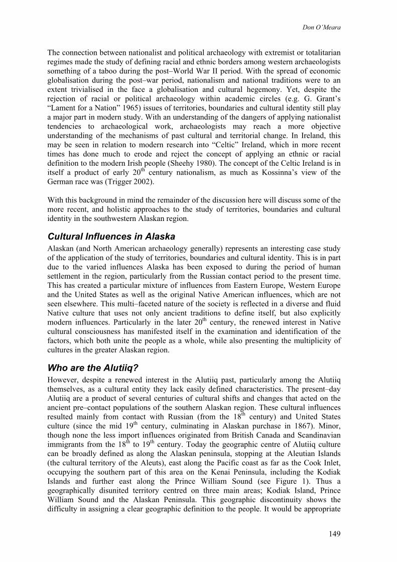
Don O’Meara
149
The connection between nationalist and political archaeology with extremist or totalitarian regimes made the study of defining racial and ethnic borders among western archaeologists something of a taboo during the post–World War II period. With the spread of economic globalisation during the post–war period, nationalism and national traditions were to an extent trivialised in the face a globalisation and cultural hegemony. Yet, despite the rejection of racial or political archaeology within academic circles (e.g. G. Grant’s “Lament for a Nation” 1965) issues of territories, boundaries and cultural identity still play a major part in modern study. With an understanding of the dangers of applying nationalist tendencies to archaeological work, archaeologists may reach a more objective understanding of the mechanisms of past cultural and territorial change. In Ireland, this may be seen in relation to modern research into “Celtic” Ireland, which in more recent times has done much to erode and reject the concept of applying an ethnic or racial definition to the modern Irish people (Sheehy 1980). The concept of the Celtic Ireland is in itself a product of early 20th century nationalism, as much as Kossinna’s view of the German race was (Trigger 2002). With this background in mind the remainder of the discussion here will discuss some of the more recent, and holistic approaches to the study of territories, boundaries and cultural identity in the southwestern Alaskan region.
Cultural Influences in Alaska Alaskan (and North American archaeology generally) represents an interesting case study of the application of the study of territories, boundaries and cultural identity. This is in part due to the varied influences Alaska has been exposed to during the period of human settlement in the region, particularly from the Russian contact period to the present time. This has created a particular mixture of influences from Eastern Europe, Western Europe and the United States as well as the original Native American influences, which are not seen elsewhere. This multi–faceted nature of the society is reflected in a diverse and fluid Native culture that uses not only ancient traditions to define itself, but also explicitly modern influences. Particularly in the later 20th century, the renewed interest in Native cultural consciousness has manifested itself in the examination and identification of the factors, which both unite the people as a whole, while also presenting the multiplicity of cultures in the greater Alaskan region.
Who are the Alutiiq? However, despite a renewed interest in the Alutiiq past, particularly among the Alutiiq themselves, as a cultural entity they lack easily defined characteristics. The present–day Alutiiq are a product of several centuries of cultural shifts and changes that acted on the ancient pre–contact populations of the southern Alaskan region. These cultural influences resulted mainly from contact with Russian (from the 18th century) and United States culture (since the mid 19th century, culminating in Alaskan purchase in 1867). Minor, though none the less import influences originated from British Canada and Scandinavian immigrants from the 18th to 19th century. Today the geographic centre of Alutiiq culture can be broadly defined as along the Alaskan peninsula, stopping at the Aleutian Islands (the cultural territory of the Aleuts), east along the Pacific coast as far as the Cook Inlet, occupying the southern part of this area on the Kenai Peninsula, including the Kodiak Islands and further east along the Prince William Sound (see Figure 1). Thus a geographically disunited territory centred on three main areas; Kodiak Island, Prince William Sound and the Alaskan Peninsula. This geographic discontinuity shows the difficulty in assigning a clear geographic definition to the people. It would be appropriate

Cultural Landscapes in South Western Alaska
150
to say that this geographic area is merely the physical space in which the culture is centred but not rigidly bound: though this area is associated with the Alutiiq it does not define them.
Who defines a people? An important element of archaeological and anthropological work is not merely to study a particular cultural group in its social context but also to interpret past work and past conclusions devised for that group. It is important to understand the limits and biases which are inherit in all social studies, least modern studies unthinkingly accept past conclusions as inflexible. In particular, the prejudices which early and modern studies carry with them can easily confine the people under study as anonymous and unspeaking elements of the archaeological and anthropological record. In the case of the Alutiiq, and many other groups, their study was traditionally dominated by four groups: early ethnographers, modern anthropologists, linguists and archaeologists. In the early period of contact these cases studies were generated by non–Native people who belonged to traditions which saw themselves at odds with Native culture. Another issue, which should be explored, is the problem that these four study areas (ethnography, anthropology, linguistics and archaeology) may be at odds with each other if their conclusions and assumptions do not correlate. In this case, it may be that the cultural complexity is deeper than anticipated, or that the original information has been misinterpreted in some fashion. As Anderson believes “To understand them [cultural groups] properly we need to consider carefully how they have come into historical being, in what ways their meanings have changed over time and why today they command such profound emotional legitimacy” (Anderson 1991, 4). The group that traditionally has been excluded from the investigations into the Alutiiq is the Alutiiq people themselves, though much progress has been made in recent times by Alutiiq Elders to raise cultural awareness and interest among their own people.
Figure 1—Map of Alaska showing the principle locations mentioned in the text and the Alutiiq lands around
Kodiak Island and the Kenai Peninsula.
Early Studies of Native Americans in Southern Alaska Ethnography Though sharing comparative aspects with anthropology, ethnography in its early form dealt more closely with the descriptions of peoples and cultures, rather than with humankind in general, as with anthropology. Though ethnography is a primary method of anthropology,

Don O’Meara
151
its focus (before the modern period) is more closely based on description rather than explanation (Agar 1996). Early ethnographers include many of the first non–Natives peoples to explore the Alaskan region and describe its people. These descriptions are rooted in the travel writing of the period, which sought to introduce newly discovered lands to interested Europeans or merely to relate a narrative, an important element of which is the description of the native people. Mungo Parks’ Travels in the Interior of Africa and Bernal Díaz’ Conquest of New Spain could be seen as belonging to the same loose genre. The early explorers to the region carried out early ethnographic work in the southern Alaska region in the early 18th century. These men (and most of the pre–modern work was carried out by men, another bias) were heavily influenced by the dominant philosophies which were being discussed in Europe at the time. During the 18th century the theories of the Enlightenment played an important part in the development of early ethnographic work, which sought to present the Euro–centric economic and social expansion as being ‘natural’ in the development of European society (Crowell and Luhrmann 2001, 21–70). Thus on a 1802–03 expedition to Alaska Gavriil Davydov, whose outlook was heavily influenced by the pervading Enlightenment philosophies of the time, studied Alaskan culture with the intention of comparing “man enlightened by science and one guided only by nature” (Davydov, quoted in Crowell et al. 2001, 8). In other early ethnographic accounts, it is likely that a political reason lay behind the interpretation of Native Alaskan culture. English explorers tended to see the people of southern Alaska as being culturally connected with the Eskimos of the western Atlantic. Since the early contact between Native Americans and English explorers such as Forbisher (Dumond 1987, 11), it had been the goal of many English, and European, explorers to find the North West Passage, which would lead between the Atlantic and the Pacific. In his assessment of the Alutiiq Captain Cook concluded in 1778 that there lay an Eskimo connection, which might theoretically be found through the long searched for North West Passage. This emphasized an east–west orientation of the Native populations. In contrast Georg Steller concluded a Siberian connection, which fitted in with the continuing expansion of the Russian Empire in the 18th century through Siberia and eventually into what would become Alaska. Thus, the dominant Russian interpretation viewed Native population in a west–east fashion. Further explorers presented other explanations. Spanish based explorers in the late 18th century from Artega to Fidalgo emphasized connection between Native Alaskans and other peoples of the Pacific coast who resided within territory claimed by Spain. Thus, a south–north connection was also suggested. In these cases, the emphasis was placed on connecting the southern Alaskans with the political or territorial aspirations of the country from which the observer originated (Crowell and Luhrmann 2001, 21–23). Thus, though modern Alaskan history is fortunate to have a wealth of ethnographic accounts for the early contact period this information is biased heavily by the philosophical and political backgrounds of the writers. Early Linguistic Conclusions and Ethnography Nevertheless these early ethnographic accounts do provide some valuable information concerning the internal divisions within the Native populations though early linguistic assumptions. Linguistics aims to study and understand the mechanism and process of verbal and non–verbal communications in human society. This also includes studies of variations of languages temporally and spatially, social importance of language, and the link between language and culture.
Cultural Landscapes in South Western Alaska
152
In particular the fur hunter and explorer Stephen Glotov explored Kodiak island in 1763 he noted that the Kodiak peoples spoke in a language which was not understood by his Aleut guides despite the relatively close proximity of the two groups (Dumond 1987, 18). Similarly, Knud Rasmussen, a member of the Fifth Thule Expedition’s voyage of exploration, was able to converse with Eskimos from Greenland, in the furthest eastern section of North America, all the way to Norton Sound, south of the Bering Straits (Dumond 1987, 23). Further, south however his Eskimo dialect was no longer easily interpreted. Through the entire rim of the North American Artic the Eskimo dialect dominated within the Gulf and Penninsula of Alaska seven different dialects can be identified; Central Yup’ik, Unangan Aleut, Alutiiq, Athabascan, Eyak, Tlingit and Haida. This is an important point when considering the part language plays in ethnic identity and territory. Some languages may stretch over many thousands of kilometers uninterrupted, while others may be concentrated within a much less diverse area. Similarly, the languages of the Bering Sea and the Aleutian islands have been classified as a single Eskimo–Aleut language sharing a common ancient source. Again, this is not evidence that these languages were intelligible to each other, or that they might share some sort of recognized cultural affinity among themselves (Dumond 1987, 21). If we consider the affirmation by Celtic scholars that the Celtic peoples of Europe shared a single Indo–European language then it can also be said that the peoples of modern Romania, France and Argentina all speak a Romance language. We would not in this circumstance imagine that they all share a perceived cultural unity, or that they are even linguistically intelligible to each other. Thus, scholars of Alaskan prehistory have a range of language and dialects with which to examine the link between linguistic and cultural heritage and to gather whether such links can be successfully applied to the assessment of prehistoric human populations. This is not without its problems when attempts are made to link linguistic differences to ethnography, anthropological and archaeological divisions.
Defining Themselves However, the term Alutiiq is used to describe the people living in the regions of the Alaskan Peninsula, Kodiak Island and Prince William Sound its origins lie with the Russian word Aleuty. This generic term was applied to people living on or near the Aleutian Islands. Today the term Aleut is used by Yup’ik Eskimos and Iliamna Athabascans to define themselves within a group of Native communities, which shared a similar recent history despite their distance and cultural dissimilarities with the Aleutian Aleuts. For the modern Alutiiq the term “Sugpiat” is often used to refer to their people and culture, while the term “Sugtestun” refers to their language. It has been noticed by modern linguists that linguistically and culturally united groups can use contrasting names for themselves (Leer 2001). Thus, Alutiiq communities living in close proximity to each other can use different terms (Alutiiq or Sugpiat) to refer to all the groups collectively. Some of this confusion is to an extent due to Russian and American influences when populations groups were disrupted and some native languages were discouraged as part of the formal education system. It is important also to realize that the confusion is on the part of non–Native people such as anthropological and linguistic researchers who might prefer a simpler model and clearer borders to explain the territories and boundaries of the region (Crowley 2001, 95). The Alutiiq themselves often possess a fluid view of the identity as can be seen in the various terms they use to describe themselves.

Don O’Meara
153
Anthropology and the Alutiiq The people of southern Alaska have been exposed to a long anthropological tradition, as well as a later archaeological tradition. This can be said to have begin with the Russian Orthodox priest Ioann Veniaminov who lived on the Aleutians during the period 1824–34 and continued with the later work of Waldemar Jochelson who traveled to the region during the Kamchatka–Aleutian Expedition 1909–11 (Reedy–Maschner et al. 2002). Though this early anthropological work was conducted at the early stages of the development of the field it has been stated that the biggest problems have arisen since the 1970s; ironically, as anthropology was supposedly becoming more scientific (Crowell et al. 2001, 78). Again, much of these problems were linked to the imposition of theories and concepts, which were alien to Native culture, upon the Alutiiq. In the later 1960s, the Alutiiq (as well as other groups) were the subject of many anthropological studies. It has been noted that; “It was often difficult for village residents to understand why the anthropologists had arrived and what they wanted…By the 1980s anthropologists were beginning to wear out their welcome. From the perspective of many Alutiiq residents they were becoming more intrusive” (Crowell et al. 2001, 78). Reports were often not discussed with residents or were presented in a manner, which the local people could not interpret without a background in anthropology. In other cases, researchers would declare themselves an expert on Alutiiq culture after spending a few days at a single village. These many problems and issues combined to erode any good will that could be generated between researchers and local people. However, with a greater degree of interaction between archaeologists and Native groups, and with the emergence of Native archaeologists and anthropologists it is likely that in the future we shall see a rapprochement between Native tradition and the academic community. In particular, the work of Dr. Sven Haakanson Jr. stands out as an example of how this interaction might develop. Haakanson is the first Alutiiq, raised in an Alutiiq village, to earn a doctoral degree, earning a PhD in anthropology from Harvard in 2000. In his discussion on the role of Native peoples in anthropology Dr. Haakanson points out that research, even when presented as collaborative, often consists of researchers asking the questions, Natives presenting answers and the report writing by the researchers at a later point. In the true sense, this is not collaboration. Dr Haakanson also questions why Native people are asked to write from an emic perspective but not an etic perspective. That is to say, they are asked to write about their experiences living as part of a Native community but they are rarely asked to present this in a scientific anthropological sense because of the perception that they are biased (Haakanson 2001). Indeed, ‘Native Anthropologists’ are often asked to clarify whether they are writing from an emic or etic perspective when discussing modern or ancient aspects of their own culture. On the other hand, this same bias is not assumed when Irish archaeologists discuss issues of Irish history and archaeology, or indeed English studies of the Anglo–Saxon period or French studies of Roman Gaul. In his work, Dr Haakanson promotes a more inclusive concept of collaboration than that which had been previously practiced. In this sense, a new way forward may be presented in which anthropological and archaeological researches can be presented. Archaeology and the Alutiiq One particular problem, which has emerged with archaeological cultural divisions, is the classification of cultural remains based on single archaeological sites. Thus, the archaeological literature discusses “Kachemak People” and “Ocean Bay People” (named

Cultural Landscapes in South Western Alaska
154
after the site from which the primary material was excavated). However, these titles bear no meaning for the people in these areas or for Alutiiq’s generally. Indeed, archaeologists should ask whether these terms had any meaning in the past either. The imposition of geographic place names upon cultural titles may be convenient during the early identification of possible cultural groups, but these titles should always be fluid and subject to modification. However, the need to name and classify regions or objects often means linking it to a geographic location name the archaeological reality may be quite different, as subsequent research will show. In the case of Alutiiq, archaeological research the lack of engagement between Native groups and archaeologists and anthropologists was one factor, which has lead to the estrangement between archaeological and cultural classification systems. An example of the future of collaborative research can be seen in the manner in which archaeology has been embraced by many Native groups as a means of connecting with their past. In part, this embrace of the past has a basis in the historical experiences of the Alutiiq people. The rapid Russian conquest and the disruption of Native society through diseases and war led to major alterations in Alutiiq society (Crowley et al. 2001, 130). The first anthropologists to study the Alutiiq were looking at a people that had already spent 150 years as part of the Russian economic and social system of the Alaskan region. The extent to which this contact altered the people is unclear and so there is potential for archaeology to play a strong part in the continuing study of the Alutiiq, as well as raising awareness about their past among the people themselves. Treatment of the past among the Alutiiq contains a certain element of duality, however. In one sense, ancient artefacts can be a very real way of connecting younger generations of Alutiiqs with their heritage. On the other hand, particularly among older generations, the excavation of artefacts and their study is approached in a cautious manner. The past is approached with a mixture of reverence and caution, and thus in the modern period archaeological artefacts are treated as more than inanimate remains. Objects are associated with the spirit world and with the poisons of shamans. Indeed the treatment of shamans represents something of a duality within a culture, which looks with reverence to the ancient ancestral past while still maintaining elements of more recent acculturations. Russian Orthodox Christianity remains a dominant religion among many Native Alaskans and thus has had a strong influence on their moral and spiritual view of the world through almost three centuries of contact. Ethnographic accounts present shamans as possessing the power to perform both good and bad forms of magic (Crowell et al. 2001, 208–11). Indeed at recent conference of Alutiiq Elders (in 1997) a strong belief in the Russian Orthodox faith was discussed as a guard against the powers of a shaman (Crowell et al. 2001 19). The early 20th century archaeologist Waldemar Jochelson noticed this strong faith when he began excavating in southwestern Alaska. Noting that, “They show no evidence of respect either for their former [pre–Russian Orthodox conversion] mode of burial or for the graves of their non–baptized ancestors” (Jochelson 2002b, 41). This flippancy with regard to their ancestors noted by Jochelson does not seem to have been the case in other areas where archaeological investigations were greeted with suspicion for much of the 20th century. The guarded nature of treatment of the past was due not only to traditional belief systems but also due to the negative experiences during early archaeological explorations on the Alutiiq territories. These early collections of materials were often acquired without the permission of the local people and often without their knowledge.

Don O’Meara
155
During the 1870s, William H. Dall stole a collection of revered whalebones from a site on Kodiak Island while he was collecting material for the Smithsonian Institute. Later Aleš Hrdlička would gain notoriety in his collection of thousands of skeletal remains from all over the Alaskan region, though with a particularly large collection from Kodiak Island (Crowell et al. 2001, 91). In his writing Hrdlička also make known that he collected “specimens” from relatively recently inhumed individuals. Native accounts of the arrival of the archaeologists all assume that the men were looking for jewelry or other valuables on the bodies as the following relates; “At that time they buried the chiefs and everything with their garments and what not and that’s what they were after when they found the skulls…some of ‘em had gold teeth and that’s what they were after” (Crowell 2001, 94). With the emergence of Native groups who in the 1980s agitated for political recognition of their rights to their ancestral remains Alaskan groups followed suit and requested the repatriation of remain (there were over 4,000 skeletal remains from Alaska held by the Smithsonian alone). This repatriation was seen as an important step in the assertion of Native claims to their own cultural heritage. Far from hindering archaeological work and research, as the repatriation of remains is often credited with, this event happened as a time of increased involvement on Native people in their archaeological past (Gosden 2005, 146–151). Through the 1990s and into the current century a series of archaeological excavations has heralded a new era of archaeological research into Alutiiq culture. Sites such as the Afognok Artel, Old Harbor and the Karluk Archaeological project have been conducted with the moral, and often financial, support of the Native corporations. Indeed, it is this type of collaborative research that will probably pay an important part in the future training of archaeologists who have grown up within Alutiiq communities and thus continue the new departure started by people such as Sven Haakansson Jr. Through a great cultural awakening since the 1980s the Alutiiq people have embraced a better understanding of their culture through engagement with the past but also and perhaps more importantly, through internal debate and dialogue. The passing of the ‘Alaskan Native Claims Settlement Act’ (ANCSA) in 1971 highlighted many of the problems with defining Alutiiq culture. Through this act, Alaska was divided into corporate areas, which aligned roughly to the cultural boundaries of Alaska’s Native groups. However, the Alutiiq groups found themselves divided into four different corporations among non–Alutiiq communities. This modern division of territory and cultural identity has been credited with encouraging a cultural reawakening among the Alutiiq who after the passing of the ANCSA found themselves assigned to corporations that divided them from other Alutiiq groups. Lantis believed that the build up to the ANSCA led to a cultural revitalization among other Native groups, which was only realized by the Alutiiq in the 1980s, after the passing of the Act (Lantis 1973, 116). This shows how cultural identity among Indigenous populations can be stimulated and encouraged by external forces, in this case a United States Government Act. The corporate cultural divisions created by ANSCA led to debate as to the meaning of these divisions among all groups, as well as by the Alutiiq themselves Through meetings and conferences of Native peoples, such as the 1997 ‘Alutiiq Elders Planning Conference’, and through publications and community based exhibitions, such as “Looking Both Ways: Heritage and Identity of the Alutiiq People” the people of the Alutiiq region have re–engaged with their culture. Debates such as ‘Who is an Alutiiq?’

Cultural Landscapes in South Western Alaska
156
pose important questions to Native people as regard their personal and communal treatment of their past, while also challenging the academic community to assess their methods of treating territory and cultural identity. Similarly, in Ireland the erosion of the myth of ‘Celtic’ identity, studies of the global Irish Diaspora and the changing demographics of Irish society has generated debates as to the nature of Irish identity. It is likely that demographic changes in the future will further encourage investigation into Territories, Boundaries and Cultural Identity in Ireland, both past and present. Among historic and sociological interpretations of cultural identity, archaeology too can play its part as part of a much broader academic field. Benedict Anderson has raised many issues surrounding the modern concepts of nations and national identity, which can be applicable to nation states like Ireland or cultural groups such as the Aleutiiq. In Anderson’s concept of the ‘imagined community’ he believes any large social groups are imagined because “the members of even the smallest nation will never know most of their fellow–members, meet them or even hear of them, yet in the mind of each lives the image of their communion… Communities are to be distinguished, not by their falsity of genuineness, but by the style in which they are imagined” (Anderson 1991, 6). However, debate on the origins and development of Territories, Boundaries and Cultural Identity will undoubtedly continue indefinitely as long as new evidence emerges perhaps the words of Stephen Shennan should be remembered:
“As far as reconstructing the past is concerned, traditional origin myths are as good as archaeology, which is, in fact, simply a way of producing origin myths which as congenial to the way of thinking of a particular king of society. It is all a matter of upbringing” (Shennan 1989).
Acknowledgements Many thanks to all the members of the Cultural Resource Division of the Lake Clark, Katmai and Aniakchak National Park Service, Alaska. In particular, I wish to that Jeanne Schaaf for her continued support, as well as, Dave Tennessen, Ross Smith, Professor Brian Hoffman and Greg Dixon.
Bibliography Agar, M. 1996. The Professional Stranger: An Informal Introduction to Ethnography. New York:
Academic Press. Anon. 2006. Research Needs in Irish Archaeology: Framework for a National Archaeological
Research Programme. Interim Report by the Heritage Council to the Minister for the Environment, Heritage and Local Government.
Chapman, J. 1994. Destruction of a Common Heritage: the Archaeology of War in Croatia, Bosnia and Hercegovina. Antiquity 68, 120–26.
Cooney, G. 1995. Theory and Practice in Irish Archaeology. In J. Ucko (ed.), Theory in Archaeology. London and New York: Routledge.
Crowell, A.L., Steffian, A.F., Pullar G.L. (eds), 2001. Looking Both Ways: Heritage and Identity of the Alutiiq People. Fairbanks: University of Alaska Press.
Dikov, N.N. 2002. Translated by R.L. Brand. The Chini Cemetery: A History of Sea Mammal Hunters in Bering Strait. United States, Department of the Interior.
Dumond, D. 1987. The Eskimos and Aleuts. London: Thames and Hudson. Gosden, C. 2005. Indigenous Archaeologies. In C. Renfrew and P. Bahn (eds.), Archaeology: The
Key Concepts. London: Routledge.
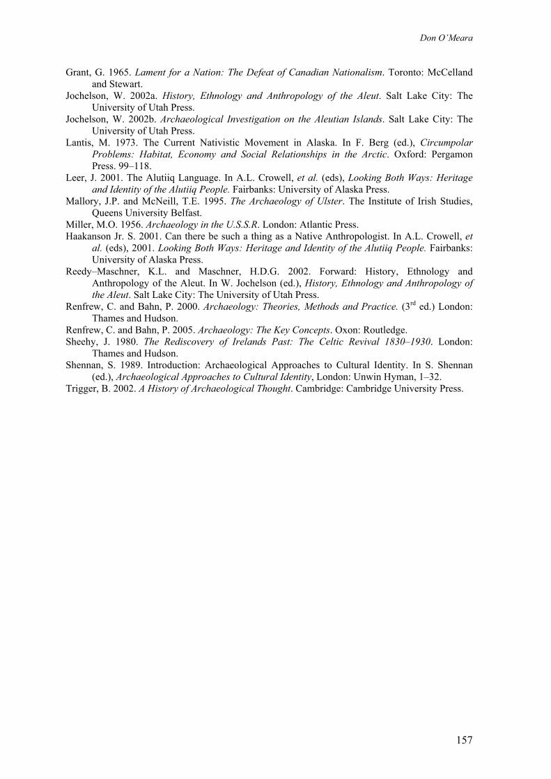
Don O’Meara
157
Grant, G. 1965. Lament for a Nation: The Defeat of Canadian Nationalism. Toronto: McCelland and Stewart.
Jochelson, W. 2002a. History, Ethnology and Anthropology of the Aleut. Salt Lake City: The University of Utah Press.
Jochelson, W. 2002b. Archaeological Investigation on the Aleutian Islands. Salt Lake City: The University of Utah Press.
Lantis, M. 1973. The Current Nativistic Movement in Alaska. In F. Berg (ed.), Circumpolar Problems: Habitat, Economy and Social Relationships in the Arctic. Oxford: Pergamon Press. 99–118.
Leer, J. 2001. The Alutiiq Language. In A.L. Crowell, et al. (eds), Looking Both Ways: Heritage and Identity of the Alutiiq People. Fairbanks: University of Alaska Press.
Mallory, J.P. and McNeill, T.E. 1995. The Archaeology of Ulster. The Institute of Irish Studies, Queens University Belfast.
Miller, M.O. 1956. Archaeology in the U.S.S.R. London: Atlantic Press. Haakanson Jr. S. 2001. Can there be such a thing as a Native Anthropologist. In A.L. Crowell, et
al. (eds), 2001. Looking Both Ways: Heritage and Identity of the Alutiiq People. Fairbanks: University of Alaska Press.
Reedy–Maschner, K.L. and Maschner, H.D.G. 2002. Forward: History, Ethnology and Anthropology of the Aleut. In W. Jochelson (ed.), History, Ethnology and Anthropology of the Aleut. Salt Lake City: The University of Utah Press.
Renfrew, C. and Bahn, P. 2000. Archaeology: Theories, Methods and Practice. (3rd ed.) London: Thames and Hudson.
Renfrew, C. and Bahn, P. 2005. Archaeology: The Key Concepts. Oxon: Routledge. Sheehy, J. 1980. The Rediscovery of Irelands Past: The Celtic Revival 1830–1930. London:
Thames and Hudson. Shennan, S. 1989. Introduction: Archaeological Approaches to Cultural Identity. In S. Shennan
(ed.), Archaeological Approaches to Cultural Identity, London: Unwin Hyman, 1–32. Trigger, B. 2002. A History of Archaeological Thought. Cambridge: Cambridge University Press.


159
Constitution of the AYIA 1. The name of this association shall be the Association of Young Irish
Archaeologists, hereafter referred to as the ‘Association’. 2. (i) The purpose of the Association shall be the forwarding of communication and
cooperation between interested parties, the provision of a forum for new ideas, and the fostering of interest and enthusiasm for Archaeology at ‘junior’ level in Ireland.
(ii) For the purpose of article 2 (i) above, ‘junior level’ shall be interpreted as undergraduate and postgraduate students, junior members of local Archaeological Societies and interested individuals– those new to the field of archaeology in Ireland. (iii) Membership of the Association shall comprise of two classes. a. those who, on payment of the required fee to the Archaeological Society of the
University, Institute or College, automatically become members of the Association.
And
b. those who must apply for membership by submitting their name and address
and required fee to the Membership Coordinator/Treasurer of the National Committee.
(iv) Each society that wishes to be involved in the activities of the Association will be required to pay an annual fee, which will be determined each year by the National Committee. Those not affiliated to a university archaeological society will also pay a required fee, also to be determined by the incoming National Committee and submitted to the Membership Coordinator/Treasurer.
3. The business of the Association shall consist principally of seminars, joint field
trips, publication and the Annual Conference. 4. (i) The business of the Association shall be conducted by the National Committee
who will at all times represent the interests of the members.
(ii) The National Committee shall consist of two representatives from each society (as defined below) to be nominated by that society (preferably a Postgraduate Association representative and the Auditor/Chairperson). Officers of the National Committee can be removed from their posts upon acknowledgement by other National Committee officers of conduct unbecoming a National Committee officer and/or the neglect of duties. A two–thirds majority of the National Committee is required for the removal of a committee member. (iii) a. It is the responsibility of each outgoing Society to ensure that a new
Association Representative is elected prior to the dissolution of said society (before the dissolution of the outgoing National Committee).

160
b. It is the responsibility of each Society, before dissolution, to forward names, addresses and contact numbers of their representatives to the Secretary of the National Committee. This information will be presented to the Chairperson of the outgoing National Committee whose responsibility it will be to facilitate the establishment of the new National Committee. (These stipulations will be written into the constitution of each Society involved).
(iv) For the purposes of this article, section (ii), the word ‘Society’ shall be interpreted as indicating the University Archaeology Societies of National University of Ireland, Dublin (NUID), Queens University, Belfast (QUB), National University of Ireland, Cork (NUIC), National University of Ireland, Galway (NUIG), and Trinity College Dublin (TCD), on condition that they have paid the required membership fee. (v) Provision may be made from time to time for representation of other areas, societies, or types of member not already provided for in this constitution. (vi) a. The hosting of the Association’s annual conference is to rotate annually
between the member societies on the basis of NUID – QUB – NUIC – NUIG – TCD.
b. If the designated society is unable to host the conference, it is deemed the
responsibility of the National Committee to inform the next society on said rotation (see 4(vi)a.) that they shall host the conference
(vii) Responsibility for the annual publication lies with the host centre, the editor of such publication to be elected by the host centre. (viii) Any financial profit/loss made from the annual conference and/or publication shall remain with the host centre
5. (i) The officers of the National Committee shall consist of Chairperson, Vice–Chairperson, Membership Coordinator/Treasurer, Conference Organiser and Secretary. The post of Secretary should be filled, each year, by the Association representative from the host centre in order to facilitate regular communication between officers of the National Committee and the Conference Organiser, who should also be from the host centre. The latter may be the auditor/chairperson of that centre’s society (already and officer of the National Committee) or a specially appointed officer (see 5 (ii) below) (ii) Provision may be made from time to time, at the discretion of the National Committee, for the creation of posts of special responsibility for the performance of specific functions (iii) Notification of the automatic members shall be forwarded to the Membership Co–ordinator within three weeks of the first meeting of the National Committee every year. Addittions of both class A and B members may be made throughout the year.

161
(iv) Officers (except the Secretary and the Conference Organiser) of the National Committee may hold office for two consecutive terms (in the same post or a different one) and shall be eligible for re–election after two further terms have expired. (v) At least three meetings, through four are suggested, of the National Committee shall be held per annum, the first meeting of the new committee in November (to be attended by at least one member of the previous committee), a second meeting at the end of January to finalise details of the annual conference, a meeting at the annual conference at the beginning of February, and a final meeting in April to distribute the Proceedings of the conference. Four, one representative of each society, shall constitute a quorum for such meetings. (vi) The Annual General Meeting of the Association members shall be held during the Annual Conference of the Association. Provision is also made for the convening of an extraordinary General Meeting. Notice of such is to be provided to members at least three weeks in advance of the proposed date. Application for convening an E.G.M can be made to the National Committee at least 5 weeks in advance of proposed date. The Committee shall then notify members. (vii) At least three weeks notice shall be given of meetings of the National Committee.
6. (i) This constitution shall take effect from 6th February, 2000.
(ii) Amendments to this constitution may be made at the Annual Conference under the following conditions.
a. That notice of intent to propose such amendments shall be given in writing to the Chairperson one month prior to the Annual Conference.
b. That a two–thirds majority of the members present, consenting to such amendments, is obtained.