Prob Using DGSP for DP Ops
9
DYNAMIC POSITIONING CONFERENCE October 13 – 14, 1998 SENSORS Problem Areas of DGPS R. H. Prothero & G. McKenzie Racal NCS Inc. (Houston) Session Index
Transcript of Prob Using DGSP for DP Ops

8/10/2019 Prob Using DGSP for DP Ops
http://slidepdf.com/reader/full/prob-using-dgsp-for-dp-ops 1/9
DYNAMIC POSITIONING CONFERENCE
October 13 – 14, 1998
SENSORS
Problem Areas of DGPS
R. H. Prothero & G. McKenzie
Racal NCS Inc. (Houston)
Session In

8/10/2019 Prob Using DGSP for DP Ops
http://slidepdf.com/reader/full/prob-using-dgsp-for-dp-ops 2/9
R.H.Prothero Sensors Problem Areas of DGPS
DP Conference Houston October 13-14, 1998 Page 1
T a b le o f C o n te n ts
1 . 0 A B S T R A C T . . . . . . . . . . . . . . . . . . . . . . . . . . . . . . . . . . . . . . . . . . . . . . . . . . . . . . . . . . . . . . . . 2
2 .0 A T Y P IC A L D G P S C O N F IG U R A T IO N . . . . . . . . . . . . . . . . . . . . . . . . . . . . . 3
3 . 0 T H E G P S S E G M E N T A N D P R O B L E M A R E AS . . . . . . . . . . . . . . . . . 3
4 .0 T H E U S E R O R M O B IL E P L A T F O R M . . . . . . . . . . . . . . . . . . . . . . . . . . . . . . 5
5 . 0 R E F E R E N C E S T A TIO N (S ) A N D M O N IT O R IN G F A C I L IT IE S 6
6 .0 T H E D IF F E R E N T IA L TR A N S M IS S IO N M E T H O D S . . . . . . . . . . . . . 7
7 . 0 C O N C L U S I O N S . . . . . . . . . . . . . . . . . . . . . . . . . . . . . . . . . . . . . . . . . . . . . . . . . . . . . . . . . 8
Session In

8/10/2019 Prob Using DGSP for DP Ops
http://slidepdf.com/reader/full/prob-using-dgsp-for-dp-ops 3/9
R.H.Prothero Sensors Problem Areas of DGPS
DP Conference Houston October 13-14, 1998 Page 2
1 .0
A B S T R A C T
This paper has been compiled for the specific purpose of presenting an overview of potential problems
that are associated with Differential Global Positioning Systems. The paper describes the types of
problems that can be experienced with the four main DGPS components which are; The GPS itself, The
User or Mobile Platform, Reference Station(s) and Monitoring Facilities and The Differential
Transmission Method. The paper concludes by looking at a method that has been proposed to assist DPoperators and DP systems in assessing the quality of DGPS data in real time operations and comments
that DGPS is an acceptable DP reference, providing that the correct system is used for the DP task in
hand, and that operators are trained in the use and first level fault finding for the DGPS system.
This paper has been compiled with reference to the UKOOA/IMCA Guidelines on the Use of DGPS as a
Position Reference in DP Systems.
Session In

8/10/2019 Prob Using DGSP for DP Ops
http://slidepdf.com/reader/full/prob-using-dgsp-for-dp-ops 4/9

8/10/2019 Prob Using DGSP for DP Ops
http://slidepdf.com/reader/full/prob-using-dgsp-for-dp-ops 5/9
R.H.Prothero Sensors Problem Areas of DGPS
DP Conference Houston October 13-14, 1998 Page 4
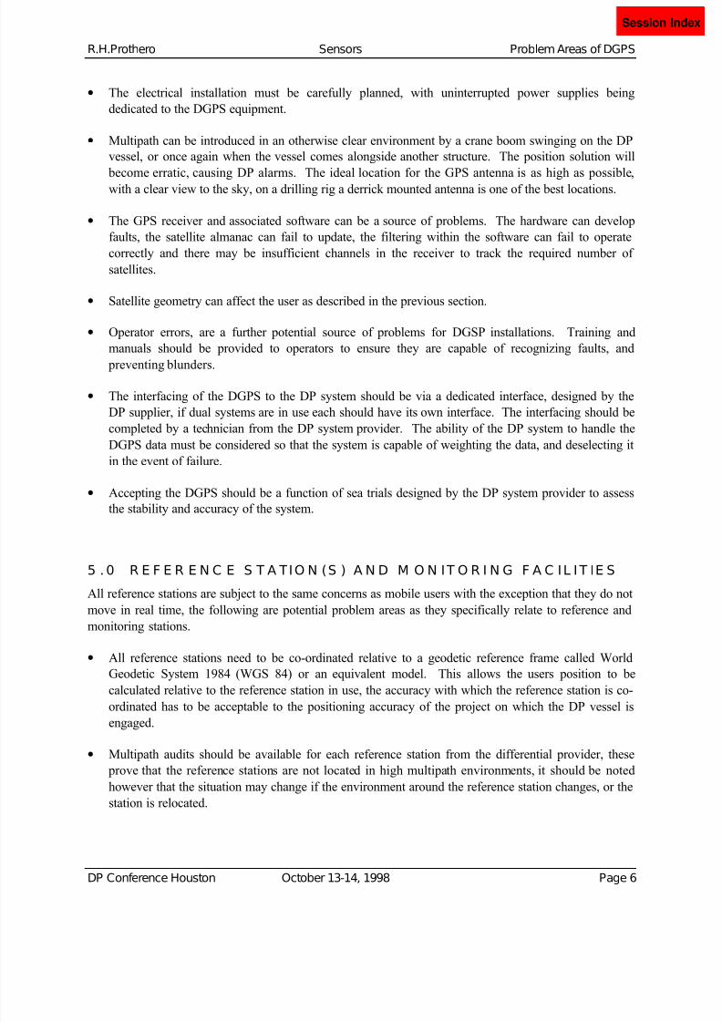
RIMS A
OFFSHORE MOBILE, DP VESSEL ONSHORE REFERENCE AND MONITOR STATION
Earth
Station
Communicatio
Satellite
GPS
Satellites
A T YP I C A L S A TE L L IT E B A S E D D G P S C O N F IG U R A TIO N
Sessio

8/10/2019 Prob Using DGSP for DP Ops
http://slidepdf.com/reader/full/prob-using-dgsp-for-dp-ops 6/9
R.H.Prothero Sensors Problem Areas of DGPS
DP Conference Houston October 13-14, 1998 Page 5
• Navigation bulletins are issued by the DOD alerting users to the status of satellites and are available
on the World Wide Web. As satellites are launched, die or are taken off line for maintenance the
coverage of the GPS constellation changes
• Satellite prediction software is available to determine the positions of the satellites in relation to the
users position, so which satellites are in view at what time can be determined.
• The geometric relation of the GPS satellites to the user at a particular point in time can affect the
quality of position. The Position Dilution Of Position (PDOP) is an indicator of good or bad GPS
coverage. Some satellites rise above the horizon for a short time and then set, their introduction into a
position solution can cause instability, an elevation mask is used to ensure these satellites are not
used.
• A minimum of four satellites are required to calculate the position and height of the user, if the
number of visible satellites falls to three, then a technique known as height aiding must be used to
determine the position of the user. Five satellites or more can be used to detect erroneous
observations and perform complete quality control checks.
• Two significant events will occur in August 1999. The first is an Almanac Rollover and the second is
a GPS week Rollover. At these time the number of bytes allocated to store the incremental number of
records will be exceeded and the counts will revert to zero. Users should confirm that the firmware in
their receivers and any software in use can cope with these events.
• Satellite signals are influenced by sunspot activity which is currently increasing, increased radiation
may affect both GPS satellites and Communication satellite signals. Meteor showers are expected in
November 1999 and 2000, the physical integrity of Communication satellites is an area of concern.
The Y2K problem is also an area of concern, with respect to the GPS.
4 .0 T H E U S E R O R M O B IL E P L A T F O R M
The problems that can be experienced by the user of a DGPS are a result of the problems associated with
the GPS configuration, and also the DGPS installation onboard the vessel being positioned, the problems
can be summarized as follows:
• GPS and Differential signal interference, possible causes have included cell phones, satellite
communications, and localized radio transmissions from civilian or military sources. The problems
manifest themselves as complete or intermittent loss of signals to the receive antennae.
•
Physical obstructions blocking GPS and differential signals, an example would be a DP vessel
working alongside a platform that relocates to another face of the platform, and in the process loses
all signals due to the platform obstructing the signals. Again the result can be intermittent or
permanent loss of signals
• Cable runs have to be carefully planned from a maintenance and signal loss aspect, the cutting of a
cable will lead to a sudden loss of data, while chaffing and water ingress will produce system
instability and intermittent faults. Lightning strikes on antennae also cause catastrophic problems.
Session In
8/10/2019 Prob Using DGSP for DP Ops
http://slidepdf.com/reader/full/prob-using-dgsp-for-dp-ops 7/9
R.H.Prothero Sensors Problem Areas of DGPS
DP Conference Houston October 13-14, 1998 Page 6
• The electrical installation must be carefully planned, with uninterrupted power supplies being
dedicated to the DGPS equipment.
• Multipath can be introduced in an otherwise clear environment by a crane boom swinging on the DP
vessel, or once again when the vessel comes alongside another structure. The position solution will
become erratic, causing DP alarms. The ideal location for the GPS antenna is as high as possible,with a clear view to the sky, on a drilling rig a derrick mounted antenna is one of the best locations.
• The GPS receiver and associated software can be a source of problems. The hardware can develop
faults, the satellite almanac can fail to update, the filtering within the software can fail to operate
correctly and there may be insufficient channels in the receiver to track the required number of
satellites.
• Satellite geometry can affect the user as described in the previous section.
• Operator errors, are a further potential source of problems for DGSP installations. Training and
manuals should be provided to operators to ensure they are capable of recognizing faults, and
preventing blunders.
• The interfacing of the DGPS to the DP system should be via a dedicated interface, designed by the
DP supplier, if dual systems are in use each should have its own interface. The interfacing should be
completed by a technician from the DP system provider. The ability of the DP system to handle the
DGPS data must be considered so that the system is capable of weighting the data, and deselecting it
in the event of failure.
• Accepting the DGPS should be a function of sea trials designed by the DP system provider to assess
the stability and accuracy of the system.
5 .0 R E F E R E N C E S T A TIO N (S ) A N D M O N IT O R I N G F A C IL IT IE S
All reference stations are subject to the same concerns as mobile users with the exception that they do not
move in real time, the following are potential problem areas as they specifically relate to reference and
monitoring stations.
• All reference stations need to be co-ordinated relative to a geodetic reference frame called World
Geodetic System 1984 (WGS 84) or an equivalent model. This allows the users position to be
calculated relative to the reference station in use, the accuracy with which the reference station is co-
ordinated has to be acceptable to the positioning accuracy of the project on which the DP vessel is
engaged.
• Multipath audits should be available for each reference station from the differential provider, these
prove that the reference stations are not located in high multipath environments, it should be noted
however that the situation may change if the environment around the reference station changes, or the
station is relocated.
Session In

8/10/2019 Prob Using DGSP for DP Ops
http://slidepdf.com/reader/full/prob-using-dgsp-for-dp-ops 8/9
R.H.Prothero Sensors Problem Areas of DGPS
DP Conference Houston October 13-14, 1998 Page 7
• Two sets of equipment should be available at the reference station, providing redundancy in case one
system should fail. Both systems should be running continuously along with any monitoring facilities
that may be incorporated.
• The means of communicating the differential corrections to the user will be focussed at either the
reference station or the DGPS suppliers hub where monitoring of the differential data may also occur.The integrity of the equipment used at these locations is paramount to the continuous operation of the
differential system, a data failure at this location will cause a similar loss offshore.
• If a network monitor is not available then local monitors can be established, these typically compute
the position of a known point at the monitor site and transmit the difference in position to the user
allowing him to see how accurate the differential corrections are in his work area.
6 .0 T H E D IF F E R E N T IA L T R A N S M IS S IO N M E T H O D S
Differential corrections are transmitted to users via radio frequencies. The main types of transmission arelisted below with their associated shortcomings
• UHF Radio Links. These are limited to a maximum range of 60 km, but have a very high update rate,
typically of 2 seconds, the systems can be thought of as being locally structured. These stations
usually have to be established on a project by project basis, are dependant on line of sight which can
cause difficulties due to antenna orientation, are usually installed on platforms and therefore subject
to power supply problems, hazard ratings and logistical problems regarding mobilization and
demobilization.
• MF Radio Links. These links have a maximum range of 700 km and some receivers are sold with the
differential receive capability built in, the systems can be thought of as being regionally structured.They have a slower update rate, and the frequencies are subject to atmospheric conditions especially
dawn and dusk effects, there are systems available that operate on dual frequencies to reduce these
shortcomings. Typical update rates are in the order of 10 to 15 seconds.
• Satellite Correction Links. These links have a maximum range of 2000 km and are considered to be
global in coverage, there are however gaps in the coverage as the systems are dependant of
communication satellite footprints. The systems are dependent on line of sight to the communications
satellite, so local masking needs to be considered. The update rate is dependent on the number of
stations that are being transmitted over the network, typical update rates are however in the order of 5
seconds or faster. These systems are also dependent on national telecommunication networks and the
communication satellites themselves.
Session In

8/10/2019 Prob Using DGSP for DP Ops
http://slidepdf.com/reader/full/prob-using-dgsp-for-dp-ops 9/9
R.H.Prothero Sensors Problem Areas of DGPS
DP Conference Houston October 13-14, 1998 Page 8
7 .0
C O N C L U S I O N S
One of the biggest problems with DGPS and DP systems has been answering the question “What went
wrong?”. The question is asked after an incident when the DPO has spent time stabilizing the system in
order to maintain the integrity of the operation the DP vessel is engaged on. In order to answer the
question the DPO would have had to have been scrutinizing the DGPS as the event occurred. Invariably
the DP system is responding to the event when the DPO first becomes aware of the problem, and de-selection and containment is the only option.
The UKOOA/IMCA committee looked at the issues and developed a data quality index that would allow
DGPS systems to output a single value to the DP systems reflecting the quality of data being provided
The method shows that as the quality of position degrades the value output decreases from nine to zero.
The DP system can then weight the DGPS solution accordingly and allow a voting system to decide
which DP sensor to believe, reducing the level of interaction required by the DPO. During position
instability the DPO is warned, and can make an informed decision regarding the DGPS data. Following
the incident the DPO can assess what occurred and provide a written evaluation.
DGPS is established as a DP reference system, when operated correctly it easily meets the requirements
of most DP operations. Problems with systems can occur within any one of the four main components
which are; The GPS itself, The User or Mobile Platform, Reference Station(s) and Monitoring Facilities
and The Differential Transmission Method. It must also be recognized that some of these components are
inherent to the overall system and a failure at one location can cause problems throughout the network.
The issues affecting users of DGPS as a DP reference is being able to recognize the limitations of the
different types of DGPS available, followed by purchasing, installing and maintaining the system
correctly. Once a DGPS has been chosen for a particular vessel and or operation the next issue is training
DP operators to be able to assess the quality of the data being provided, and to first level fault find in
order to isolate the location of problems within the DGPS network, prior to contacting the system provider for support is also a crucial area.
Session In