PRIORITIES FOR STORMWATER MANAGEMENT PLANNING IN SOUTH ... Stormwater... · PRIORITIES FOR...
8
PRIORITIES FOR STORMWATER MANAGEMENT PLANNING IN SOUTH AUSTRALIA 2016 - 2020 Stormwater Management Authority
Transcript of PRIORITIES FOR STORMWATER MANAGEMENT PLANNING IN SOUTH ... Stormwater... · PRIORITIES FOR...
PRIORITIES FOR STORMWATER MANAGEMENT PLANNING IN SOUTH AUSTRALIA 2016 - 2020
Stormwater Management Authority
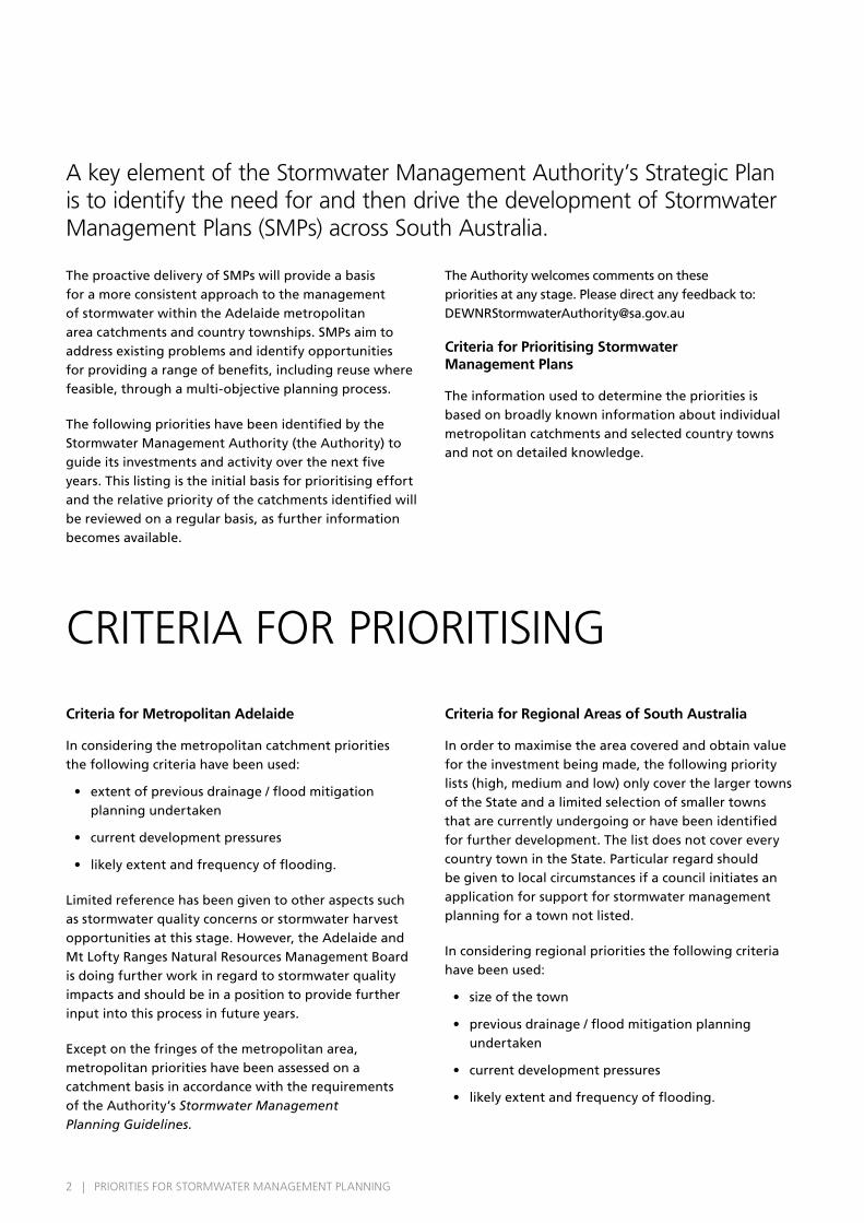
CRITERIA FOR PRIORITISING
Criteria for Metropolitan Adelaide
In considering the metropolitan catchment priorities the following criteria have been used:
• extent of previous drainage / flood mitigation planning undertaken
• current development pressures
• likely extent and frequency of flooding.
Limited reference has been given to other aspects such as stormwater quality concerns or stormwater harvest opportunities at this stage. However, the Adelaide and Mt Lofty Ranges Natural Resources Management Board is doing further work in regard to stormwater quality impacts and should be in a position to provide further input into this process in future years.
Except on the fringes of the metropolitan area, metropolitan priorities have been assessed on a catchment basis in accordance with the requirements of the Authority’s Stormwater Management Planning Guidelines.
Criteria for Regional Areas of South Australia
In order to maximise the area covered and obtain value for the investment being made, the following priority lists (high, medium and low) only cover the larger towns of the State and a limited selection of smaller towns that are currently undergoing or have been identified for further development. The list does not cover every country town in the State. Particular regard should be given to local circumstances if a council initiates an application for support for stormwater management planning for a town not listed.
In considering regional priorities the following criteria have been used:
• size of the town
• previous drainage / flood mitigation planning undertaken
• current development pressures
• likely extent and frequency of flooding.
The proactive delivery of SMPs will provide a basis for a more consistent approach to the management of stormwater within the Adelaide metropolitan area catchments and country townships. SMPs aim to address existing problems and identify opportunities for providing a range of benefits, including reuse where feasible, through a multi-objective planning process.
The following priorities have been identified by the Stormwater Management Authority (the Authority) to guide its investments and activity over the next five years. This listing is the initial basis for prioritising effort and the relative priority of the catchments identified will be reviewed on a regular basis, as further information becomes available.
The Authority welcomes comments on these priorities at any stage. Please direct any feedback to: [email protected]
Criteria for Prioritising Stormwater Management Plans
The information used to determine the priorities is based on broadly known information about individual metropolitan catchments and selected country towns and not on detailed knowledge.
A key element of the Stormwater Management Authority’s Strategic Plan is to identify the need for and then drive the development of Stormwater Management Plans (SMPs) across South Australia.
2 | PRIORITIES FOR STORMWATER MANAGEMENT PLANNING
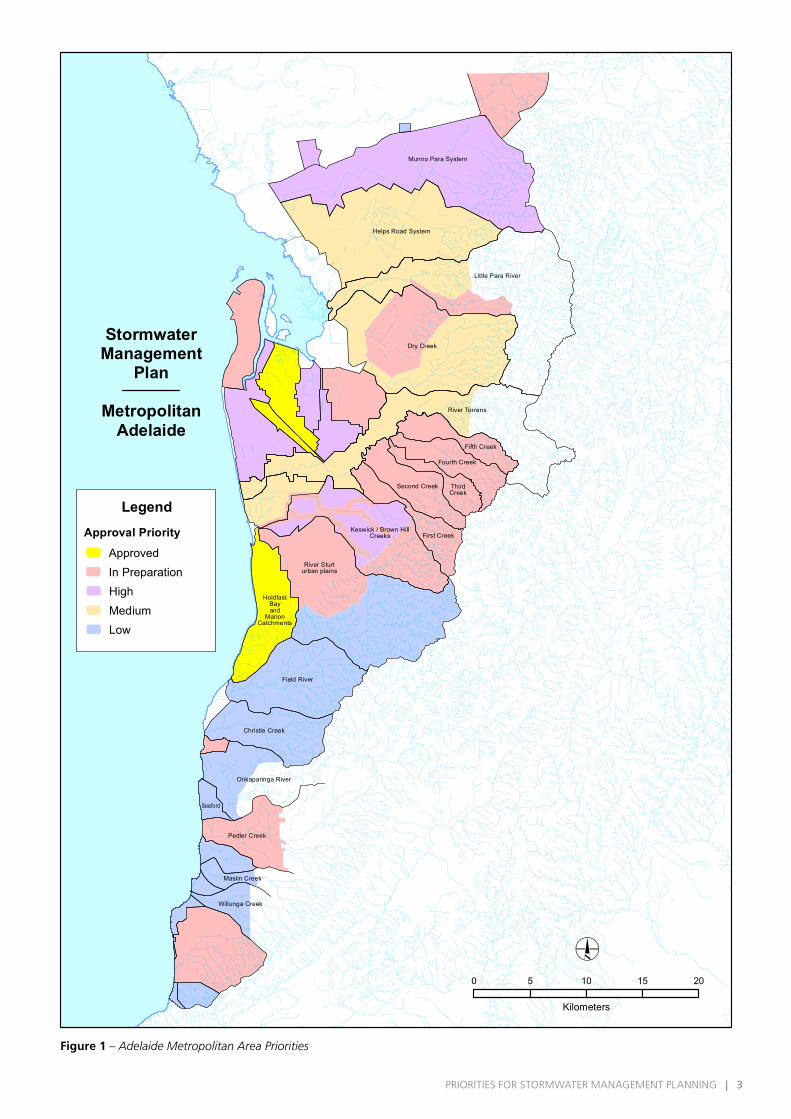
Figure 1 – Adelaide Metropolitan Area Priorities
Little Para River
Dry Creek
Fifth Creek
Fourth Creek
ThirdCreek
Second Creek
First Creek
River Torrens
Field River
Christie Creek
Onkaparinga River
Seaford
Pedler Creek
Maslin Creek
Willunga Creek
Helps Road System
Keswick / Brown HillCreeks
River Sturturban plains
HoldfastBayand
MarionCatchments
StormwaterManagement
Plan
MetropolitanAdelaide
0 5 10 15 20
Kilometers
Munno Para System
LegendApproval Priority
ApprovedIn Preparation High Medium Low
2 | PRIORITIES FOR STORMWATER MANAGEMENT PLANNING PRIORITIES FOR STORMWATER MANAGEMENT PLANNING | 3
The area defined as the Adelaide metropolitan area has been based on the Planning Strategy for Metropolitan Adelaide December 2007, which broadly means the plains and hills face area from the Gawler River (including Gawler) in the north to Sellicks Beach in the south.
SMPs that are completed, in preparation, proposed or identified as a high, medium or low priority by the Stormwater Management Authority are presented in Figure 1. Further detail on each of these categories and the SMPs that align with them follows below.
COMPLETED – APPROVED PLANS • Hallett Cove Creeks (Marion).
• Holdfast Bay and Marion catchments west of River Sturt (Holdfast Bay / Marion).
• Port Road Catchment (Charles Sturt / Port Adelaide Enfield).
• Torrens Road Catchment.
PLANS IN PREPARATION • Beach Road, Christies Beach local catchments
(Onkaparinga).
• Brown Hill / Keswick Creek system - main creeks only (Adelaide / Burnside / Mitcham / Unley / West Torrens).
• Cobbler Creek (Salisbury / Tea Tree Gully).
• Gawler (Gawler / Light).
• Lefevre Peninsula (Port Adelaide Enfield).
• North Arm East Drainage System (Port Adelaide Enfield / Prospect / Salisbury).
• Numbered Creeks into River Torrens (Norwood, Payneham & St Peters / Burnside / Campbelltown / Adelaide) Pedler Creek (Onkaparinga).
• Salisbury Escarpment (Salisbury / Tea Tree Gully)
• Silver Sands (Onkaparinga).
• River Sturt urban plains catchments (Marion / Mitcham / Unley / West Torrens).
HIGH PRIORITY (IN PRIORITY ORDER) 1. West Lakes Catchments, excluding Port Road
(Charles Sturt): Inner urban catchment with some of the poorest drained areas of Adelaide. Extensive redevelopment is likely in the catchment over the next thirty years. The Department of Planning, Transport and Infrastructure is also concerned with the long-term deterioration in the flood protection standard provided by the West Lakes lake due to sea level rise and on-going redevelopment in the catchment. The West Lakes lake flows into the Port River and an SMP for this area would also compliment the Lefevre Peninsula SMP, which has to commenced as regards water quality in the Port River.
2. Brown Hill and Keswick Creek system urban catchments (Adelaide / Burnside / Mitcham / Unley / West Torrens): Inner urban catchment with redevelopment pressures. Further detailed examination of the urban hydrology will provide better hydrologic information on which to design some of the key components proposed in the SMP for the main creeks in this catchment.
3. Port River Catchments on east side of the Port River (Port Adelaide Enfield): This area is low-lying and very vulnerable to stormwater and potentially tidal flooding due to sea level rise. An SMP for this area would also compliment the Lefevre Peninsula SMP with regard to water quality in the Port River.
4. Munno Para System (Playford): This is a rapidly developing urban area with no natural drainage system. Floodplain mapping in progress is likely to be followed by an SMP at Playford Council’s initiative.
5. Virginia (Playford): This is a developing township on the Gawler River floodplain, which is still floodprone for floods more frequent than a 100 year ARI event, despite flood mitigation works on the North and South Para Rivers undertaken by the Gawler River Floodplain Management Authority (GRFMA) in the last seven years. Although the GRFMA is currently investigating further flood mitigation works on the Gawler River system, which may include levee works
PRIORITIES FOR THE ADELAIDE METROPOLITAN AREA
4 | PRIORITIES FOR STORMWATER MANAGEMENT PLANNING
in the vicinity of Virginia, as a growth area in the 30 Year Plan for Metropolitan Adelaide, it is now appropriate that a separate SMP be developed for the Virginia township to cover flood threats from the Gawler River, flooding from other catchments and flooding from internal drainage in the town. Stormwater reuse potential should also be of importance as Virginia is located in an area with a strong demand for non-potable water.
6. Hindmarsh Enfield Prospect (HEP) and Days Road Drainage Systems (Port Adelaide Enfield / Prospect / Charles Sturt): Flat inner urban catchments with drainage system upgrades largely completed many years ago but with extensive redevelopment of the catchments now likely.
MEDIUM PRIORITY (to complete coverage of the older and flatter parts of Metropolitan Adelaide)
• Dry Creek tributaries and urban catchments on the east side of the Para escarpment (Tea Tree Gully / Port Adelaide Enfield).
• Helps Road Drain System (Salisbury / Playford) – floodplain mapping in progress.
• Little Para River urban catchment (Salisbury / Playford) – floodplain mapping in progress.
• Mile End Cowandilla Drainage System (West Torrens / Charles Sturt).
• Numerous urban catchments direct into the River Torrens (West Torrens / Charles Sturt / Adelaide / Walkerville / Prospect / Norwood, Payneham and St Peters / Port Adelaide Enfield / Campbelltown / Tea Tree Gully).
LOW PRIORITY (newer outer suburbs and/or developing areas covered by newer drainage/flood mitigation studies)
• Angle Vale urban catchments into Gawler River or Munno Para system (Playford).
• Belair / Blackwood / Glenalta / Coromandel Valley / Flagstaff Hill area to River Sturt (Mitcham / Onkaparinga).
• Christie Creek catchment (Onkaparinga).
• Field River catchment (Onkaparinga / Marion).
• Maslin Creek and Willunga Creeks urban catchments either direct to sea or into Maslin or Willunga Creeks (Onkaparinga).
• Noarlunga and Seaford area catchments direct to the sea or Onkaparinga River (Onkaparinga).
• Port Willunga and Aldinga Beach urban catchments (Onkaparinga).
• Sellicks urban catchments either direct to sea or into Sellicks Creek (Onkaparinga).
4 | PRIORITIES FOR STORMWATER MANAGEMENT PLANNING PRIORITIES FOR STORMWATER MANAGEMENT PLANNING | 5
In accordance with the Authority’s Stormwater Management Planning Guidelines, this section identifies discrete built-up areas for country towns that require the development of SMPs, not including surrounding rural broad acre land.
COMPLETED – APPROVED PLANS • Laura.
• Moonta and Port Hughes.
• Port Lincoln.
• Streaky Bay.
• Truro.
• Wasleys.
• Tumby Bay.
PLANS IN PREPARATION • Auburn.
• Freeling / Greenock / Kapunda.
• Kadina.
• Manoora / Mintaro / Rhynie / Riverton / Saddleworth / Stockport / Tarlee.
• Mount Barker.
• Port Elliot.
• Port Pirie.
• Two Wells.
• Yankalilla, Normanville and Carrickalinga.
• Burra.
• Whyalla.
CURRENTLY PROPOSED• Wallaroo - to follow on from the Kadina SMP
currently in preparation.
HIGH PRIORITY• Clare: unofficial capital of the mid north. The town is
vulnerable to flooding from the Hutt River, although some channel widening work has been carried out. Previous drainage / flood mitigation planning does not fully cover the town. The Council is currently actively undertaking SMPs for other towns in its area.
• Renmark: largest town in the Riverland. Vulnerable to River Murray flooding with a River Murray flood protection levee system of a variable standard. Previous drainage / flood mitigation planning does not fully cover the town. Stormwater quality is also of interest as the town drains to the River Murray.
• Port Augusta: significant town at the head of Spencer Gulf. While growth is currently subdued, the town is likely to grow in response to further mining development. Parts of the town are low-lying and previous drainage / flood mitigation planning does not fully cover the town.
MEDIUM PRIORITY• Berri: previous drainage / flood mitigation planning
does not fully cover the town and the town drains to River Murray.
• Cleve: limited development, parts of town vulnerable to flooding and the town has no previous drainage / flood mitigation planning.
• Coffin Bay: development pressures and existing drainage / flood mitigation planning from the 1980s is likely to be outdated. The quality of stormwater discharge to the sea is also likely to be of interest as Coffin Bay itself is semi land locked and there is a growing aquaculture industry.
• Crafers / Aldgate / Bridgewater - although the area in general is not vulnerable to flooding, stormwater quality is of concern as runoff is to natural watercourses and ultimately Mount Bold reservoir. There has been no previous drainage / flood mitigation planning.
PRIORITIES FOR REGIONAL SOUTH AUSTRALIA
6 | PRIORITIES FOR STORMWATER MANAGEMENT PLANNING

• Goolwa: undergoing further development, parts of the town are low-lying and current drainage / flood mitigation planning does not fully cover the town.
• Hamley Bridge: development pressures and no previous drainage / flood mitigation planning.
• Mount Gambier: continuing development with drainage to local groundwater and no other drainage planning.
• Nairne: undergoing development and no previous drainage / flood mitigation planning.
• Nuriootpa: although already protected from North Para River flooding, vulnerable to flooding from another creek and no previous drainage / flood mitigation planning.
• Port Vincent: relatively small town on the eastern side of Yorke Peninsula but undergoing development due to tourism and leisure ventures. The town has no previous drainage / flood mitigation planning.
• Roseworthy: identified growth area in the 30 Year Plan for Metropolitan Adelaide. Relatively recent drainage and flood mitigation planning needs to be updated and expanded into a full SMP.
LOW PRIORITY• Bordertown: parts of the town are vulnerable to
flooding from Tatiara Creek on a very infrequent basis. Although the rest of the town has no previous drainage / flood mitigation planning, the town is relatively flat with limited growth prospects and no apparent other pressing problems.
• Ceduna: limited growth prospects and no external flooding threats.
• Jamestown: limited growth prospects with drainage / flood mitigation planning available from the 1990s.
• Loxton: more recent drainage / flood mitigation planning available and town is clear of the River Murray.
• Millicent: limited previous drainage / flood mitigation planning; however, town is located on a ridge and drains to surrounding swamps on both sides.
• Murray Bridge: continuing development but extensive drainage and flood mitigation planning in the last decade.
• Naracoorte: some development but drainage and flood mitigation planning in the last decade.
• Penola: limited growth prospects and, although town is very flat and swampy, the Council has available an early draft version of a stormwater management plan.
• Peterborough: limited growth prospects and despite no previous drainage / flood mitigation planning, no pressing problems.
• Roxby Downs: modern town planned to modern standards.
• Strathalbyn: largely situated above Angas River flood levels and comprehensive drainage study of town undertaken in the 1990s.
• Tanunda: above North Para flood levels and no other pressing problems.
• Victor Harbor: continuing development but Council has available an early draft stormwater management plan produced in the last decade.
• Waikerie: drainage / flood mitigation plan available from the 1980s and town is largely clear of the River Murray.
6 | PRIORITIES FOR STORMWATER MANAGEMENT PLANNING PRIORITIES FOR STORMWATER MANAGEMENT PLANNING | 7

FIS9
3849
Stormwater Management Authority
DISCLAIMER: While reasonable efforts have been made to ensure
the contents of this publication are factually correct, the Stormwater
Management Authority makes no representations and accepts no
responsibility for the accuracy, completeness or fitness for any particular
purpose of the contents, and shall not be liable for any loss or damage
that may be occasioned directly or indirectly through the use of or reliance
on the contents of this publication. Reference to any company, product
or service in this publication should not be taken as a endorsement of the
company, product or service.
Licensed under Creative Commons Attribution 3.0 Australia License www.creativecommons.org/licenses/by/3.0/au Copyright Owner: Crown in right of the State of South Australia 2015