PRINCE WILLIAM SOUND - dec.alaska.gov · is is nt intene r navigatinal se eorap epone tratee for...
34
June 26, 2012 Western Alaska – SOUTHERN ZONE SITES with developed GEOGRAPHIC RESPONSE STRATEGIES BERING SEA S-01 Kangirlvar Bay S-02 Kolavinarak River S-03 Kinia River S-04 Kinak Bay S-05 Kikegtek & Pingrbek Islands S-06 Kwigillingok River S-07 Kongiganak River S-08 Ishkowik River S-09 Eek Channel S-10 Kanektok River S-11 Carter Bay S-12 Goodnews Bay S-13 Salmon River S-14 Chaguan Bay S-15 Security Cove S-16 Nanuak Bay Nunivak Island Goodnews Bay Platinum Quinhagak BETHEL DILLINGHAM K U S K O K W I M B A Y E t o l i n S t r a i t Goodnews Bay Togiak Bay S12 S13 S14 S15 S16 S10 S11 S01 S03 S02 S04 S05 S09 S06 S07 S08
Transcript of PRINCE WILLIAM SOUND - dec.alaska.gov · is is nt intene r navigatinal se eorap epone tratee for...

June 26, 2012
Western Alaska – SOUTHERN ZONESITES with developed GEOGRAPHIC RESPONSE STRATEGIES
B E R I N G S E A
S-01 Kangirlvar BayS-02 Kolavinarak RiverS-03 Kinia RiverS-04 Kinak BayS-05 Kikegtek & Pingrbek IslandsS-06 Kwigillingok RiverS-07 Kongiganak RiverS-08 Ishkowik River
S-09 Eek ChannelS-10 Kanektok RiverS-11 Carter Bay S-12 Goodnews BayS-13 Salmon RiverS-14 Chaguan BayS-15 Security CoveS-16 Nanuak Bay
Nunivak Island
Goodnews Bay
Platinum
Quinhagak
BETHEL
DILLINGHAM
K U S K O K W I M B AY
Etolin Strait
Goodne ws Bay
Tog iak Bay
S12
S13
S14
S15
S16
S10
S11
S01
S03
S02
S04
S05
S09
S06
S07
S08

This is not intended for navigational use.
Geo
gra
ph
ic R
esp
on
se S
trate
gie
s fo
rW
est
ern
Ala
ska S
ubare
a, S
ou
thern
Zon
e
NUKA Research & Planning Group, LLC.June 26, 2012
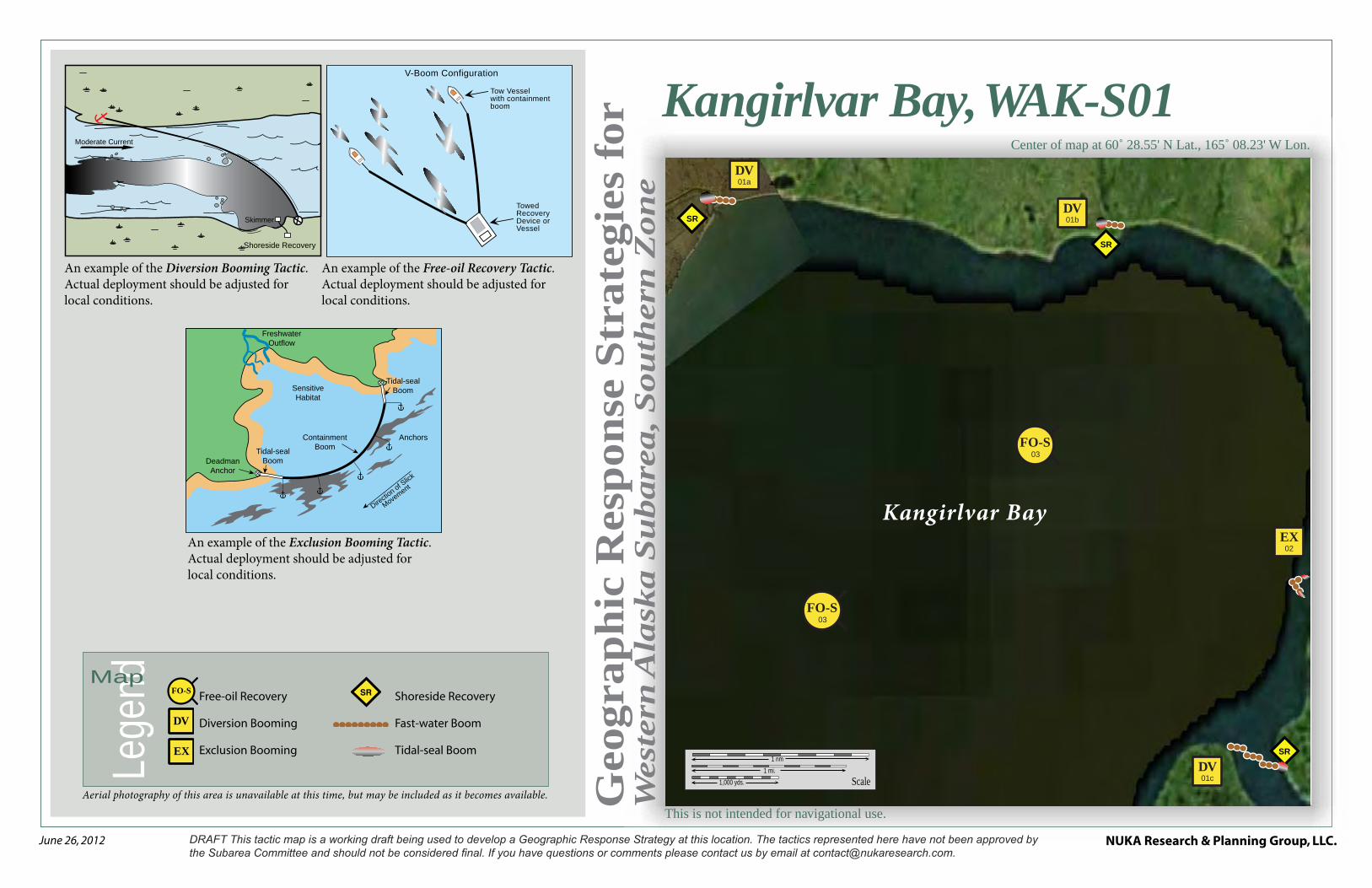
Kangirlvar Bay, WAK-S01Center of map at 60˚ 28.55' N Lat., 165˚ 08.23' W Lon.
Lege
ndMap
Aerial photography of this area is unavailable at this time, but may be included as it becomes available.
An example of the Free-oil Recovery Tactic. Actual deployment should be adjusted for local conditions.
An example of the Exclusion Booming Tactic. Actual deployment should be adjusted for local conditions.
An example of the Diversion Booming Tactic. Actual deployment should be adjusted for local conditions.
V-Boom Configuration
Tow Vessel with containment boom
Towed Recovery Device or Vessel
Moderate Current
Shoreside Recovery
Skimmer
Freshwater Outflow
Deadman Anchor
Tidal-seal Boom
Tidal-seal Boom
Containment Boom
Anchors
Directio
n of Slick
Movement
Sensitive Habitat
Free-oil Recovery
Diversion Booming
Exclusion Booming
DV
SRFO-SShoreside Recovery
Fast-water Boom
Tidal-seal BoomEX
Scale
1 nm1 mi.
1,000 yds.
SR
SR
SR
FO-S03
FO-S03
01cDV
01bDV
01aDV
02EX
Kangirlvar Bay

NUKA Research & Planning Group, LLC.NOTE: Sensitive resource information can be found on other maps which can be accessed through the sensitive area section of the Western Alaska Subarea Contingency Plan: http://dec.alaska.gov/spar/perp/plans/scp_wak.htm.
Site
Inf
orm
atio
n fo
r W
este
rn A
lask
a, W
AK
-S01
Western Alaska Subarea Geographic Response Strategies DRAFT June 2012
WAK-S01
ID Location and Description Response Strategy Implementation Response Resources Staging Area Site Access Resources Protected (months)
Special Considerations
S-01-01
DV
Kangirlvar Bay
Toksook Bay a. Lat. 60º31.91'N
Lon. 165º06.25'W
Alackuchak Creek
b. Lat. 60º 32.62'N Lon. 165º03.82'W
Toksook River
c. Lat. 60º 30.21'N Lon. 164º58.26'W
Divert and Collect
Divert oil to shore side collection location on the shore of the identified creeks and rivers in Kangirlvar Bay
Deploy anchors and boom with skiffs (class 6).
Place fast-water boom at the proper angle to divert incoming oil to the collection sites. For (c) cascade 3 sections of boom to deflect the oil to the collection site. Complete the arrays with 60-foot sections of tidal seal boom.
Set up shore-side recovery and tend throughout the tide.
Boom Lengths:
a. 300 ft
b. 300 ft.
c. 900 ft.
Deployment Equipment
1500 ft. fast-water boom 180 ft. tidal seal boom 10 ea. anchor systems 12 ea. anchor stakes 3 ea. shore-side recovery systems
Vessels 3 ea. class 6
Personnel/Shift 6 ea. vessel crew/general techs 4 ea. response techs Tending
Vessels 2 ea. class 6
Personnel/Shift 4 ea. vessel crew/general techs 3 ea. skilled tech
Toksook Bay Via marine waters
Chart 16006
Fish- intertidal spawning- salmon, herring (June-Sept.), arctic char, sheefish,white fish,
Birds-waterfowl, seabird and shorebird concentration
Marine mammals- seals
Habitat- exposed tidal flats, peat shoreline, marsh
Human use-subsistence
Vessel master should have local knowledge.
Use appropriate measures as outlined in the STAR manual to protect the shoreline.
Title 41 permitting required from ADNR.
THREATENED OR ENDANGERED SPECIES/ HABITAT POSSIBLE. Discuss with DOI prior to on-site operations.
Surveyed: not yet
Tested: not yet
S-01-02
EX
Kangirlvar Bay Lat. 60º 31.40'N Lon. 164º57.67'W
Exclusion
Exclude oil from impacting the identified stream and in Kangirlvar Bay.
Deploy anchors and boom with skiffs (class 6) at high tide.
Place fast-water boom in a chevron pattern across the mouths of the identified stream. Complete the array with 60 ft. of tidal seal boom on each leg.
Tend throughout the tide.
Deployment Equipment
200 ft. fast-water boom 120 ft. tidal seal boom 19 ea. anchor systems 16 ea. anchor stakes
Vessels/Personnel/Shift Same as S-01-01 Tending
Vessels/Personnel/Shift Same as S-01-01
Toksook Bay Via marine waters
Chart 16006
Same as S-01-01 Vessel master should have local knowledge.
S-01-03
FO-S
Kangirlvar Bay
Nearshore waters in the general area of:
Lat. 60° 28.55'N Lon. 165°08.23'W
Free-oil Recovery
Maximize free-oil recovery in the offshore & nearshore environment of Kangirlvar Bay depending on spill location and trajectory.
Deploy free-oil recovery strike teams upwind and up current of the Kangirlvar Bay.
Use aerial surveillance to locate incoming slicks.
Deploy multiple free-oil recovery strike teams as required to maximize interception of oil before it impacts sensitive areas.
Toksook Bay Via marine waters
Chart 16006
Same as S-01-01 Vessel master should have local knowledge.
Use extreme caution, shallow waters with shifting channels and bars.

This is not intended for navigational use.
Geo
gra
ph
ic R
esp
on
se S
trate
gie
s fo
rW
est
ern
Ala
ska S
ubare
a, S
ou
thern
Zon
e
NUKA Research & Planning Group, LLC.June 26, 2012
Kolavinarak River, WAK-S02Center of map at 60˚ 15.44' N Lat., 164˚ 42.98' W Lon.
Scale
1 nm1 mi.
1,000 yds.
01FO-S02
FO-S02
01aPR
01bPR
01cPR
Kol
avin
arak River
Lege
ndMap
Aerial photography of this area is unavailable at this time, but may be included as it becomes available.
Free-oil Recovery
Passive Recovery
Snare or Sorbent Boom
PR
FO-S
An example of the Free-oil Recovery Tactic. Actual deployment should be adjusted for local conditions.
An example of the Passive Recovery Tactic. Actual deployment should be adjusted for local conditions.
Snare or Sorbent Boom
Passive Recovery
V-Boom Configuration
Tow Vessel with containment boom
Towed Recovery Device or Vessel

NUKA Research & Planning Group, LLC.NOTE: Sensitive resource information can be found on other maps which can be accessed through the sensitive area section of the Western Alaska Subarea Contingency Plan: http://dec.alaska.gov/spar/perp/plans/scp_wak.htm.
Site
Inf
orm
atio
n fo
r W
este
rn A
lask
a, W
AK
-S02
Western Alaska Subarea Geographic Response Strategies DRAFT June 2012
WAK-S02
ID Location and Description Response Strategy Implementation Response Resources Staging Area Site Access
Resources Protected (months)
Special Considerations
S-02-01
PR
Kolavinarak River
a. Lat. 60º 18.75'N
Lon. 164º40.04'W
b. Lat. 60º 17.79'N Lon. 164º38.45'W
c. Lat. 60º 16.36'N Lon. 164º36.95'W
Passive Recovery
Survey and identify the drainages from the tundra prior to deployment. Place passive recovery across the channels of the river and drainages in the area near Kolavinarak River.
a. 1800 ft
b. 1200 ft
c. 600 ft
Place and anchor snare line or sorbent boom across the channels of streams in Kolavinarak River.
Replace as necessary to maximize the recovery.
Deployment Equipment
3600 ft. snare line or sorbent boom 18 ea. small anchor systems 12 ea. anchor stakes (Adjust equipment to reflect survey
findings) Vessels
1 ea. class 3 2 ea. class 6
Personnel/Shift 7 ea. vessel crew/general techs Tending
Vessels 1 ea. class 3 1 ea. class 6
Personnel/Shift 3 ea. vessel crew/general techs
Toksook Bay Via marine waters
Chart 16006
Fish- intertidal spawning- salmon, herring (June-Sept.), arctic char, white fish
Birds-waterfowl, seabird and shorebird concentration
Marine mammals- seals
Habitat- exposed tidal flats, peat shoreline, marsh
Human use-subsistence
Vessel master should have local knowledge.
Title 41 permitting required from ADNR.
THREATENED OR ENDANGERED SPECIES/ HABITAT POSSIBLE. Discuss with DOI prior to on-site operations.
S-02-02
FO-S
Kolavinarak River
Nearshore waters in the general area of:
Lat. 60° 15.44'N Lon. 164°42.98'W
Free-oil Recovery
Maximize free-oil recovery in the offshore & nearshore environment of Kolavinarak River depending on spill location and trajectory.
Deploy free-oil recovery strike teams upwind and up current of the Kolavinarak River.
Use aerial surveillance to locate incoming slicks.
Deploy multiple free-oil recovery strike teams as required to maximize interception of oil before it impacts sensitive areas.
Toksook Bay Via marine waters
Chart 16006
Same as S-02-02 Vessel master should have local knowledge.
Use extreme caution, shallow waters with shifting channels and bars.

This is not intended for navigational use.
Geo
gra
ph
ic R
esp
on
se S
trate
gie
s fo
rW
est
ern
Ala
ska S
ubare
a, S
ou
thern
Zon
e
NUKA Research & Planning Group, LLC.June 26, 2012
Scale
1 nm1 mi.
1,000 yds.
Kinia River
FO-S02
01bPR
01aPR
01cPR
Kinia River, WAK-S03Center of map at 60˚ 10.76' N Lat., 164˚ 30.01' W Lon.
Lege
ndMap
Aerial photography of this area is unavailable at this time, but may be included as it becomes available.
An example of the Free-oil Recovery Tactic. Actual deployment should be adjusted for local conditions.
An example of the Passive Recovery Tactic. Actual deployment should be adjusted for local conditions.
Snare or Sorbent Boom
Passive Recovery
V-Boom Configuration
Tow Vessel with containment boom
Towed Recovery Device or Vessel
Free-oil Recovery
Passive Recovery
Snare or Sorbent Boom
PR
FO-S

NUKA Research & Planning Group, LLC.NOTE: Sensitive resource information can be found on other maps which can be accessed through the sensitive area section of the Western Alaska Subarea Contingency Plan: http://dec.alaska.gov/spar/perp/plans/scp_wak.htm.
Site
Inf
orm
atio
n fo
r W
este
rn A
lask
a, W
AK
-S03
Western Alaska Subarea Geographic Response Strategies DRAFT June 2012
WAK-S03
ID Location and Description Response Strategy Implementation Response Resources Staging Area Site Access
Resources Protected (months)
Special Considerations
S-03-01
PR
Kinia River
a. Lat. 60º 10.89'N
Lon. 164º28.69'W
b. Lat. 60º 10.85'N Lon. 164º28.09'W
c. Lat. 60º 10.42'N Lon. 164º27.33'W
Passive Recovery
Survey the area prior to deployment. Place passive recovery across entrances to the identified sloughs and other major cuts in the Kinia River.
Place and anchor snare line or sorbent boom across the main channel and the sloughs of the Kinia River.
Replace as necessary to maximize the recovery.
Boom Lengths:
a. 200 ft.
b. 200 ft.
c. 1200 ft.
Deployment Equipment
1600 ft. snare line or sorbent boom 8 ea. small anchor systems 12 ea. anchor stakes (Adjust equipment to reflect survey
findings) Vessels
2 ea. class 6 Personnel/Shift
4 ea. vessel crew/general techs 2 ea. response techs Tending
Vessels 1 ea. class 6
Personnel/Shift 2 ea. vessel crew/general techs 1 ea. skilled tech
Chefornak Via marine waters
Chart 16606
Fish- intertidal spawning- herring(June)
Birds-waterfowl, seabird and shorebird concentration
Habitat- exposed tidal flats, peat shoreline, marsh,
Human use-subsistence
Vessel master should have local knowledge.
THREATENED OR ENDANGERED SPECIES/ HABITAT POSSIBLE. Discuss with DOI prior to on-site operations.
S-03-02
FO-S
Kinia River
Nearshore waters in the general area of:
Lat. 60° 10.76'N Lon. 164°30.01'W
Free-oil Recovery
Maximize free-oil recovery in the offshore & nearshore environment of Kinia River depending on spill location and trajectory.
Deploy free-oil recovery strike teams upwind and up current of the Kinia River.
Use aerial surveillance to locate incoming slicks.
Deploy multiple free-oil recovery strike teams as required to maximize interception of oil before it impacts sensitive areas.
Chefornak Via marine waters
Chart 16606
Same as S-03-01 Vessel master should have local knowledge.
Use extreme caution, shallow waters with shifting channels and bars.

This is not intended for navigational use.
Geo
gra
ph
ic R
esp
on
se S
trate
gie
s fo
rW
est
ern
Ala
ska S
ubare
a, S
ou
thern
Zon
e
NUKA Research & Planning Group, LLC.June 26, 2012
Scale
1 nm1 mi.
1,000 yds.
FO-S02
01dPR
01cPR
01bPR
01aPR
Kinak Bay
Kinak Bay, WAK-S04Center of map at 59˚ 58.78' N Lat., 164˚ 10.49' W Lon.
Lege
ndMap
Aerial photography of this area is unavailable at this time, but may be included as it becomes available.
An example of the Free-oil Recovery Tactic. Actual deployment should be adjusted for local conditions.
An example of the Passive Recovery Tactic. Actual deployment should be adjusted for local conditions.
Snare or Sorbent Boom
Passive Recovery
V-Boom Configuration
Tow Vessel with containment boom
Towed Recovery Device or Vessel
Free-oil Recovery
Passive Recovery
Snare or Sorbent Boom
PR
FO-S

NUKA Research & Planning Group, LLC.NOTE: Sensitive resource information can be found on other maps which can be accessed through the sensitive area section of the Western Alaska Subarea Contingency Plan: http://dec.alaska.gov/spar/perp/plans/scp_wak.htm.
Site
Inf
orm
atio
n fo
r W
este
rn A
lask
a, W
AK
-S04
Western Alaska Subarea Geographic Response Strategies DRAFT June 2012
WAK-S04
ID Location and Description Response Strategy Implementation Response Resources Staging Area Site Access
Resources Protected (months)
Special Considerations
S-04-01
PR
Kinak Bay
a. Lat. 59º 57.40'N
Lon. 164º11.52'W
b. Lat. 59º 57.98'N Lon. 164º08.04'W
Kuguklik River
c. Lat. 59º 57.90'N Lon. 164º04.77'W
Kinak River
d. Lat. 59° 59.50’N Lon. 164°06.22’W
Passive Recovery
Survey the area prior to deployment. Place passive recovery across the main channel and across entrances to the identified sloughs and other major cuts in the Kinak Bay.
Place and anchor snare line or sorbent boom across the channels of streams/sloughs in Kinak Bay.
Replace as necessary to maximize the recovery.
Boom Lengths:
a. 300 ft.
b. 150 ft.
c. 1300 ft.
d. 1200 ft.
Deployment Equipment
2950 ft. snare line or sorbent boom 15 ea. small anchor systems 16 ea. anchor stakes (Adjust equipment to reflect survey
findings) 1 ea. class 3 2 ea. class 6
Personnel/Shift 7 ea. vessel crew/general techs Tending
Vessels 1 ea. class 3 1 ea. class 6
Personnel/Shift 3 ea. vessel crew/general techs
Kipnuk Via marine waters
Chart 16606
Fish- intertidal spawning- herring(June),white fish
Birds-waterfowl, seabird and shorebird concentration
Habitat- exposed tidal flats, peat shoreline, marsh,
Human use-subsistence
Vessel master should have local knowledge.
Title 41 permitting required from ADNR.
THREATENED OR ENDANGERED SPECIES/ HABITAT POSSIBLE. Discuss with DOI prior to on-site operations.
S-04-02
FO-S
Kinak Bay
Nearshore waters in the general area of:
Lat. 59° 58.78'N Lon. 164°10.49'W
Free-oil Recovery
Maximize free-oil recovery in the offshore & nearshore environment of Kinak Bay depending on spill location and trajectory.
Deploy free-oil recovery strike teams upwind and up current of the Kinak Bay.
Use aerial surveillance to locate incoming slicks.
Deploy multiple free-oil recovery strike teams as required to maximize interception of oil before it impacts sensitive areas.
Kipnuk Via marine waters
Chart 16606
Same as S-04-01 Vessel master should have local knowledge.
Use extreme caution, shallow waters with shifting channels and bars.

This is not intended for navigational use.
Geo
gra
ph
ic R
esp
on
se S
trate
gie
s fo
rW
est
ern
Ala
ska S
ubare
a, S
ou
thern
Zon
e
NUKA Research & Planning Group, LLC.June 26, 2012
Scale
1 nm1 mi.
1,000 yds.
FO-S01
FO-S01
02bDF-L
02aDF-L
Kikegtek & Pingurbek Islands, WAK-S05Center of map at 59˚ 51.47' N Lat., 164˚ 19.61' W Lon.
Lege
ndMap
Aerial photography of this area is unavailable at this time, but may be included as it becomes available.
An example of the Free-oil Recovery Tactic. Actual deployment should be adjusted for local conditions.
An example of the Deflection Live Booming Tactic. Actual deployment should be adjusted for local conditions.
Deflection Boom
Anchor System
wind
curre
nt
Slick
V-Boom Configuration
Tow Vessel with containment boom
Towed Recovery Device or Vessel
Free-oil Recovery
Deflection Live Booming
Protected Water Boom
FO-S
DF-L

NUKA Research & Planning Group, LLC.NOTE: Sensitive resource information can be found on other maps which can be accessed through the sensitive area section of the Western Alaska Subarea Contingency Plan: http://dec.alaska.gov/spar/perp/plans/scp_wak.htm.
Site
Inf
orm
atio
n fo
r W
este
rn A
lask
a, W
AK
-S05
Western Alaska Subarea Geographic Response Strategies DRAFT June 2012
WAK-S05
ID Location and Description Response Strategy Implementation Response Resources Staging Area Site Access Resources Protected (months)
Special Considerations
S-05-01
FO-S
Kikegtek & Pingurbek Islands
Nearshore waters in the general area of:
Lat. 59° 51.47'N Lon. 164°19.61'W
Free-oil Recovery
Maximize free-oil recovery in the offshore & nearshore environment of Kikegtek & Pingurbek Islands depending on spill location and trajectory.
Deploy free-oil recovery strike teams upwind and up current of the Kikegtek & Pingurbek Islands.
Use aerial surveillance to locate incoming slicks.
Deploy multiple free-oil recovery strike teams as required to maximize interception of oil before it impacts sensitive areas.
Kipnuk Via marine waters
Chart 16606
Same as S-05-02 Vessel master should have local knowledge.
THREATENED OR ENDANGERED SPECIES/ HABITAT POSSIBLE. Discuss with DOI prior to on-site operations.
Use extreme caution, shallow waters with shifting channels and bars.
S-05-02
Kikegtek & Pingurbek Islands
a. Lat. 59º 51.77'N Lon. 164º16.61'W
b. Lat. 59º 54.45'N Lon. 164º21.24'W
Deflection-Live
In coordination with the Free-oil Task Force, deflect oil that is going to impact the haul outs and rookery on Kikegtek & Pingurbek Islands away from the area and into the channel for free oil collection.
Deploy anchors and boom with skiffs (class 6).
Use aerial surveillance to identify the incoming oil and it’s direction. Using vessel, hold 3 arrays of 300 ft. protected-water boom in a cascaded pattern in the path of the incoming oil. Deflect incoming oil out for free oil collection.
Deployment Equipment
900 ft. protected-water boom Vessels
6 ea. class 6 Personnel/Shift
18 ea. vessel crew/general techs Tending
Vessels 6 ea. class 6
Personnel/Shift 18 ea. vessel crew/general techs
Kipnuk Via marine waters
Chart 16606
Fish- intertidal spawning- Herring (June-July)
Birds-waterfowl, seabird and shorebird nesting
Habitat- exposed rocky shore
Human use-subsistence
Vessel master should have local knowledge.
Surveyed: not yet
Tested: not yet

This is not intended for navigational use.
Geo
gra
ph
ic R
esp
on
se S
trate
gie
s fo
rW
est
ern
Ala
ska S
ubare
a, S
ou
thern
Zon
e
NUKA Research & Planning Group, LLC.June 26, 2012
Scale
1 nm1 mi.
1,000 yds.
Kwig
illi
ngok
Riv
er
FO-S03
FO-S03
02PR
01EX
Kwigillingok River, WAK-S06Center of map at 59˚ 50.74' N Lat., 163˚ 07.27' W Lon.
Lege
ndMap
Aerial photography of this area is unavailable at this time, but may be included as it becomes available.
An example of the Free-oil Recovery Tactic. Actual deployment should be adjusted for local conditions.
An example of the Exclusion Booming Tactic. Actual deployment should be adjusted for local conditions.
An example of the Passive Recovery Tactic. Actual deployment should be adjusted for local conditions.
V-Boom Configuration
Tow Vessel with containment boom
Towed Recovery Device or Vessel
Snare or Sorbent Boom
Passive Recovery
Freshwater Outflow
Deadman Anchor
Tidal-seal Boom
Tidal-seal Boom
Containment Boom
Anchors
Directio
n of Slick
Movement
Sensitive Habitat
Free-oil Recovery
Passive Recovery
Exclusion Booming
FO-SSnare or Sorbent Boom
Fast-water Boom
Tidal-seal BoomEX
PR

NUKA Research & Planning Group, LLC.NOTE: Sensitive resource information can be found on other maps which can be accessed through the sensitive area section of the Western Alaska Subarea Contingency Plan: http://dec.alaska.gov/spar/perp/plans/scp_wak.htm.
Site
Inf
orm
atio
n fo
r W
este
rn A
lask
a, W
AK
-S06
Western Alaska Subarea Geographic Response Strategies DRAFT June 2012
WAK-S06
ID Location and Description Response Strategy Implementation Response Resources Staging Area Site Access
Resources Protected (months)
Special Considerations
S-06-01
EX
Kwigillingok River
Lat. 59º 51.29'N Lon. 163º07.70'W
Exclusion
Exclude oil from impacting the stream and intertidal area in Kwigillingok River.
Deploy anchors and boom with skiffs (class 6) at high tide.
Place fast-water boom in a chevron pattern across the mouth of the Kwigillingok River. Complete the array with 60 ft. of tidal seal boom on each leg.
Tend throughout the tide.
Deployment Equipment
800 ft. fast-water boom 120 ft. tidal seal boom 5 ea. anchor systems 2 ea. anchor stakes systems
Vessels 2 ea. class 6
Personnel/Shift 4 ea. vessel crew/general techs Tending
Vessels 1 ea. class 6
Personnel/Shift 2 ea. vessel crew/general techs
Kwigillingok Via marine waters
Chart 16606
Fish- intertidal spawning- herring(June),white fish
Birds-waterfowl, seabird and shorebird concentration
Marine mammals-walrus
Habitat- exposed tidal flats, peat shoreline, marsh,
Human use-subsistence
Vessel master should have local knowledge.
Title 41 permitting required from ADNR.
THREATENED OR ENDANGERED SPECIES/ HABITAT POSSIBLE. Discuss with DOI prior to on-site operations.
Surveyed: not yet
Tested: not yet
S-06-02
PR
Kwigillingok River
Lat. 59º 51.24'N Lon. 163º08.08'W
Passive Recovery
Survey the area prior to deployment. Place passive recovery across entrances to the identified slough next to the Kwigillingok River.
Place and anchor 200 ft. of snare line or sorbent boom across the channels of streams/sloughs next to the Kwigillingok River.
Replace as necessary to maximize the recovery.
Deployment Equipment
200 ft. snare line or sorbent boom 1 ea. small anchor systems 4 ea. anchor stakes (Adjust equipment to reflect survey
findings) Vessels/Personnel/Shift
Same as S-06-01 Tending
Vessels/Personnel/Shift Same as S-06-01
Kwigillingok Via marine waters
Chart 16606
Same as S-06-01 Vessel master should have local knowledge.
S-06-03
FO-S
Kwigillingok River
Nearshore waters in the general area of:
Lat. 59° 50.74'N Lon. 163°07.27'W
Free-oil Recovery
Maximize free-oil recovery in the offshore & nearshore environment of Kwigillingok River depending on spill location and trajectory.
Deploy free-oil recovery strike teams upwind and up current of the Kwigillingok River.
Use aerial surveillance to locate incoming slicks.
Deploy multiple free-oil recovery strike teams as required to maximize interception of oil before it impacts sensitive areas.
Kwigillingok Via marine waters
Chart 16606
Same as S-06-01 Vessel master should have local knowledge.
Use extreme caution, shallow waters with shifting channels and bars.

This is not intended for navigational use.
Geo
gra
ph
ic R
esp
on
se S
trate
gie
s fo
rW
est
ern
Ala
ska S
ubare
a, S
ou
thern
Zon
e
NUKA Research & Planning Group, LLC.June 26, 2012
Scale
1 nm1 mi.
1,000 yds.
FO-S02
02EX
Kon
giga
nak
Riv
er
Kongiganak River, WAK-S07Center of map at 59˚ 54.86' N Lat., 162˚ 54.68' W Lon.
Lege
ndMap
Aerial photography of this area is unavailable at this time, but may be included as it becomes available.
An example of the Free-oil Recovery Tactic. Actual deployment should be adjusted for local conditions.
An example of the Exclusion Booming Tactic. Actual deployment should be adjusted for local conditions.
Freshwater Outflow
Deadman Anchor
Tidal-seal Boom
Tidal-seal Boom
Containment Boom
Anchors
Directio
n of Slick
Movement
Sensitive Habitat
V-Boom Configuration
Tow Vessel with containment boom
Towed Recovery Device or Vessel
Free-oil Recovery
Exclusion Booming
FO-S
EX
Fast-water Boom
Tidal-seal Boom

NUKA Research & Planning Group, LLC.NOTE: Sensitive resource information can be found on other maps which can be accessed through the sensitive area section of the Western Alaska Subarea Contingency Plan: http://dec.alaska.gov/spar/perp/plans/scp_wak.htm.
Site
Inf
orm
atio
n fo
r W
este
rn A
lask
a, W
AK
-S07
Western Alaska Subarea Geographic Response Strategies DRAFT June 2012
WAK-S07
ID Location and Description Response Strategy Implementation Response Resources Staging Area Site Access
Resources Protected (months)
Special Considerations
S-07-01
Kongiganak River
Lat. 59º 55.42'N Lon. 162º54.27'W
Exclusion
Exclude oil from impacting the stream and intertidal area in Kongiganak River.
Deploy anchors and boom with skiffs (class 6) at high tide.
Place fast-water boom in a chevron pattern across the mouth of the Kongiganak River. Complete the array with 60 ft. of tidal seal boom on each leg.
Tend throughout the tide.
Deployment Equipment
400 ft. fast-water boom 120 ft. tidal seal boom 2 ea. anchor systems 4 ea. anchor stakes
Vessels 2 ea. class 6
Personnel/Shift 4 ea. vessel crew/general techs Tending
Vessels 1 ea. class 6
Personnel/Shift 2 ea. vessel crew/general techs
Kongiganak Via marine waters
Chart 16606
Fish- intertidal spawning- herring(June),white fish
Birds-waterfowl, seabird and shorebird concentration
Marine mammals-walrus
Habitat- exposed tidal flats, peat shoreline, marsh,
Human use-subsistence
Vessel master should have local knowledge.
Title 41 permitting required from ADNR.
THREATENED OR ENDANGERED SPECIES/ HABITAT POSSIBLE. Discuss with DOI prior to on-site operations.
Surveyed: not yet
Tested: not yet
S-07-02
FO-S
Kongiganak River
Nearshore waters in the general area of:
Lat. 59° 54.86'N Lon. 164°54.68'W
Free-oil Recovery
Maximize free-oil recovery in the offshore & nearshore environment of Kongiganak River depending on spill location and trajectory.
Deploy free-oil recovery strike teams upwind and up current of the Kongiganak River.
Use aerial surveillance to locate incoming slicks.
Deploy multiple free-oil recovery strike teams as required to maximize interception of oil before it impacts sensitive areas.
Kongiganak Via marine waters
Chart 16606
Same as S-07-01 Vessel master should have local knowledge.
Use extreme caution, shallow waters with shifting channels and bars.

This is not intended for navigational use.
Geo
gra
ph
ic R
esp
on
se S
trate
gie
s fo
rW
est
ern
Ala
ska S
ubare
a, S
ou
thern
Zon
e
NUKA Research & Planning Group, LLC.June 26, 2012
Scale
2 nm2 mi.
2,000 yds.
Ishkowik RiverFO-S
02
FO-S02
01dPR
01cPR
01bPR
01aPR
Ishkowik River, WAK-S08Center of map at 59˚ 57.89' N Lat., 162˚ 42.32' W Lon.
Lege
ndMap
Aerial photography of this area is unavailable at this time, but may be included as it becomes available.
An example of the Free-oil Recovery Tactic. Actual deployment should be adjusted for local conditions.
An example of the Passive Recovery Tactic. Actual deployment should be adjusted for local conditions.
Snare or Sorbent Boom
Passive Recovery
V-Boom Configuration
Tow Vessel with containment boom
Towed Recovery Device or Vessel
Free-oil Recovery
Passive Recovery
Snare or Sorbent Boom
PR
FO-S
NUKA Research & Planning Group, LLC.NOTE: Sensitive resource information can be found on other maps which can be accessed through the sensitive area section of the Western Alaska Subarea Contingency Plan: http://dec.alaska.gov/spar/perp/plans/scp_wak.htm.
Site
Inf
orm
atio
n fo
r W
este
rn A
lask
a, W
AK
-S08
Western Alaska Subarea Geographic Response Strategies DRAFT June 2012
WAK-S08
ID Location and Description Response Strategy Implementation Response Resources Staging Area Site Access
Resources Protected (months)
Special Considerations
S-08-01
PR
Ishkowik River a. Lat. 59º 59.07'N
Lon. 162º44.64'W
b. Lat. 59º 59.41'N Lon. 162º45.50'W
c. Lat. 60º 00.50'N Lon. 162º43.97'W
d. Lat. 60º 00.81'N Lon. 162º45.15'W
Passive Recovery
Survey and identify the drainages from the tundra prior to deployment. Place passive recovery across the channels of the streams and drainages in the area near Ishkowik River.
a. 200 ft
b. 200 ft
c. 400 ft
d. 200 ft
Place and anchor snare line or sorbent boom across the channels of streams in Ishkowik River.
Replace as necessary to maximize the recovery.
Deployment Equipment
1000 ft. snare line or sorbent boom 4 ea. small anchor systems 16 ea. anchor stakes (Adjust equipment to reflect survey
findings) Vessels
2 ea. class 6 Personnel/Shift
2 ea. vessel crew/general techs Tending
Vessels 1 ea. class 6
Personnel/Shift 2 ea. vessel crew/general techs
Kongiganak Via marine waters
Chart 16006
Fish- intertidal spawning- herring (June), white fish
Birds-waterfowl, seabird and shorebird concentration
Habitat- exposed tidal flats, peat shoreline, marsh, sheltered rocky shoreline
Human use-subsistence
Vessel master should have local knowledge.
THREATENED OR ENDANGERED SPECIES/ HABITAT POSSIBLE. Discuss with DOI prior to on-site operations.
S-08-02
FO-S
Ishkowik River
Nearshore waters in the general area of:
Lat. 59° 57.89'N Lon. 162°42.32'W
Free-oil Recovery
Maximize free-oil recovery in the offshore & nearshore environment of Ishkowik River depending on spill location and trajectory.
Deploy free-oil recovery strike teams upwind and up current of the Ishkowik River.
Use aerial surveillance to locate incoming slicks.
Deploy multiple free-oil recovery strike teams as required to maximize interception of oil before it impacts sensitive areas.
Kongiganak Via marine waters
Chart 16006
Same as S-08-01 Vessel master should have local knowledge.
Use extreme caution, shallow waters with shifting channels and bars.
This is not intended for navigational use.
Geo
gra
ph
ic R
esp
on
se S
trate
gie
s fo
rW
est
ern
Ala
ska S
ubare
a, S
ou
thern
Zon
e
NUKA Research & Planning Group, LLC.June 26, 2012
Scale
1 nm1 mi.
1,000 yds.
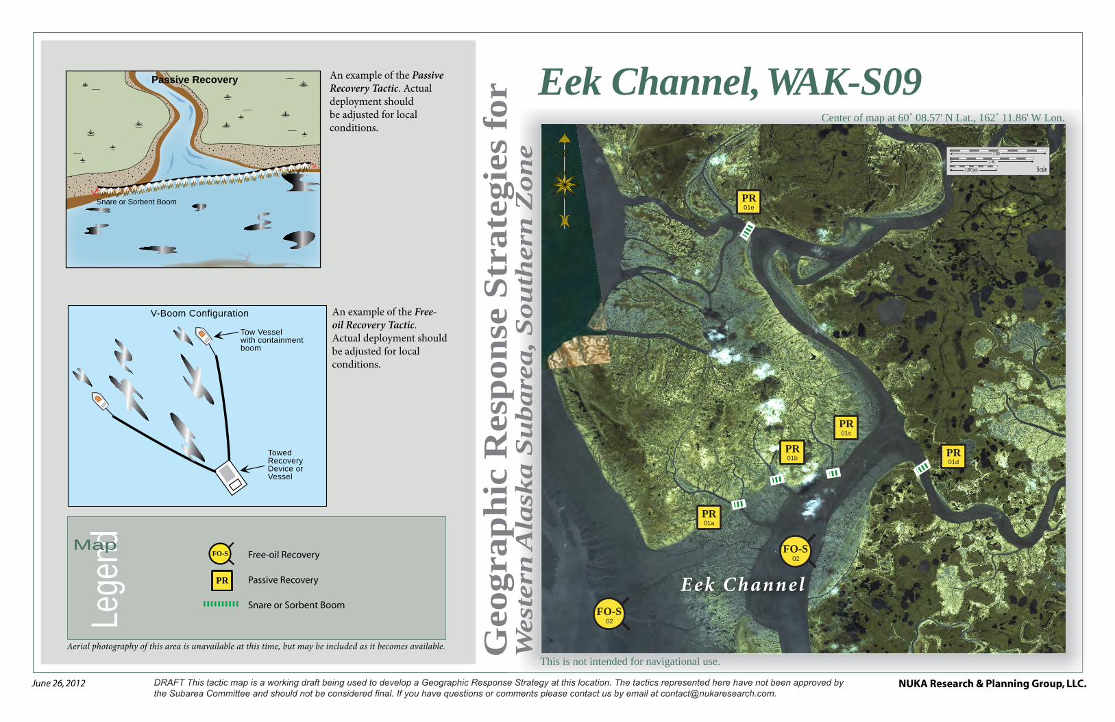
FO-S02
FO-S02
01ePR
01dPR
01cPR
01bPR
01aPR
E ek Channel
Eek Channel, WAK-S09Center of map at 60˚ 08.57' N Lat., 162˚ 11.86' W Lon.
Lege
ndMap
Aerial photography of this area is unavailable at this time, but may be included as it becomes available.
An example of the Free-oil Recovery Tactic. Actual deployment should be adjusted for local conditions.
An example of the Passive Recovery Tactic. Actual deployment should be adjusted for local conditions.
Snare or Sorbent Boom
Passive Recovery
V-Boom Configuration
Tow Vessel with containment boom
Towed Recovery Device or Vessel
Free-oil Recovery
Passive Recovery
Snare or Sorbent Boom
PR
FO-S
NUKA Research & Planning Group, LLC.NOTE: Sensitive resource information can be found on other maps which can be accessed through the sensitive area section of the Western Alaska Subarea Contingency Plan: http://dec.alaska.gov/spar/perp/plans/scp_wak.htm.
Site
Inf
orm
atio
n fo
r W
este
rn A
lask
a, W
AK
-S09
Western Alaska Subarea Geographic Response Strategies DRAFT June 2012
WAK-S09
ID Location and Description Response Strategy Implementation Response Resources Staging Area Site Access
Resources Protected (months)
Special Considerations
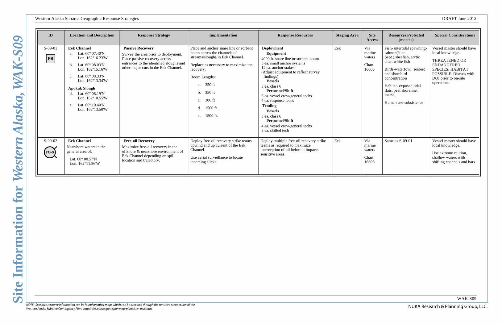
S-09-01
PR
Eek Channel a. Lat. 60º 07.40'N
Lon. 162º16.23'W
b. Lat. 60º 08.03'N Lon. 162º15.16'W
c. Lat. 60º 08.33'N Lon. 162º13.34'W
Apokak Slough d. Lat. 60º 08.19'N
Lon. 162º10.55'W
e. Lat. 60º 10.40'N Lon. 162º13.50'W
Passive Recovery
Survey the area prior to deployment. Place passive recovery across entrances to the identified sloughs and other major cuts in the Eek Channel.
Place and anchor snare line or sorbent boom across the channels of streams/sloughs in Eek Channel.
Replace as necessary to maximize the recovery.
Boom Lengths:
a. 350 ft
b. 350 ft
c. 300 ft
d. 1500 ft.
e. 1500 ft.
Deployment Equipment
4000 ft. snare line or sorbent boom 3 ea. small anchor systems 12 ea. anchor stakes (Adjust equipment to reflect survey
findings) Vessels
3 ea. class 6 Personnel/Shift
6 ea. vessel crew/general techs 4 ea. response techs Tending
Vessels 3 ea. class 6
Personnel/Shift 4 ea. vessel crew/general techs 3 ea. skilled tech
Eek Via marine waters
Chart 16606
Fish- intertidal spawning- salmon(June-Sept.),sheefish, arctic char, white fish
Birds-waterfowl, seabird and shorebird concentration
Habitat- exposed tidal flats, peat shoreline, marsh,
Human use-subsistence
Vessel master should have local knowledge.
THREATENED OR ENDANGERED SPECIES/ HABITAT POSSIBLE. Discuss with DOI prior to on-site operations.
S-09-02
FO-S
Eek Channel
Nearshore waters in the general area of:
Lat. 60° 08.57'N Lon. 162°11.86'W
Free-oil Recovery
Maximize free-oil recovery in the offshore & nearshore environment of Eek Channel depending on spill location and trajectory.
Deploy free-oil recovery strike teams upwind and up current of the Eek Channel.
Use aerial surveillance to locate incoming slicks.
Deploy multiple free-oil recovery strike teams as required to maximize interception of oil before it impacts sensitive areas.
Eek Via marine waters
Chart 16606
Same as S-09-01 Vessel master should have local knowledge.
Use extreme caution, shallow waters with shifting channels and bars.
This is not intended for navigational use.
Geo
gra
ph
ic R
esp
on
se S
trate
gie
s fo
rW
est
ern
Ala
ska S
ubare
a, S
ou
thern
Zon
e
NUKA Research & Planning Group, LLC.June 26, 2012
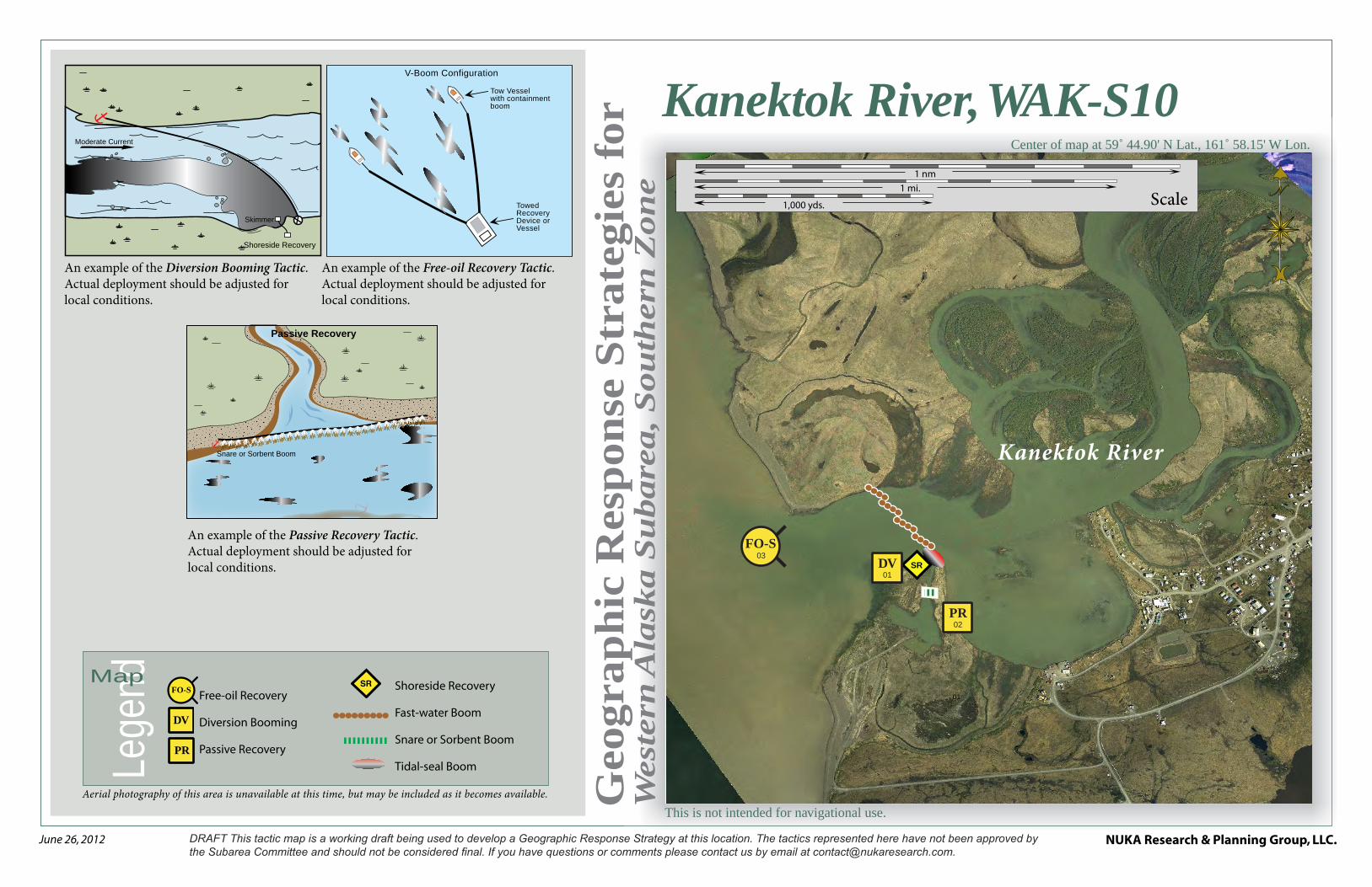
1,000 yds.
1 mi.1 nm
Scale
01
SR
FO-S03
02PR
01DV
Kanektok River
Kanektok River, WAK-S10Center of map at 59˚ 44.90' N Lat., 161˚ 58.15' W Lon.
Lege
ndMap
Aerial photography of this area is unavailable at this time, but may be included as it becomes available.
An example of the Free-oil Recovery Tactic. Actual deployment should be adjusted for local conditions.
An example of the Passive Recovery Tactic. Actual deployment should be adjusted for local conditions.
An example of the Diversion Booming Tactic. Actual deployment should be adjusted for local conditions.
V-Boom Configuration
Tow Vessel with containment boom
Towed Recovery Device or Vessel
Moderate Current
Shoreside Recovery
Skimmer
Snare or Sorbent Boom
Passive Recovery
Free-oil Recovery
Diversion Booming
Passive Recovery
DV
SR
PR
FO-S Shoreside Recovery
Fast-water Boom
Snare or Sorbent Boom
Tidal-seal Boom

NUKA Research & Planning Group, LLC.NOTE: Sensitive resource information can be found on other maps which can be accessed through the sensitive area section of the Western Alaska Subarea Contingency Plan: http://dec.alaska.gov/spar/perp/plans/scp_wak.htm.
Site
Inf
orm
atio
n fo
r W
este
rn A
lask
a, W
AK
-S10
Western Alaska Subarea Geographic Response Strategies DRAFT June 2012
WAK-S10
ID Location and Description Response Strategy Implementation Response Resources Staging Area Site Access
Resources Protected (months)
Special Considerations
S-10-01
DV
Kanektok River
Lat. 59º 44.95'N Lon. 161º55.43'W
Divert and Collect
Divert oil to shore side collection location on the shore of the Kanektok River.
Deploy anchors and boom with skiffs (class 6).
Place 4 x 300 foot section of fast-water boom in a cascaded pattern at the proper angle to divert incoming oil to the collection sites. Complete the array with 60 ft. of tidal seal boom on the shore that will be used as a collection site.
Set up shore-side recovery and tend throughout the tide.
Deployment Equipment
1200 ft. fast-water boom 60 ft. tidal seal boom 12 ea. anchor systems 4 ea. anchor stakes 1 ea. shore-side recovery systems
Vessels 2 ea. class 6
Personnel/Shift 4 ea. vessel crew/general techs 2 ea. response techs Tending
Vessels 1 ea. class 6
Personnel/Shift 2 ea. vessel crew/general techs 1 ea. skilled tech
Quinhagak Via marine waters
Chart 16300
Fish- intertidal spawning- salmon(June-Sept.)herring,sheefish, arctic char, white fish
Birds-waterfowl, seabird and shorebird concentration
Habitat- exposed tidal flats, peat shoreline, marsh,
Human use-subsistence
Vessel master should have local knowledge.
Title 41 permitting required from ADNR.
THREATENED OR ENDANGERED SPECIES/ HABITAT POSSIBLE. Discuss with DOI prior to on-site operations.
Use appropriate measures as outlined in the STAR manual to protect the shoreline.
Surveyed: not yet
Tested: not yet
S-10-02
PR
Kanektok River
Lat. 59º 44.88'N Lon. 161º55.49'W
Passive Recovery
Survey the area prior to deployment. Place passive recovery across entrances to the identified slough next to the Kanektok River.
Place and anchor snare line or sorbent boom across the channels of streams/sloughs in Kanektok River.
Replace as necessary to maximize the recovery.
Deployment Equipment
100 ft. snare line or sorbent boom 1 ea. small anchor systems 4 ea. anchor stakes (Adjust equipment to reflect survey
findings) Vessels/Personnel/Shift
Same as S-10-01 Tending
Vessels/Personnel/Shift Same as S-10-01
Quinhagak Via marine waters
Chart 16300
Same as S-10-01 Vessel master should have local knowledge.
S-10-03
FO-S
Kanektok River
Nearshore waters in the general area of:
Lat. 59° 44.90'N Lon. 161°58.15'W
Free-oil Recovery
Maximize free-oil recovery in the offshore & nearshore environment of Kanektok River depending on spill location and trajectory.
Deploy free-oil recovery strike teams upwind and up current of the Kanektok River.
Use aerial surveillance to locate incoming slicks.
Deploy multiple free-oil recovery strike teams as required to maximize interception of oil before it impacts sensitive areas.
Quinhagak Via marine waters
Chart 16300
Same as S-10-01 Vessel master should have local knowledge.
Use extreme caution, shallow waters with shifting channels and bars.

This is not intended for navigational use.
Geo
gra
ph
ic R
esp
on
se S
trate
gie
s fo
rW
est
ern
Ala
ska S
ubare
a, S
ou
thern
Zon
e
NUKA Research & Planning Group, LLC.June 26, 2012
1 nm
1 mi.
1,000 yds. Scale
FO-S03
FO-S03
01aEX
01bEX
02bPR
02aPR
Carter Bay
Carter Bay, WAK-S11Center of map at 59˚ 18.39' N Lat., 161˚ 58.68' W Lon.
Lege
ndMap
Aerial photography of this area is unavailable at this time, but may be included as it becomes available.
An example of the Free-oil Recovery Tactic. Actual deployment should be adjusted for local conditions.
An example of the Exclusion Booming Tactic. Actual deployment should be adjusted for local conditions.
An example of the Passive Recovery Tactic. Actual deployment should be adjusted for local conditions.
V-Boom Configuration
Tow Vessel with containment boom
Towed Recovery Device or Vessel
Snare or Sorbent Boom
Passive Recovery
Freshwater Outflow
Deadman Anchor
Tidal-seal Boom
Tidal-seal Boom
Containment Boom
Anchors
Directio
n of Slick
Movement
Sensitive Habitat
Free-oil Recovery
Passive Recovery
Exclusion Booming
FO-S
Fast-water Boom
Tidal-seal BoomEX
PR

NUKA Research & Planning Group, LLC.NOTE: Sensitive resource information can be found on other maps which can be accessed through the sensitive area section of the Western Alaska Subarea Contingency Plan: http://dec.alaska.gov/spar/perp/plans/scp_wak.htm.
Site
Inf
orm
atio
n fo
r W
este
rn A
lask
a, W
AK
-S11
Western Alaska Subarea Geographic Response Strategies DRAFT June 2012
WAK-S11
ID Location and Description Response Strategy Implementation Response Resources Staging Area Site Access
Resources Protected (months)
Special Considerations
S-11-01
EX
Carter Bay a. Lat. 59º 17.39'N
Lon. 161º56.64'W
b. Lat. 59º 17.12'N Lon. 161º56.64'W
Exclusion
Exclude oil from impacting the identified streams and intertidal area in Carter Bay.
Deploy anchors and boom with skiffs (class 6) at high tide.
Place 500 ft. of fast-water boom in a chevron pattern in front of each entrance to the streams. Complete the arrays by placing 60 ft. of tidal seal boom on each leg.
Tend throughout the tide.
Deployment Equipment
1000 ft. fast-water boom 240 ft. tidal seal boom 6 ea. anchor systems 8 ea. anchor stakes
Vessels 1 ea. class 3 2 ea. class 6
Personnel/Shift 7 ea. vessel crew/general techs Tending
Vessels 1 ea. class 3 1 ea. class 6
Personnel/Shift 4 ea. vessel crew/general techs
Vessel Platform
Via marine waters
Chart 16300
Fish- intertidal spawning- salmon, herring (June-Sept.)
Birds-waterfowl, seabird and shorebird concentration
Habitat- exposed tidal flats, peat shoreline, marsh,
Human use-subsistence, commercial fishing
Vessel master should have local knowledge.
Title 41 permitting required from ADNR.
THREATENED OR ENDANGERED SPECIES/ HABITAT POSSIBLE. Discuss with DOI prior to on-site operations.
Surveyed: not yet
Tested: not yet
S-11-02
PR
Carter Bay a. Lat. 60º 10.89'N
Lon. 164º28.69'W
b. Lat. 59° 15.69’N Lon. 161°56.58'W
Passive Recovery
Survey the area prior to deployment. Place passive recovery across entrances to the identified sloughs and other major cuts in the Carter Bay.
Place and anchor snare line or sorbent boom across the channels of streams/sloughs in Carter Bay.
Replace as necessary to maximize the recovery.
Boom Lengths:
a. 500 ft
b. 500 ft
Deployment Equipment
1000 ft. snare line or sorbent boom 4 ea. small anchor systems 8 ea. anchor stakes (Adjust equipment to reflect survey
findings) Vessels/Personnel/Shift
Same as S-11-01 Tending
Vessels/Personnel/Shift Same as S-11-01
Vessel Platform
Via marine waters
Chart 16300
Same as S-11-01 Vessel master should have local knowledge.
S-11-03
FO-S
Carter Bay
Nearshore waters in the general area of:
Lat. 59° 18.39'N Lon. 161°58.68'W
Free-oil Recovery
Maximize free-oil recovery in the offshore & nearshore environment of Carter Bay depending on spill location and trajectory.
Deploy free-oil recovery strike teams upwind and up current of the Carter Bay.
Use aerial surveillance to locate incoming slicks.
Deploy multiple free-oil recovery strike teams as required to maximize interception of oil before it impacts sensitive areas.
Platinum Via marine waters
Chart 16300
Same as S-11-01 Vessel master should have local knowledge.
Use extreme caution, shallow waters with shifting channels and bars.

This is not intended for navigational use.
Geo
gra
ph
ic R
esp
on
se S
trate
gie
s fo
rW
est
ern
Ala
ska S
ubare
a, S
ou
thern
Zon
e
NUKA Research & Planning Group, LLC.June 26, 2012
Goodnews Bay, WAK-S12Center of map at 59˚ 04.04' N Lat., 161˚ 46.35' W Lon.
Scale
5 nm5 mi.
5,000 yds.
FO-S03
FO-S03
02bEX
01aDF
01bDF
02aEX
Goodnews Bay
Lege
ndMap
Aerial photography of this area is unavailable at this time, but may be included as it becomes available.
An example of the Free-oil Recovery Tactic. Actual deployment should be adjusted for local conditions.
An example of the Exclusion Booming Tactic. Actual deployment should be adjusted for local conditions.
An example of the Deflection Booming Tactic. Actual deployment should be adjusted for local conditions.
V-Boom Configuration
Tow Vessel with containment boom
Towed Recovery Device or Vessel
Freshwater Outflow
Deadman Anchor
Tidal-seal Boom
Tidal-seal Boom
Containment Boom
Anchors
Directio
n of Slick
Movement
Sensitive Habitat
Free-oil Recovery
Deflection Booming
Exclusion Recovery
FO-S
Fast-water Boom
Tidal-seal BoomDF
EX
Deflection Boom
Anchor System
wind
curre
nt
Slick
NUKA Research & Planning Group, LLC.NOTE: Sensitive resource information can be found on other maps which can be accessed through the sensitive area section of the Western Alaska Subarea Contingency Plan: http://dec.alaska.gov/spar/perp/plans/scp_wak.htm.
Site
Inf
orm
atio
n fo
r W
este
rn A
lask
a, W
AK
-S12
Western Alaska Subarea Geographic Response Strategies DRAFT June 2012
WAK-S12
ID Location and Description Response Strategy Implementation Response Resources Staging Area Site Access Resources Protected (months)
Special Considerations
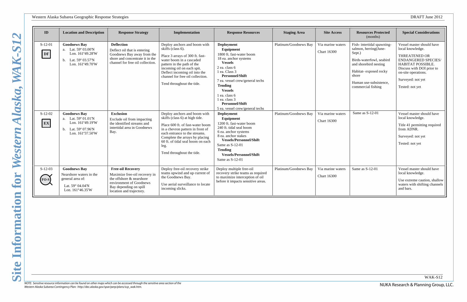
S-12-01
Goodnews Bay a. Lat. 59º 03.00'N
Lon. 161º49.28'W
b. Lat. 59º 03.57'N Lon. 161º49.70'W
Deflection
Deflect oil that is entering Goodnews Bay away from the shore and concentrate it in the channel for free oil collection.
Deploy anchors and boom with skiffs (class 6).
Place 3 arrays of 300 ft. fast-water boom in a cascaded pattern in the path of the incoming oil on each spit. Deflect incoming oil into the channel for free oil collection.
Tend throughout the tide.
Deployment Equipment
1800 ft. fast-water boom 18 ea. anchor systems
Vessels 2 ea. class 6 1 ea. Class 3
Personnel/Shift 7 ea. vessel crew/general techs Tending
Vessels 1 ea. class 6 1 ea. class 3
Personnel/Shift 5 ea. vessel crew/general techs
Platinum/Goodnews Bay Via marine waters
Chart 16300
Fish- intertidal spawning- salmon, herring(June-Sept.)
Birds-waterfowl, seabird and shorebird nesting
Habitat- exposed rocky shore
Human use-subsistence, commercial fishing
Vessel master should have local knowledge.
THREATENED OR ENDANGERED SPECIES/ HABITAT POSSIBLE. Discuss with DOI prior to on-site operations.
Surveyed: not yet
Tested: not yet
S-12-02
EX
Goodnews Bay a. Lat. 59º 01.01'N
Lon. 161º49.19'W
b. Lat. 59º 07.96'N Lon. 161º37.50'W
Exclusion
Exclude oil from impacting the identified streams and intertidal area in Goodnews Bay.
Deploy anchors and boom with skiffs (class 6) at high tide.
Place 600 ft. of fast-water boom in a chevron pattern in front of each entrance to the streams. Complete the arrays by placing 60 ft. of tidal seal boom on each leg.
Tend throughout the tide.
Deployment Equipment
1200 ft. fast-water boom 240 ft. tidal seal boom 6 ea. anchor systems 8 ea. anchor stakes
Vessels/Personnel/Shift Same as S-12-01 Tending
Vessels/Personnel/Shift Same as S-12-01
Platinum/Goodnews Bay Via marine waters
Chart 16300
Same as S-12-01
Vessel master should have local knowledge.
Title 41 permitting required from ADNR.
Surveyed: not yet
Tested: not yet
S-12-03
FO-S
Goodnews Bay
Nearshore waters in the general area of:
Lat. 59° 04.04'N Lon. 161°46.35'W
Free-oil Recovery
Maximize free-oil recovery in the offshore & nearshore environment of Goodnews Bay depending on spill location and trajectory.
Deploy free-oil recovery strike teams upwind and up current of the Goodnews Bay.
Use aerial surveillance to locate incoming slicks.
Deploy multiple free-oil recovery strike teams as required to maximize interception of oil before it impacts sensitive areas.
Platinum/Goodnews Bay Via marine waters
Chart 16300
Same as S-12-01 Vessel master should have local knowledge.
Use extreme caution, shallow waters with shifting channels and bars.

This is not intended for navigational use.
Geo
gra
ph
ic R
esp
on
se S
trate
gie
s fo
rW
est
ern
Ala
ska S
ubare
a, S
ou
thern
Zon
e
NUKA Research & Planning Group, LLC.June 26, 2012
Scale
1 nm1 mi.
1,000 yds.
FO-S02
FO-S02
01alt.EX
01EX
Salmon River
Salmon River, WAK-S13Center of map at 58˚ 51.39' N Lat., 161˚ 47.97' W Lon.
Lege
ndMap
Aerial photography of this area is unavailable at this time, but may be included as it becomes available.
An example of the Free-oil Recovery Tactic. Actual deployment should be adjusted for local conditions.
An example of the Passive Recovery Tactic. Actual deployment should be adjusted for local conditions.
Freshwater Outflow
Deadman Anchor
Tidal-seal Boom
Tidal-seal Boom
Containment Boom
Anchors
Directio
n of Slick
Movement
Sensitive Habitat
V-Boom Configuration
Tow Vessel with containment boom
Towed Recovery Device or Vessel
Free-oil Recovery
Exclusion Booming
Fast-water Boom
Tidal-seal Boom
FO-S
EX
NUKA Research & Planning Group, LLC.NOTE: Sensitive resource information can be found on other maps which can be accessed through the sensitive area section of the Western Alaska Subarea Contingency Plan: http://dec.alaska.gov/spar/perp/plans/scp_wak.htm.
Site
Inf
orm
atio
n fo
r W
este
rn A
lask
a, W
AK
-S13
Western Alaska Subarea Geographic Response Strategies DRAFT June 2012
WAK-S13
ID Location and Description Response Strategy Implementation Response Resources Staging Area Site Access Resources Protected (months)
Special Considerations
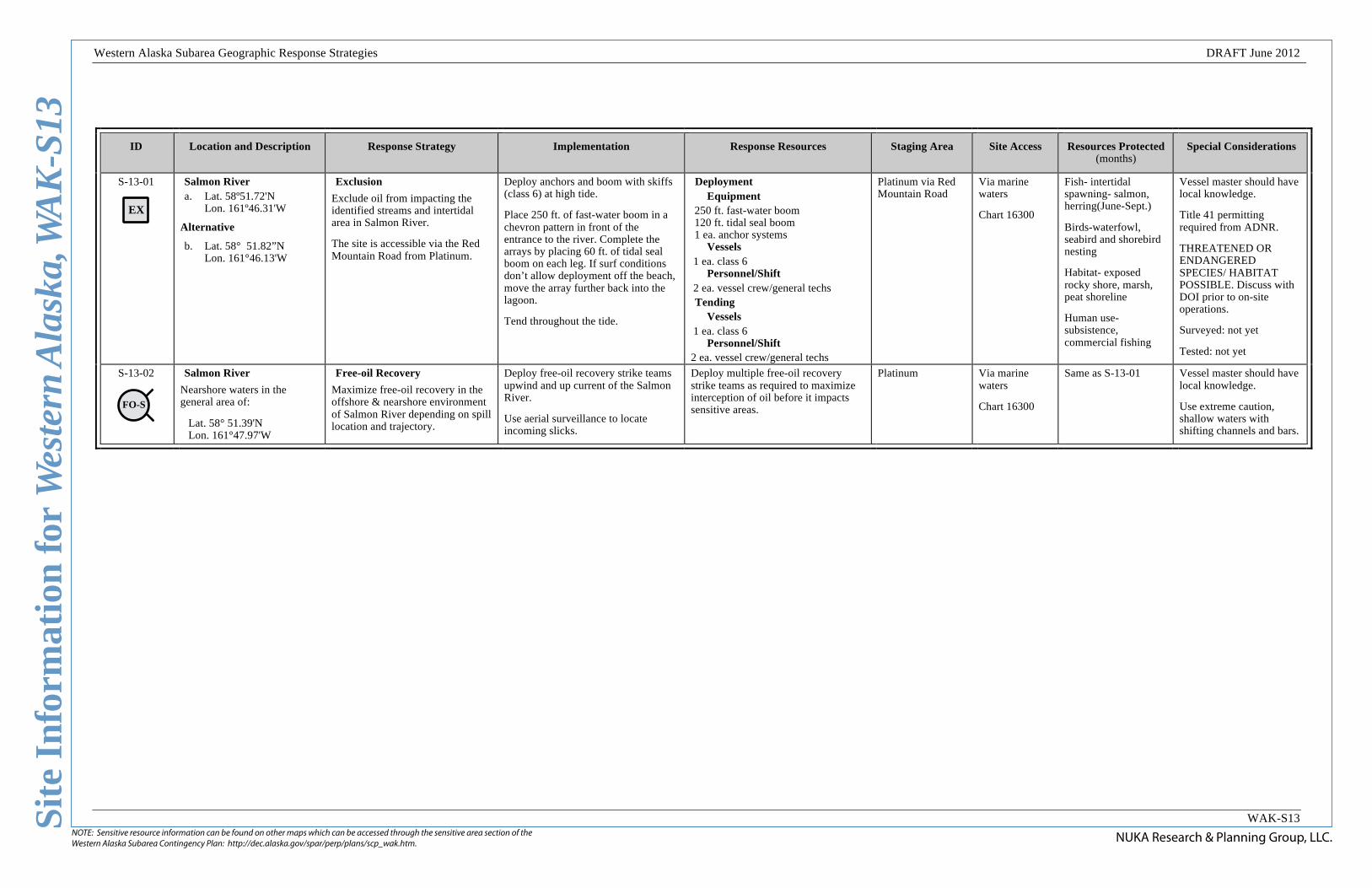
S-13-01
EX
Salmon River a. Lat. 58º51.72'N
Lon. 161º46.31'W
Alternative
b. Lat. 58° 51.82”N Lon. 161°46.13'W
Exclusion
Exclude oil from impacting the identified streams and intertidal area in Salmon River.
The site is accessible via the Red Mountain Road from Platinum.
Deploy anchors and boom with skiffs (class 6) at high tide.
Place 250 ft. of fast-water boom in a chevron pattern in front of the entrance to the river. Complete the arrays by placing 60 ft. of tidal seal boom on each leg. If surf conditions don’t allow deployment off the beach, move the array further back into the lagoon.
Tend throughout the tide.
Deployment Equipment
250 ft. fast-water boom 120 ft. tidal seal boom 1 ea. anchor systems
Vessels 1 ea. class 6
Personnel/Shift 2 ea. vessel crew/general techs Tending
Vessels 1 ea. class 6
Personnel/Shift 2 ea. vessel crew/general techs
Platinum via Red Mountain Road
Via marine waters
Chart 16300
Fish- intertidal spawning- salmon, herring(June-Sept.)
Birds-waterfowl, seabird and shorebird nesting
Habitat- exposed rocky shore, marsh, peat shoreline
Human use-subsistence, commercial fishing
Vessel master should have local knowledge.
Title 41 permitting required from ADNR.
THREATENED OR ENDANGERED SPECIES/ HABITAT POSSIBLE. Discuss with DOI prior to on-site operations.
Surveyed: not yet
Tested: not yet
S-13-02
FO-S
Salmon River
Nearshore waters in the general area of:
Lat. 58° 51.39'N Lon. 161°47.97'W
Free-oil Recovery
Maximize free-oil recovery in the offshore & nearshore environment of Salmon River depending on spill location and trajectory.
Deploy free-oil recovery strike teams upwind and up current of the Salmon River.
Use aerial surveillance to locate incoming slicks.
Deploy multiple free-oil recovery strike teams as required to maximize interception of oil before it impacts sensitive areas.
Platinum Via marine waters
Chart 16300
Same as S-13-01 Vessel master should have local knowledge.
Use extreme caution, shallow waters with shifting channels and bars.
This is not intended for navigational use.
Geo
gra
ph
ic R
esp
on
se S
trate
gie
s fo
rW
est
ern
Ala
ska S
ubare
a, S
ou
thern
Zon
e
NUKA Research & Planning Group, LLC.June 26, 2012
Scale
1 nm1 mi.
1,000 yds.
FO-S03
01aDV
01bDV
02aPR
02bPR
02cPRChagvan Bay
SR
SR
Chagvan Bay, WAK-S14Center of map at 58˚ 46.29' N Lat., 161˚ 47.43' W Lon.
Lege
ndMap
Aerial photography of this area is unavailable at this time, but may be included as it becomes available.
An example of the Free-oil Recovery Tactic. Actual deployment should be adjusted for local conditions.
An example of the Passive Recovery Tactic. Actual deployment should be adjusted for local conditions.
An example of the Diversion Booming Tactic. Actual deployment should be adjusted for local conditions.
V-Boom Configuration
Tow Vessel with containment boom
Towed Recovery Device or Vessel
Moderate Current
Shoreside Recovery
Skimmer
Snare or Sorbent Boom
Passive Recovery
Free-oil Recovery
Diversion Booming
Passive Recovery
DV
SR
PR
FO-S Shoreside Recovery
Protected-water Boom
Snare or Sorbent Boom
NUKA Research & Planning Group, LLC.NOTE: Sensitive resource information can be found on other maps which can be accessed through the sensitive area section of the Western Alaska Subarea Contingency Plan: http://dec.alaska.gov/spar/perp/plans/scp_wak.htm.
Site
Inf
orm
atio
n fo
r W
este
rn A
lask
a, W
AK
-S14
Western Alaska Subarea Geographic Response Strategies DRAFT June 2012
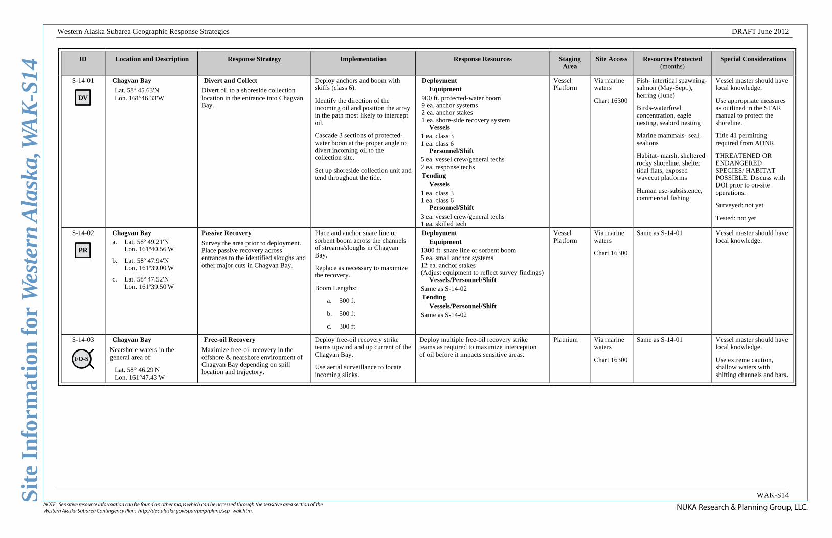
WAK-S14
ID Location and Description Response Strategy Implementation Response Resources Staging Area
Site Access Resources Protected (months)
Special Considerations
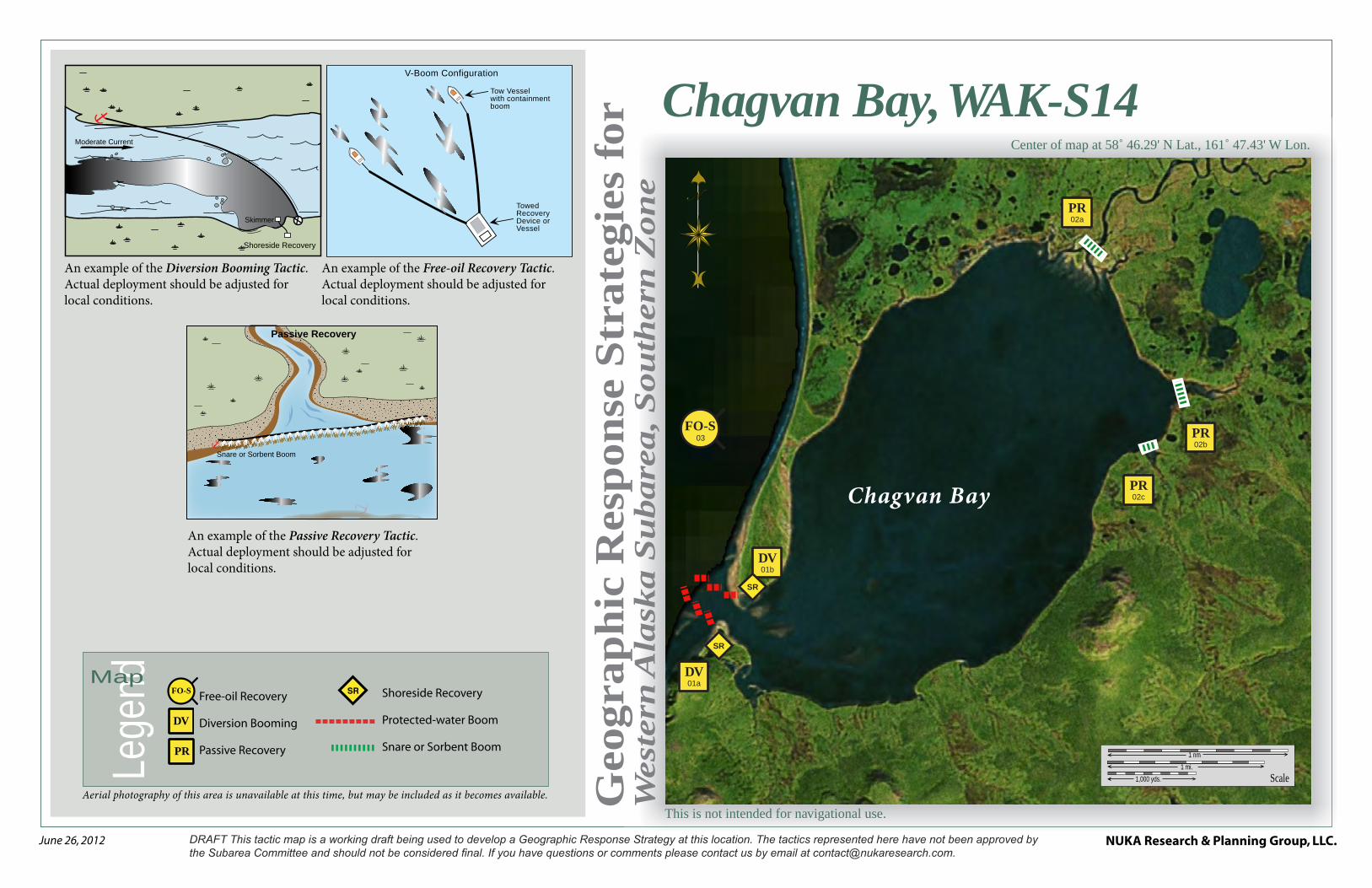
S-14-01
DV
Chagvan Bay
Lat. 58º 45.63'N Lon. 161º46.33'W
Divert and Collect
Divert oil to a shoreside collection location in the entrance into Chagvan Bay.
Deploy anchors and boom with skiffs (class 6).
Identify the direction of the incoming oil and position the array in the path most likely to intercept oil.
Cascade 3 sections of protected-water boom at the proper angle to divert incoming oil to the collection site.
Set up shoreside collection unit and tend throughout the tide.
Deployment Equipment
900 ft. protected-water boom 9 ea. anchor systems 2 ea. anchor stakes 1 ea. shore-side recovery system
Vessels 1 ea. class 3 1 ea. class 6
Personnel/Shift 5 ea. vessel crew/general techs 2 ea. response techs Tending
Vessels 1 ea. class 3 1 ea. class 6
Personnel/Shift 3 ea. vessel crew/general techs 1 ea. skilled tech
Vessel Platform
Via marine waters
Chart 16300
Fish- intertidal spawning- salmon (May-Sept.), herring (June)
Birds-waterfowl concentration, eagle nesting, seabird nesting
Marine mammals- seal, sealions
Habitat- marsh, sheltered rocky shoreline, shelter tidal flats, exposed wavecut platforms
Human use-subsistence, commercial fishing
Vessel master should have local knowledge.
Use appropriate measures as outlined in the STAR manual to protect the shoreline.
Title 41 permitting required from ADNR.
THREATENED OR ENDANGERED SPECIES/ HABITAT POSSIBLE. Discuss with DOI prior to on-site operations.
Surveyed: not yet
Tested: not yet
S-14-02
PR
Chagvan Bay a. Lat. 58º 49.21'N
Lon. 161º40.56'W
b. Lat. 58º 47.94'N Lon. 161º39.00'W
c. Lat. 58º 47.52'N Lon. 161º39.50'W
Passive Recovery
Survey the area prior to deployment. Place passive recovery across entrances to the identified sloughs and other major cuts in Chagvan Bay.
Place and anchor snare line or sorbent boom across the channels of streams/sloughs in Chagvan Bay.
Replace as necessary to maximize the recovery.
Boom Lengths:
a. 500 ft
b. 500 ft
c. 300 ft
Deployment Equipment
1300 ft. snare line or sorbent boom 5 ea. small anchor systems 12 ea. anchor stakes (Adjust equipment to reflect survey findings)
Vessels/Personnel/Shift Same as S-14-02 Tending
Vessels/Personnel/Shift Same as S-14-02
Vessel Platform
Via marine waters
Chart 16300
Same as S-14-01 Vessel master should have local knowledge.
S-14-03
FO-S
Chagvan Bay
Nearshore waters in the general area of:
Lat. 58° 46.29'N Lon. 161°47.43'W
Free-oil Recovery
Maximize free-oil recovery in the offshore & nearshore environment of Chagvan Bay depending on spill location and trajectory.
Deploy free-oil recovery strike teams upwind and up current of the Chagvan Bay.
Use aerial surveillance to locate incoming slicks.
Deploy multiple free-oil recovery strike teams as required to maximize interception of oil before it impacts sensitive areas.
Platnium Via marine waters
Chart 16300
Same as S-14-01 Vessel master should have local knowledge.
Use extreme caution, shallow waters with shifting channels and bars.

This is not intended for navigational use.
Geo
gra
ph
ic R
esp
on
se S
trate
gie
s fo
rW
est
ern
Ala
ska S
ubare
a, S
ou
thern
Zon
e
NUKA Research & Planning Group, LLC.June 26, 2012
Scale
1 nm1 mi.
1,000 yds.
FO-S03
FO-S03
02DF
01EX
Security Cove
Security Cove, WAK-S15Center of map at 58˚ 41.24' N Lat., 161˚ 54.85' W Lon.
Lege
ndMap
Aerial photography of this area is unavailable at this time, but may be included as it becomes available.
An example of the Free-oil Recovery Tactic. Actual deployment should be adjusted for local conditions.
An example of the Deflection Live Booming Tactic. Actual deployment should be adjusted for local conditions.
An example of the Exclusion Booming Tactic. Actual deployment should be adjusted for local conditions.
V-Boom Configuration
Tow Vessel with containment boom
Towed Recovery Device or Vessel
Free-oil Recovery
Deflection Booming, Live
Exclusion Booming
FO-S
EX
Protected-water Boom
Tidal-seal Boom
Deflection Boom
Anchor System
wind
curre
nt
Slick
Freshwater Outflow
Deadman Anchor
Tidal-seal Boom
Tidal-seal Boom
Containment Boom
Anchors
Directio
n of Slick
Movement
Sensitive Habitat
DF-L

NUKA Research & Planning Group, LLC.NOTE: Sensitive resource information can be found on other maps which can be accessed through the sensitive area section of the Western Alaska Subarea Contingency Plan: http://dec.alaska.gov/spar/perp/plans/scp_wak.htm.
Site
Inf
orm
atio
n fo
r W
este
rn A
lask
a, W
AK
-S15
Western Alaska Subarea Geographic Response Strategies DRAFT June 2012
WAK-S15
ID Location and Description Response Strategy Implementation Response Resources Staging Area
Site Access Resources Protected (months)
Special Considerations
S-15-01
EX
Security Cove
Lat. 58º 39.76'N Lon. 161º52.10'W
Exclusion
Exclude oil from impacting the identified streams and intertidal area in Security Cove.
The site is accessible via the Red Mountain Road from Platinum.
Deploy anchors and boom with skiffs (class 6) at high tide.
Place 250 ft. of protected-water boom in a chevron pattern in front of the entrance to the river. Complete the arrays by placing 60 ft. of tidal seal boom on each leg. If surf conditions don’t allow deployment off the beach, move the array further back into the lagoon.
Tend throughout the tide.
Deployment Equipment
250 ft. protected-water boom 120 ft. tidal seal boom 1 ea. anchor systems
Vessels 1 ea. class 6
Personnel/Shift 2 ea. vessel crew/general techs Tending
Vessels 1 ea. class 6
Personnel/Shift 2 ea. vessel crew/general techs
Vessel Platform
Via marine waters
Chart 16300
Fish- intertidal spawning-herring (June)
Marine mammals-seals, sealion
Birds-waterfowl, seabird and shorebird nesting
Habitat- exposed rocky shore, marsh, peat shoreline
Human use-subsistence, commercial fishing
Vessel master should have local knowledge.
Title 41 permitting required from ADNR.
THREATENED OR ENDANGERED SPECIES/ HABITAT POSSIBLE. Discuss with DOI prior to on-site operations.
Surveyed: not yet
Tested: not yet
S-15-02
Security Cove
Lat. 58º 43.12'N Lon. 161º52.01'W
Exact location directed by aerial surviallance.
Deflection-Live
Deflect oil that is going to impact the haul outs and rookery in the Security Cove area away from the area and into the channel for free oil collection.
Deploy anchors and boom with skiffs (class 6).
Use aerial surveillance to identify the incoming oil and it’s direction. Using available vessels, hold in place 3 arrays of 300 ft. protected-water boom in a cascaded pattern in the path of the incoming oil. Deflect incoming oil out for free oil collection.
Tend throughout the tide.
Deployment Equipment
900 ft. protected-water boom Vessels
6 ea. class 3 Personnel/Shift
18 ea. vessel crew/general techs Tending
Vessels 6 ea. class 3
Personnel/Shift 18 ea. vessel crew/general techs
Vessel Platform
Via marine waters
Chart 16300
Same as S-15-01 Vessel master should have local knowledge.
Surveyed: not yet
Tested: not yet
S-15-03
FO-S
Security Cove
Nearshore waters in the general area of:
Lat. 58° 41.24'N Lon. 161°54.85'W
Free-oil Recovery
Maximize free-oil recovery in the offshore & nearshore environment of Security Cove depending on spill location and trajectory.
Deploy free-oil recovery strike teams upwind and up current of the Security Cove.
Use aerial surveillance to locate incoming slicks.
Deploy multiple free-oil recovery strike teams as required to maximize interception of oil before it impacts sensitive areas.
Platinum Via marine waters
Chart 16300
Same as S-15-01 Vessel master should have local knowledge.
Use extreme caution, shallow waters with shifting channels and bars.

This is not intended for navigational use.
Geo
gra
ph
ic R
esp
on
se S
trate
gie
s fo
rW
est
ern
Ala
ska S
ubare
a, S
ou
thern
Zon
e
NUKA Research & Planning Group, LLC.June 26, 2012
Nanvak Bay, WAK-S16Center of map at 58˚ 34.51' N Lat., 161˚ 46.36' W Lon.
Scale
1 nm1 mi.
1,000 yds.
01
SR
FO-S03
02DV
02aPR
02cPR
02bPR
02dPR
02ePR
Nanvak Bay
Lege
ndMap
Aerial photography of this area is unavailable at this time, but may be included as it becomes available.
An example of the Free-oil Recovery Tactic. Actual deployment should be adjusted for local conditions.
An example of the Diversion Booming Tactic. Actual deployment should be adjusted for local conditions.
An example of the Passive Recovery Tactic. Actual deployment should be adjusted for local conditions.
V-Boom Configuration
Tow Vessel with containment boom
Towed Recovery Device or Vessel
Free-oil Recovery
Diversion Booming
Passive Recovery
FO-SShoreside Recovery
Protected-water Boom
Snare or Sorbent Boom
Tidal-seal Boom
Moderate Current
Shoreside Recovery
Skimmer
Freshwater Outflow
Deadman Anchor
Tidal-seal Boom
Tidal-seal Boom
Containment Boom
Anchors
Directio
n of Slick
Movement
Sensitive Habitat
DV
PR
SR

NUKA Research & Planning Group, LLC.NOTE: Sensitive resource information can be found on other maps which can be accessed through the sensitive area section of the Western Alaska Subarea Contingency Plan: http://dec.alaska.gov/spar/perp/plans/scp_wak.htm.
Site
Inf
orm
atio
n fo
r W
este
rn A
lask
a, W
AK
-S16
Western Alaska Subarea Geographic Response Strategies DRAFT June 2012
WAK-S16
ID Location and Description Response Strategy Implementation Response Resources Staging Area Site Access
Resources Protected (months)
Special Considerations
S-16-01
DV
Nanvak Bay
Lat. 58º 34.81'N Lon. 161º45.05'W
Divert and Collect
Divert oil to shore side collection location on the shore of the spit forming Nanvak Bay.
Deploy anchors and boom with skiffs (class 6).
Identify the direction of the incoming oil and position the array in the path most likely to intercept oil.
Cascade 3 sections of protected-water boom at the proper angle to divert incoming oil to the collection site. Complete the arrays with a 60-foot section of tidal-seal boom.
Set up shore-side collection unit and tend throughout the tide.
Deployment Equipment
900 ft. protected-water boom 60 ft. tidal-seal boom 9 ea. anchor systems 2 ea. anchor stakes 1 ea. shore-side recovery system
Vessels 1 ea. class 3 1 ea. class 6
Personnel/Shift 5 ea. vessel crew/general techs 2 ea. response techs Tending
Vessels 1 ea. class 3 1 ea. class 6
Personnel/Shift 3 ea. vessel crew/general techs 1 ea. skilled tech
Togiak Via marine waters
Chart 16305
Fish- intertidal spawning- salmon(June-Sept.)herring, sheefish, arctic char, white fish
Marine mammals-seals
Birds-waterfowl, seabird and shorebird concentration
Habitat- sheltered tidal flats, peat shoreline, marsh,
Human use-subsistence, commercial fishing
Vessel master should have local knowledge.
Title 41 permitting required from ADNR.
THREATENED OR ENDANGERED SPECIES/ HABITAT POSSIBLE. Discuss with DOI prior to on-site operations.
Surveyed: not yet
Tested: not yet
S-16-02
PR
Nanvak Bay
a. Lat. 58º 38.21'N
Lon. 161º44.25'W
b. Lat. 58º 36.61'N Lon. 161°46.66'W
c. Lat. 58º 36.10'N Lon. 161º46.08'W
d. Lat. 58º 35.40'N Lon. 161º45.59'W
e. Lat. 58º 35.25'N Lon. 161º45.44'W
Passive Recovery
Survey the area prior to deployment. Place passive recovery across entrances to the identified slough next to the Nanvak Bay.
Place and anchor snare line or sorbent boom across the channels of streams at the back of the bay. Place the remaining arrays at the breaks in the spit that creates Nanvak Bay.
Replace as necessary to maximize the recovery.
Boom Lengths:
a. 600 ft
b. 400 ft
c. 300 ft
d. 500 ft
e. 300 ft
Deployment Equipment
2100 ft. snare line or sorbent boom 8 ea. small anchor systems 20ea. anchor stakes (Adjust equipment to reflect survey
findings) Vessels/Personnel/Shift
Same as S-16-01 Tending
Vessels/Personnel/Shift Same as S-16-01
Togiak Via marine waters
Chart 16305
Same as S-16-01 Vessel master should have local knowledge.
S-16-03
FO-S
Nanvak Bay
Nearshore waters in the general area of:
Lat. 58° 34.51'N Lon. 161°46.36'W
Free-oil Recovery
Maximize free-oil recovery in the offshore & nearshore environment of Nanvak Bay depending on spill location and trajectory.
Deploy free-oil recovery strike teams upwind and up current of the Nanvak Bay.
Use aerial surveillance to locate incoming slicks.
Deploy multiple free-oil recovery strike teams as required to maximize interception of oil before it impacts sensitive areas.
Togiak Via marine waters
Chart 16305
Same as S-16-01 Vessel master should have local knowledge.
Use extreme caution, shallow waters with shifting channels and bars.