Price Ranch Limited Phase I Environmental Site Assessment
145
Price Ranch Limited Phase I Environmental Site Assessment 183.76 Acre site along Texas State Highway 35 Gregory, San Patricio County, Texas Prepared For: Prepared By: 400 S Padre Island Dr STE 205 Corpus Christi, Texas 78405 Testengeer Project No. 20109838 December 2016
Transcript of Price Ranch Limited Phase I Environmental Site Assessment
Price Ranch Limited Phase I
Environmental Site Assessment
183.76 Acre site along Texas State Highway 35 Gregory, San Patricio County, Texas
Prepared For:
Prepared By:
400 S Padre Island Dr STE 205 Corpus Christi, Texas 78405
Testengeer Project No. 20109838
December 2016
TABLE OF CONTENTS
Page
1.0 INTRODUCTION .................................................................................................................. 1
1.1 Purpose ................................................................................................................................ 1
1.2 Special Terms and Conditions .......................................................................................... 1
1.3 General Limitations ............................................................................................................. 1
1.4 Information Sources ............................................................................................................ 1
2.0 PROPERTY DESCRIPTION ............................................................................................... 2
2.1 Location ............................................................................................................................... 2
2.2 Legal Description ................................................................................................................ 2
2.3 Property and Vicinity Characteristics ................................................................................. 2
2.4 Easements and Right of Ways ............................................................................................ 3
2.5 Title Review ........................................................................................................................ 3
2.6 Current Uses of Subject Property ....................................................................................... 3
2.7 Past Uses of Subject Property ............................................................................................. 3
2.8 Current Uses of Adjacent and Surrounding Properties ..................................................... 3
2.9 Past Uses of Adjacent and Surrounding Properties ............................................................ 3
3.0 RECORD REVIEW ............................................................................................................... 4
3.1 General ................................................................................................................................ 4
3.2 GeoSearch ........................................................................................................................... 4
3.3 Historical Aerial Photographs ............................................................................................. 7 3.3.1 Aerial Photograph-1950 (1” = 1000’±) ..................................................................... 7
3.3.2 Aerial Photograph-1961 (1” = 1000’±) ..................................................................... 8
3.3.3 Aerial Photograph-1972 (1” = 1000’±) ..................................................................... 8
3.3.4 Aerial Photograph-1984 (1” = 1000’±) ..................................................................... 8
3.3.5 Aerial Photograph-1996 (1” = 1000’±) ..................................................................... 8
3.3.6 Aerial Photograph-2004 (1” = 1000’±) ..................................................................... 8
3.3.7 Aerial Photograph-2014 (1” = 1000’±) ..................................................................... 8
3.4 Historical Topographic Maps .............................................................................................. 8
3.5 City Directories ................................................................................................................... 9
3.6 Fire Insurance Map Records ............................................................................................. 9
3.7 Environmental Liens ........................................................................................................... 9
3.8 Oil and Gas Exploration Records ........................................................................................ 9
4.0 PROPERTY RECONNAISSANCE ...................................................................................... 10
4.1 General ............................................................................................................................... 10
4.2 Observations ...................................................................................................................... 10
4.3 Interior and Exterior of Home .......................................................................................... 10
4.4 Pits, Ponds, and Lagoons .................................................................................................. 10
4.5 Stained Soils ................................................................................................................... 10
4.6 Stressed Vegetation ........................................................................................................... 10
4.7 Possible Presence of Polychlorinated Biphenyls (PCBs) ................................................. 10
4.8 Solid Waste Disposal ........................................................................................................ 10
4.9 Identification of Contaminant Migration Paths ................................................................ 10
4.10 Wastewater ........................................................................................................................ 11
4.11 Property Utilities ............................................................................................................... 11
4.12 Other Issues ....................................................................................................................... 11
5.0 INTERVIEWS ........................................................................................................................ 11
6.0 CONCLUSIONS AND RECOMMENDATIONS ................................................................ 11
FIGURES
FIGURE 1..................................................................................Subject Property Location Map
FIGURE 2 .......................................................................................Subject Property Detail Map
EXHIBITS
EXHIBIT A............................................................................................Physical Settings Report
EXHIBIT B................................................................................................... Radius Map Report
EXHIBIT C ......................................................................................................Aerial Photographs
EXHIBIT D......................................................................... Historical Topographic Map Report
EXHIBIT E. ............. ......... ........ ............................................................ City Directory Report
EXHIBIT F........................................................................................Fire Insurance Map Report
EXHIBIT G...................................................................................... Environmental Lien Search
EXHIBIT H....................................................................................................Oil and Gas Report
EXHIBIT I......................................................................................................Water Well Report
EXHIBIT J.........................................................................Railroad Commission of Texas Map
EXHIBIT K...........................................................................................................ALTA Survey
1
Introduction
Testengeer, Inc. conducted a Limited Phase 1 Environmental Site Assessment (ESA) on a 183.756-acre site along Texas State Highway (SH) 35 near Gregory, San Patricio County, Texas 78374. The Limited ESA was conducted for and authorized by Mr. Tommy Kurtz with Corpus Christi Regional Economic Development Corporation (CCREDC) and Mr. James Price, landowner.
1.1 Purpose
The Limited ESA was performed in general conformance with the requirements of the American Society for Testing Materials (ASTM) Standard Practice for Environmental Site Assessments: Phase I Environmental Site Assessment Process, Designation E1527–13 unless specifically noted in this report. This Standard Practice was developed to address the scope of the Comprehensive Environmental Response, Compensation, and Liability Act (CERCLA) in order to qualify for the innocent landowner’s defense to CERCLA liability. The purpose of this ESA was to assist the client in developing information to identify Recognized Environmental Conditions (RECs) in connection with the site as reflected by the scope of this report. This purpose was undertaken through user-provided information, a regulatory database review, and historical and physical records review. 1.2 Special Terms and Conditions
Testengeer, Inc. has performed this Limited ESA for CCREDC for the above stated purpose and therefore may not contain sufficient information for other purposes or entities. Reference is made in this Limited ESA to public records provided by an information source. No warranty, expressed or implied, is made as to the accuracy of those public records or the accuracy of the information source providing the public records. 1.3 General Limitations
This report does not constitute a property condition assessment since it was prepared principally to address environmental issues. It does not constitute an asbestos inspection, lead based paint survey, mold inspection, or other specific type of environmental assessment tied directly to a specific local, state, or federal environmental regulatory program. 1.4 Information Sources
The information pertaining to this Limited ESA was obtained from the following sources:
1. Contact Name: Scott David Title: Account Representative Company Name: GeoSearch Web Site Address: http://www.geo-search.com/ Telephone Number: (888) 396-0042 Information Obtained: Radius report, City Directory, Environmental Lien, Historical
Topographic Maps, Water Well Report, Oil and Gas Report, Fire Insurance Map Report, Physical Setting Maps, Historical Aerials Package.
2
2. Company Name: Railroad Commission of Texas Web Site Address: http://www.rrc.state.tx.us/ Telephone Number: (512) 463-7158 Information Obtained: Oil and gas exploration records
2.0 Property Description
2.1 Location
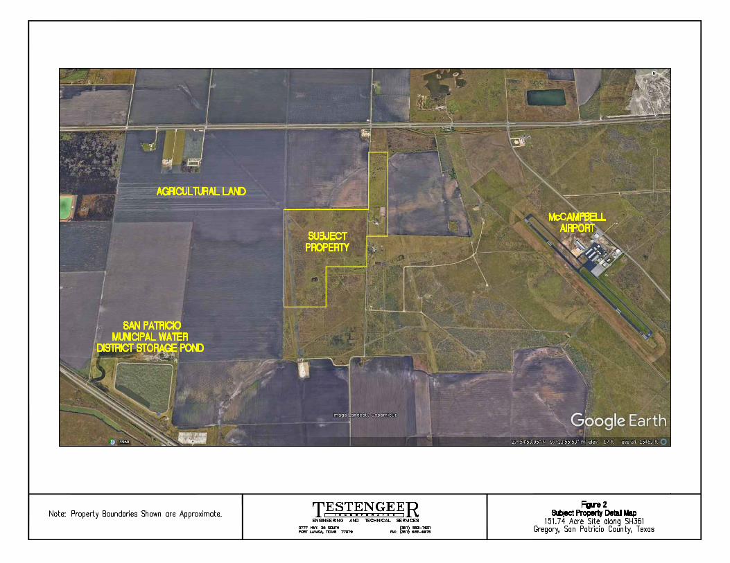
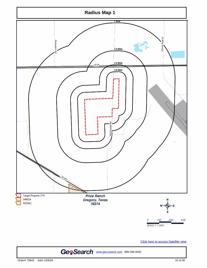
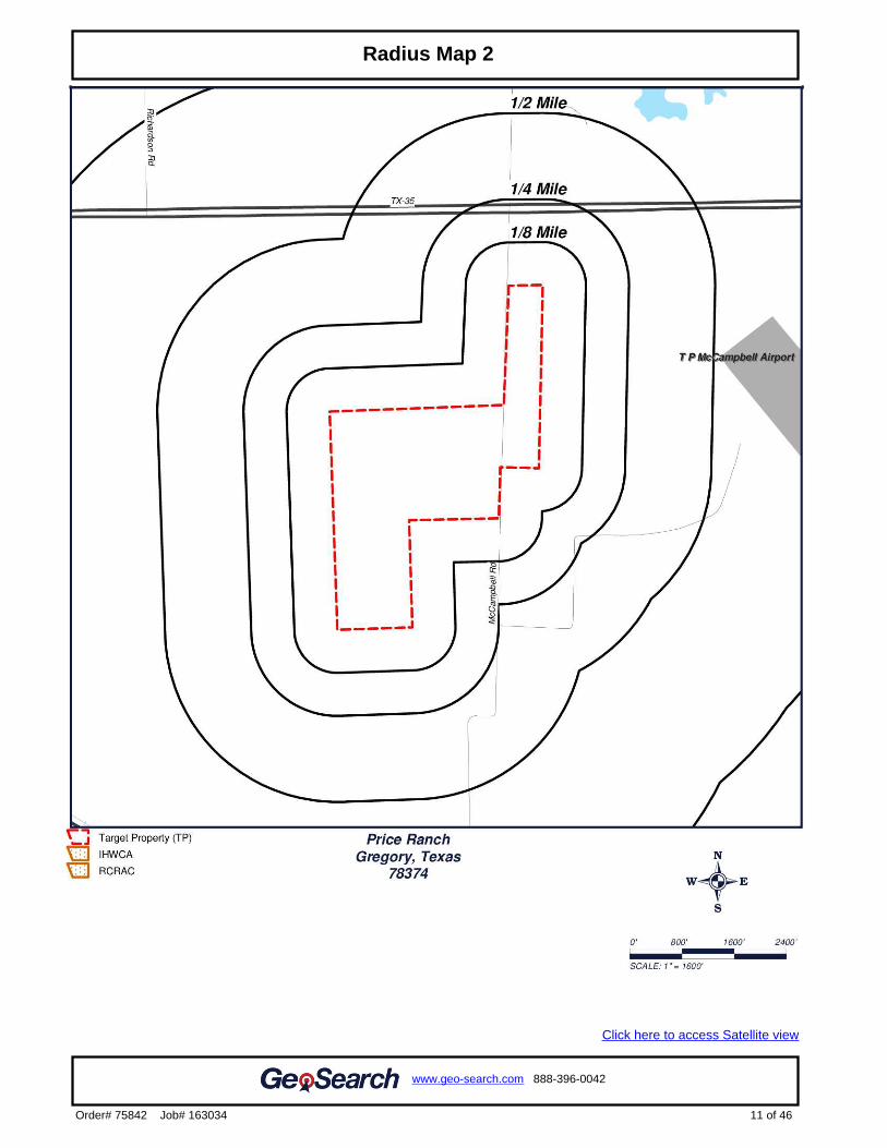
The subject property is located to the north of SH 361 approximately 3.2 miles east of Gregory, Texas. The center of the property lies at approximately 27° 55’ 02.8” north latitude and 97° 14’ 06.1” west longitude. The Subject Property Location Map and Subject Property Detail Map are provided as Figures 1 and 2.
2.2 Legal Description
The Subject property consists of four parcels in San Patricio County with legal descriptions as follows:
Northeast parcel: PT OF ABST 243 W.W. SMITH SUR & ABST 123 J. FISH 33.28 ACRES
Southeast parcel: PT OF ABST 243 W W SMITH 0.476 ACRES
Northwest parcel: AB 145 T T WILLIAMSON SUR 100 ACRES
Southwest parcel is: AB 145 T T WILLIAMSON SUR
2.3 Property and Vicinity Characteristics
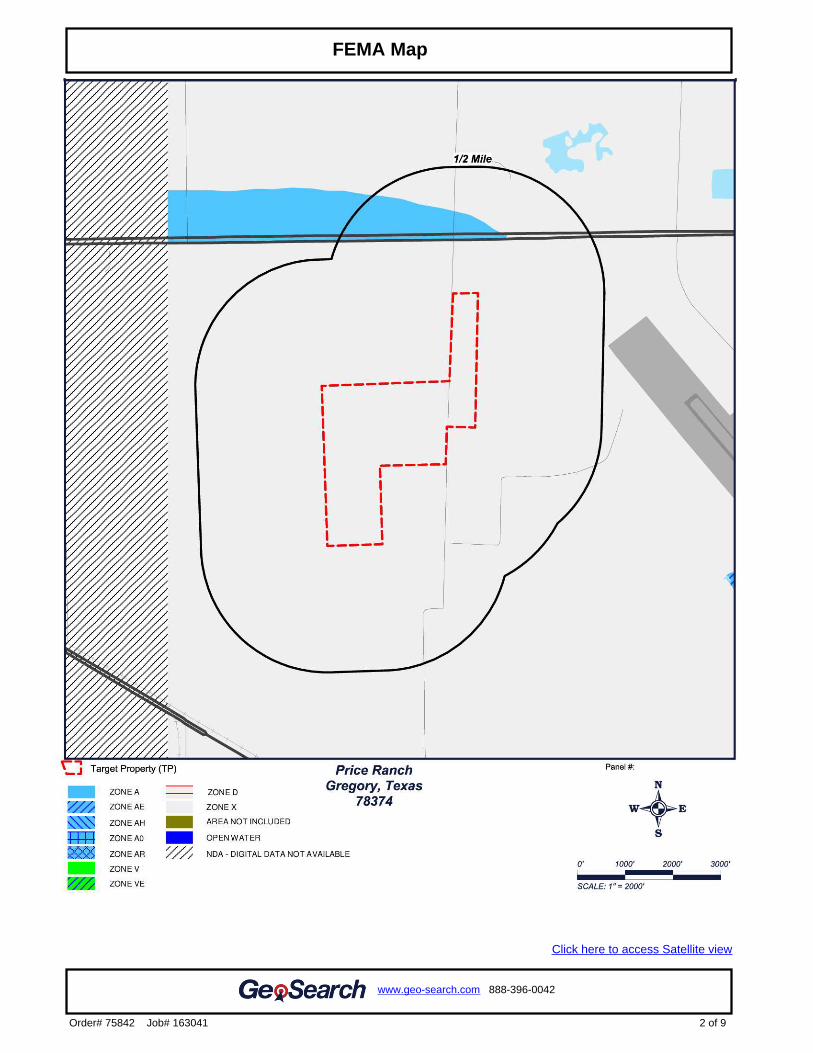
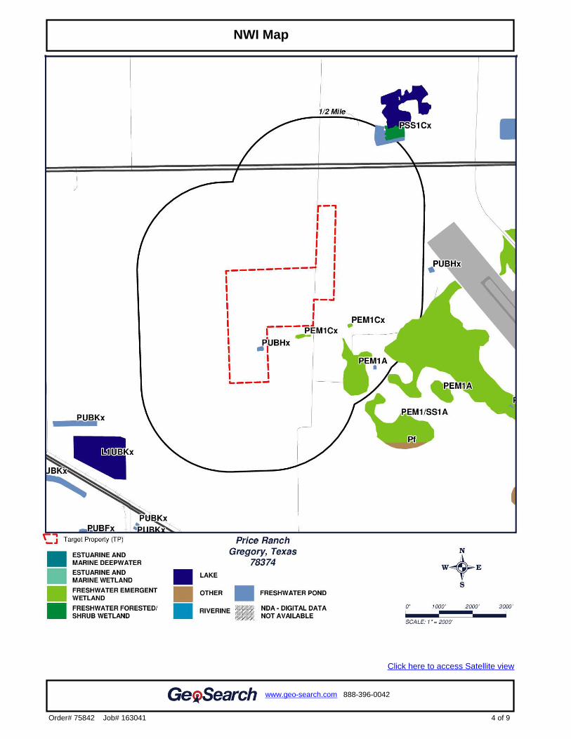
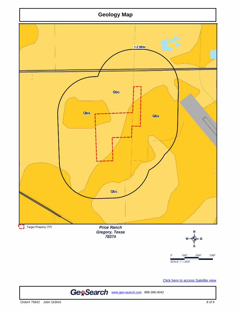
The center of the subject property is located at approximately 16 feet above sea level. Federal Emergency Management Agency (FEMA) flood data was reviewed and it was determined that the subject property is in Zone X (areas of minimal flooding). There is one freshwater pond located on the subject property. Soils of the subject property consist of Orelia fine sandy loam, Orelia sandy clay loam, Papalote fine sandy loam, Raymondville clay loam, and Victoria clay. Orelia fine sandy loam and Papalote fine sandy loam are found in the class A hydrologic group and are well drained. Orelia sandy clay loam and Victoria clay are found in the Class C hydrologic group and have a low infiltration rate with a moderate to high runoff rate. Raymondville clay loam is found in the Class D hydrologic group and is poorly drained and has a high runoff rate. The geologic information for the subject property lists the rock stratigraphic unit under geology symbol Qbc and Qbs, which is Phanerozoic Eon, Cenozoic era, and Quaternary period, and Pleistocene-Late period. The unit name for Qbc is Beaumont Formation, Areas Predominantly Clay. The unit name for Qbs is Beaumont Formation, areas predominately sand. Physical feature information was provided by GeoSearch in the Physical Settings Report which is provided as Exhibit A.
3
2.4 Easements and Right of Ways
Review of aerial and street photography indicates that electric transmission lines, a drainage ditch along County Rd 4343, between the east and west parcels of the subject property. Eleven pipelines are present running through or near the subject property. Three pipelines run through or near the northeastern corner of the northeast parcel, two pipelines run northwest/southeast through the center of the northwest parcel, five pipelines run north/south along the western parcels, and one pipeline runs northwest/southeast through the southwest corner of the southwest parcel of the subject property. 2.5 Title Review
A Chain of Title search was not performed for this property.
2.6 Current Uses of Subject Property
The southeast parcel is currently used as a residential property. The remaining subject property is currently undeveloped agricultural land.
2.7 Past Uses of Subject Property
Based on available information, the subject property appears to have been agricultural land, with some oil and gas exploration occurring on the eastern portion of the property.
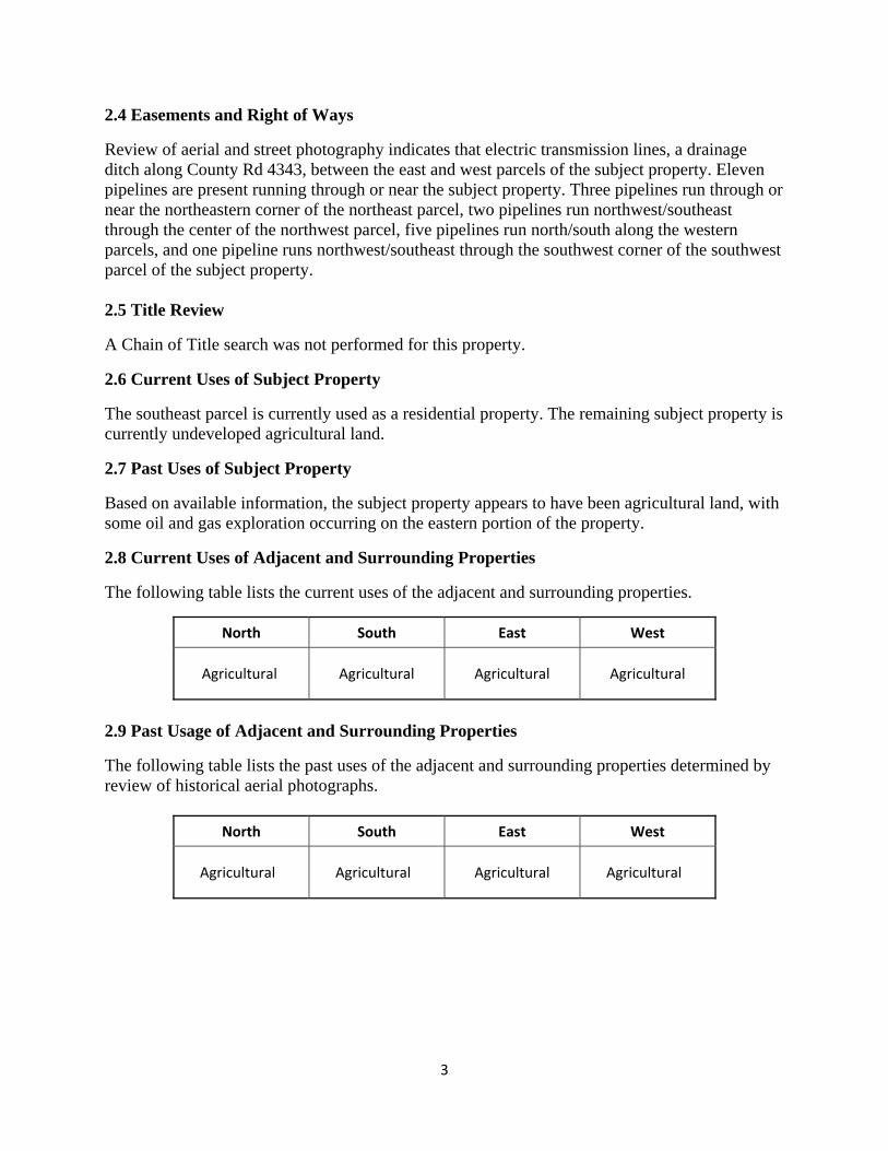
2.8 Current Uses of Adjacent and Surrounding Properties
The following table lists the current uses of the adjacent and surrounding properties.
North South East West
Agricultural Agricultural Agricultural Agricultural
2.9 Past Usage of Adjacent and Surrounding Properties
The following table lists the past uses of the adjacent and surrounding properties determined by review of historical aerial photographs.
North South East West
Agricultural Agricultural Agricultural Agricultural
4
3.0 Record Review
3.1 General
Public and private entities are required to comply with applicable federal and state environmental regulations. The primary regulations, which are pertinent to this assessment, are the Comprehensive Environmental Response, Compensation and Liability Act (CERCLA) and the Resource Conservation and Recovery Act (RCRA). Reasonably obtainable agency records were reviewed in order to determine facilities, which might present a potential to release hazardous substances, or petroleum products, which may affect the subject property. 3.2 GeoSearch
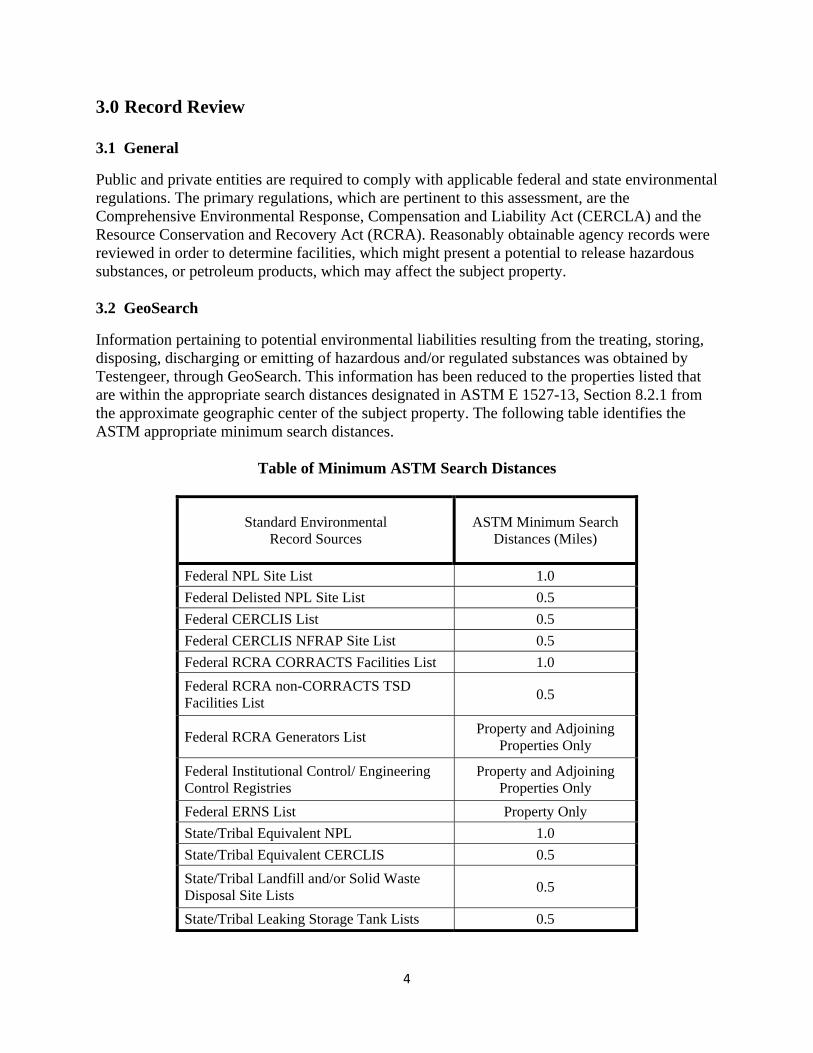
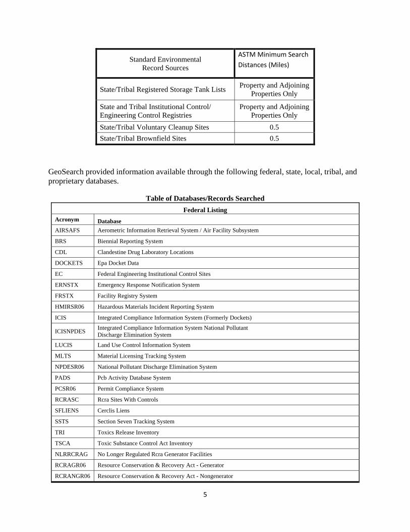
Information pertaining to potential environmental liabilities resulting from the treating, storing, disposing, discharging or emitting of hazardous and/or regulated substances was obtained by Testengeer, through GeoSearch. This information has been reduced to the properties listed that are within the appropriate search distances designated in ASTM E 1527-13, Section 8.2.1 from the approximate geographic center of the subject property. The following table identifies the ASTM appropriate minimum search distances.
Table of Minimum ASTM Search Distances
Standard Environmental Record Sources
ASTM Minimum Search Distances (Miles)
Federal NPL Site List 1.0
Federal Delisted NPL Site List 0.5
Federal CERCLIS List 0.5
Federal CERCLIS NFRAP Site List 0.5
Federal RCRA CORRACTS Facilities List 1.0
Federal RCRA non-CORRACTS TSD Facilities List
0.5
Federal RCRA Generators List Property and Adjoining
Properties Only
Federal Institutional Control/ Engineering Control Registries
Property and Adjoining Properties Only
Federal ERNS List Property Only
State/Tribal Equivalent NPL 1.0
State/Tribal Equivalent CERCLIS 0.5
State/Tribal Landfill and/or Solid Waste Disposal Site Lists
0.5
State/Tribal Leaking Storage Tank Lists 0.5
5
Standard Environmental Record Sources
ASTM Minimum Search
Distances (Miles)
State/Tribal Registered Storage Tank Lists Property and Adjoining
Properties Only
State and Tribal Institutional Control/ Engineering Control Registries
Property and Adjoining Properties Only
State/Tribal Voluntary Cleanup Sites 0.5
State/Tribal Brownfield Sites 0.5
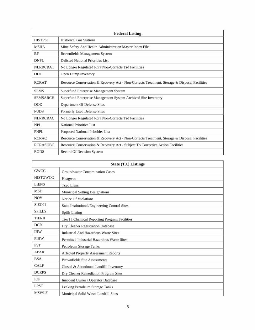
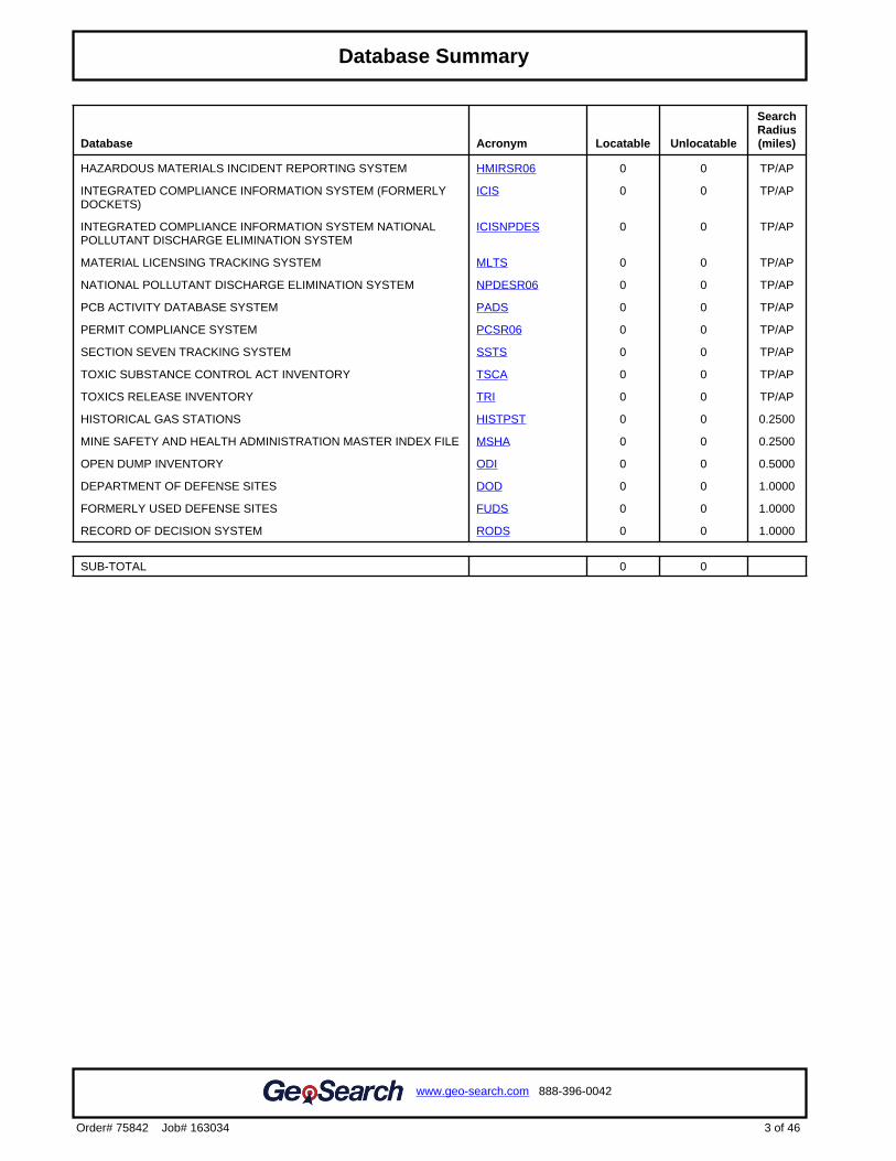
GeoSearch provided information available through the following federal, state, local, tribal, and proprietary databases.
Table of Databases/Records Searched
Federal Listing Acronym Database
AIRSAFS Aerometric Information Retrieval System / Air Facility Subsystem
BRS Biennial Reporting System
CDL Clandestine Drug Laboratory Locations
DOCKETS Epa Docket Data
EC Federal Engineering Institutional Control Sites
ERNSTX Emergency Response Notification System
FRSTX Facility Registry System
HMIRSR06 Hazardous Materials Incident Reporting System
ICIS Integrated Compliance Information System (Formerly Dockets)
ICISNPDES Integrated Compliance Information System National Pollutant Discharge Elimination System
LUCIS Land Use Control Information System
MLTS Material Licensing Tracking System
NPDESR06 National Pollutant Discharge Elimination System
PADS Pcb Activity Database System
PCSR06 Permit Compliance System
RCRASC Rcra Sites With Controls
SFLIENS Cerclis Liens
SSTS Section Seven Tracking System
TRI Toxics Release Inventory
TSCA Toxic Substance Control Act Inventory
NLRRCRAG No Longer Regulated Rcra Generator Facilities
RCRAGR06 Resource Conservation & Recovery Act - Generator
RCRANGR06 Resource Conservation & Recovery Act - Nongenerator
6
Federal Listing
HISTPST Historical Gas Stations
MSHA Mine Safety And Health Administration Master Index File
BF Brownfields Management System
DNPL Delisted National Priorities List
NLRRCRAT No Longer Regulated Rcra Non-Corracts Tsd Facilities
ODI Open Dump Inventory
RCRAT Resource Conservation & Recovery Act - Non-Corracts Treatment, Storage & Disposal Facilities
SEMS Superfund Enterprise Management System
SEMSARCH Superfund Enterprise Management System Archived Site Inventory
DOD Department Of Defense Sites
FUDS Formerly Used Defense Sites
NLRRCRAC No Longer Regulated Rcra Non-Corracts Tsd Facilities
NPL National Priorities List
PNPL Proposed National Priorities List
RCRAC Resource Conservation & Recovery Act - Non-Corracts Treatment, Storage & Disposal Facilities
RCRASUBC Resource Conservation & Recovery Act - Subject To Corrective Action Facilities
RODS Record Of Decision System
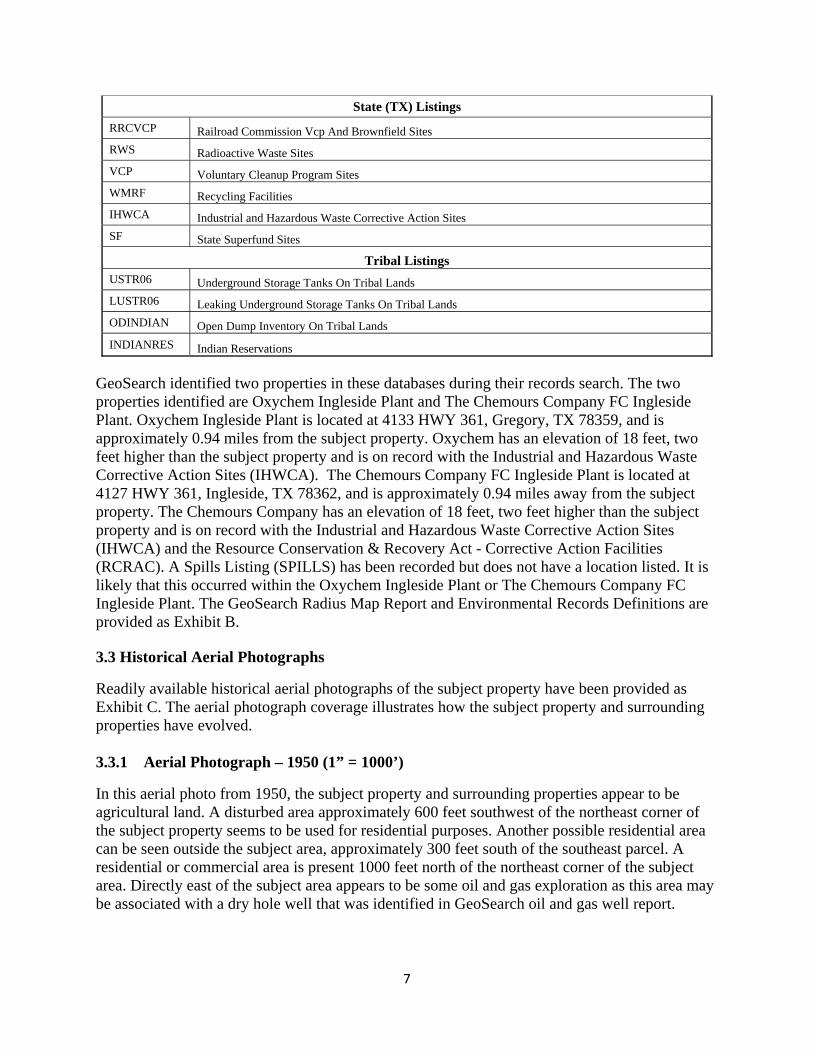
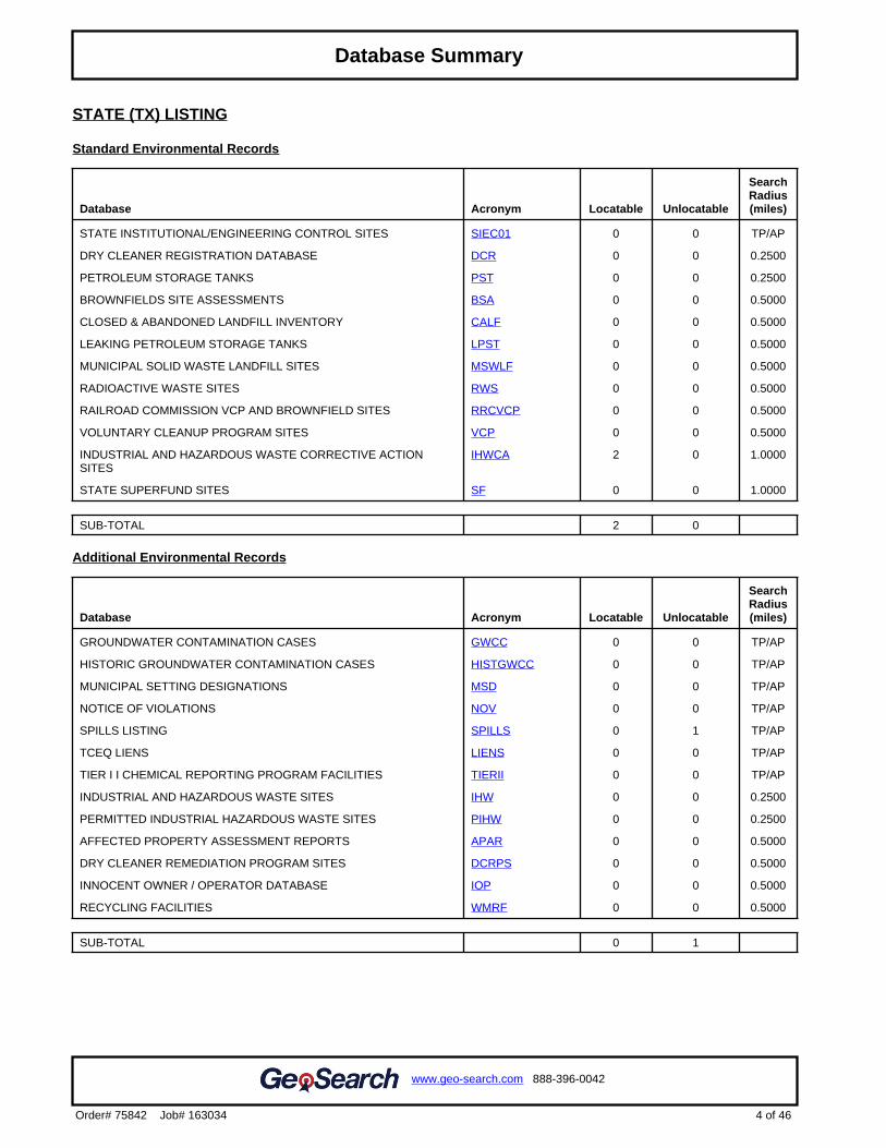
State (TX) Listings
GWCC Groundwater Contamination Cases
HISTGWCC Histgwcc
LIENS Tceq Liens
MSD Municipal Setting Designations
NOV Notice Of Violations
SIEC01 State Institutional/Engineering Control Sites
SPILLS Spills Listing
TIERII Tier I I Chemical Reporting Program Facilities
DCR Dry Cleaner Registration Database
IHW Industrial And Hazardous Waste Sites
PIHW Permitted Industrial Hazardous Waste Sites
PST Petroleum Storage Tanks
APAR Affected Property Assessment Reports
BSA Brownfields Site Assessments
CALF Closed & Abandoned Landfill Inventory
DCRPS Dry Cleaner Remediation Program Sites
IOP Innocent Owner / Operator Database
LPST Leaking Petroleum Storage Tanks
MSWLF Municipal Solid Waste Landfill Sites
7
State (TX) Listings
RRCVCP Railroad Commission Vcp And Brownfield Sites
RWS Radioactive Waste Sites
VCP Voluntary Cleanup Program Sites
WMRF Recycling Facilities
IHWCA Industrial and Hazardous Waste Corrective Action Sites
SF State Superfund Sites
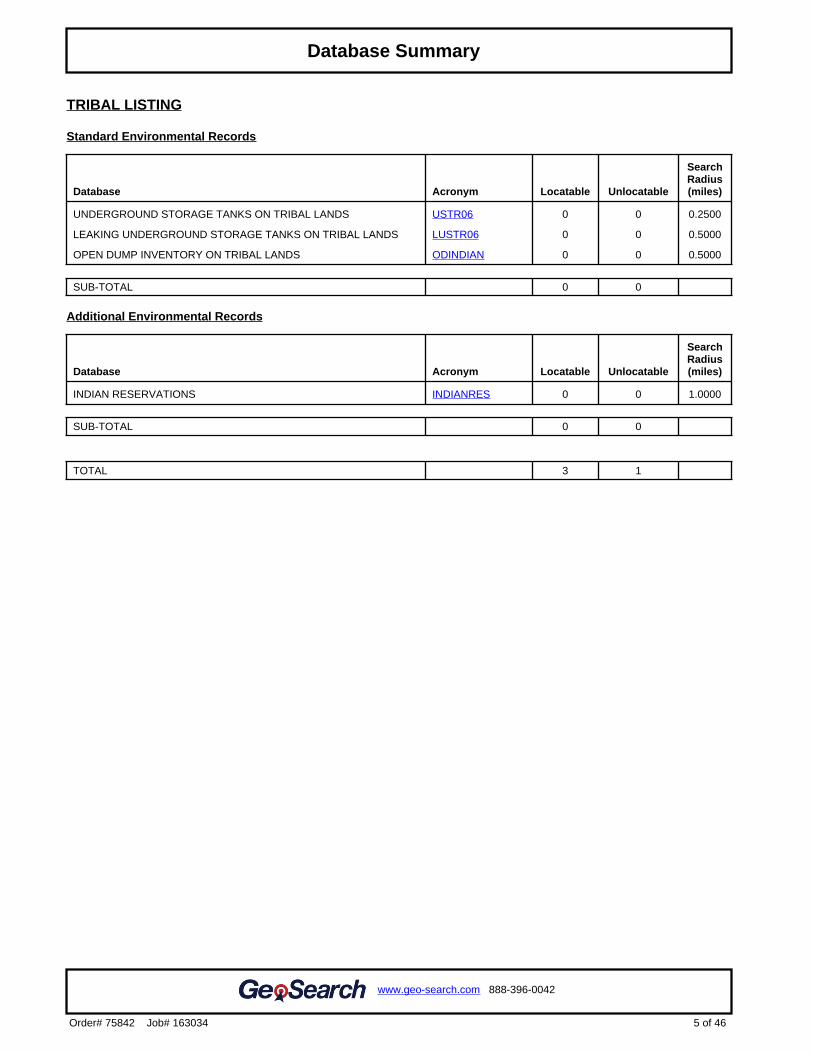
Tribal Listings USTR06 Underground Storage Tanks On Tribal Lands
LUSTR06 Leaking Underground Storage Tanks On Tribal Lands
ODINDIAN Open Dump Inventory On Tribal Lands
INDIANRES Indian Reservations
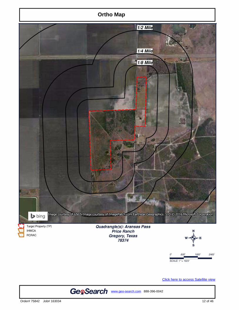
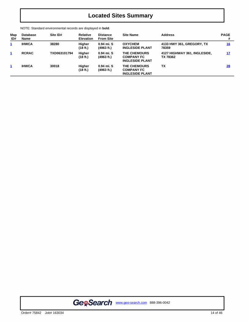
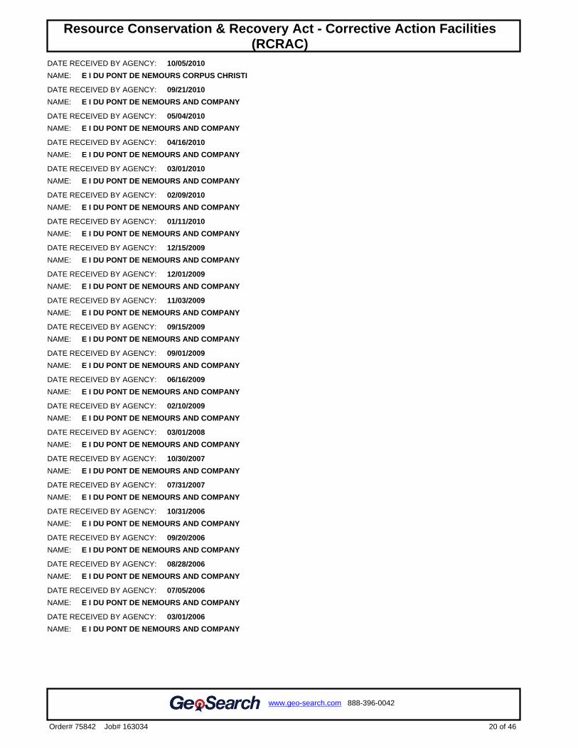
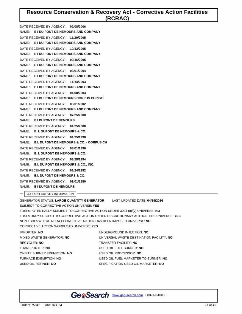
GeoSearch identified two properties in these databases during their records search. The two properties identified are Oxychem Ingleside Plant and The Chemours Company FC Ingleside Plant. Oxychem Ingleside Plant is located at 4133 HWY 361, Gregory, TX 78359, and is approximately 0.94 miles from the subject property. Oxychem has an elevation of 18 feet, two feet higher than the subject property and is on record with the Industrial and Hazardous Waste Corrective Action Sites (IHWCA). The Chemours Company FC Ingleside Plant is located at 4127 HWY 361, Ingleside, TX 78362, and is approximately 0.94 miles away from the subject property. The Chemours Company has an elevation of 18 feet, two feet higher than the subject property and is on record with the Industrial and Hazardous Waste Corrective Action Sites (IHWCA) and the Resource Conservation & Recovery Act - Corrective Action Facilities (RCRAC). A Spills Listing (SPILLS) has been recorded but does not have a location listed. It is likely that this occurred within the Oxychem Ingleside Plant or The Chemours Company FC Ingleside Plant. The GeoSearch Radius Map Report and Environmental Records Definitions are provided as Exhibit B. 3.3 Historical Aerial Photographs
Readily available historical aerial photographs of the subject property have been provided as Exhibit C. The aerial photograph coverage illustrates how the subject property and surrounding properties have evolved. 3.3.1 Aerial Photograph – 1950 (1” = 1000’)
In this aerial photo from 1950, the subject property and surrounding properties appear to be agricultural land. A disturbed area approximately 600 feet southwest of the northeast corner of the subject property seems to be used for residential purposes. Another possible residential area can be seen outside the subject area, approximately 300 feet south of the southeast parcel. A residential or commercial area is present 1000 feet north of the northeast corner of the subject area. Directly east of the subject area appears to be some oil and gas exploration as this area may be associated with a dry hole well that was identified in GeoSearch oil and gas well report.
8
3.3.2 Aerial Photograph – 1961 (1” = 1000’)
In this aerial photo from 1961, additional disturbed areas potentially associated with oil and gas exploration can be seen east of the subject property. To the East of the southeast parcel, a path and well pad can be seen. To the east of the southwest parcel, more paths and four well pads can be seen. These locations coincide with GeoSearch records for three plugged oil wells, an oil well, and a plugged oil/gas well. A freshwater wetland and a livestock pond appear approximately 300 feet outside the southeast corner of the northwest parcel. Most surrounding properties are still being used for agriculture and all residential/commercial areas are still present.
3.3.3 Aerial Photograph – 1972 (1” = 1000’)
In this aerial photo from 1972, the paths and well pads are still visible with more oil and gas exploration extending further southeast from the subject property. The bodies of water and residential/commercial areas are less visible. Most surrounding properties are still being used for agricultural purposes.
3.3.4 Aerial Photograph – 1984 (1” = 1000’)
In this aerial photo from 1984, the northeast parcel of the subject property appears to have an area of disturbed soil when compared to surrounding land. This disturbance may be associated with a dry hole well that was identified in GeoSearch records as being near this area. A freshwater pond has appeared in the southwest parcel of the subject property. Surrounding properties appear similar to the previous photo.
3.3.5 Aerial Photograph – 1996 (1” = 1000’)
In this aerial photo from 1996, a house has been built in the southeast parcel of the subject property with a dirt area likely used for livestock in the northeast corner of this parcel. Most oil and gas exploration efforts to the east of the property have ended. A fresh water wetland can be seen approximately 1000 feet east from the south east corner of the northwest parcel. Most Surrounding properties are still being used for agricultural purposes.
3.3.6 Aerial Photograph – 2004 (1” = 1000’)
In this aerial photo from 2004, the subject property appears to be similar to the previous photo. A new well pad can be seen approximately 1500 feet south of the southwest parcel.
3.3.7 Aerial Photograph – 2014 (1” = 1000’)
In this aerial photo from 2014, the subject property appears to be similar to the previous photo. The freshwater pond in the southwest parcel and the bodies of water outside the subject property has dried up. Most surrounding properties are still being used for agricultural purposes.
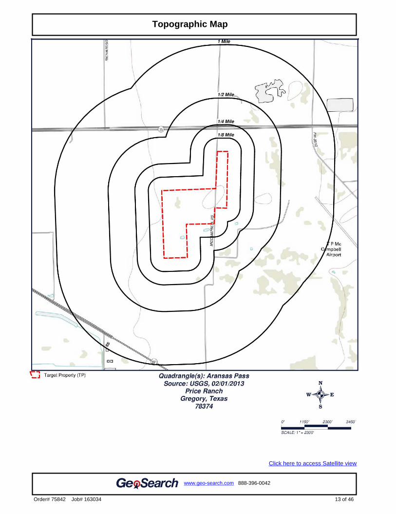
3.4 Historical Topographic Maps
Historic topographic maps provide information on the topography of the subject property and surrounding properties, and may contain information on oil and gas exploration and waste disposal. No signs of waste disposal on the subject property or surrounding properties are shown on the maps. The maps from 1954, 1971, and 1975 show the pipelines that run through the
9
subject property. The 1923 and 1954 map shows small structures along the eastside of McCampbell road. The historic topographic maps are provided as Exhibit D.
3.5 City Directories
City Directory services were requested from GeoSearch for this report and the City Directory Report is provided as Exhibit E. Listings for sites and adjacent properties of the subject property on CR 93 and HWY 35 include: Jim Price JR, Susan Price, Rick Hinojosa, Linda L Basiorka, Debbie Marie Richards, Ronald Benton, Mekk Inc., and The Playho. 3.6 Fire Insurance Maps
Historical fire insurance maps were requested from GeoSearch to evaluate the past uses and relevant characteristics of the site and surrounding properties. The subject property is shown as an unmapped property, with no fire insurance maps available for review. The Fire Insurance Map Report is provided as Exhibit F.
3.7 Environmental Liens
The Environmental Lien search was performed by GeoSearch; the results are provided as Exhibit G. According to the Environmental Lien search, no environmental liens or activity and usage limitations were found. 3.8 Oil and Gas Exploration
GeoSearch records reported that there is one oil and/or gas related well on the subject property and 22 additional oil and/or gas related wells within a one-half mile radius of the subject property. In addition, GeoSearch reported one water well located within one half mile radius of the subject property. This well is located in the Texas Water Development Board Groundwater Database. The well is 0.48 miles north of the subject property and owned by J.S McCampbell. GeoSearch Oil and Gas Report can be found as Exhibit H and GeoSearch’s Water Well Report can be found as Exhibit I.
A search of Railroad Commission of Texas’s (RRC) records also reported on oil and/or gas well on the subject property and 22 oil and/or gas wells within a one-half mile radius of the subject property. There is a total of ten pipelines running through or connecting with the property boundary. There is one ethylene pipeline, two natural gas pipelines, one Y grades product pipeline and one brine pipeline running along the western property boundary. Crossing through the southwest corner of the property boundary is one crude oil pipeline. One natural gas line and one nitrogen line pass through the northwestern parcel directionally northwest to southeast. Two crude oil pipelines and one ethane gas pipeline run northwest/southeast through the northeastern corner of the property boundary. A Map of RRC’s oil/gas wells, pipeline map, and pipeline information has been provided as exhibit J.
10
4.0 Property Reconnaissance
4.1 General
A property reconnaissance visit of the subject property was conducted for this Limited Phase I ESA. 4.2 Observations
The majority of the subject property is undeveloped and has been used as agricultural land. The southeast parcel is used as residential property, containing a 3,800 square foot house. The northeast parcel is used as a rental property containing rental trailers. Some oil and gas exploration has occurred along the eastern portion of the subject property. 4.3 Interior and Exterior of Home
The southeast parcel contains a 3,800 square foot house with 4 bedrooms and 5 bathrooms. Housekeeping is noted to be fair throughout the building and property. A 13 ½ x 33 ½ foot swimming pool is located on the southeast side of the house.
4.4 Pits, Ponds, and Lagoons
Based on recent aerial photography, one freshwater pond appears to be located on the southwest parcel of the subject property. 4.5 Stained Soils
Based on recent aerial photography and property reconnaissance, no visible stained soils appear to be located on the majority of the subject property.
4.6 Stressed Vegetation
Based on recent aerial photography and property reconnaissance, no signs of stressed vegetation appear to be located on the majority of the subject property.
4.7 Possible Presence of Polychlorinated Biphenyls (PCBs)
Based on recent aerial and street photography, property reconnaissance, and interview with current owner, there are no signs of PCBs on the subject property. 4.8 Solid Waste Disposal
Based on recent aerial photography and property reconnaissance, no signs of solid waste disposal were observed in the subject property. 4.9 Identification of Contaminant Migration Paths
The topography of the subject property is flat. The approximate elevation of the subject property is 16 feet above sea level. Majority of the surface of the subject property is unpaved. The most

11
likely migration path for contaminants to the subject property would be via airborne path from nearby industrial properties or soil infiltrations originating from neighboring industrial properties or buried pipelines.
4.10 Wastewater
Based on recent aerial photography and property reconnaissance, there is a septic tank and associated drain field piping which serves the residence located on the southeast parcel. 4.11 Property Utilities
Resident is served by overhead electric, city water, and a private septic system. Subject property does not contain fiber optic lines.
4.12 Other Issues
Subject property is located near McCampbell airport, approximately 0.52 miles east of the nearest portion of subject property. Certain building height restrictions or regulations may be required to comply with FAA regulations.
5.0 Interviews
Mr. James Price was interviewed on November 8th, 2016. No new information was discovered during this interview. Throughout Mr. Price’s ownership of this property, no leaks or spills have occurred that could potentially contaminate the soil. Mr. Price acquired the first parcel, where the residence is built, in 1991 and acquired the remaining parcels in 2005, 2012, and 2013.
6.0 Conclusion and Recommendations
Testengeer, Inc. conducted a Limited Phase I Environmental Site Assessment (ESA) on a 183.756-acre site along Texas State Highway (SH) 35 near Gregory, San Patricio County, Texas 78374. The Limited ESA was performed in general conformance with the requirements of the American Society for Testing Materials (ASTM) Standard Practice for Environmental Site Assessments: Phase I Environmental Site Assessment Process, Designation E1527–13. Information pertaining to potential environmental liabilities resulting from the treating, storing, disposing, discharging, or emitting of hazardous and/or regulated substances was obtained by Testengeer through GeoSearch. GeoSearch’s search of available government records identified two sites within one mile of the subject property. The two properties identified were Oxychem Ingleside Plant and The Chemours Company FC Ingleside Plant. Oxychem Ingleside Plant is located at 4133 HWY 361, Gregory, TX 78359, and is approximately 0.94 miles from the subject property. Oxychem has an elevation of 18 feet, two feet higher than the subject property and is on record with the Industrial and Hazardous Waste Corrective Action Sites (IHWCA). The Chemours Company FC Ingleside Plant is located at 4127 HWY 361, Ingleside, TX 78362, and is approximately 0.94 miles away from the subject property. The Chemours Company has an elevation of 18 feet, two feet higher than the subject property and is on record with the Industrial and Hazardous Waste Corrective Action Sites (IHWCA) and the Resource Conservation & Recovery Act - Corrective Action Facilities (RCRAC). A Spills Listing (SPILLS) has been
12
recorded but does not have a location listed, it is likely that this occurred within the Ocychem Ingleside Plant or The Chemours Company FC Ingleside Plant. A search of Railroad Commission of Texas’s (RRC) records also reported an oil and/or gas well on the subject property and 22 oil and/or gas wells within a one-half mile radius of the subject property. Ten underground pipelines are present within the property boundary. There is one propane pipeline, two natural gas pipelines, and one ethylene pipeline running along the western property boundary. Crossing through the southwest corner of the property boundary is one crude oil pipeline. One natural gas line and one nitrogen line pass through the northwestern parcel directionally northwest to southeast. Two crude oil pipelines and one ethane gas pipeline run northwest/southeast through the northeastern corner of the property boundary. GeoSearch records reported that there is one oil and/or gas related well on the subject property and 22 additional oil and/or gas related wells within a one-half mile radius of the subject property. In addition, GeoSearch reported one water well located within one half mile radius of the subject property. This well is located in the Texas Water Development Board Groundwater Database. The well is 0.48 miles north of the subject property and owned by J.S McCampbell.
Based on recent aerial photography, there does not appear to be any stained soil, stressed vegetation, or waste disposal/collection pits, subject property. One freshwater pond appears to be located on the southwest parcel of the subject property. Our review of site information revealed the following potential environmental liabilities:
1. Historic oil and gas exploration on the eastern portion of the subject property. 2. Presence of ten oil/gas related pipelines running through, or connecting with the property
boundary. Recommendations: Due to the potential environmental liabilities described above, a Phase II Environmental Site Assessment, including soil vapor screening and soil and groundwater sampling, is recommended.

FIGURES
FIGURE 1
Subject Property Location Map

FIGURE 2
Subject Property Detail Map

EXHIBITS
EXHIBIT A
Physical Settings Report
GeoPlus Physical Setting Maps
Satellite view
Target Property:
Price Ranch
Gregory, San Patricio County, Texas 78374
Prepared For:
Testengeer Inc
Order #: 75842
Job #: 163041
Project #: 20109838
Date: 10/05/2016
0 of 9
www.geo-search.com 888-396-0042
Order# 75842 Job# 163041
Target Property Summary 1
FEMA Map 2
FEMA Report 3
NWI Map 4
NWI Report 5
SOIL Map 6
SOIL Report 7
GEOLOGY Map 8
GEOLOGY Report 9
www.geo-search.com 888-396-0042
Order# 75842 Job# 163041
Target Property SummaryFEMA ReportNWI ReportSOIL ReportGEOLOGY ReportTable of Contents

The information provided in this report was obtained from a variety of public sources. GeoSearch cannot ensure and makes nowarranty or representation as to the accuracy, reliability, quality, errors occurring from data conversion or the customer's interpretation ofthis report. This report was made by GeoSearch for exclusive use by its clients only. Therefore, this report may not contain sufficientinformation for other purposes or parties. GeoSearch and its partners, employees, officers And independent contractors cannot be heldliable For actual, incidental, consequential, special or exemplary damages suffered by a customer resulting directly or indirectly from anyinformation provided by GeoSearch.
www.geo-search.com 888-396-0042
Order# 75842 Job# 163041
Target Property SummaryFEMA ReportNWI ReportSOIL ReportGEOLOGY ReportTable of ContentsDisclaimer

Target Property InformationPrice RanchGregory, Texas 78374
CoordinatesArea
USGS QuadrangleAransas Pass, TX
Geographic Coverage InformationCounty/Parish: San Patricio (TX) ZipCode(s): Aransas Pass TX: 78336Portland TX: 78374
Radon* Target property is located in Radon Zone 3.Zone 3 areas have a predicted average indoor radon screening level less than 2 pCi/L (picocuries per liter).
1 of 9
www.geo-search.com 888-396-0042
Order# 75842 Job# 163041
Target Property Summary
.2
Click here to access Satellite view
2 of 9
www.geo-search.com 888-396-0042
Order# 75842 Job# 163041
Target Property SummaryFEMA Map
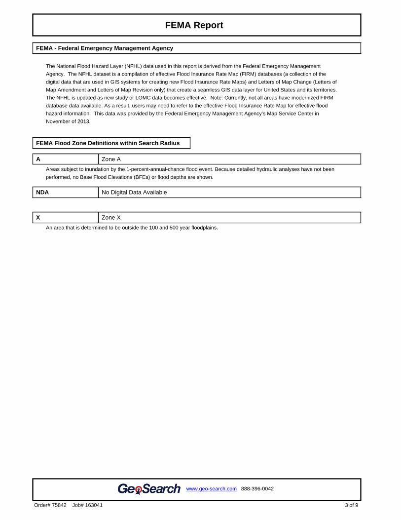
FEMA - Federal Emergency Management Agency
The National Flood Hazard Layer (NFHL) data used in this report is derived from the Federal Emergency Management
Agency. The NFHL dataset is a compilation of effective Flood Insurance Rate Map (FIRM) databases (a collection of the
digital data that are used in GIS systems for creating new Flood Insurance Rate Maps) and Letters of Map Change (Letters of
Map Amendment and Letters of Map Revision only) that create a seamless GIS data layer for United States and its territories.
The NFHL is updated as new study or LOMC data becomes effective. Note: Currently, not all areas have modernized FIRM
database data available. As a result, users may need to refer to the effective Flood Insurance Rate Map for effective flood
hazard information. This data was provided by the Federal Emergency Management Agency’s Map Service Center in
November of 2013.
FEMA Flood Zone Definitions within Search Radius
A Zone A
Areas subject to inundation by the 1-percent-annual-chance flood event. Because detailed hydraulic analyses have not been
performed, no Base Flood Elevations (BFEs) or flood depths are shown.
NDA No Digital Data Available
X Zone X
An area that is determined to be outside the 100 and 500 year floodplains.
3 of 9
www.geo-search.com 888-396-0042
Order# 75842 Job# 163041
Target Property SummaryFEMA Report
.4
Click here to access Satellite view
4 of 9
www.geo-search.com 888-396-0042
Order# 75842 Job# 163041
Target Property SummaryFEMA ReportNWI Map
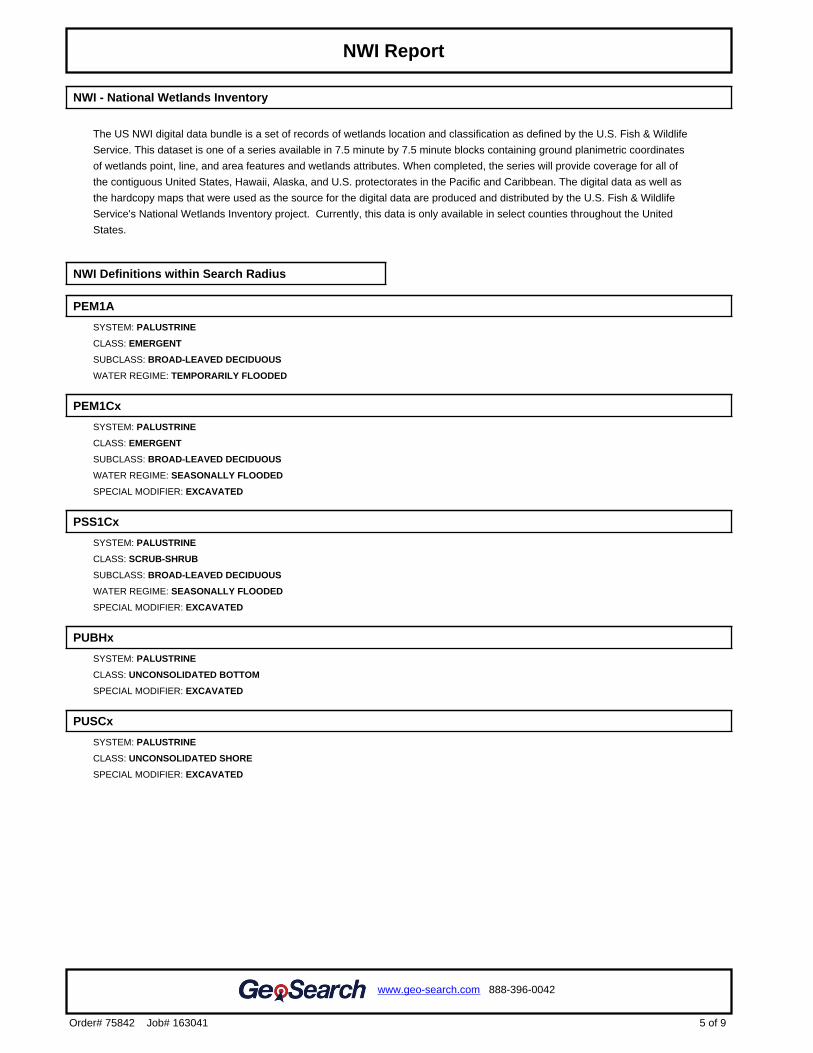
NWI - National Wetlands Inventory
The US NWI digital data bundle is a set of records of wetlands location and classification as defined by the U.S. Fish & Wildlife
Service. This dataset is one of a series available in 7.5 minute by 7.5 minute blocks containing ground planimetric coordinates
of wetlands point, line, and area features and wetlands attributes. When completed, the series will provide coverage for all of
the contiguous United States, Hawaii, Alaska, and U.S. protectorates in the Pacific and Caribbean. The digital data as well as
the hardcopy maps that were used as the source for the digital data are produced and distributed by the U.S. Fish & Wildlife
Service's National Wetlands Inventory project. Currently, this data is only available in select counties throughout the United
States.
NWI Definitions within Search Radius
PEM1A
SYSTEM: PALUSTRINE
CLASS: EMERGENT
SUBCLASS: BROAD-LEAVED DECIDUOUS
WATER REGIME: TEMPORARILY FLOODED
PEM1Cx
SYSTEM: PALUSTRINE
CLASS: EMERGENT
SUBCLASS: BROAD-LEAVED DECIDUOUS
WATER REGIME: SEASONALLY FLOODED
SPECIAL MODIFIER: EXCAVATED
PSS1Cx
SYSTEM: PALUSTRINE
CLASS: SCRUB-SHRUB
SUBCLASS: BROAD-LEAVED DECIDUOUS
WATER REGIME: SEASONALLY FLOODED
SPECIAL MODIFIER: EXCAVATED
PUBHx
SYSTEM: PALUSTRINE
CLASS: UNCONSOLIDATED BOTTOM
SPECIAL MODIFIER: EXCAVATED
PUSCx
SYSTEM: PALUSTRINE
CLASS: UNCONSOLIDATED SHORE
SPECIAL MODIFIER: EXCAVATED
5 of 9
www.geo-search.com 888-396-0042
Order# 75842 Job# 163041
Target Property SummaryFEMA ReportNWI Report

.6
Click here to access Satellite view
6 of 9
www.geo-search.com 888-396-0042
Order# 75842 Job# 163041
Target Property SummaryFEMA ReportNWI ReportSoil Map
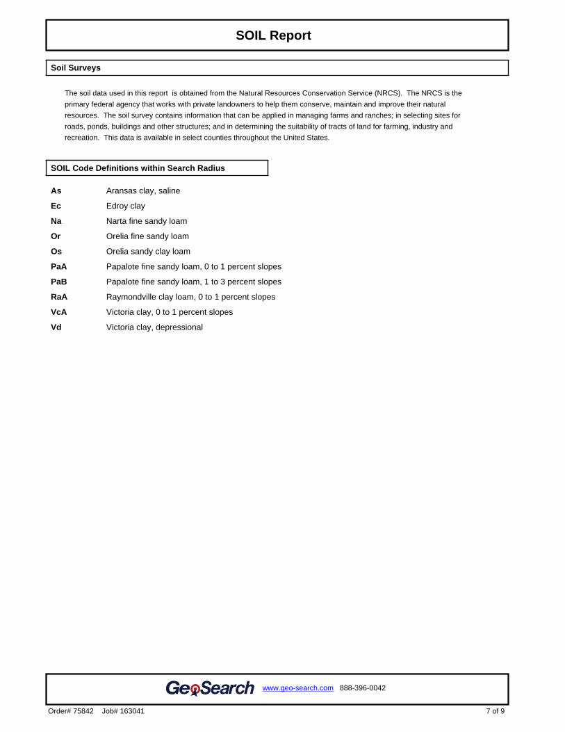
Soil Surveys
The soil data used in this report is obtained from the Natural Resources Conservation Service (NRCS). The NRCS is the
primary federal agency that works with private landowners to help them conserve, maintain and improve their natural
resources. The soil survey contains information that can be applied in managing farms and ranches; in selecting sites for
roads, ponds, buildings and other structures; and in determining the suitability of tracts of land for farming, industry and
recreation. This data is available in select counties throughout the United States.
SOIL Code Definitions within Search Radius
As Aransas clay, saline
Ec Edroy clay
Na Narta fine sandy loam
Or Orelia fine sandy loam
Os Orelia sandy clay loam
PaA Papalote fine sandy loam, 0 to 1 percent slopes
PaB Papalote fine sandy loam, 1 to 3 percent slopes
RaA Raymondville clay loam, 0 to 1 percent slopes
VcA Victoria clay, 0 to 1 percent slopes
Vd Victoria clay, depressional
7 of 9
www.geo-search.com 888-396-0042
Order# 75842 Job# 163041
Target Property SummaryFEMA ReportNWI ReportSOIL Report
.8
Click here to access Satellite view
8 of 9
www.geo-search.com 888-396-0042
Order# 75842 Job# 163041
Target Property SummaryFEMA ReportNWI ReportSOIL ReportGeology Map
US GEOLOGY
THE GEOLOGY DATA USED IN THIS REPORT ORIGINATES FROM THE USGS. THE FIRST STAGE IN DEVELOPING
STATE DATABASES FOR THE CONTERMINOUS UNITED STATES WAS TO ACQUIRE DIGITAL VERSIONS OF ALL
EXISTING STATE GEOLOGIC MAPS. ALTHOUGH A SIGNIFICANT NUMBER OF DIGITAL STATE MAPS ALREADY
EXISTED, A NUMBER OF STATES LACKED THEM. FOR THESE STATES NEW DIGITAL COMPILATIONS WERE
PREPARED IN COOPERATION WITH STATE GEOLOGIC SURVEYS OR BY THE NSA (NATIONAL SURVEYS AND
ANALYSIS) PROJECT. THESE NEW DIGITAL STATE GEOLOGIC MAPS AND DATABASES WERE CREATED BY
DIGITIZING ALREADY EXISTING PRINTED MAPS, OR, IN A FEW CASES, BY MERGING EXISTING LARGER SCALE
DIGITAL MAPS.
GEOLOGY Definitions within Search Radius
GEOLOGY SYMBOL: Qbc
UNIT NAME: Beaumont Formation, areas predominantly clay
UNIT AGE: Phanerozoic | Cenozoic | Quaternary | Pleistocene-Late
UNIT DESCRIPTION:
Beaumont Formation, areas predominantly clay
ADDITIONAL UNIT INFORMATION:
On McAllen-Brownsville Sheet (1976) dominantly clay and mud of low permeability. (from Moore and Wermund, 1993a,
1993b): Light- to dark-gray and bluish- to greenish-gray clay and silt, intermixed and interbedded; contains beds and
lenses of fine sand, de
ROCKTYPE/S: clay or mud; silt;
GEOLOGY SYMBOL: Qbs
UNIT NAME: Beaumont Formation, areas predominantly sand
UNIT AGE: Phanerozoic | Cenozoic | Quaternary | Pleistocene-Late
UNIT DESCRIPTION:
Beaumont Formation, areas predominantly sand
ADDITIONAL UNIT INFORMATION:
(from Moore and Wermund, 1993a, 1993b) Yellowish- to brownish-gray, locally reddish orange, v. fine to fine quartz sand,
silt, and minor fine gravel, intermixed and interbedded. Includes stream channel, point-bar, cravasse-splay, and natural
levee ridge
ROCKTYPE/S: sand; silt; clay or mud; gravel
9 of 9
www.geo-search.com 888-396-0042
Order# 75842 Job# 163041
Target Property SummaryFEMA ReportNWI ReportSOIL ReportGEOLOGY Report
EXHIBIT B
Radius Map Report
Radius Report
Satellite view
Target Property:
Price Ranch
Gregory, San Patricio County, Texas 78374
Prepared For:
Testengeer Inc
Order #: 75842
Job #: 163034
Project #: 20109838
Date: 10/05/2016
0 of 46
www.geo-search.com 888-396-0042
Order# 75842 Job# 163034
Target Property Summary 1
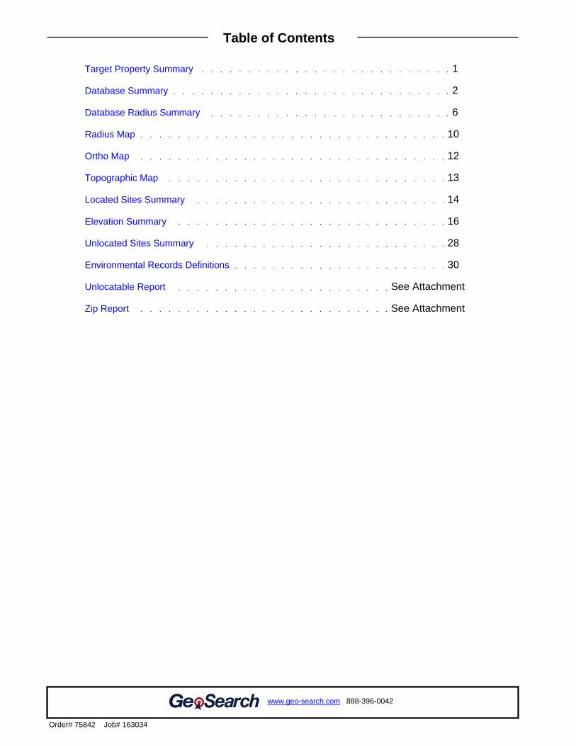
Database Summary 2
Database Radius Summary 6
Radius Map 10
Ortho Map 12
Topographic Map 13
Located Sites Summary 14
Elevation Summary 16
Unlocated Sites Summary 28
Environmental Records Definitions 30
Unlocatable Report See Attachment
Zip Report See Attachment
www.geo-search.com 888-396-0042
Order# 75842 Job# 163034
Target Property SummaryDatabase SummaryDatabase Radius SummaryLocated Sites SummaryElevation SummaryIndustrial and Hazardous Waste Corrective Action Sites (IHWCA)Resource Conservation & Recovery Act - Corrective Action Facilities(RCRAC)Industrial and Hazardous Waste Corrective Action Sites (IHWCA)Unlocated Sites SummaryEnvironmental Records Definitions - FEDERALEnvironmental Records Definitions - STATE (TX)Environmental Records Definitions - TRIBALTable of Contents
This report was designed by GeoSearch to meet or exceed the records search requirements of the All Appropriate Inquiries Rule (40 CFR§312.26) and the current version of the ASTM International E1527, Standard Practice for Environmental Site Assessments: Phase IEnvironmental Site Assessment Process or, if applicable, the custom requirements requested by the entity that ordered this report. Therecords and databases of records used to compile this report were collected from various federal,state and local governmental entities. It isthe goal of GeoSearch to meet or exceed the 40 CFR §312.26 and E1527 requirements for updating records by using the best availabletechnology. GeoSearch contacts the appropriate governmental entities on a recurring basis. Depending on the frequency with which arecord source or database of records is updated by the governmental entity, the data used to prepare this report may be updated monthly,quarterly, semi-annually, or annually.
The information provided in this report was obtained from a variety of public sources. GeoSearch cannot ensure and makes nowarranty or representation as to the accuracy, reliability, quality, errors occurring from data conversion or the customer's interpretation ofthis report. This report was made by GeoSearch for exclusive use by its clients only. Therefore, this report may not contain sufficientinformation for other purposes or parties. GeoSearch and its partners, employees, officers And independent contractors cannot be heldliable For actual, incidental, consequential, special or exemplary damages suffered by a customer resulting directly or indirectly from anyinformation provided by GeoSearch.
www.geo-search.com 888-396-0042
Order# 75842 Job# 163034
Target Property SummaryDatabase SummaryDatabase Radius SummaryLocated Sites SummaryElevation SummaryIndustrial and Hazardous Waste Corrective Action Sites (IHWCA)Resource Conservation & Recovery Act - Corrective Action Facilities(RCRAC)Industrial and Hazardous Waste Corrective Action Sites (IHWCA)Unlocated Sites SummaryEnvironmental Records Definitions - FEDERALEnvironmental Records Definitions - STATE (TX)Environmental Records Definitions - TRIBALTable of ContentsDisclaimer
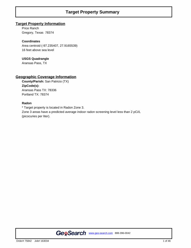
Target Property InformationPrice RanchGregory, Texas 78374
CoordinatesArea centroid (-97.235407, 27.9165539)16 feet above sea level
USGS QuadrangleAransas Pass, TX
Geographic Coverage InformationCounty/Parish: San Patricio (TX) ZipCode(s): Aransas Pass TX: 78336Portland TX: 78374
Radon* Target property is located in Radon Zone 3.Zone 3 areas have a predicted average indoor radon screening level less than 2 pCi/L (picocuries per liter).
1 of 46
www.geo-search.com 888-396-0042
Order# 75842 Job# 163034
Target Property Summary
FEDERAL LISTING
Standard Environmental Records
Database Acronym Locatable Unlocatable
SearchRadius(miles)
EMERGENCY RESPONSE NOTIFICATION SYSTEM ERNSTX 0 0 TP/AP
FEDERAL ENGINEERING INSTITUTIONAL CONTROL SITES EC 0 0 TP/AP
LAND USE CONTROL INFORMATION SYSTEM LUCIS 0 0 TP/AP
RCRA SITES WITH CONTROLS RCRASC 0 0 TP/AP
NO LONGER REGULATED RCRA GENERATOR FACILITIES NLRRCRAG 0 0 0.1250
RESOURCE CONSERVATION & RECOVERY ACT - GENERATOR RCRAGR06 0 0 0.1250
RESOURCE CONSERVATION & RECOVERY ACT - NON-GENERATOR
RCRANGR06 0 0 0.1250
BROWNFIELDS MANAGEMENT SYSTEM BF 0 0 0.5000
DELISTED NATIONAL PRIORITIES LIST DNPL 0 0 0.5000
NO LONGER REGULATED RCRA NON-CORRACTS TSD FACILITIES NLRRCRAT 0 0 0.5000
RESOURCE CONSERVATION & RECOVERY ACT - NON-CORRACTSTREATMENT, STORAGE & DISPOSAL FACILITIES
RCRAT 0 0 0.5000
SUPERFUND ENTERPRISE MANAGEMENT SYSTEM SEMS 0 0 0.5000
SUPERFUND ENTERPRISE MANAGEMENT SYSTEM ARCHIVEDSITE INVENTORY
SEMSARCH 0 0 0.5000
NATIONAL PRIORITIES LIST NPL 0 0 1.0000
NO LONGER REGULATED RCRA CORRECTIVE ACTION FACILITIES NLRRCRAC 0 0 1.0000
PROPOSED NATIONAL PRIORITIES LIST PNPL 0 0 1.0000
RESOURCE CONSERVATION & RECOVERY ACT - CORRECTIVEACTION FACILITIES
RCRAC 1 0 1.0000
RESOURCE CONSERVATION & RECOVERY ACT - SUBJECT TOCORRECTIVE ACTION FACILITIES
RCRASUBC 0 0 1.0000
SUB-TOTAL 1 0
Additional Environmental Records
Database Acronym Locatable Unlocatable
SearchRadius(miles)
AEROMETRIC INFORMATION RETRIEVAL SYSTEM / AIR FACILITYSUBSYSTEM
AIRSAFS 0 0 TP/AP
BIENNIAL REPORTING SYSTEM BRS 0 0 TP/AP
CERCLIS LIENS SFLIENS 0 0 TP/AP
CLANDESTINE DRUG LABORATORY LOCATIONS CDL 0 0 TP/AP
EPA DOCKET DATA DOCKETS 0 0 TP/AP
FACILITY REGISTRY SYSTEM FRSTX 0 0 TP/AP
2 of 46
www.geo-search.com 888-396-0042
Order# 75842 Job# 163034
Target Property SummaryDatabase Summary
Database Acronym Locatable Unlocatable
SearchRadius(miles)
HAZARDOUS MATERIALS INCIDENT REPORTING SYSTEM HMIRSR06 0 0 TP/AP
INTEGRATED COMPLIANCE INFORMATION SYSTEM (FORMERLYDOCKETS)
ICIS 0 0 TP/AP
INTEGRATED COMPLIANCE INFORMATION SYSTEM NATIONALPOLLUTANT DISCHARGE ELIMINATION SYSTEM
ICISNPDES 0 0 TP/AP
MATERIAL LICENSING TRACKING SYSTEM MLTS 0 0 TP/AP
NATIONAL POLLUTANT DISCHARGE ELIMINATION SYSTEM NPDESR06 0 0 TP/AP
PCB ACTIVITY DATABASE SYSTEM PADS 0 0 TP/AP
PERMIT COMPLIANCE SYSTEM PCSR06 0 0 TP/AP
SECTION SEVEN TRACKING SYSTEM SSTS 0 0 TP/AP
TOXIC SUBSTANCE CONTROL ACT INVENTORY TSCA 0 0 TP/AP
TOXICS RELEASE INVENTORY TRI 0 0 TP/AP
HISTORICAL GAS STATIONS HISTPST 0 0 0.2500
MINE SAFETY AND HEALTH ADMINISTRATION MASTER INDEX FILE MSHA 0 0 0.2500
OPEN DUMP INVENTORY ODI 0 0 0.5000
DEPARTMENT OF DEFENSE SITES DOD 0 0 1.0000
FORMERLY USED DEFENSE SITES FUDS 0 0 1.0000
RECORD OF DECISION SYSTEM RODS 0 0 1.0000
SUB-TOTAL 0 0
3 of 46
www.geo-search.com 888-396-0042
Order# 75842 Job# 163034
Target Property SummaryDatabase Summary
STATE (TX) LISTING
Standard Environmental Records
Database Acronym Locatable Unlocatable
SearchRadius(miles)
STATE INSTITUTIONAL/ENGINEERING CONTROL SITES SIEC01 0 0 TP/AP
DRY CLEANER REGISTRATION DATABASE DCR 0 0 0.2500
PETROLEUM STORAGE TANKS PST 0 0 0.2500
BROWNFIELDS SITE ASSESSMENTS BSA 0 0 0.5000
CLOSED & ABANDONED LANDFILL INVENTORY CALF 0 0 0.5000
LEAKING PETROLEUM STORAGE TANKS LPST 0 0 0.5000
MUNICIPAL SOLID WASTE LANDFILL SITES MSWLF 0 0 0.5000
RADIOACTIVE WASTE SITES RWS 0 0 0.5000
RAILROAD COMMISSION VCP AND BROWNFIELD SITES RRCVCP 0 0 0.5000
VOLUNTARY CLEANUP PROGRAM SITES VCP 0 0 0.5000
INDUSTRIAL AND HAZARDOUS WASTE CORRECTIVE ACTIONSITES
IHWCA 2 0 1.0000
STATE SUPERFUND SITES SF 0 0 1.0000
SUB-TOTAL 2 0
Additional Environmental Records
Database Acronym Locatable Unlocatable
SearchRadius(miles)
GROUNDWATER CONTAMINATION CASES GWCC 0 0 TP/AP
HISTORIC GROUNDWATER CONTAMINATION CASES HISTGWCC 0 0 TP/AP
MUNICIPAL SETTING DESIGNATIONS MSD 0 0 TP/AP
NOTICE OF VIOLATIONS NOV 0 0 TP/AP
SPILLS LISTING SPILLS 0 1 TP/AP
TCEQ LIENS LIENS 0 0 TP/AP
TIER I I CHEMICAL REPORTING PROGRAM FACILITIES TIERII 0 0 TP/AP
INDUSTRIAL AND HAZARDOUS WASTE SITES IHW 0 0 0.2500
PERMITTED INDUSTRIAL HAZARDOUS WASTE SITES PIHW 0 0 0.2500
AFFECTED PROPERTY ASSESSMENT REPORTS APAR 0 0 0.5000
DRY CLEANER REMEDIATION PROGRAM SITES DCRPS 0 0 0.5000
INNOCENT OWNER / OPERATOR DATABASE IOP 0 0 0.5000
RECYCLING FACILITIES WMRF 0 0 0.5000
SUB-TOTAL 0 1
4 of 46
www.geo-search.com 888-396-0042
Order# 75842 Job# 163034
Target Property SummaryDatabase Summary
TRIBAL LISTING
Standard Environmental Records
Database Acronym Locatable Unlocatable
SearchRadius(miles)
UNDERGROUND STORAGE TANKS ON TRIBAL LANDS USTR06 0 0 0.2500
LEAKING UNDERGROUND STORAGE TANKS ON TRIBAL LANDS LUSTR06 0 0 0.5000
OPEN DUMP INVENTORY ON TRIBAL LANDS ODINDIAN 0 0 0.5000
SUB-TOTAL 0 0
Additional Environmental Records
Database Acronym Locatable Unlocatable
SearchRadius(miles)
INDIAN RESERVATIONS INDIANRES 0 0 1.0000
SUB-TOTAL 0 0
TOTAL 3 1
5 of 46
www.geo-search.com 888-396-0042
Order# 75842 Job# 163034
Target Property SummaryDatabase Summary
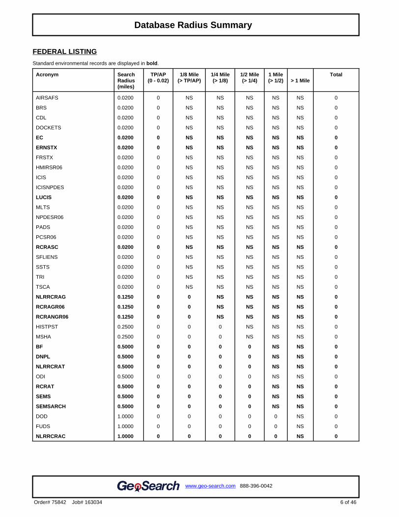
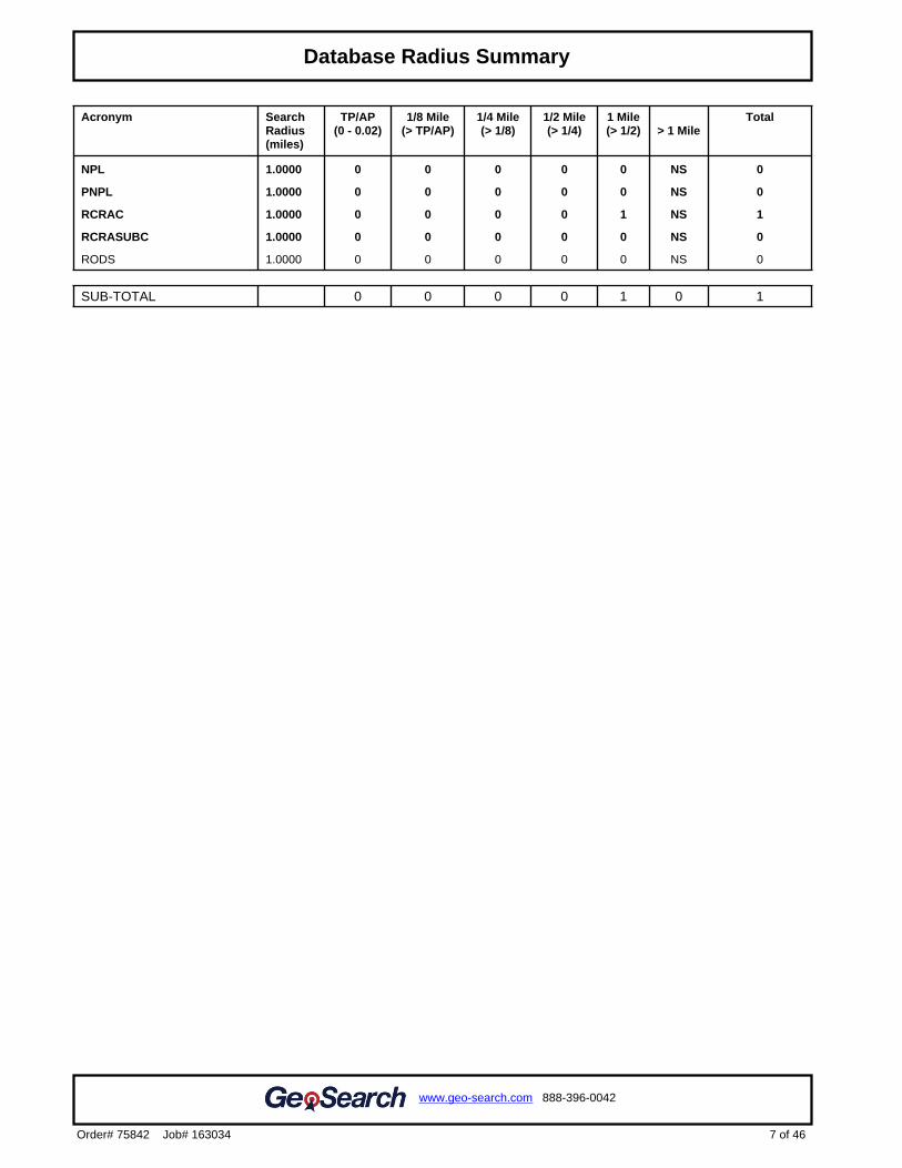
FEDERAL LISTING
Standard environmental records are displayed in bold.
Acronym SearchRadius(miles)
TP/AP(0 - 0.02)
1/8 Mile(> TP/AP)
1/4 Mile(> 1/8)
1/2 Mile(> 1/4)
1 Mile(> 1/2) > 1 Mile
Total
AIRSAFS 0.0200 0 NS NS NS NS NS 0
BRS 0.0200 0 NS NS NS NS NS 0
CDL 0.0200 0 NS NS NS NS NS 0
DOCKETS 0.0200 0 NS NS NS NS NS 0
EC 0.0200 0 NS NS NS NS NS 0
ERNSTX 0.0200 0 NS NS NS NS NS 0
FRSTX 0.0200 0 NS NS NS NS NS 0
HMIRSR06 0.0200 0 NS NS NS NS NS 0
ICIS 0.0200 0 NS NS NS NS NS 0
ICISNPDES 0.0200 0 NS NS NS NS NS 0
LUCIS 0.0200 0 NS NS NS NS NS 0
MLTS 0.0200 0 NS NS NS NS NS 0
NPDESR06 0.0200 0 NS NS NS NS NS 0
PADS 0.0200 0 NS NS NS NS NS 0
PCSR06 0.0200 0 NS NS NS NS NS 0
RCRASC 0.0200 0 NS NS NS NS NS 0
SFLIENS 0.0200 0 NS NS NS NS NS 0
SSTS 0.0200 0 NS NS NS NS NS 0
TRI 0.0200 0 NS NS NS NS NS 0
TSCA 0.0200 0 NS NS NS NS NS 0
NLRRCRAG 0.1250 0 0 NS NS NS NS 0
RCRAGR06 0.1250 0 0 NS NS NS NS 0
RCRANGR06 0.1250 0 0 NS NS NS NS 0
HISTPST 0.2500 0 0 0 NS NS NS 0
MSHA 0.2500 0 0 0 NS NS NS 0
BF 0.5000 0 0 0 0 NS NS 0
DNPL 0.5000 0 0 0 0 NS NS 0
NLRRCRAT 0.5000 0 0 0 0 NS NS 0
ODI 0.5000 0 0 0 0 NS NS 0
RCRAT 0.5000 0 0 0 0 NS NS 0
SEMS 0.5000 0 0 0 0 NS NS 0
SEMSARCH 0.5000 0 0 0 0 NS NS 0
DOD 1.0000 0 0 0 0 0 NS 0
FUDS 1.0000 0 0 0 0 0 NS 0
NLRRCRAC 1.0000 0 0 0 0 0 NS 0
6 of 46
www.geo-search.com 888-396-0042
Order# 75842 Job# 163034
Target Property SummaryDatabase SummaryDatabase Radius Summary
Acronym SearchRadius(miles)
TP/AP(0 - 0.02)
1/8 Mile(> TP/AP)
1/4 Mile(> 1/8)
1/2 Mile(> 1/4)
1 Mile(> 1/2) > 1 Mile
Total
NPL 1.0000 0 0 0 0 0 NS 0
PNPL 1.0000 0 0 0 0 0 NS 0
RCRAC 1.0000 0 0 0 0 1 NS 1
RCRASUBC 1.0000 0 0 0 0 0 NS 0
RODS 1.0000 0 0 0 0 0 NS 0
SUB-TOTAL 0 0 0 0 1 0 1
7 of 46
www.geo-search.com 888-396-0042
Order# 75842 Job# 163034
Target Property SummaryDatabase SummaryDatabase Radius Summary
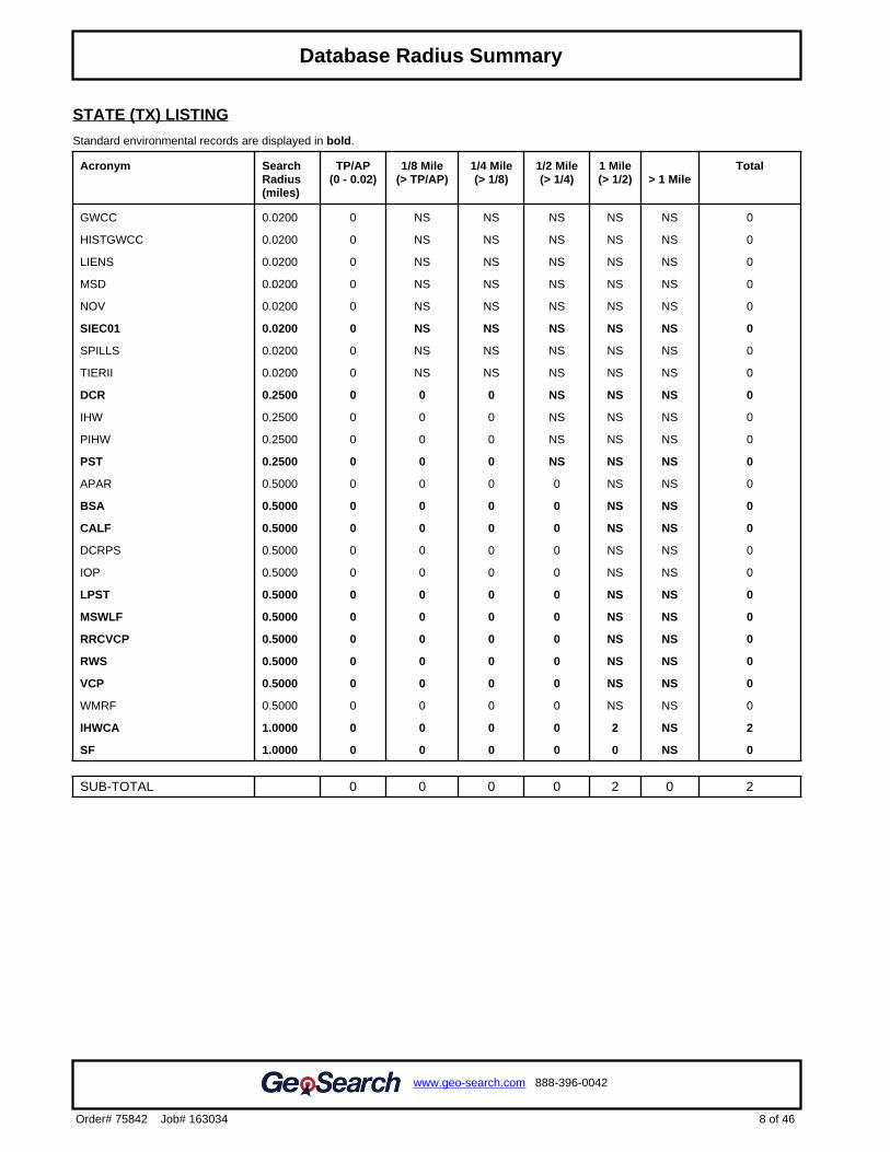
STATE (TX) LISTING
Standard environmental records are displayed in bold.
Acronym SearchRadius(miles)
TP/AP(0 - 0.02)
1/8 Mile(> TP/AP)
1/4 Mile(> 1/8)
1/2 Mile(> 1/4)
1 Mile(> 1/2) > 1 Mile
Total
GWCC 0.0200 0 NS NS NS NS NS 0
HISTGWCC 0.0200 0 NS NS NS NS NS 0
LIENS 0.0200 0 NS NS NS NS NS 0
MSD 0.0200 0 NS NS NS NS NS 0
NOV 0.0200 0 NS NS NS NS NS 0
SIEC01 0.0200 0 NS NS NS NS NS 0
SPILLS 0.0200 0 NS NS NS NS NS 0
TIERII 0.0200 0 NS NS NS NS NS 0
DCR 0.2500 0 0 0 NS NS NS 0
IHW 0.2500 0 0 0 NS NS NS 0
PIHW 0.2500 0 0 0 NS NS NS 0
PST 0.2500 0 0 0 NS NS NS 0
APAR 0.5000 0 0 0 0 NS NS 0
BSA 0.5000 0 0 0 0 NS NS 0
CALF 0.5000 0 0 0 0 NS NS 0
DCRPS 0.5000 0 0 0 0 NS NS 0
IOP 0.5000 0 0 0 0 NS NS 0
LPST 0.5000 0 0 0 0 NS NS 0
MSWLF 0.5000 0 0 0 0 NS NS 0
RRCVCP 0.5000 0 0 0 0 NS NS 0
RWS 0.5000 0 0 0 0 NS NS 0
VCP 0.5000 0 0 0 0 NS NS 0
WMRF 0.5000 0 0 0 0 NS NS 0
IHWCA 1.0000 0 0 0 0 2 NS 2
SF 1.0000 0 0 0 0 0 NS 0
SUB-TOTAL 0 0 0 0 2 0 2
8 of 46
www.geo-search.com 888-396-0042
Order# 75842 Job# 163034
Target Property SummaryDatabase SummaryDatabase Radius Summary

TRIBAL LISTING
Standard environmental records are displayed in bold.
Acronym SearchRadius(miles)
TP/AP(0 - 0.02)
1/8 Mile(> TP/AP)
1/4 Mile(> 1/8)
1/2 Mile(> 1/4)
1 Mile(> 1/2) > 1 Mile
Total
USTR06 0.2500 0 0 0 NS NS NS 0
LUSTR06 0.5000 0 0 0 0 NS NS 0
ODINDIAN 0.5000 0 0 0 0 NS NS 0
INDIANRES 1.0000 0 0 0 0 0 NS 0
SUB-TOTAL 0 0 0 0 0 0 0
TOTAL 0 0 0 0 3 0 3
NOTES:NS = NOT SEARCHEDTP/AP = TARGET PROPERTY/ADJACENT PROPERTY
9 of 46
www.geo-search.com 888-396-0042
Order# 75842 Job# 163034
Target Property SummaryDatabase SummaryDatabase Radius Summary
.2
Click here to access Satellite view
10 of 46
www.geo-search.com 888-396-0042
Order# 75842 Job# 163034
Target Property SummaryDatabase SummaryDatabase Radius SummaryRadius Map 1
.3
Click here to access Satellite view
11 of 46
www.geo-search.com 888-396-0042
Order# 75842 Job# 163034
Target Property SummaryDatabase SummaryDatabase Radius SummaryRadius Map 2
.4
Click here to access Satellite view
12 of 46
www.geo-search.com 888-396-0042
Order# 75842 Job# 163034
Target Property SummaryDatabase SummaryDatabase Radius SummaryOrtho Map
.5
Click here to access Satellite view
13 of 46
www.geo-search.com 888-396-0042
Order# 75842 Job# 163034
Target Property SummaryDatabase SummaryDatabase Radius SummaryTopographic Map
NOTE: Standard environmental records are displayed in bold.
Map ID#
DatabaseName
Site ID# RelativeElevation
DistanceFrom Site
Site Name Address PAGE#
1 IHWCA 38280 Higher(18 ft.)
0.94 mi. S(4963 ft.)
OXYCHEMINGLESIDE PLANT
4133 HWY 361, GREGORY, TX78359
16
1 RCRAC TXD063101794 Higher(18 ft.)
0.94 mi. S(4963 ft.)
THE CHEMOURSCOMPANY FCINGLESIDE PLANT
4127 HIGHWAY 361, INGLESIDE,TX 78362
17
1 IHWCA 30018 Higher(18 ft.)
0.94 mi. S(4963 ft.)
THE CHEMOURSCOMPANY FCINGLESIDE PLANT
TX 28
14 of 46
www.geo-search.com 888-396-0042
Order# 75842 Job# 163034
Target Property SummaryDatabase SummaryDatabase Radius SummaryLocated Sites Summary
Elevations are collected from the USGS 3D Elevation Program 1/3 arc-second (approximately 10 meters) layer hosted at the NGTOC. .
Target Property Elevation: 16 ft.NOTE: Standard environmental records are displayed in bold.
EQUAL/HIGHER ELEVATION
Map ID#
Database Name Elevation Site Name Address Page#
1 IHWCA 18 ft. OXYCHEM INGLESIDE PLANT 4133 HWY 361, GREGORY, TX 78359 16
1 RCRAC 18 ft. THE CHEMOURS COMPANY FCINGLESIDE PLANT
4127 HIGHWAY 361, INGLESIDE, TX78362
17
1 IHWCA 18 ft. THE CHEMOURS COMPANY FCINGLESIDE PLANT
TX 28
LOWER ELEVATION
No Records Found
15 of 46
www.geo-search.com 888-396-0042
Order# 75842 Job# 163034
Target Property SummaryDatabase SummaryDatabase Radius SummaryLocated Sites SummaryElevation Summary
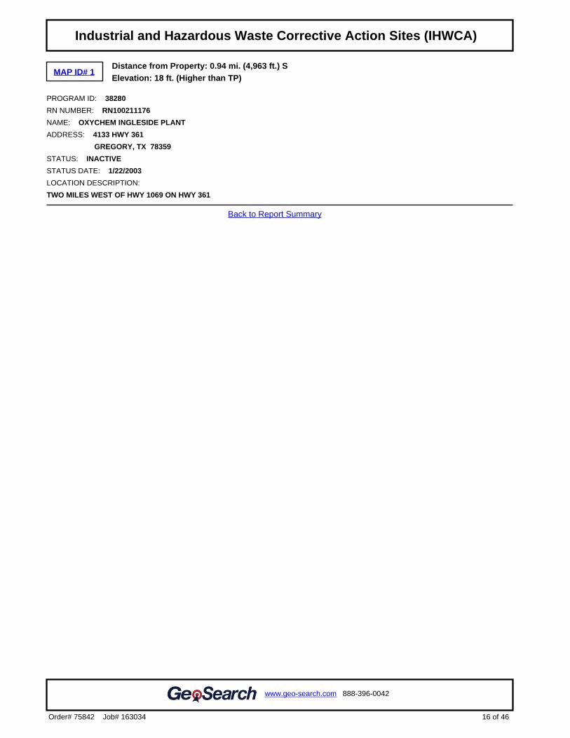
MAP ID# 1Distance from Property: 0.94 mi. (4,963 ft.) SElevation: 18 ft. (Higher than TP)
PROGRAM ID: 38280
RN NUMBER: RN100211176
NAME: OXYCHEM INGLESIDE PLANT
ADDRESS: 4133 HWY 361
GREGORY, TX 78359
STATUS: INACTIVE
STATUS DATE: 1/22/2003
LOCATION DESCRIPTION:
TWO MILES WEST OF HWY 1069 ON HWY 361
Back to Report Summary
16 of 46
www.geo-search.com 888-396-0042
Order# 75842 Job# 163034
Target Property SummaryDatabase SummaryDatabase Radius SummaryLocated Sites SummaryElevation SummaryIndustrial and Hazardous Waste Corrective Action Sites (IHWCA)
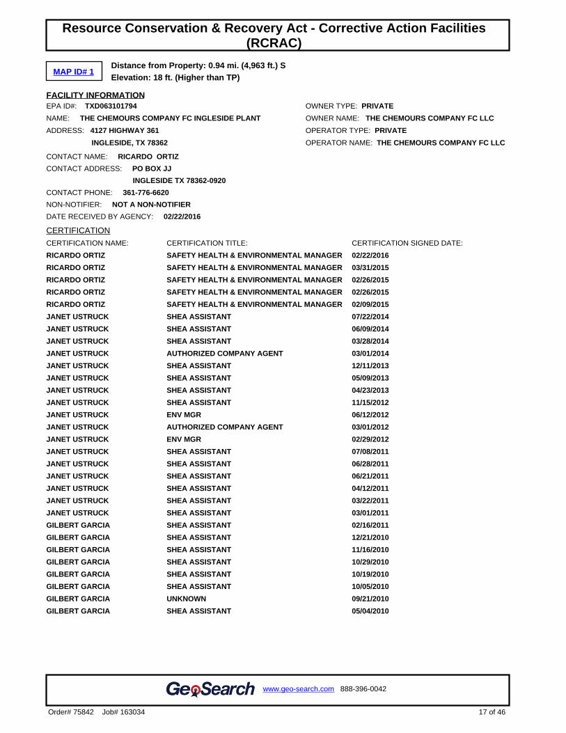
MAP ID# 1Distance from Property: 0.94 mi. (4,963 ft.) SElevation: 18 ft. (Higher than TP)
FACILITY INFORMATIONEPA ID#: TXD063101794 OWNER TYPE: PRIVATE
NAME: THE CHEMOURS COMPANY FC INGLESIDE PLANT OWNER NAME: THE CHEMOURS COMPANY FC LLC
ADDRESS: 4127 HIGHWAY 361 OPERATOR TYPE: PRIVATE
INGLESIDE, TX 78362 OPERATOR NAME: THE CHEMOURS COMPANY FC LLC
CONTACT NAME: RICARDO ORTIZ
CONTACT ADDRESS: PO BOX JJ
INGLESIDE TX 78362-0920
CONTACT PHONE: 361-776-6620
NON-NOTIFIER: NOT A NON-NOTIFIER
DATE RECEIVED BY AGENCY: 02/22/2016
CERTIFICATION
CERTIFICATION NAME: CERTIFICATION TITLE: CERTIFICATION SIGNED DATE:
RICARDO ORTIZ SAFETY HEALTH & ENVIRONMENTAL MANAGER 02/22/2016
RICARDO ORTIZ SAFETY HEALTH & ENVIRONMENTAL MANAGER 03/31/2015
RICARDO ORTIZ SAFETY HEALTH & ENVIRONMENTAL MANAGER 02/26/2015
RICARDO ORTIZ SAFETY HEALTH & ENVIRONMENTAL MANAGER 02/26/2015
RICARDO ORTIZ SAFETY HEALTH & ENVIRONMENTAL MANAGER 02/09/2015
JANET USTRUCK SHEA ASSISTANT 07/22/2014
JANET USTRUCK SHEA ASSISTANT 06/09/2014
JANET USTRUCK SHEA ASSISTANT 03/28/2014
JANET USTRUCK AUTHORIZED COMPANY AGENT 03/01/2014
JANET USTRUCK SHEA ASSISTANT 12/11/2013
JANET USTRUCK SHEA ASSISTANT 05/09/2013
JANET USTRUCK SHEA ASSISTANT 04/23/2013
JANET USTRUCK SHEA ASSISTANT 11/15/2012
JANET USTRUCK ENV MGR 06/12/2012
JANET USTRUCK AUTHORIZED COMPANY AGENT 03/01/2012
JANET USTRUCK ENV MGR 02/29/2012
JANET USTRUCK SHEA ASSISTANT 07/08/2011
JANET USTRUCK SHEA ASSISTANT 06/28/2011
JANET USTRUCK SHEA ASSISTANT 06/21/2011
JANET USTRUCK SHEA ASSISTANT 04/12/2011
JANET USTRUCK SHEA ASSISTANT 03/22/2011
JANET USTRUCK SHEA ASSISTANT 03/01/2011
GILBERT GARCIA SHEA ASSISTANT 02/16/2011
GILBERT GARCIA SHEA ASSISTANT 12/21/2010
GILBERT GARCIA SHEA ASSISTANT 11/16/2010
GILBERT GARCIA SHEA ASSISTANT 10/29/2010
GILBERT GARCIA SHEA ASSISTANT 10/19/2010
GILBERT GARCIA SHEA ASSISTANT 10/05/2010
GILBERT GARCIA UNKNOWN 09/21/2010
GILBERT GARCIA SHEA ASSISTANT 05/04/2010
17 of 46
www.geo-search.com 888-396-0042
Order# 75842 Job# 163034
Target Property SummaryDatabase SummaryDatabase Radius SummaryLocated Sites SummaryElevation SummaryIndustrial and Hazardous Waste Corrective Action Sites (IHWCA)Resource Conservation & Recovery Act - Corrective Action Facilities(RCRAC)
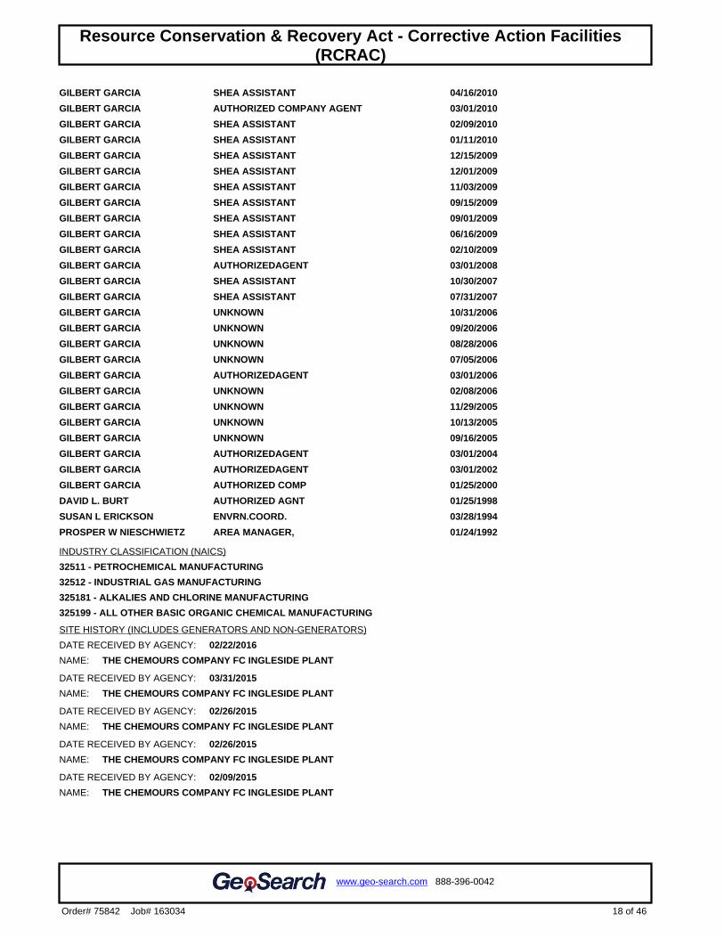
GILBERT GARCIA SHEA ASSISTANT 04/16/2010
GILBERT GARCIA AUTHORIZED COMPANY AGENT 03/01/2010
GILBERT GARCIA SHEA ASSISTANT 02/09/2010
GILBERT GARCIA SHEA ASSISTANT 01/11/2010
GILBERT GARCIA SHEA ASSISTANT 12/15/2009
GILBERT GARCIA SHEA ASSISTANT 12/01/2009
GILBERT GARCIA SHEA ASSISTANT 11/03/2009
GILBERT GARCIA SHEA ASSISTANT 09/15/2009
GILBERT GARCIA SHEA ASSISTANT 09/01/2009
GILBERT GARCIA SHEA ASSISTANT 06/16/2009
GILBERT GARCIA SHEA ASSISTANT 02/10/2009
GILBERT GARCIA AUTHORIZEDAGENT 03/01/2008
GILBERT GARCIA SHEA ASSISTANT 10/30/2007
GILBERT GARCIA SHEA ASSISTANT 07/31/2007
GILBERT GARCIA UNKNOWN 10/31/2006
GILBERT GARCIA UNKNOWN 09/20/2006
GILBERT GARCIA UNKNOWN 08/28/2006
GILBERT GARCIA UNKNOWN 07/05/2006
GILBERT GARCIA AUTHORIZEDAGENT 03/01/2006
GILBERT GARCIA UNKNOWN 02/08/2006
GILBERT GARCIA UNKNOWN 11/29/2005
GILBERT GARCIA UNKNOWN 10/13/2005
GILBERT GARCIA UNKNOWN 09/16/2005
GILBERT GARCIA AUTHORIZEDAGENT 03/01/2004
GILBERT GARCIA AUTHORIZEDAGENT 03/01/2002
GILBERT GARCIA AUTHORIZED COMP 01/25/2000
DAVID L. BURT AUTHORIZED AGNT 01/25/1998
SUSAN L ERICKSON ENVRN.COORD. 03/28/1994
PROSPER W NIESCHWIETZ AREA MANAGER, 01/24/1992
INDUSTRY CLASSIFICATION (NAICS)
32511 - PETROCHEMICAL MANUFACTURING
32512 - INDUSTRIAL GAS MANUFACTURING
325181 - ALKALIES AND CHLORINE MANUFACTURING
325199 - ALL OTHER BASIC ORGANIC CHEMICAL MANUFACTURING
SITE HISTORY (INCLUDES GENERATORS AND NON-GENERATORS)
DATE RECEIVED BY AGENCY: 02/22/2016
NAME: THE CHEMOURS COMPANY FC INGLESIDE PLANT
DATE RECEIVED BY AGENCY: 03/31/2015
NAME: THE CHEMOURS COMPANY FC INGLESIDE PLANT
DATE RECEIVED BY AGENCY: 02/26/2015
NAME: THE CHEMOURS COMPANY FC INGLESIDE PLANT
DATE RECEIVED BY AGENCY: 02/26/2015
NAME: THE CHEMOURS COMPANY FC INGLESIDE PLANT
DATE RECEIVED BY AGENCY: 02/09/2015
NAME: THE CHEMOURS COMPANY FC INGLESIDE PLANT
18 of 46
www.geo-search.com 888-396-0042
Order# 75842 Job# 163034
Target Property SummaryDatabase SummaryDatabase Radius SummaryLocated Sites SummaryElevation SummaryIndustrial and Hazardous Waste Corrective Action Sites (IHWCA)Resource Conservation & Recovery Act - Corrective Action Facilities(RCRAC)
DATE RECEIVED BY AGENCY: 07/22/2014
NAME: E I DU PONT DE NEMOURS CORPUS CHRISTI
DATE RECEIVED BY AGENCY: 06/09/2014
NAME: E I DU PONT DE NEMOURS CORPUS CHRISTI
DATE RECEIVED BY AGENCY: 03/28/2014
NAME: E I DU PONT DE NEMOURS CORPUS CHRISTI
DATE RECEIVED BY AGENCY: 03/01/2014
NAME: E I DU PONT DE NEMOURS CORPUS CHRISTI
DATE RECEIVED BY AGENCY: 12/11/2013
NAME: E I DU PONT DE NEMOURS CORPUS CHRISTI
DATE RECEIVED BY AGENCY: 05/09/2013
NAME: E I DU PONT DE NEMOURS CORPUS CHRISTI
DATE RECEIVED BY AGENCY: 04/23/2013
NAME: E I DU PONT DE NEMOURS CORPUS CHRISTI
DATE RECEIVED BY AGENCY: 11/15/2012
NAME: E I DU PONT DE NEMOURS CORPUS CHRISTI
DATE RECEIVED BY AGENCY: 06/12/2012
NAME: E I DU PONT DE NEMOURS AND CO - CORPUS CHRISTI
DATE RECEIVED BY AGENCY: 03/01/2012
NAME: E I DU PONT DE NEMOURS CORPUS CHRISTI
DATE RECEIVED BY AGENCY: 02/29/2012
NAME: E I DU PONT DE NEMOURS AND COMPANY
DATE RECEIVED BY AGENCY: 07/08/2011
NAME: E I DU PONT DE NEMOURS CORPUS CHRISTI
DATE RECEIVED BY AGENCY: 06/28/2011
NAME: E I DU PONT DE NEMOURS CORPUS CHRISTI
DATE RECEIVED BY AGENCY: 06/21/2011
NAME: E I DU PONT DE NEMOURS CORPUS CHRISTI
DATE RECEIVED BY AGENCY: 04/12/2011
NAME: E I DU PONT DE NEMOURS CORPUS CHRISTI
DATE RECEIVED BY AGENCY: 03/22/2011
NAME: E I DU PONT DE NEMOURS CORPUS CHRISTI
DATE RECEIVED BY AGENCY: 03/01/2011
NAME: E I DU PONT DE NEMOURS CORPUS CHRISTI
DATE RECEIVED BY AGENCY: 02/16/2011
NAME: E I DU PONT DE NEMOURS CORPUS CHRISTI
DATE RECEIVED BY AGENCY: 12/21/2010
NAME: E I DU PONT DE NEMOURS CORPUS CHRISTI
DATE RECEIVED BY AGENCY: 11/16/2010
NAME: E I DU PONT DE NEMOURS CORPUS CHRISTI
DATE RECEIVED BY AGENCY: 10/29/2010
NAME: E I DU PONT DE NEMOURS CORPUS CHRISTI
DATE RECEIVED BY AGENCY: 10/19/2010
NAME: E I DU PONT DE NEMOURS CORPUS CHRISTI
19 of 46
www.geo-search.com 888-396-0042
Order# 75842 Job# 163034
Target Property SummaryDatabase SummaryDatabase Radius SummaryLocated Sites SummaryElevation SummaryIndustrial and Hazardous Waste Corrective Action Sites (IHWCA)Resource Conservation & Recovery Act - Corrective Action Facilities(RCRAC)
DATE RECEIVED BY AGENCY: 10/05/2010
NAME: E I DU PONT DE NEMOURS CORPUS CHRISTI
DATE RECEIVED BY AGENCY: 09/21/2010
NAME: E I DU PONT DE NEMOURS AND COMPANY
DATE RECEIVED BY AGENCY: 05/04/2010
NAME: E I DU PONT DE NEMOURS AND COMPANY
DATE RECEIVED BY AGENCY: 04/16/2010
NAME: E I DU PONT DE NEMOURS AND COMPANY
DATE RECEIVED BY AGENCY: 03/01/2010
NAME: E I DU PONT DE NEMOURS AND COMPANY
DATE RECEIVED BY AGENCY: 02/09/2010
NAME: E I DU PONT DE NEMOURS AND COMPANY
DATE RECEIVED BY AGENCY: 01/11/2010
NAME: E I DU PONT DE NEMOURS AND COMPANY
DATE RECEIVED BY AGENCY: 12/15/2009
NAME: E I DU PONT DE NEMOURS AND COMPANY
DATE RECEIVED BY AGENCY: 12/01/2009
NAME: E I DU PONT DE NEMOURS AND COMPANY
DATE RECEIVED BY AGENCY: 11/03/2009
NAME: E I DU PONT DE NEMOURS AND COMPANY
DATE RECEIVED BY AGENCY: 09/15/2009
NAME: E I DU PONT DE NEMOURS AND COMPANY
DATE RECEIVED BY AGENCY: 09/01/2009
NAME: E I DU PONT DE NEMOURS AND COMPANY
DATE RECEIVED BY AGENCY: 06/16/2009
NAME: E I DU PONT DE NEMOURS AND COMPANY
DATE RECEIVED BY AGENCY: 02/10/2009
NAME: E I DU PONT DE NEMOURS AND COMPANY
DATE RECEIVED BY AGENCY: 03/01/2008
NAME: E I DU PONT DE NEMOURS AND COMPANY
DATE RECEIVED BY AGENCY: 10/30/2007
NAME: E I DU PONT DE NEMOURS AND COMPANY
DATE RECEIVED BY AGENCY: 07/31/2007
NAME: E I DU PONT DE NEMOURS AND COMPANY
DATE RECEIVED BY AGENCY: 10/31/2006
NAME: E I DU PONT DE NEMOURS AND COMPANY
DATE RECEIVED BY AGENCY: 09/20/2006
NAME: E I DU PONT DE NEMOURS AND COMPANY
DATE RECEIVED BY AGENCY: 08/28/2006
NAME: E I DU PONT DE NEMOURS AND COMPANY
DATE RECEIVED BY AGENCY: 07/05/2006
NAME: E I DU PONT DE NEMOURS AND COMPANY
DATE RECEIVED BY AGENCY: 03/01/2006
NAME: E I DU PONT DE NEMOURS AND COMPANY
20 of 46
www.geo-search.com 888-396-0042
Order# 75842 Job# 163034
Target Property SummaryDatabase SummaryDatabase Radius SummaryLocated Sites SummaryElevation SummaryIndustrial and Hazardous Waste Corrective Action Sites (IHWCA)Resource Conservation & Recovery Act - Corrective Action Facilities(RCRAC)
DATE RECEIVED BY AGENCY: 02/08/2006
NAME: E I DU PONT DE NEMOURS AND COMPANY
DATE RECEIVED BY AGENCY: 11/29/2005
NAME: E I DU PONT DE NEMOURS AND COMPANY
DATE RECEIVED BY AGENCY: 10/13/2005
NAME: E I DU PONT DE NEMOURS AND COMPANY
DATE RECEIVED BY AGENCY: 09/16/2005
NAME: E I DU PONT DE NEMOURS AND COMPANY
DATE RECEIVED BY AGENCY: 03/01/2004
NAME: E I DU PONT DE NEMOURS AND COMPANY
DATE RECEIVED BY AGENCY: 11/14/2003
NAME: E I DU PONT DE NEMOURS AND COMPANY
DATE RECEIVED BY AGENCY: 01/08/2003
NAME: E I DU PONT DE NEMOURS CORPUS CHRISTI
DATE RECEIVED BY AGENCY: 03/01/2002
NAME: E I DU PONT DE NEMOURS AND COMPANY
DATE RECEIVED BY AGENCY: 07/25/2000
NAME: E I DUPONT DE NEMOURS
DATE RECEIVED BY AGENCY: 01/25/2000
NAME: E. I. DUPONT DE NEMOURS & CO.
DATE RECEIVED BY AGENCY: 01/25/1998
NAME: E.I. DUPONT DE NEMOURS & CO. - CORPUS CH
DATE RECEIVED BY AGENCY: 03/01/1996
NAME: E. I. DUPONT DE NEMOURS & CO.
DATE RECEIVED BY AGENCY: 03/28/1994
NAME: E.I. DU PONT DE NEMOURS & CO., INC.
DATE RECEIVED BY AGENCY: 01/24/1992
NAME: E.I. DUPONT DE NEMOURS & CO.
DATE RECEIVED BY AGENCY: 03/01/1990
NAME: E I DUPONT DE NEMOURS
CURRENT ACTIVITY INFORMATION
GENERATOR STATUS: LARGE QUANTITY GENERATOR LAST UPDATED DATE: 04/15/2016
SUBJECT TO CORRECTIVE ACTION UNIVERSE: YES
TDSFs POTENTIALLY SUBJECT TO CORRECTIVE ACTION UNDER 3004 (u)/(v) UNIVERSE: NO
TDSFs ONLY SUBJECT TO CORRECTIVE ACTION UNDER DISCRETIONARY AUTHORITIES UNIVERSE: YES
NON TSDFs WHERE RCRA CORRECTIVE ACTION HAS BEEN IMPOSED UNIVERSE: NO
CORRECTIVE ACTION WORKLOAD UNIVERSE: YES
IMPORTER: NO UNDERGROUND INJECTION: NO
MIXED WASTE GENERATOR: NO UNIVERSAL WASTE DESTINATION FACILITY: NO
RECYCLER: NO TRANSFER FACILITY: NO
TRANSPORTER: NO USED OIL FUEL BURNER: NO
ONSITE BURNER EXEMPTION: NO USED OIL PROCESSOR: NO
FURNACE EXEMPTION: NO USED OIL FUEL MARKETER TO BURNER: NO
USED OIL REFINER: NO SPECIFICATION USED OIL MARKETER: NO
21 of 46
www.geo-search.com 888-396-0042
Order# 75842 Job# 163034
Target Property SummaryDatabase SummaryDatabase Radius SummaryLocated Sites SummaryElevation SummaryIndustrial and Hazardous Waste Corrective Action Sites (IHWCA)Resource Conservation & Recovery Act - Corrective Action Facilities(RCRAC)
USED OIL TRANSFER FACILITY: NO USED OIL TRANSPORTER: NO
COMPLIANCE, MONITORING AND ENFORCEMENT INFORMATION
EVALUATIONS06/18/2014 CEI COMPLIANCE EVALUATION INSPECTION ON-SITE
04/21/2014 OAM OPERATION AND MAINTENANCE INSPECTION
10/24/2011 NRR NON-FINANCIAL RECORD REVIEW
04/13/2011 OAM OPERATION AND MAINTENANCE INSPECTION
10/04/2010 CEI COMPLIANCE EVALUATION INSPECTION ON-SITE
02/16/2010 NRR NON-FINANCIAL RECORD REVIEW
02/08/2010 CDI CASE DEVELOPMENT INSPECTION
02/08/2010 NRR NON-FINANCIAL RECORD REVIEW
10/22/2009 CEI COMPLIANCE EVALUATION INSPECTION ON-SITE
12/02/2008 CEI COMPLIANCE EVALUATION INSPECTION ON-SITE
10/25/2007 CEI COMPLIANCE EVALUATION INSPECTION ON-SITE
10/25/2007 FCI FOCUSED COMPLIANCE INSPECTION
10/25/2006 CEI COMPLIANCE EVALUATION INSPECTION ON-SITE
09/12/2005 CEI COMPLIANCE EVALUATION INSPECTION ON-SITE
04/29/2004 CEI COMPLIANCE EVALUATION INSPECTION ON-SITE
01/15/2003 CEI COMPLIANCE EVALUATION INSPECTION ON-SITE
04/17/2002 CEI COMPLIANCE EVALUATION INSPECTION ON-SITE
06/19/2001 CEI COMPLIANCE EVALUATION INSPECTION ON-SITE
04/14/1999 CEI COMPLIANCE EVALUATION INSPECTION ON-SITE
02/17/1998 CEI COMPLIANCE EVALUATION INSPECTION ON-SITE
05/22/1997 CEI COMPLIANCE EVALUATION INSPECTION ON-SITE
09/19/1996 NRR NON-FINANCIAL RECORD REVIEW
02/07/1996 CEI COMPLIANCE EVALUATION INSPECTION ON-SITE
10/26/1994 CEI COMPLIANCE EVALUATION INSPECTION ON-SITE
08/12/1994 FCI FOCUSED COMPLIANCE INSPECTION
02/23/1994 CEI COMPLIANCE EVALUATION INSPECTION ON-SITE
07/22/1993 FCI FOCUSED COMPLIANCE INSPECTION
10/13/1992 CEI COMPLIANCE EVALUATION INSPECTION ON-SITE
10/12/1992 NRR NON-FINANCIAL RECORD REVIEW
08/25/1992 FCI FOCUSED COMPLIANCE INSPECTION
06/05/1992 CEI COMPLIANCE EVALUATION INSPECTION ON-SITE
03/10/1992 NRR NON-FINANCIAL RECORD REVIEW
08/22/1991 FCI FOCUSED COMPLIANCE INSPECTION
04/17/1991 NRR NON-FINANCIAL RECORD REVIEW
12/19/1990 CEI COMPLIANCE EVALUATION INSPECTION ON-SITE
11/17/1988 CEI COMPLIANCE EVALUATION INSPECTION ON-SITE
03/26/1986 CEI COMPLIANCE EVALUATION INSPECTION ON-SITE
VIOLATIONS06/18/2014 262.C GENERATORS - PRE-TRANSPORT
06/18/2014 265.I TSD IS-CONTAINER USE AND MANAGEMENT
06/18/2014 273.B UNIVERSAL WASTE - SMALL QUANTITY HANDLERS
06/18/2014 279.C USED OIL - GENERATORS
22 of 46
www.geo-search.com 888-396-0042
Order# 75842 Job# 163034
Target Property SummaryDatabase SummaryDatabase Radius SummaryLocated Sites SummaryElevation SummaryIndustrial and Hazardous Waste Corrective Action Sites (IHWCA)Resource Conservation & Recovery Act - Corrective Action Facilities(RCRAC)
06/18/2014 XXS STATE STATUTE OR REGULATION
10/24/2011 262.C GENERATORS - PRE-TRANSPORT
11/29/2010 262.B GENERATORS - MANIFEST
11/29/2010 XXS STATE STATUTE OR REGULATION
10/06/2010 262.A GENERATORS - GENERAL
10/06/2010 262.C GENERATORS - PRE-TRANSPORT
10/06/2010 265.I TSD IS-CONTAINER USE AND MANAGEMENT
10/06/2010 265.J TSD IS-TANK SYSTEM STANDARDS
10/06/2010 279.C USED OIL - GENERATORS
10/06/2010 XXS STATE STATUTE OR REGULATION
10/04/2010 262.C GENERATORS - PRE-TRANSPORT
10/04/2010 265.I TSD IS-CONTAINER USE AND MANAGEMENT
02/08/2010 262.B GENERATORS - MANIFEST
02/08/2010 270.A PERMITS - GENERAL INFORMATION
10/22/2009 262.A GENERATORS - GENERAL
10/22/2009 262.D GENERATORS - RECORDS/REPORTING
10/22/2009 268.A LDR - GENERAL
10/22/2009 273.B UNIVERSAL WASTE - SMALL QUANTITY HANDLERS
10/22/2009 XXS STATE STATUTE OR REGULATION
10/25/2007 262.C GENERATORS - PRE-TRANSPORT
10/25/2007 265.I TSD IS-CONTAINER USE AND MANAGEMENT
06/19/2001 262.A GENERATORS - GENERAL
02/17/1998 262.A GENERATORS - GENERAL
02/17/1998 XXS STATE STATUTE OR REGULATION
02/07/1996 XXS STATE STATUTE OR REGULATION
02/23/1994 262.A GENERATORS - GENERAL
06/05/1992 262.A GENERATORS - GENERAL
03/10/1992 265.R TSD IS-UNDERGROUND INJECTION
08/22/1991 265.R TSD IS-UNDERGROUND INJECTION
12/19/1990 264.A TSD - GENERAL
12/19/1990 268.A LDR - GENERAL
12/19/1990 XXS STATE STATUTE OR REGULATION
11/17/1988 264.A TSD - GENERAL
03/26/1986 264.A TSD - GENERAL
03/26/1986 XXS STATE STATUTE OR REGULATION
ENFORCEMENTS
08/18/2014 120 WRITTEN INFORMAL
11/17/2011 120 WRITTEN INFORMAL
01/11/2011 126 PROPOSED CONSENT ADMIN ORDER
01/11/2011 210 INITIAL 3008(A) COMPLIANCE
12/08/2010 141 REFERRAL TO ESC ENFORCEMENT SCREEN COMM.
12/03/2010 140 LETTER OF INTENT TO INITIATE ENFORCEMENT ACTION
12/29/2009 120 WRITTEN INFORMAL
11/09/2007 110 VERBAL INFORMAL
07/03/2001 110 VERBAL INFORMAL
23 of 46
www.geo-search.com 888-396-0042
Order# 75842 Job# 163034
Target Property SummaryDatabase SummaryDatabase Radius SummaryLocated Sites SummaryElevation SummaryIndustrial and Hazardous Waste Corrective Action Sites (IHWCA)Resource Conservation & Recovery Act - Corrective Action Facilities(RCRAC)
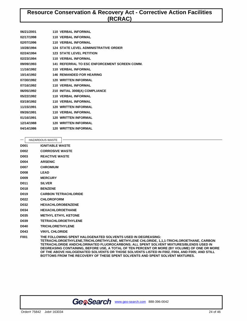
06/21/2001 110 VERBAL INFORMAL
02/17/1998 110 VERBAL INFORMAL
02/07/1996 110 VERBAL INFORMAL
10/28/1994 124 STATE LEVEL ADMINISTRATIVE ORDER
02/24/1994 123 STATE LEVEL PETITION
02/23/1994 110 VERBAL INFORMAL
09/09/1993 141 REFERRAL TO ESC ENFORCEMENT SCREEN COMM.
11/16/1992 110 VERBAL INFORMAL
10/14/1992 146 REMANDED FOR HEARING
07/30/1992 120 WRITTEN INFORMAL
07/16/1992 110 VERBAL INFORMAL
06/05/1992 210 INITIAL 3008(A) COMPLIANCE
05/22/1992 110 VERBAL INFORMAL
03/19/1992 110 VERBAL INFORMAL
11/15/1991 120 WRITTEN INFORMAL
09/26/1991 110 VERBAL INFORMAL
01/16/1991 120 WRITTEN INFORMAL
12/14/1988 120 WRITTEN INFORMAL
04/14/1986 120 WRITTEN INFORMAL
HAZARDOUS WASTE
D001 IGNITABLE WASTE
D002 CORROSIVE WASTE
D003 REACTIVE WASTE
D004 ARSENIC
D007 CHROMIUM
D008 LEAD
D009 MERCURY
D011 SILVER
D018 BENZENE
D019 CARBON TETRACHLORIDE
D022 CHLOROFORM
D032 HEXACHLOROBENZENE
D034 HEXACHLOROETHANE
D035 METHYL ETHYL KETONE
D039 TETRACHLOROETHYLENE
D040 TRICHLORETHYLENE
D043 VINYL CHLORIDE
F001 THE FOLLOWING SPENT HALOGENATED SOLVENTS USED IN DEGREASING:TETRACHLOROETHYLENE,TRICHLORETHYLENE, METHYLENE CHLORIDE, 1,1,1-TRICHLOROETHANE, CARBONTETRACHLORIDE ANDCHLORINATED FLUOROCARBONS; ALL SPENT SOLVENT MIXTURES/BLENDS USED INDEGREASING CONTAINING, BEFORE USE, A TOTAL OF TEN PERCENT OR MORE (BY VOLUME) OF ONE OR MOREOF THE ABOVE HALOGENATED SOLVENTS OR THOSE SOLVENTS LISTED IN F002, F004, AND F005; AND STILLBOTTOMS FROM THE RECOVERY OF THESE SPENT SOLVENTS AND SPENT SOLVENT MIXTURES.
24 of 46
www.geo-search.com 888-396-0042
Order# 75842 Job# 163034
Target Property SummaryDatabase SummaryDatabase Radius SummaryLocated Sites SummaryElevation SummaryIndustrial and Hazardous Waste Corrective Action Sites (IHWCA)Resource Conservation & Recovery Act - Corrective Action Facilities(RCRAC)

F002 THE FOLLOWING SPENT HALOGENATED SOLVENTS: TETRACHLOROETHYLENE, METHYLENECHLORIDE,TRICHLOROETHYLENE, 1,1,1-TRICHLOROETHANE,CHLOROBENZENE, 1,1,2-TRICHLORO-1,2,2-TRIFLUOROETHANE, ORTHO-DICHLOROBENZENE, TRICHLOROFLUOROMETHANE, AND 1,1,2,TRICHLOROETHANE; ALL SPENT SOLVENT MIXTURES/BLENDS CONTAINING, BEFORE USE, A TOTAL OF TENPERCENT OR MORE (BY VOLUME) OF ONE OR MORE OF THE ABOVE HALOGENATED SOLVENTS OR THOSESOLVENTS LISTED IN F001,F004, AND F005; AND STILL BOTTOMS FROM THE RECOVERY OF THESE SPENTSOLVENTS AND SPENT SOLVENT MIXTURES.
F003 THE FOLLOWING SPENT NON-HALOGENATED SOLVENTS: XYLENE, ACETONE, ETHYL ACETATE, ETHYLBENZENE, ETHYL ETHER, METHYL ISOBUTYL KETONE, N-BUTYL ALCOHOL, CYCLOHEXANONE, AND METHANOL;ALL SPENT SOLVENT MIXTURES/BLENDS CONTAINING, BEFORE USE, ONLY THE ABOVE SPENTNONHALOGENATED SOLVENTS; AND ALL SPENT SOLVENT MIXTURES/BLENDS CONTAINING, BEFORE USE, ONEOR MORE OF THE ABOVE NONHALOGENATED SOLVENTS, AND A TOTAL OF TEN PERCENT OR MORE (BYVOLUME) OF ONE OR MORE OF THOSE SOLVENTS LISTED IN F001, F002, F004, AND F005; AND STILL BOTTOMSFROM THE RECOVERY OF THESE SPENT SOLVENTS AND SPENT SOLVENT MIXTURES.
F005 THE FOLLOWING SPENT NONHALOGENATED SOLVENTS: TOLUENE, METHYL ETHYL KETONE,CARBONDISULFIDE, ISOBUTANOL, PYRIDINE,BENZENE, 2-ETHOXYETHANOL, AND 2-NITROPROPANE; ALL SPENTSOLVENT MIXTURES/BLENDS CONTAINING, BEFORE USE, A TOTAL OF TEN PERCENT OR MORE (BY VOLUME) OFONE OR MORE OF THE ABOVE NONHALOGENATED SOLVENTS OR THOSE SOLVENTS LISTED IN F001,F002, ORF004; AND STILL BOTTOMS FROM THE RECOVERY OF THESE SPENT SOLVENTS AND SPENT SOLVENT MIXTURES.
F024 PROCESS WASTES INCLUDING, BUT NOT LIMITED TO, DISTILLATION RESIDUES, HEAVY ENDS, TARS, ANDREACTOR CLEAN-OUT WASTES, FROM THE PRODUCTION OF CERTAIN CHLORINATED ALIPHATICHYDROCARBONS BY FREE RADICAL CATALYZED PROCESSES. THESE CHLORINATED ALIPHATICHYDROCARBONS ARE THOSE HAVING CARBON CHAIN LENGTHS RANGING FROM ONE TO AND INCLUDING FIVE,WITH VARYING AMOUNTS AND POSITIONS OF CHLORINE SUBSTITUTION. (THIS LISTING DOES NOT INCLUDEWASTEWATERS, WASTEWATER TREATMENT SLUDGE, SPENT CATALYSTS, AND WASTES LISTED IN SECTIONS261.31. OR 261.32)
K016 HEAVY ENDS OR DISTILLATION RESIDUES FROM THE PRODUCTION OF CARBON TETRACHLORIDE.
P012 ARSENIC OXIDE AS2O3
P012 ARSENIC TRIOXIDE
U013
U019 BENZENE (I,T)
U044 CHLOROFORM
U044 METHANE, TRICHLORO-
U056 BENZENE, HEXAHYDRO- (I)
U056 CYCLOHEXANE (I)
U078 1,1-DICHLOROETHYLENE
U078 ETHENE, 1,1-DICHLORO-
U121 METHANE, TRICHLOROFLUORO-
U121 TRICHLOROMONOFLUOROMETHANE
U134 HYDROFLUORIC ACID (C,T)
U134 HYDROGEN FLUORIDE (C,T)
U151 MERCURY
U210 ETHENE, TETRACHLORO-
U211 CARBON TETRACHLORIDE
U211 METHANE, TETRACHLORO-
U229
UNIVERSAL WASTE
WASTE TYPE: ACCUMULATEDWASTE ON-SITE:
GENERATEDWASTE ON-SITE:
SOURCE TYPE:
BATTERIES NO NO ANNUAL/BIENNIAL REPORT
BATTERIES UNKNOWN UNKNOWN ANNUAL/BIENNIAL REPORT
LAMPS NO NO ANNUAL/BIENNIAL REPORT
25 of 46
www.geo-search.com 888-396-0042
Order# 75842 Job# 163034
Target Property SummaryDatabase SummaryDatabase Radius SummaryLocated Sites SummaryElevation SummaryIndustrial and Hazardous Waste Corrective Action Sites (IHWCA)Resource Conservation & Recovery Act - Corrective Action Facilities(RCRAC)
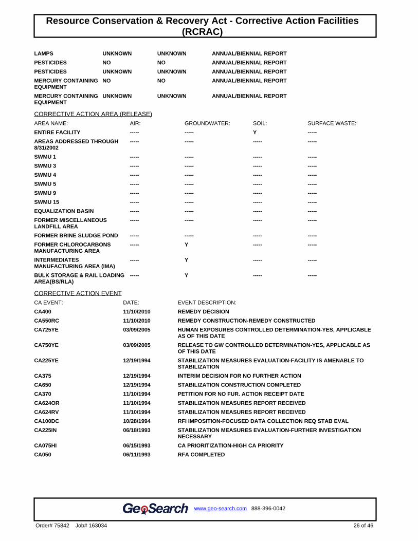
LAMPS UNKNOWN UNKNOWN ANNUAL/BIENNIAL REPORT
PESTICIDES NO NO ANNUAL/BIENNIAL REPORT
PESTICIDES UNKNOWN UNKNOWN ANNUAL/BIENNIAL REPORT
MERCURY CONTAININGEQUIPMENT
NO NO ANNUAL/BIENNIAL REPORT
MERCURY CONTAININGEQUIPMENT
UNKNOWN UNKNOWN ANNUAL/BIENNIAL REPORT
CORRECTIVE ACTION AREA (RELEASE)
AREA NAME: AIR: GROUNDWATER: SOIL: SURFACE WASTE:
ENTIRE FACILITY ----- ----- Y -----
AREAS ADDRESSED THROUGH8/31/2002
----- ----- ----- -----
SWMU 1 ----- ----- ----- -----
SWMU 3 ----- ----- ----- -----
SWMU 4 ----- ----- ----- -----
SWMU 5 ----- ----- ----- -----
SWMU 9 ----- ----- ----- -----
SWMU 15 ----- ----- ----- -----
EQUALIZATION BASIN ----- ----- ----- -----
FORMER MISCELLANEOUSLANDFILL AREA
----- ----- ----- -----
FORMER BRINE SLUDGE POND ----- ----- ----- -----
FORMER CHLOROCARBONSMANUFACTURING AREA
----- Y ----- -----
INTERMEDIATESMANUFACTURING AREA (IMA)
----- Y ----- -----
BULK STORAGE & RAIL LOADINGAREA(BS/RLA)
----- Y ----- -----
CORRECTIVE ACTION EVENT
CA EVENT: DATE: EVENT DESCRIPTION:
CA400 11/10/2010 REMEDY DECISION
CA550RC 11/10/2010 REMEDY CONSTRUCTION-REMEDY CONSTRUCTED
CA725YE 03/09/2005 HUMAN EXPOSURES CONTROLLED DETERMINATION-YES, APPLICABLEAS OF THIS DATE
CA750YE 03/09/2005 RELEASE TO GW CONTROLLED DETERMINATION-YES, APPLICABLE ASOF THIS DATE
CA225YE 12/19/1994 STABILIZATION MEASURES EVALUATION-FACILITY IS AMENABLE TOSTABILIZATION
CA375 12/19/1994 INTERIM DECISION FOR NO FURTHER ACTION
CA650 12/19/1994 STABILIZATION CONSTRUCTION COMPLETED
CA370 11/10/1994 PETITION FOR NO FUR. ACTION RECEIPT DATE
CA624OR 11/10/1994 STABILIZATION MEASURES REPORT RECEIVED
CA624RV 11/10/1994 STABILIZATION MEASURES REPORT RECEIVED
CA100DC 10/28/1994 RFI IMPOSITION-FOCUSED DATA COLLECTION REQ STAB EVAL
CA225IN 06/18/1993 STABILIZATION MEASURES EVALUATION-FURTHER INVESTIGATIONNECESSARY
CA075HI 06/15/1993 CA PRIORITIZATION-HIGH CA PRIORITY
CA050 06/11/1993 RFA COMPLETED
26 of 46
www.geo-search.com 888-396-0042
Order# 75842 Job# 163034
Target Property SummaryDatabase SummaryDatabase Radius SummaryLocated Sites SummaryElevation SummaryIndustrial and Hazardous Waste Corrective Action Sites (IHWCA)Resource Conservation & Recovery Act - Corrective Action Facilities(RCRAC)
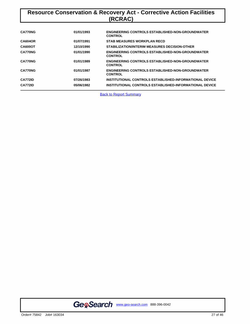
CA770NG 01/01/1993 ENGINEERING CONTROLS ESTABLISHED-NON-GROUNDWATERCONTROL
CA604OR 01/07/1991 STAB MEASURES WORKPLAN RECD
CA600OT 12/10/1990 STABILIZATION/INTERIM MEASURES DECISION-OTHER
CA770NG 01/01/1990 ENGINEERING CONTROLS ESTABLISHED-NON-GROUNDWATERCONTROL
CA770NG 01/01/1989 ENGINEERING CONTROLS ESTABLISHED-NON-GROUNDWATERCONTROL
CA770NG 01/01/1987 ENGINEERING CONTROLS ESTABLISHED-NON-GROUNDWATERCONTROL
CA772ID 07/26/1983 INSTITUTIONAL CONTROLS ESTABLISHED-INFORMATIONAL DEVICE
CA772ID 05/06/1982 INSTITUTIONAL CONTROLS ESTABLISHED-INFORMATIONAL DEVICE
Back to Report Summary
27 of 46
www.geo-search.com 888-396-0042
Order# 75842 Job# 163034
Target Property SummaryDatabase SummaryDatabase Radius SummaryLocated Sites SummaryElevation SummaryIndustrial and Hazardous Waste Corrective Action Sites (IHWCA)Resource Conservation & Recovery Act - Corrective Action Facilities(RCRAC)
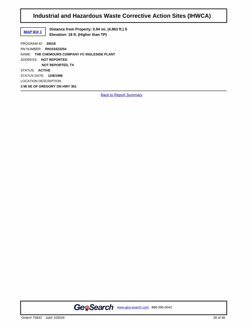
MAP ID# 1Distance from Property: 0.94 mi. (4,963 ft.) SElevation: 18 ft. (Higher than TP)
PROGRAM ID: 30018
RN NUMBER: RN101623254
NAME: THE CHEMOURS COMPANY FC INGLESIDE PLANT
ADDRESS: NOT REPORTED
NOT REPORTED, TX
STATUS: ACTIVE
STATUS DATE: 12/8/1998
LOCATION DESCRIPTION:
3 MI SE OF GREGORY ON HWY 361
Back to Report Summary
28 of 46
www.geo-search.com 888-396-0042
Order# 75842 Job# 163034
Target Property SummaryDatabase SummaryDatabase Radius SummaryLocated Sites SummaryElevation SummaryIndustrial and Hazardous Waste Corrective Action Sites (IHWCA)Resource Conservation & Recovery Act - Corrective Action Facilities(RCRAC)Industrial and Hazardous Waste Corrective Action Sites (IHWCA)
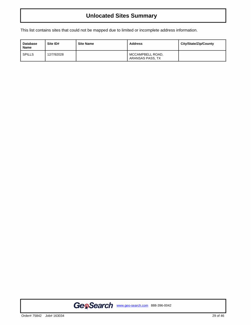
This list contains sites that could not be mapped due to limited or incomplete address information.
DatabaseName
Site ID# Site Name Address City/State/Zip/County
SPILLS 12/7/92028 MCCAMPBELL ROAD,ARANSAS PASS, TX
29 of 46
www.geo-search.com 888-396-0042
Order# 75842 Job# 163034
Target Property SummaryDatabase SummaryDatabase Radius SummaryLocated Sites SummaryElevation SummaryIndustrial and Hazardous Waste Corrective Action Sites (IHWCA)Resource Conservation & Recovery Act - Corrective Action Facilities(RCRAC)Industrial and Hazardous Waste Corrective Action Sites (IHWCA)Unlocated Sites Summary
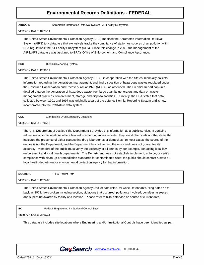
AIRSAFS Aerometric Information Retrieval System / Air Facility Subsystem
VERSION DATE: 10/20/14
The United States Environmental Protection Agency (EPA) modified the Aerometric Information Retrieval
System (AIRS) to a database that exclusively tracks the compliance of stationary sources of air pollution with
EPA regulations: the Air Facility Subsystem (AFS). Since this change in 2001, the management of the
AIRS/AFS database was assigned to EPA's Office of Enforcement and Compliance Assurance.
BRS Biennial Reporting System
VERSION DATE: 12/31/11
The United States Environmental Protection Agency (EPA), in cooperation with the States, biennially collects
information regarding the generation, management, and final disposition of hazardous wastes regulated under
the Resource Conservation and Recovery Act of 1976 (RCRA), as amended. The Biennial Report captures
detailed data on the generation of hazardous waste from large quantity generators and data on waste
management practices from treatment, storage and disposal facilities. Currently, the EPA states that data
collected between 1991 and 1997 was originally a part of the defunct Biennial Reporting System and is now
incorporated into the RCRAInfo data system.
CDL Clandestine Drug Laboratory Locations
VERSION DATE: 07/01/16
The U.S. Department of Justice ("the Department") provides this information as a public service. It contains
addresses of some locations where law enforcement agencies reported they found chemicals or other items that
indicated the presence of either clandestine drug laboratories or dumpsites. In most cases, the source of the
entries is not the Department, and the Department has not verified the entry and does not guarantee its
accuracy. Members of the public must verify the accuracy of all entries by, for example, contacting local law
enforcement and local health departments. The Department does not establish, implement, enforce, or certify
compliance with clean-up or remediation standards for contaminated sites; the public should contact a state or
local health department or environmental protection agency for that information.
DOCKETS EPA Docket Data
VERSION DATE: 12/22/05
The United States Environmental Protection Agency Docket data lists Civil Case Defendants, filing dates as far
back as 1971, laws broken including section, violations that occurred, pollutants involved, penalties assessed
and superfund awards by facility and location. Please refer to ICIS database as source of current data.
EC Federal Engineering Institutional Control Sites
VERSION DATE: 08/03/15
This database includes site locations where Engineering and/or Institutional Controls have been identified as part
30 of 46
www.geo-search.com 888-396-0042
Order# 75842 Job# 163034
Target Property SummaryDatabase SummaryDatabase Radius SummaryLocated Sites SummaryElevation SummaryIndustrial and Hazardous Waste Corrective Action Sites (IHWCA)Resource Conservation & Recovery Act - Corrective Action Facilities(RCRAC)Industrial and Hazardous Waste Corrective Action Sites (IHWCA)Unlocated Sites SummaryEnvironmental Records Definitions - FEDERAL
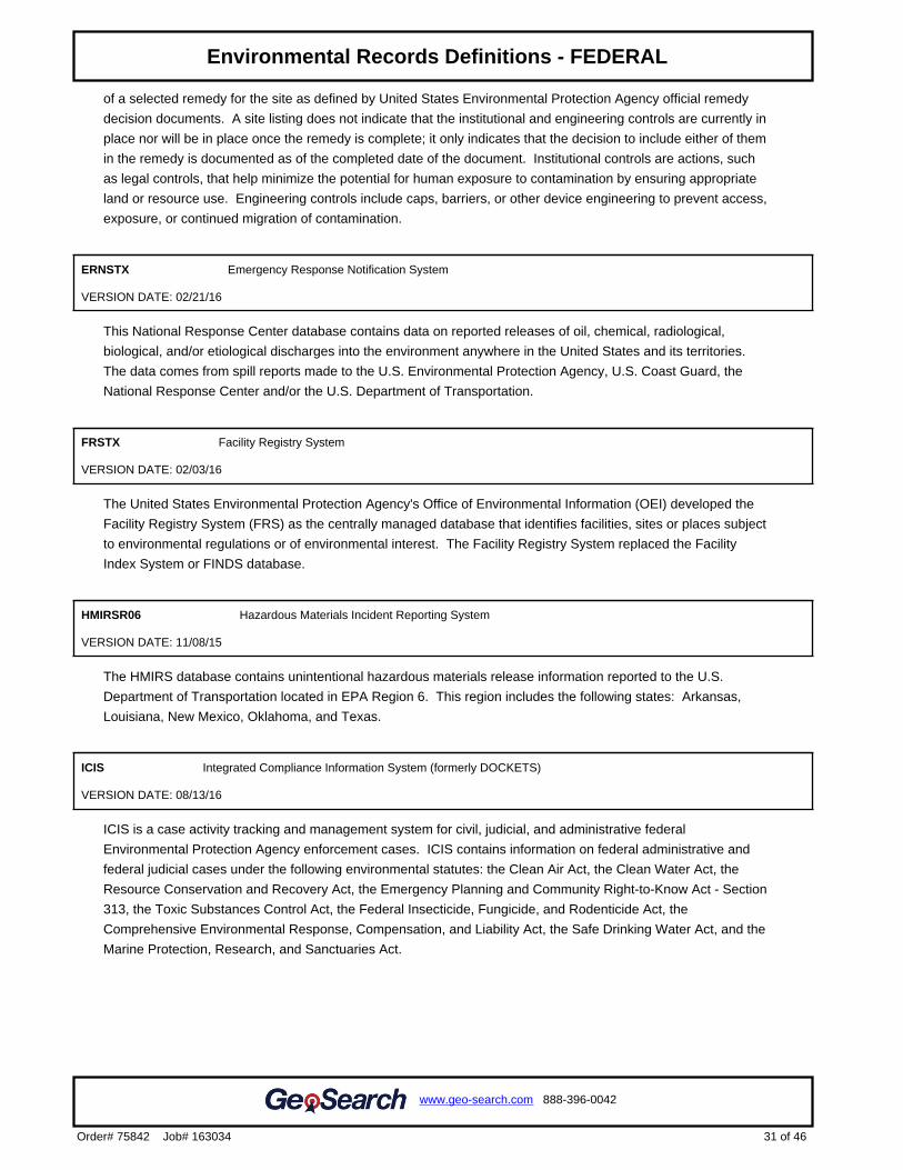
of a selected remedy for the site as defined by United States Environmental Protection Agency official remedy
decision documents. A site listing does not indicate that the institutional and engineering controls are currently in
place nor will be in place once the remedy is complete; it only indicates that the decision to include either of them
in the remedy is documented as of the completed date of the document. Institutional controls are actions, such
as legal controls, that help minimize the potential for human exposure to contamination by ensuring appropriate
land or resource use. Engineering controls include caps, barriers, or other device engineering to prevent access,
exposure, or continued migration of contamination.
ERNSTX Emergency Response Notification System
VERSION DATE: 02/21/16
This National Response Center database contains data on reported releases of oil, chemical, radiological,
biological, and/or etiological discharges into the environment anywhere in the United States and its territories.
The data comes from spill reports made to the U.S. Environmental Protection Agency, U.S. Coast Guard, the
National Response Center and/or the U.S. Department of Transportation.
FRSTX Facility Registry System
VERSION DATE: 02/03/16
The United States Environmental Protection Agency's Office of Environmental Information (OEI) developed the
Facility Registry System (FRS) as the centrally managed database that identifies facilities, sites or places subject
to environmental regulations or of environmental interest. The Facility Registry System replaced the Facility
Index System or FINDS database.
HMIRSR06 Hazardous Materials Incident Reporting System
VERSION DATE: 11/08/15
The HMIRS database contains unintentional hazardous materials release information reported to the U.S.
Department of Transportation located in EPA Region 6. This region includes the following states: Arkansas,
Louisiana, New Mexico, Oklahoma, and Texas.
ICIS Integrated Compliance Information System (formerly DOCKETS)
VERSION DATE: 08/13/16
ICIS is a case activity tracking and management system for civil, judicial, and administrative federal
Environmental Protection Agency enforcement cases. ICIS contains information on federal administrative and
federal judicial cases under the following environmental statutes: the Clean Air Act, the Clean Water Act, the
Resource Conservation and Recovery Act, the Emergency Planning and Community Right-to-Know Act - Section
313, the Toxic Substances Control Act, the Federal Insecticide, Fungicide, and Rodenticide Act, the
Comprehensive Environmental Response, Compensation, and Liability Act, the Safe Drinking Water Act, and the
Marine Protection, Research, and Sanctuaries Act.
31 of 46
www.geo-search.com 888-396-0042
Order# 75842 Job# 163034
Target Property SummaryDatabase SummaryDatabase Radius SummaryLocated Sites SummaryElevation SummaryIndustrial and Hazardous Waste Corrective Action Sites (IHWCA)Resource Conservation & Recovery Act - Corrective Action Facilities(RCRAC)Industrial and Hazardous Waste Corrective Action Sites (IHWCA)Unlocated Sites SummaryEnvironmental Records Definitions - FEDERAL
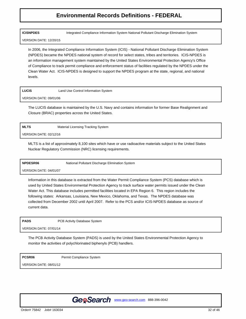
ICISNPDES Integrated Compliance Information System National Pollutant Discharge Elimination System
VERSION DATE: 12/20/15
In 2006, the Integrated Compliance Information System (ICIS) - National Pollutant Discharge Elimination System
(NPDES) became the NPDES national system of record for select states, tribes and territories. ICIS-NPDES is
an information management system maintained by the United States Environmental Protection Agency's Office
of Compliance to track permit compliance and enforcement status of facilities regulated by the NPDES under the
Clean Water Act. ICIS-NPDES is designed to support the NPDES program at the state, regional, and national
levels.
LUCIS Land Use Control Information System
VERSION DATE: 09/01/06
The LUCIS database is maintained by the U.S. Navy and contains information for former Base Realignment and
Closure (BRAC) properties across the United States.
MLTS Material Licensing Tracking System
VERSION DATE: 02/12/16
MLTS is a list of approximately 8,100 sites which have or use radioactive materials subject to the United States
Nuclear Regulatory Commission (NRC) licensing requirements.
NPDESR06 National Pollutant Discharge Elimination System
VERSION DATE: 04/01/07
Information in this database is extracted from the Water Permit Compliance System (PCS) database which is
used by United States Environmental Protection Agency to track surface water permits issued under the Clean
Water Act. This database includes permitted facilities located in EPA Region 6. This region includes the
following states: Arkansas, Louisiana, New Mexico, Oklahoma, and Texas. The NPDES database was
collected from December 2002 until April 2007. Refer to the PCS and/or ICIS-NPDES database as source of
current data.
PADS PCB Activity Database System
VERSION DATE: 07/01/14
The PCB Activity Database System (PADS) is used by the United States Environmental Protection Agency to
monitor the activities of polychlorinated biphenyls (PCB) handlers.
PCSR06 Permit Compliance System
VERSION DATE: 08/01/12
32 of 46
www.geo-search.com 888-396-0042
Order# 75842 Job# 163034
Target Property SummaryDatabase SummaryDatabase Radius SummaryLocated Sites SummaryElevation SummaryIndustrial and Hazardous Waste Corrective Action Sites (IHWCA)Resource Conservation & Recovery Act - Corrective Action Facilities(RCRAC)Industrial and Hazardous Waste Corrective Action Sites (IHWCA)Unlocated Sites SummaryEnvironmental Records Definitions - FEDERAL
The Permit Compliance System is used in tracking enforcement status and permit compliance of facilities
controlled by the National Pollutant Discharge Elimination System (NPDES) under the Clean Water Act and is
maintained by the United States Environmental Protection Agency's Office of Compliance. PCS is designed to
support the NPDES program at the state, regional, and national levels. This database includes permitted
facilities located in EPA Region 6. This region includes the following states: Arkansas, Louisiana, New Mexico,
Oklahoma, and Texas. PCS has been modernized, and no longer exists. National Pollutant Discharge
Elimination System (ICIS-NPDES) data can now be found in Integrated Compliance Information System (ICIS).
RCRASC RCRA Sites with Controls
VERSION DATE: 02/23/16
This list of Resource Conservation and Recovery Act sites with institutional controls in place is provided by the
U.S. Environmental Protection Agency.
SFLIENS CERCLIS Liens
VERSION DATE: 06/08/12
A Federal CERCLA ("Superfund") lien can exist by operation of law at any site or property at which United States
Environmental Protection Agency has spent Superfund monies. These monies are spent to investigate and
address releases and threatened releases of contamination. CERCLIS provides information as to the identity of
these sites and properties. This database contains those CERCLIS sites where the Lien on Property action is
complete.
SSTS Section Seven Tracking System
VERSION DATE: 12/08/14
The United States Environmental Protection Agency tracks information on pesticide establishments through the
Section Seven Tracking System (SSTS). SSTS records the registration of new establishments and records
pesticide production at each establishment. The Federal Insecticide, Fungicide and Rodenticide Act (FIFRA)
requires that production of pesticides or devices be conducted in a registered pesticide-producing or device-
producing establishment. ("Production" includes formulation, packaging, repackaging, and relabeling.)
TRI Toxics Release Inventory
VERSION DATE: 12/31/14
The Toxics Release Inventory, provided by the United States Environmental Protection Agency, includes data on
toxic chemical releases and waste management activities from certain industries as well as federal and tribal
facilities. This inventory contains information about the types and amounts of toxic chemicals that are released
each year to the air, water, and land as well as information on the quantities of toxic chemicals sent to other
facilities for further waste management.
33 of 46
www.geo-search.com 888-396-0042
Order# 75842 Job# 163034
Target Property SummaryDatabase SummaryDatabase Radius SummaryLocated Sites SummaryElevation SummaryIndustrial and Hazardous Waste Corrective Action Sites (IHWCA)Resource Conservation & Recovery Act - Corrective Action Facilities(RCRAC)Industrial and Hazardous Waste Corrective Action Sites (IHWCA)Unlocated Sites SummaryEnvironmental Records Definitions - FEDERAL
TSCA Toxic Substance Control Act Inventory
VERSION DATE: 12/31/06
The Toxic Substances Control Act (TSCA) was enacted in 1976 to ensure that chemicals manufactured,
imported, processed, or distributed in commerce, or used or disposed of in the United States do not pose any
unreasonable risks to human health or the environment. TSCA section 8(b) provides the United States
Environmental Protection Agency authority to "compile, keep current, and publish a list of each chemical
substance that is manufactured or processed in the United States." This TSCA Chemical Substance Inventory
contains non-confidential information on the production amount of toxic chemicals from each manufacturer and
importer site.
NLRRCRAG No Longer Regulated RCRA Generator Facilities
VERSION DATE: 07/12/16
This database includes RCRA Generator facilities that are no longer regulated by the United States
Environmental Protection Agency or do not meet other RCRA reporting requirements. This listing includes
facilities that formerly generated hazardous waste.
Large Quantity Generators: Generate 1,000 kg or more of hazardous waste during any calendar month; or
Generate more than 1 kg of acutely hazardous waste during any calendar month; or Generate more than 100 kg
of any residue or contaminated soil, waste or other debris resulting from the cleanup of a spill, into or on any land
or water, or acutely hazardous waste during any calendar month; or Generate 1 kg or less of acutely hazardous
waste during any calendar month, and accumulate more than 1kg of acutely hazardous waste at any time; or
Generate 100 kg or less of any residue or contaminated soil, waste or other debris resulting from the cleanup of
a spill, into or on any land or water, of acutely hazardous waste during any calendar month, and accumulated
more than 100 kg of that material at any time.
Small Quantity Generators: Generate more than 100 and less than 1000 kilograms of hazardous waste during
any calendar month and accumulate less than 6000 kg of hazardous waste at any time; or Generate 100 kg or
less of hazardous waste during any calendar month, and accumulate more than 1000 kg of hazardous waste at
any time.
Conditionally Exempt Small Quantity Generators: Generate 100 kilograms or less of hazardous waste per
calendar month, and accumulate 1000 kg or less of hazardous waste at any time; or Generate one kilogram or
less of acutely hazardous waste per calendar month, and accumulate at any time: 1 kg or less of acutely
hazardous waste; or 100 kg or less of any residue or contaminated soil, waste or other debris resulting from the
cleanup of a spill, into or on any land or water, or acutely hazardous waste; or Generate 100 kg or less of any
residue or contaminated soil, waste or other debris resulting from the cleanup of a spill, into or on any land or
water, or acutely hazardous waste during any calendar month, and accumulate at any time: 1 kg or less of
acutely hazardous waste; or 100 kg or less of any residue or contaminated soil, waste or other debris resulting
from the cleanup of a spill, into or on any land or water, of acutely hazardous waste.
RCRAGR06 Resource Conservation & Recovery Act - Generator
VERSION DATE: 07/12/16
This database includes sites listed as generators of hazardous waste (large, small, and exempt) in the RCRAInfo
34 of 46
www.geo-search.com 888-396-0042
Order# 75842 Job# 163034
Target Property SummaryDatabase SummaryDatabase Radius SummaryLocated Sites SummaryElevation SummaryIndustrial and Hazardous Waste Corrective Action Sites (IHWCA)Resource Conservation & Recovery Act - Corrective Action Facilities(RCRAC)Industrial and Hazardous Waste Corrective Action Sites (IHWCA)Unlocated Sites SummaryEnvironmental Records Definitions - FEDERAL
system. The United States Environmental Protection Agency defines RCRAInfo as the comprehensive
information system which provides access to data supporting the Resource Conservation and Recovery Act
(RCRA) of 1976 and the Hazardous and Solid Waste Amendments (HSWA) of 1984. RCRAInfo replaces the
data recording and reporting abilities of the Resource Conservation and Recovery Information System (RCRIS)
and the Biennial Reporting System (BRS). This database includes sites located in EPA Region 6. This region
includes the following states: Arkansas, Louisiana, New Mexico, Oklahoma, and Texas.
Large Quantity Generators: Generate 1,000 kg or more of hazardous waste during any calendar month; or
Generate more than 1 kg of acutely hazardous waste during any calendar month; or Generate more than 100 kg
of any residue or contaminated soil, waste or other debris resulting from the cleanup of a spill, into or on any land
or water, or acutely hazardous waste during any calendar month; or Generate 1 kg or less of acutely hazardous
waste during any calendar month, and accumulate more than 1kg of acutely hazardous waste at any time; or
Generate 100 kg or less of any residue or contaminated soil, waste or other debris resulting from the cleanup of
a spill, into or on any land or water, of acutely hazardous waste during any calendar month, and accumulated
more than 100 kg of that material at any time.
Small Quantity Generators: Generate more than 100 and less than 1000 kilograms of hazardous waste during
any calendar month and accumulate less than 6000 kg of hazardous waste at any time; or Generate 100 kg or
less of hazardous waste during any calendar month, and accumulate more than 1000 kg of hazardous waste at
any time.
Conditionally Exempt Small Quantity Generators: Generate 100 kilograms or less of hazardous waste per
calendar month, and accumulate 1000 kg or less of hazardous waste at any time; or Generate one kilogram or
less of acutely hazardous waste per calendar month, and accumulate at any time: 1 kg or less of acutely
hazardous waste; or 100 kg or less of any residue or contaminated soil, waste or other debris resulting from the
cleanup of a spill, into or on any land or water, or acutely hazardous waste; or Generate 100 kg or less of any
residue or contaminated soil, waste or other debris resulting from the cleanup of a spill, into or on any land or
water, or acutely hazardous waste during any calendar month, and accumulate at any time: 1 kg or less of
acutely hazardous waste; or 100 kg or less of any residue or contaminated soil, waste or other debris resulting
from the cleanup of a spill, into or on any land or water, of acutely hazardous waste.
RCRANGR06 Resource Conservation & Recovery Act - Non-Generator
VERSION DATE: 07/12/16
This database identifies RCRAInfo system sites that only handle hazardous waste, such as transporters, without
generating any amount hazardous waste. The United States Environmental Protection Agency defines
RCRAInfo as the comprehensive information system which provides access to data supporting the Resource
Conservation and Recovery Act (RCRA) of 1976 and the Hazardous and Solid Waste Amendments (HSWA) of
1984. RCRAInfo replaces the data recording and reporting abilities of the Resource Conservation and Recovery
Information System (RCRIS) and the Biennial Reporting System (BRS). This database includes sites located in
EPA Region 6. This region includes the following states: Arkansas, Louisiana, New Mexico, Oklahoma, and
Texas.
HISTPST Historical Gas Stations
VERSION DATE: NR
This historic directory of service stations is provided by the Cities Service Company. The directory includes
35 of 46
www.geo-search.com 888-396-0042
Order# 75842 Job# 163034
Target Property SummaryDatabase SummaryDatabase Radius SummaryLocated Sites SummaryElevation SummaryIndustrial and Hazardous Waste Corrective Action Sites (IHWCA)Resource Conservation & Recovery Act - Corrective Action Facilities(RCRAC)Industrial and Hazardous Waste Corrective Action Sites (IHWCA)Unlocated Sites SummaryEnvironmental Records Definitions - FEDERAL
Cities Service filling stations that were located throughout the United States in 1930.
MSHA Mine Safety and Health Administration Master Index File
VERSION DATE: 08/05/16
The Mine dataset lists all Coal and Metal/Non-Metal mines under MSHA's jurisdiction since 1/1/1970. It includes
such information as the current status of each mine (Active, Abandoned, NonProducing, etc.), the current owner
and operating company, commodity codes and physical attributes of the mine. Mine ID is the unique key for this
data. This information is provided by the United States Department of Labor - Mine Safety and Health
Administration (MSHA).
BF Brownfields Management System
VERSION DATE: 07/15/16
Brownfields are real property, the expansion, redevelopment, or reuse of which may be complicated by the
presence or potential presence of a hazardous substance, pollutant, or contaminant. Cleaning up and reinvesting
in these properties takes development pressures off of undeveloped, open land, and both improves and protects
the environment. The United States Environmental Protection Agency maintains this database to track activities
in the various brown field grant programs including grantee assessment, site cleanup and site redevelopment.
This database included tribal brownfield sites.
DNPL Delisted National Priorities List
VERSION DATE: 03/07/16
This database includes sites from the United States Environmental Protection Agency’s Final National Priorities
List (NPL) where remedies have proven to be satisfactory or sites where the original analyses were inaccurate,
and the site is no longer appropriate for inclusion on the NPL, and final publication in the Federal Register has
occurred.
NLRRCRAT No Longer Regulated RCRA Non-CORRACTS TSD Facilities
VERSION DATE: 07/12/16
This database includes RCRA Non-Corrective Action TSD facilities that are no longer regulated by the United
States Environmental Protection Agency or do not meet other RCRA reporting requirements. This listing
includes facilities that formerly treated, stored or disposed of hazardous waste.
ODI Open Dump Inventory
VERSION DATE: 06/01/85
The open dump inventory was published by the United States Environmental Protection Agency. An “open dump”
is defined as a facility or site where solid waste is disposed of which is not a sanitary landfill which meets the
criteria promulgated under section 4004 of the Solid Waste Disposal Act (42 U.S.C. 6944) and which is not a
36 of 46
www.geo-search.com 888-396-0042
Order# 75842 Job# 163034
Target Property SummaryDatabase SummaryDatabase Radius SummaryLocated Sites SummaryElevation SummaryIndustrial and Hazardous Waste Corrective Action Sites (IHWCA)Resource Conservation & Recovery Act - Corrective Action Facilities(RCRAC)Industrial and Hazardous Waste Corrective Action Sites (IHWCA)Unlocated Sites SummaryEnvironmental Records Definitions - FEDERAL

facility for disposal of hazardous waste. This inventory has not been updated since June 1985.
RCRAT Resource Conservation & Recovery Act - Non-CORRACTS Treatment, Storage & Disposal Facilities
VERSION DATE: 07/12/16
This database includes Non-Corrective Action sites listed as treatment, storage and/or disposal facilities of
hazardous waste in the RCRAInfo system. The United States Environmental Protection Agency defines
RCRAInfo as the comprehensive information system which provides access to data supporting the Resource
Conservation and Recovery Act (RCRA) of 1976 and the Hazardous and Solid Waste Amendments (HSWA) of
1984. RCRAInfo replaces the data recording and reporting abilities of the Resource Conservation and Recovery
Information System (RCRIS) and the Biennial Reporting System (BRS).
SEMS Superfund Enterprise Management System
VERSION DATE: 03/07/16
The U.S. Environmental Protections Agency's (EPA) Office of Solid Waste and Emergency Response, Office of
Superfund Remediation and Technology Innovation (OSRTI), has implemented The Superfund Enterprise
Management System (SEMS), formerly known as CERCLIS (Comprehensive Environmental Response,
Compensation and Liability Information System) to track and report on clean-up and enforcement activities
taking place at Superfund sites. SEMS represents a joint development and ongoing collaboration between
Superfund's Remedial, Removal, Federal Facilities, Enforcement and Emergency Response programs.
SEMSARCH Superfund Enterprise Management System Archived Site Inventory
VERSION DATE: 03/16/16
The Superfund Enterprise Management System Archive listing (SEMS-ARCHIVE) has replaced the CERCLIS
NFRAP reporting system in 2015. This listing reflect sites that have been assessed and no further remediation is
planned and is of no further interest under the Superfund program.
DOD Department of Defense Sites
VERSION DATE: 06/21/10
This information originates from the National Atlas of the United States Federal Lands data, which includes lands
owned or administered by the Federal government. Army DOD, Army Corps of Engineers DOD, Air Force DOD,
Navy DOD and Marine DOD areas of 640 acres or more are included.
FUDS Formerly Used Defense Sites
VERSION DATE: 06/01/15
The Formerly Used Defense Sites (FUDS) inventory includes properties previously owned by or leased to the
United States and under Secretary of Defense Jurisdiction, as well as Munitions Response Areas (MRAs). The
remediation of these properties is the responsibility of the Department of Defense. This data is provided by the
37 of 46
www.geo-search.com 888-396-0042
Order# 75842 Job# 163034
Target Property SummaryDatabase SummaryDatabase Radius SummaryLocated Sites SummaryElevation SummaryIndustrial and Hazardous Waste Corrective Action Sites (IHWCA)Resource Conservation & Recovery Act - Corrective Action Facilities(RCRAC)Industrial and Hazardous Waste Corrective Action Sites (IHWCA)Unlocated Sites SummaryEnvironmental Records Definitions - FEDERAL

U.S. Army Corps of Engineers (USACE), the boundaries/polygon data are based on preliminary findings and not
all properties currently have polygon data available. DISCLAIMER: This data represents the results of data
collection/processing for a specific USACE activity and is in no way to be considered comprehensive or to be
used in any legal or official capacity as presented on this site. While the USACE has made a reasonable effort to
insure the accuracy of the maps and associated data, it should be explicitly noted that USACE makes no
warranty, representation or guaranty, either expressed or implied, as to the content, sequence, accuracy,
timeliness or completeness of any of the data provided herein. For additional information on Formerly Used
Defense Sites please contact the USACE Public Affairs Office at (202) 528-4285.
NLRRCRAC No Longer Regulated RCRA Corrective Action Facilities
VERSION DATE: 07/12/16
This database includes RCRA Corrective Action facilities that are no longer regulated by the United States
Environmental Protection Agency or do not meet other RCRA reporting requirements.
NPL National Priorities List
VERSION DATE: 03/07/16
This database includes United States Environmental Protection Agency (EPA) National Priorities List sites that
fall under the EPA's Superfund program, established to fund the cleanup of the most serious uncontrolled or
abandoned hazardous waste sites identified for possible long-term remedial action.
PNPL Proposed National Priorities List
VERSION DATE: 03/07/16
This database contains sites proposed to be included on the National Priorities List (NPL) in the Federal
Register. The United States Environmental Protection Agency investigates these sites to determine if they may
present long-term threats to public health or the environment.
RCRAC Resource Conservation & Recovery Act - Corrective Action Facilities
VERSION DATE: 07/12/16
This database includes all hazardous waste sites with ongoing corrective action activity and where corrective
action is statutorily required to be address but have not had corrective action imposed in the RCRAInfo system.
The Corrective Action Program requires owners or operators of RCRA facilities (or treatment, storage, and
disposal facilities) to investigate and cleanup contamination in order to protect human health and the
environment. The United States Environmental Protection Agency defines RCRAInfo as the comprehensive
information system which provides access to data supporting the Resource Conservation and Recovery Act
(RCRA) of 1976 and the Hazardous and Solid Waste Amendments (HSWA) of 1984. RCRAInfo replaces the
data recording and reporting abilities of the Resource Conservation and Recovery Information System (RCRIS)
and the Biennial Reporting System (BRS).
38 of 46
www.geo-search.com 888-396-0042
Order# 75842 Job# 163034
Target Property SummaryDatabase SummaryDatabase Radius SummaryLocated Sites SummaryElevation SummaryIndustrial and Hazardous Waste Corrective Action Sites (IHWCA)Resource Conservation & Recovery Act - Corrective Action Facilities(RCRAC)Industrial and Hazardous Waste Corrective Action Sites (IHWCA)Unlocated Sites SummaryEnvironmental Records Definitions - FEDERAL
RCRASUBC Resource Conservation & Recovery Act - Subject to Corrective Action Facilities
VERSION DATE: 07/12/16
This database includes hazardous waste sites which are potentially subject to corrective action regardless of
whether they have correction action underway, plus any sites showing a corrective action event of RFI or beyond
in the RCRAInfo system. Sites conducting corrective action under analogous state authorities are also included.
The United States Environmental Protection Agency defines RCRAInfo as the comprehensive information
system which provides access to data supporting the Resource Conservation and Recovery Act (RCRA) of 1976
and the Hazardous and Solid Waste Amendments (HSWA) of 1984. RCRAInfo replaces the data recording and
reporting abilities of the Resource Conservation and Recovery Information System (RCRIS) and the Biennial
Reporting System (BRS).
RODS Record of Decision System
VERSION DATE: 07/01/13
These decision documents maintained by the United States Environmental Protection Agency describe the
chosen remedy for NPL (Superfund) site remediation. They also include site history, site description, site
characteristics, community participation, enforcement activities, past and present activities, contaminated media,
the contaminants present, and scope and role of response action.
39 of 46
www.geo-search.com 888-396-0042
Order# 75842 Job# 163034
Target Property SummaryDatabase SummaryDatabase Radius SummaryLocated Sites SummaryElevation SummaryIndustrial and Hazardous Waste Corrective Action Sites (IHWCA)Resource Conservation & Recovery Act - Corrective Action Facilities(RCRAC)Industrial and Hazardous Waste Corrective Action Sites (IHWCA)Unlocated Sites SummaryEnvironmental Records Definitions - FEDERAL
GWCC Groundwater Contamination Cases
VERSION DATE: 12/31/14
This report contains a listing of groundwater contamination cases which were documented for the 2013 calendar
year. Texas Water Code, Section 26.406 requires the annual report to describe the current status of
groundwater monitoring activities conducted or required by each agency at regulated facilities or associated with
regulated activities. The agencies reporting these contamination cases include the Texas Commission on
Environmental Quality, Railroad Commission of Texas, Texas Alliance of Groundwater Districts, and Department
of State Health Services.
HISTGWCC Historic Groundwater Contamination Cases
VERSION DATE: 12/31/12
This historic report contains all agency groundwater contamination cases documented from 1994 to 2012. The
agencies that reported these contamination cases included the Texas Commission on Environmental Quality,
Railroad Commission of Texas, Texas Alliance of Groundwater Districts, and Department of State Health
Services.
LIENS TCEQ Liens
VERSION DATE: 09/23/15
Liens filed upon State and/or Federal Superfund Sites by the Texas Commission on Environmental Quality.
MSD Municipal Setting Designations
VERSION DATE: 08/09/16
The Texas Commission on Environmental Quality defines an MSD as an official state designation given to
property within a municipality or its extraterritorial jurisdiction that certifies that designated groundwater at the
property is not used as potable water, and is prohibited from future use as potable water because that
groundwater is contaminated in excess of the applicable potable-water protective concentration level. The
prohibition must be in the form of a city ordinance, or a restrictive covenant that is enforceable by the city and
filed in the property records. The MSD property can be a single property, multi-property, or a portion of property.
NOV Notice of Violations
VERSION DATE: 02/24/16
This database containing Notice of Violations (NOV) is maintained by the Texas Commission on Environmental
Quality. An NOV is a written notification that documents and communicates violations observed during an
inspection to the business or individual inspected.
40 of 46
www.geo-search.com 888-396-0042
Order# 75842 Job# 163034
Target Property SummaryDatabase SummaryDatabase Radius SummaryLocated Sites SummaryElevation SummaryIndustrial and Hazardous Waste Corrective Action Sites (IHWCA)Resource Conservation & Recovery Act - Corrective Action Facilities(RCRAC)Industrial and Hazardous Waste Corrective Action Sites (IHWCA)Unlocated Sites SummaryEnvironmental Records Definitions - FEDERALEnvironmental Records Definitions - STATE (TX)
SIEC01 State Institutional/Engineering Control Sites
VERSION DATE: 09/14/16
The Texas Risk Reduction Program (TRRP) requires the placement of institutional controls (e.g., deed notices or
restrictive covenants) on affected property in different circumstances as part of completing a response action. In
its simplest form, an institutional control (IC) is a legal document that is recorded in the county deed records. In
certain circumstances, local zoning or ordinances can serve as an IC. This listing may also include locations
where Engineering Controls are in effect, such as a cap, barrier, or other engineering device to prevent access,
exposure, or continued migration of contamination. The sites included on this list are regulated by various
programs of the Texas Commission on Environmental Quality (TCEQ).
SPILLS Spills Listing
VERSION DATE: 02/16/16
This Texas Commission on Environmental Quality database includes releases of hazardous or potentially
hazardous materials into the environment.
TIERII Tier I I Chemical Reporting Program Facilities
VERSION DATE: 12/31/12
The Texas Tier II Chemical Reporting Program in the Department of State Health Services (DSHS) is the state
repository for EPCRA-required Emergency Planning Letters (EPLs), which are one-time notifications to the state
from facilities that have certain extremely hazardous chemicals in specified amounts. The Program is also the
state repository for EPCRA/state-required hazardous chemical inventory reports called Texas Tier Two Reports.
This data contains those facility reports for the 2005 through the 2012 calendar years.
DCR Dry Cleaner Registration Database
VERSION DATE: 07/14/16
The database includes dry cleaning drop stations and facilities registered with the Texas Commission on
Environmental Quality.
IHW Industrial and Hazardous Waste Sites
VERSION DATE: 04/01/16
Owner and facility information is included in this database of permitted and non-permitted industrial and
hazardous waste sites. Industrial waste is waste that results from or is incidental to operations of industry,
manufacturing, mining, or agriculture. Hazardous waste is defined as any solid waste listed as hazardous or
possesses one or more hazardous characteristics as defined in federal waste regulations. The IHW database is
maintained by the Texas Commission on Environmental Quality.
41 of 46
www.geo-search.com 888-396-0042
Order# 75842 Job# 163034
Target Property SummaryDatabase SummaryDatabase Radius SummaryLocated Sites SummaryElevation SummaryIndustrial and Hazardous Waste Corrective Action Sites (IHWCA)Resource Conservation & Recovery Act - Corrective Action Facilities(RCRAC)Industrial and Hazardous Waste Corrective Action Sites (IHWCA)Unlocated Sites SummaryEnvironmental Records Definitions - FEDERALEnvironmental Records Definitions - STATE (TX)
PIHW Permitted Industrial Hazardous Waste Sites
VERSION DATE: 04/01/16
Owner and facility information is included in this database of all permitted industrial and hazardous waste sites.
Industrial waste is waste that results from or is incidental to operations of industry, manufacturing, mining, or
agriculture. Hazardous waste is defined as any solid waste listed as hazardous or possesses one or more
hazardous characteristics as defined in federal waste regulations. Permitted IHW facilities are regulated under
30 Texas Administrative Code Chapter 335 in addition to federal regulations. The IHW database is maintained
by the Texas Commission on Environmental Quality.
PST Petroleum Storage Tanks
VERSION DATE: 07/07/16
The Petroleum Storage Tank database is administered by the Texas Commission on Environmental Quality
(TCEQ). Both Underground storage tanks (USTs) and Aboveground storage tanks (ASTs) are included in this
report. Petroleum Storage Tank registration has been a requirement with the TCEQ since 1986.
APAR Affected Property Assessment Reports
VERSION DATE: 02/02/16
As regulated by the Texas Commission on Environmental Quality, an Affected Property Assessment Report is
required when a person is addressing a release of chemical of concern (COC) under 30 TAC Chapter 350, the
Texas Risk Reduction Program (TRRP). The purpose of the APAR is to document all relevant affected property
information to identify all release sources and COCs, determine the extent of all COCs, identify all
transport/exposure pathways, and to determine if any response actions are necessary. The Texas
Administrative Code Title 30 §350.4(a)(1) defines affected property as the entire area (i.e. on-site and off-site;
including all environmental media) which contains releases of chemicals of concern at concentrations equal to or
greater than the assessment level applicable for residential land use and groundwater classification.
BSA Brownfields Site Assessments
VERSION DATE: 09/14/16
The Brownfields Site Assessments database is maintained by the Texas Commission on Environmental Quality
(TCEQ). The TCEQ, in close partnership with the U.S. Environmental Protection Agency (EPA) and other
federal, state, and local redevelopment agencies, and stakeholders, is facilitating cleanup, transferability, and
revitalization of brownfields through the development of regulatory, tax, and technical assistance tools.
CALF Closed & Abandoned Landfill Inventory
VERSION DATE: 11/01/05
The Texas Commission on Environmental Quality, under a contract with Texas State University, and in
cooperation with the 24 regional Council of Governments (COGs) in the State, has located over 4,000 closed
42 of 46
www.geo-search.com 888-396-0042
Order# 75842 Job# 163034
Target Property SummaryDatabase SummaryDatabase Radius SummaryLocated Sites SummaryElevation SummaryIndustrial and Hazardous Waste Corrective Action Sites (IHWCA)Resource Conservation & Recovery Act - Corrective Action Facilities(RCRAC)Industrial and Hazardous Waste Corrective Action Sites (IHWCA)Unlocated Sites SummaryEnvironmental Records Definitions - FEDERALEnvironmental Records Definitions - STATE (TX)

and abandoned municipal solid waste landfills throughout Texas. This listing contains "unauthorized sites".
Unauthorized sites have no permit and are considered abandoned. The information available for each site
varies in detail and this historical information is not updated. Please refer to the specific regional COG for the
most current information.
DCRPS Dry Cleaner Remediation Program Sites
VERSION DATE: 03/01/16
This list of DCRP sites is provided by the Texas Commission on Environmental Quality (TCEQ). According to
the TCEQ, the Dry Cleaner Remediation Program (DCRP) establishes a prioritization list of dry cleaner sites and
administers the Dry Cleaning Remediation fund to assist with remediation of contamination caused by dry
cleaning solvents.
IOP Innocent Owner / Operator Database
VERSION DATE: 09/14/16
Texas Innocent Owner / Operator (IOP), created by House Bill 2776 of the 75th Legislature, provides a certificate
to an innocent owner or operator if their property is contaminated as a result of a release or migration of
contaminants from a source or sources not located on the property, and they did not cause or contribute to the
source or sources of contamination. The IOP database is maintained by the Texas Commission on
Environmental Quality.
LPST Leaking Petroleum Storage Tanks
VERSION DATE: 09/06/16
The Leaking Petroleum Storage Tank listing is derived from the Petroleum Storage Tank (PST) database and is
maintained by the Texas Commission on Environmental Quality. This listing includes aboveground and
underground storage tank facilities with reported leaks.
MSWLF Municipal Solid Waste Landfill Sites
VERSION DATE: 07/22/16
The municipal solid waste landfill database is provided by the Texas Commission on Environmental Quality.
This database includes active landfills and inactive landfills, where solid waste is treated or stored.
RRCVCP Railroad Commission VCP and Brownfield Sites
VERSION DATE: 05/13/16
According to the Railroad Commission of Texas, their Voluntary Cleanup Program (RRC-VCP) provides an
incentive to remediate Oil & Gas related pollution by participants as long as they did not cause or contribute to
the contamination. Applicants to the program receive a release of liability to the state in exchange for a
successful cleanup.
43 of 46
www.geo-search.com 888-396-0042
Order# 75842 Job# 163034
Target Property SummaryDatabase SummaryDatabase Radius SummaryLocated Sites SummaryElevation SummaryIndustrial and Hazardous Waste Corrective Action Sites (IHWCA)Resource Conservation & Recovery Act - Corrective Action Facilities(RCRAC)Industrial and Hazardous Waste Corrective Action Sites (IHWCA)Unlocated Sites SummaryEnvironmental Records Definitions - FEDERALEnvironmental Records Definitions - STATE (TX)
RWS Radioactive Waste Sites
VERSION DATE: 07/11/06
This Texas Commission on Environmental Quality database contains all sites in the State of Texas that have
been designated as Radioactive Waste sites.
VCP Voluntary Cleanup Program Sites
VERSION DATE: 09/14/16
The Texas Voluntary Cleanup Program (VCP) provides administrative, technical, and legal incentives to
encourage the cleanup of contaminated sites in Texas. Since all non-responsible parties, including future
lenders and landowners, receive protection from liability to the state of Texas for cleanup of sites under the VCP,
most of the constraints for completing real estate transactions at those sites are eliminated. As a result, many
unused or underused properties may be restored to economically productive or community beneficial uses. The
VCP database is maintained by the Texas Commission on Environmental Quality.
WMRF Recycling Facilities
VERSION DATE: 11/01/12
This listing of recycling facilities is provided by the Texas Commission on Environmental Quality’s Recycle Texas
Online service. The company information provided in this database is self-reported. Since recyclers post their
own information, a facility or company appearing on the list does not imply that it is in compliance with TCEQ
regulations or other applicable laws. This database is no longer maintained and includes the last compilation of
the program participants before the Recycle Texas Online program was closed.
IHWCA Industrial and Hazardous Waste Corrective Action Sites
VERSION DATE: 09/28/16
This database is provided by the Texas Commission on Environmental Quality (TCEQ). According to the TCEQ,
the mission of the industrial and hazardous waste corrective action program is to oversee the cleanup of sites
contaminated from industrial and municipal hazardous and industrial nonhazardous wastes. The goals of this
program are to: Ensure that sites are assessed and remediated to levels that protect human health and the
environment; Verify that waste management units or facilities are taken out of service and closed properly; and
to Facilitate revitalization of contaminated properties.
SF State Superfund Sites
VERSION DATE: 07/02/15
The state Superfund program mission is to remediate abandoned or inactive sites within the state that pose an
unacceptable risk to public health and safety or the environment, but which do not qualify for action under the
federal Superfund program (NPL - National Priority Listing). As required by the Texas Solid Waste Disposal Act,
Texas Health and Safety Code, Chapter 361, the Texas Commission on Environmental Quality identifies and
44 of 46
www.geo-search.com 888-396-0042
Order# 75842 Job# 163034
Target Property SummaryDatabase SummaryDatabase Radius SummaryLocated Sites SummaryElevation SummaryIndustrial and Hazardous Waste Corrective Action Sites (IHWCA)Resource Conservation & Recovery Act - Corrective Action Facilities(RCRAC)Industrial and Hazardous Waste Corrective Action Sites (IHWCA)Unlocated Sites SummaryEnvironmental Records Definitions - FEDERALEnvironmental Records Definitions - STATE (TX)
evaluates these facilities for inclusion on the state Superfund registry. This registry includes any recent
developments and the anticipated action for these sites.
45 of 46
www.geo-search.com 888-396-0042
Order# 75842 Job# 163034
Target Property SummaryDatabase SummaryDatabase Radius SummaryLocated Sites SummaryElevation SummaryIndustrial and Hazardous Waste Corrective Action Sites (IHWCA)Resource Conservation & Recovery Act - Corrective Action Facilities(RCRAC)Industrial and Hazardous Waste Corrective Action Sites (IHWCA)Unlocated Sites SummaryEnvironmental Records Definitions - FEDERALEnvironmental Records Definitions - STATE (TX)

USTR06 Underground Storage Tanks On Tribal Lands
VERSION DATE: 06/16/16
This database, provided by the United States Environmental Protection Agency (EPA), contains underground
storage tanks on Tribal lands located in EPA Region 6. This region includes the following states: Arkansas,
Louisiana, New Mexico, Oklahoma, and Texas.
LUSTR06 Leaking Underground Storage Tanks On Tribal Lands
VERSION DATE: 04/15/16
This database, provided by the United States Environmental Protection Agency (EPA), contains leaking
underground storage tanks on Tribal lands located in EPA Region 6. This region includes the following states:
Arkansas, Louisiana, New Mexico, Oklahoma, and Texas.
ODINDIAN Open Dump Inventory on Tribal Lands
VERSION DATE: 11/08/06
This Indian Health Service database contains information about facilities and sites on tribal lands where solid
waste is disposed of, which are not sanitary landfills or hazardous waste disposal facilities, and which meet the
criteria promulgated under section 4004 of the Solid Waste Disposal Act (42 U.S.C. 6944).
INDIANRES Indian Reservations
VERSION DATE: 01/01/00
The Department of Interior and Bureau of Indian Affairs maintains this database that includes American Indian
Reservations, off-reservation trust lands, public domain allotments, Alaska Native Regional Corporations and
Recognized State Reservations.
46 of 46
www.geo-search.com 888-396-0042
Order# 75842 Job# 163034
Target Property SummaryDatabase SummaryDatabase Radius SummaryLocated Sites SummaryElevation SummaryIndustrial and Hazardous Waste Corrective Action Sites (IHWCA)Resource Conservation & Recovery Act - Corrective Action Facilities(RCRAC)Industrial and Hazardous Waste Corrective Action Sites (IHWCA)Unlocated Sites SummaryEnvironmental Records Definitions - FEDERALEnvironmental Records Definitions - STATE (TX)Environmental Records Definitions - TRIBAL

EXHIBIT C
Aerial Photographs
Target Property:
Prepared For:
Historical Aerials Package
Gregory, San Patricio County, Texas 78374Price Ranch
Testengeer Inc
Job #: 163042Order #: 75842
Date: 10/11/2016
http://www.geo-search.net/QuickMap/index.htm?DataID=Standard0000163042Click on link above to access the map and satellite view of current property
Project #: 20109838
phone: 888-396-0042 · fax: 512-472-9967 · www.geo-search.com

TARGET PROPERTY SUMMARY
Gregory, San Patricio County, Texas 78374Price Ranch
*Target property is located in Radon Zone 3.Zone 3 areas have a predicted average indoor radon screening level less than 2 pCi/L(picocuries per liter).
County/Parish Covered:
Zipcode(s) Covered:
State(s) Covered:
San Patricio (TX)
Aransas Pass TX: 78336Portland TX: 78374
TX
Target Property Geometry:Area
Target Property Longitude(s)/Latitude(s):(-97.231516, 27.924463), (-97.231516, 27.924463), (-97.229901, 27.924482), (-97.230085, 27.916786),(-97.231920, 27.916830), (-97.231989, 27.914685), (-97.236249, 27.914600), (-97.236098, 27.910106),(-97.239660, 27.910000), (-97.240026, 27.919167), (-97.231753, 27.919443), (-97.231516, 27.924463),(-97.231516, 27.924463)
USGS Quadrangle: Aransas Pass, TX
Disclaimer - The information provided in this report was obtained from a variety of public sources. GeoSearch cannot ensure and makes nowarranty or representation as to the accuracy, reliability, quality, errors occurring from data conversion or the customer’s interpretation ofthis report. This report was made by GeoSearch for exclusive use by its clients only. Therefore, this report may not contain sufficientinformation for other purposes or parties. GeoSearch and its partners, employees, officers and independent contractors cannot be heldliable for actual, incidental, consequential, special or exemplary damages suffered by a customer resulting directly or indirectly from anyinformation provided by GeoSearch.
www.geo-search.com · phone: 888-396-0042 · fax: 512-472-9967

TOPOGRAPHIC MAP
JOB #: 163042 - 10/10/2016
SITE: PRICE RANCHSOURCE: USDADATE: 2014COUNTY: SAN PATRICIOSCALE: 1" = 1000'
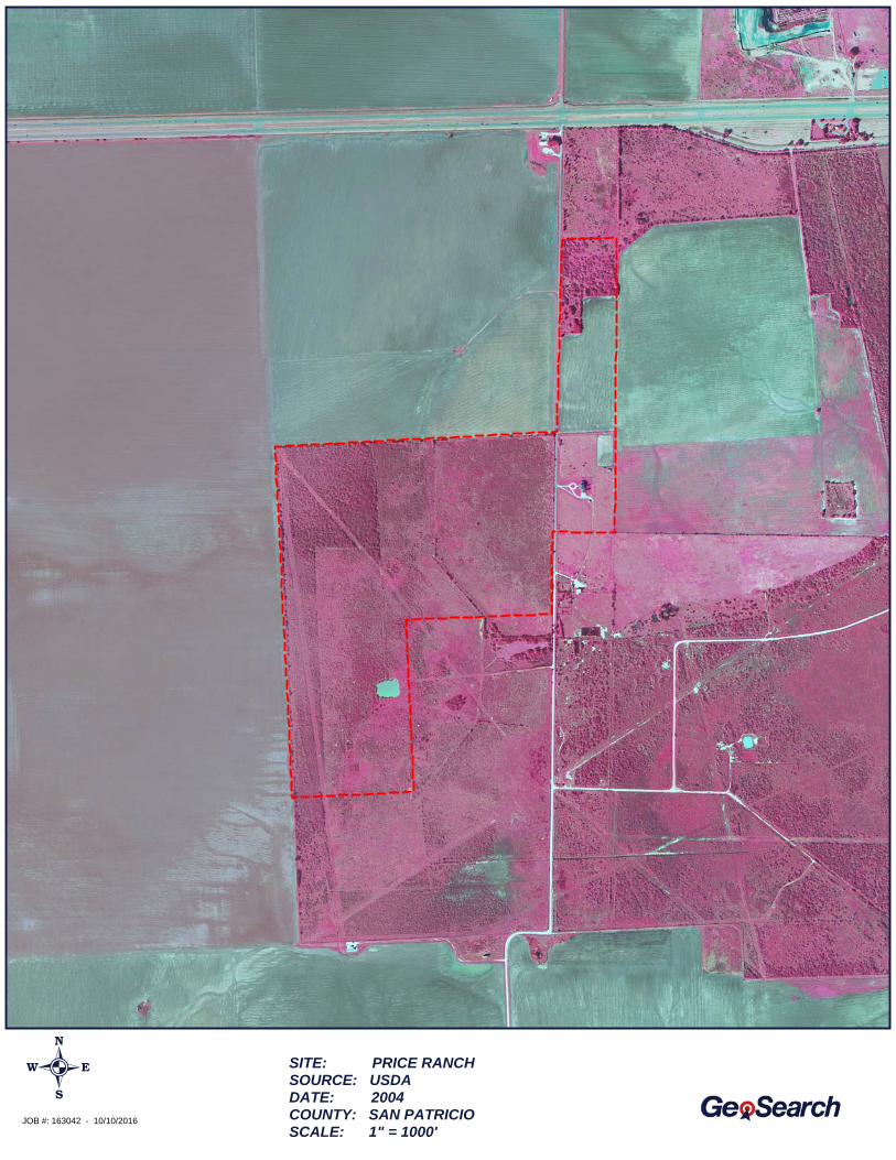
TOPOGRAPHIC MAP
JOB #: 163042 - 10/10/2016
SITE: PRICE RANCHSOURCE: USDADATE: 2004COUNTY: SAN PATRICIOSCALE: 1" = 1000'
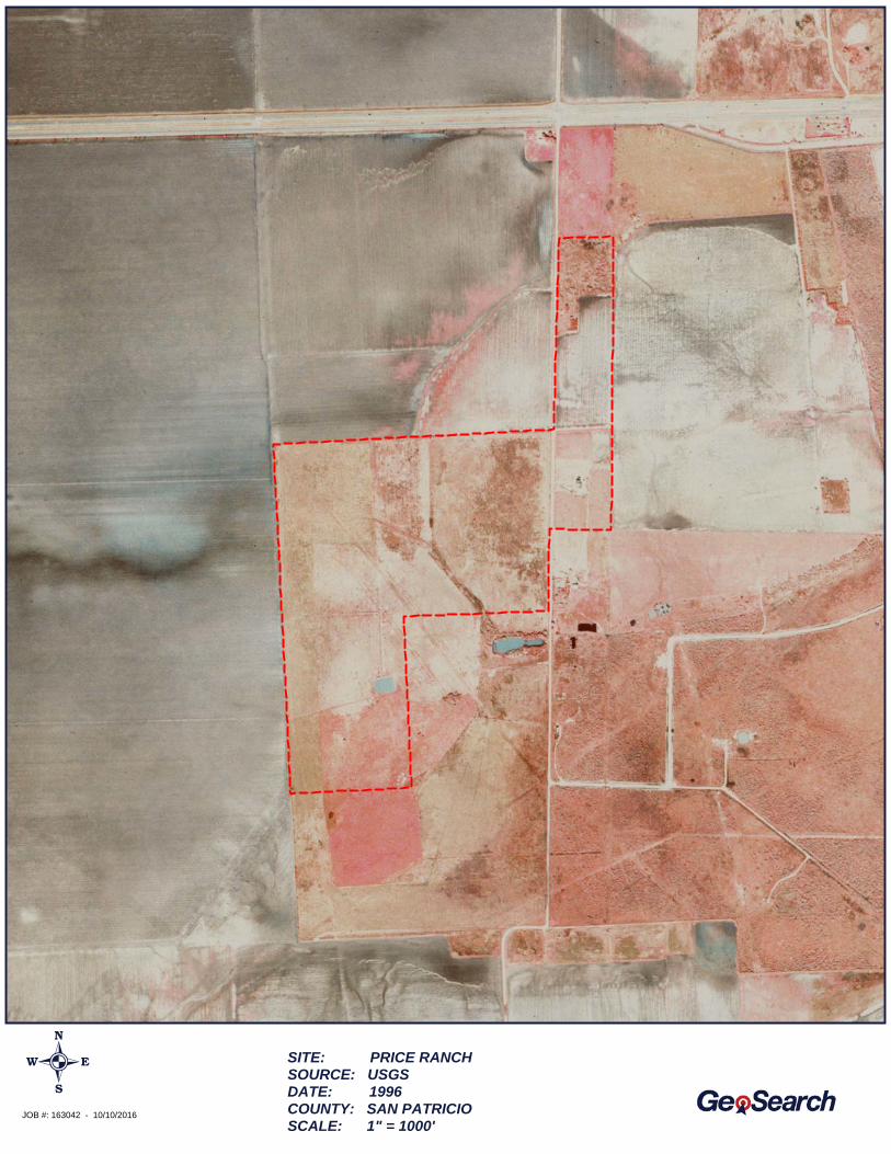
TOPOGRAPHIC MAP
JOB #: 163042 - 10/10/2016
SITE: PRICE RANCHSOURCE: USGSDATE: 1996COUNTY: SAN PATRICIOSCALE: 1" = 1000'
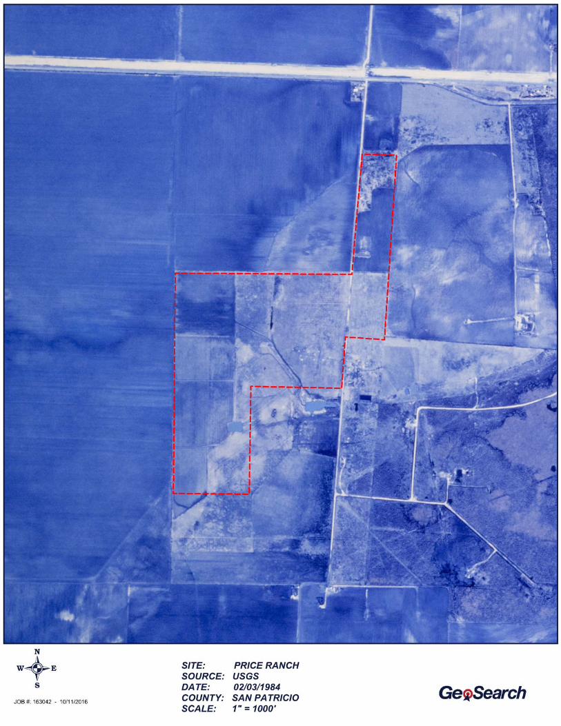

TOPOGRAPHIC MAP
JOB #: 163042 - 10/10/2016
SITE: PRICE RANCHSOURCE: USGSDATE: 12/12/1972COUNTY: SAN PATRICIOSCALE: 1" = 1000'

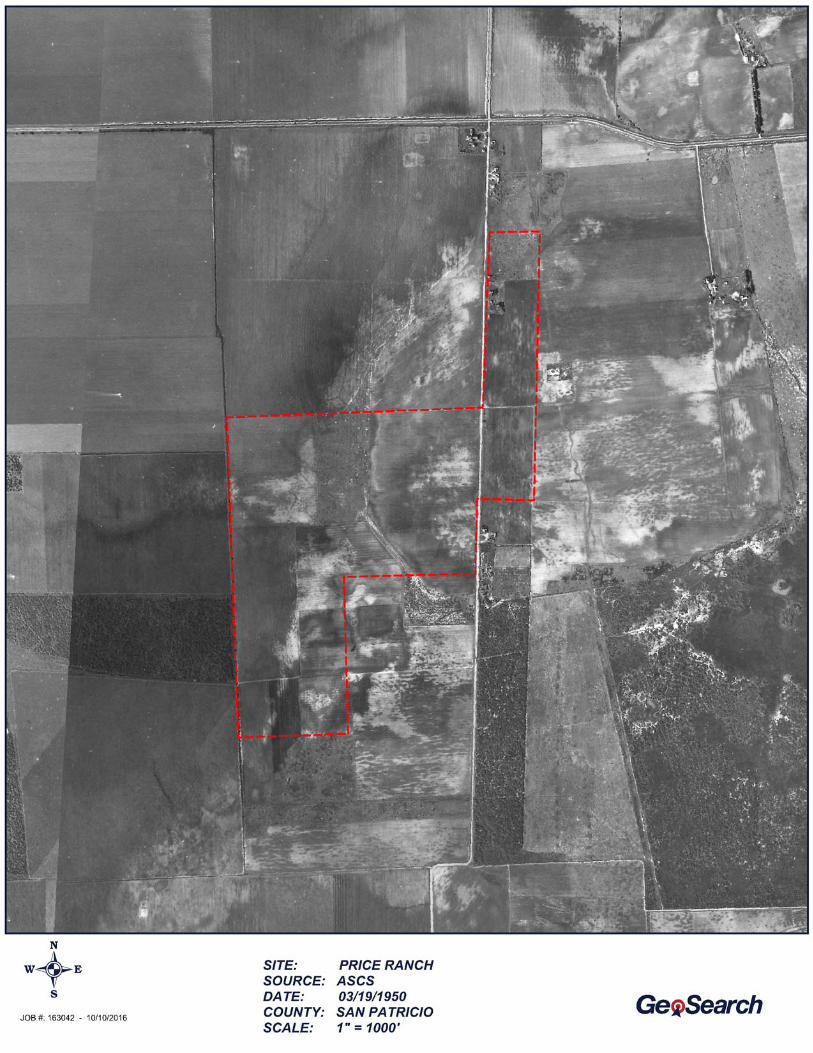
EXHIBIT D
Historical Topographic Map Report
Target Property:
Prepared For:
Historical Topographic Maps
Gregory, San Patricio County, Texas 78374Price Ranch
Testengeer Inc
Job #: 163037Order #: 75842
Date: 10/06/2016
http://www.geo-search.net/QuickMap/index.htm?DataID=Standard0000163037Click on link above to access the map and satellite view of current property
Project #: 20109838
phone: 888-396-0042 · fax: 512-472-9967 · www.geo-search.com
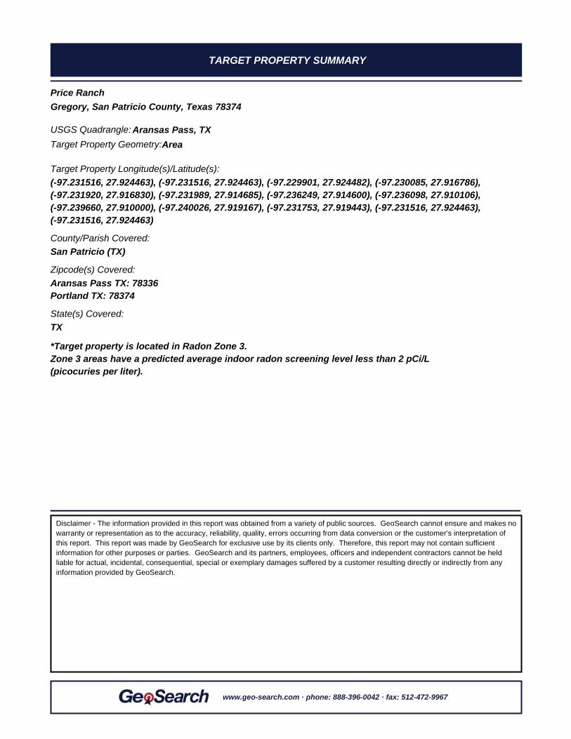
TARGET PROPERTY SUMMARY
Gregory, San Patricio County, Texas 78374Price Ranch
*Target property is located in Radon Zone 3.Zone 3 areas have a predicted average indoor radon screening level less than 2 pCi/L(picocuries per liter).
County/Parish Covered:
Zipcode(s) Covered:
State(s) Covered:
San Patricio (TX)
Aransas Pass TX: 78336Portland TX: 78374
TX
Target Property Geometry:Area
Target Property Longitude(s)/Latitude(s):(-97.231516, 27.924463), (-97.231516, 27.924463), (-97.229901, 27.924482), (-97.230085, 27.916786),(-97.231920, 27.916830), (-97.231989, 27.914685), (-97.236249, 27.914600), (-97.236098, 27.910106),(-97.239660, 27.910000), (-97.240026, 27.919167), (-97.231753, 27.919443), (-97.231516, 27.924463),(-97.231516, 27.924463)
USGS Quadrangle: Aransas Pass, TX
Disclaimer - The information provided in this report was obtained from a variety of public sources. GeoSearch cannot ensure and makes nowarranty or representation as to the accuracy, reliability, quality, errors occurring from data conversion or the customer’s interpretation ofthis report. This report was made by GeoSearch for exclusive use by its clients only. Therefore, this report may not contain sufficientinformation for other purposes or parties. GeoSearch and its partners, employees, officers and independent contractors cannot be heldliable for actual, incidental, consequential, special or exemplary damages suffered by a customer resulting directly or indirectly from anyinformation provided by GeoSearch.
www.geo-search.com · phone: 888-396-0042 · fax: 512-472-9967
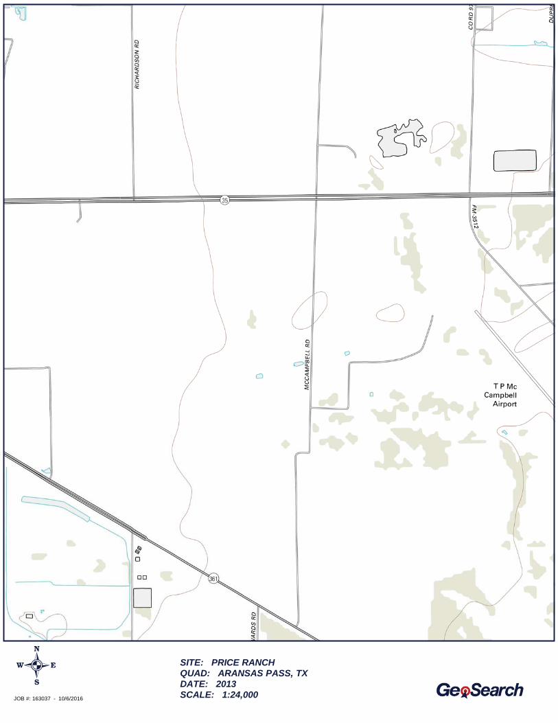
TOPOGRAPHIC MAP
JOB #: 163037 - 10/6/2016
SITE: PRICE RANCHQUAD: ARANSAS PASS, TXDATE: 2013SCALE: 1:24,000
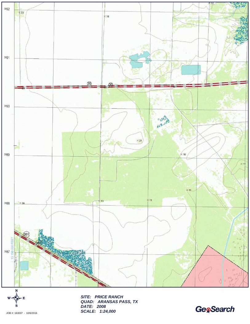
TOPOGRAPHIC MAP
JOB #: 163037 - 10/6/2016
SITE: PRICE RANCHQUAD: ARANSAS PASS, TXDATE: 2008SCALE: 1:24,000
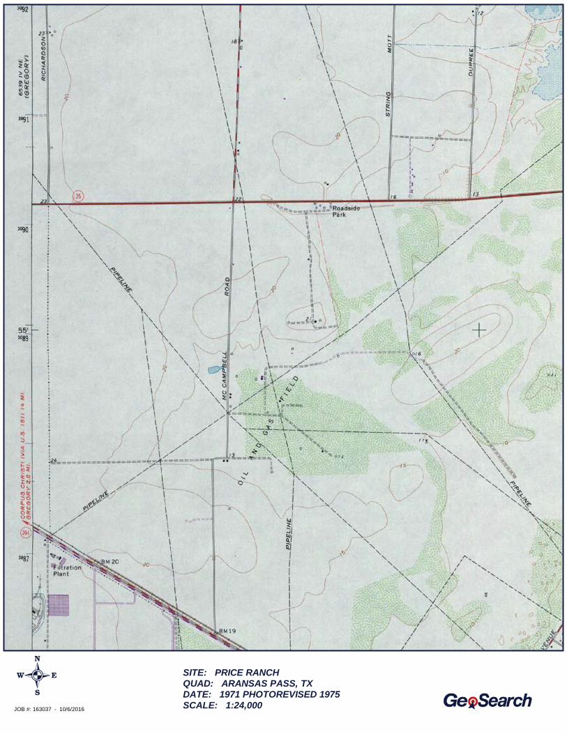
TOPOGRAPHIC MAP
JOB #: 163037 - 10/6/2016
SITE: PRICE RANCHQUAD: ARANSAS PASS, TXDATE: 1971 PHOTOREVISED 1975SCALE: 1:24,000
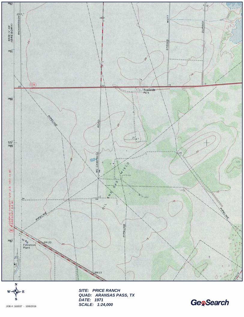
TOPOGRAPHIC MAP
JOB #: 163037 - 10/6/2016
SITE: PRICE RANCHQUAD: ARANSAS PASS, TXDATE: 1971SCALE: 1:24,000

TOPOGRAPHIC MAP
JOB #: 163037 - 10/6/2016
SITE: PRICE RANCHQUAD: ARANSAS PASS, TXDATE: 1954SCALE: 1:62,500
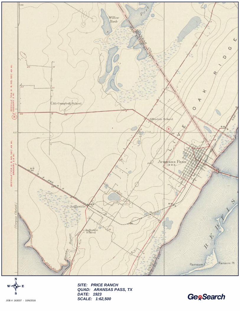
TOPOGRAPHIC MAP
JOB #: 163037 - 10/6/2016
SITE: PRICE RANCHQUAD: ARANSAS PASS, TXDATE: 1923SCALE: 1:62,500
EXHIBIT E
City Directory Report
City Directory Standard Report
Target Property:
County Road 93,
Aransas Pass, TX 78374
Prepared For:Testengeer Inc
Order #: 75842
Date: 10/5/2016
Project #: 20109838
888-396-0042 www.geo-search.com
Page 1 of 2
10/5/2016 2:21:25 PM
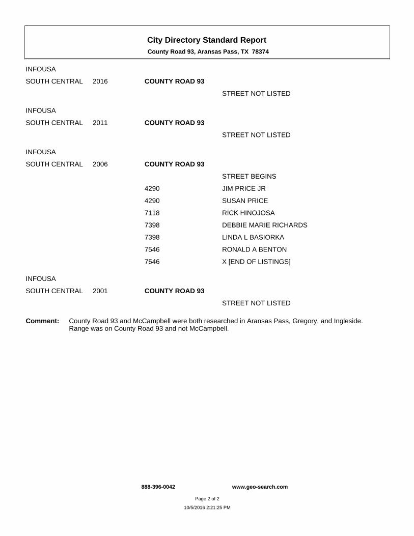
City Directory Standard Report County Road 93, Aransas Pass, TX 78374
INFOUSA
SOUTH CENTRAL 2016 COUNTY ROAD 93
STREET NOT LISTED
INFOUSA
SOUTH CENTRAL 2011 COUNTY ROAD 93
STREET NOT LISTED
INFOUSA
SOUTH CENTRAL 2006 COUNTY ROAD 93
STREET BEGINS
4290 JIM PRICE JR
4290 SUSAN PRICE
7118 RICK HINOJOSA
7398 DEBBIE MARIE RICHARDS
7398 LINDA L BASIORKA
7546 RONALD A BENTON
7546 X [END OF LISTINGS]
INFOUSA
SOUTH CENTRAL 2001 COUNTY ROAD 93
STREET NOT LISTED
Comment: County Road 93 and McCampbell were both researched in Aransas Pass, Gregory, and Ingleside. Range was on County Road 93 and not McCampbell.
888-396-0042 www.geo-search.com
Page 2 of 2
10/5/2016 2:21:25 PM
EXHIBIT F
Fire Insurance Maps Report
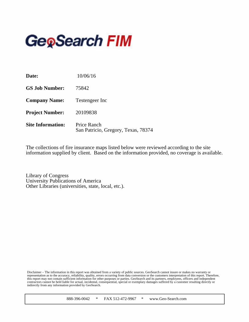
Date: 10/06/16
GS Job Number: 75842
Company Name: Testengeer Inc
Project Number: 20109838
Site Information: Price RanchSan Patricio, Gregory, Texas, 78374
The collections of fire insurance maps listed below were reviewed according to the siteinformation supplied by client. Based on the information provided, no coverage is available.
Library of CongressUniversity Publications of AmericaOther Libraries (universities, state, local, etc.).
Disclaimer – The information in this report was obtained from a variety of public sources. GeoSearch cannot insure or makes no warranty orrepresentation as to the accuracy, reliability, quality, errors occurring from data conversion or the customers interpretation of this report. Therefore,this report may not contain sufficient information for other purposes or parties. GeoSearch and its partners, employees, officers and independentcontractors cannot be held liable for actual, incidental, consequential, special or exemplary damages suffered by a customer resulting directly orindirectly from any information provided by GeoSearch.
888-396-0042 * FAX 512-472-9967 * www.Geo-Search.com
EXHIBIT G
Environmental Lien Search
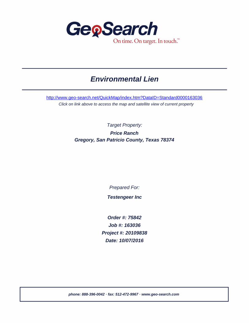
Target Property:
Prepared For:
Environmental Lien
Gregory, San Patricio County, Texas 78374Price Ranch
Testengeer Inc
Job #: 163036Order #: 75842
Date: 10/07/2016
http://www.geo-search.net/QuickMap/index.htm?DataID=Standard0000163036Click on link above to access the map and satellite view of current property
Project #: 20109838
phone: 888-396-0042 · fax: 512-472-9967 · www.geo-search.com

TARGET PROPERTY SUMMARY
Gregory, San Patricio County, Texas 78374Price Ranch
*Target property is located in Radon Zone 3.Zone 3 areas have a predicted average indoor radon screening level less than 2 pCi/L(picocuries per liter).
County/Parish Covered:
Zipcode(s) Covered:
State(s) Covered:
San Patricio (TX)
Aransas Pass TX: 78336Portland TX: 78374
TX
Target Property Geometry:Area
Target Property Longitude(s)/Latitude(s):(-97.231516, 27.924463), (-97.231516, 27.924463), (-97.229901, 27.924482), (-97.230085, 27.916786),(-97.231920, 27.916830), (-97.231989, 27.914685), (-97.236249, 27.914600), (-97.236098, 27.910106),(-97.239660, 27.910000), (-97.240026, 27.919167), (-97.231753, 27.919443), (-97.231516, 27.924463),(-97.231516, 27.924463)
USGS Quadrangle: Aransas Pass, TX
Disclaimer - The information provided in this report was obtained from a variety of public sources. GeoSearch cannot ensure and makes nowarranty or representation as to the accuracy, reliability, quality, errors occurring from data conversion or the customer’s interpretation ofthis report. This report was made by GeoSearch for exclusive use by its clients only. Therefore, this report may not contain sufficientinformation for other purposes or parties. GeoSearch and its partners, employees, officers and independent contractors cannot be heldliable for actual, incidental, consequential, special or exemplary damages suffered by a customer resulting directly or indirectly from anyinformation provided by GeoSearch.
www.geo-search.com · phone: 888-396-0042 · fax: 512-472-9967
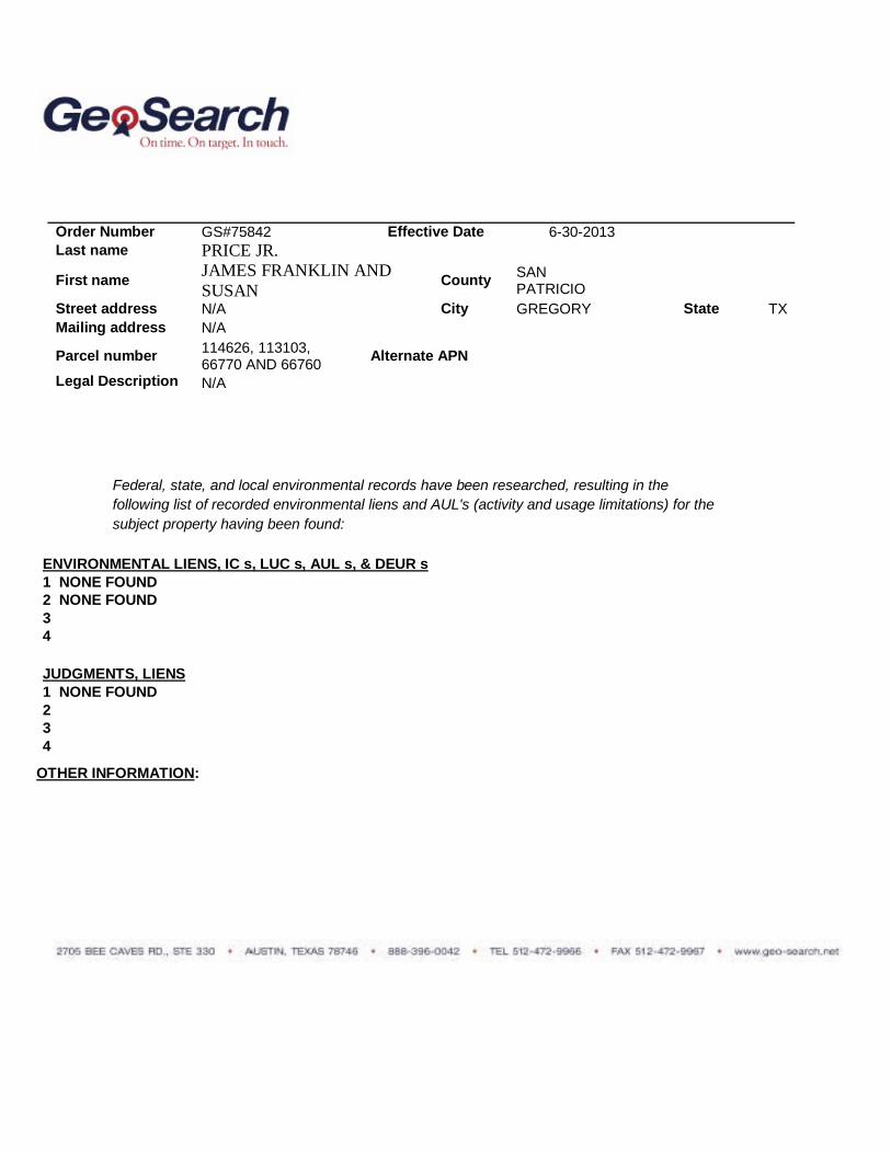
Federal, state, and local environmental records have been researched, resulting in the following list of recorded environmental liens and AUL's (activity and usage limitations) for the subject property having been found:
ENVIRONMENTAL LIENS, IC s, LUC s, AUL s, & DEUR s 1 NONE FOUND 2 NONE FOUND 3 4 JUDGMENTS, LIENS 1 NONE FOUND 2 3 4
OTHER INFORMATION:
Order Number GS#75842 Effective Date 6-30-2013 Last name PRICE JR.
First name JAMES FRANKLIN AND SUSAN County SAN
PATRICIO Street address N/A City GREGORY State TX Mailing address N/A Parcel number 114626, 113103,
66770 AND 66760 Alternate APN
Legal Description N/A
EXHIBIT H
Oil and Gas Report

GeoPlus Oil & Gas Report
Satellite view
Target Property:
Price Ranch
Gregory, San Patricio County, Texas 78374
Prepared For:
Testengeer Inc
Order #: 75842
Job #: 163039
Project #: 20109838
Date: 10/05/2016
0 of 6
www.geo-search.com 888-396-0042
Order# 75842 Job# 163039

Target Property Summary 1
Database Radius Summary 2
Oil & Gas Map 3
Located Sites Summary 4
Oil & Gas Well Report 5
Environmental Records Definitions 6
www.geo-search.com 888-396-0042
Order# 75842 Job# 163039
Target Property SummaryDatabase Radius SummaryLocated Sites SummaryOil & Gas Well ReportEnvironmental Records Definitions - STATE (TX)Table of Contents
The information provided in this report was obtained from a variety of public sources. GeoSearch cannot ensure and makes nowarranty or representation as to the accuracy, reliability, quality, errors occurring from data conversion or the customer's interpretation ofthis report. This report was made by GeoSearch for exclusive use by its clients only. Therefore, this report may not contain sufficientinformation for other purposes or parties. GeoSearch and its partners, employees, officers And independent contractors cannot be heldliable For actual, incidental, consequential, special or exemplary damages suffered by a customer resulting directly or indirectly from anyinformation provided by GeoSearch.
www.geo-search.com 888-396-0042
Order# 75842 Job# 163039
Target Property SummaryDatabase Radius SummaryLocated Sites SummaryOil & Gas Well ReportEnvironmental Records Definitions - STATE (TX)Table of ContentsDisclaimer

Target Property InformationPrice RanchGregory, Texas 78374
CoordinatesArea
USGS QuadrangleAransas Pass, TX
Geographic Coverage InformationCounty/Parish: San Patricio (TX) ZipCode(s): Aransas Pass TX: 78336Portland TX: 78374
Radon* Target property is located in Radon Zone 3.Zone 3 areas have a predicted average indoor radon screening level less than 2 pCi/L (picocuries per liter).
1 of 6
www.geo-search.com 888-396-0042
Order# 75842 Job# 163039
Target Property Summary
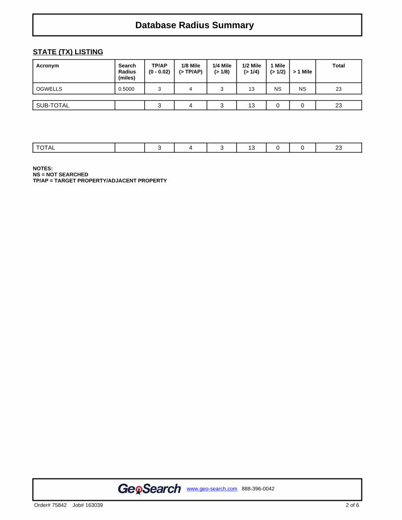
STATE (TX) LISTING
Acronym SearchRadius(miles)
TP/AP(0 - 0.02)
1/8 Mile(> TP/AP)
1/4 Mile(> 1/8)
1/2 Mile(> 1/4)
1 Mile(> 1/2) > 1 Mile
Total
OGWELLS 0.5000 3 4 3 13 NS NS 23
SUB-TOTAL 3 4 3 13 0 0 23
TOTAL 3 4 3 13 0 0 23
NOTES:NS = NOT SEARCHEDTP/AP = TARGET PROPERTY/ADJACENT PROPERTY
2 of 6
www.geo-search.com 888-396-0042
Order# 75842 Job# 163039
Target Property SummaryDatabase Radius Summary
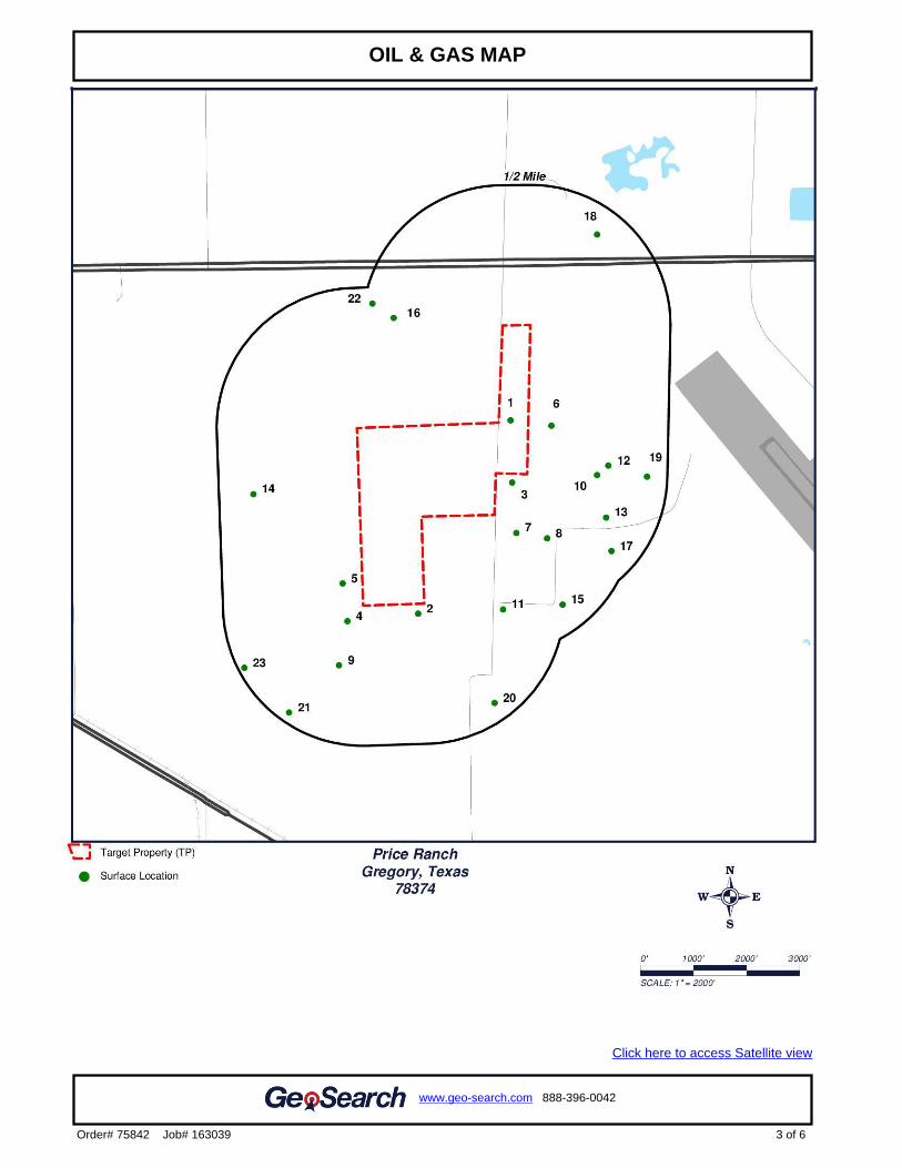
.2
Click here to access Satellite view
3 of 6
www.geo-search.com 888-396-0042
Order# 75842 Job# 163039
Target Property SummaryDatabase Radius SummaryOIL & GAS MAP

Map ID#
Database Name Site ID# DistanceFrom Site
Site Name Address
1 OGWELLS 37421 0.001 mi. S(5 ft.)
2 OGWELLS 37422 0.02 mi. S(106 ft.)
3 OGWELLS 37418 0.02 mi. S(106 ft.)
4 OGWELLS 37405 0.07 mi. SW(370 ft.)
5 OGWELLS 37404 0.07 mi. SW(370 ft.)
6 OGWELLS 37409 0.09 mi. SE(475 ft.)
7 OGWELLS 37413 0.1 mi. S(528 ft.)
8 OGWELLS 37414 0.2 mi. S(1056 ft.)
9 OGWELLS 37406 0.22 mi. SW(1162 ft.)
10 OGWELLS 37419 0.25 mi. SE(1320 ft.)
11 OGWELLS 37417 0.29 mi. S(1531 ft.)
12 OGWELLS 1060329 0.29 mi. SE(1531 ft.)
13 OGWELLS 37892 0.32 mi. SE(1690 ft.)
14 OGWELLS 37403 0.38 mi. SW(2006 ft.)
15 OGWELLS 37416 0.39 mi. S(2059 ft.)
16 OGWELLS 37411 0.4 mi. W(2112 ft.)
17 OGWELLS 37415 0.4 mi. SE(2112 ft.)
18 OGWELLS 37391 0.42 mi. NE(2218 ft.)
19 OGWELLS 37412 0.43 mi. SE(2270 ft.)
20 OGWELLS 37420 0.43 mi. S(2270 ft.)
21 OGWELLS 37893 0.45 mi. SW(2376 ft.)
22 OGWELLS 37402 0.46 mi. W(2429 ft.)
23 OGWELLS 37407 0.48 mi. SW(2534 ft.)
4 of 6
www.geo-search.com 888-396-0042
Order# 75842 Job# 163039
Target Property SummaryDatabase Radius SummaryLocated Sites Summary
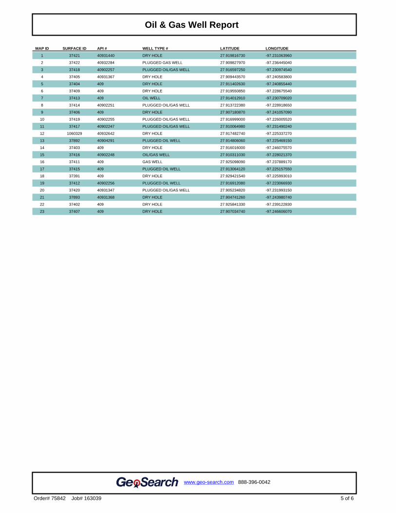
5 of 6
www.geo-search.com 888-396-0042
Order# 75842 Job# 163039
Target Property SummaryDatabase Radius SummaryLocated Sites SummaryOil & Gas Well Report
MAP ID SURFACE ID API # WELL TYPE # LATITUDE LONGITUDE
1 37421 40931440 DRY HOLE 27.919816730 -97.231063960
2 37422 40932284 PLUGGED GAS WELL 27.909827970 -97.236445040
3 37418 40902257 PLUGGED OIL/GAS WELL 27.916597250 -97.230974540
4 37405 40931367 DRY HOLE 27.909443570 -97.240583800
5 37404 409 DRY HOLE 27.911402630 -97.240855440
6 37409 409 DRY HOLE 27.919550850 -97.228675540
7 37413 409 OIL WELL 27.914012910 -97.230709020
8 37414 40902251 PLUGGED OIL/GAS WELL 27.913722380 -97.228918650
9 37406 409 DRY HOLE 27.907180870 -97.241057090
10 37419 40902255 PLUGGED OIL/GAS WELL 27.916999000 -97.226005520
11 37417 40902247 PLUGGED OIL/GAS WELL 27.910064980 -97.231490240
12 1060329 40932642 DRY HOLE 27.917482740 -97.225337270
13 37892 40904291 PLUGGED OIL WELL 27.914806060 -97.225469150
14 37403 409 DRY HOLE 27.916016000 -97.246075570
15 37416 40902248 OIL/GAS WELL 27.910311030 -97.228021370
16 37411 409 GAS WELL 27.925098090 -97.237889170
17 37415 409 PLUGGED OIL WELL 27.913064120 -97.225157550
18 37391 409 DRY HOLE 27.929421540 -97.225993010
19 37412 40902256 PLUGGED OIL WELL 27.916912080 -97.223066930
20 37420 40931347 PLUGGED OIL/GAS WELL 27.905234820 -97.231993150
21 37893 40931368 DRY HOLE 27.904741260 -97.243980740
22 37402 409 DRY HOLE 27.925841330 -97.239122830
23 37407 409 DRY HOLE 27.907034740 -97.246606070
OGWELLS Oil and Gas Wells
VERSION DATE: 03/23/16
This oil and gas well data set is provided by the Geographic Information System of the Railroad Commission of
Texas (the Commission). The data set includes oil and gas well records dating back to the early 1960’s, some
wells prior to the 1960’s are also included with with no API and/or a historical API number in place. The
Commission shall not be held liable for use of this data, which is provided as a public service for informational
purposes only. Users are responsible for checking the accuracy, completeness, currency, and/or suitability of
this data set themselves.
6 of 6
www.geo-search.com 888-396-0042
Order# 75842 Job# 163039
Target Property SummaryDatabase Radius SummaryLocated Sites SummaryOil & Gas Well ReportEnvironmental Records Definitions - STATE (TX)
EXHIBIT I
Water Well Report
GeoPlus Water Well Report
Satellite view
Target Property:
Price Ranch
Gregory, San Patricio County, Texas 78374
Prepared For:
Testengeer Inc
Order #: 75842
Job #: 163038
Project #: 20109838
Date: 10/05/2016
0 of 10
www.geo-search.com 888-396-0042
Order# 75842 Job# 163038
Target Property Summary 1
Database Radius Summary 2
Water Well Map 4
Located Sites Summary 5
Environmental Records Definitions 8
www.geo-search.com 888-396-0042
Order# 75842 Job# 163038
Target Property SummaryDatabase Radius SummaryLocated Sites SummaryTexas Water Development Board Groundwater Database (TWDB)Texas Water Development Board Groundwater Database (TWDB)Environmental Records Definitions - FEDERALEnvironmental Records Definitions - STATE (TX)Table of Contents

The information provided in this report was obtained from a variety of public sources. GeoSearch cannot ensure and makes nowarranty or representation as to the accuracy, reliability, quality, errors occurring from data conversion or the customer's interpretation ofthis report. This report was made by GeoSearch for exclusive use by its clients only. Therefore, this report may not contain sufficientinformation for other purposes or parties. GeoSearch and its partners, employees, officers And independent contractors cannot be heldliable For actual, incidental, consequential, special or exemplary damages suffered by a customer resulting directly or indirectly from anyinformation provided by GeoSearch.
www.geo-search.com 888-396-0042
Order# 75842 Job# 163038
Target Property SummaryDatabase Radius SummaryLocated Sites SummaryTexas Water Development Board Groundwater Database (TWDB)Texas Water Development Board Groundwater Database (TWDB)Environmental Records Definitions - FEDERALEnvironmental Records Definitions - STATE (TX)Table of ContentsDisclaimer
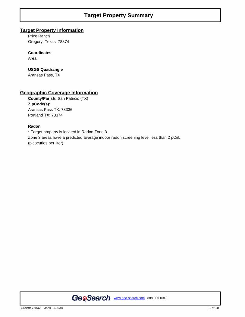
Target Property InformationPrice RanchGregory, Texas 78374
CoordinatesArea
USGS QuadrangleAransas Pass, TX
Geographic Coverage InformationCounty/Parish: San Patricio (TX) ZipCode(s): Aransas Pass TX: 78336Portland TX: 78374
Radon* Target property is located in Radon Zone 3.Zone 3 areas have a predicted average indoor radon screening level less than 2 pCi/L (picocuries per liter).
1 of 10
www.geo-search.com 888-396-0042
Order# 75842 Job# 163038
Target Property Summary
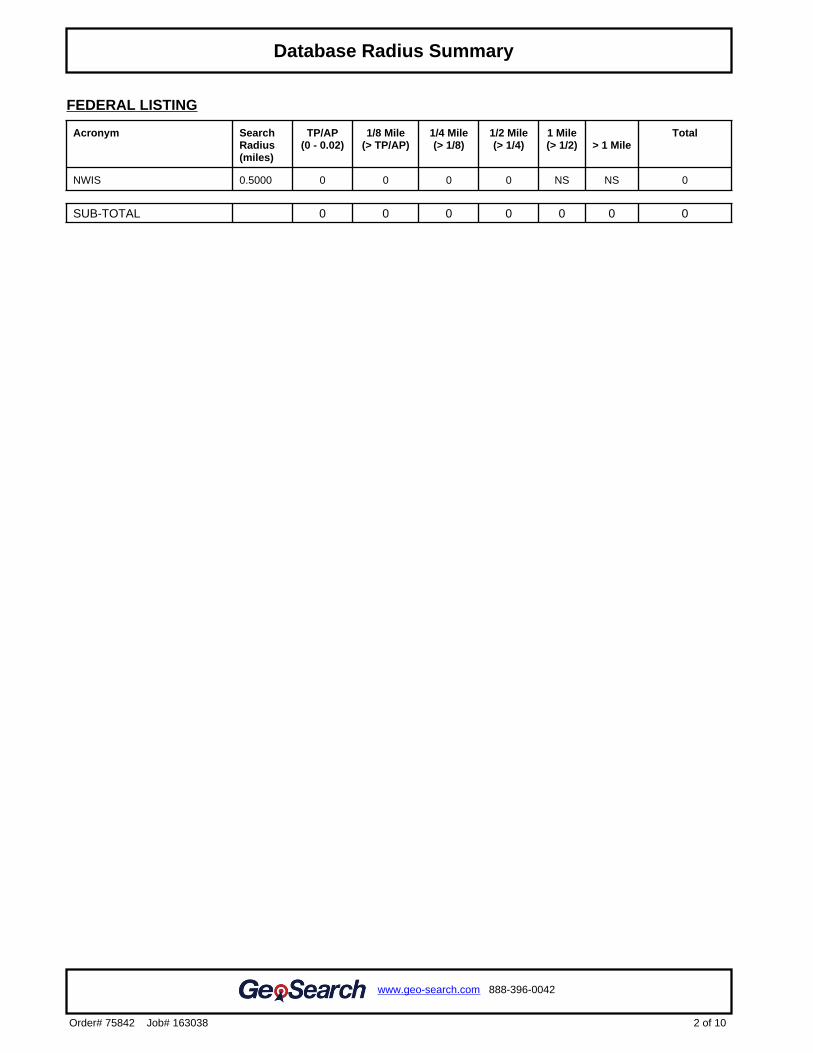
FEDERAL LISTING
Acronym SearchRadius(miles)
TP/AP(0 - 0.02)
1/8 Mile(> TP/AP)
1/4 Mile(> 1/8)
1/2 Mile(> 1/4)
1 Mile(> 1/2) > 1 Mile
Total
NWIS 0.5000 0 0 0 0 NS NS 0
SUB-TOTAL 0 0 0 0 0 0 0
2 of 10
www.geo-search.com 888-396-0042
Order# 75842 Job# 163038
Target Property SummaryDatabase Radius Summary
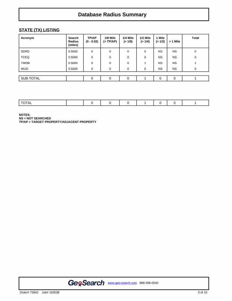
STATE (TX) LISTING
Acronym SearchRadius(miles)
TP/AP(0 - 0.02)
1/8 Mile(> TP/AP)
1/4 Mile(> 1/8)
1/2 Mile(> 1/4)
1 Mile(> 1/2) > 1 Mile
Total
SDRD 0.5000 0 0 0 0 NS NS 0
TCEQ 0.5000 0 0 0 0 NS NS 0
TWDB 0.5000 0 0 0 1 NS NS 1
WUD 0.5000 0 0 0 0 NS NS 0
SUB-TOTAL 0 0 0 1 0 0 1
TOTAL 0 0 0 1 0 0 1
NOTES:NS = NOT SEARCHEDTP/AP = TARGET PROPERTY/ADJACENT PROPERTY
3 of 10
www.geo-search.com 888-396-0042
Order# 75842 Job# 163038
Target Property SummaryDatabase Radius Summary
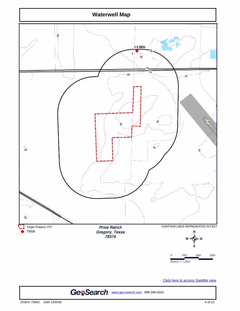
.2
Click here to access Satellite view
4 of 10
www.geo-search.com 888-396-0042
Order# 75842 Job# 163038
Target Property SummaryDatabase Radius SummaryWaterwell Map
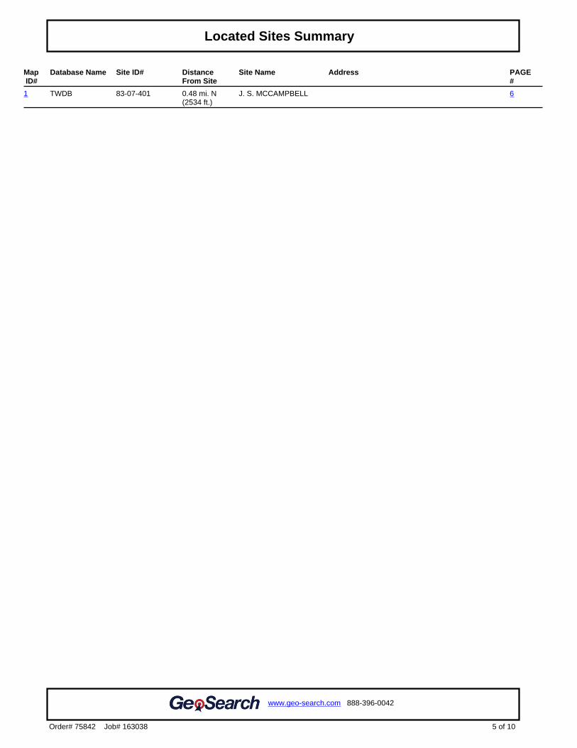
Map ID#
Database Name Site ID# DistanceFrom Site
Site Name Address PAGE#
1 TWDB 83-07-401 0.48 mi. N(2534 ft.)
J. S. MCCAMPBELL 6
5 of 10
www.geo-search.com 888-396-0042
Order# 75842 Job# 163038
Target Property SummaryDatabase Radius SummaryLocated Sites Summary
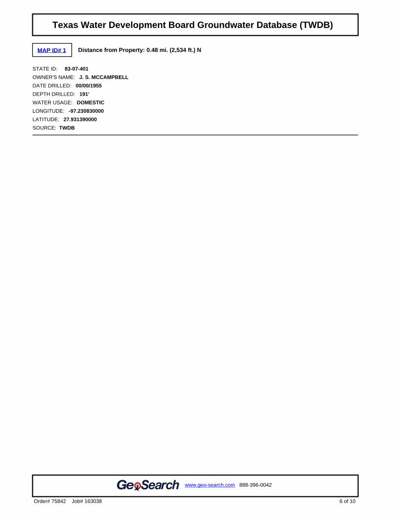
MAP ID# 1 Distance from Property: 0.48 mi. (2,534 ft.) N
STATE ID: 83-07-401
OWNER'S NAME: J. S. MCCAMPBELL
DATE DRILLED: 00/00/1955
DEPTH DRILLED: 191'
WATER USAGE: DOMESTIC
LONGITUDE: -97.230830000
LATITUDE: 27.931390000
SOURCE: TWDB
6 of 10
www.geo-search.com 888-396-0042
Order# 75842 Job# 163038
Target Property SummaryDatabase Radius SummaryLocated Sites SummaryTexas Water Development Board Groundwater Database (TWDB)
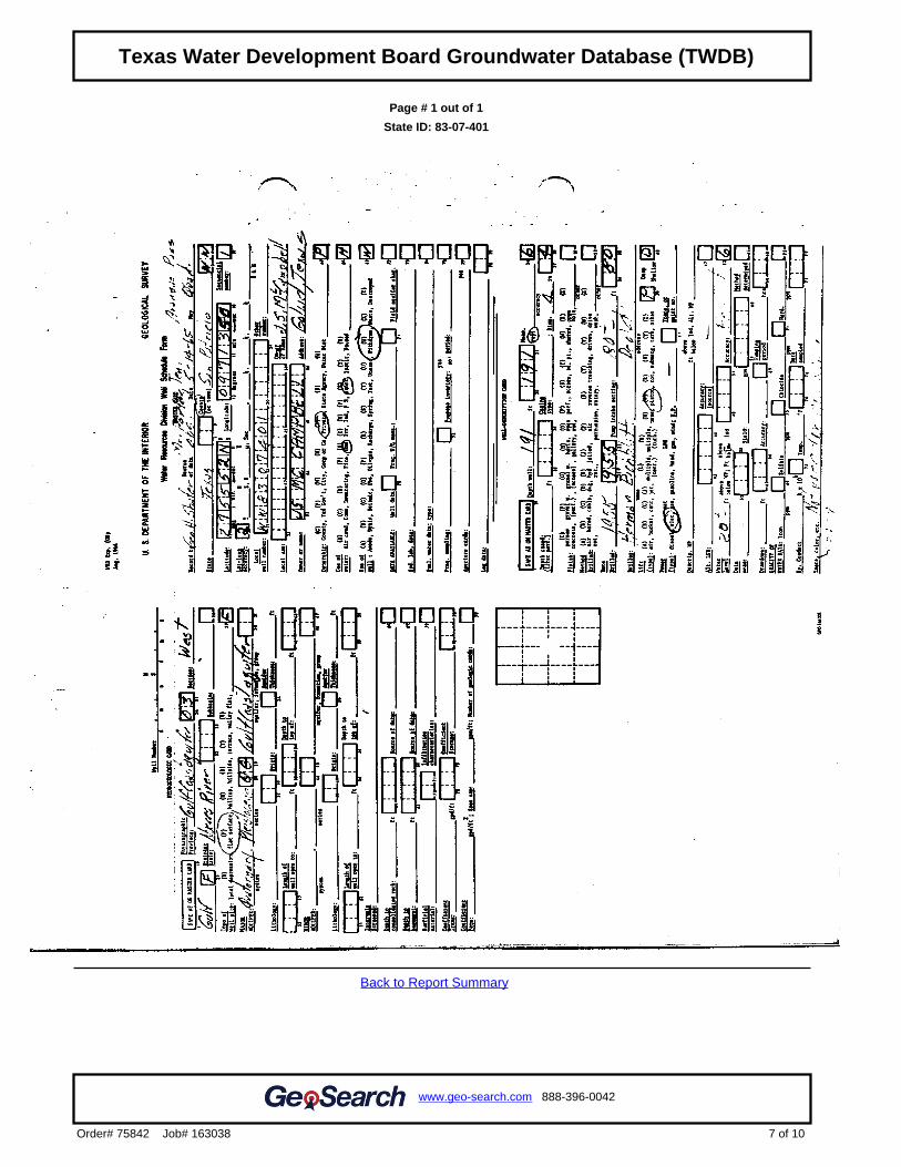
Page # 1 out of 1
State ID: 83-07-401
Back to Report Summary
7 of 10
www.geo-search.com 888-396-0042
Order# 75842 Job# 163038
Target Property SummaryDatabase Radius SummaryLocated Sites SummaryTexas Water Development Board Groundwater Database (TWDB)Texas Water Development Board Groundwater Database (TWDB)
NWIS United States Geological Survey National Water Information System
VERSION DATE: 05/14/15
This USGS National Water Information System database only includes groundwater wells. The USGS defines
this well type as: A hole or shaft constructed in the earth intended to be used to locate, sample, or develop
groundwater, oil, gas, or some other subsurface material. The diameter of a well is typically much smaller than
the depth. Wells are also used to artificially recharge groundwater or to pressurize oil and gas production zones.
Additional information about specific kinds of wells should be recorded under the secondary site types or the Use
of Site field. Underground waste-disposal wells should be classified as waste-injection wells.
8 of 10
www.geo-search.com 888-396-0042
Order# 75842 Job# 163038
Target Property SummaryDatabase Radius SummaryLocated Sites SummaryTexas Water Development Board Groundwater Database (TWDB)Texas Water Development Board Groundwater Database (TWDB)Environmental Records Definitions - FEDERAL
SDRD Submitted Drillers Report Database
VERSION DATE: 04/26/16
This Texas Water Development Board database was created from the online Texas Well Report Submission and
Retrieval System (A cooperative TDLR, TWDB system) that registered water-well drillers use to submit their
required reports. The system was started in February 2001 and is optional for the drillers to use.
TCEQ Texas Commission on Environmental Quality Water Wells
VERSION DATE: NR
The Texas Commission on Environmental Quality (TCEQ) maintains a filing system of plotted and unnumbered
water wells. Plotted water wells are filed according to the County indicated by the driller and the state well
number assigned by State of Texas personnel. Given the available location information provided by the driller,
personnel identify where the approximate well location should be. After well placement a state well number is
assigned indicating that the well lies within a specific 2.5’ section of a 7.5’ quadrangle. This method allows for
quicker, more refined, reference when researching a specific area. Unnumbered water wells have not been
assigned a state well number. This can occur for a variety of reasons; however it does not mean the well cannot
be accurately spotted. Unnumbered water well records are filed according to County and are often broken up by
year or by a span of years.
TWDB Texas Water Development Board Groundwater Database
VERSION DATE: 01/06/16
The Texas Water Development Board Groundwater Database contains information for more than 123,500 sites
in Texas including data on water wells, springs, oil/gas tests, water levels, and water quality. The purpose of the
Board's data collection effort over the years has been to gain representative information about aquifers in the
state in order to do water planning. It is very important, however, to realize that the wells in the database
represent only a small percentage of the wells that actually exist in Texas. A registered water well driller is
required by law to send in a report to the State for every well that is drilled. This requirement began in 1965, and
we estimate that approximately 500,000 wells have been drilled in Texas since then. Of the 1,000,000 plus
water wells drilled in Texas over the past 100 years, more than 130,000 have been inventoried and placed into
the TWDB groundwater database. State well numbers have been assigned to these based on their location
within numbered 7 1/2 minute quadrangles formed by lines of latitude and longitude. This database contains well
information including location, depth, well type, owner, driller, construction and completion data.
WUD Water Utility Database
VERSION DATE: 02/15/11
The Water Utility Database is defined as a collection of data from Texas Water Districts, Public Drinking Water
Systems and Water and Sewer Utilities who submit information to the TCEQ. This database is an integrated
database designed and developed to replace over 160 stand alone legacy systems representing over 5 million
records of the former Texas Water Commission and the Texas Department of Health.
9 of 10
www.geo-search.com 888-396-0042
Order# 75842 Job# 163038
Target Property SummaryDatabase Radius SummaryLocated Sites SummaryTexas Water Development Board Groundwater Database (TWDB)Texas Water Development Board Groundwater Database (TWDB)Environmental Records Definitions - FEDERALEnvironmental Records Definitions - STATE (TX)
10 of 10
www.geo-search.com 888-396-0042
Order# 75842 Job# 163038
Target Property SummaryDatabase Radius SummaryLocated Sites SummaryTexas Water Development Board Groundwater Database (TWDB)Texas Water Development Board Groundwater Database (TWDB)Environmental Records Definitions - FEDERALEnvironmental Records Definitions - STATE (TX)
EXHIBIT J
Railroad Commission of Texas Maps Report
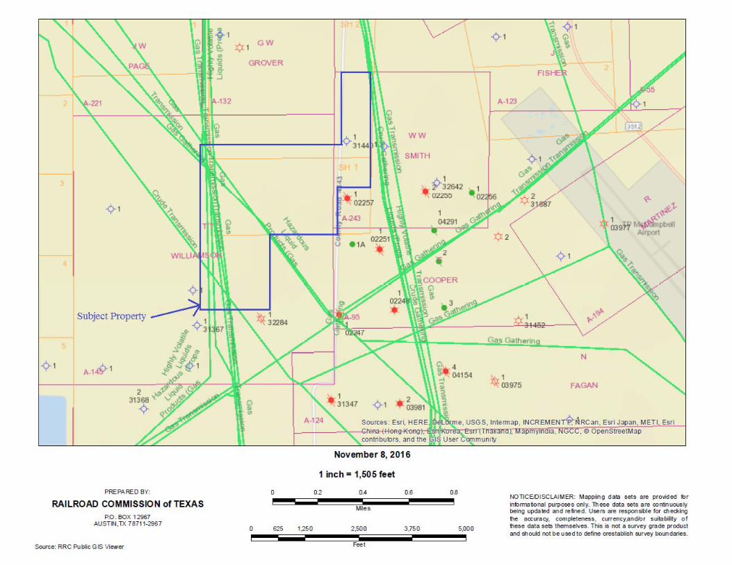
andyp
Callout
LINE 1
andyp
Callout
LINE 3
andyp
Callout
LINE 4
andyp
Callout
LINE 5
andyp
Callout
LINE 6
andyp
Callout
LINE 7
andyp
Callout
LINE 8
andyp
Callout
LINE 9
andyp
Callout
LINE 10
andyp
Callout
LINE 2
andyp
Callout
LINE 11
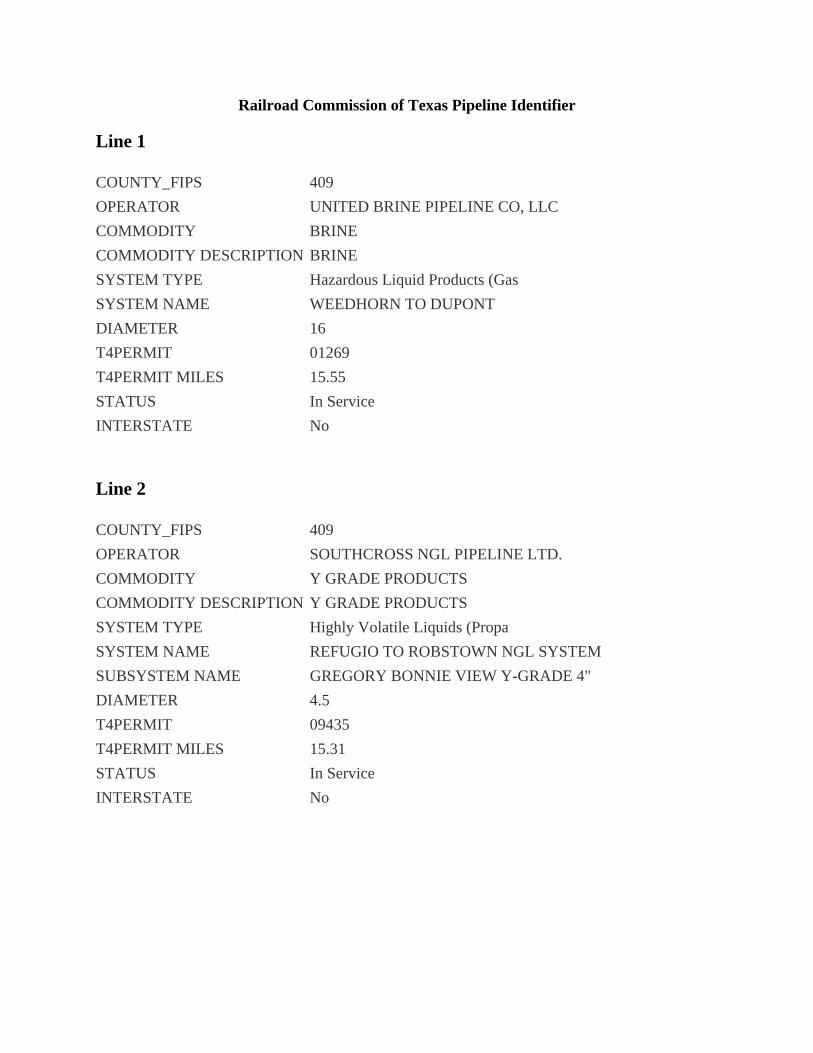
Railroad Commission of Texas Pipeline Identifier
Line 1
COUNTY_FIPS 409
OPERATOR UNITED BRINE PIPELINE CO, LLC
COMMODITY BRINE
COMMODITY DESCRIPTION BRINE
SYSTEM TYPE Hazardous Liquid Products (Gas
SYSTEM NAME WEEDHORN TO DUPONT
DIAMETER 16
T4PERMIT 01269
T4PERMIT MILES 15.55
STATUS In Service
INTERSTATE No
Line 2
COUNTY_FIPS 409
OPERATOR SOUTHCROSS NGL PIPELINE LTD.
COMMODITY Y GRADE PRODUCTS
COMMODITY DESCRIPTION Y GRADE PRODUCTS
SYSTEM TYPE Highly Volatile Liquids (Propa
SYSTEM NAME REFUGIO TO ROBSTOWN NGL SYSTEM
SUBSYSTEM NAME GREGORY BONNIE VIEW Y-GRADE 4"
DIAMETER 4.5
T4PERMIT 09435
T4PERMIT MILES 15.31
STATUS In Service
INTERSTATE No
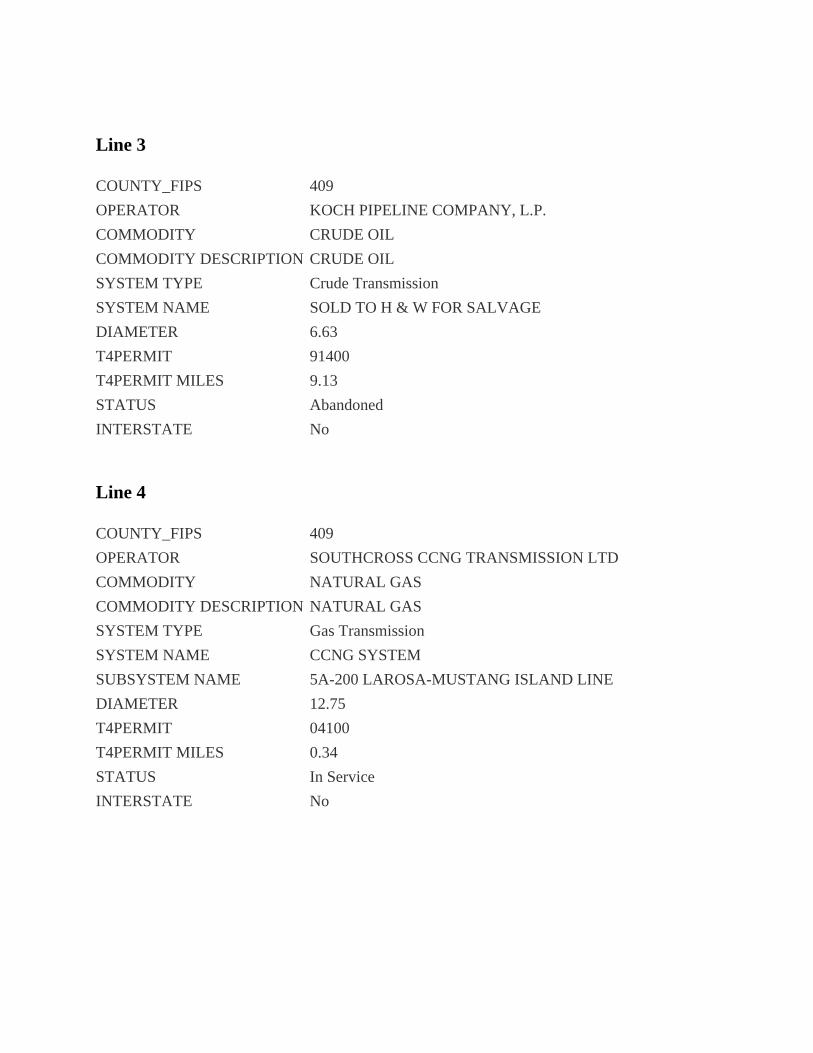
Line 3
COUNTY_FIPS 409
OPERATOR KOCH PIPELINE COMPANY, L.P.
COMMODITY CRUDE OIL
COMMODITY DESCRIPTION CRUDE OIL
SYSTEM TYPE Crude Transmission
SYSTEM NAME SOLD TO H & W FOR SALVAGE
DIAMETER 6.63
T4PERMIT 91400
T4PERMIT MILES 9.13
STATUS Abandoned
INTERSTATE No
Line 4
COUNTY_FIPS 409
OPERATOR SOUTHCROSS CCNG TRANSMISSION LTD
COMMODITY NATURAL GAS
COMMODITY DESCRIPTION NATURAL GAS
SYSTEM TYPE Gas Transmission
SYSTEM NAME CCNG SYSTEM
SUBSYSTEM NAME 5A-200 LAROSA-MUSTANG ISLAND LINE
DIAMETER 12.75
T4PERMIT 04100
T4PERMIT MILES 0.34
STATUS In Service
INTERSTATE No
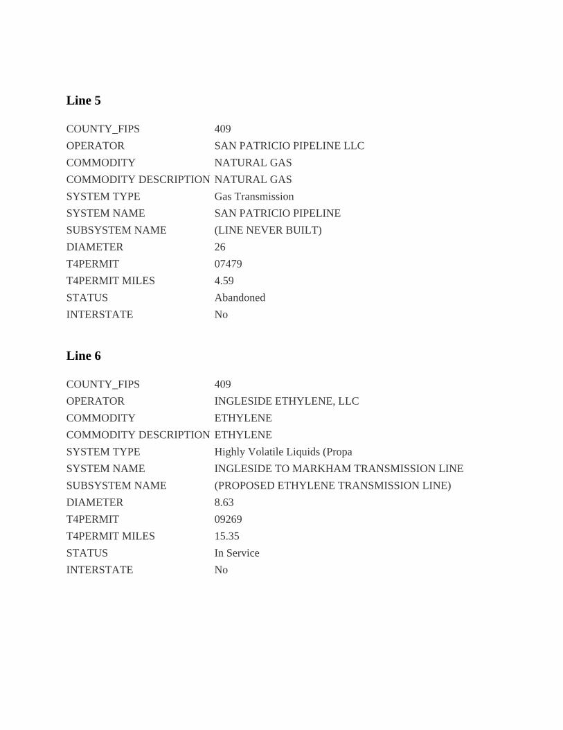
Line 5
COUNTY_FIPS 409
OPERATOR SAN PATRICIO PIPELINE LLC
COMMODITY NATURAL GAS
COMMODITY DESCRIPTION NATURAL GAS
SYSTEM TYPE Gas Transmission
SYSTEM NAME SAN PATRICIO PIPELINE
SUBSYSTEM NAME (LINE NEVER BUILT)
DIAMETER 26
T4PERMIT 07479
T4PERMIT MILES 4.59
STATUS Abandoned
INTERSTATE No
Line 6
COUNTY_FIPS 409
OPERATOR INGLESIDE ETHYLENE, LLC
COMMODITY ETHYLENE
COMMODITY DESCRIPTION ETHYLENE
SYSTEM TYPE Highly Volatile Liquids (Propa
SYSTEM NAME INGLESIDE TO MARKHAM TRANSMISSION LINE
SUBSYSTEM NAME (PROPOSED ETHYLENE TRANSMISSION LINE)
DIAMETER 8.63
T4PERMIT 09269
T4PERMIT MILES 15.35
STATUS In Service
INTERSTATE No
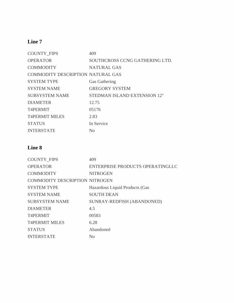
Line 7
COUNTY_FIPS 409
OPERATOR SOUTHCROSS CCNG GATHERING LTD.
COMMODITY NATURAL GAS
COMMODITY DESCRIPTION NATURAL GAS
SYSTEM TYPE Gas Gathering
SYSTEM NAME GREGORY SYSTEM
SUBSYSTEM NAME STEDMAN ISLAND EXTENSION 12"
DIAMETER 12.75
T4PERMIT 05176
T4PERMIT MILES 2.83
STATUS In Service
INTERSTATE No
Line 8
COUNTY_FIPS 409
OPERATOR ENTERPRISE PRODUCTS OPERATINGLLC
COMMODITY NITROGEN
COMMODITY DESCRIPTION NITROGEN
SYSTEM TYPE Hazardous Liquid Products (Gas
SYSTEM NAME SOUTH DEAN
SUBSYSTEM NAME SUNRAY-REDFISH (ABANDONED)
DIAMETER 4.5
T4PERMIT 00583
T4PERMIT MILES 6.28
STATUS Abandoned
INTERSTATE No
Line 9
COUNTY_FIPS 409
OPERATOR KOCH PIPELINE COMPANY, L.P.
COMMODITY CRUDE OIL
COMMODITY DESCRIPTION CRUDE OIL
SYSTEM TYPE Crude Gathering
SYSTEM NAME NORTH CRUDE SYSTEM
SUBSYSTEM NAME REFUGIO TO INGLESIDE TERMINAL, 12IN.
DIAMETER 12.75
T4PERMIT 00140
T4PERMIT MILES 15.280000000000001
STATUS In Service
INTERSTATE No
Line 10
COUNTY_FIPS 409
OPERATOR ENTERPRISE PRODUCTS OPERATINGLLC
COMMODITY ETHANE
COMMODITY DESCRIPTION ETHANE
SYSTEM TYPE Highly Volatile Liquids (Propa
SYSTEM NAME SHOUP TO MONT BELVIEU
SUBSYSTEM NAME SHOUP TO MT BELVIEU
DIAMETER 12.75
T4PERMIT 07403
T4PERMIT MILES 33.21
STATUS In Service
INTERSTATE No
Line 11
COUNTY_FIPS 409
OPERATOR KOCH PIPELINE COMPANY, L.P.
COMMODITY CRUDE OIL
COMMODITY DESCRIPTION CRUDE OIL
SYSTEM TYPE Crude Gathering
SYSTEM NAME NORTH CRUDE SYSTEM
SUBSYSTEM NAME MIDWAY TO INGLESIDE, 16IN.
DIAMETER 16
T4PERMIT 00140
T4PERMIT MILES 5.22
STATUS In Service
INTERSTATE No