Presented by Rosa Munzer November 12, 2008 Vancouver GIS Users Group An Over View of British...
18
Presented by Rosa Munzer November 12, 2008 Vancouver GIS Users Group An Over View of British Columbia Lands Information
-
date post
19-Dec-2015 -
Category
Documents
-
view
214 -
download
1
Transcript of Presented by Rosa Munzer November 12, 2008 Vancouver GIS Users Group An Over View of British...
Presented by Rosa Munzer
November 12, 2008
Vancouver GIS Users Group
An Over View of British Columbia Lands Information
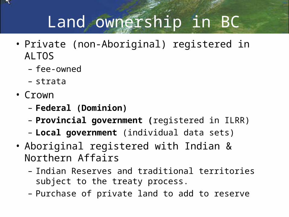
Land ownership in BC• Private (non-Aboriginal) registered in ALTOS
– fee-owned – strata
• Crown – Federal (Dominion)– Provincial government (registered in ILRR)– Local government (individual data sets)
• Aboriginal registered with Indian & Northern Affairs– Indian Reserves and traditional territories subject to the
treaty process. – Purchase of private land to add to reserve
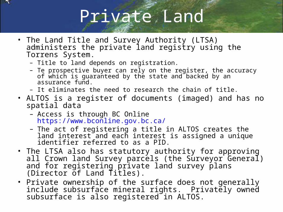
Private Land• The Land Title and Survey Authority (LTSA) administers the
private land registry using the Torrens System. – Title to land depends on registration. – Te prospective buyer can rely on the register, the accuracy of which is
guaranteed by the state and backed by an assurance fund. – It eliminates the need to research the chain of title.
• ALTOS is a register of documents (imaged) and has no spatial data– Access is through BC Online https://www.bconline.gov.bc.ca/– The act of registering a title in ALTOS creates the land interest
and each interest is assigned a unique identifier referred to as a PID.
• The LTSA also has statutory authority for approving all Crown land Survey parcels (the Surveyor General) and for registering private land survey plans (Director of Land Titles).
• Private ownership of the surface does not generally include subsurface mineral rights. Privately owned subsurface is also registered in ALTOS.
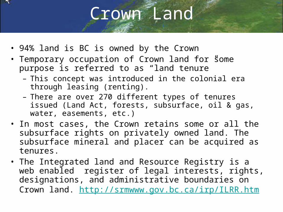
Crown Land
• 94% land is BC is owned by the Crown• Temporary occupation of Crown land for some purpose is
referred to as “land tenure” – This concept was introduced in the colonial era through
leasing (renting).– There are over 270 different types of tenures issued (Land
Act, forests, subsurface, oil & gas, water, easements, etc.)• In most cases, the Crown retains some or all the
subsurface rights on privately owned land. The subsurface mineral and placer can be acquired as tenures.
• The Integrated land and Resource Registry is a web enabled register of legal interests, rights, designations, and administrative boundaries on Crown land. http://srmwww.gov.bc.ca/irp/ILRR.htm

Receipt and review application / request Issue right or interest
INTEGRATED LAND AND RESOURCE REGISTER
Rights maintenance
• Determine interests and encumbrances
• Evaluation • Status / Adjudication• Clearance• Referral• Negotiate• Stake• Assess• Notation of Interest• Agreement in Principle
• Designation• Permit• Licence / Lease• Grant• Free hold (private)• Record a claim• Restriction / Encumbrance• Right of Way /Easement• Administrative boundary• Treaty settlement lands• Designate archaeological site
• Update • interest • interest holder• parcel information• ownership (Crown / or private)
• restriction / condition• term • status
• Record work• Enforcement / Compliance • Terminate / Cancel / Expire
Crown Land Tenure - Rights Granting Life Cycle
Rights Granting Ministry or Agency
AC
TIV
ITIE
S
Queries and reports
Record
Register the right or interest in ILRR
Register or update “request”
Update right or interest
Record request Record
Access
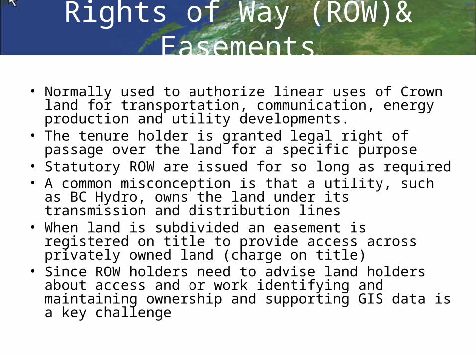
Rights of Way (ROW)& Easements
• Normally used to authorize linear uses of Crown land for transportation, communication, energy production and utility developments.
• The tenure holder is granted legal right of passage over the land for a specific purpose
• Statutory ROW are issued for so long as required• A common misconception is that a utility, such as BC
Hydro, owns the land under its transmission and distribution lines
• When land is subdivided an easement is registered on title to provide access across privately owned land (charge on title)
• Since ROW holders need to advise land holders about access and or work identifying and maintaining ownership and supporting GIS data is a key challenge
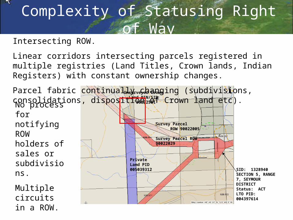
Unsurveyed Crown Land PIN/SID 36822581
Private Land PID 005039312
Survey Parcel ROW 90022029
Survey Parcel ROW 90022005
SID: 1328940 SECTION 5, RANGE 7, SEYMOUR DISTRICT Status: ACT LTO PID: 004397614
Complexity of Statusing Right of WayIntersecting ROW.
Linear corridors intersecting parcels registered in multiple registries (Land Titles, Crown lands, Indian Registers) with constant ownership changes.
Parcel fabric continually changing (subdivisions, consolidations, disposition of Crown land etc).
No process for notifying ROW holders of sales or subdivisions.
Multiple circuits in a ROW.
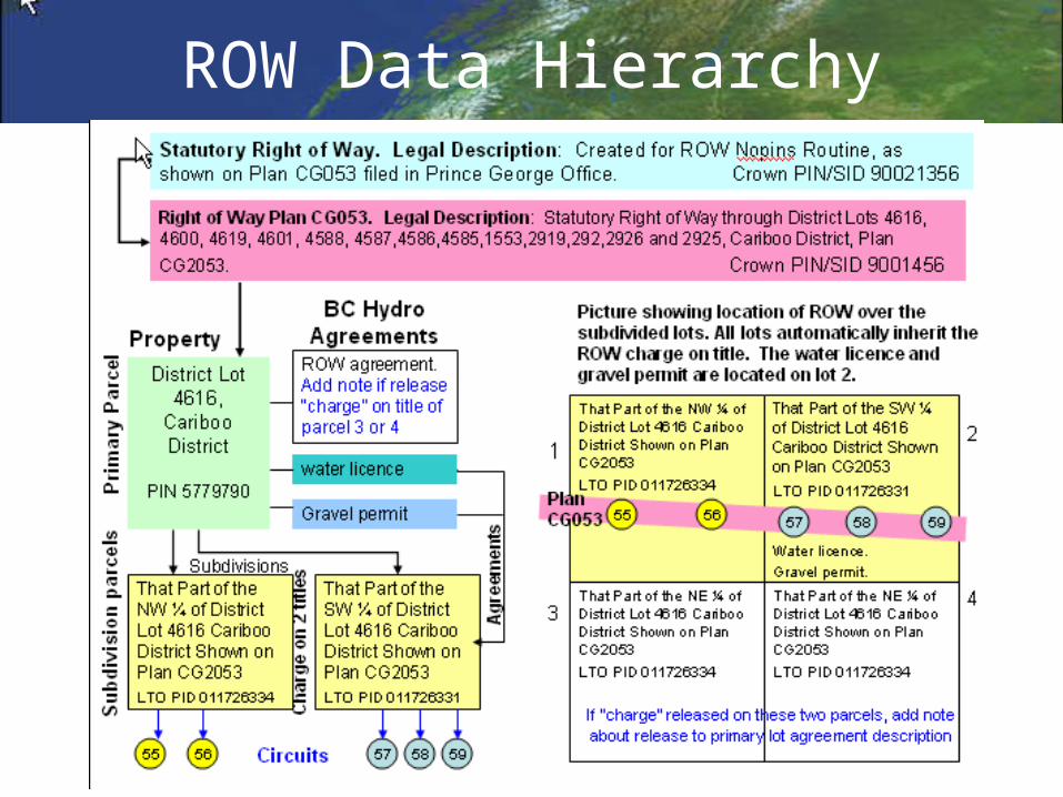
ROW Data Hierarchy
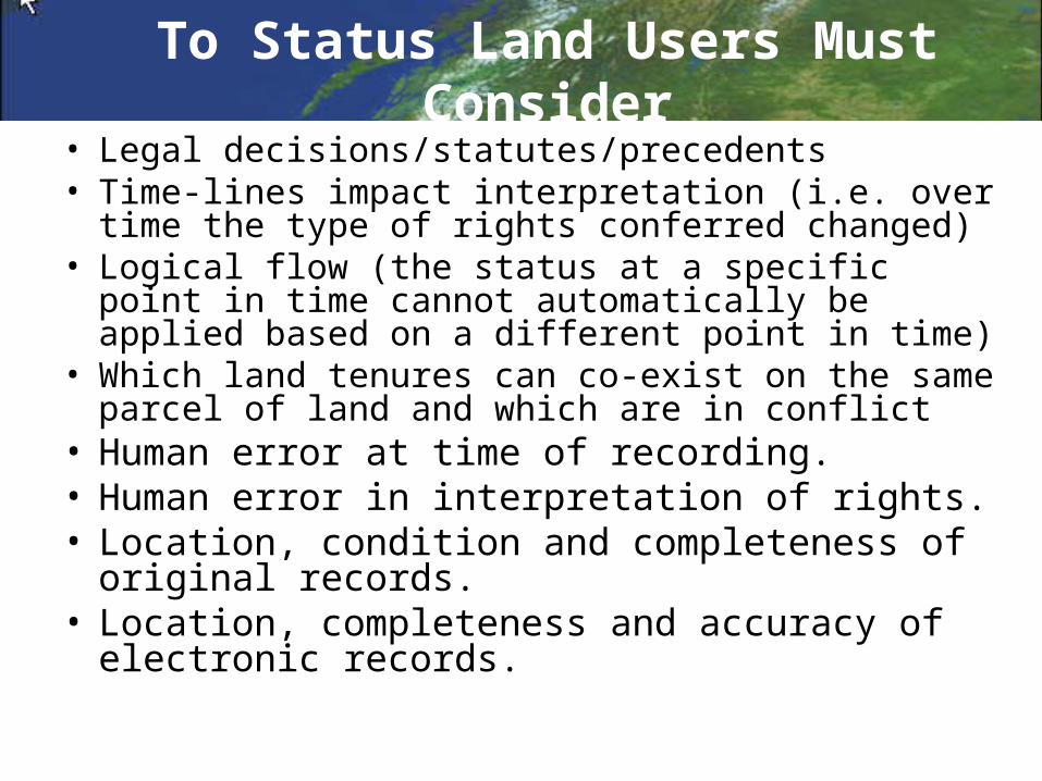
To Status Land Users Must Consider• Legal decisions/statutes/precedents• Time-lines impact interpretation (i.e. over time the
type of rights conferred changed)• Logical flow (the status at a specific point in time
cannot automatically be applied based on a different point in time)
• Which land tenures can co-exist on the same parcel of land and which are in conflict
• Human error at time of recording.• Human error in interpretation of rights.• Location, condition and completeness of original
records.• Location, completeness and accuracy of
electronic records.
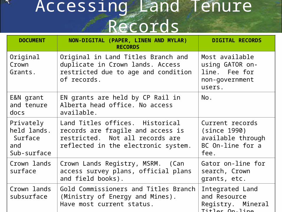
Accessing Land Tenure RecordsDOCUMENT NON-DIGITAL (PAPER, LINEN AND MYLAR)
RECORDSDIGITAL RECORDS
Original Crown Grants.
Original in Land Titles Branch and duplicate in Crown lands. Access restricted due to age and condition of records.
Most available using GATOR on-line. Fee for non-government users.
E&N grant and tenure docs
EN grants are held by CP Rail in Alberta head office. No access available.
No.
Privately held lands. Surface and Sub-surface
Land Titles offices. Historical records are fragile and access is restricted. Not all records are reflected in the electronic system.
Current records (since 1990) available through BC On-line for a fee.
Crown lands surface
Crown Lands Registry, MSRM. (Can access survey plans, official plans and field books).
Gator on-line for search, Crown grants, etc.
Crown lands subsurface
Gold Commissioners and Titles Branch (Ministry of Energy and Mines). Have most current status.
Integrated Land and Resource Registry. Mineral Titles On-line.
Reverted Crown Grants
•Sub-surface, Gold Commissioners, MEM.•Grants reverted due to non-payment of tax Resource Revenue, MEM.•Reverted surface rights, Crown Lands Registry.
No.
No.
ILLR and Gator on-line.
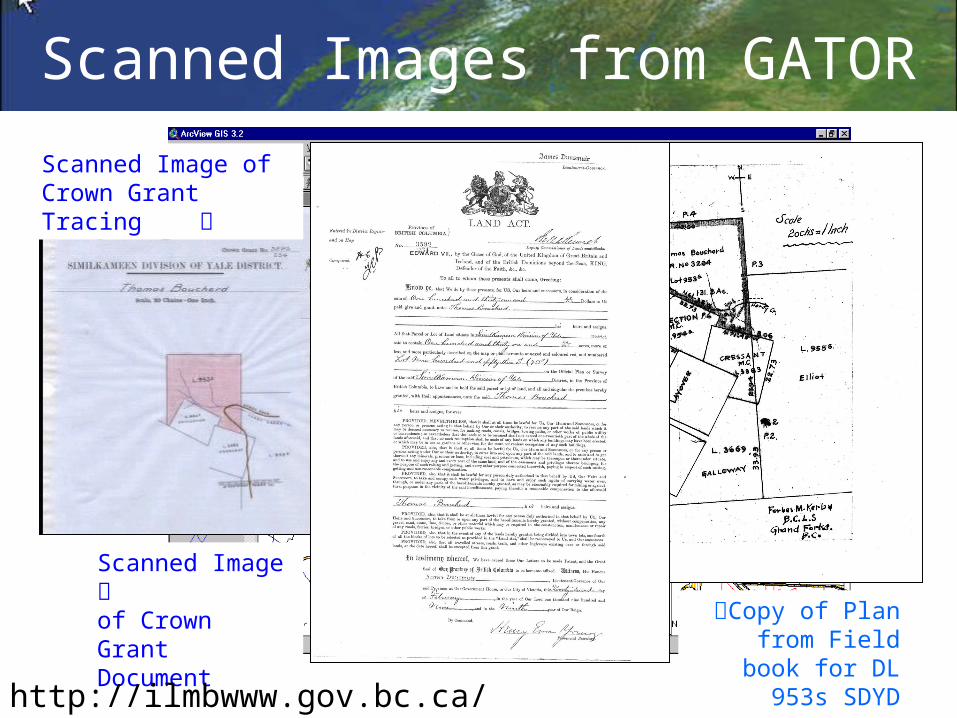
Scanned Image of Crown Grant Tracing
Scanned Image of Crown Grant Document Copy of Plan from
Field book for DL 953s SDYD
Scanned Images from GATOR
http://ilmbwww.gov.bc.ca/irb/gator/

Spatial Data Challenge
• ICIS provides There is no single source for all needed spatial information
• Everyone depends on spatial data from multiple external sources
• Multiple GIS software systems and map projections are in use: – Provincial Gov’t, ERSI– Utilities, SmallWorld, – Municipalities, various
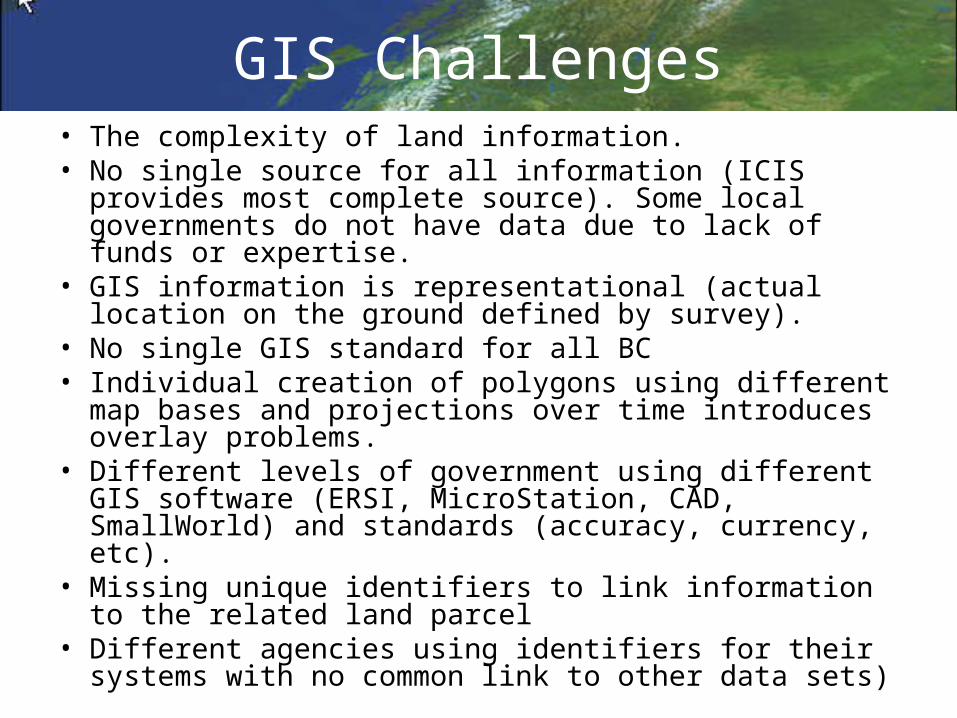
GIS Challenges• The complexity of land information. • No single source for all information (ICIS provides most
complete source). Some local governments do not have data due to lack of funds or expertise.
• GIS information is representational (actual location on the ground defined by survey).
• No single GIS standard for all BC• Individual creation of polygons using different map bases
and projections over time introduces overlay problems. • Different levels of government using different GIS
software (ERSI, MicroStation, CAD, SmallWorld) and standards (accuracy, currency, etc).
• Missing unique identifiers to link information to the related land parcel
• Different agencies using identifiers for their systems with no common link to other data sets)
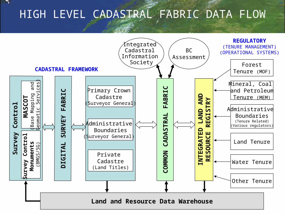
Su
rvey
Co
nt r
ol
Mineral, Coal and PetroleumTenure (MEM)
Administrative Boundaries(Tenure Related)
(Various regulators)
Land Tenure
Water Tenure
ForestTenure (MOF)
Land and Resource Data Warehouse
REGULATORY(TENURE MANAGEMENT)
(OPERATIONAL SYSTEMS)
CADASTRAL FRAMEWORKD
I GI T
AL
SU
RV
EY
FA
BR
I C
CO
MM
ON
CA
DA
ST
RA
L F
AB
RIC
INT
EG
RA
TE
D L
AN
D A
ND
R
ES
OU
RC
E R
EG
IST
RY
Other Tenure
BCAssessment
Integrated Cadastral
Information Society
HIGH LEVEL CADASTRAL FABRIC DATA FLOWS
urv
ey C
on
tro
l M
on
um
ents
(B
MG
S/S
G)
MA
SC
OT
(B
ase
Ma
pp
ing
an
d
Ge
om
atic
Se
rvic
es)
Primary Crown Cadastre
(Surveyor General)
Private Cadastre
(Land Titles)
Administrative Boundaries
(Surveyor General)
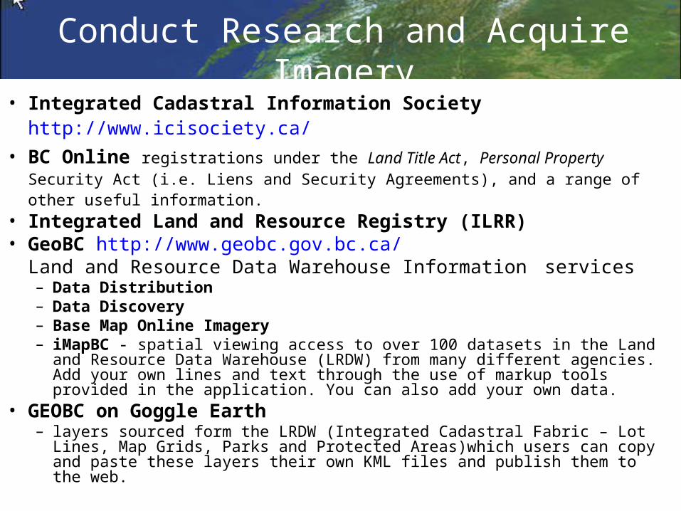
Conduct Research and Acquire Imagery
• Integrated Cadastral Information Society http://www.icisociety.ca/• BC Online registrations under the Land Title Act, Personal Property Security Act (i.e.
Liens and Security Agreements), and a range of other useful information.• Integrated Land and Resource Registry (ILRR) • GeoBC http://www.geobc.gov.bc.ca/
Land and Resource Data Warehouse Information services– Data Distribution – Data Discovery – Base Map Online Imagery– iMapBC - spatial viewing access to over 100 datasets in the Land and Resource Data
Warehouse (LRDW) from many different agencies. Add your own lines and text through the use of markup tools provided in the application. You can also add your own data.
• GEOBC on Goggle Earth – layers sourced form the LRDW (Integrated Cadastral Fabric – Lot Lines, Map Grids,
Parks and Protected Areas)which users can copy and paste these layers their own KML files and publish them to the web.
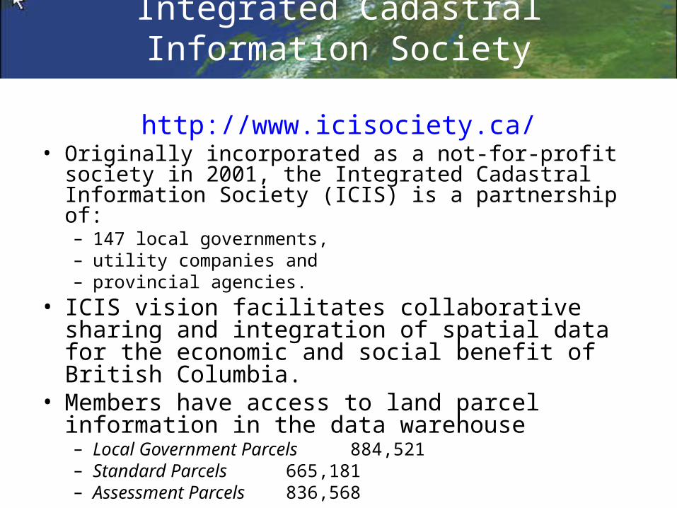
Integrated Cadastral Information Society
http://www.icisociety.ca/
• Originally incorporated as a not-for-profit society in 2001, the Integrated Cadastral Information Society (ICIS) is a partnership of:– 147 local governments, – utility companies and – provincial agencies.
• ICIS vision facilitates collaborative sharing and integration of spatial data for the economic and social benefit of British Columbia.
• Members have access to land parcel information in the data warehouse– Local Government Parcels 884,521– Standard Parcels 665,181– Assessment Parcels 836,568
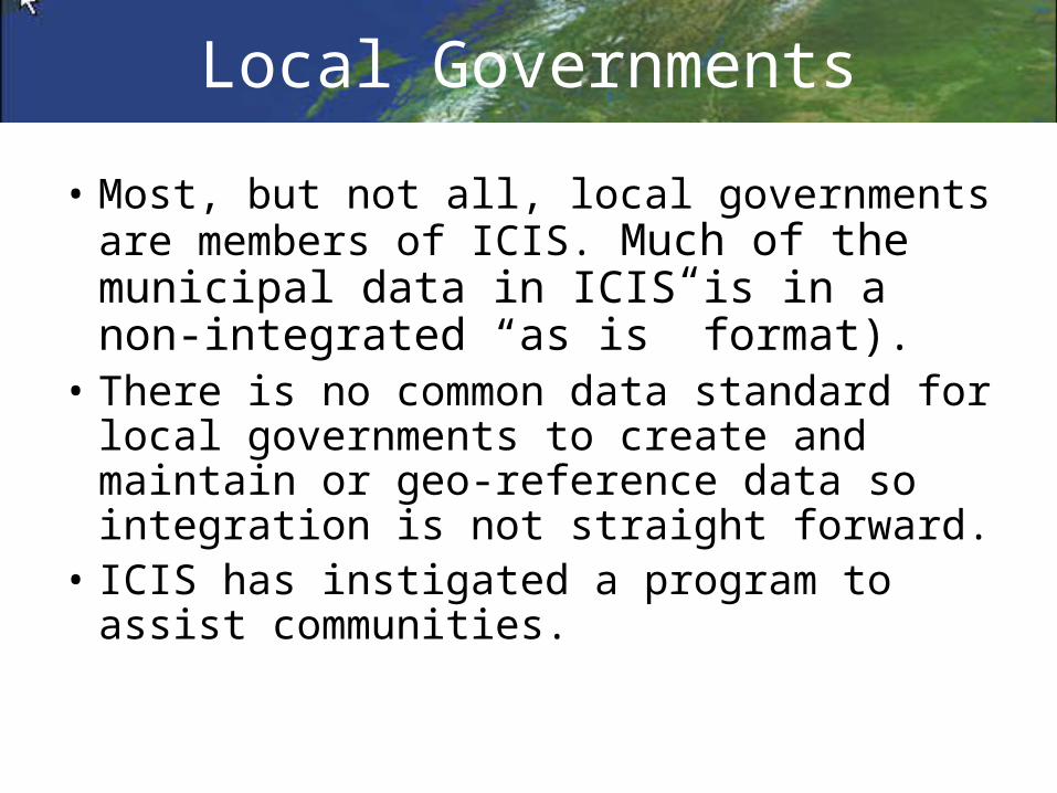
Local Governments
• Most, but not all, local governments are members of ICIS. Much of the municipal data in ICIS is in a non-integrated “as is” format).
• There is no common data standard for local governments to create and maintain or geo-reference data so integration is not straight forward.
• ICIS has instigated a program to assist communities.
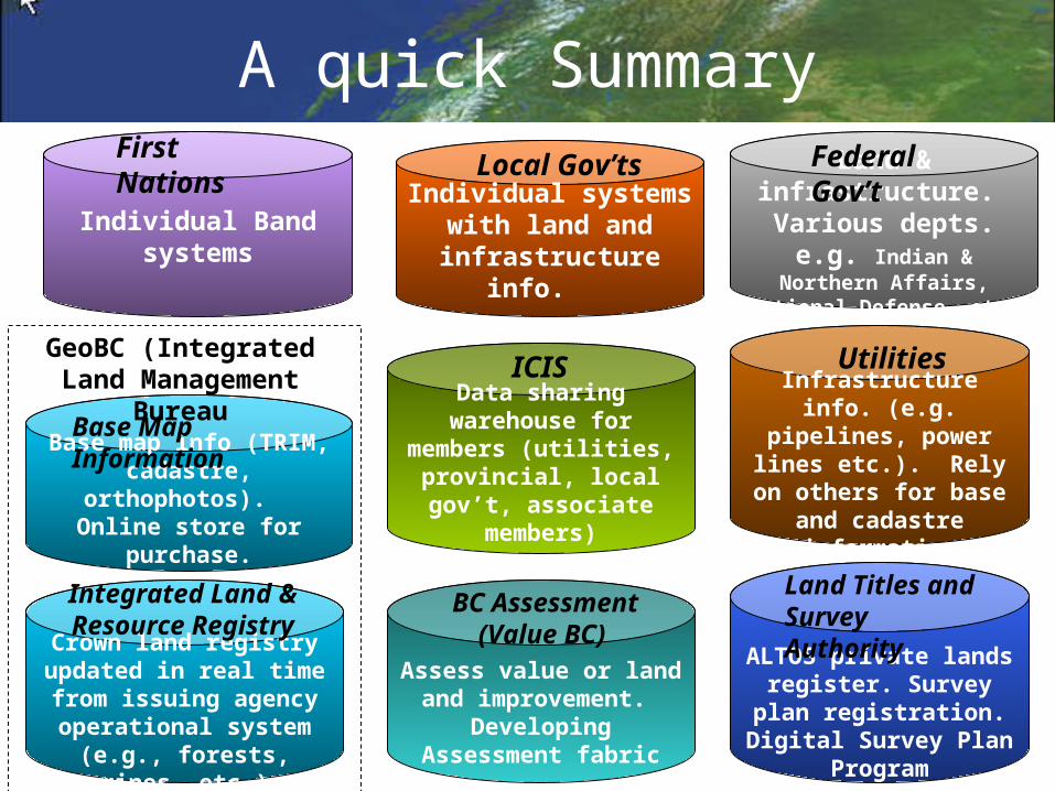
A quick Summary
Data sharing warehouse for members (utilities, provincial, local gov’t, associate members)
Assess value or land and improvement.
Developing Assessment fabric
ALTOS private lands register. Survey plan registration. Digital
Survey Plan Program
Land Titles and Survey AuthorityBC Assessment
(Value BC)
ICISInfrastructure info. (e.g. pipelines, power lines
etc.). Rely on others for base and cadastre
information
Utilities
Base map info (TRIM, cadastre, orthophotos).
Online store for purchase.
Base Map Information
Crown land registry updated in real time from
issuing agency operational system (e.g.,
forests, mines, etc.)
Integrated Land & Resource Registry
GeoBC (Integrated Land Management Bureau
Land & infrastructure. Various depts. e.g.
Indian & Northern Affairs, National Defense, etc.
Federal Gov’t
Individual Band systems
First Nations
Individual systems with land and
infrastructure info.
Local Gov’ts


![Cap. 116] Public Lands CHAPTER 116. PUBLIC LANDS.](https://static.fdocuments.in/doc/165x107/61f91a8ff1224d6b024ea0c9/cap-116-public-lands-chapter-116-public-lands.jpg)


![Effect of Rosa Mosqueta Husk Extract (Rosa rubiginosa) on ...downloads.hindawi.com/journals/jfq/2019/8464670.pdf · Rosa rubiginosa, Rosa moschata, and Rosa canina [1]. ‚e major](https://static.fdocuments.in/doc/165x107/5fb8267650a93f06e85281b9/effect-of-rosa-mosqueta-husk-extract-rosa-rubiginosa-on-rosa-rubiginosa-rosa.jpg)