
Presentazione standard di PowerPoint - COST Action...
28
Marco Dubbini [email protected] Alma Mater – University of Bologna Sec. Geography Mario Gattelli MAIA multispectral camera
Transcript of Presentazione standard di PowerPoint - COST Action...

Marco Dubbini
Alma Mater – University of Bologna Sec. Geography
Mario Gattelli
MAIAmultispectral camera

2
MAIA: The most advanced Multispectral Imaging Camerafor drones (UAVs), aircraft and land-vehicles available today
Photogrammetry-ready images in 8+3 VIS/NIR bands
Bands are very close to WorldView2 satellite
www.spectralcam.com

3
MAIA at a glance
Factory lens geometric calibration
8 bands cover the full VIS-NIR range + RGB
Plug-and-play for immediate use
Irradiance sensor with matched bandsfor reflectance measurements (patentpending - available soon)
Configuration and live image view over WiFi
Bundled scientific-grade image processing software
9x 1.2 Mpix sensorGlobal shutter12 bits
Rich set of interfacesand full access to anycamera setting forprecise control

4
Main applications
Agriculture• Precision farming• Vegetative index mapping• Water supply planning• Optimize pesticide use• Fertilization tuning• Yield estimation• Health condition
monitoring • Early detection of disease
Environmental monitoring andsurvey• Surface geology survey• Spill of pollutant or
hazardous substances• Biomass mapping
Industry• Remote chemical imaging• Large industrial plant
monitoring

5
Architecture and interfaces
Operator monitor
Radio controller
Operator
Aerial or ground platform
NMEA stings
WiFi
Ethernet
Radio Link
Gnssreceiver
OtherSynchro-
nizeddevices
Video Out
Trigger in
Strobe Out
CPU Control signals
Keypad
MAIA
Array of 9 synchronous
sensors
Geo tagged images
Accelerometer Gyroscope Gimbal
Control
USER interfaces
System interfaces
NMEA strings
Event

6
Plugs I

7
Plugs II
Nome Pin Signals Color Direction Logic Level Function
J1 - GigEthernet - - - -
J21 Power IN Red Pwr 9-26V
Power2 Power GND Nero Gnd -
J31 MPU SCL Giallo In TTL 3.3V
IMU/GYRO2 MPU SDA Blu In TTL 3.3V3 GND Nero Gnd -
J4
1 - Red Reserved -
-2 - Bianco Reserved -3 - Verde Reserved -4 - Nero Reserved -
J5
1 - Verde Reserved --
2 - Nero Reserved -3 CH1 Blu In TTL 3.3V
RADIO4 CH2 Giallo In TTL 3.3V5 RADIO GND Nero Gnd -
J6
1 Serial TX Verde Out TTL 3.3V/RS-232GNSS2 Serial RX Blu In TTL 3.3V/RS-232
3 Serial GND Nero Gnd -4 Trigger Giallo In TTL 3.3V
SYNC I/Os5 Strobe Verde Out TTL 3.3V6 GND Nero Gnd -
J7 - HDMI - - - -
8
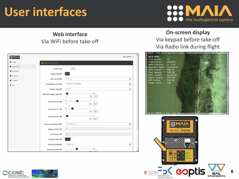
User interfaces
Web interfaceVia WiFi before take-off
On-screen displayVia keypad before take-offVia Radio link during flight

9
Camera features
Key technical specification Features and benefits
9 sensors: 1 RGB color + 8 bands in theVIS-NIR range (400-950nm).Bands are very close to WorldView2satellite.
An extensive band set covering the fullspectrum including 2 unique bands forpollution detection on water and soil +water supply planning.
1.2Mpix CMOS sensor (1280 x 960)Global shutterBest-in-class sensitivity8-10-12bits per pixel data depthSimultaneous shot of all sensors up to6fps at 8 bit (3fps at 10-12 bit)
Sharp and deeply detailed images withno motion artifacts even with fast UAVspeed.
Geometric factory-calibration of eachband.
Data ready for precise data analysis andphotogrammetric processing.
3cm ground sampling distance (GSD)45x34m2 field of view (FOV)at 75m flight altitude above ground.
Extremely detailed images with largearea coverage for cost-effective datacollection.
Preliminary
continued…

10
Camera features
Key technical specification Features and benefits
Full automatic or manual exposuremode, each sensor individuallytunable.
Total control of the exposureparameters for high-quality images.
Trigger input and strobe output syncsignals.
Precise timing control of the imageshot and sync of external devices.
250/500 GB (Solid Disk) internal storage capability.
5 hours of acquisition at 8bits, 1fps(1h at 3fps, 12bits).
Built-in WiFi and GigE interface withweb-based interface for configuration,live image view and access to storeddata.
Wireless on-field access viasmartphone, tablet or PC for imagestream and configuration. Fast cabledata download at home.
Input for external GNSS serial port withNMEA strings detection.
Accurate positioning of any image, forexample with RTK GNSS
Preliminary
continued…

11
Camera features
Key technical specification Features and benefits
Remote controller input with eventdetection.
Easy control of key parameters duringflight.
Wide supply input (9-26VDC) and lowpower consumption (~7,5W).
Compatible with all battery packagesand limited impact on battery life.
On-board 6-axis inertial unit withaccelerometer and gyroscope (IMU).
Effective image stabilization andseamless integration into body.Eulerian angles writings in log file foreach image.
Small size (99x128x46)mm3
Low weight (420g)Fits fixed-wings and multi-rotor UAVs,with limited impact on other payload.
Preliminary

12
Ground Sample Distance
DISTANCE
(m)
GSD(mm/px)
FOV
(mxm)
Max Speed
exp. time at 1ms
(m/s) – (km/h)
Motion Blur < 0.50px
50 23 30 x 23 11 - 40
75 35 45 x 34 17 - 61
100 47 60 x 45 23 - 83
150 70 90 x 68 35 - 126
350 165 210 x 157 >35 - >126
UAV
AIRCRAFT

13
UAV

14
Aircraft

15
Spectral bands
Band (nm) Approx. color
1 395-450 Violet (Coastal)
2 455-520 Blue
3 525-575 Green
4 580-625 Orange
5 630-690 Red
6 705-745 Red Edge
7 750-820 NIR1
8 825-950 NIR2
9 (VIS) (RGB)
The 8 bands of MAIA span the full VIS/NIR spectrum
Bands are very close to WorldView2 satellite
1 2 3
4
7
5
8
6
9

16
Spectral bands
Coastal areas and marine environmentUnaffected by atmospheric scattering
Reflectance peak for healty vegetationPlant classification
Plant classificationYellowing of foliage
Distinction between soil to vegetationUnaffected by atmospheric scattering
Absorbed by chlorophyllDetection of soil and geological features
Strongly depending on chlorophyll contentClassification of vegetationHealth status
Moisture content of biomass
Weak influence from atmosphereadditional info on biomass
Wavelength (nm)

17
Spectral bands
Band width on the central wavelength Indices coverage
Full width at half maximum
±20 nm
±15 nm±5 nm
NDVI3, NG, NR, NNIR, RVI, GRVI, DVI, GDVI, SAVI, GSAVI, GOSAVI, MSAVI2, GMSAVI2
SR2, DI1, OSAVI, RDVI, MSR, MSAVI, MTVI, MCARI2, CAI, NPQI, SR15, NDVI4
Greenness index (G), SR1, SR4, SR6, NDVI, GNDVI, PSSRa, NDI1, PRI, SRPI, NPCI, PSNDa, PSNDc, PSSRc, SR11, SR18, NDVI8
SR7, PSSRb, NDI2, SIPI, HNDVI, MTCI, PSNDb, VIopt2, SR8, SR12, SR13, SR17, Viopt1, RGR, NDVI6, NDVI7
Out of full width half band
SR3, SR5, NDI3, MCARI, TCARI, TVI, CARI, ZTM, mND705, mSR705, SR9, SR10, SR14, SR16, DD, R-M, G-M, ND705, PSRI, NDIV1, NDVI2, NDVI5, REIP
Considering the central wavelength of the eight bands, with a tolerance of ±5 nm 16%
of the indices can be properly computed; increasing the tolerance at ±15 nm or ±20 nm
the percentage raises respectively at 31% and 52% of the indices; considering the full
width at half maximum, 72% of the indices can be computed

18
MAIA/S Spectral bands
Bandwidth(nm)
Central Wavlength(nm)
1 20 443
2 65 490
3 35 560
4 30 665
5 15 705
6 15 740
7 20 783
8 115 842
9 20 865
Bands are the same to Sentinel2 satellite (VIS/NIR) 1 2 3
4
7
5
8
6
9
400 500 600 700 800 900
Wevlength (nm)
19
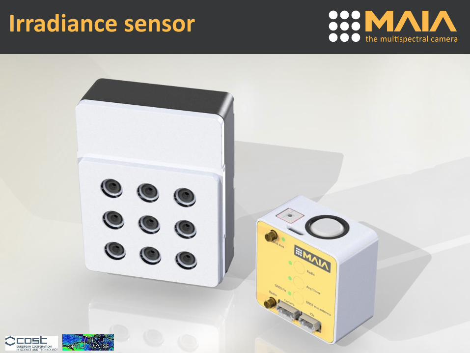
Irradiance sensor

20
Irradiance sensor
RTK correctionover LoRa radio link
GNSS signal
GNSS signal
Base station
Irradiance sensor• True reflectance measurement under
any light condition for each bandsindependently
• Integrated cm-level GNSS positioningwith Real Time Kinematics (L1 - RTK).
• Possibility to build wireless network ofbase stations for wide area coverage
Patent pending
BenefitsPixel-level geo-referenced andradiometric corrected imageswithout ground targets (very time-consuming task)
To be released in late Q2.2017

21
Analysis flow 1/3
Multispectral aerial survey of the area of
interest
Image undistortionand co-registration
8+3 pixel-to-pixel matching layers
8+3 layers with several geometrical “imperfections”
Images acquired by the camera
Factory-calibration geometric data+
Parameters extracted from the images
!

22
Analysis flow 2/3
3D model and geo-referenced
orthophoto
Radiometric correction
Performed by MAIA softwareOptional step, third-party software required
Digital numbers proportional to light hitting the target
Reflectance values of the target
23
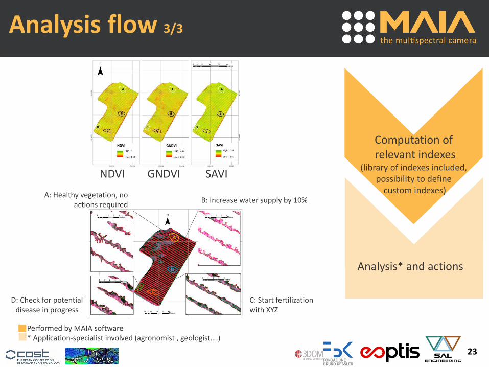
Analysis flow 3/3
Analysis* and actions
Computation ofrelevant indexes
(library of indexes included, possibility to define
custom indexes)B: Increase water supply by 10%
C: Start fertilization with XYZ
D: Check for potential disease in progress
A: Healthy vegetation, no actions required
Performed by MAIA software* Application-specialist involved (agronomist , geologist….)
NDVI GNDVI SAVI

24
Software GUI
Powerful processing and uniquefeatures designed for users withoutbackground in photogrammetry.

25
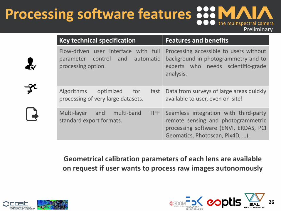
Processing software features
Key technical specification Features and benefits
Image un-distortion and co-registrationwith factory-calibration data andcontext-sensitive analysis.
Perfect overlapping of the multi-bandsimages, with sub-pixel accuracy andundistorted images
3-modes radiometric correction for thebands: automatic, with reflectancetarget, or with irradiance sensor data.Automatic radial radiometric correction(vignetting).
Accurate reflectance values forquantitative analysis.
Index computation and false-colorimage generation with standardindexes of included library (NDVI,GNDVI, SAVI, …) and indexes defined byuser at will.
Ready-to-use data for widespreadanalysis and flexibility to explore newapplication-specific indexes.
Preview of raw images and false-colorindex images.
Immediate availability of relevantinformation.
Preliminary
continued…
26
Processing software features
Key technical specification Features and benefits
Flow-driven user interface with fullparameter control and automaticprocessing option.
Processing accessible to users withoutbackground in photogrammetry and toexperts who needs scientific-gradeanalysis.
Algorithms optimized for fastprocessing of very large datasets.
Data from surveys of large areas quicklyavailable to user, even on-site!
Multi-layer and multi-band TIFFstandard export formats.
Seamless integration with third-partyremote sensing and photogrammetricprocessing software (ENVI, ERDAS, PCIGeomatics, Photoscan, Pix4D, …).
Preliminary
Geometrical calibration parameters of each lens are available on request if user wants to process raw images autonomously

27
Conference and Paper
International Conference on Agricultural Engineering. CIGRAgEng 2016. Aarhus, Denmark 26 – 29
http://conferences.au.dk/uploads/tx_powermail/marinello_multispectral.pdf
Agricultural Engineering International: CIGR Journal
Last generation instrument for agriculture multispectral data collection
Marco Dubbini a, Francesco Marinello b,*, Andrea Pezzuolo b, Michaela De Giglio c, Mario Gattelli d, Daniele Covi e
a University of Bologna – Sec. Geography, Bologna, Italy b Department of Land, Environment, Agriculture and Forestry, University of Padova, Legnaro, Padova, Italy
c Department of Civil, Chemical, Environmental and Materials Engineering, University of Bologna, Bologna, Italyd SAL Engineering srl, Modena, Italy
e Eoptis srl, Trento, Italy
In press

Marco Dubbini
Alma Mater – University of Bologna Sec. Geography
Mario Gattelli
MAIAmultispectral camera