Present-day shortening in Southern Haiti from GPS...
8
Present-day shortening in Southern Haiti from GPS measurements and implications for seismic hazard Steeve Symithe a , Eric Calais b, ⁎ a Purdue University, Dept. of Earth and Atmospheric Science, West Lafayette, IN, USA b Ecole normale supérieure, Dept. of Geosciences, PSL Research University, Paris, France abstract article info Article history: Received 14 February 2016 Received in revised form 20 April 2016 Accepted 22 April 2016 Available online 29 April 2016 The ~3 M inhabitant capital region of Haiti, severely affected by the devastating January 12, 2010, M7.0 earthquake, continues to expand at a fast rate. Accurate characterization of regional earthquake sources is key to inform urban development and construction practices through improved regional seismic hazard estimates. Here we use a recently updated Global Positioning System (GPS) data set to show that seismogenic strain accumulation in southern Haiti involves an overlooked component of shortening on a south-dipping reverse fault along the southern edge of the Cul-de-Sac basin, in addition to the well-known component of left-lateral strike-slip motion. This tectonic model implies that ground shaking may be twice that expected if the major fault was purely strike-slip, as assumed in the current seismic hazard map for the region. © 2016 Elsevier B.V. All rights reserved. Keywords: GPS Geodesy Haiti Active tectonics Earthquake hazard 1. Introduction On January 12, 2010, Haiti was struck by a devastating – though not unexpected – earthquake (Bilham, 2010)(Fig. 1). Because its epicenter was located in the near vicinity of the Enriquillo Plaintain Garden Fault (EPGF), a major active fault part of the left-lateral strike-slip boundary between the Caribbean and North American plates (Fig. 1), it was first thought that the event had ruptured a portion of the strike-slip EPGF. In- dependent studies based on geodetic (Calais et al., 2010; Hayes et al., 2010; Hashimoto et al., 2011; Mercier de Lépinay et al., 2011; Symithe et al., 2013), geological (Prentice et al., 2010), and seismological data (Douilly et al., 2013) showed that the earthquake had actually ruptured a previously unmapped fault with a source mechanism combining strike-slip and reverse faulting, in a setting resembling the 1989 Loma Prieta earthquake in California (e.g., Dietz and Ellsworth, 1990; Beroza, 1991). This composite source mechanism was a first indication that the conventional interpretation of the EPGF in southern Haiti as a purely strike-slip fault system may need revisiting. GPS measurements in the northeastern Caribbean have established that the 19 mm/yr relative motion between the Caribbean and North American plates, slightly oblique to the plate boundary direction in His- paniola, is accommodated by shortening on the North Hispaniola fault to the north and strike-slip motion on the ~E–W striking Septentrional and Enriquillo faults throughout the island (Calais et al. (2002), Manaker et al. (2008), Fig. 1). Further geodetic studies making use a larger number of geodetic sites identified an additional component of boundary–normal shortening in southern Haiti (Calais et al., 2010; Benford et al., 2012; Symithe et al., 2015), consistent with the composite source mechanism of the 2010 earthquake but, again, questioning the purely strike-slip nature of the EPGF system in the region (Mann et al., 1995). Here, we revisit the present-day tectonic setting of southern Haiti by testing published tectonic models in light of geodetic data acquired since the 2010 earthquake. We show that the well-known strike-slip motion affecting the area is accompanied by an even larger component of shortening on a south-dipping reverse fault along the southern edge of the Cul-de-Sac basin, which holds the ~3 M people capital city of Port-au-Prince. This tectonic scenario implies that ground shaking may be twice that expected if the major fault was purely strike-slip, as assumed in the current seismic hazard map for the region. 2. Tectonic setting The EPGF has long been recognized as a major tectonic feature of southern Haiti, where it was first named “Linéament Tiburon-Pétionville” from the eponymous end-points of its surface trace mapped using airphoto interpretation (Duplan, 1975), then “Décrochement Sénestre Sud Haïtien” (Calmus, 1983). Subsequent studies however tended to minimize its importance as an active plate boundary fault. The EPGF does not appear as a major feature on the 250,000th Haiti geological maps (Momplaisir and Boisson, 1988). Pubellier et al. (1991) proposed that slip on the EPGF stopped in the Late Miocene when deformation in southern Hispaniola became compressional as the Haiti fold-and-thrust belt (Fig. 1) was propagating southward to its present position with its Tectonophysics 679 (2016) 117–124 ⁎ Corresponding author at: Ecole normale supérieure, Dept. of Geosciences, 24 rue Lhomond, 75005 Paris, France. E-mail address: [email protected] (E. Calais). http://dx.doi.org/10.1016/j.tecto.2016.04.034 0040-1951/© 2016 Elsevier B.V. All rights reserved. Contents lists available at ScienceDirect Tectonophysics journal homepage: www.elsevier.com/locate/tecto
Transcript of Present-day shortening in Southern Haiti from GPS...

Tectonophysics 679 (2016) 117–124
Contents lists available at ScienceDirect
Tectonophysics
j ourna l homepage: www.e lsev ie r .com/ locate / tecto
Present-day shortening in Southern Haiti from GPS measurements andimplications for seismic hazard
Steeve Symithe a, Eric Calais b,⁎a Purdue University, Dept. of Earth and Atmospheric Science, West Lafayette, IN, USAb Ecole normale supérieure, Dept. of Geosciences, PSL Research University, Paris, France
⁎ Corresponding author at: Ecole normale supérieureLhomond, 75005 Paris, France.
E-mail address: [email protected] (E. Calais).
http://dx.doi.org/10.1016/j.tecto.2016.04.0340040-1951/© 2016 Elsevier B.V. All rights reserved.
a b s t r a c t
a r t i c l e i n f oArticle history:Received 14 February 2016Received in revised form 20 April 2016Accepted 22 April 2016Available online 29 April 2016
The ~3 M inhabitant capital region of Haiti, severely affected by the devastating January 12, 2010, M7.0earthquake, continues to expand at a fast rate. Accurate characterization of regional earthquake sources is keyto inform urban development and construction practices through improved regional seismic hazard estimates.Here we use a recently updated Global Positioning System (GPS) data set to show that seismogenic strainaccumulation in southern Haiti involves an overlooked component of shortening on a south-dipping reversefault along the southern edge of the Cul-de-Sac basin, in addition to the well-known component of left-lateralstrike-slip motion. This tectonic model implies that ground shaking may be twice that expected if the majorfault was purely strike-slip, as assumed in the current seismic hazard map for the region.
© 2016 Elsevier B.V. All rights reserved.
Keywords:GPS GeodesyHaitiActive tectonicsEarthquake hazard
1. Introduction
On January 12, 2010, Haiti was struck by a devastating – though notunexpected – earthquake (Bilham, 2010) (Fig. 1). Because its epicenterwas located in the near vicinity of the Enriquillo Plaintain Garden Fault(EPGF), a major active fault part of the left-lateral strike-slip boundarybetween the Caribbean and North American plates (Fig. 1), it was firstthought that the event had ruptured a portion of the strike-slip EPGF. In-dependent studies based on geodetic (Calais et al., 2010; Hayes et al.,2010; Hashimoto et al., 2011; Mercier de Lépinay et al., 2011; Symitheet al., 2013), geological (Prentice et al., 2010), and seismological data(Douilly et al., 2013) showed that the earthquake had actually ruptureda previously unmapped fault with a source mechanism combiningstrike-slip and reverse faulting, in a setting resembling the 1989 LomaPrieta earthquake in California (e.g., Dietz and Ellsworth, 1990; Beroza,1991). This composite source mechanism was a first indication thatthe conventional interpretation of the EPGF in southern Haiti as a purelystrike-slip fault system may need revisiting.
GPS measurements in the northeastern Caribbean have establishedthat the 19 mm/yr relative motion between the Caribbean and NorthAmerican plates, slightly oblique to the plate boundary direction in His-paniola, is accommodated by shortening on the North Hispaniola faultto the north and strike-slip motion on the ~E–W striking Septentrionaland Enriquillo faults throughout the island (Calais et al. (2002),Manaker et al. (2008), Fig. 1). Further geodetic studies making use a
, Dept. of Geosciences, 24 rue
larger number of geodetic sites identified an additional component ofboundary–normal shortening in southern Haiti (Calais et al., 2010;Benford et al., 2012; Symithe et al., 2015), consistentwith the compositesource mechanism of the 2010 earthquake but, again, questioning thepurely strike-slip nature of the EPGF system in the region (Mann et al.,1995).
Here, we revisit the present-day tectonic setting of southernHaiti bytesting published tectonic models in light of geodetic data acquiredsince the 2010 earthquake. We show that the well-known strike-slipmotion affecting the area is accompanied by an even larger componentof shortening on a south-dipping reverse fault along the southernedge of the Cul-de-Sac basin, which holds the ~3 M people capital cityof Port-au-Prince. This tectonic scenario implies that ground shakingmay be twice that expected if the major fault was purely strike-slip, asassumed in the current seismic hazard map for the region.
2. Tectonic setting
The EPGF has long been recognized as a major tectonic feature ofsouthern Haiti, where it was first named “Linéament Tiburon-Pétionville”from the eponymous end-points of its surface trace mapped usingairphoto interpretation (Duplan, 1975), then “Décrochement SénestreSud Haïtien” (Calmus, 1983). Subsequent studies however tended tominimize its importance as an active plate boundary fault. The EPGFdoes not appear as a major feature on the 250,000th Haiti geologicalmaps (Momplaisir and Boisson, 1988). Pubellier et al. (1991) proposedthat slip on the EPGF stopped in the Late Miocene when deformation insouthern Hispaniola became compressional as the Haiti fold-and-thrustbelt (Fig. 1) was propagating southward to its present position with its
Caribbean
South AmericaCocos
Nazca
N. America2
2
5
7
2
Caribbean Plate
1887
1751a1751b
2010
1842
1562
1867
1690
1843
1918
2003
1953 1946
17851787
17011770
North American Plate
1974
Bahama Platform
EPGF
Trough
SFRico Trench
Muertos
Puerto
AnegadaP.Rico
CubaNHF
Haiti
Dom. Rep.
19 mm/yr
Fig. 1. Current tectonic setting of the northeastern Caribbean. SF = Septentrional fault, EPGF = Enriquillo Plantain Garden Fault. Stars show large (Mb7) instrumental and historicalearthquakes. Red rectangle shows the area displayed on Fig. 2.
118 S. Symithe, E. Calais / Tectonophysics 679 (2016) 117–124
active front currently thrusting onto the Cul-de-Sac basin along theNeiba–Matheux range. In their view, the EPGZ was reactivated as anormal fault in the Quaternary as a result of crustal loading impartedby the fold-and-thrust belt to the north (Pubellier et al., 2000).
Mann et al. (1995) proposed a drastically different interpretationwhere the EPGF is a quasi-vertical, left-lateral, active strike-slip faultrunning across southern Hispaniola from the westernmost tip of Haitito the Enriquillo basin in the Dominican Republic. The fault is indeedwell-marked in the morphology throughout the southern Peninsula ofHaiti as a quasi-linear feature with push-ups and pull-aparts (Calmus,1983; Momplaisir, 1986). This holds until about 72.27 W near the cityof Pétionville where the EPGF intersects the Cul-de-Sac plain (Fig. 2).East of that point, its imprint on the morphology becomes more subtle.Mann et al. (1995) describe a series of gentle folds affecting plio-quaternary sediments along the southern edge of the Cul-de-Sac basinand into the Enriquillo basin in the Dominican Republic that theyinterpret as en échelon drag folds marking the trace of EPGF (Fig. 2A).The Cabritos island in the Enriquillo lake is the easternmost of thesefolds and, in that interpretation, is the surface expression of a verticalEPGF at depth. Hence, most of the recent maps show the EPGF as asingle – though segmented – left-lateral strike-slip fault extendingfrom Jamaica to the west all the way through southern Haiti and intothe Enriquillo basin in the Dominican Republic to the east.
This interpretation contrasts with early geologic work in southernHaiti where the EPGF, well expressed along the Southern Peninsula, ismapped as abutting against a north-verging reverse fault system thatmark the southern edge of the Cul-de-Sac basin (Fig. 2B, Bourgueilet al., 1988). Recent geological surveys of the Port-au-Prince area sup-port this interpretation and show that these N110 E reverse-sinistralfaults affect Quaternary alluvial sediments throughout the city and tothe east (Terrier et al., 2014). At a broader regional scale, Saint Fleuret al. (2015) used high-resolution air photos and lidar topography torevisit the plio-quaternary folds identified by Mann et al. (1995) alongthe southern edge of the Cul-de-Sac basin. They propose that they arefault-propagation folds on top of shallow-dipping decollementsemerging well into the Cul-de-Sac basin and rooted on a south-dippinglow-angle reverse fault underneath the high relief Massif de la Selle(Fig. 2B). In their interpretation, the Cul-de-Sac basin is activelyoverthrusted on both sides by the Matheux–Neiba range in the northand the Massif de la Selle in the south while the EPGF is a young(b2 Ma) fault propagating eastward throughout southern Haiti.
3. GPS data
Weuse GPS data acquired in Haiti and the Dominican Republic since2003 to test the tectonic models described above, determine the geom-etry of themajor active faults in southern Haiti, and quantify the relatedelastic strain accumulation to inform regional hazard assessment. GPSdata acquisition and processing procedures are provided in Symitheet al. (2013). The solution used here is an improved sub-sample oftheir data set that includes additional GPS measurements collected inHaiti and the Dominican Republic from June 2014 to April 2015. As aresult, we now have a dense distribution of GPS sites covering thewhole island, in particular the southern part of Haiti.
The regional velocityfield (Fig. 3) shows left-lateralmotion betweenthe Caribbean and North American plates at 17–19 mm/yr, slightlyoblique to the plate boundary direction. Velocities in Hispaniola showa north–south gradient with up to 15 mm/yr of integrated left-lateralshear strain across the island, consistent with previous findings(Symithe et al., 2015). A new observation, however, is a component ofboundary–normal shortening readily visible on Fig. 3. This shorteningaffects the central and western parts of Hispaniola, except the SouthernPeninsula of Haiti west of 72.5Wwhere velocities in a Caribbean frameare parallel to the E–W-trending EPGF (Calais et al., 2016).
This shortening component, that adds to the well-known regionalleft-lateral shear, is readily visible on the profile displayed on Fig. 3where we project the GPS velocities onto directions parallel and normalto the EPGF strike. We observe a well-defined velocity gradient, both inthe shortening and strike-slip components, coincident with the contactbetween the Cul-de-Sac basin and the Massif de la Selle. Althoughstrike-slip motion at about 6–7 mm/yr was expected (Manaker et al.,2008; Benford et al., 2012; Symithe et al., 2015), the significant compo-nent of shortening visible on the profiles had not been documentedbefore. In the following, our objective is to determine the geometry ofthe fault system that accommodates the observed strike-slip and short-ening localized along the southern edge of the Cul-de-Sac basin.
4. Elastic model
We implement a simplemodelwhere faults are simulated as rectan-gular dislocations in an elastic half-space.We follow the classically-usedbackslip approach of Savage (1983) and calculate surface deformationdue to faults locked in the upper, seismogenic, crust as the difference
−72.8˚
−72.6˚
−72.4˚
−72.2˚
−72.0˚
−71.8˚
−71.6˚
18.2˚
18.4˚
18.6˚
18.8˚
Matheux
NeibaGonaveCul-de-Sac
Cabritos Is.
Bahoruco
Massif de la Selle
PaPL
J
EnriquilloPV
−72.8˚
−72.6˚
−72.4˚
−72.2˚
−72.0˚
−71.8˚
−71.6˚
18.2˚
18.4˚
18.6˚
18.8˚
Matheux
NeibaGonaveCul-de-Sac
Cabritos Is.
Bahoruco
Massif de la Selle
2680 m
PaPL
J
EnriquilloPV
A
B
T N
J GD
Hai
tiD
om. R
ep.
Hai
tiD
om. R
ep.
Azuei
Azuei
2680 m
Fig. 2. Comparison of tectonic interpretations of the eastern termination of the Enriquillo fault system. A. Following (Mann et al., 1995), where the Enriquillo fault is a continuous, vertical,strike-slip fault associated with minor en échelon drag folds. B. Following Saint Fleur et al. (2015), where the Enriquillo fault abuts against an oblique-slip fault system with fold-propagation folding well into the Cul-de-Sac basin. T = Tabarre, N = Nan Cadastre, D = Dumay, J = Jacquet, G = Ganthier.
119S. Symithe, E. Calais / Tectonophysics 679 (2016) 117–124
between the deformation caused by an infinitely wide fault plane withuniform slip from the surface downward and the deformation causedby a fault plane with uniform slip across a finite width. We relate faultslip to surface motion using the Green's functions of Okada (1992) forrectangular dislocations assuming uniform slip and dip angle.
In the “one-fault”models, surface deformation is caused by uniformslip on a fault whose dip is varied from 5 to 90, surface trace locationfrom 18.4 to 18.9 latitude, and strike from 70 E to 110 E. In the “two-fault” models, we test whether strike- and dip-slip motion may bepartitioned on two different, nearby faults. These fault geometries areobviously simplifications of the actual geology, as GPS measurementsare rarely able to capture the details of fault plane geometries, even inregions where dense networks and ample geological data are available(e.g., Argus, 2005). Because the density of GPS sites is not sufficient tocapture the short wavelengths of the strain rate field, our models aretherefore meant to reproduce the average behavior of a fault systemwhose geometry is likely to be more complex in actuality.
In order to score the models, we only consider GPS sites that are notaffected by fault systems other than the Enriquillo–Cul-de-Sac basin. Wemodel a N–S profile that originates just south of Haiti at longitude 72Wand latitude 17.8 N. We run and score a series of models with profilelengths extending northward from 100 km – i.e., to the southern edgeof the Neiba-Matheuxmountains – to 200 km— i.e., encompassing addi-tional sites in northern Haiti close to the Septentrional fault (Fig. 5A). As
expected, model misfit increases with profile length as more data isincluded, but with a significant jump at 180 km profile length, wheresites start being significantly affected by elastic strain accumulation onthe Septentional and North Hispaniola faults.
We also run and score a series of models where we vary the profilewidth to determine reasonable eastern and western bounds for the setof sites to include. We seek to encompass a region where lateralvariations in fault geometry and tectonic regime are negligible so thatour two-dimensional models hold, while still including as many GPSsites as possible in the analysis. We find that model misfit increasessignificantly for profile widths of 58 km and larger (Fig. 5B). We there-fore select, for the sake of this analysis, GPS sites located inside the175 km-long by 58 km-wide box shown on Fig. 3.
The model is two-dimensional, though we acknowledge that thestudy area is not perfectly cylindrical — for instance the EPGF changesdirection around 72.27W, as described above. Fig. 5 however showsthat all the sites we are using to constrain the models are consistentwith a two-dimensional approach. The model used here thereforeprovides us with a first-order estimate of the active fault geometry atwork and allows us to gain new insight into the regional tectonics. A3-dimensional model will eventually become necessary as our under-standing of the local geology allows us to build better-constrainedgeometries and as the GPS data become more dense, in particularalong the southern edge of the Cul-de-Sac basin.

−74 −73 −72 −71 −70 −69
18
19
20
10 mm/yr
18
19
20
Caribbean frame
North America frame
10 mm/yr
A
B
C
strike-slip
shortening
150
100
50
0
Dep
th (
km)
100 150 200 250Distance (km)
A B
seismicity(all Hispaniola)
18
0
4
8
12
16
Vel
ocity
(m
m/y
r)
0 50
MS
CdS
MN
EF SF
PC
PN
EF
SF
EF
SF
NORTHSOUTH
Fig. 3. GPS velocities shown with respect to the North American plate (A) and to the Caribbean plate (B). Error ellipses are 95% confidence. (C) North–south profile including GPS sitesshown with the dashed box shown on panels A and B. Velocities are projected onto directions parallel (blue) and normal (red) to the EPGF direction. MS = Massif de la Selle, CdS =Cul-de-Sac basin, MN= Matheux-Neiba range, PC = Plateau Central, PN = Plaine du Nord, EF = Enriquillo fault, SF = Septentrional fault.
0
2
4
6
-2
0
2
4
6
8
10
0
200 6040
Str
ike-
slip
(m
m/y
r)S
hort
enin
g (m
m/y
r)
Distance (km)
Dep
th (
km)
Cul-de-SacMatheux
Massif de la Selle
GD
+.
Cretaceous basalts
Miocene-Pliocene
Paleocene-Eocene
N S
Fig. 4. Top and middle: comparison between the best-fit model (solid lines) and GPSobservations for the strike-slip (blue) and shortening (red) components for the one–fault model, i.e. with oblique slip on the south-dipping fault. Bottom: interpretativegeological cross-section using information from Saint Fleur et al. (2015). The red lineindicates the model fault with its locked portion shown as solid. The surface trace of thefault in the best-fit model coincides with the northern limb of the Ganthier fold,indicated by the letter G. The gradient of GPS velocities coincides with the southernedge of the Cul-de-Sac basin, while the Matheux range appears devoid from present-daystrain accumulation. D = Dumay locale where Terrier et al. (2014) report reversefaulting affecting Quaternary sediments. G = Ganthier fold (Mann et al., 1995).
120 S. Symithe, E. Calais / Tectonophysics 679 (2016) 117–124
In order to optimally search the parameter space and determinereliable uncertainties associated with the estimated parameters, wemake use of Bayes' rule (Segall, 2002; Johnson, 2004;Hilley et al., 2005):
P mi xjð Þ ¼ Pðx miÞj �P mið ÞXPðx miÞj �P mj
� � ð1Þ
where mi is a vector of four unknown parameters (slip, dip, lockingdepth, and fault location), x is a set of observed GPS velocities, P(mi |x)is the probability of parameter set mi to explain the observed data setx, and P(mi) is some prior probability that this model parameter set ac-tually occurs derived from independent information. P(x |mi) is theprobability of observing x as interseismic surface deformation whenthemodel parameter ismi. Sincewe haveminimuma priori informationon the estimated parameters, we use a uniform distribution as prior forall parameters P(mi) over intervals 0–20 mm/an for slip rates, 0–90 fordip angle, and 2–15 km for locking depth. In order to optimally evaluateEq. (1), we use a Metropolis–Hastings sampling method which uses aMarkov Chain with stationary distribution (Metropolis et al., 1953).
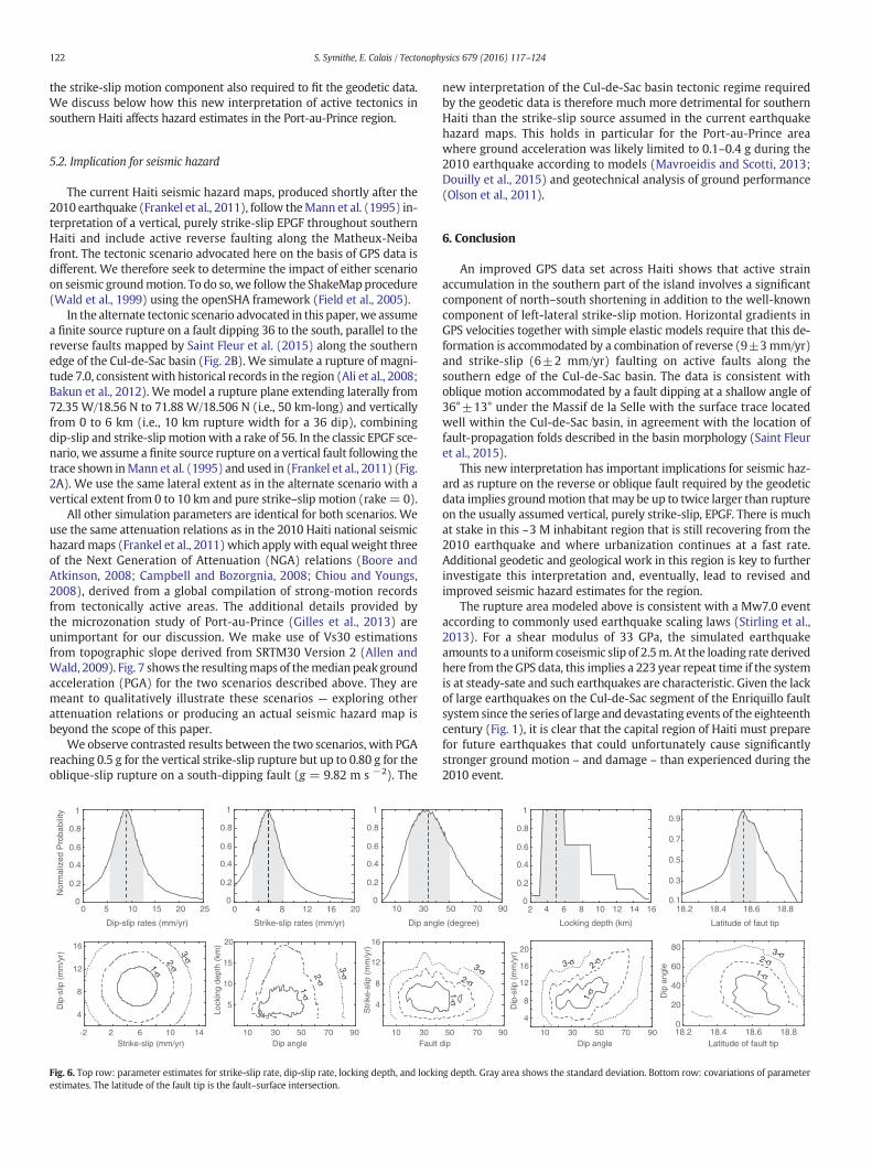
The best-fit model in the one-fault configuration, shown on Fig. 4, isobtained for a fault–surface intersection at 18.55 latitude, with a dip of36±13 to the south underneath the Massif de la Selle, and a lockingdepth of 8±4 km (Table 1). It is remarkable that the inferred locationof the fault–surface intersection coincides precisely with the southerntoe of the fault-propagating folds identified by Saint Fleur et al.(2015), for instance the Ganthier fold (Fig. 4, bottom panel). Themodel scores a χ2 of 69.92 with WRMS of 1.3 mm/yr and 0.8 mm/yrfor the E–WandN–S components of the GPS velocities, respectively. Pa-rameters inferred from the Bayesian analysis, their uncertainties, andtheir covariance are shown on Fig. 6. We observe that inferred parame-ters are well determined from the data, which favor a south-dippingfault with oblique slip whose tip crops out within the Cul-de-Sac basin.
Table 1Estimated model parameters and associated uncertainties (one-fault model).
Estimated Parameters Average Optimum Std. deviation
Strike–slip rate (mm/yr) 5.7 6.0 2.4Dip–slip rate (mm/yr) 8.9 9.0 2.8Dip angle (°) 37.0 36.0 13.0Locking depth (km) 5.3 6.3 3.5
121S. Symithe, E. Calais / Tectonophysics 679 (2016) 117–124
We also tested a two-fault model where deformation is partitionedonto (1) pure dip-slip motion on the best-fit shallow-dip reverse faultdetermined above, and (2) pure strike-slip motion on a vertical fault lo-cated at the contact between theMassif de la Selle and Cul-de-Sac basin,i.e., the usually assumed EPGF fault geometry. The best-fit slip rates are6 mm/yr and 9 mm/yr for the strike-slip and reverse faults, similar tothe one-fault model. This model scores a χ2 of 78.62 with WRMS of1.3 mm/yr and 0.8 mm/yr for the E–W and N–S components of theGPS velocities, respectively. Decreasing the dip of the strike-slip faultsystematically increases the misfit (WRMS = 1.35 mm/yr and χ2 =85.88 for a 70 dip). Therefore, although partitioning slip on two faultsslightly increases the model misfit compared to the one-fault model,the overall fit remains reasonable. However, the data still requires a sig-nificant amount of dip-slip motion on a shallow, south–dipping reversefault with a surface trace located well within the Cul-de-Sac basin.
5. Discussion
5.1. Present-day tectonic model
The modeling of the GPS velocities described above allows us toidentify oblique slip on a reverse, south-dipping fault along the southernedge of the Cul-de-Sac basin, with dip-slip exceeding strike-slip veloci-ties. The geodetic data support elastic strain accumulation on a locked,shallow-angle fault dipping southward underneath the Massif de laSelle and accommodating a combination of 9 ±3 mm/yr of reversemotion and 6±2 mm/yr of strike-slip motion. It is readily apparent onFig. 4 that the GPS data do not indicate significant deformation alongthe Neiba–Matheux front at the precision level of the measurements,about 1 mm/yr. We now discuss how this new result fits the geologicalframework, starting from the broader regional scale.
Plate boundary deformation in southern Hispaniola is currentlyaccommodated by a combination of plate boundary-parallel strike slipmotion that appears to decrease from west to east and plate boundary-normal shortening that decreases from west to east (Fig. 3). West ofPort-au-Prince, the GPS velocities imply that deformation is partitionedbetween strike-slip on the EPGF along the Southern Peninsula of Haiti
Distance along profile (km)100 120 140 160 180 200
2.0
4.0
6.0
8.0
220
RM
S (
mm
/yr)
Fig. 5.Model χ2 as a function of profile length and width. This serves to determine the GPS sitewhich the two-dimensionalfault models used here hold.
and shortening across the Gulf of Gonave. This is consistent with seismicsurveys that have long shown a series of active folds and reverse faultsalong the northern coast of the Southern Peninsula and across theGonave Gulf, the Gonave Island itself being one of these anticlinal folds(Goreau, 1981; Bruneton et al., 1988;Momplaisir, 1986). One of these re-verse faults, the Trois Baies fault, was the locus of triggered seismicitywith purely reverse focal mechanisms in the wake of the 2010 Haitiearthquake (Douilly et al., 2013).
The reverse faulting required by the GPS data along the southernedge of the Cul-de-Sac basin is consistent with geological observationsof active folding (Mann et al., 1995; Terrier et al., 2014) and with thegeological interpretation that the Massif de la Selle is actively thrustingover the Cul-de-Sac basin (Bourgueil et al., 1988; Saint Fleur et al.,2015). It remains possible that the strike-slip component is accommo-dated by an additional, EPGF-type vertical fault, different but close tothe reverse fault required by the data. However, the configurationwhere a strike-slip and a dip-slip fault would intersect at depth doesnot appear to be mechanically stable — it is difficult to imagine howthe two faults would coexist over the long term unless one of themhas a very low slip rate, which is not the case with dip-slip and strike-slip components of 9 and 6 mm/yr, respectively.
In addition, the existence of a vertical strike-slip fault along thesouthern edge of the Cul-de-Sac basin remains elusive, while there isdirect field evidence for reverse faulting in Quaternary alluvial depositsthroughout Port-au-Prince (Terrier et al., 2014) and just to the east ofthe city at the Dumay locale (Saint Fleur et al., 2015). These recentobservations are consistent with an early geologic map of Haiti wherethe southern edge of the Cul-de-Sac basin is a north-verging reversefault system intersecting the EPGF just east of Port-au-Prince(Bourgueil et al., 1988).
The interpretation of a vertical EPGF continuous throughout the Cul-de-Sac basin owes toMann et al.'s (1995) reproduction of a seismic lineacross the Enriquillo Lake (MOBIL LINE 1127) in the Dominican Repub-lic where recent faulting just north of the Cabritos Island anticline isinterpreted as the trace of the EPGF. However, seismic reflectorsbelow about 1.5 s on this profile arewell-marked and continuous acrossit, indicating that surface faulting does not continue vertically at depth.This points to an alternative interpretation where the Cabritos anticlinemay be unrelated to the EPGF, but rather be a fault-propagation folddeveloping above a shallow decollement rooted to the south on asouth-dipping reverse fault underneath the Selle-Bahoruco Massif,similar to the interpretation of the Cul-de-Sac folds by Saint Fleur et al.(2015).
We therefore conclude that the geodetic and geological informationcurrently available are consistentwith significant present-day shorteningcoincident with the southern edge of the Cul-de-Sac basin, in addition to
Width of Profile (km)40 45 50 55 60 65 70 75 80
2.5
3.0
3.5
4.0
4.5
5.0
s that are not affected by fault systems other than the Enriquillo-Cul-de-Sac basin and for
122 S. Symithe, E. Calais / Tectonophysics 679 (2016) 117–124
the strike-slip motion component also required to fit the geodetic data.We discuss below how this new interpretation of active tectonics insouthern Haiti affects hazard estimates in the Port-au-Prince region.
5.2. Implication for seismic hazard
The current Haiti seismic hazard maps, produced shortly after the2010 earthquake (Frankel et al., 2011), follow theMann et al. (1995) in-terpretation of a vertical, purely strike-slip EPGF throughout southernHaiti and include active reverse faulting along the Matheux-Neibafront. The tectonic scenario advocated here on the basis of GPS data isdifferent. We therefore seek to determine the impact of either scenarioon seismic groundmotion. To do so, we follow the ShakeMapprocedure(Wald et al., 1999) using the openSHA framework (Field et al., 2005).
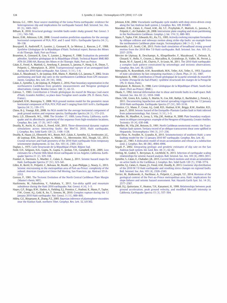
In the alternate tectonic scenario advocated in this paper, we assumea finite source rupture on a fault dipping 36 to the south, parallel to thereverse faults mapped by Saint Fleur et al. (2015) along the southernedge of the Cul-de-Sac basin (Fig. 2B). We simulate a rupture of magni-tude 7.0, consistent with historical records in the region (Ali et al., 2008;Bakun et al., 2012). We model a rupture plane extending laterally from72.35 W/18.56 N to 71.88 W/18.506 N (i.e., 50 km-long) and verticallyfrom 0 to 6 km (i.e., 10 km rupture width for a 36 dip), combiningdip-slip and strike-slip motion with a rake of 56. In the classic EPGF sce-nario, we assume a finite source rupture on a vertical fault following thetrace shown inMann et al. (1995) and used in (Frankel et al., 2011) (Fig.2A). We use the same lateral extent as in the alternate scenario with avertical extent from 0 to 10 km and pure strike–slip motion (rake= 0).
All other simulation parameters are identical for both scenarios. Weuse the same attenuation relations as in the 2010 Haiti national seismichazardmaps (Frankel et al., 2011) which apply with equal weight threeof the Next Generation of Attenuation (NGA) relations (Boore andAtkinson, 2008; Campbell and Bozorgnia, 2008; Chiou and Youngs,2008), derived from a global compilation of strong-motion recordsfrom tectonically active areas. The additional details provided bythe microzonation study of Port-au-Prince (Gilles et al., 2013) areunimportant for our discussion. We make use of Vs30 estimationsfrom topographic slope derived from SRTM30 Version 2 (Allen andWald, 2009). Fig. 7 shows the resultingmaps of themedianpeak groundacceleration (PGA) for the two scenarios described above. They aremeant to qualitatively illustrate these scenarios — exploring otherattenuation relations or producing an actual seismic hazard map isbeyond the scope of this paper.
We observe contrasted results between the two scenarios, with PGAreaching 0.5 g for the vertical strike-slip rupture but up to 0.80 g for theoblique-slip rupture on a south-dipping fault (g = 9.82 m s −2). The
10 15 20 25
Dip-slip rates (mm/yr)
Nor
mal
ized
Pro
babi
lity
0
0.2
0.4
0.6
0.8
1
50
Dip angl
301012 16 200 4 8
Strike-slip rates (mm/yr)
-2 10 14
4
8
12
16
Strike-slip (mm/yr)
Dip
-slip
(m
m/y
r)
62 90
5
10
15
20
Dip angle
Lock
ing
dept
h (k
m)
70503010
4
8
12
16
Fault
Str
ike-
slip
(m
m/y
r)
3010
0
0.2
0.4
0.6
0.8
1
0
0.2
0.4
0.6
0.8
1
1-σ2-σ
3-σ
1-σ2-σ
3-σ
Fig. 6. Top row: parameter estimates for strike-slip rate, dip-slip rate, locking depth, and lockinestimates. The latitude of the fault tip is the fault–surface intersection.
new interpretation of the Cul-de-Sac basin tectonic regime requiredby the geodetic data is therefore much more detrimental for southernHaiti than the strike-slip source assumed in the current earthquakehazard maps. This holds in particular for the Port-au-Prince areawhere ground acceleration was likely limited to 0.1–0.4 g during the2010 earthquake according to models (Mavroeidis and Scotti, 2013;Douilly et al., 2015) and geotechnical analysis of ground performance(Olson et al., 2011).
6. Conclusion
An improved GPS data set across Haiti shows that active strainaccumulation in the southern part of the island involves a significantcomponent of north–south shortening in addition to the well-knowncomponent of left-lateral strike-slip motion. Horizontal gradients inGPS velocities together with simple elastic models require that this de-formation is accommodated by a combination of reverse (9±3mm/yr)and strike-slip (6±2 mm/yr) faulting on active faults along thesouthern edge of the Cul-de-Sac basin. The data is consistent withoblique motion accommodated by a fault dipping at a shallow angle of36°±13° under the Massif de la Selle with the surface trace locatedwell within the Cul-de-Sac basin, in agreement with the location offault-propagation folds described in the basin morphology (Saint Fleuret al., 2015).
This new interpretation has important implications for seismic haz-ard as rupture on the reverse or oblique fault required by the geodeticdata implies groundmotion that may be up to twice larger than ruptureon the usually assumed vertical, purely strike-slip, EPGF. There is muchat stake in this ~3 M inhabitant region that is still recovering from the2010 earthquake and where urbanization continues at a fast rate.Additional geodetic and geological work in this region is key to furtherinvestigate this interpretation and, eventually, lead to revised andimproved seismic hazard estimates for the region.
The rupture area modeled above is consistent with a Mw7.0 eventaccording to commonly used earthquake scaling laws (Stirling et al.,2013). For a shear modulus of 33 GPa, the simulated earthquakeamounts to a uniform coseismic slip of 2.5m. At the loading rate derivedhere from theGPS data, this implies a 223 year repeat time if the systemis at steady-sate and such earthquakes are characteristic. Given the lackof large earthquakes on the Cul-de-Sac segment of the Enriquillo faultsystem since the series of large and devastating events of the eighteenthcentury (Fig. 1), it is clear that the capital region of Haiti must preparefor future earthquakes that could unfortunately cause significantlystronger ground motion – and damage – than experienced during the2010 event.
90
e (degree)
7050 10 12 14 16
Locking depth (km)
4 6 82
dip907050
4
8
12
16
20
Dip angle
Dip
-slip
(m
m/y
r)
9070503010
0
0.2
0.4
0.6
0.8
1
1-σ
2-σ
3-σ
1-σ
2-σ3-σ
18.2 18.4 18.6 18.80.1
0.3
0.5
0.7
0.9
18.2 18.4 18.6 18.80
20
40
60
80
Latitude of faut tip
Dip
ang
le
Latitude of fault tip
1-σ
2-σ3-σ
g depth. Gray area shows the standard deviation. Bottom row: covariations of parameter

0.1
0.1
0.1
0.2
0.2
0.2
0.3
0.3
0.4
0.4
0.5
0.5
0.60.6
0.7Carrefour
Jacmel
Kenscoff
0.1
0.1
0.2
0.2
0.2
0.3
0.3
0.4
0.4
0.5Carrefour
Jacmel
Mirebalais Lascahobas
Port−au−Prince D
PV
Jacmel
Petit Goave
Mirebalais
Leogane
CdB
LascahobasAnse−a−Galets
M7, oblique-slip
−72.8˚ −72.4˚ −72.0˚ −71.6˚
18.4˚ 18.4˚
18.8˚ 18.8˚
MMI I II−III IV VI VII VIII IX X+
Damage None None None Very light Light Moderate Mod./heavy Heavy Very heavy
Felt Not felt Weak Light Moderate Strong Very strong Severe Violent Extreme
PGA (%g) <0.17 0.17−1.4 1.4−3.9 3.9−9.2 9.2−18 18−34 34−65 65−124 >124
PGV (cm/s) <0.1 0.1−1.1 1.1−3.4 3.4−8.1 8.1−16 16−31 31−60 60−116 >116
Port−au−Prince D
PV
Jacmel
Petit Goave
Leogane
CdB
Anse−a−Galets
Kenscoff
M7, strike-slip
−72.8˚ −72.4˚ −72.0˚ −71.6˚
18.4˚ 18.4˚
18.8˚ 18.8˚
V
Fig. 7.Groundmotion scenarios illustrating the two end-membermodels discussed in the text. Thick black lines show the surface projection of the simulated rupture, of magnitude 7.0 inboth cases. Solid contours show PGA in g. Background colors showmodified Mercalli intensities calculated according toWald et al. (1999). CdB= Croix des Bouquets, D= Delmas, PV=Pétionville.
123S. Symithe, E. Calais / Tectonophysics 679 (2016) 117–124
Acknowledgments
The campaign GPS data used in this study were collected as part ofthe “CANAPE” (CAribbean North America Plate Experiment) projectwith support from the Direccion General de Mineria, the InstitutoCartografico Militar, the Colegio Dominicano de Ingenieros, Arquitectosy Agrimensores (CoDIA), and Holasa S.A. in the Dominican Republic andfrom the Bureau desMines et de l'Energie, the Direction de la ProtectionCivile, the CentreNational de l'InformationGéo-Spatiale, and the Facultédes Sciences de l'Université d'Etat in Haiti.We used all publicly availablecontinuous data from various providers, in particular the “COCONet”(Continuously Operating Caribbean Observation Network, coconet.unavco.org) international initiative and the U.S. “CORS” network (Contin-uously Operating Reference Stations geodesy.noaa.gov/CORS/. We thankN. Saint Fleur, N. Feuillet, and Y. Klinger for sharing geological informationand interpretation ahead of publication. We thank K. Vanneste andT. Camelbeeck for taking the time to double-check our ground motioncalculations. This work benefited from insightful discussions with B. de
Lépinay. We thank reviewers P. Vernant and R. Bilham, as well as editorR. Govers for their constructive comments. This research was supportedby a COCONet fellowship from UNAVCO (EAR-1042906/EAR-1042909)to SJS and National Science Foundation awards EAR-0409487, EAR-RAPID-1024990, and EAR-1045809 to EC.
References
Ali, S.T., Freed, A.M., Calais, E., Manaker, D.M., McCann, W.R., 2008. Coulomb stress evolu-tion in Northeastern Caribbean over the past 250 years due to coseismic, postseismicand interseismic deformation. Geophys. J. Int. 174 (3), 904–918.
Allen, T.I., Wald, D.J., 2009. On the use of high-resolution topographic data as a proxy forseismic site conditions (VS30). Bull. Seismol. Soc. Am. 99 (2A), 935–943.
Argus, D.F., 2005. Interseismic strain accumulation and anthropogenic motion inmetropolitan Los Angeles. J. Geophys. Res. 110, B04401.
Bakun, W.H., Flores, C.H., U. S. ten Brink, 2012. Significant earthquakes on the EnriquilloFault System, Hispaniola, 1500–2010: implications for seismic hazard. Bull. Seismol.Soc. Am. 102 (1), 18–30.
Benford, B., DeMets, C., Calais, E., 2012. GPS estimates of microplate motions, northernCaribbean: evidence for a Hispaniola microplate and implications for earthquakehazard. Geophys. J. Int. 191 (2), 481–490.
124 S. Symithe, E. Calais / Tectonophysics 679 (2016) 117–124
Beroza, G.C., 1991. Near-source modeling of the Loma Prieta earthquake: evidence forheterogeneous slip and implications for earthquake hazard. Bull. Seismol. Soc. Am.81 (5), 1603–1621.
Bilham, R., 2010. Structural geology: invisible faults under shaky ground. Nat. Geosci. 3(11), 743–745.
Boore, D.M., Atkinson, G.M., 2008. Ground-motion prediction equations for the averagehorizontal component of PGA, PGV, and 5 sand 10.0 s. Earthquake Spectra 24 (1),99–138.
Bourgueil, B., Andreieff, P., Lasnier, J., Gonnard, R., Le Metour, J., Rancon, J.-P., 1988.Synthèse Géologique de la République d’Haiti. Technical report, Bureau des Mineset de l'Energie. Haiti, Port-au-Prince.
Bruneton, A., Gonnard, R., Gou, Y., Lasnier, J., Negroni, P., 1988. Evaluation du potentielpétrolier, Synthèse géologique de la République d’Haiti. Technical Report BME/BIDATN-SA 2506-HA, Bureau des Mines et de l’Energie. Haiti, Port-au-Prince.
Calais, E., Freed, A., Mattioli, G., Amelung, F., Jonsson, S., Jansma, P., Hong, S.-H., Dixon, T.,Prépetit, C., Momplaisir, R., 2010. Transpressional rupture of an unmapped faultduring the 2010 Haiti earthquake. Nat. Geosci. 3 (11), 1–6.
Calais, E., Mazabraud, Y., de Lepinay, B.M., Mann, P., Mattioli, G.S., Jansma, P., 2002. Strainpartitioning and fault slip rates in the northeastern Caribbean from GPS measure-ments. Geophys. Res. Lett. 29 (18), 1856.
Calais, E., Symithe, S., de Lépinay, B., Prépetit, C., 2016. Plate boundary segmentation in thenortheastern Caribbean from geodetic measurements and Neogene geologicalobservations. Compt. Rendus Geosci. 348 (1), 42–51.
Calmus, T., 1983. Contribution à l'étude géologique du massif de Macaya (sud-ouestd’Haiti, Grandes Antilles), sa place dans l’orogène nord caraibe (Ph. D. thesis, Paris,France).
Campbell, K.W., Bozorgnia, Y., 2008. NGA ground motion model for the geometric meanhorizontal component of PGA, PGV, PGD and 5 ranging from 0.01 to10 s. EarthquakeSpectra 24 (1), 139–171.
Chiou, B.-J., Youngs, R.R., 2008. An NGA model for the average horizontal component ofpeak ground motion and response spectra. Earthquake Spectra 24 (1), 173–215.
Dietz, L.D., Ellsworth, W.L., 1990. The October 17, 1989, Loma Prieta, California, earth-quake and its aftershocks: geometry of the sequence from high-resolution locations.Geophys. Res. Lett. 17 (9), 1417–1420.
Douilly, R., Aochi, H., Calais, E., Freed, A.M., 2015. Three-dimensional dynamic rupturesimulations across interacting faults: the Mw7.0, 2010, Haiti earthquake.J. Geophys. Res. Solid Earth 120 (2), 1108–1128.
Douilly, R., Haase, J.S., Ellsworth, W.L., Bouin, M.P., Calais, E., Symithe, S.J., Armbruster, J.G.,de Lepinay, B.M., Deschamps, A., Mildor, S.L., Meremonte, M.E., Hough, S.E., 2013.Crustal structure and Fault geometry of the 2010 Haiti earthquake from temporaryseismometer deployments. ol. Soc. Am. 103 (4), 2305–2325.
Duplan, L., 1975. Carte Structurale de la République d'Haiti. Région Sud.Field, E.H., Seligson, H.A., Gupta, N., Gupta, V., Jordan, T.H., Campbell, K.W., 2005. Loss
estimates for a Puente Hills blind-thrust earthquake in Los Angeles, California. Earth-quake Spectra 21 (2), 329–338.
Frankel, A., Harmsen, S., Mueller, C., Calais, E., Haase, J., 2011. Seismic hazard maps forHaiti. Earthquake Spectra 27 (S1), S23–S41.
Gilles, R., Bertil, D., Prépetit, C., Belvaux, M., Roullé, A., Jean-Philippe, J., Noury, G., 2013.Seismic microzoning in the metropolitan area of Port-au-Prince: complexity of thesubsoil. American Geophysical Union Fall Meeting, San Francisco, pp. Abstract S51A–2312.
Goreau, P., 1981. The Tectonic Evolution of the North Central Caribbean Plate Margin(Master's thesis, MIT).
Hashimoto, M., Fukushima, Y., Fukahata, Y., 2011. Fan-delta uplift and mountainsubsidence during the Haiti 2010 earthquake. Nat. Geosci. 4 (4), 1–5.
Hayes, G.P., Briggs, R.W., Sladen, A., Fielding, E.J., Prentice, C., Hudnut, K., Mann, P., Taylor,F.W., Crone, A.J., Gold, R., Ito, T., Simons, M., 2010. Complex rupture during the 12January 2010 Haiti earthquake. Nat. Geosci. 3 (11), 800–805.
Hilley, G.E., Bürgmann, R., Zhang, P.Z., 2005. Bayesian inference of plastosphere viscositiesnear the Kunlun Fault, northern Tibet. Geophys. Res. Lett. 32, L01302.
Johnson, K.M., 2004. Viscoelastic earthquake cycle models with deep stress-driven creepalong the San Andreas fault system. J. Geophys. Res. 109, B10403.
Manaker, D.M., Calais, E., Freed, A.M., Ali, S.T., Przybylski, P., Mattioli, G., Jansma, P.,Prépetit, C., de Chabalier, J.B., 2008. Interseismic plate coupling and strain partitioningin the Northeastern Caribbean. Geophys. J. Int. 174 (3), 889–903.
Mann, P., Taylor, F.W., Edwards, R.L., Ku, T.L., 1995. Actively evolvingmicroplate formationby oblique collision and sideways motion along strike-slip faults: an example fromthe northeastern Caribbean plate margin. Tectonophysics 246 (1–3), 1–69.
Mavroeidis, G.P., Scotti, C.M., 2013. Finite-fault simulation of broadband strong groundmotion from the 2010 Mw 7.0 Haiti earthquake. Bull. Seismol. Soc. Am. 103 (5),2557–2576.
Mercier de Lépinay, B., Deschamps, A., Klingelhoefer, F., Mazabraud, Y., Delouis, B.,Clouard, V., Hello, Y., Crozon, J., Marcaillou, B., Graindorge, D., Vallée, M., Perrot, J.,Bouin, M.-P., Saurel, J.-M., Charvis, P., St-Louis, M., 2011. The 2010 Haiti earthquake:a complex fault pattern constrained by seismologic and tectonic observations.Geophys. Res. Lett. 38, L22305.
Metropolis, N., Rosenbluth, A.W., Rosenbluth, M.N., Teller, A.H., Teller, E., 1953. Equationof state calculations by fast computing machines. J. Chem. Phys. 21 (6), 1087.
Momplaisir, R., 1986. Contribution à l’étude géologique de la partie orientale dumassif dela Hotte (Presqu’ile du Sud d’Haiti): synthèse structurale des marges de la Presqu’ile(Ph. D. thesis, Paris).
Momplaisir, R., Boisson, D., 1988. Carte Géologique de la République d’Haiti, South-Eastsheet (Port-au-Prince) (BME.).
Okada, Y., 1992. Internal deformation due to shear and tensile faults in a half-space. Bull.Seismol. Soc. Am. 82 (2), 1018–1040.
Olson, S.M., Green, R.A., Lasley, S., Martin, N., Cox, B.R., Rathje, E., Bachhuber, J., French, J.,2011. Documenting liquefaction and lateral spreading triggered by the 12 January2010 Haiti earthquake. Earthquake Spectra 27 (S1), S93–S116.
Prentice, C.S., Mann, P., Crone, A.J., Gold, R.D., Hudnut, K.W., Briggs, R.W., Koehler, R.D.,Jean, P., 2010. Seismic hazard of the Enriquillo–Plantain Garden fault in Haiti inferredfrom palaeoseismology. Nat. Geosci. 3 (11), 1–5.
Pubellier, M., Mauffret, A., Leroy, S., Vila, J.M., Amilcar, H., 2000. Plate boundary readjust-ment in oblique convergence: example of the Neogene of Hispaniola, Greater Antilles.Tectonics 19 (4), 630–648.
Pubellier, M., Vila, J.M., Boisson, D., 1991. North Caribbean neotectonic events: the Trans-Haitian fault system. Tertiary record of an oblique transcurrent shear zone uplifted inHispaniola. Tectonophysics 194 (3), 217–236.
Saint Fleur, N., Feuillet, N., Grandin, R., 2015. Seismotectonics of southern Haiti: a newfaulting model for the 12 January 2010 M7 earthquake. Geophys. Res. Lett. 42.
Savage, J.C., 1983. A dislocation model of strain accumulation and release at a subductionzone. J. Geophys. Res. 88 (B6), 4984–4996.
Segall, P., 2002. Integrating geologic and geodetic estimates of slip rate on the SanAndreas fault system. Int. Geol. Rev. 44 (1), 62–82.
Stirling, M., Goded, T., Berryman, K., Litchfield, N., 2013. Selection of earthquake scalingrelationships for seismic-hazard analysis. Bull. Seismol. Soc. Am. 103 (6), 2993–3011.
Symithe, S., Calais, E., Chabalier, J.B., 2015. Current block motions and strain accumulationon active faults in the Caribbean. J. Geophys. Res. Solid Earth 120 (5), 3748–3774.
Symithe, S.J., Calais, E., Haase, J.S., Freed, A.M., Douilly, R., 2013. Coseismic slip distributionof the 2010 M 7.0 Haiti earthquake and resulting stress changes on regional faults.Bull. Seismol. Soc. Am. 103 (4), 2326–2343.
Terrier, M., Bialkowski, A., Nachbaur, A., Prépetit, C., Joseph, Y.F., 2014. Revision of thegeological context of the Port-au-Prince metropolitan area, Haiti: implications forslope failures and seismic hazard assessment. Nat. Hazards Earth Syst. Sci. 14 (9),2577–2587.
Wald, D.J., Quitoriano, V., Heaton, T.H., Kanamori, H., 1999. Relationships between peakground acceleration, peak ground velocity, and modified Mercalli intensity inCalifornia. Earthquake Spectra 15 (3), 557–564.