Seismic risks assessment around the Mediterranean region Dr ...
Present and future climate risks in
Montenegro
Sanja Pavicevic, MSc PhysicsInstitute of Hydrometeorology and Seismology of Montenegro
Workshop „Climate Change Adaptation“ City Hotel, Crnogorskih serdara 5 Podgorica, Montenegro
31 October – 1 November 20131

Content
• Climate change key players in MNE
• Country profile: geographic and demographic
• Climate of MNE and climate trends
• Natural hazards: geological and hydrometeorological
• Natural Hazards Vulnerability Facts and Trends
• Conclusions
2

Administrative organization in the area of
climate change in Montenegro
3
The Ministry of Sustainable Development and Tourism (MSDT) has key competencies in the area of Climate Change.
The Ministry designs policies and adopts relevant regulations.
Environmental Protection Agency (EPA), as an executive authority, plays a significant role in implementing the climate change policy.
Institute of Hydrometeorology and Seismology (IHMS) monitors climate and potential impacts of climate change on different sectors of the economy and natural resources and develops climate scenarios.
IHS also acts as the focal point of Montenegro in the Intergovernmental Panel on Climate Change (IPCC) and the Global Climate Observing System (GCOS), WMO, IHO, EUMETNET, ECMWF, EUMETSAT.

4
Address: IV proleterske 1981000 PodgoricaMontenegro
www.meteo.co.me
www.epa.org.me
www.mrt.gov.me
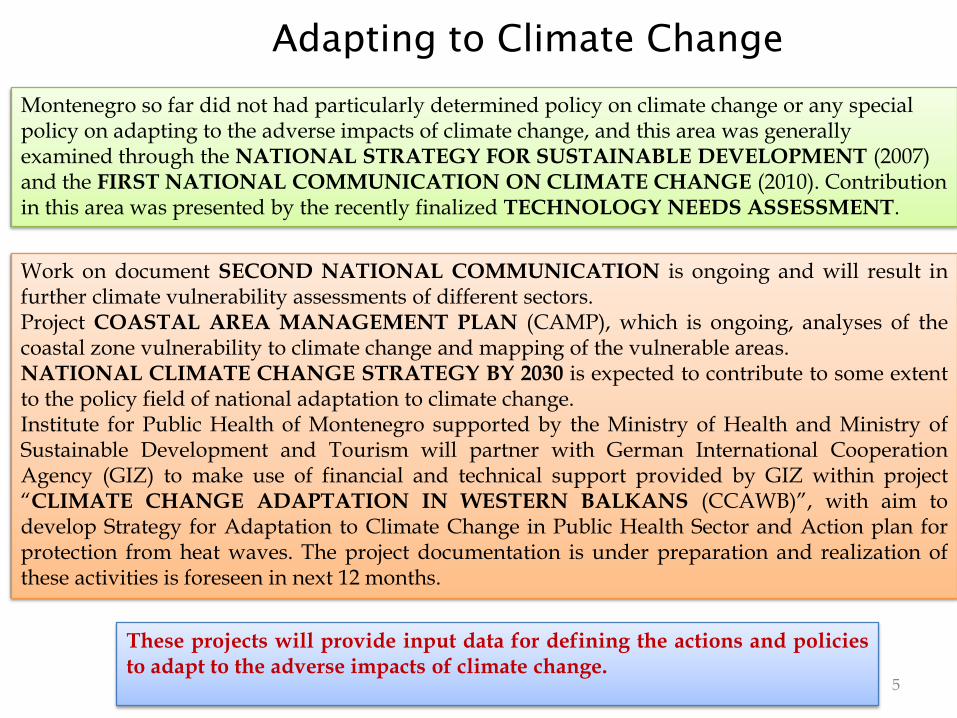
Adapting to Climate Change
These projects will provide input data for defining the actions and policiesto adapt to the adverse impacts of climate change.
5
Montenegro so far did not had particularly determined policy on climate change or any special policy on adapting to the adverse impacts of climate change, and this area was generally examined through the NATIONAL STRATEGY FOR SUSTAINABLE DEVELOPMENT (2007) and the FIRST NATIONAL COMMUNICATION ON CLIMATE CHANGE (2010). Contribution in this area was presented by the recently finalized TECHNOLOGY NEEDS ASSESSMENT.
Work on document SECOND NATIONAL COMMUNICATION is ongoing and will result infurther climate vulnerability assessments of different sectors.Project COASTAL AREA MANAGEMENT PLAN (CAMP), which is ongoing, analyses of thecoastal zone vulnerability to climate change and mapping of the vulnerable areas.NATIONAL CLIMATE CHANGE STRATEGY BY 2030 is expected to contribute to some extentto the policy field of national adaptation to climate change.Institute for Public Health of Montenegro supported by the Ministry of Health and Ministry ofSustainable Development and Tourism will partner with German International CooperationAgency (GIZ) to make use of financial and technical support provided by GIZ within project“CLIMATE CHANGE ADAPTATION IN WESTERN BALKANS (CCAWB)”, with aim todevelop Strategy for Adaptation to Climate Change in Public Health Sector and Action plan forprotection from heat waves. The project documentation is under preparation and realization ofthese activities is foreseen in next 12 months.

MONTENEGRIN CLIMATE CHANGE PUBLICATIONS
6

GEOGRAPHIC PROFILE
• Montenegro is an Adriatic-Mediterranean, Dinaric, South East European country. It is located between 41°39' and 43°32' latitude and 18°26' and 20°21' longitude. The sea coast is 293 km long.
• The surface of Montenegro is 13 812 km2, and sea bed is 2 540 km2.
• According to the 2003 census, Montenegro has 620 145 inhabitants, which makes for the population density of 44.8 inhabitants per 1 km2.
7

DEMOGRAPHIC PROFILE
Migration balance for Montenegrin municipalities in 2010
• Regional differences hinders thecountry’s economic growth.
• Rural area has demographicallyaged, since its biologicalsubstance is in danger and it iseconomically poorer.
• Urbanization has progressed,mostly in the central part ofMontenegro, even in thesouthern.
• There is a significant differencein the scope of poverty in thenorthern region and other partsof the country
8
Poverty in Montenegro between 2008 and 2010

9
Climate of Montenegro
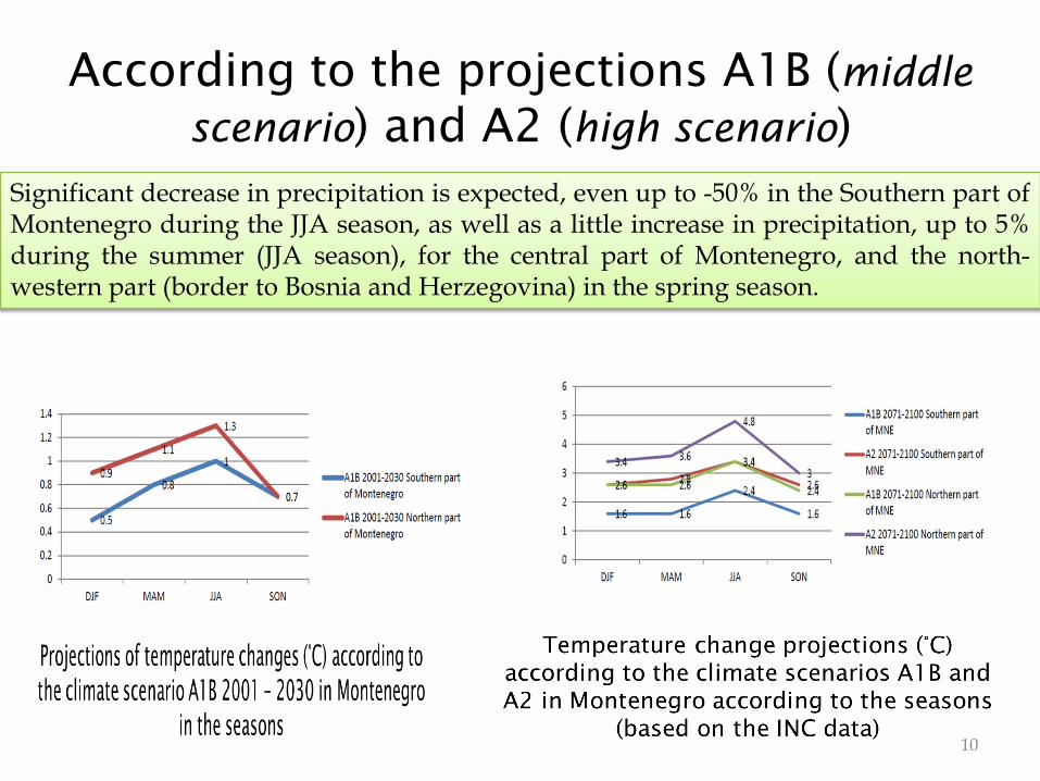
According to the projections A1B (middle
scenario) and A2 (high scenario)
10
Significant decrease in precipitation is expected, even up to -50% in the Southern part ofMontenegro during the JJA season, as well as a little increase in precipitation, up to 5%during the summer (JJA season), for the central part of Montenegro, and the north-western part (border to Bosnia and Herzegovina) in the spring season.

Hazard and risk
• According to the UNISDR terminology on DRR:Risk is combination of the probability of an event and its negative consequences:
RISK = Hazard Impact x Probability of occurrence
• According to the Risk Assessment and Mapping Guidelines, for Disaster Management, developed by European Commission:
RISK = f (P * e * v)
• P - PROBABILITY, • e - EXPOSURE PEOPLE AND PROPERTY IN HAZARD ZONES AND • v - VULNERABILITY
11
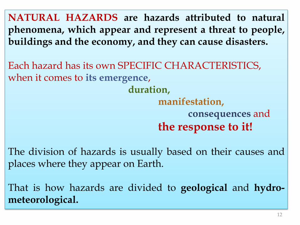
NATURAL HAZARDS are hazards attributed to naturalphenomena, which appear and represent a threat to people,buildings and the economy, and they can cause disasters.
Each hazard has its own SPECIFIC CHARACTERISTICS,when it comes to its emergence,
duration,manifestation,
consequences and
the response to it!
The division of hazards is usually based on their causes andplaces where they appear on Earth.
That is how hazards are divided to geological and hydro-meteorological.
12

Geological hazards are reflected through the internalprocesses in Earth, such as earthquakes and volcanoeruptions, or the external processes, such as landslides.
Tsunami, as an ocean process, belongs to the so calledhazard of coastal water and they are activated by seaearthquakes and other geological events.
13

Hydro-meteorological hazards are most often weather dependent phenomena (floods, extreme temperatures – heat and cold waves – droughts, soil desertification, avalanches and hurricanes)
It is important to understand that NATURAL HAZARDS CAN CAUSE ONE ANOTHER, e.g. storms cause floods, earthquakes can cause tsunamis and landslides, a volcano eruption can cause fires.
14

Expect significant
seismicity intensification
In terms of the planned largeinvestments, when it comes tothe projected accumulations onthe river Morača, it is realisticto expect significant seismicityintensification in the zone ofthose accumulations and theirimmediate surroundings,especially after the first filling ofthe accumulations.
In case of accumulations on theriver Moraca, that level is 5.5units of the Richter scale.
Seismic reyonization map of Montenegro with the position of the
existing and planned energy facilities (Source: IHMS) 15

The change in seismicity character (red) compared to the total accumulation
volume (blue), in the southern Dinaride during the last 70 years (Source: Seismology Institute of
Montenegro)
It has definitely beendetermined that there is adirect link between thedynamics of accumulationfilling and emptying,
(i.e. the change of hydro-accumulation total massand the realized seismicityin the accumulation zone)
Hydroaccumulation and seismicity link
16

Extreme meteorological events in Montenegro are:
– extreme precipitation and flooding,
– storm winds, – extreme temperatures, – freezing, – fog and drought; – extreme tidal waves and
strong sea and coastal waves.
17
Extreme meteorological events (EMEs) become DISASTERSwhen they affect places in urban areas which are denselypopulated, and when they create a lot of damage!

Floods-the most frequent natural
hazards in MNE
Areas potentially most vulnerable to floods are:
• The hydrological system Zeta – Morača – Skadar Lake – Bojana,• River Lim with its tributaries
(confluences of Lim’s Tributaries) and
• River Tara before entering the canyon.
The biggest floods recorded
18

19

Niksic Plain, December 2010
Danilovgrad, December 2010
Bar, 6 October 2010201l/m2
Bar, 22 October 2006124 l/m2
Extreme precipitation is the most significant factorcausing floods
20
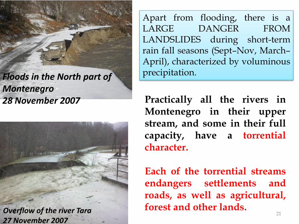
Floods in the North part of Montenegro28 November 2007
Overflow of the river Tara 27 November 2007
Practically all the rivers inMontenegro in their upperstream, and some in their fullcapacity, have a torrentialcharacter.
Each of the torrential streamsendangers settlements androads, as well as agricultural,forest and other lands.
21
Apart from flooding, there is aLARGE DANGER FROMLANDSLIDES during short-termrain fall seasons (Sept–Nov, March–April), characterized by voluminousprecipitation.

• Snow depth cover and its duration are crucial for the road traffic.
• Due to the snow fall in February 2010 most main roads, and a part of the Adriatic touts, were cut off.
• Also, the air traffic was suspended from the Podgorica Airport (Golubovci)
Žabljak, 20.03. 2007
2010
22
Extreme snow fall is an important natural disaster
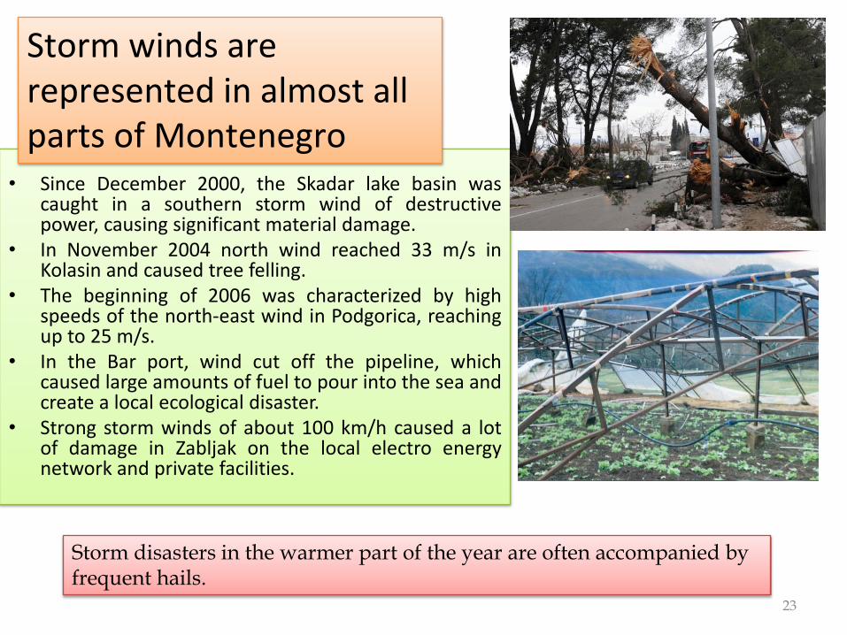
• Since December 2000, the Skadar lake basin wascaught in a southern storm wind of destructivepower, causing significant material damage.
• In November 2004 north wind reached 33 m/s inKolasin and caused tree felling.
• The beginning of 2006 was characterized by highspeeds of the north-east wind in Podgorica, reachingup to 25 m/s.
• In the Bar port, wind cut off the pipeline, whichcaused large amounts of fuel to pour into the sea andcreate a local ecological disaster.
• Strong storm winds of about 100 km/h caused a lotof damage in Zabljak on the local electro energynetwork and private facilities.
Storm winds are represented in almost all parts of Montenegro
23
Storm disasters in the warmer part of the year are often accompanied by frequent hails.

Drought
• Data and analyses done inHMI show that during thelast decades the emergenceof intensive droughts, in allthe forms, was frequent inMontenegro.
• Most consequences were feltin forestry, agriculture andwater procurement.
24
Droughts have a regional character and have more and more economic and ecological consequences.Significant droughts were recorded in the region in 1993, 1994, 1998, 2003, 2007 and 2010.
Of all the areas with climate characteristics of drought, the ones with most drought are Zetsko-Bjelopavlicka plain and the coast.
In the warmer part of the year,droughts of stronger intensityaffected the southern part ofMontenegro, and in the colderpart, the mountain region.
25
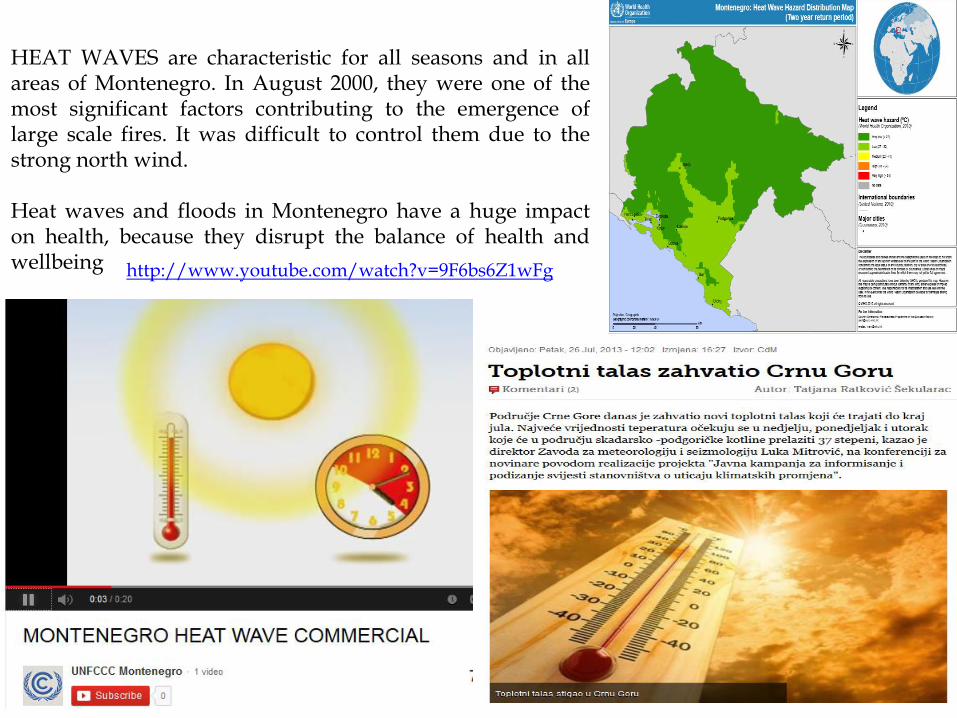
HEAT WAVES are characteristic for all seasons and in allareas of Montenegro. In August 2000, they were one of themost significant factors contributing to the emergence oflarge scale fires. It was difficult to control them due to thestrong north wind.
Heat waves and floods in Montenegro have a huge impacton health, because they disrupt the balance of health andwellbeing http://www.youtube.com/watch?v=9F6bs6Z1wFg

Fire near Tara River Canyon
(Source: “Pobjeda”, July 2007)
Fires in Banjani and Orijen area ( Source: “Pobjeda”, July 2007
New absolute maximum 44.8 C at the state levelmeasured 24 August 2007in Podgorica
The old maximum was 42.2 C in August 2003
Bare Kraljske, July 2007 26

Classification of forest based on NFPP
According to the National fire protection plan(NFPP), depending onthe amount and composition of fuel material, type of tree, soil andforest exposition, forests in Montenegro are classified in four groups:
• 1st degree – area of severe vulnerability– Bar, Budva, Ulcinj, Kotor, Herceg Novi, Cetinje and a part of Niksic,
Danilovgrad and Podgorica
• 2nd degree – area of high vulnerability– Pljevlja, Zabljak, Mojkovac, Andrijevica, Pluzine, Rozaje, Bijelo Polje,
Plav, Berane and Kolasin
• 3rd degree – area of moderate vulnerability– mountainous area (oak, hornbeams and other deciduous trees) and
area of plains (soft deciduous trees)
• 4th degree– area of small vulnerability:– north and north-eastern part of the mountainous area (beech forests)
27

Overview of the NUMBER OF FOREST FIRES in different regions
between 2004 and 2008 based on the HMI and MONSTAT data
28
According to the data, THE MOST VULNERABLE REGION IS THE SOUTHERN one, which has 44% of forest fires

Fires analysis in the period 2001 – 2009
according to the percentage of the fire area
.
In the Mediterranean countries, such as Montenegro, it is believed that the percentage of the fire area of:• 1 – 1.5% causes damage in
normal limits, • 1.6 – 3% leaves severe
consequences, while the values
• 3.1 – 5% have very severe and• above 5% disastrous
consequences. Based on this classification, the fires in 2007 had severe consequences.
29

Natural Hazards
Vulnerability
30
In compliance with the availableprojections, due to temperature increaseand change in precipitation, there will be adrastic increase of changeability of rivers,exemplified by floods and hydrologicaldroughts.
A large part of the coast will be flooded,and the flooding capacity will significantlyincrease in places which had never beenaffected by flooding waves.
Large parts of beaches will become smaller, and some willeven disappear. Forecasts say that the Bojana River willnot be able to flow naturally to the sea as it has so far, sothat Bojana delta will disappear.
About 40% of Montenegro is in the zone of significantseismic intensity higher than 8 degrees of the Richterscale. This affects about 60% of the Montenegrinpopulation.
EMEs will mostly affect the poor population which is mostlydependent on agriculture (especially in the north).

31

Climate hazards and illegal buildings seriously influenceMontenegro’s vulnerability.
32
In combination with a greater frequency and intensity of the socalled water-related hazards it creates a larger risk of a bigeconomic influence and health impact.

Conclusions
33
According to the estimates, specialattention should be paid to newsettlements on the coast, because theywill be affected by extreme weatherevents in the upcoming period.The fact that most illegal buildings area high seismic risk and a part of themis vulnerable to floods is a particularproblem.
It is evident that Montenegrinterritory is exposed to extremeclimate and hydrological events andprocesses.
There is a need to develop andimplement impact assessmentstudies (environmental, spatialand natural resources). It isneeded to conduct seriousanalysis and develop CLIMATECHANGE ADAPTATIONSTRATEGY.

Sanja Pavicevic, MSc PhysicsHead of Group of Satellite and Radar Meteorology,
Department for Meteorological Monitoring
Institute of Hydrometeorology and Seismology of MontenegroIV Proleterske 19
Podgorica, MontenegroPhone/fax: + 382 (0)20 655 431/197
Mob.: + 382 (0)67 209 949
E-mail: [email protected]@gmail.comSkype: sakapavicevicwww.meteo.co.me
34