Prescot town centre conservation area
36
Prescot town centre conservation area Character appraisal May 2012
Transcript of Prescot town centre conservation area

Prescot town centreconservation area
Character appraisalMay 2012

This document has been written in partnershipwith Knowsley Metropolitan Borough Council by:
The Conservation StudioBrackendene HouseCarron LaneMidhurstWest Sussex GU29 9LDTel: 01730 816710Email: [email protected]: www.theconservationstudio.co.uk

1 Introduction 51.1 The Prescot Conservation Area 51.2 The planning policy context 5
2 Location and landscape setting 72.1 Location and activities 72.2 Topography and geology 82.3 Relationship of the Prescot Town centre Conservation Area 8
to its surroundings
3 Historic development and archaeology 93.1 Introduction 93.2 Historic development 93.3 Archaeology 12
4 Spatial analysis 144.1 Layout and street pattern 144.2 Open spaces, trees and landscape 144.3 Focal points, focal buildings and views 154.4 Boundaries 164.5 Public realm 16
5 The buildings of the conservation area 185.1 Building types 185.2 Listed buildings 185.3 Locally listed buildings 205.4 Positive buildings 205.5 Building styles, materials and colours 21
Contents
3

6 Character areas 236.1 Town Centre: High Street, Eccleston Street and Market Place 236.2 Derby Street and West Street 246.3 Vicarage Place and Church Street 246.4 Sewell Street 25
7 Issues 267.1 Conservation area boundary review 267.2 Traffic and pedestrian movement 277.3 Vacant or derelict sites 277.4 Buildings at risk 277.5 Public realm 287.6 Advertising, shopfronts, signage 287.7 Article 4 Directions 287.8 Heritage assets 297.9 Care of the churchyard and adjoining woodland 29
Appendix 1 30Historic Map 1893
Appendix 2 31Historic Map 1907
Appendix 3 32Historic Map 1936
Appendix 4 33Prescot Townscape Appraisal Map
Appendix 5 34Prescot Character Areas Map
Appendix 6 35Prescot Conservation Area Boundary Review
4

1.1 The Prescot Conservation Area
Prescot is located in Merseyside, formerly partof south west Lancashire, and is one of theoldest former market towns in the area. The town sits on a south-facing hilloverlooking two streams and is dominated bySt Mary’s Church, listed grade I and the mostimportant historic building in the ConservationArea. In the eastern half of the ConservationArea, the remains of the medieval streetlayout, as defined by Eccleston Street andHigh Street and the narrow alleyways whichrun between them, are of special interest. To the west, a broad swath of woodland formsthe backdrop to the church, with a group ofmainly listed Victorian and Georgian buildingsclose by. Derby Street, which leads out of thispart of the town, contains further important19th Century buildings including a complex oflisted buildings close to the junction withKnowsley Park Lane. Apart from twochurches, and one purpose-built 19th Centurycommercial office, most of the other listedbuildings (of which there are 21) are eitherlate 18th or early 19th Century cottages orhigher status town houses. A few retainearlier fabric, although further evaluationwould be helpful. There are also a highnumber of historic buildings which are
considered to make a ‘positive’ contributionto the special interest of the ConservationArea, with good groups in Atherton Road,Eccleston Street, Market Place and Derby Street. A number of higher status late 19th Century houses, with more spaciousgardens, can be found in West Street, closeto St Mary’s Church.
Whilst coal mining and pottery were onceimportant in Prescot, of greater significance isthe history of clock, watch and tool-making,which once made this part of Lancashireworld-famous. Prescot was the centre of thisindustry in the late 18th and for much of the19th Century until competition fromSwitzerland and America in the 1870s led to the gradual erosion of its prominence.Until then, Prescot was a town of smallworkshops, attached to the back of almostevery house and producing a variety of veryhigh quality work. Today, only threeworkshops remain in the Conservation Area, a free-standing workshop (possibly 17th Century) at the back of No. 9 Market Place, and two integral workshops atNo. 17 Atherton Street and No. 74 Eccleston Street. The first two are protectedby statutory listing. However, just outside theConservation Area boundary is a detached
1. Introduction
5

former workshop (No. 20 Grosvenor Road)and a large cast iron factory, built rather late in1893 as the premises for the LancashireWatch Company. Both are listed grade II.
Prescot has suffered from a certain amount ofdemolition in the 1960s and 1970s, which wasusually associated with slum clearance orroad widening schemes. The construction ofthe Prescot Shopping Centre in the 1980s hasbeen largely over-taken by the provision ofthe much larger Cables Retail Park beyond,which has had a negative impact on theviability of the shops in the centre of theConservation Area. The creation of new towncentre car parks, with carefully designedstreet surfaces and landscaping, has helpedto a degree, but many of the shops remainvacant or in low value uses. There are anumber of prominent gap sites and evenmore examples of neglected buildingsurgently in need of repair. Advertisinghoardings, found on several prominentlocations within the Conservation Area, areparticularly inappropriate. All of these issuesneed to be considered as part of the PrescotTown Centre Conservation Area ManagementPlan, which will include the Council’sregeneration strategy for the area.
1.2 The planning policy context
Conservation areas are designated under theprovisions of Section 69 of the Planning(Listed Buildings and Conservation Areas) Act1990. A conservation area is defined as: “an area of special architectural or historicinterest the character or appearance of whichit is desirable to preserve or enhance”.
Section 71 of the same Act requires localplanning authorities to formulate and publishproposals for the preservation andenhancement of these conservation areas.Section 72 also specifies that, in making adecision on an application for developmentwithin a conservation area, special attentionmust be paid to the desirability of preservingor enhancing the character or appearance ofthat area.
In response to these statutory requirements,this document defines and records thespecial architectural and historic interest ofthe Prescot Town Centre Conservation Areaand identifies opportunities for enhancement.It is in conformity with English Heritageguidance as set out in Understanding Place:Conservation Area Designation, Appraisal and Management (March 2011). Additional government guidance regardingthe management of historic buildings andconservation areas is set out within theNational Planning Policy Framework (March 2012) and supersedes Planning PolicyStatement 5: Planning and the HistoricEnvironment (PPS5).
6

2.1 Location and activities
Prescot forms part of the MetropolitanBorough of Knowsley in Merseyside, nowseparated from the county of Lancashire. The town is located some nine miles to theeast of Liverpool city centre and lies on theA58 which connects Liverpool (eventually) to the town of Wetherby in West Yorkshire.The M57, M62 and M6 motorways are allclose by. The northern boundary of the townis contained by Knowsley Park, the historicseat of the Earls of Derby.
Activities within the Conservation Area arevery mixed. There are mainly commercialpremises (shops, offices and public houses)in the core area of Eccleston Street andLeyland Street, with mixed commercial andresidential uses in the High Street. ThePrescot Centre, a 1980s development whichcontains a supermarket, a small shoppingmall and a block of Council offices, lies to theimmediate south of Eccleston Street and linksthrough to it in two places. The status of thisshopping centre has been undermined by theCables Retail Park, which although close tothe town centre, has no direct pedestrian linksthrough to it and because of the change inlevel, feels relatively remote from it.
There is a further Council office in High Street,and this adjoins the Public Library, a 1960sbuilding of little merit but well used. Prescot Museum is housed in a prestigiousred brick Georgian house on the oppositecorner of the street. A Police Station islocated in a well detailed late 19th Centurybuilding in Derby Street. There are a fewsmall cafes in the Conservation Area and twolarger public houses, the Deane’s HouseHotel, in Church Street, and the Hope andAnchor Public House in High Street. Clock Face Public House in Derby Street,formerly West End house, is now a privateresidence. To the north of High Street are anumber of small businesses (car repairs etc.)housed in modern factory buildings of no merit.
There are four churches: St Mary’s (Church Street), Our Lady Immaculate and St Joseph (Vicarage Place), the OasisCommunity Church (Kemble Street) and theMethodist Church (Atherton Street), aprominent building which is currently emptyand in urgent need of repairs. Most of theother buildings in the Conservation Area arein residential uses, with two blocks of 1960sflats in Market Place/Sewell Street, and afurther block of flats (Yates’ Court) further
2. Location and landscape setting
7

south almost opposite the site wall of Tesco’sSupermarket. A three storey office block hasreplaced the public house shown on theoriginal Conservation Area map, which datedto at least 1893. Since the closure of theBICC factory in the late 1980s, there has been no single large employer in Prescot.The population was 11,184 in 2001.
2.2 Topography and geology
The Conservation Area sits on a south-facinghill overlooking the valleys of two smallstreams - the Prescot Brook to the west andthe Hindle Brook to the south - although these are mainly culverted. The land alsodrops westwards down Derby Street andWest Street, and there are therefore notableviews down Derby Street from the junctionwith Church Street. This topography meansthat St Mary’s Church sits on a natural summit and the early use of the site for a possiblepre-Conquest church becomes more likely.
The town lies on an outcrop of UpperCarboniferous red sandstone which containscoal measures, referred to as Westphalianrock. Prescot forms part of the LancashireCoalfield which stretches from Skelmersdalein the west to beyond Oldham in the east.The sandstone is tough and erosion-resistant,which makes it ideal for building walls, or foruse as a paving or roofing material. St Mary’sChurch is the best example of the use of thismaterial in the Conservation Area. In places,the carboniferous rocks also containclayrocks or ‘shales’ from which bricks can be made.
2.3 Relationship of the Prescot Town Centre Conservation Area to its surroundings
Prescot was originally the centre of a verylarge rural parish which stretched fromRainford in the north to the Mersey in thesouth. The map of 1909 shows a distinct,small town, surrounded by fields to the west,
south and east, with the historic parkland ofKnowsley Hall to the north. However, in morerecent times it has all but merged alongWarrington Road (the A57) with Whiston andRainhill, which lie to the south east of Prescot.
Although Knowlsey Park lies close to Prescot,the town feels somewhat remote from it dueto the construction of the A58 Prescot bypass,which runs in a roughly east-west directionaround the northern edge of the built-up area.The park contains the historic Knowsley Hall,areas of woodland, a large ornamental lakeand a safari park, but none of this is visiblefrom Prescot. A very large reservoir,constructed initially in the late 19th Century toserve Liverpool, and subsequently extended,lies within the eastern edge of the park atEccleston Lane End, but again, is not visiblefrom the centre. Beyond the reservoir arefurther fields which stretch up northwardstowards the A580.
To the west, the M57 curves around Prescot ina north-south orientation, with a large golfcourse (Huyton and Prescot) next to it.Further east, almost directly south of theConservation Area, can be found an area ofopen land. This was presumably once incoal-mining use and lies between the Steley Way and the railway line, with somelarge factories still evident. Prescot Stationstill serves the town, although it is a 10 minutewalk from the town centre southwards downthe hill to reach it. To the immediate north,west and south west of the Conservation Areaare residential suburbs, largely dating to theInter-war period.
8
3.1 Introduction
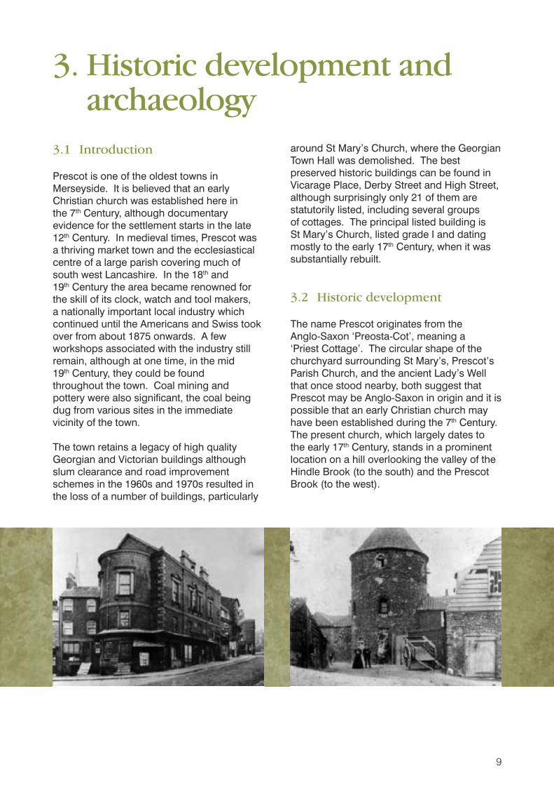
Prescot is one of the oldest towns inMerseyside. It is believed that an earlyChristian church was established here in the 7th Century, although documentaryevidence for the settlement starts in the late12th Century. In medieval times, Prescot wasa thriving market town and the ecclesiasticalcentre of a large parish covering much ofsouth west Lancashire. In the 18th and 19th Century the area became renowned forthe skill of its clock, watch and tool makers, a nationally important local industry whichcontinued until the Americans and Swiss tookover from about 1875 onwards. A fewworkshops associated with the industry stillremain, although at one time, in the mid 19th Century, they could be found throughout the town. Coal mining and pottery were also significant, the coal beingdug from various sites in the immediatevicinity of the town.
The town retains a legacy of high qualityGeorgian and Victorian buildings althoughslum clearance and road improvementschemes in the 1960s and 1970s resulted inthe loss of a number of buildings, particularly
around St Mary’s Church, where the GeorgianTown Hall was demolished. The bestpreserved historic buildings can be found inVicarage Place, Derby Street and High Street,although surprisingly only 21 of them arestatutorily listed, including several groups of cottages. The principal listed building is St Mary’s Church, listed grade I and datingmostly to the early 17th Century, when it wassubstantially rebuilt.
3.2 Historic development
The name Prescot originates from the Anglo-Saxon ‘Preosta-Cot’, meaning a ‘Priest Cottage’. The circular shape of thechurchyard surrounding St Mary’s, Prescot’sParish Church, and the ancient Lady’s Wellthat once stood nearby, both suggest thatPrescot may be Anglo-Saxon in origin and it ispossible that an early Christian church mayhave been established during the 7th Century.The present church, which largely dates tothe early 17th Century, stands in a prominentlocation on a hill overlooking the valley of theHindle Brook (to the south) and the PrescotBrook (to the west).
3. Historic development and archaeology
9

Prescot is first recorded in 1140, when adocument details the appointment of a rector,although it should be noted that theDomesday records for Lancashire are verypoor so its omission from that document maynot be significant. In the 12th and 13th
Centuries it appears that Prescot was dividedinto two small settlements, Prescot in the west and Churchley in the east. By the 14th Century the town was simply calledPrescot. For most of the 13th Century, theDacre family owned Prescot Manor, and in1333, William Dacre, 2nd Baron Dacre,obtained a charter for the holding of a threeday market and moveable fair at Prescot,confirming the existence of a settlement. The manor was based at Prescot Hall, whichwas located to the south of the Hindle Brookoff what was later Hall Lane. The town’simportance is reflected in its inclusion on theBodleian Map of Britain by Gough in 1350.
In 1391 Prescot Manor was sold to John ofGaunt, Duke of Lancaster. On his death, theManor was inherited by his son whosubsequently became King Henry IV. In 1447,King Henry established the University Collegeof St Mary and St Nicholas in Cambridge,which later became known as King’s College.Among the gifts he gave to fund the newUniversity College was the Manor and Rectoryof Prescot. Later, the arms of King’s Collegewere adopted as the Coat of Arms for Prescotand an example can be seen above theentrance of No. 8 Vicarage Place.
As the Lord of the Manor was so far away inCambridge, the running of the town was left toan appointed steward, who was member ofthe Stanley family, successively Earls of Derby.The Stanleys were based at Knowsley Hall,which lay to the north of Prescot. The Stanleyshad owned Knowsley Hall since 1385 whenthey acquired it by marriage. Knowsley grew from a hunting lodge to a large brick 18th Century house under the direction of the10th Earl of Derby, and was extended evenfurther in the Gothic style by John Foster Jun,then extended and altered again bysubsequent members of the same family. The Hall is still owned by the Stanley family.
As the Earl was often absent, Prescot wasassigned an early form of town government,known as the Court Leet or Manor Court. This was effectively removed by the Localgovernment Act of 1894, which firstestablished the Urban District Council,although it continued as a formality until 1936.
In 1562 the Layton family took over thetenancy of Prescot Hall and rebuilt it as alarge ‘mansion house’. In 1594 it is recordedthat Philip Hayton cut down some of his treesto make a ‘railway’ to bring coal out of hiscolliery, an interesting early reference to theuse of a railway for an industrialised process.At about this time, in 1592, a map of the areawas drawn and confirms that houses wereconcentrated to the immediate south and eastof the church, facing the Market Place, andalong Eccleston Street (then called NewgateStreet), with a scattering of houses facingwhat is now High Street. During the 1600s,the lease of Prescot Hall passed throughseveral hands until it came to Robert Roper atthe end of the century. In 1702 he soughtpermission from King’s College to rebuild theHall again, and a map of 1743 shows a twingabled brick house set back from Hall Lane.This building was demolished to make wayfor the expansion of the BICC factory at somestage after the 1930s.
Coal mining in Prescot is first recorded in theearly 16th Century, and was used initially toassist the salt-making industry in Cheshire,and then later, to provide power for the localpottery, glass and sugar factories. The coalseams were quite near the surface, making iteasier to mine, and new shafts were dugevery year as the old ones flooded and couldnot be drained. In 1712 the NewcomenPumping machine was invented, but as it costaround £1,000, a huge amount in those days,the price of coal was pushed up. A newturnpike road in 1726 encouraged furtherindustrial growth. During the first half of the18th Century the local colliery owners had amonopoly on the sale of coal to Liverpool, butthis was lost with the building of the SawkeyCanal in 1757, which meant that coal from St Helens could be brought into Liverpool at
10

comparable rates. Prescot Manor mineclosed in the mid 1800s, Whiston Colliery in1897 and Halstead in 1900, although this was re-opened between 1914 and 1984, initially to supply coal to the Cunard shipping line.Old coal shafts were still marked on maps to the south of the junction of Sewell Streetand the old College Road well into the 20th Century.
However, by far the most important industry inPrescot developed during the early 18th andcontinued well into the 19th Century after theestablishment of a watch making industry bya group of religious dissenters led by thePuritan Thomas Aspinwall in Toxteth inLiverpool in the early 1600s. From about1625 this group formed close ties withwatchmakers in London and simultaneouslythere developed a wide range of specialistmanufacturing industries which suppliedwatch making, clock making and precisiontools. These tools enjoyed an internationalreputation for quality, and by 1675 there werearound 50 watch makers in south westLancashire. At about this time (1666) therewere 32 households in Prescot with threehearths or more, confirming the size andstatus of the town. During the 1700s, asLiverpool expanded, the horologicalindustries became concentrated in Prescotand the surrounding villages. In 1773Thomas Pennant noted that Prescot:
“….abounds in the manufacturers ofcertain branches of hardware, particularlythe best and almost all of the watchmovements used in England, and thebest files in Europe”.
By 1800 Prescot had become the principalUnited Kingdom centre for the production ofwatch movements, watch and clockcomponents, and horological and precisiontools. By 1841 6% of the population wasengaged in watch making and by 1861 thishad risen to 10%. In 1862 the journalist J Johnson Brown described Prescot as “a town of little workshops”. After about 1875the expansion of the industry in the USA andSwitzerland provided greater competition, so
that by the 1920s only a few of the severalhundred workshops in the area were still inuse and by 1955 there were none.
Pottery was made in Prescot from at least1550 and at its height in the 1750s there werearound five potteries working in the town. The kilns would have dominated thelandscape and were centred around theEccleston Street area. A wide range ofpottery was produced, from large coursestorage jars, cooking pots and pans, to thinwalled drinking vessels. The early Prescotpotteries produced mainly earthenware from a mixture of local red and white clay. By theend of the early 19th Century, saltglazedstoneware was also in production. Each yeara fair was held in Prescot which becameknown as the ‘Mugg Fair’ because of thepottery on sale there. The construction of theSawkey Canel in the mid 18th Century enabled pottery to be taken by barge toLiverpool although the export of Prescotpottery to America is recorded as early as1702. The first Ordnance Survey map ofPrescot, dated 1848, shows in detail the three remaining potteries in Prescot at thattime. Brook Pottery was situated to the south west of the town near what is nowBeesley Road (Brook Cottage, grade II), with Mill Pottery to the east and Moss Potteryto the west. A small pottery, opened in the1840s in Kemble Street, was the last suchpremises to close in 1893.
Historic maps 1891,1907 and 1936 areincluded as Appendix 1, 2 & 3.
When the last potteries were closing inPrescot, another important local industry wasbeing created which provided employment tothe displaced workers. In 1891 J B Athertonand his brother Jacob opened a factory inPrescot on the large open site to theimmediate south of the town, taking over thesmall Electrical Engineering Works which wasfirst shown on the 1873 map. In the past, thisland had been used for open-cast mining andwas covered in holes. The company, calledthe British Insulated Wire Company, mademany advances in electrical technology.
11

They supplied power to Knowsley Hall, whichwas one of the first houses in the country tohave electric lights. Cables made in thePrescot factory were soon being exported allover the world, and for the first fifty years ofthe 20th Century, the company was the largestemployer in Prescot, eventually amalgamatingwith the British Insulated Wire Company toform BICC, a vast factory complex which musthave dominated Prescot for many years untilit was closed in the late 1980s, after whichwork continued on a smaller site nearby.
Prescot also claims an unusual connectionwith William Shakespeare due to his patron,Ferdinand Stanley, Lord Strange and thefuture 5th Earl of Derby. He was, unusually, a playwright and an author, and although hedied mysteriously at the age of only 35, hehad enough time to sponsor a group of actorscalled Strange’s Men who stagedShakespeare’s first drama, Henry VI, in 1592at the Rose Theatre in London to greatsuccess. Later that year, the theatres wereclosed due to the plague so the companymoved north to their patron’s ancestral seat at Knowsley Hall, and soon afterwards a playhouse was built in Prescot by Richard Harrington, an associate of theStanley’s. It is said that Shakespeare stayedin Knowsley Hall and that he composed anumber of his more famous manuscriptsthere, although there is no documentaryevidence for this. ‘Shakespeare North’ is arecent initiative which is supported by severalvery well known actors to rebuild thePlayhouse in the Prescot area as part of aregeneration strategy for the area, but it hasstalled due to the current economic situation.John Philip Kemble, the famous Victorianactor, was born in Prescot and his name isrecorded in the naming of Kemble Streetwhich stretches around the southern limits ofthe town centre.
In the middle of the 20th Century, Prescotsuffered from the usual effects of post-warclearances and redevelopment. The creationof large areas of surface car parking and theconstruction of the Prescot Shopping Centrehave eroded parts of the medieval streetlayout and the cohesiveness of the historic
townscape which remained relativelyunaltered until this time. To prevent furtherlosses, two separate conservation areas werefirst designated (Prescot Church and Prescot High Street), these beingamalgamated in 1978 to form the PrescotTown Centre Conservation Area. SewellStreet and the churchyard area were added in 1997. A large supermarket (Tesco’s) and a number of other large stores were built inthe 1990s to the south of the ConservationArea on the former site of the BICC factory.The name of the modern development is,fittingly, the Cables Retail Park.
3.3 Archaeology
The HER (Historic Environment Record) forMerseyside archives all the archaeologicalinformation for the five boroughs ofMerseyside storing data of Liverpool Wirral,Sefton, St Helens and Knowsley. The data is stored in a variety of formats includingpaper and electronically stored information.These incorporate historical and tithe maps,specific site information of settlement anddevelopment and other archaeology such asscatter finds including pottery and coinage.
Several archaeological studies have beenundertaken in Prescot with their findingsbeing published in various documents someare listed in the bibliography to the rear of this appraisal.
The publication of the document: PrescotAction Area an Archaeological View, by P Davey. Merseyside Archaeological Society,The University of Liverpool details the importance of Prescot and why it should beconsidered the most important historic andarchaeological site of its kind in the region.Due to it being:
…one of the oldest settlements…probably the best documented… retainsmuch of its medieval form and structure,is one of only two medieval settlements ofany consequence in Merseyside.
(Davey 1978)
12

The study identifies many of the town wallsand sites of specific archaeological interest.The map of the 16C sites in Prescot showsthe form and layout of the town which canrelate to the contemporary and present daymaps of Prescot. The Survey of UrbanSettlement by R A Philpott (1988) identifiescertain sites within Prescot where anarchaeological interpretation has been madeon the findings these include:
• 19 Market Place occupied by a building inthe 18C cellars had destroyed deposits onthe frontage. To the rear deposits of latemedieval garden soil containing quantitiesof pottery.
• 11 High Street, an investigative trenchacross the boundary of burgage plotsrevealed some medieval garden soil… thelater levelling of the site had used muchpottery manufacturing waste.
• 7-9 Derby Street on the site of land calledKiln Croft in 1592. The frontage had beendestroyed land by 18C cellaring but to therear late medieval or early post medievalsoil contained daub and pottery.
Two principal areas of archaeologicalimportance can be defined:
The medieval focus of the town, centredon the Market Place with burgages liningthe major streets, Eccleston Street,Kemble Street and High Street, is ofconsiderable importance in attempts tounderstand the development and natureof urban life in the region and shouldhave a high priority in the choices of sitesof excavation or rescue recording inadvance of building development.
The Ecclesiastical complex of the Priests Cot Vicarage and Church appearsto have remained relatively undisturbedand is of primary importance inelucidating the original of the settlementof Prescot, with wider implications for theunderstanding of pre conquest settlementpattern and the development of the parishsystem in south Lancashire.
(Extract from Philpott 1988)
Prior to any development where there ispotential for archaeology the HistoricEnvironment Record should be consulted.The Historic Environment Record(archaeology) currently resides in NationalMuseums Liverpool. Discussions arecurrently underway with the five BoroughsLiverpool, Wirral, Sefton, St Helens, andKnowsley together with English Heritage andNational Museums Liverpool on how toupdate the Historic Environment Record using a variety of medium.
13

4.1 Layout and street pattern
Prescot retains a basically medieval layout (St Mary’s Church and churchyard, MarketPlace and Eccleston Street) with burgageplots being described in the town centre in1537. These presumably stretched back fromeither side of Eccleston Street, and some ideaof the plots can still be seen on the 1893 map,with rows of terraced cottages and long, thinalleys all stretching back towards High Streeton the north side of Eccleston Street. Similar linear plots also appear on the northside of High Street, which could be medievalin origin.
The medieval layout of Prescot was changed by road improvements of the 18th and 19th Centuries including the creationof new turnpike roads in the 1720s and theconstruction of Atherton Street and Aspinall Street in the 1870s. These provideda way through the town without the need topass through the congested centre aroundMarket Place and Church Street.
Today, the principal feature of theConservation Area is therefore the circular,possibly Anglo-Saxon churchyard to St Mary’s Church which formed the western
edge of the historic Market Place, nowsomewhat denuded since the removal of historic buildings in the 1960s.Immediately opposite the church, Eccleston Street, formerly called Fazackerley Street, leads eastwards out ofPrescot and this street remains thecommercial core of the town. The High Streetruns roughly parallel to Eccleston Streetalthough the dense network of small streetsand courts which are shown on the early 20th Century maps have been incrementallycleared and are now the site of the towncentre car parks. Similarly, Church Street,which bends noticeably between High Streetand Market Place, has also been subject to a certain amount of change due to thedemolition of some of the buildings whichfaced it and the creation of Prescot Bus Station.
4.2 Open spaces, trees and landscape
The Conservation Area contains a largeamount of open green space to the west andsouth of St Mary’s Church, part of which is thehistoric graveyard and therefore open to thepublic. Still within the Conservation Area, alarge area of dense woodland lies further west
14
4. Spatial analysis
in which the modern Vicarage is located, butthis land is private. Both of these spaces arenotable for their mature trees and sense oftranquillity. Further trees can be found closeby in West Street, where they form theboundaries to some of the large late 19th orearly 20th Century houses which can be foundin this part of Prescot. Some more recent treeplanting is evident in Derby Street, where atree group has been planted in one area onthe south side of the road, probably inconjunction with the adjoining housing, which appears to date to the 1960s or 1970s.Trees in front of the 1960s Public Library inHigh Street help to shield the modern buildingfrom view.
Further east in the built-up part of theConservation Area, there are no strong spatial‘focal points’. The Market Place is now arelatively quiet backwater as the vehicular way through the town has been sealed off.This space, once overlooked by the GeorgianTown Hall, has lost any sense of its formerfunction and whilst it does provide pleasantviews towards St Mary’s Church, these areblighted by the poorly maintained open spaceto the south east of the church which is inurgent need of improvement.
At the eastern end of Eccleston Street, aformer graveyard can be found on the south side backing onto Ackers Street. This contains some trees and a fewgravestones, and again, is in need ofimprovement. To the north, beyond EatonStreet, is a municipal park with a children’splay area (King George V Memorial Garden),but this is just outside the Conservation Area boundary.
There are some mature street trees in Leyland Street, clearly planted for visualeffect, but otherwise the trees in the easternpart of the Conservation Area are somewhatscarce and much could be achieved byadditional tree planting, particularly inEccleston Street.
4.3 Focal points, focal buildings and views
Focal points The most obvious focal point in theConservation Area lies between St Mary’sChurch and Eccleston Street around theformer Market Place, although the originalfunction has long since ceased and the areais degraded by the low quality public realmand the empty site below the church. To thenorth, more careful landscaping to the areaaround the church and Church Street hasenhanced its status, although the changes to the road layout and the loss of frontagebuildings are both regrettable features. There are further focal points at roadjunctions, namely at the junction of Derby Street, Knowsley Park Lane, Liverpool Road and West Street in the west, and the junction of Atherton Road,Eccleston Street, and Aspinal Street in the east.
Focal buildingsSt Mary’s Church, with its raised site, tall spireand imposing architecture, is the single mostdominant building in Prescot. Other focalbuildings include:
• Prescot Community Church, Kemble Street
• The Red Lion Hotel, Kemble Street/Market Place
• The Deane’s House Hotel, Church Street
• No. 72 Eccleston Street
• Prescot Methodist Church, Atherton Street
• Prescot Museum, No. 34 Church Street
• No. 3 High Street
• The Hope and Anchor Public House, High Street
• No. 2 Derby Street
• Print House, No. 16 High Street
• The Police Station, Derby Street
• Nos. 42a, 42b and 42c Derby Street
• West End House, Liverpool Road
15
ViewsBecause of the enclosed character of much ofthe eastern part of the Conservation Area, andthe lack of any particular ‘focal points’, viewsare largely limited to views across or alongindividual streets, but they are hardly notable.However, in the centre of the ConservationArea, there are a number of important viewslargely focusing on St Mary’s Church. These can be long or short views, as the spireof the church is a very dominant feature evenfrom some distance. There are also viewsalong Derby Street (both up and down thehill) and more enclosed views up West Streetfrom the junction with Derby Street. Shorterviews within St Mary’s graveyard are of note,with pleasant vistas along the pathways andviews into the site from the immediatesurrounding area.
4.4 Boundaries
Because many of the buildings are located onthe back of the pavement, boundaries do notfeature in the main streets to any great extentin the town centre, although in the moreresidential areas, such as West Street, andDerby Street, they are of greater prominenceas the buildings tend to be set back in gardenplots. Unsurprisingly, many of theseboundaries are provided by stone walls ofvarying designs, and in the Mill Street areathey are particularly tall and dominant.Locally referred to as the ‘Town Walls’, theymay have medieval origins. The wall aroundthe Old Mill House Public House is made froma brown coloured rubble stone laid veryroughly, but it is notable for its height (aboutthree metres) and length - it encompasses the back garden to the public house and thenturns south along the narrow alleyway thatleads south towards Eccleston Street. A further notable wall can also be seen alongthe north side of Derby Street, with half roundcopings set on roughly coursed sandstone.Outside Nos. 8 and 10 Derby Street, a longstone wall retains a canted stone copingwhich was clearly once used as the base forcast iron railings. In the same street, someproperty owners have reinstated the railings
using more modern details, usuallyunobtrusively. West Street also retains somehistoric sandstone walls, again built usinglarge, well coursed sandstone blocks - of noteis the sandstone wall around the RomanCatholic church. In West Street, there arealso a number of important front walls builtfrom brick (which matches the material of theadjoining historic houses) with moulded stonecopings. Sometimes, but principally in West Street, these are backed up by hedgingand trees. Some of the properties retain welldetailed gate piers, made of stone withpyramidal copings, such as the pair outsideWoodleigh in West Street.
4.5 Public realm
The ‘public realm’ covers the public spacesbetween the buildings and the details, suchas street lighting or signage, which contributeto these spaces. Most of the public realm inthe Conservation Area is the responsibility ofKnowsley Borough Council.
The centre of the Conservation Area, namely the area around St Mary’s Church,Church Street, and Market Place, has beenthe subject of a comprehensive enhancementscheme that has provided new natural stonepaving and stone setted roadways, most ofwhich appear to have been carried out in1979. Close to the church, the pavement ismade up from re-cycled grave stones. This area is now largely pedestrianised anddespite the use of metal gates to stop throughtraffic, illegal car parking is evident. Victorian-style black painted street bollards and welldesigned modern street lights with atraditional appearance are appropriate details.A sundial feature in modern paving is locatedclose to the church, where crisp redsandstone walls contain the pavementsimmediately outside the listed building, withgate pillars providing a sense of ‘arrival’.Further areas of setts, laid out in a circularpattern, appear rather fussy. A War Memorialis an important feature just to the south eastof the church. The natural stone flagscontinue down Market Place as far as the
16

junction with Kemble Street. In the MarketPlace, Eccleston Street, High Street andDerby Street, tall curved head street lights arequite dominant.
There are some small examples of originalhistoric paving, such as the stone settedcrossovers in the pavement outside KnowsleyCouncil Offices in High Street, and along thesouthern continuation of Stone Street towardsEccleston Street, although there is also somemodern paving using traditional stone setts.However, these materials must once havebeen commonplace and their loss diminishesthe character of the Conservation Area.Further natural stone paving, mixed withmodern materials and details, can be found inEccleston Street.
Street nameplates are usually dark green withwhite lettering and a white band - they appearto be aluminium. There are also otherdesigns, which are modern and functional.Many are dirty and require cleaning orcompletely replacing to a common design.Some historic street nameplates remain, andare fixed to buildings. These are made of castiron, with rounded corners, and have blackletters on a white background. An examplecan be seen at the southern end of AthertonStreet, fixed to the Margaret Rose shop, and afurther example, of slightly different design,can be seen on The Print House in HighStreet. There are a few sturdy cast ironpavement grilles, like the one outside Nos. 5 and 7, Atherton Street.
A Borough of Knowsley Public Notices boardcan be seen in Eccleston Street, somewhatneglected. The High Street suffers generallyfrom a plethora of traffic signs which add tothe poor visual appearance of the street whichhas already been adversely affected by thehigh number of modern advertising hoardings.
Otherwise, the Conservation Area contains noother special public realm details. The streetsare particularly badly paved, with a variety ofmodern materials, often in poor condition.
17

5.1 Building types
The buildings of the Prescot Town CentreConservation Area largely date to between themid 18th Century and the early 20th Century.There are some Art Deco buildings, mostnotably in Eccleston Street, of which theformer cinema (dated 1922) is the largest andmost prominent, although it appears to havebeen significantly altered as part of thePrescot Centre project.
The majority of the buildings are two or threestorey houses, built in a terraced formalthough the Conservation Area does alsoinclude a number of prestigious brick housesdating to the Georgian period. AthertonStreet contains a long row of late 18th Centuryhouses, of which only one (No. 17) is listed.Mixed in with the residential property are anumber of public houses and churches, andwhilst the town was once heavilyindustrialised, little remains (at least within theConservation Area) to remind the onlooker ofthis fact.
The largest building is the 17th Century grade Ilisted St Mary’s Church, with the RomanCatholic church (which is located close by)
being almost as large, although due to itslocation it is somewhat hidden from view. The Methodist Church in Atherton Street isprobably the third largest building in theConservation Area. Many of the buildings inEccleston Street and High Street were built asresidences but have since been convertedinto ground floor shops, so they provide bothstreets with a largely domestic sense of scale.
There are several very large mid to late 20th Century buildings in the ConservationArea, the most visible being the blocks of1960s flats in Sewell Street (Greenall Court).A large care home and further blocks of flatscan also be seen to the north of High Street,their scale and large footprint beingsomewhat out of character with the area.
5.2 Listed buildings
There are 21 listed buildings in theConservation Area, all listed grade II apartfrom St Mary’s Church, which is listed grade I.Apart from the two churches, they were allbuilt as private residences, although one (No.2 Derby Street) is an unusual example of apurpose-built early 19th Century office.
18
5. The buildings of the conservation area

Grade I
St Mary’s Church
St Mary’s Church retains a 14th Century vestry,but much of the building dates to a rebuild of1610 (dated on plaques) by John Ogle andSir John Bold. The tower and spire wereadded in 1729 at a cost of £455 and laterstrengthened, and the aisles were added in1818-19. The font is possibly Anglo-Saxon.
Grade II
No. 17 Atherton Street
This property forms part of a long terrace ofsimilar late Georgian houses dating to c1790.It is two windows wide, three storeys high,with a slate roof over sash windows and a late19th Century shopfront. The importance of thebuilding lies in the survival of an integralsecond floor watch-makers’ workshop whichis visible to the rear.
Prescot Museum, No. 34 Church Street
This substantial three storey red brick housewas built in 1776 with sash windows arrangedsymmetrically around a central ground floorfront door. A raised pediment and whitepainted stone parapet hide the roof.
Offices of Henry Cross and Son, No. 2 Derby Street
Unusually, this single storey building was builtin the early 19th Century as offices for a localsolicitor, and the building has remained in theownership of the same firm since then. It isfaced in painted stucco with three sashwindows to the front, the central window lyingin a curved bay.
Nos. 44, 46, 48 and 50 Derby Street
This is a short terrace of one window wide two storey cottages dating to the early 19th Century which were rebuilt in 1985. The cottages are faced in brick with concretedressings and a slate roof.
West End House (formerly the Clock FacePublic House) No. 54 Derby Street, and No. 52 Derby Street
Formerly a public house, No. 54 was built as adower house to the Knowsley estate and is asubstantial two storey building which dates tothe early 19th Century. It sits at right angles tothe main road, across what would once havebeen a large garden but is now a car park.The sandstone building is five windows wide,with a central entrance marked by an Ionicporch, and the elevations are faced in brickwith stone dressings and a shallow pitchedslated roof above. No. 52 is attached to No.54 but is a more modest building facing theroad. The stable building to the rear isseparately listed.
No. 30 Eccleston Street
No. 30 is the only obviously timber framedbuilding in the Conservation Area and retainsa highly decorative timber framed street frontwith a gable above a modern shopfront. It isdated 1621 although there is some disputeabout the authenticy of this. In 1921 (both aredated) an almost matching building wasadded to the east. The building fronts part ofthe Prescot Shopping Centre but is said toretain some original timber framing andwattle-and-daub panelling.
Masonic Hall, No. 3 High Street
No. 3 is a symmetrical early 19th Century twostorey brick house with stone dressings, withthree windows to the first floor and four to theground floor. The central front entrance ismarked by a later Doric porch. The shallowpitched roof is covered in slate with axial endstacks in brick.
No. 37 High Street
This building dates to c1815 and is a small,two window wide house with a central frontdoor with a complete fanlight. The elevationsare faced in brick with stone dressings, andthe windows are sashed.
19

No. 11 High Street including wall andgatepiers
No. 11 is a substantial white-painted threestorey brick house and was formerly theConservative Club. It dates to the late 18th Century and is five windows wide with a central front door marked by a pedimented doorcase with Doric half-columns. The rusticated stone retainingwalls, gatepiers and wall piers are also listed.
No. 9 Market Place
The building fronts the Market Place andforms part of a terrace of similar, probablyearly 19th Century houses, two windows wideand three storeys high. It has a modernshopfront. Its special interest lies in thesurvival to the rear of a possibly 17th Centurysingle storey free-standing tool and watch-maker’s workshop built from brick with astone-flagged floor.
No. 2 Vicarage Place
No 2 dates to the late 18th Century and is builtfrom brick with stone dressings. The fourpanelled front door is defined by panelledpilasters and a pediment, painted white.
No. 4 Vicarage Place
No. 4 is also late 18th Century and is a moresubstantial house, three storeys high and fivewindows wide, arranged symmetricallyaround a central front door. The windowshave six over six light sashes.
No. 6 Vicarage Place
No. 6 is a smaller, two bay wide, two storeyhouse which dates to the late 18th Century. It is faced in brick with stone dressings.
No. 10 Vicarage Place
No. 10 dates to c1740 and is a tall (threestorey) four window wide brick house with aslate roof. The windows are all sashed andthe front door is defined by panelled pilastersand a pediment. The stone coped gardenwall has ornate cast iron railings with squareiron gatepiers and a gate.
No. 14 Vicarage Place
This property dates to the late 18th Centuryand is a small brick house with stonedressings and a slate roof. It was built asservants’ quarters for No. 10, which it adjoins.
R C Church of Our Lady Immaculate and St Joseph, Vicarage Place
The church was built in 1856-7 to the designsof J Hansom. It is faced in rock-faced stonewith ashlar dressings and a steeply pitchedslate roof
5.3 Locally Listed buildings
There are currently no locally listed buildingsin Prescot.
5.4 Unlisted historic buildings
In addition to the listed buildings, a largenumber of unlisted historic buildings can befound in the Conservation Area, most of whichwere built for residential purposes, althoughmany, particularly in High Street andEccleston Street, have now been convertedinto shops or other commercial premises.They are marked in purple on the TownscapeAppraisal Map and are considered to make apositive contribution to the character orappearance of the Conservation Area.Unlisted buildings within the Prescot TownCentre Conservation Area which make aparticular contribution include severalchurches or chapels, as well as public housesor small hotels and one former mill (now theMill House Public House in Mill Street).Examples include:
Non-residential buildings
• Prescot Methodist Church, Atherton Street(built in 1908)
• Prescot Community Church, Kemble Street (formerly the PalaceCinema)
• Deane’s House Hotel, Church Street
20

• Hope and Anchor Public House, High Street (dated 1906)
• The Police Station, Derby Street
• The Social Services offices next to thePolice Station, Derby Street
• Nos. 2-16 even Leyland Street
• Nos. 19-23 Eccleston Street (the rear ofNo. 23 contains timber-framing which isvisible from Stone Street)
Residential buildings
• Late 18th Century terraced properties inAtherton Street
• Nos. 79-97 Derby Street
• Houses in West Street - a well detailedcollection of late 19th Century terraced andsemi-detached properties
Individual applications of Conservation AreaConsent (CAC) to demolish such buildingswill need to be assessed by the BoroughCouncil on a case-by-case basis, butgenerally, permission will be refused. All applications for CAC will need to beaccompanied by a reasoned justification forthe demolition of the building (as is alreadyrequired for the demolition of a listedbuilding), and the applicant must prove thatthe following:
• The building is incapable of beneficial use
• The building is beyond the point ofeconomic repair
• The building does not make a ‘positive’contribution to the character orappearance of the Conservation Area
• That the building has been marketed andan alternative use/owner has not found
5.5 Building styles, materials and colours
Most of the buildings in the Conservation Areadate to the late 18th or the 19th Century, andare built from brick or stone which has beenrendered and painted. They were largely builtas houses although many are now incommercial use, with a variety of shopfronts,most of little merit. The most obvious use ofsandstone for building stone can be seen atSt Mary’s Church and on West End House,and although sandstone quarries werehistorically not far away, the high cost of thesandstone, and the relative availability oflocally made brick, made this material more popular.
Apart from St Mary’s Church, previouslydescribed, the earliest building in theConservation Area appears to be No. 30 Eccleston Stree (dated 1621),although some timber framing remains inNos. 19-23 Eccleston Street which is visiblefrom Stone Street - this probably dates to the17th Century as well. Most of the buildings inthe Conservation Area were built in brick fromthe mid 18th Century onwards withconventional Georgian details (shallowpitched slate roofs, sashed windows,symmetrical elevations and pedimenteddoorcases with panelled front doors).Variations on this basic theme can be seenthroughout the Conservation Area, althoughthe only building which truly stands out isPrescot Museum, but only because of itsdominant location as it is very simply detailed.There are a number of very well detailed midto late 19th Century houses in West Streetwhich add greatly to the special interest of theConservation Area, but again, the details(more sash windows, brick elevations andslate roofs) are simple and robust.Occasionally, some Gothic influences creepin, like some of the gate piers and porches tothe houses (including Woodleigh) closer to St Mary’s Church.
21

Colours are muted and include red brick orrender, sometimes painted a pale pastelcolour, with white painted windows.Contrasting brickwork, in red and blue/black,can be seen on some of the late 19th Centuryhouses in West Street. Roofs are mainlycovered in grey slate.
There is any number of modern shopfrontsand a few which retain some elements ofearlier examples. The best, and mostcomplete historic shopfront, is Margaret Rose,No. 61 Eccleston Street (late 19th Century).Otherwise, the shopfronts tend to be poorlydesigned and many use garish colours andpoor quality signage.
22
Based on building density and type, streetlayout, the relationship of buildings to openspaces, and landscape details, the PrescotTown Centre Conservation Area provides fourareas of very distinctive character, as follows:
• Town Centre: High Street, Eccleston Streetand Market Place
• Derby Street and West Street
• Vicarage Place and Church Street
• Sewell Street
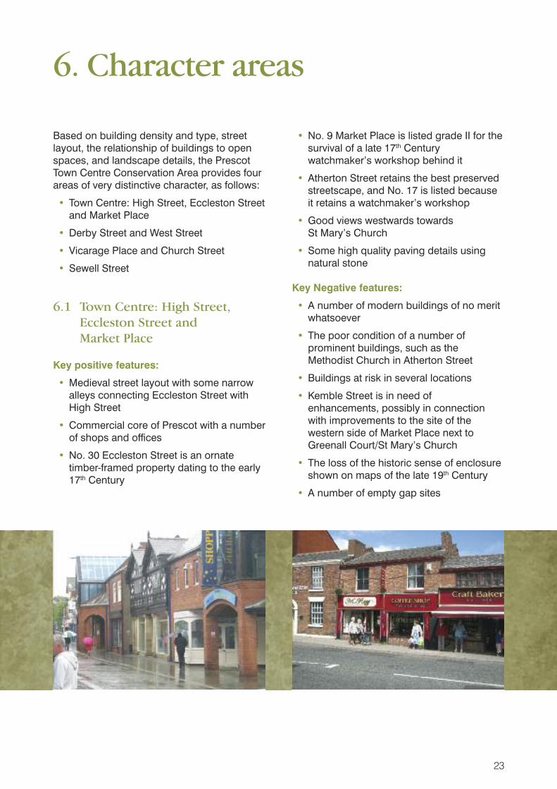
6.1 Town Centre: High Street, Eccleston Street and Market Place
Key positive features:
• Medieval street layout with some narrowalleys connecting Eccleston Street withHigh Street
• Commercial core of Prescot with a numberof shops and offices
• No. 30 Eccleston Street is an ornatetimber-framed property dating to the early17th Century
• No. 9 Market Place is listed grade II for thesurvival of a late 17th Centurywatchmaker’s workshop behind it
• Atherton Street retains the best preservedstreetscape, and No. 17 is listed becauseit retains a watchmaker’s workshop
• Good views westwards towards St Mary’s Church
• Some high quality paving details usingnatural stone
Key Negative features:
• A number of modern buildings of no meritwhatsoever
• The poor condition of a number ofprominent buildings, such as theMethodist Church in Atherton Street
• Buildings at risk in several locations
• Kemble Street is in need ofenhancements, possibly in connectionwith improvements to the site of thewestern side of Market Place next toGreenall Court/St Mary’s Church
• The loss of the historic sense of enclosureshown on maps of the late 19th Century
• A number of empty gap sites
6. Character areas
23

• Dominant advertising hoardings
• Many poor quality shop frontages
• Too much street signage
• Poor quality pavements in some areas
• Illegal on-street car parking despite theclose proximity of surface car parking
• Empty or vacant shops or properties,sometimes boarded or shuttered up
• A number of mainly modern buildingswhere redevelopment would be welcome
• Despite the pedestrianisation of Eccleston Street, cars still drive along it during the day
6.2 Derby Street and West Street
Key positive features:
• Attractive location on west-facing slope,with long views along Derby Street overthe roofs of a collection of mainly listedbuildings at the junction with KnowsleyPark Lane
• Derby Street’s principal buildings are No. 2 (Tickle Hall Cross Solicitors) at oneend of the street and West End House andthe adjoining house and stables at theother end - both are listed grade II
• The unlisted but ‘positive’ Police Station and adjoining building (No. 10Derby Street) are also of note
• Long terraces of well detailed mid to late19th Century houses in both West Street(Nos. 2-12 even)and Derby Street (Nos. 79-97 odd)
• West Street has the character of a quietresidential suburb with spacious plots andmainly semi-detached late 19th Centuryhouses, unusually well preserved
• Most of the historic buildings appear to bein reasonable condition
Key Negative features:
• Busy traffic along Derby Street, a principalroute into Prescot town centre
• A large group of terraced houses facingboth Derby Street and West Street,probably dating to the early 1970s
• A certain amount of ‘left-over’ space withsome tree planting and car parking areas
• The unlisted but positive residentialbuildings need to be protected fromunsympathetic alterations, such as theuPVC windows on many of the unlistedbut positive houses in Derby Street
6.3 Vicarage Place and Church Street
Key positive features:
• Highest concentration of listed buildings inthe Conservation Area - St Mary’s Church;Nos. 2, 4, 6, 10 and 14 Vicarage Place;and the RC Church of Our LadyImmaculate
• Enclosed, tranquil location next to a largearea of natural woodland and the welltreed graveyard
• The paving and roadway in both VicaragePlace and Church Street have alreadybeen enhanced with well detailed naturalmaterials
Key Negative features:
• The continuity of streetscape in Church Street has been adversely affectedby demolitions to create the Bus Station tothe north
• Some of the paving might be consideredrather over-designed and fussy in itsdetailing
• The use of barriers and ‘gateways’ inChurch Street, to prevent vehicles usingthe street, has created a rather artificialcharacter to the area
• Large advertising hoardings at the junctionwith Derby Street
• Illegal car parking in the Church Streetarea appears to be commonplace
24

• The Deane’s House Hotel is in need ofsome enhancements and advertising andsignage need to be resolved
• The close proximity of the poor qualitypublic realm in the area to the south eastof the church facing Market Place
• The close proximity of Greenall Court, alarge 1960s block of flats facing the topend of Sewell Street
• The care of the graveyard including thetrees and the gravestones and othermemorials
• The War Memorial should be listed
• ‘Blockbusters’ and the adjoining garagebuilding forms part of a prominent cornersite at the eastern end of West Streetwhere it meets Church Street - the wholesite would benefit from sympatheticredevelopment
• The Church Hall is a 1960s building of nomerit (though it does sit on a backlandsite)
6.4 Sewell Street
Key positive features:
• Two small groups of positive late 19th Century terraced cottages Nos. 30-38 and 56/58
• Good views from Garden Walk into theadjoining churchyard
Key negative features:
• Busy traffic along Sewell Street
• Close proximity of the modern commercialdevelopment including the large Tesco’sSupermarket
• Greenall Court and the adjoining block -both 1960s buildings of no merit
• Untidy car parking
• Post WWI buildings along ManchesterRoad and into Garden Walk, of no specialinterest
• The northern end of Garden Street hasincoherent streetscape with a variety ofbuildings and untidy plots
25

Based on the negative features identified inthe previous chapter, the following Issues areconsidered to be the principle matters whichthe emerging Prescot Town CentreConservation Area Management Plan needsto address:
7.1 Conservation area boundary review
The Conservation Area boundary has beenextended twice, once in 1978 (when twoseparate conservation areas around St Mary’s Church and the High Street wereamalgamated) and again in 1997, whenSewell Street was added. Since then, acertain amount of new development hastaken place which has weakened thecohesiveness of the historic streetscape, so anumber of minor deletions are proposed. Inaddition, it is proposed that the 20th Centurycemetery off Manchester Road is added tothe Conservation Area.
Deletions:
(i) Delete the small area of car parking tothe west of the garden wall enclosing
the present car parking area to West End House - this relates to amodern building of no special interest;
(ii) Delete the Inter-war houses facing theKing Edward VII Memorial Gardens onthe northern edge of the ConservationArea which are not of any specialarchitectural or historic interest;
(iii) Delete the southern end of Sewell Streetand Garden Lane, which contain onlymid to late 20th Century buildings whichare not of any special architectural orhistoric interest.
Additions:
(i) Add the 20th Century cemetery whichlies to the west and south of the existingConservation Area. The cemeterycontains some well detailed entrancegates and boundary railings which dateto 1923 (when the cemetery wasopened), and some notable maturetrees, as well as making a majorcontribution to the setting of thewoodland edge surrounding themodern vicarage, and the graveyard toSt Mary’s Church, both of which itimmediately abuts.
26
7. Issues

7.2 Traffic and pedestrian movement
The present traffic management schemeprevents traffic (apart from buses and taxes)from crossing the Conservation Area - whilstthis has made a safer environment forshoppers and other visitors to the towncentre, it does make the town centre feelsomewhat cut off. Eccleston Street has beenpedestrianised, but a certain amount of trafficstill uses it. Despite the provision of well laidout surface car parking in the town centre,illegal car parking is evident in the Eccleston Street and Church Street areas.Pedestrian links to Prescot Railway Stationand the Cables Shopping Centre are also poor.
Clearly a balance between pedestrianmovement, the demands of road users andthe need for accessible and cheap carparking all need to be attended to if the towncentre is to be revived as a viable commercialcentre. A comprehensive schemeencompassing the needs of the various towncentre users would be helpful and couldinclude public realm improvements asdetailed below.
7.3 Vacant or derelict sites
There are several sites where enhancements(including possibly total redevelopment)would be welcome. Some of these havebuildings of some historic interest whererefurbishment rather than demolition wouldbe welcome. Key sites include:
• The site to the south east of St Mary’sChurch next to Market Place - this isprobably the most important and visiblepotential redevelopment site in the wholeConservation Area
• The former PSD vehicle hire and WestStreet garage site at the eastern end ofWest Street
• The corner of Kemble Street with SewellStreet (nos. 48 and 50 Kemble Street are
historic buildings but have been muchaltered)
• Various buildings or blocks of buildings inEccleston Street and High Street, notably:
• The triangular block between HighStreet, Eccleston Street and ChapelStreet, which contains a somewhataltered partly ‘positive’ building (Nos. 4-16 Warrington Road) whichcould be enhanced, and a number ofmodern buildings of no merit, as wellas an empty open site with advertisinghoardings
• The ‘dead’ advertising hoardings sitebetween Nos. 18 and 24 High Street
• The empty corner site below St Mary’sChurch, facing Market Place
• The 1960s buildings on the south sideof Eccleston Street (Nos. 4-20 even),and although just outside theConservation Area, Nos. 58-70 evenEccleston Street
7.4 Buildings at risk
There is a high number of part or fully vacantshops or upper storeys in Eccleston Street,with a few more in High Street/WarringtonRoad. The most obviously ‘At Risk’ historicbuildings include:
• Prescot Methodist Church, Atherton Street- an important local building with a 1960sextension. The extension is of no meritand could be demolished and replacedwith something more appropriate
• Nos. 5-11 odd Eccleston Street - allcurrently empty
• West End House, Derby Street - a grade IIlisted former public house which iscurrently vacant
• Prescot Community Church, KembleStreet - apparently current empty
27

7.5 Public realm
A great deal has been achieved by theCouncil in the provision of high quality publicrealm improvements, most notably in theChurch Street area, as well as the westernend of Eccleston Street. The imposition of acommon palette of materials, signage andcolours for the whole Conservation Areawould greatly improve the streetscape.
Further improvements could include:
• Former graveyard, junction of Eccleston Street with Ackers Street - new trees, lighting and public seating
• Atherton Street - needs better qualitypaving and street lighting
• Eccleston Street - building on traditionalpaving already installed - needs newlighting and more street trees, as well asbetter quality litter bins, signage andpublic seating
• Leyland Street - an important link betweenHigh Street and Eccleston Street - wouldbenefit from better quality paving andstreet lighting
• Site on corner of Derby Road and Church Street - remove advertisinghoardings and relandscape
7.6 Advertising, shopfronts, signage
It has been noted how the poor quality of the shopfronts and shop signage in Eccleston Street in particular has adverselyaffected the streetscape. Problems includebadly designed modern shopfronts with over-dominant fascias; the use of modern materials(such as plastic) for these shopfronts; poorquality signage using garish colours; andneglected or boarded up vacant shops.Some of the shops are in modern buildingswhich are so poorly detailed that they couldbe considered as having a negative impact onthe streetscape.
Taken as a whole, the Council needs toaddress the above issues through aconcentrated scheme which could include:
• Grant aid to assist private owners replaceor upgrade their existing shopfronts
• The provision of free advice about newshopfront design
• The possible provision of an ‘exemplar’new shopfront to encourage privateowners to follow the Council’s example
• The provision of other initiatives toencourage shoppers into Prescot towncentre, to provide private property andbusiness owners with an incentive toinvest in the area
7.7 Article 4 Directions
The use of Article 4 Directions enables localplanning authorities to control minoralterations to unlisted residential propertywhich could otherwise be carried out by aproperty owner without planning permissionunder their ‘permitted development’ rights.Alterations such as the installation ofreplacement doors and windows, reroofing inmodern materials, the removal of chimneys,the addition of porches, or the removal offront boundaries and the creation of carparking in front gardens, can all be controlledby an Article 4 Direction. The aim of any suchDirection is to encourage property owners touse traditional materials and detailsappropriate to the conservation area, and toprevent the gradual erosion of its specialinterest which can result from uncontrolledincremental changes to the buildings within it.
As Article 4 Directions do not apply tobuildings in multiple occupation, flats, non-residential buildings or to listed buildings(all of which are already controlled throughseparate legislation), the parts of the PrescotTown Centre where an Article 4 Directionwould be most beneficial are where there arethe highest concentrations of unlisted familydwellings, namely:
• West Street
• Derby Street
• Atherton Street
• High Street
28

An Article 4 Direction can be applied to cover all such properties in a conservationarea (usually referred to as a ‘blanket’Direction) or it can be applied to individualproperties or groups of properties asrequired. For Prescot, it is recommended thata blanket Article 4 Direction is considered.
7.8 Heritage assets
The statutory list for Prescot was prepared inthe 1980s. The published National PlanningPolicy Framework and the widening of therange of ‘heritage assets’ may be of sufficientinterest to consider submitting additional localheritage assets to English Heritage forconsideration and inclusion on the nationallist of designated heritage assets. The National Planning Policy FrameworkMarch 2012 superseded PPS5 during thedrafting of Prescot Conservation AreaAppraisal There has also been raisedawareness of the significance of ‘local’heritage assets which could include buildings,structures such as boundary walls,archaeological sites, historic parks andgardens, and sites or buildings associatedwith famous local people or events.
It is possible that several of the buildings inthe Conservation Area may contain interestingfeatures which have not been previouslyrecorded which could make the buildingsuitable for statutory listing. These probablylie mainly in Eccleston Street, but the wholeConservation Area should be considered. In addition, a number of the ‘positive’buildings which have been identified as partof this Character Appraisal may be eligible for‘local listing’ although the criteria for such alist must first be agreed and the localcommunity’s views sought. Buildings whichcould be considered for either statutory orlocal listing include:
• The Methodist Church, Atherton Street
• Nos. 5-15, and 19-25 odd Atherton Street
• Prescot Community Church, Kemble Street
• The Red Lion Hotel, Kemble Street
• The Hope and Anchor Public House, High Street
• Nos. 5-11 odd Ecccleston Street
• Nos. 19-23 (odd) Eccleston Street
• No. 32 Eccleston Street (in conjunctionwith No. 30 which is already listed)
• Deane’s House Hotel, Church Street
• The Police Station and adjoining SocialServices offices (No. 10), West Street
• Nos. 38, 40 and 42 Derby Street
• The Old Mill Public House, Mill Street andadjoining boundary walls
The list of properties is not exhaustive andfurther study or survey may reveal thesignificance of other non-designated heritageassets.
7.9 Care of the churchyard and adjoining woodland
St Mary’s churchyard is presumably in the careof Knowsley Borough Council. It contains agreat number of trees and historicgravestones, and is a very important opengreen space and facility for the people of thearea. It is currently rather neglected and itsgeneral appearance does not attract familiesor other visitors into the area. Enhancementscould include:
• Some carefully planned tree management,possibly opening-up the area slightly
• The introduction of seating and welldesigned lighting
• The provision of information boards aboutthe significance of the area and its history
• Improved pedestrian links across the sitegenerally
• A record of the gravestones (if this has notbe undertaken already)
The large area of woodland to the immediatewest of the churchyard is presumably still inthe ownership of the ecclesiastical authorities.The woodland is overgrown and neglectedand the provision of a WoodlandManagement Plan, including the woodland inthe adjoining churchyard and the moremodern cemetery to the south would bebeneficial.
29

Appendix 1Historic map 1893
30

31
Appendix 2Historic map 1907

32
Appendix 3Historic map 1936

33
Appendix 4Prescot Townscape Appraisal Map

34
Appendix 5Prescot Character Areas Map

35
Appendix 6Prescot Conservation Area Boundary Review

Knowsley Metropolitan Borough CouncilDepartment of Regeneration Economy and Skills
Planning Department PO Box 26
Huyton KnowsleyMerseyside L36 9FB
Telephone: 0151 443 2397