
Prepared for: Alton Natural Gas Storage LP -...
61
ALTON NATURAL GAS PIPELINE ENVIRONMENTAL ASSESSMENT REGISTRATION Prepared for: Alton Natural Gas Storage LP 89 Main Street W, 2nd Floor PO Box 70 Stewiacke, NS B0N 2J0 Prepared by: Stantec Consulting Ltd. 102 - 40 Highfield Park Drive Dartmouth, NS B3A 0A3 Project 121510724 Date: July 2012 Stantec Consulting Ltd. 102 - 40 Highfield Park Drive Dartmouth NS B3A 0A3 Tel: (902) 468-7777 Fax: (902) 468-9009
Transcript of Prepared for: Alton Natural Gas Storage LP -...
ALTON NATURAL GAS
PIPELINE ENVIRONMENTAL
ASSESSMENT
REGISTRATION
Prepared for: Alton Natural Gas Storage LP 89 Main Street W, 2nd Floor PO Box 70 Stewiacke, NS B0N 2J0 Prepared by: Stantec Consulting Ltd. 102 - 40 Highfield Park Drive Dartmouth, NS B3A 0A3
Project 121510724
Date: July 2012
Stantec Consulting Ltd. 102 - 40 Highfield Park Drive
Dartmouth NS B3A 0A3
Tel: (902) 468-7777 Fax: (902) 468-9009

ALTON NATURAL GAS PIPELINE ENVIRONMENTAL ASSESSMENT REGISTRATION
File: 121510724 E.1 July 2012
Executive Summary
Alton Natural Gas Storage LP (Alton, the Proponent), a limited partnership between AltaGas
Ltd. and Veresen Inc., will be developing an underground natural gas storage facility near Alton,
Nova Scotia to meet the growing demand for natural gas storage in Nova Scotia, New
Brunswick, and Northeastern United States. The storage facility received an Environmental
Assessment (EA) Approval from the Nova Scotia Minister of Environment in December 2007 for
the development of the storage caverns and associated facilities including the water pipelines to
the Shubenacadie River. In June 2011, Alton submitted an application for approval to the Nova
Scotia Utility and Review Board (NSUARB) to construct the caverns for gas storage which has
been favourably received by the public. To enable the storage of natural gas within the caverns,
the facility must be connected to a natural gas transmission system. Alton is therefore proposing
to construct and operate a natural gas pipeline to connect the storage facility to the existing
Maritimes and Northeast Pipeline (M&NE) Halifax Lateral approximately 10.8 km away (the
Project). Presently, no storage facilities connect to the M&NE system.
The proposed natural gas pipeline will be 16 - 24 inches nominal outside diameter (OD) and
approximately 10.8 km in length. It will be designed, constructed, operated and maintained in
accordance with the 2011 edition of Canada Standards Association (CSA) CAN/CSA Z662 – Oil
and Gas Pipeline Systems Standard. The maximum operating pressure will be 9930 kPa (1440
psig). No compressor stations are anticipated along the pipeline route.
A pipeline corridor evaluation study was conducted and a preferred Study Corridor was selected
based on investigations to identify potential environmental, socio-economic, technical and cost
constraints. Alton selected a preferred 20 m right-of-way (referred to as the Proposed RoW)
within the Study Corridor based on refined constraint mapping and further investigation. This
proposed RoW selection process involved a number of field surveys, and discussions with
property owners and other stakeholders. In the future, this 20 m RoW may need to be expanded
to 30 m if pipeline looping is required. If this is the case, additional permitting requirements will
be undertaken at the time.
Nova Scotia has set a goal to protect 12% of the land in Nova Scotia by 2015 and selected the
candidate lands, mainly Crown lands, for consideration under the program (NSE 2011). The
majority of Crown land within the Study Corridor falls under the 12% candidate lands; however,
these candidate lands were identified in 2011 after the Study Corridor was identified and studied
for the purpose of this application. The Proposed RoW traverses the candidate lands in recently
deforested regions and along existing roads/trails wherever possible to reduce disturbance. It is
also noted that the existing M&NE Halifax Lateral natural gas transmission line runs through a
portion of these candidate lands.

ALTON NATURAL GAS PIPELINE ENVIRONMENTAL ASSESSMENT REGISTRATION
EXECUTIVE SUMMARY
File: 121510724 E.2 July 2012
Proposed Project activities will be similar to those of other natural gas transmission pipeline
projects in Nova Scotia. Construction will include clearing, grubbing, topsoil stripping and
grading, trenching, pipe installation, backfilling, and clean-up and RoW restoration. Operations
and maintenance will be limited to maintenance of the RoW, and regular inspections and
testing.
In Nova Scotia, EA is regulated under the province‘s Environment Act and Environmental
Assessment Regulations. The Project requires registration under the provincial EA process as a
Class I Undertaking as it meets the following criteria: ―An onshore pipeline that is 5 km or
longer, other than a pipeline that carries natural gas, if the pipeline has a maximum operating
pressure below 3,450 kPa (500 psig)‖.
This report describes and evaluates the potential environmental and socio-economic effects of
the Project during all Project phases. The evaluation has included proposed mitigative
measures, where required, to reduce or eliminate potential significant impacts arising from
Project-related activities. The report is based on information collected during field surveys,
consultation with government, non-government agencies and individuals, background research
and professional judgment of the Study Team.
A scoping process was undertaken to identify the Valued Environmental Components (VECs) to
focus this assessment. This scoping included: regulator and stakeholder consultation; regulatory
issues and guidelines; research; and professional judgment.
The following VECs were selected for the assessment:
Groundwater Resources;
Fish and Fish Habitat;
Rare Vascular Plants;
Wildlife and Wildlife Habitat;
Wetlands;
Land and Resource Use; and
Archaeological and Heritage Resources.
Each of the VECs selected for the assessment was evaluated for potential interactions between
the VEC and Project activities during all Project phases (i.e., construction, operation and
maintenance). Malfunctions and accidental events that may occur were assessed separately.
These interactions were evaluated for potential significance after application of technically and
economically feasible mitigative measures, where appropriate, to reduce or eliminate potentially
significant adverse Project-related environmental effects. Environmental monitoring measures
will be undertaken, where necessary, to ensure compliance with applicable regulations,

ALTON NATURAL GAS PIPELINE ENVIRONMENTAL ASSESSMENT REGISTRATION
EXECUTIVE SUMMARY
File: 121510724 E.3 July 2012
standards, and guidelines, as well as to verify impact predictions and refine mitigative
measures, where required.
Consultation with stakeholders, the general public and regulatory agencies is an important
component of the assessment process. Consultation is directed at providing information to and
obtaining feedback on the Project, particularly the location, design, construction and operations
and maintenance procedures. Public involvement for the Project thus far includes:
meetings with regulatory agencies;
providing information through the Alton Gas website (www.altongas.com) and public access
to the Project details provided in the application to the NSUARB.
meetings with potentially affected landowners and other stakeholders;
input from Aboriginal peoples (Mi‘kmaq) including a Mi‘kmaq Ecological Knowledge Study
(MEKS); and
a well-attended open house/public meeting in Stewiacke on November 30, 2011.
Consultation and provision of Project information will continue as the Project proceeds through
the approvals process, as well as through the planning, construction, and operations phases.
It is the conclusion of this EA report that the proposed Alton Natural Gas Pipeline Project is not
likely to have significant adverse effects on the environment. Potentially adverse environmental
effects will be reduced to acceptable levels through the use of technically and economically
feasible design and mitigative measures.
Positive effects from the Project are likely, particularly those related to increased economic
activity and are described below.
Development of the Project will create a number of direct and indirect benefits for the Nova
Scotian and Canadian economy. Projected costs for construction of the pipeline are expected to
be $6 to $10 million. Furthermore, Alton is committed to using local resources where
economically and technically feasible to provide benefit to Nova Scotians, particularly residents
of Colchester County. Full time jobs will be created over the construction of the Project.
In addition to direct employment, the Project is expected to contribute to the community by:
bringing gas closer to the communities of Alton, Brookfield, Stewiacke, and Truro through
the development of a gas pipeline to the Alton facility;
decreasing gas price and gas price volatility for Nova Scotia gas customers;
decreasing gas price volatility and hence power price volatility for natural gas fired power
generation;
ALTON NATURAL GAS PIPELINE ENVIRONMENTAL ASSESSMENT REGISTRATION
EXECUTIVE SUMMARY
File: 121510724 E.4 July 2012
to the extent that stable gas prices and security of supply result in greater gas fired power
generation and hence less coal fired generation, a potential reduction in greenhouse gas
emissions;
provide for growth of compressed natural gas (CNG), natural gas fired power generation,
and natural gas distribution in Nova Scotia and Atlantic Canada;
increase operational pressures and flow to the Halifax region where capacity constraints are
expected to be a significant challenge in the near future;
increasing regional security of supply levels;
contributing to the tax base (income, property, and sales);
allowing for the potential of developing other energy-related projects as a result of storage;
and
contributing to the overall economic growth of the community.
Overall, the Project will be developed to reduce or eliminate adverse effects on the environment
and provide economic benefits to Colchester County and the Province of Nova Scotia.

ALTON NATURAL GAS PIPELINE ENVIRONMENTAL ASSESSMENT REGISTRATION
File: 121510724 i July 2012
Table of Contents
EXECUTIVE SUMMARY ........................................................................................................ E.1
1.0 INTRODUCTION .......................................................................................................... 1.1
1.1 PROJECT OVERVIEW ................................................................................................ 1.1
1.2 TITLE OF PROJECT .................................................................................................... 1.5
1.3 PURPOSE AND NEED FOR THE PROJECT ............................................................... 1.5
1.4 PROJECT BACKGROUND .......................................................................................... 1.6
1.5 REGULATORY FRAMEWORK .................................................................................... 1.7
1.6 ORGANIZATION OF THE REPORT ............................................................................ 1.7
2.0 PROJECT DESCRIPTION ........................................................................................... 2.1
2.1 PROJECT LOCATION AND ROUTE SELECTION ....................................................... 2.1
2.2 PROJECT INFRASTRUCTURE AND ACTIVITIES ....................................................... 2.5 2.2.1 Project Design Overview .................................................................................... 2.5 2.2.2 Construction ....................................................................................................... 2.5 2.2.3 Cleaning and Testing ....................................................................................... 2.11 2.2.4 Custody Transfer Station .................................................................................. 2.11
2.3 OPERATION AND MAINTENANCE ........................................................................... 2.11
2.4 DECOMMISSIONING ................................................................................................. 2.12
2.5 PROJECT SCHEDULE .............................................................................................. 2.13
2.6 LABOUR REQUIREMENTS ....................................................................................... 2.14
2.7 EMISSIONS AND WASTE DISCHARGES ................................................................. 2.14 2.7.1 Air Emissions ................................................................................................... 2.14 2.7.2 Noise Emissions ............................................................................................... 2.15 2.7.3 Liquid Wastes ................................................................................................... 2.16 2.7.4 Surface Run-off and Sedimentation .................................................................. 2.16 2.7.5 Solid and Hazardous Wastes ........................................................................... 2.17
2.8 ENVIRONMENTAL AND SAFETY PROTECTION SYSTEMS ................................... 2.18 2.8.1 Safety and System Integrity .............................................................................. 2.18 2.8.2 Incident Probability ........................................................................................... 2.19 2.8.3 Release Behavior of Methane .......................................................................... 2.20 2.8.4 Emergency Shutdown System .......................................................................... 2.20 2.8.5 Forest Fires ...................................................................................................... 2.21 2.8.6 Environmental Management Plan ..................................................................... 2.21 2.8.7 Emergency Response and Contingency Plan ................................................... 2.24
3.0 STAKEHOLDER CONSULTATION AND MI’KMAQ ENGAGEMENT .......................... 3.1
3.1 REGULATORY CONSULTATION ................................................................................ 3.1
3.2 PUBLIC AND STAKEHOLDER CONSULTATIONS ...................................................... 3.3
3.3 MI‘KMAQ ENGAGEMENT ............................................................................................ 3.4
3.4 RELEVANT IDENTIFIED ISSUES ................................................................................ 3.5

ALTON NATURAL GAS PIPELINE ENVIRONMENTAL ASSESSMENT REGISTRATION
TABLE OF CONTENTS
File: 121510724 ii July 2012
4.0 EFFECTS ASSESSMENT METHODS AND SCOPE ................................................... 4.1
4.1 ENVIRONMENTAL ASSESSMENT METHODS ........................................................... 4.1 4.1.1 Issues Scoping Summary and Selection of VECs............................................... 4.1
4.2 OUTLINE OF THE ENVIRONMENTAL EFFECTS ASSESSMENT .............................. 4.4
4.3 SPECIES AT RISK DEFINITIONS ................................................................................ 4.6
5.0 EXISTING ENVIRONMENT ......................................................................................... 5.1
5.1 OVERVIEW OF PROJECT AREA ................................................................................ 5.1
5.2 GEOPHYSICAL ENVIRONMENT ................................................................................. 5.2 5.2.1 Surficial Geology ................................................................................................ 5.2 5.2.2 Bedrock Geology ................................................................................................ 5.5 5.2.3 Hydrogeology and Groundwater Resources ....................................................... 5.5 5.2.4 Sinkholes and Slope Stability ............................................................................. 5.7
5.3 FISH AND FISH HABITAT ............................................................................................ 5.7 5.3.1 Species of Conservation Concern .................................................................... 5.12 5.3.2 Freshwater Fish and Habitat............................................................................. 5.14 5.3.3 Habitat Assessment Results ............................................................................. 5.19 5.3.4 Fish Populations ............................................................................................... 5.30
5.4 RARE VASCULAR PLANTS ...................................................................................... 5.32 5.4.1 Species at Risk ................................................................................................ 5.32 5.4.2 Species of Conservation Concern .................................................................... 5.32 5.4.3 Secure Species ................................................................................................ 5.36
5.5 WILDLIFE AND WILDLIFE HABITAT ......................................................................... 5.37 5.5.1 Birds ................................................................................................................. 5.37 5.5.2 Mammals.......................................................................................................... 5.49 5.5.3 Amphibians and Reptiles .................................................................................. 5.50
5.6 WETLANDS ............................................................................................................... 5.51 5.6.1 Vegetation Communities .................................................................................. 5.53 5.6.2 Landscape Position, Landform, and Water Flow Path ...................................... 5.55 5.6.3 Wetland Functions ............................................................................................ 5.56
5.7 LAND AND RESOURCE USE .................................................................................... 5.65 5.7.1 Residential, Institutional, Industrial, and Commercial Land Use ........................ 5.65 5.7.2 Agriculture and Natural Resource Use ............................................................. 5.67 5.7.3 Tourism and Recreation ................................................................................... 5.68 5.7.4 Labour and Economy ....................................................................................... 5.69 5.7.5 Protected Areas................................................................................................ 5.70 5.7.6 Mi‘kmaq Traditional Land and Resource Use ................................................... 5.72 5.7.7 Water Supplies ................................................................................................. 5.73
5.8 ARCHAEOLOGICAL AND HERITAGE RESOURCES ............................................... 5.74 5.8.1 Background Research ...................................................................................... 5.74 5.8.2 Archaeological Fieldwork .................................................................................. 5.75
6.0 ENVIRONMENTAL AND SOCIO-ECONOMIC EFFECTS ASSESSMENT .................. 6.1
6.1 GROUNDWATER RESOURCES ................................................................................. 6.1 6.1.1 VEC Identification ............................................................................................... 6.1

ALTON NATURAL GAS PIPELINE ENVIRONMENTAL ASSESSMENT REGISTRATION
TABLE OF CONTENTS
File: 121510724 iii July 2012
6.1.2 Boundaries ......................................................................................................... 6.1 6.1.3 Residual Environmental Effects Evaluation Criteria ............................................ 6.2 6.1.4 Potential Interactions, Issues and Concerns ....................................................... 6.3 6.1.5 Analysis, Mitigation and Residual Environmental Effects Prediction ................... 6.3 6.1.5.1 Construction ................................................................................................ 6.3 6.1.5.2 Operation and Maintenance ........................................................................ 6.7 6.1.6 Follow-up and Monitoring ................................................................................... 6.8 6.1.7 Summary of Residual Environmental Effects Assessment .................................. 6.8
6.2 FISH AND FISH HABITAT ............................................................................................ 6.8 6.2.1 VEC Identification ............................................................................................... 6.8 6.2.2 Boundaries ......................................................................................................... 6.9 6.2.3 Residual Environmental Effects Evaluation Criteria .......................................... 6.11 6.2.4 Potential Interactions, Issues and Concerns ..................................................... 6.12 6.2.5 Analysis, Mitigation and Residual Environmental Effects Prediction ................. 6.14 6.2.5.1 Construction .............................................................................................. 6.14 6.2.5.2 Operation and Maintenance ...................................................................... 6.17 6.2.6 Follow-Up and Monitoring ................................................................................. 6.18 6.2.7 Summary of Residual Environmental Effects Assessment ................................ 6.18
6.3 RARE VASCULAR PLANTS ...................................................................................... 6.19 6.3.1 VEC Identification ............................................................................................. 6.19 6.3.2 Boundaries ....................................................................................................... 6.19 6.3.3 Residual Environmental Effects Evaluation Criteria .......................................... 6.19 6.3.4 Potential Interactions, Issues and Concerns ..................................................... 6.20 6.3.5 Analysis, Mitigation and Residual Environmental Effects Prediction ................. 6.21 6.3.5.1 Construction .............................................................................................. 6.21 6.3.5.2 Operation and Maintenance ...................................................................... 6.26 6.3.6 Follow-up and Monitoring ................................................................................. 6.27 6.3.7 Summary of Residual Environmental Effects Assessment ................................ 6.27
6.4 WILDLIFE AND WILDLIFE HABITAT ......................................................................... 6.27 6.4.1 VEC Identification ............................................................................................. 6.27 6.4.2 Boundaries ....................................................................................................... 6.27 6.4.3 Residual Environmental Effects Evaluation Criteria .......................................... 6.28 6.4.4 Potential Interactions, Issues and Concerns ..................................................... 6.30 6.4.4.1 Construction .............................................................................................. 6.30 6.4.4.2 Operation and Maintenance ...................................................................... 6.31 6.4.5 Analysis, Mitigation and Residual Environmental Effects Prediction ................. 6.32 6.4.5.1 Construction .............................................................................................. 6.32 6.4.5.2 Operation and Maintenance ...................................................................... 6.48 6.4.6 Follow-up and Monitoring ................................................................................. 6.49 6.4.7 Summary of Residual Environmental Effects Assessment ................................ 6.49
6.5 WETLANDS ............................................................................................................... 6.49 6.5.1 VEC Identification ............................................................................................. 6.49 6.5.2 Boundaries ....................................................................................................... 6.49 6.5.3 Residual Environmental Effects Evaluation Criteria .......................................... 6.50 6.5.4 Potential Interactions, Issues and Concerns ..................................................... 6.50 6.5.4.1 Construction .............................................................................................. 6.50 6.5.4.2 Operation and Maintenance ...................................................................... 6.50

ALTON NATURAL GAS PIPELINE ENVIRONMENTAL ASSESSMENT REGISTRATION
TABLE OF CONTENTS
File: 121510724 iv July 2012
6.5.5 Analysis, Mitigation and Residual Environmental Effects Prediction ................. 6.51 6.5.5.1 Construction .............................................................................................. 6.51 6.5.5.2 Operation and Maintenance ...................................................................... 6.55 6.5.6 Follow-up and Monitoring ................................................................................. 6.56 6.5.7 Summary of Residual Environmental Effects Assessment ................................ 6.56
6.6 LAND AND RESOURCE USE .................................................................................... 6.57 6.6.1 VEC Identification ............................................................................................. 6.57 6.6.2 Boundaries ....................................................................................................... 6.58 6.6.3 Residual Environmental Effects Evaluation Criteria .......................................... 6.58 6.6.4 Potential Interactions, Issues and Concerns ..................................................... 6.58 6.6.5 Analysis, Mitigation and Residual Environmental Effects Prediction ................. 6.59 6.6.6 Follow-up and Monitoring ................................................................................. 6.61 6.6.7 Summary of Residual Environmental Effects Assessment ................................ 6.62
6.7 ARCHAEOLOGICAL AND HERITAGE RESOURCES ............................................... 6.62 6.7.1 VEC Identification ............................................................................................. 6.62 6.7.2 Boundaries ....................................................................................................... 6.63 6.7.3 Residual Environmental Effects Evaluation Criteria .......................................... 6.63 6.7.4 Potential Interactions, Issues and Concerns ..................................................... 6.64 6.7.5 Analysis, Mitigation and Residual Environmental Effects Prediction ................. 6.64 6.7.6 Follow-up and Monitoring ................................................................................. 6.64 6.7.7 Summary of Residual Environmental Effects Assessment ................................ 6.64
7.0 MALFUNCTIONS AND ACCIDENTAL EVENTS ......................................................... 7.1
7.1 INTRODUCTION .......................................................................................................... 7.1
7.2 ASSESSMENT OF MALFUNCTIONS AND ACCIDENTAL EVENTS ........................... 7.1 7.2.1 Public Health and Safety .................................................................................... 7.2 7.2.2 Groundwater Resources ..................................................................................... 7.4 7.2.3 Fish and Fish Habitat ......................................................................................... 7.5 7.2.4 Rare Vascular Plants .......................................................................................... 7.7 7.2.5 Wildlife and Wildlife Habitat ................................................................................ 7.8 7.2.6 Wetlands ............................................................................................................ 7.9 7.2.7 Land and Resource Use ................................................................................... 7.10
8.0 SUMMARY AND CONCLUSIONS ............................................................................... 8.1
9.0 REFERENCES ............................................................................................................. 9.1

ALTON NATURAL GAS PIPELINE ENVIRONMENTAL ASSESSMENT REGISTRATION
TABLE OF CONTENTS
File: 121510724 v July 2012
LIST OF APPENDICES
APPENDIX A Public Consultation Information APPENDIX B Species at Risk Definitions APPENDIX C Terrestrial Data
APPENDIX D Mi‘kmaq Ecological Knowledge Study
APPENDIX E Archaeological Impact Study
APPENDIX F Disposition Table of Regulator Comments and Proponent Responses Regarding
Draft EA
LIST OF TABLES
TABLE 2.1 Line Pipe Specifications ..................................................................................... 2.5 TABLE 3.1 Summary of Regulatory Consultation ................................................................. 3.2 TABLE 3.2 Key Issues Identified During Public Consultation ................................................ 3.5 TABLE 4.1 Selection of Valued Environmental Components ................................................ 4.2 TABLE 5.1 Summary of Water Well Records in the Vicinity of the Project ............................ 5.6 TABLE 5.2 Comparison of 2008 and 2011 Crossing Locations .......................................... 5.10 TABLE 5.3 Summary of Water Crossings in Proposed RoW (2011 Route) ......................... 5.14 TABLE 5.4 Fish Habitat Characterization Summary ........................................................... 5.16 TABLE 5.5 Water Quality Summary ................................................................................... 5.17 TABLE 5.6 Summary of spawning times (Scott and Crossman 1998) for all fish
anticipated within the Study Corridor ................................................................ 5.31 TABLE 5.7 Species of Conservation Concern recorded during 2007-2008 field
surveys and information on their population status ........................................... 5.33 TABLE 5.8 Wetlands Identified Within Study Corridor ........................................................ 5.52 TABLE 5.9 Wetland Functions ............................................................................................ 5.57 TABLE 5.10 Population and Dwelling Counts ....................................................................... 5.65 TABLE 5.11 Volume of Colchester County Wood Products by Owner Class, 2010 .............. 5.67 TABLE 5.12 Colchester Farm and Farm Operators Statistics ............................................... 5.68 TABLE 5.13 Summary of Selected Demographic, Income and Labour Characteristics,
2006 ................................................................................................................. 5.69 TABLE 5.14 Summary of Labour Force by Industry, 2006 .................................................... 5.70 TABLE 6.1 Summary of proposed disturbance to wetland habitats (based on 20 m
pipeline RoW) ................................................................................................... 6.52
LIST OF FIGURES
FIGURE 1.1 Overview of Key Features ........................................................................... 1.3 FIGURE 1.2 Project Components .................................................................................... 1.4 FIGURE 2.1 Pipeline Corridor Selection – Land Use ConsiderationsFIGURE 2.2
Pipeline Corridor Selection – Biophysical Considerations ............................ 2.3 FIGURE 2.3 Typical HDD Watercourse Crossing Technique (Source: CAPP 2005) ........ 2.9 FIGURE 2.4 Typical Dam and Pump Watercourse Crossing Technique (Source:
CAPP 2005) .............................................................................................. 2.10

ALTON NATURAL GAS PIPELINE ENVIRONMENTAL ASSESSMENT REGISTRATION
TABLE OF CONTENTS
File: 121510724 vi July 2012
FIGURE 5.1 Surficial Geology ......................................................................................... 5.3 FIGURE 5.2 Bedrock Geology ......................................................................................... 5.4 FIGURES 5.3A and 5.3B Watercourses and Wetlands Distribution of Plant Species of
Conservation Concern Encountered During Field Surveys .......................... 5.9 FIGURES 5.4A and 5.4B Distribution of Wildlife Species of Conservation Concern
Encountered During Field Surveys ............................................................ 5.39 FIGURE 5.5 Socio-Economic Features ......................................................................... 5.66 FIGURE 6.1 Habitat Overview ....................................................................................... 6.34
LIST OF PHOTOS
PHOTOS 1 & 2 GL-1 crossing location............................................................................... 5.19 PHOTOS 3 & 4 GL-5 crossing location............................................................................... 5.20 PHOTOS 5 & 6 GL-6 crossing location............................................................................... 5.21 PHOTOS 7 & 8 GL-7 crossing location............................................................................... 5.22 PHOTOS 9 & 10 GL-8 crossing location ............................................................................. 5.23 PHOTOS 11 & 12 GL-9 crossing location ............................................................................ 5.24 PHOTOS 13 & 14 GL-10 crossing location ......................................................................... 5.25 PHOTOS 15 & 16 GL-14 crossing location .......................................................................... 5.26 PHOTOS 17 & 18 GL-15 crossing location .......................................................................... 5.27 PHOTOS 19 & 20 GL-16 crossing locations ........................................................................ 5.28 PHOTOS 21 & 22 GL-19 crossing locations ........................................................................ 5.29 PHOTOS 23 & 24 GL-20 crossing locations ........................................................................ 5.29

ALTON NATURAL GAS PIPELINE ENVIRONMENTAL ASSESSMENT REGISTRATION
File: 121510724 vii July 2012
LIST OF ACRONYMS
CAO Chief Administrative Officer CAPP Canadian Association of Petroleum Producers CEAA Canadian Environmental Assessment Act CORDA Colchester Regional Development Association COSEWIC Committee on the Status of Endangered Wildlife in Canada CSA Canada Standards Association DFO Fisheries and Oceans Canada EA Environmental Assessment EMP Environmental Management Plan EPP Environmental Protection Plan ESD Emergency ShutDown HADD Harmful Alteration, Destruction Or Disruption HDD Horizontal Directional Drilling HDPE High Density Poly Ethylene KMKNO Kwilmu'kw Maw-klusuaqn Negotiation Office (Mi‘kmaq Rights Initiative) LP M&NE
Limited Partnership Maritimes and Northeast Pipeline
MGS MEKP MEKS
Membertou Geomatics Solutions Mi‘kmaq Ecological Knowledge Protocol Mi‘kmaq Ecological Knowledge Study
NCNS NSE NSESA
Native Council of Nova Scotia Nova Scotia Environment Nova Scotia Endangered Species Act
NSDNR Nova Scotia Department of Natural Resources NEB National Energy Board NSE Nova Scotia Environment NSUARB Nova Scotia Utility and Review Board OD PPE
Outside Diameter Personal Protective Equipment
RoW Right-of-Way SARA Species at Risk Act WHMIS Workplace Hazardous Materials Information System WMP Waste Management Plan VEC Valued Environmental Component

ALTON NATURAL GAS PIPELINE ENVIRONMENTAL ASSESSMENT REGISTRATION
File: 121510724 1.1 July 2012
1.0 INTRODUCTION
1.1 PROJECT OVERVIEW
Alton Natural Gas Storage LP (Alton, the Proponent), a limited partnership between AltaGas
Ltd. and Veresen Inc., will be developing an underground natural gas storage facility near Alton,
Nova Scotia. The storage facility received an Environmental Assessment (EA) Approval from
the Nova Scotia Minister of Environment in December 2007 for the development of the storage
caverns and associated facilities including the water pipelines to the Shubenacadie River. In
June 2011, Alton submitted an application for approval to the Nova Scotia Utility and Review
Board (NSUARB) to construct the caverns for gas storage which has been favourably received
by the public. To enable the storage of natural gas within the caverns, the facility must be
connected to a natural gas transmission system. Alton is therefore proposing to construct and
operate a natural gas pipeline to connect the storage facility to the existing Maritimes and
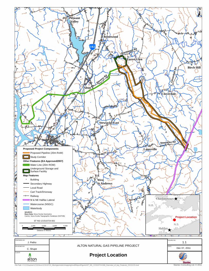
Northeast (M&NE) Pipeline Halifax Lateral (the Project), approximately 10.8 km away. Figure
1.1 (Project Location) shows the current proposed Project (i.e., the natural gas pipeline), as well
as the general location of the storage caverns and associated water pipelines that received EA
Approval in 2007.
The proposed natural gas pipeline will be 16 - 24 inches nominal outside diameter (OD) and
approximately 10.8 km in length. It will be designed, constructed, operated and maintained in
accordance with the 2011 edition of Canada Standards Association (CSA) CAN/CSA Z662 – Oil
and Gas Pipeline Systems Standard. The maximum operating pressure will be 9,930 kPa (1,440
psig). No compressor stations are anticipated along the pipeline route.
A pipeline corridor evaluation study was conducted and a preferred Study Corridor was selected
based on investigations to identify potential environmental, socio-economic, technical and cost
constraints. Alton selected a preferred 20 m right-of-way (referred to as the Proposed RoW)
within the Study Corridor based on refined constraint mapping and further investigation. This
proposed RoW selection process involved a number of field surveys, and discussions with
property owners and other stakeholders. The Study Corridor and Proposed RoW are shown on
Figure 1.2.
Proposed Project activities will be similar to those of other gas transmission pipeline projects in
Nova Scotia. Construction will include clearing, grubbing, topsoil stripping and grading,
trenching, welding, pipe installation, backfilling, and clean-up and RoW restoration. Operations
and maintenance will be limited to maintenance of the RoW and regular inspections and testing.
The natural gas pipeline will link the Alton storage caverns facility with the Maritimes and
Northeast Pipeline‘s (M&NE) natural gas transmission system Halifax Lateral. The M&NE
natural gas pipeline transports natural gas from Goldboro, Nova Scotia to the U.S. - Canada
border in Maine, terminating in Beverly, Massachusetts. The M&NE main pipeline interconnects

ALTON NATURAL GAS PIPELINE ENVIRONMENTAL ASSESSMENT REGISTRATION
INTRODUCTION
File: 121510724 1.2 July 2012
with the 323.94 mm (NPS 12‘) M&NE Halifax Lateral that is 124 km (77 mi) in length; this in turn
provides the connection between the Alton cavern site and the M&NE transmission system. A
Custody Transfer Meter Station located at the Halifax Lateral 70 km (44 mi) from the main line
will measure and control the flow of gas to and from the Alton gas pipeline that is the subject of
this EA application.
The Project will link the Alton storage caverns facility with the M&NE‘s natural gas transmission
system Halifax Lateral. The natural gas pipeline lateral was not included as part of the 2007
Environmental Assessment (EA) because at the time, it was not yet clear if Alton would be
building the lateral or if the lateral will be built, owned and operated by M&NE.
In Nova Scotia, EA is regulated under the province‘s Environment Act and Environmental
Assessment Regulations. The Project requires registration under the provincial environmental
assessment process as a Class I Undertaking because it meets the following criteria:
An onshore pipeline that is 5 km or longer, other than a pipeline that carries: natural gas, if
the pipeline has a maximum operating pressure below 3,450 kPa (500 psig)
The Halifax Lateral is a federally regulated undertaking and is subject to the National Energy
Board Act. As the Project will be constructed by Alton, a federal environmental approval process
under the Canadian Environmental Assessment Act (CEAA) with the National Energy Board
(NEB, the Board) is not anticipated.
This report describes and evaluates the potential environmental and socio-economic effects of
the Project during all Project phases. The evaluation has included proposed mitigative
measures, where required, to reduce or eliminate potential significant impacts arising from
Project-related activities. The report is based on information collected during field surveys,
consultation with government and non-government agencies and individuals, background
research and professional judgment of the Study Team.
ÃÆ
102
Brentwood
Brentwood Rd
AltonCloverdale
Stewiacke East
Lanesville
Forest Glen
Birch Hill
Clov
erdale
Rd
Stewiacke Rd
Stevens Rd
PleasantValley
WestSt Andrews
File Path: V:\1215\active\121510xxx\121510724_Alton\geomatics\mapping\mxd\ReportFigures\ST_NS_121510724-008_Overview_of_key_Features_20111123.mxd
Dec 07, 2011ALTON NATURAL GAS PIPELINE PROJECT
Project LocationREVIEWED BY: DATE:
C. Shupe
PREPARED BY:
J. PethoFIGURE NO.:
1.1
Stantec Consulting Ltd. © 2011
Proposed Project ComponentsProposed Pipeline (20m RoW)
Study Corridor
Other Features (EA Approved2007)Water Line (20m ROW)Underground Storage andSurface Facility
Map Features") Building
Secondary Highway
Local Road
Cart Track/Driveway
RailwayM & NE Halifax Lateral
Watercourse (NSGC)
Waterbody
ST NS-121510724-001
SOURCE:Base Data: Nova Scotia Geomatics Centre, Nova Scotia Topographic Database (NSTDB)
All
spat
ial d
ata
cont
ains
var
ying
leve
ls o
f inh
eren
t ina
ccur
acie
s. T
his
prod
uct w
as p
rodu
ced
for
the
sole
pur
pose
of s
uppo
rtin
g in
form
atio
n sp
ecifi
c to
a S
tant
ec p
roje
ct a
nd s
houl
d no
t be
used
for o
ther
pur
pose
s.
±
0 1,000 2,000 3,000 4,000
Distance in Metres
CLIENT:
^
^
Project Location
N.S.
N.B.
P.E.I.
HalifaxHalifax
Charlottetown

")
")
")
")
")
")")
")
")
")")
")")
")
")")
")
")")
")
")
")
")
")
")
")
")
")
")
")
")
")
")
")
")
")
")
")
")
")
")
")
")
")
")
")
")
")
")")
")
")
")
")
")
")")
")")
")
")
")
")
")
")")
")
")
")
")
")
")
")")
")
")
")
")
")
")
")
")
")
")
")
")
")
")
")
")
")
")
")
")
")
")
")
")")
")
")
")
")
")
")
")
")
")
")
")
")
")
")
")
")
")
")
")
")
")
")
")
")
")
")
")")
")
")
")
")
")
")
")
")
")
")
")
")
")
")
")
")
")
")
")
")
")
")
")
")
")
")
")
")
")
")
")
")
")
")
")
")
")")
")
")
")
")
")
")
")
")
")
")
")
")
")
")
")
")
")
")
")
")
")
")
")
")
")
")
")
")
")
")
")
")
")")
")")
")
")
")
")
")
")
")
")
")
")
")
")
")
")
")
")
")
")
")")
")
")
")
")
")
")
")
")
")
")
")
")
")
")
")
")
") ")
")
")
")
")
")
")
")
")
")
")
")
")
")
")
")
")
")
")
")
")
")
")
")
")
")
")
")
")
")
")
")
")
")
")
")
")
")")
")
")
")
")
")
")
")
")")
")
")
")
")
")")
")
")
")
")
")
")
")
")
")
")
")
")
")
")
")
")
")
")
")")
")
")
")
")
")")
")
")
")
")
")
")
")
")
")
")
")
")
")
")
")
")
")
")
")
")
")
")
")
")
")")
")
")
")
")
")
")
")
")
")
")
")
")
")
")
")
")
")
")
")
")
")
")
")
")
")
")")")
")
")
")
")
")
")
")
")
")
")")
")
")
")
")
")
")
")
")
")
")
")
")
")
")
")
")
")
")
")
")
")
")
")
")
")
")
")
")
")
")
")
")
")
")
")
")
")
")
")
")
")
")
")
")
")
")
")
")
")
")
")
")
")
")
")
")
")
")
")
")
")
")
")
")
")
")
")
")
")
")
")
")
")
")
")
")
")
")")
")
")
")
")")
")
")
")
")
")
")
")
")
")
")
")
")
")
")
")
")
")
")
")
")
")
")
")
")
")
")
")
")
")
")
")
")
")
")
")
")")
")
")
")
")
")
")
")")
")
")")
")
")
")
")
")
")
")
")
")
")
")
")
")
")
")
")
")
")
")
")
")
")
")
")
")
")
")
")
")
")
")
")
")
")
")
")
")
")
")
")
")
")
")
")
")
")
")
")
")")
")
")
")
")
")
")
")
")
")
")
")
")
")
")
")
")
")
")
")
")
")
")
")
")
")
")
")
")
")
")
")
")
")
")
")
")")
")
")
")
")
")")
")
")
")
")
")
")
")
")
")
")
")
")
")
")
")
")
")
")
")
")
")")
")
")
")
")
")
")
")
")
")
")
")
")
")
")
")
")
")
")
")
")
")
")
")
")
")
")")
")
")
")
")
")
")
")
")
")
")
")
")
")
")
")
")
")
")
")")
")
")
")
")
")
")
")
")
")
")
")
")
")
")")
")
")
")")
")
")
")")
")
")
")
")
")
")
")
")
")
")
")
")
")
")
")
")
")
")
")
")
")
")
")
")")
")
")
")
")
")
")
")
")
")
")
")
")
")
")
")
")
")
")
")
")
")
")
")
")
")
")
")
")
")
")
")
")
")
")
")
")
")
")
")
")
")
")
")
")
")
")
")
")
")
")
")
")
")
")
")
")
")
")
")
")
")
")
")
")
")
")
")
")
")
")
")
")
")
")
")
")
")
")
")
")
")
")
")
")
")
")
")
")
")
")
")
")
")
")
")
")
")
")
")
")
")
")
")
")
")
")
")
")
")
")
")
")
")
")
")
")
")
")
")
")
")
")
")
")
")
")
")
")
")
")
")
")
")
")
")
")
")
")")
")
")
")
")
")
")
")
")
")
")
")
")
")
")
")
")
")
")")
")
")
")
")
")
")
")
")
")
")
")
")
")
")
")
")
")
")
")")
")
")
")
")
")
")
")
")
")
")
")
")
")
")
")
")
")
")
")
")
")
")
")
")
")
")
")
")
")
")
")")
")
")
")
")
")
")
")
")
")
")
")
")
")
")
")
")
")
")
")
")
")
")
")
")
")
")
")
") ")
")
")
")
")
")
")
")
")
")
")
")
")
")
")
")
")")
")")
")
")
")
")
")
")
")
")
")
")
")
")
")
")
")
")
")
")
")
")
") ")")
")
")
")
")
")
")
")
")
")
")")
")
")
")
")
")
")
")
")
")
")
") ")
")
") ")
")
")")
")")
")
")
")
")
")
")
")
")
")
")
")
")
")
")")")
")
")
")
")
")
")")
")
")
")
")
")
")
")
")
")
")
")
")
")")
")
")
")
")
")
")
")
")
")
")
")
")
")
")
")
")
")
")
")
")
")
")")
")
")
")
")
")
")
")
")
")
")
")
")
")
")
")
")")
")")
")
")
")
")
")
")
")
")
")
")
")
")
")
")
")
")
")
")
")")
")
")
")
")
")
")
")
")
")")
")
")
")
")
")
")
")
")
")
")
")
")
")
")
")
")
")
")
")
")")
")
")
")
")
")
")
")
")
")
")
")
")
")
")")
")
")
")
")
")
")
")
")
")
")
")
")
")
")
")
")
")
")")
") ")
")
")
")
")
")
")
")
")
")
")
")
")
")
")
")")
")
")
")
")
")
")
")
")
")
")
")
")
")
")
")
")
")
")
")
")
")
")
")
")
")
")
")
")
")
")")
")
")
")
")
")
")
")
")
")
")
")
")
")
")
")
")")
")
")")
")
")
")
")
")
")
")
")
")
")
")
")
")
")
")")
")
")
")
")
")
")
")
")
")
")")
")
")")
")
")
")
")
")")
")
")
")
")
")
")
")
")
")
")
")
")
")
")
")
")
")
")
")
")
")
")
")
")
")
")
")
")
")
")
")
")
")
")
")
")
")
")
")
")
")
")
")
")
")
")
")
")
")
")
")
")
")
")
")
")
")
")
")
")
")
")
")
")
")
")
")
")
")
")
")
")
")
")
")
")
")
")
")
")
")
")
")
")
")
")")
")
")
")
")
")
")
")
")
")
")
")
")
")
")
")
")
")
")
")
")
")
")
")
")
")
")
")
")
")")
")
")
")
")
")
")
")
")
")
")")
")
")
")
")
")
")
")
")
")
")
")
")
")
")
")
")
")
")
")
")
")
")
")
")
")
")
")
")
")
")
")
")
")
")
")
")
")
")
")
")
")
")
")
")
")
")
")
")
")
")
")
")
")
")
")
")
")
")
")
")
")
")
")
")
")
")
")
")
")
")")")")")")")
")") ")")
")
")
")
")")
")
")
")")
")
")
")")
")
")
")
")
")
")
")
")
")
")
")
")
")
")
")
")
")
")
")
")
")
")
")
")
")
")
")
")
")
")
")
")
")
")
")
")
")
")
")
")
")
")
")
")
")
")
")
")
")
")
")
")
")
")
")
")
")
")
")
")
")
")
")
")
")
")
")
")
")
")
")")
")")
")
")
")
")
")
")
")
")
")
")
")")
")
")
")
")
")
")
")
")")
")ÃÆ
102
Brentwood
Brentwood Rd
Alton
Cloverdale
Stewiacke East
Lanesville
Forest Glen
Birch Hill
Clove
rdale
Rd
Stewiacke Rd
Stevens Rd
File Path: V:\1215\active\121510xxx\121510724_Alton\geomatics\mapping\mxd\ReportFigures\ST_NS_121510724-001_Project_Overview.mxd
Dec 07, 2011ALTON NATURAL GAS PIPELINE PROJECT
Study Corridor and Proposed Pipeline Right-of-Way
REVIEWED BY: DATE:
C. Shupe
PREPARED BY:
J. PethoFIGURE NO.:
1.2
Stantec Consulting Ltd. © 2011
Project ComponentsProposed Pipeline (20m RoW)Study Corridor
Map Features") Building
Secondary HighwayLocal RoadCart Track/DrivewayRailwayM & NE Halifax Lateral
Watercourse (NSGC)Waterbody
ST NS-121510724-001
SOURCE:Base Data: Nova Scotia Geomatics Centre, Nova Scotia Topographic Database (NSTDB)
All
spat
ial d
ata
cont
ains
var
ying
leve
ls o
f inh
eren
t ina
ccur
acie
s. T
his
prod
uct w
as p
rodu
ced
for
the
sole
pur
pose
of s
uppo
rtin
g in
form
atio
n sp
ecifi
c to
a S
tant
ec p
roje
ct a
nd s
houl
d no
t be
used
for o
ther
pur
pose
s.
±
0 500 1,000 1,500 2,000
Distance in Metres
CLIENT:

ALTON NATURAL GAS PIPELINE ENVIRONMENTAL ASSESSMENT REGISTRATION
INTRODUCTION
File: 121510724 1.6 July 2012
1.4 PROJECT BACKGROUND
Previously EA Approved Project - Storage Caverns and Water Pipeline
In December 2007, the Alton Natural Gas Storage Project received an EA Approval (with
conditions) from the Nova Scotia Minister of Environment for the development of the storage
caverns. Subsequent to the EA Approval, several other permits were also obtained under Part V
of the Nova Scotia Environment Act, including Industrial Approvals and Water Approvals (refer
to Figure 1.1) for several phases of the cavern development project.
The Alton storage caverns will be located within the confines of the Hydrocarbon Storage-Area
Lease obtained by Alton, while the surface facilities will be located within surface lands owned
or leased by Alton. The Alton cavern site has a number of advantages including its subsurface
geological properties, access to existing natural gas pipeline infrastructure, and proximity to
valuable markets in eastern Canada and the north-eastern USA.
Key features of cavern development (as per 2007 EA) include:
A buried water pipeline to the area overlaying the salt formation from the Shubenacadie
Estuary (the Estuary), at a distance of approximately 12 km, where water will be drawn to
the facility for solution mining, with a second pipeline to transport brine returned to the
Estuary during the cavern development process;
Cavern development facilities including water pumping, brine handling, measurement and
control systems, and buffer fluid systems for cavern shape control;
Pipeline systems from the cavern development facilities to the cavern access wells; and
Cavern access wells through which leaching water flows to the salt zone where the caverns
are developed, the resulting brine returns, and buffer fluid enters and exits the cavern
Gas handling facilities including compression, dehydration, metering and control, and
ancillary equipment will be located in a central gas handling facility located near the caverns
and on Alton lands.
In June 2011, Alton submitted an Application for Approval to Construct the Alton Natural Gas
Storage Cavern Development to the Nova Scotia Utility and Review Board which forms part of
the overall application. This application was submitted to confirm that the cavern development
will adequately conform to the Province of Nova Scotia‘s ―Code of Practice Respecting the
Underground Storage of Hydrocarbons (December 2002)‖ that regulates the design,
development and operation of underground natural gas storage caverns in the province, as well
as the national standard CAN/CSA Z341 ―Storage of Hydrocarbons in Underground
Formations‖, Series-10 (February 2010).

ALTON NATURAL GAS PIPELINE ENVIRONMENTAL ASSESSMENT REGISTRATION
INTRODUCTION
File: 121510724 1.7 July 2012
Current Proposed Project – Natural Gas Transmission Pipeline
In order to transport natural gas to and from storage, the facility requires a natural gas
transmission pipeline. The subject of the current EA registration is a natural gas pipeline that will
connect the caverns and facilities to the M&NE Halifax Lateral approximately 10.8 km away,
which connects to a larger network of pipelines that supply natural gas to the Maritimes and
others (refer to Figure 1.2).
1.5 REGULATORY FRAMEWORK
In Nova Scotia, EA is regulated under the province‘s Environment Act and Environmental
Assessment Regulations. The Project triggers the provincial EA process as a Class I
Undertaking.
An onshore pipeline that is 5 km or longer, other than a pipeline that carries: natural gas, if
the pipeline has a maximum operating pressure below 3450 kPa (500 psig)
This EA report, prepared on behalf of Alton by Stantec Consulting Ltd. (Stantec), is intended to
support the required EA Registration for the Project made pursuant to the Environmental
Assessment Regulations.
The Halifax Lateral is a federally regulated undertaking and is subject to the National Energy
Board Act. As the Project will be constructed by Alton, a federal environmental approval process
under the Canadian Environmental Assessment Act (CEAA) with the National Energy Board
(the Board) is not anticipated. No triggers for an assessment under CEAA are anticipated for
this Project, namely: federal proponent; federal funds; transfer of interest in federal lands; or
permits/authorizations under the CEAA Law List Regulations.
Overall, the Project will be developed and operated in a manner that reduces adverse effects on
the environment and provides economic benefits to Colchester County and the Province of
Nova Scotia.
1.6 ORGANIZATION OF THE REPORT
Following this introduction, this EA includes the following sections:
A description of the proposed Project (Section 2.0);
A description of the methods of public involvement and steps taken to address public
concerns (Section 3.0);
The scope of the assessment and the methodology used to assess the environmental
effects (Section 4.0);
A description of the existing environmental and socio-economic setting of the Project
(Section 5.0);

ALTON NATURAL GAS PIPELINE ENVIRONMENTAL ASSESSMENT REGISTRATION
INTRODUCTION
File: 121510724 1.8 July 2012
The environmental and socio-economic components effects assessment, including
proposed and required mitigation and monitoring and follow-up studies (Section 6.0);
A description of potential malfunctions and accidental events (Section 7.0);
A summary of the report and concluding statements (Section 8.0);
A list of references cited including literature and personal communications (Section 9.0); and
Several appendices of technical information.

ALTON NATURAL GAS PIPELINE ENVIRONMENTAL ASSESSMENT REGISTRATION
File: 121510724 2.1 July 2012
2.0 PROJECT DESCRIPTION
2.1 PROJECT LOCATION AND ROUTE SELECTION
The Project will be located within a 20 m wide right-of-way (RoW) extending approximately 10.8
km in a continuous route from the underground caverns site near Alton, NS, to a tie-in to the
Halifax Lateral pipeline (refer to Figure 1.2).
A pipeline corridor evaluation study was conducted in 2007 to identify a preferred Study Corridor
(approximately 1 km wide) from a larger study area (approximately 10 km wide) based on
potential environmental, socio-economic, technical and cost constraints. Four potential Study
Corridors were assessed: the preferred Southern Corridor; two Alternate Corridors that are
variants of the Southern Corridor; and an Eastern Corridor (refer to Figures 2.1 and 2.2). The
following constraints were reviewed at a high level for each of the four potential pipeline
corridors:
Geological and geotechnical conditions known to affect pipeline constructability and integrity
(e.g., steep slopes, and exposed or shallow bedrock);
Watercourse crossings and fisheries resources requiring special consideration (e.g.,
potential for wet crossings and/or horizontal directional drilling (HDD));
Terrestrial resources requiring special consideration (e.g., high value habitat, concentration
of sensitive species, wetlands);
Land use (e.g., First Nations reserves, parks and protected areas, developed areas,
proximity to residents, and land use planning); and
Archaeological/cultural sites.
M&NE also added criteria with respect to preferred conditions at the tie-in to the Halifax Lateral;
these are: easy accessibility, readily available electric power supply and telephone service, and
access to land.
Potential constraints were identified through a desktop review of existing information, including
readily available technical reports, databases, professional judgment and experience locating
linear development projects in Canada. The review identified potential environmental, technical,
and social issues or constraints in the area, based on readily available data. Sources of these
data include the Maritimes Breeding Bird Atlas, Nova Scotia Department of Natural Resources,
Species at Risk Act Registry, Canada Land Inventory, Atlas of Canada, official plans and other
regional sources of information, where available for the area.
ALTON NATURAL GAS PIPELINE ENVIRONMENTAL ASSESSMENT REGISTRATION
PROJECT DESCRIPTION
File: 121510724 2.2 July 2012
The Southern Corridor was selected as the preferred option in consideration of the following
factors:
As shown on Figure 2.1, the Southern Corridor traverses fewer environmentally sensitive
areas, particularly government-identified wetlands, than the Eastern Corridor;
The properties crossed by the Southern Corridor was owned by only six private landowners,
whereas the properties crossed by the Eastern Corridor were owned by 33 different
landowners (refer to Figure 2.2);
The Southern Corridor maintains greater setback distances from residential properties than
the Eastern Corridor (refer to Figure 2.2); and
The length of the Southern Corridor (approximately 10.8 km) is shorter than the length of the
Eastern Corridor (approximately 13 km). The Southern Corridor is preferable from this
perspective because selection of a shorter pipeline route is generally expected to translate
into relatively less environmental disturbance during Project construction and reduced
potential for adverse environmental effects caused by accidental events.
The two potential Alternate Corridors branching off of the Southern Corridor were excluded due
to the absence of one or more of M&NE‘s above-listed criteria for a preferred interconnection
point.
Following identification of the Southern Corridor as the preferred Study Corridor, Alton
conducted a pipeline constructability investigation/review that did not identify any unmanageable
constraints. A meeting was subsequently held with Nova Scotia Environment‘s (NSE) on June
25, 2008 to review the Southern Corridor proposal, and no serious issues were raised at that
time. All further investigation and analysis undertaken in support of the Project and this EA
focused in the Southern Corridor.
Alton selected a preferred 20 m wide right-of-way (referred to as the Proposed RoW) within the
Study Corridor based on refined constraint mapping and further investigation. This Proposed
RoW selection process involved a number of field surveys, and discussions with property
owners and other stakeholders. Further details on the Study Corridor and Proposed RoW
selection can be found in Sections 3.0 (Public Involvement), 5.0 (Existing Environment), and 6.0
(Environmental and Socio-Economic Effects Assessment).
Nova Scotia has set a goal to protect 12% of the land in Nova Scotia by 2015 and selected the
candidate lands, mainly Crown lands, for consideration under the program (NSE 2011). The
majority of Crown land within the Study Corridor falls under the 12% candidate lands; however
these candidate lands were identified in 2011 after the Study Corridor was identified. These
lands are discussed further in Section 5.7.5 (Land and Resource Use).

R I V E R
STEW
IAC
KE
Little River
Watering Brook
BREN
TWOO
D RD
ÃÆ
102
Birch Hill
Clove
rdale
Rd
Cloverdale
Forest Glen
Stevens Rd
PleasantValley
LanesvilleStewiacke Rd
Stewiacke East
Brentwood
Alton
ALTON NATURAL GAS PIPELINE PROJECT
Pipeline Corridor Selection - Biophysical ConsiderationsREVIEWED BY: DATE:
R. Federico
PREPARED BY:
M. Huskins-ShupeFIGURE NO.:
2.1
Stantec Consulting Ltd. © 2011
ST NS-121510724-014
SOURCE:Base Data: Nova Scotia Geomatics Centre, Nova Scotia Topographic Database (NSTDB)Forest Habitat: NSDNR, Forest Inventory, 2010.
All
spat
ial d
ata
cont
ains
var
ying
leve
ls o
f inh
eren
t ina
ccur
acie
s. T
his
prod
uct w
as p
rodu
ced
for
the
sole
pur
pose
of s
uppo
rtin
g in
form
atio
n sp
ecifi
c to
a s
tant
ec p
roje
ct a
nd s
houl
d no
t be
used
for
othe
r pu
rpos
es.
0 500 1,000 1,500 2,000250
Distance in Metres
Pipeline FeaturesSouthern Corridor (Preferred)
Eastern Corridor
Alternate CorridorsAlton Gas Proposed Surface& Subsurface Facilities
Project ComponentsStudy Features
M&NE Halifax Lateral
WetlandsStudy Area
Map Features" Buildings and Residences
Secondary Highway
Local RoadCart Track/Driveway
Seasonal/ Resource Road
RailwayDitch
Watercourse (NSGC)
WaterbodyProperty Boundary
±
CLIENT:
Jun 13, 2012
File Path: V:\1215\active\121510xxx\121510724_Alton\geomatics\mapping\mxd\ReportFigures\ST_NS_121510724-014_Prop_Pipeline_Biophysical.mxd
Coordinate System: NAD 1983 UTM Zone 20N


R I V E R
STEW
IAC
KE
Little River
Watering Brook
BREN
TWOO
D RD
ÃÆ
102
Birch Hill
Clove
rdale
Rd
Cloverdale
Forest Glen
Stevens Rd
PleasantValley
LanesvilleStewiacke Rd
Stewiacke East
Brentwood
Alton
ALTON NATURAL GAS PIPELINE PROJECT
Pipeline Corridor Selection - Land Use ConsiderationsREVIEWED BY: DATE:
R. Federico
PREPARED BY:
M. Huskins-ShupeFIGURE NO.:
2.2
Stantec Consulting Ltd. © 2011
ST NS-121510724-013
SOURCE:Base Data: Nova Scotia Geomatics Centre, Nova Scotia Topographic Database (NSTDB)Forest Habitat: NSDNR, Forest Inventory, 2010.
All
spat
ial d
ata
cont
ains
var
ying
leve
ls o
f inh
eren
t ina
ccur
acie
s. T
his
prod
uct w
as p
rodu
ced
for
the
sole
pur
pose
of s
uppo
rtin
g in
form
atio
n sp
ecifi
c to
a s
tant
ec p
roje
ct a
nd s
houl
d no
t be
used
for
othe
r pu
rpos
es.
0 500 1,000 1,500 2,000250
Distance in Metres
Pipeline FeaturesSouthern Corridor (Preferred)
Eastern Corridor Alternate CorridorsAlton Gas Proposed Surface& Subsurface Facilities
Project Components
Study FeaturesM&NE Halifax LateralCandidate 12% ProvincialConservation Areas
Study Area
Map Features" Buildings and Residences
Secondary Highway
Local RoadCart Track/Driveway
Seasonal/ Resource Road
RailwayDitch
Watercourse (NSGC)
WaterbodyProperty Boundary
±
CLIENT:
Jun 13, 2012
File Path: V:\1215\active\121510xxx\121510724_Alton\geomatics\mapping\mxd\ReportFigures\ST_NS_121510724-013_Prop_Pipeline_LandUse.mxd
Coordinate System: NAD 1983 UTM Zone 20N


ALTON NATURAL GAS PIPELINE ENVIRONMENTAL ASSESSMENT REGISTRATION
PROJECT DESCRIPTION
File: 121510724 2.5 July 2012
2.2 PROJECT INFRASTRUCTURE AND ACTIVITIES
2.2.1 Project Design Overview
Components of the proposed Project include:
Approximately 10.8 km of NPS 16 - 24 steel buried pipeline designed to a maximum
operating pressure of 9,930 kPa (1,440 psig) (see Table 2.1). The pipeline will be designed
to allow for pigging capabilities using internal inspection tools. The pipeline will be designed,
constructed, operated and maintained in accordance with the 2011 edition of CAN/CSA
Z662 - Oil and Gas Pipeline Systems.
The proposed pipeline will require a 20 m wide permanent RoW with additional temporary
work spaces in all crossing locations. The work space required will vary depending upon the
size and nature of the crossing.
Valve stations will be installed at each end of the pipeline along with facilities for flow
control, gas metering and isolation capabilities for maintenance and safety requirements.
The valve stations will be fenced for security purposes. The valve station at the caverns site
was assessed as part of the 2007 EA (Jacques Whitford 2007).
TABLE 2.1 Line Pipe Specifications
Specification CAN/CSA Z245.1
Nominal Diameter (inches) NPS 16 to NPS 24
Minimum Burial Depth m 0.91
External Coating Extruded HDPE or Fusion Bonded Epoxy
Design Pressure (kPa) 9,930
Joint Type Welded
External Coating at Joints Per coating manufacturer‘s instructions
Wherever practical, the pipeline will parallel existing lateral disturbances (e.g., woods roads)
and utilize existing infrastructure for construction purposes. Contractor marshaling yards will be
located on commercial property. A few new access roads (temporary or permanent) will be
necessary for the construction of this pipeline and associated facilities. The location of new
access roads and additional work areas will be determined prior to construction using
environmental siting procedures similar to those used to locate the Proposed RoW.
2.2.2 Construction
The following is a general description of typical pipeline construction activities. Further detail will
be provided in the Environmental Management Plan (EMP), which will be prepared at the
Industrial Approval stage. An outline of the EMP is provided in Section 2.8.5. The EMP will
serve as an umbrella document that includes information such as the Waste Management Plan
(WMP), Environmental Protection Plan (EPP) and the Emergency Response and Contingency
Plan, as well as other key environmental planning documents.

ALTON NATURAL GAS PIPELINE ENVIRONMENTAL ASSESSMENT REGISTRATION
PROJECT DESCRIPTION
File: 121510724 2.6 July 2012
Inspection staff will enforce Alton‘s construction specifications, site-specific environmental
mitigation measures contained in the EMP, and any conditions imposed by regulatory
authorities. Environmental Inspectors will be experienced in pipeline construction and hired to
perform this task. The EMP will also include additional information on the Environmental
Inspectors‘ roles and responsibilities.
All landowner or industry issues and crossing agreements are to be resolved prior to making the
NSUARB application for approval to construct the pipeline.
Before the contractor's work force enters onto any private property, an Alton representative will
contact each landowner to discuss specific issues regarding the Project. Appropriate mitigative
measures to address landowner concerns may involve temporary fencing, access through
existing private trails to the work area, topsoil conservation, cut timber disposal, and
revegetation. Discussions with landowners will be recorded and a copy of agreed mitigation
measures is left with the landowner and provided to the pipeline contractor. A card will be left
with the landowner with telephone numbers of Alton personnel who can be reached during
construction.
Site Preparation
The pipeline RoW will traverse and intersect several existing public and private roads and
forestry roads. It is anticipated that access to the RoW for construction will be from these points
and few if any new access roads will be built for this Project. Where required, access roads will
be built as temporary access routes and will consider the applicable local or provincial
standards or guidelines for this use. Environmental protection measures similar to those used
for RoW construction will be applied to access road construction thus avoiding or reducing
potential adverse effects from road construction (see Section 2.8.5 for EMP outline).
All utilities (e.g., existing pipelines, telephone lines, power lines) are located or ―daylighted‖ to
avoid damage to the utility and hazards to construction workers.
The clearing crew is the first to begin work on the RoW. The crew braces and cuts all fences
crossing the RoW and installs temporary gates as required. The crew clears trees, stumps,
brush, and crops from the RoW to permit construction of the pipeline. Merchantable timber is
salvaged and property owners are compensated for any trees that are removed. Clearing will be
restricted to the 20 m RoW and temporary work spaces.
The next step is for the grading crew who prepare temporary approaches to transportation
corridors to allow equipment the required access to the RoW. This crew grades the entire RoW
to prepare for pipeline construction and strips and conserves topsoil from the ditch line such that
different soil types are not mixed. The various soil types along the proposed RoW will be
identified in the EMP (see outline in Section 2.8.5) which will form an integral part of the contract
documents and identify mitigative measures to be taken.

ALTON NATURAL GAS PIPELINE ENVIRONMENTAL ASSESSMENT REGISTRATION
PROJECT DESCRIPTION
File: 121510724 2.7 July 2012
Pipeline Installation
This pipeline will likely be constructed utilizing one pipeline spread comprised of several crews
with different responsibilities. The work will be supervised by Alton representatives.
Line pipe is delivered to the RoW by trucks with flatbed trailers. The stringing crew is
responsible for the offloading of the individual pipe joints and positioning them along the RoW
on skids in preparation for the next crew.
The bending crew is the next on the RoW. Their responsibility is to bend individual joints of pipe
in order to allow the completed pipeline to match the contours of the RoW (lateral, vertical and
compound deflections).
Welding of the individual pipe joints is the next step in the process and is handled by the
welding crew. This crew can be comprised of rig welders and/or automatic welders. Each
welded joint will require several welding passes to complete the weld and grinding and cleaning
of the weld area is required between passes.
Following the welding crews is another group of workers tasked with cleaning the welded joint
and applying the necessary coating to the weld area as recommended by the pipe coating
manufacturer to complete the external corrosion protection.
Using backhoe excavators or trenching machines, the contractor excavates a trench,
approximately one metre wide and about 1.5 metres deep, to provide the required cover over
the pipe. The contractor will provide access across the trench and work area as required for
property owners.
In rock areas, pipeline cover requirements may be reduced in accordance with code
requirements; however, no such areas have been identified during route surveying and
assessments.
Concurrent with trenching, a boring crew prepares all transportation corridors as necessary for
bored crossings. This operation involves an excavation on both sides of the proposed crossing
large enough to allow room for the boring equipment to operate and at the proper elevation.
Augers placed in a bore pipe are used to bore beneath the proposed crossing to avoid
disrupting surface features at the crossing site. When the bore pipe exits on the far side of the
crossing, the augers are removed, the carrier pipe or casing pipe is attached to the bore pipe,
and the bore pipe is pulled back, drawing the carrier pipe or casing pipe into place. Typically,
paved highways and main roads are bored; smaller road crossings may be crossed using an
open-cut method. If a road is open-cut, the trench is backfilled as quickly as possible to maintain
access.
In the unlikely circumstance that substantial bedrock is encountered, blasting may be required
to permit trench excavation for the pipeline. All blasting activity is carried out by licensed
blasting personnel to protect the general public, personnel and property.
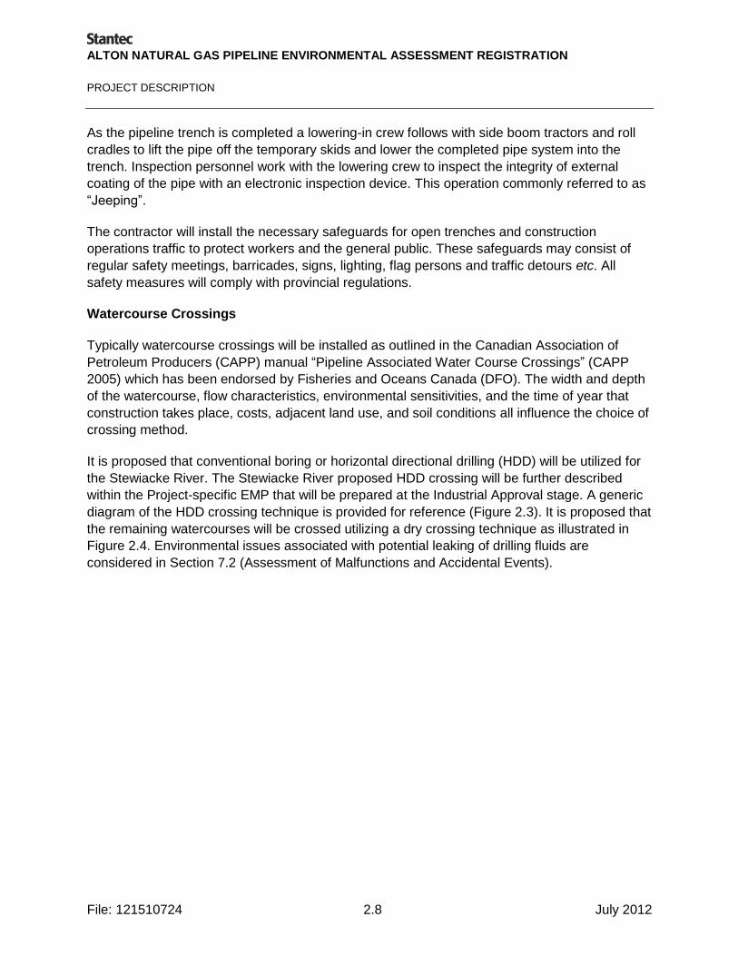
ALTON NATURAL GAS PIPELINE ENVIRONMENTAL ASSESSMENT REGISTRATION
PROJECT DESCRIPTION
File: 121510724 2.8 July 2012
As the pipeline trench is completed a lowering-in crew follows with side boom tractors and roll
cradles to lift the pipe off the temporary skids and lower the completed pipe system into the
trench. Inspection personnel work with the lowering crew to inspect the integrity of external
coating of the pipe with an electronic inspection device. This operation commonly referred to as
―Jeeping‖.
The contractor will install the necessary safeguards for open trenches and construction
operations traffic to protect workers and the general public. These safeguards may consist of
regular safety meetings, barricades, signs, lighting, flag persons and traffic detours etc. All
safety measures will comply with provincial regulations.
Watercourse Crossings
Typically watercourse crossings will be installed as outlined in the Canadian Association of
Petroleum Producers (CAPP) manual ―Pipeline Associated Water Course Crossings‖ (CAPP
2005) which has been endorsed by Fisheries and Oceans Canada (DFO). The width and depth
of the watercourse, flow characteristics, environmental sensitivities, and the time of year that
construction takes place, costs, adjacent land use, and soil conditions all influence the choice of
crossing method.
It is proposed that conventional boring or horizontal directional drilling (HDD) will be utilized for
the Stewiacke River. The Stewiacke River proposed HDD crossing will be further described
within the Project-specific EMP that will be prepared at the Industrial Approval stage. A generic
diagram of the HDD crossing technique is provided for reference (Figure 2.3). It is proposed that
the remaining watercourses will be crossed utilizing a dry crossing technique as illustrated in
Figure 2.4. Environmental issues associated with potential leaking of drilling fluids are
considered in Section 7.2 (Assessment of Malfunctions and Accidental Events).
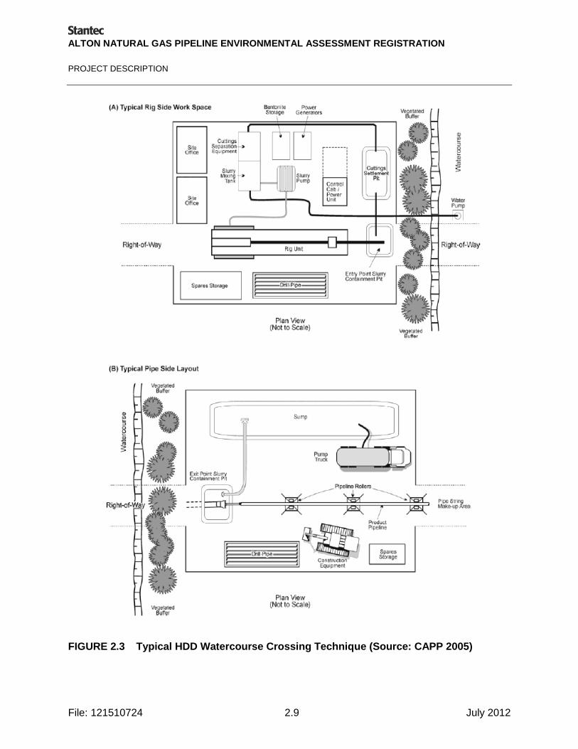
ALTON NATURAL GAS PIPELINE ENVIRONMENTAL ASSESSMENT REGISTRATION
PROJECT DESCRIPTION
File: 121510724 2.9 July 2012
FIGURE 2.3 Typical HDD Watercourse Crossing Technique (Source: CAPP 2005)

ALTON NATURAL GAS PIPELINE ENVIRONMENTAL ASSESSMENT REGISTRATION
PROJECT DESCRIPTION
File: 121510724 2.10 July 2012
FIGURE 2.4 Typical Dam and Pump Watercourse Crossing Technique (Source: CAPP 2005)
Backfilling of the trench commences immediately after the pipe has been installed. This
backfilling operation is carried out using a dozer or backhoe. In areas of steep slopes, ditch
plugs, RoW cross drains and diversion berms are installed at regular intervals to prevent trench
and surface erosion and promote re-vegetation.
Additional mitigation measures for watercourse crossings are provided in Section 6.2.5.
Right-of-Way Restoration
The clean-up crew is the final crew on the property. The crew prepares the subsoil on the
stripped portion of the RoW. The trench line is crowned with enough subsoil to allow for trench
settlement. The topsoil is replaced over the stripped area, graded, harrowed and reseeded as
required. The clean-up crew also repairs fences, picks up debris, and restores sensitive areas
such as steep slopes, ditch banks, and stream crossing areas. Final clean-up typically occurs
after the following spring, when settlement or other issues may show up.
Large rock not suitable for use as backfill material will be disposed of, either by windrowing
along the edge of the RoW, buried on or off the RoW, or hauled off the RoW depending upon

ALTON NATURAL GAS PIPELINE ENVIRONMENTAL ASSESSMENT REGISTRATION
PROJECT DESCRIPTION
File: 121510724 2.11 July 2012
the requirements of the property owner. In bedrock areas rock is used to backfill the trench level
with the existing bedrock profile. In such areas, the pipe is protected with rock shield or shaded
with sand fill prior to backfilling.
When clean-up is completed, the landowner and an Alton representative conduct a RoW review
to assess conditions. The landowner is asked to sign a clean-up acknowledgment form if
satisfied with the clean-up. When signed, this form releases the contractor, allowing payment for
the clean-up on the property, but in no way releases Alton from its obligation to compensate for
damages or to rehabilitate disturbance directly attributable to the pipeline construction.
2.2.3 Cleaning and Testing
The completed pipeline is hydrostatically tested with water to ensure pipeline integrity and
confirm it is suitable for the intended service and operating pressures. Water for testing is
normally obtained from water sources near the pipeline, including streams or lakes, or available
municipal supply lines. Water withdrawal sites are selected in accordance with environmental
guidelines and the requirements of regulatory agencies and landowners affected by the
operation. All necessary permits will be obtained from regulatory authorities for the use of water
from the selected withdrawal sites.
Once the pipeline test is complete the pipeline is dewatered and dried with in-line mechanical
tools called "pigs". The test water is collected and disposed of only at approved locations and in
accordance with the regulations and in consultation with the landowners. Water is generally
released over land at low velocities to prevent flooding or erosion. If released directly to
streams, care is taken to prevent scouring of the stream or river beds and banks, and, where
practicable, the water is returned to the same source. Any methanol used in testing for freeze
protection will be recovered and disposed in accordance with local and provincial regulations.
Alton will consider practice guidance from government and industry and implement it as
appropriate during fluid selection, testing operations, and disposal of waste fluid.
2.2.4 Custody Transfer Station
A custody transfer metering station will be constructed at the tie-in point of the 16 to 24‖ steel
gas pipeline and the 12‖ M&NE Halifax Lateral. M&NE will build and own the station. This
station will measure and control the natural gas flow to and from the storage cavern system. An
Emergency Shutdown (ESD) system will allow for the isolation of the Alton Gas Pipeline in case
of an emergency.
2.3 OPERATION AND MAINTENANCE
Alton will operate and maintain the pipeline in accordance with standard procedures designed to
ensure the integrity of the system, including those specified by CAN/CSA Z662. The pipeline is
designed for a minimum 40-year life, although the actual life would probably be much longer.
The pipeline will be patrolled by Alton on a routine basis and required maintenance will be

ALTON NATURAL GAS PIPELINE ENVIRONMENTAL ASSESSMENT REGISTRATION
PROJECT DESCRIPTION
File: 121510724 2.12 July 2012
handled by qualified personnel. Commercial air services may be used as required for routine
inspection of the pipeline.
The pipeline RoW will be clearly marked with sign and post markings at public roads, railroad
and navigable water crossings, and other areas as required to reduce the possibility of damage
or interference resulting from construction activities of other projects. This will also allow the
rapid identification of the pipeline during aerial surveillance. Prior to commissioning the pipeline,
Alton will file an Operations Manual with the NSUARB. This manual will take into consideration
current and ongoing discussions with regulatory agencies, stakeholders, and community groups
to ensure consideration of local needs.
Typical maintenance or routine activities during pipeline operation may include internal pipeline
inspections using ―Smart Pigs‖ (electronic inspection tools), annual aerial surveillance, over the
ground surveys, and cathodic protection monitoring. Excavation, inspection, and replacement of
pipe segments will be undertaken, if necessary.
The pipeline RoW will traverse a number of different terrain types and environmental conditions.
RoW maintenance procedures will be consistent with Alton‘s existing procedures and those
used by other major pipeline companies across Canada, with specific modifications made for
the region. Maintenance will be performed by Alton personnel and equipment and/or qualified
contractors.
Vegetation control on the RoW will be accomplished by mechanical means. No chemical
spraying will be undertaken on the RoW; however, limited chemical spraying may be used,
where allowed by regulation, to control vegetation growth within the confines of meter stations
and other station facilities. The use of herbicides for vegetation control may be required in areas
where physical vegetation management techniques are unsuccessful at controlling noxious
weeds. Only herbicides of low persistence and low ecological toxicity will be used and no
chemical vegetation control will be performed within or adjacent to wetlands or within 30 m of
watercourses.
Pipeline valves and aboveground facilities will be properly secured and protected by suitable
fences to prevent tampering by unauthorized parties. The fenced areas will be maintained to
ensure safety and an acceptable appearance.
Additional safety measures are described in Section 2.8.5.
2.4 DECOMMISSIONING
Alton facilities are designed and will be operated and maintained to provide safe and efficient
service for a minimum of 40 years and likely much longer. However, if unforeseen events occur,
some facilities may eventually need to be decommissioned. Should decommissioning be
required, options include leaving pipeline structures in place, or removing them. If abandonment
of the structures is chosen, it will be undertaken in accordance with the regulatory requirements
applicable at the time of such activities and appropriate technology will be used. An

ALTON NATURAL GAS PIPELINE ENVIRONMENTAL ASSESSMENT REGISTRATION
PROJECT DESCRIPTION
File: 121510724 2.13 July 2012
abandonment plan and, if required, a site restoration plan, will be developed in consultation with
the Nova Scotia UARB and other appropriate regulatory authorities.
At a minimum, an abandonment plan would include a schedule for equipment decommissioning
and disassembly. The plan would indicate the approximate time required to remove and dispose
all abandoned installations, structures, and buildings for which onsite reuse is not possible, and
to reinstate the site to a quality necessary for subsequent industrial land use. Decommissioning
planning will be developed in consideration of environmental goals for the area. Activities that
support such planning may include a review of baseline and follow up monitoring data; thorough
record keeping; adherence to applicable standards and guidelines during Project operations;
documentation of potential influencing factors; and development of a rehabilitation plan.
To protect the public and the environment, surface facilities, particularly valves and metering
devices, will be removed. Sites will meet legislative standards and will be left clean and safe.
Disposal of waste will be conducted in accordance with NSE waste management regulations
and guidelines. Removal of buildings or structures is expected to have similar effects and
considerations as construction and will be conducted in accordance with regulatory
requirements applicable at the time of removal.
Removing below-ground pipe may result in environmental effects similar to those experienced
during construction. To reduce adverse effects, the pipeline is typically left in the ground and
disconnected and isolated from any operating facilities, then filled with an inert medium, such as
nitrogen, and permanently sealed. Following abandonment, Alton will continue to monitor land
use along the RoW to continue to conform to permitted uses on the RoW. Heavy equipment use
will be restricted directly over the pipeline and will only be allowed to cross the pipeline at
properly installed crossings. As with pipeline construction, landowners will be compensated
should there be any damage during pipeline abandonment. In some cases, pipe is removed and
salvaged during decommissioning. If pipe removal becomes necessary, pipe sections under
watercourse crossings and wetlands will be left in place. Alton will approach the Nova Scotia
Government for approval to take other action as available and deemed appropriate.
2.5 PROJECT SCHEDULE
The construction of the approximately 10.8 km pipeline can be completed within approximately
two months.
In general, RoW clearing activities will be scheduled to avoid potential interactions with Valued
Environmental Components (VECs) during sensitive periods (e.g., breeding bird periods
between April 15 and August 31) where recommended as specific mitigative measures (Section
6.4), as general environmental protection practices (Section 2.8.5), or to comply with specific
conditions of required permits. Instream work at watercourses will generally be limited to the
period from June 15 through September 30 to avoid fish migration and periods of higher
precipitation and runoff potential. Winter construction may be undertaken in some cases where
there may be advantages to working on frozen ground. Clean-up activities will begin late

ALTON NATURAL GAS PIPELINE ENVIRONMENTAL ASSESSMENT REGISTRATION
PROJECT DESCRIPTION
File: 121510724 2.14 July 2012
summer or early fall. Any remaining clean-up will be completed the following summer as well as
repair of any settlement that occurs during the spring. An in-service date for the pipeline is
planned for 2014/2015.
2.6 LABOUR REQUIREMENTS
Development of the Project will create a number of direct and indirect benefits for the Nova
Scotian and Canadian economy. Projected costs for construction of the pipeline are expected to
be $6 to $10 million. Furthermore, Alton is committed to using local resources where
economically and technically feasible to provide benefit to Nova Scotians, particularly residents
of Colchester County.
2.7 EMISSIONS AND WASTE DISCHARGES
The Project will meet or improve upon the compliance standards outlined in applicable
regulations or standards with respect to liquid and gaseous emissions and discharges,
sedimentation, and waste management. Where no standards exist, appropriate industry
practices will be adopted, where feasible. Alton will reduce to the extent practical, volumes of
wastes and concentrations of contaminants entering the environment. A Waste Management
Plan (WMP) will be developed for all phases of the Project and included in the Project
Environmental Management Plan (EMP). The objective of this plan is to reduce waste
discharges and emissions and identify appropriate waste reduction and other mitigative
measures.
2.7.1 Air Emissions
Air emissions associated with construction activities are generally related to the generation of
dust and routine emissions from the operation of construction equipment. Waste wood will be
mulched and spread on the RoW, thus burning of wood waste materials is not anticipated.
Control measures, such as use of dust suppression techniques, will be used in construction
zones as required to reduce the impacts from fugitive dust. The air emissions from the
construction equipment will be localized and temporary, lasting the duration of construction
activities. Routine inspection and maintenance of construction equipment will reduce exhaust
fumes. Specific construction equipment is discussed in Section 2.2.2; however, generally it will
consist of trucks, bulldozers, graders, backhoes, ditchers and other heavy equipment, similar to
what may be seen on many industrial construction sites. Alton will attempt to reduce emissions
throughout the Project.
There is also potential for venting from the M&NE Halifax Lateral while they are doing their hot
tap, tie-in, and meter station purging.
During operation, no provision will be made in the pipeline design to vent or flare gas except at
the separate facilities at each end of the pipeline (i.e., at the cavern site or as operated by
M&NE at the Halifax Lateral tie-in). All such activities will be a part of the terminal plant or meter
station facilities and included in those operations. Routine maintenance may very infrequently

ALTON NATURAL GAS PIPELINE ENVIRONMENTAL ASSESSMENT REGISTRATION
PROJECT DESCRIPTION
File: 121510724 2.15 July 2012
require natural gas (methane) emissions and routine inspection will rarely, if ever, result in
natural gas emissions. If necessary and when possible, gas from de-pressuring (blow down) will
be flared in a controlled manner to mitigate atmospheric impact.
All blow downs and controlled releases of natural gas will be carried out in accordance with the
Operating Procedures and the Emergency Response and Contingency Plan which will be filed
with the NSUARB prior to the pipeline being put into service. The Emergency Response and
Contingency Plan will address emergency response in the event of rupture or damage resulting
from a natural event or from the actions of a transient third party resulting in the accidental
release of natural gas (see Section 2.8.5).
The amount of natural gas released to the atmosphere will range from less than 0.2 m3 for the
change-out of a tubing fitting to approximately 16,000 standard m3 in the event of a planned
blow down of the pipe (approximately 10.8 km in length).
Potential air emissions during decommissioning and abandonment will be similar to emissions
associated with construction if the pipeline is removed. If the pipeline is left in place, air
emissions will be associated with removal of above-ground facilities and purging of the system.
A decommissioning and abandonment plan which includes details of potential sources of air
emissions will be filed with the NSUARB prior to decommissioning and abandonment of the
pipeline.
During all stages of the Project, all air emissions will be maintained within the Nova Scotia Air
Quality Regulations (Environment Act) and Canadian Environmental Protection Act Ambient Air
Quality Objectives.
2.7.2 Noise Emissions
Most noise emissions during construction are associated with operation of construction
equipment and construction activities, possibly including blasting. Project construction noise will
be intermittent, as equipment is operated on an as-needed basis and mostly during daylight
hours.
The NSE has developed guidelines that apply to a continuous point source in excess of two
hours duration and located within close proximity to residential areas. The guidelines for
acceptable equivalent continuous sound levels (Leq) are:
Leq of 65 dBA between 0700 to 1900 hours;
Leq of 60 dBA between 1900 to 2300 hours; and
Leq of 55 dBA between 2300 to 0700 hours.
The only continuously point source of noise is from crossing bores; other noise to be expected
from pipeline operations is from maintenance and inspection, and vehicles and equipment.

ALTON NATURAL GAS PIPELINE ENVIRONMENTAL ASSESSMENT REGISTRATION
PROJECT DESCRIPTION
File: 121510724 2.16 July 2012
2.7.3 Liquid Wastes
Liquid wastes generated during construction include oils and greases, from the construction
equipment and solvents plus any inadvertent fuel spills. These wastes are considered
hazardous and will be collected and disposed of in accordance with applicable local and
provincial regulations. Liquid wastes from construction crews, including sewage and domestic
waste water, will also be collected and disposed of consistent with local and provincial
standards.
Liquid wastes typically produced during pipeline operations include waste methanol, ethylene,
and spent varsol solvent used for maintenance of the pipeline. These wastes are considered
hazardous and will be collected and disposed of in accordance with local and provincial
regulations. None of these will be used along the pipeline route, except at the terminal facilities
or during possible repair operations.
Liquid wastes associated with decommissioning and abandonment will be similar to construction
and operation wastes if the pipeline is removed. A decommissioning and abandonment plan
which includes details of potential sources of liquid waste will be filed with the NSUARB prior to
decommissioning and abandonment of the pipeline.
2.7.4 Surface Run-off and Sedimentation
Although the Proposed RoW is only approximately 10.8 km long by 20 m wide, there is potential
for erosion and sedimentation of freshwater systems associated with land-based construction
activities as well as sediment resuspension associated with in-water construction activities. A
Project-specific EMP, including plans for erosion and sediment control measures will be
developed prior to commencement of construction activities and implemented to reduce impacts
to water quality from construction activities. On-land measures will include, but are not limited
to:
schedule site activities to reduce the disturbance of the Project surface area;
coordinate construction activities with consideration of seasonal constraints (e.g. attempt to
time clearing, grubbing, and excavation activities to avoid heavy precipitation and sensitive
periods for fish and wildlife; shut down and stabilize the work site in accordance with pre-
established criteria in advance of the winter season) – i.e., before revegetation is no longer
possible and before freeze-up;
reduce the exposed soil area (by limiting the area that is exposed at any one time and by
limiting the amount of time that any area is exposed);
compact soils as soon as excavations, filling, or levelling activities are complete;
stabilize exposed soil as soon as possible (e.g. stabilize interim exposed soil with mulch,
erosion control blankets or final exposed soil with fast-growing, non-invasive, native
vegetation);

ALTON NATURAL GAS PIPELINE ENVIRONMENTAL ASSESSMENT REGISTRATION
PROJECT DESCRIPTION
File: 121510724 2.17 July 2012
implement measures to control sedimentation and erosion, and to ensure that construction
personnel are familiar with these practices and conduct them properly; and
maintain vegetated buffer zones as appropriate to protect watercourses supporting fish
habitat..
In addition, the following measures will be implemented as applicable to reduce and control the
release or resuspension of sediments resulting from in-water activities:
install siltation control structures (e.g. silt curtains) prior to beginning any in-water work.
Siltation control structures should be designed and installed to enclose an area from the
water surface to the bottom;
schedule work so as to attempt to avoid heavy precipitation;
immediately stabilize any disturbed areas along the shoreline to prevent erosion;
check the integrity and effectiveness of the siltation control structures daily for the duration
of the project and ensure they remain in place following completion of the work until
suspended solids levels return to ambient levels;
monitor water quality to ensure total suspended solid levels and contaminant concentrations
in the water column are within limits prescribed by the CCME Environmental Quality
Guidelines for the Protection of Aquatic life when considered in conjunction with existing
ambient water quality and site-specific factors; and
take further mitigative actions as necessary based on monitoring results.
A Spill Management Plan and Emergency Response and Contingency Plan will be developed
and implemented to reduce the effects of spills on the terrestrial and aquatic environment
including groundwater, and will also include mitigation measures to reduce impact if a spill
occurs and reaches a waterbody. This is further addressed in the Malfunctions and Accidental
Events Section (Section 7.0).
2.7.5 Solid and Hazardous Wastes
Solid wastes generated during construction will include brush, cables, extraneous subsoil and
rock, temporary fencing, signs, metal containers, canisters as well as scrap pipe, welding rods,
and domestic wastes. Scrap paper and other office wastes will also be generated. During
operation, a limited amount of solid wastes may be generated by grease containers used for the
maintenance of valves. Other solid wastes will be produced during daily operations in the Alton
and contractor offices.
Alton will actively cooperate with municipal waste reduction and recycling programs and will
encourage conservation throughout its facilities. Solid wastes will be collected and disposed of
consistent with local and provincial standards. Non-hazardous wastes will be segregated as
recyclable and non-recyclable, with recyclable material collected and transported to a licensed
recycling facility using authorized local services. An effort will be made to reduce the amount of
waste generated by application of 4-R principals (reduce, reuse, recycle, recover) to the extent
ALTON NATURAL GAS PIPELINE ENVIRONMENTAL ASSESSMENT REGISTRATION
PROJECT DESCRIPTION
File: 121510724 2.18 July 2012
practical. Waste management procedures will be outlined in the WMP (Waste Management
Plan) and comply with provincial solid waste resource management regulations as well as
additional municipal and disposal facility requirements. Non-recyclable wastes will be
transported offsite to a permitted landfill.
Hazardous waste will be stored onsite in a separate temporary hazardous waste storage area
provided with full containment. Hazardous wastes will be removed from the site by a licensed
contractor and recycled or disposed at an approved facility. Other control measures for
hazardous waste include developing and implementing Spill Management Plan and Emergency
Response and Contingency Plan to avoid impacts from release of potentially hazardous
materials.
If the pipeline is removed, solid wastes generated will be similar to those produced during
construction and operation. The pipe itself will be salvaged or disposed of according to relevant
regulatory requirements. If the pipeline is left in place, wastes generated will be associated with
purging operations and will include items such as welding rods, metal containers, and signs. A
decommissioning and abandonment plan which includes details of potential sources of solid
wastes will be filed with the NSUARB prior to decommissioning and abandonment of the
pipeline.
No pyritic slates are known to occur in the Proposed RoW. The Sulphide Bearing Material
Disposal Regulations under the Environment Act will be adhered to as necessary in the unlikely
event that acid generating bedrock is encountered during the course of Project activities.
2.8 ENVIRONMENTAL AND SAFETY PROTECTION SYSTEMS
2.8.1 Safety and System Integrity
Canadian pipeline companies operate almost a quarter of a million kilometres of natural gas
pipelines and have maintained an exceptional safety record. Pipeline safety and reliability are
achieved primarily through prudent design, construction, and maintenance practices.
The Alton Natural Gas pipeline is being designed and will be constructed and operated by
personnel employed or contracted by Alton, owned by AltaGas and Veresen who are leaders in
the North American gas industry with numerous regulated facilities. Construction procedures will
be based on extensive experience on similar projects. Canadian pipeline industry involvement in
research and development of pipeline safety and system integrity-related projects has resulted
in:
up-to-date regulations, codes, and material standards (e.g., Nova Scotia Pipeline Act and
Regulations and CAN/CSA Z662, Oil & Gas Pipeline Systems);
corporate proprietary standards that contain supplemental requirements to the industry
standards;
techniques and procedures for non-destructive examination, inspection, and testing;

ALTON NATURAL GAS PIPELINE ENVIRONMENTAL ASSESSMENT REGISTRATION
PROJECT DESCRIPTION
File: 121510724 2.19 July 2012
operational procedures including monitoring, surveillance, Call-Before-You-Dig programs,
and supervisory control; and
emergency response and contingency plans and procedures.
Alton will comply with 2011 CAN/CSA Z662 standards and safety and environmental protection
guidelines and regulations.
2.8.2 Incident Probability
Pipelines are an efficient method of transporting natural gas. The main reasons for pipeline
incidents are:
accidental damage, usually by third-party encroachment.
external corrosion,
manufacturing material or construction defects.
Education and vigilance are the main tools used by pipeline operators to avoid third-party
encroachment. Alton will incorporate the following in its operating and maintenance plans:
periodic manned or unmanned aerial or ground patrols of the RoW;
direct contact with landowners, contractors, and local authorities;
Call-Before-You-Dig program will be implemented and RoW warning markers;
monitoring of pipeline pressures and remotely operated gas shut-off; and
public awareness programs in accordance with Nova Scotia regulations.
While corrosion is one of the main reasons for reportable incidents such as ruptures and leaks,
the frequency is dropping continually, mainly due to improvements in protection and monitoring.
Alton will incorporate the following design, construction, and operation elements to produce a
state-of-the-art pipeline that will exhibit a very low probability of failure by corrosion.
The external surface of the pipe will be coated with fusion bonded epoxy or extruded high
density polyethylene are highly resistant to disbonding, and provide a durable primary
protection against galvanic corrosion.
The pipeline will include an impressed current cathodic protection system as a secondary
protection in addition to external coating. Monitoring procedures will be used to optimize the
complete corrosion protection system.
Provision for launchers and receivers will be installed on the pipeline system to allow for
periodic inspection with in-line electronic inspection tools.
ALTON NATURAL GAS PIPELINE ENVIRONMENTAL ASSESSMENT REGISTRATION
PROJECT DESCRIPTION
File: 121510724 2.20 July 2012
Material and construction defects are being reduced as technology improves. Defects of critical
dimensions will be eliminated by the post-construction pressure test at pressures higher than
the maximum operating pressure, as well as a post-construction internal inspection for
deformation. The probability of an uncontrolled rupture of the pipeline is extremely low. Alton will
develop an Emergency Response and Contingency Plan in consultation with local and
provincial emergency response organizations to ensure rapid and effective response in the
unlikely event of a serious accidental gas release.
2.8.3 Release Behavior of Methane
Methane, the primary component of natural gas is colourless, odourless, and is not toxic. The
specific gravity of methane is 0.61; therefore, it is buoyant in air at atmospheric pressures and
temperatures and tends to dissipate in the atmosphere. Methane has an ignition temperature of
540oC and is flammable at concentrations between 5 and 15 percent in air. A flammable
concentration in the presence of an ignition source can explode; this is the most serious
concern in dealing with natural gas, and requires that it be treated with respect and
understanding.
2.8.4 Emergency Shutdown System
For the Project, the largest accumulation of hazardous material is the natural gas that is
contained in the pipeline and constitutes a substantial fuel source. As long as this gas remains
in the pipeline, it is not a concern, as oxygen and a heat source are unavailable to create
conditions suitable for combustion. The hazard occurs if and when natural gas is accidentally
released. Much of the safety effort is therefore directed towards eliminating any possible loss of
containment, and secondly to reduce the amount of loss.
A custody transfer metering station will be constructed at the tie-in point of the 16‖ to 24‖ steel
gas pipeline and the 12‖ M&NE Halifax Lateral. This station will measure and control the natural
gas flow to and from the storage cavern system. An ESD (Emergency Shutdown) system will
allow for the isolation of the Alton Gas Pipeline in case of an emergency. A similar control and
ESD system will be installed at the Alton Natural Gas Storage Site. If the emergency is a fire or
potential fire, these will close off the main source of fuel. Equipment will be housed in a lockable
building and the site will be fenced.
Because of the potential risk of an on-site leak or rupture and associated fire/explosion to staff
that could be present in the immediate vicinity of the event, the potential adverse effects for
public health and safety are considered significant. Such a significant effect; however, is
considered highly unlikely as demonstrated by the extremely low historical probability.
Potential hazards are thoroughly identified in the applicable standards so that they may be
addressed with corrective designs, controls or operating procedures. The design and
implementation of this pipeline will meet the best current standards of safety available
worldwide.

ALTON NATURAL GAS PIPELINE ENVIRONMENTAL ASSESSMENT REGISTRATION
PROJECT DESCRIPTION
File: 121510724 2.21 July 2012
2.8.5 Forest Fires
Fires within the RoW and surrounding area could result from a number of causes:
natural events such as lightning strikes during prolonged dry spells (heat waves greatly
increase potential for serious fires);
hot engines;
human carelessness (e.g., cigarettes); or
pipeline explosion due to a rupture or leak with an ignition source.
The responsibility for fighting wildland fires in Nova Scotia is with the Nova Scotia Department of
Natural Resources (NSDNR). Other firefighting units (e.g., municipal units) cooperate
extensively in fighting these fires. NSDNR firefighting techniques include specially designed fire
trucks, fire foam (approved by NSE), and water. Depending on the nature and severity of a
forest fire, foam and water are applied with equipment ranging from portable pumps to
helicopters. Typical response time for NSDNR deployment to the scene of a forest fire is under
20 minutes (NSDNR 2009). Volunteer and/or municipal firefighters may arrive earlier because of
their numbers and provincial distribution.
2.8.6 Environmental Management Plan
Environmental protection has been integrated into the Project as a key feature throughout
Project planning. In particular, the pipeline has been routed to avoid sensitive environmental
areas wherever possible (see Section 2.1 and Section 6.0) The pipeline has been designed to
comply with all current codes and standards reflecting the most current knowledge about
pipeline safety and integrity (Section 2.8.1).
A Project-specific EMP will be prepared at the Industrial Approval stage to provide the required
procedures to adhere to regulatory obligations and other environmental commitments.
The purpose of the EMP is to:
ensure that the company‘s commitments to reduce environmental effects in general, and
specific regulatory commitments, will be met;
provide concise and clear instructions regarding procedures for protecting the environment,
and reducing potential environmental effects;
document environmental concerns and appropriate protection measures associated with
Project operations;
provide a reference document for planning and/or conducting specific activities which may
have an effect on the environment;
function as a training document/guide for environmental education and orientation; and
communicate changes in the program through the revision process.

ALTON NATURAL GAS PIPELINE ENVIRONMENTAL ASSESSMENT REGISTRATION
PROJECT DESCRIPTION
File: 121510724 2.22 July 2012
Environmental management is considered an integral element in the way daily operations are
performed and Alton is committed to upholding this position while complying with applicable
laws, regulations, and internal standards. Alton will develop an EMP in order to communicate
this commitment as well as detailed Project requirements for environmental management to
staff, contractors, regulatory agencies, and the public. By first ensuring that working conditions
promote an atmosphere of health and safety for all employees, employees will then incorporate
the environmental management practices into their daily work routine. The EMP will be used
during construction and operating conditions at the site.
A sample table of contents for a typical EMP is shown below:
Environmental Management Plan Table of Contents
1.0 Introduction
1.1 Alton Natural Gas Storage LP‘s Commitment to Environment, Health and Safety 1.2 Purpose of the Environmental Management Plan 1.3 Scope of the EMP 1.4 Organization of the EMP 1.5 Maintenance of the EMP
2.0 Summary of Regulatory Requirements 3.0 Responsibilities and Training
3.1 Roles and Responsibilities 3.2 Training and Orientation Requirements
3.2.1 Environmental Orientation Training 3.2.2 Additional Training and Communication
4.0 Summary of Key Environmental Issues and Environmentally Sensitive Areas 5.0 Environmental Protection Procedures
5.1 Right of Way Preparation
5.1.1 Scope of the Program 5.1.2 Environmental Issues 5.1.3 Relevant Regulations, Guidelines, and Commitments 5.1.4 Environmental Protection Procedures 5.1.5 Training Requirements 5.1.6 Records 5.1.7 References
5.2 Erosion Control
5.2.1 Scope of the Program 5.2.2 Environmental Issues 5.2.3 Relevant Regulations, Guidelines, and Commitments 5.2.4 Environmental Protection Procedures 5.2.5 Training Requirements 5.2.6 Records 5.2.7 References
5.3 Watercourse Protection
5.3.1 Scope of the Program 5.3.2 Environmental Issues 5.3.3 Relevant Regulations, Guidelines, and Commitments 5.3.4 Environmental Protection Procedures 5.3.5 Training Requirements
ALTON NATURAL GAS PIPELINE ENVIRONMENTAL ASSESSMENT REGISTRATION
PROJECT DESCRIPTION
File: 121510724 2.23 July 2012
5.3.6 Records 5.3.7 References
5.4 Wetland Protection
5.4.1 Scope of the Program 5.4.2 Environmental Issues 5.4.3 Relevant Regulations, Guidelines, and Commitments 5.4.4 Environmental Protection Procedures 5.4.5 Training Requirements 5.4.6 Records 5.4.7 References
5.5 Right of Way Restoration
5.5.1 Scope of the Program 5.5.2 Environmental Issues 5.5.3 Relevant Regulations, Guidelines, and Commitments 5.5.4 Environmental Protection Procedures 5.5.5 Training Requirements 5.5.6 Records 5.5.7 References
5.6 Right of Way Maintenance
5.6.1 Scope of the Program 5.6.2 Environmental Issues 5.6.3 Relevant Regulations, Guidelines, and Commitments 5.6.4 Environmental Protection Procedures 5.6.5 Training Requirements 5.6.6 Records 5.6.7 References
5.7 Dust Control 5.8 Noise Management 5.9 Waste Management Plan
6.0 Environmental Monitoring and Inspection
6.1 Environmental Compliance Monitoring
6.1.1 Groundwater Quality Monitoring 6.1.2 Surface Water Quality Monitoring 6.1.3 Noise Monitoring
7.0 Complaint Resolution Program 8.0 Contingency Plans
8.1 Spills
8.1.1 Scope of the Program 8.1.2 Environmental Issues 8.1.3 Relevant Regulations, Guidelines, and Commitments 8.1.4 Contingency Procedures 8.1.5 Training Requirements 8.1.6 Records 8.1.7 References
8.2 Fires 8.3 Heritage and Archaeological Discovery 8.4 Erosion Control Failure 8.5 Transportation Safety 9.0 Contact List and Incident Reporting 9.1 Contact List 9.2 Incident Reporting Procedures

ALTON NATURAL GAS PIPELINE ENVIRONMENTAL ASSESSMENT REGISTRATION
PROJECT DESCRIPTION
File: 121510724 2.24 July 2012
The EMP will serve as an umbrella document that includes information such as the WMP and
the Emergency Response and Contingency Plan, as well as other key environmental planning
documents.
2.8.7 Emergency Response and Contingency Plan
A Project-specific Emergency Response and Contingency Plan for unplanned events will be
prepared. A Spill Management Plan will also be developed to prevent and respond to smaller
spills. In the case of an accidental release of materials from the facility, reporting and clean-up
procedures will follow provincial emergency spill regulations as required. Lubricants and other
petroleum products will be stored and waste oils will be disposed of in accordance with
provincial regulations. Small spills will be contained by on-site personnel using spill kits kept at
the site.
Typical elements of the Emergency Response and Contingency Plan include:
purpose and scope of plan coverage;
general facility identification information (e.g., name, owner, address, key contacts, phone
number);
facility and locality information (e.g., maps, drawings, description, layout);
discovery/initial response;
sustained action;
termination and follow-up actions/prevention of recurrence;
notification (internal, external, and agencies);
response management system (e.g., incident commander, safety, liaison, evacuation plan);
assessment/monitoring, discharge or release control, containment, recovery, and
decontamination;
logistics – medical needs, site security, communications, transportation, personnel support,
equipment maintenance and support, emergency response equipment (e.g., Personal
Protective Equipment (PPE), respiratory, fire extinguishers, first aid);
incident documentation (accident investigation and history);
a description of biological and human-use resources that could be impacted;
an inventory of oil and chemical products and associated storage locations for both Project
construction and operational phases;
the identification of spill response equipment that will be on-site or available in case of
emergency events;
procedures for responding to operational spills and releases;
an incident reporting system, including notification and alerting procedures;

ALTON NATURAL GAS PIPELINE ENVIRONMENTAL ASSESSMENT REGISTRATION
PROJECT DESCRIPTION
File: 121510724 2.25 July 2012
a list of responsible organizations and clarification of the roles of each organization;
clean-up and disposal procedures;
training and exercises/drills;
plan review and modification;
prevention; and
regulatory compliance.
The Emergency Response and Contingency Plan will also reference relevant and appropriate
standards to supplement code requirements as applicable in the development of the Emergency
Response and Contingency Plan. Alton commits to submitting the Emergency Response and
Contingency Plan to appropriate regulatory agencies for review.
The capacity of local fire and/or ambulance services to respond to incidents will be evaluated.
Alton will work closely with related agencies on the issue of public safety.

ALTON NATURAL GAS PIPELINE ENVIRONMENTAL ASSESSMENT REGISTRATION
File: 121510724 3.1 July 2012
3.0 STAKEHOLDER CONSULTATION AND MI’KMAQ ENGAGEMENT
Consultation with potentially affected stakeholders, the general public and regulatory agencies
and engagement with the Mi‘kmaq community is an important component of Project planning
and EA scoping. Public involvement for the Project thus far includes:
meetings with regulatory agencies;
providing information through the Alton Gas website (www.altongas.com) and public access
to the project details provided in the application to the NSUARB. meetings with potentially
affected landowners and other stakeholders;
input from the Mi‘kmaq community including an Mi‘kmaq Ecological Knowledge Study
MEKS; and
a well-attended open house/public meeting in Stewiacke on November 30, 2011.
Consultation and engagement will continue as the Project proceeds through the approvals
process, as well as through the planning, construction, and operations phases. For example,
this EA Registration will be made available to the public as part of the requirements under the
Provincial EA process and comments regarding the EA Registration will be collected and
reviewed by NSE.
3.1 REGULATORY CONSULTATION
Communication for this Project with the regulators has been ongoing since 2007 when the
corridor was initially selected. Alton has also held discussions with the Municipality of
Colchester and the local NSE office since 2007 to provide updates on the Project.
A Project meeting was held on November 7, 2011 at the NSDNR office and included
representatives from Alton and Stantec, NSE EA Branch, NSE Monitoring and Compliance
Branch, NSE Protected Areas and Wetlands Branch, as well as several representatives from
NSDNR. The purpose of the meeting was to provide information about the Project, identify and
discuss issues and concerns, and discuss the proposed Project schedule and regulatory
approvals process.
The 12% proposed protected lands review was also discussed at the meeting. Nova Scotia has
set a goal to protect 12% of the land in Nova Scotia by 2015 and selected the candidate lands,
mainly Crown lands, for consideration under the program (NSE 2011). The majority of Crown
land within the Study Corridor falls under the 12% candidate lands; however these candidate
lands were identified in 2011 after the Study Corridor was identified and studied for the purpose
of this application. Alton submitted a letter to the Deputy Ministers of Environment, Natural
Resources, and Energy on November 22, 2011 to outline the Project history and current status.
These lands are discussed further in Section 5.7.5 (Land and Resource Use).

ALTON NATURAL GAS PIPELINE ENVIRONMENTAL ASSESSMENT REGISTRATION
STAKEHOLDER CONSULTATION AND MI‘KMAQ ENGAGEMENT
File: 121510724 3.2 July 2012
On November 8, 2011, Alton representatives met with NSE Protected Areas and Wetlands
Branch to further discuss the 12 percent proposed protected lands review and the implications
for the Alton Natural Gas Project.
On November 29, 2011, a natural gas storage information event was held at the Halifax Marriott
Haboutfront during which the Alton project was discussed as part of the agenda. Regulatory,
community and business stakeholders were invited to attend the presentation. Approximately 40
people attended the event.
A summary of the meetings and discussions to date is provided in Table 3.1 below. These
consultations will continue throughout the regulatory approval process for the Project.
TABLE 3.1 Summary of Regulatory Consultation Regulator(s) Date Location Topics Discussed and Issues Raised
NSE EA Branch, NSE Monitoring and Compliance Branch, and the NSE Protected Areas and Wetlands Branch, NSDNR
November 7, 2011 NSDNR office, Halifax
Overview of Project
Supply and market of gas
Environmental and socio-economic considerations
Summary of field work, corridor selection, and routing of RoW
12 percent protected lands review
NSE Protected Areas and Wetlands Branch
November 8, 2011 NSDNR office, Halifax
Overview of Project
12 percent protected lands review
NS Department of Energy November 2011 Halifax Natural Gas Storage Information Event
Municipality of Colchester November 2011 Telephone Overview of Project
Invitation to Open House
Colchester Regional Development Association (CoRDA)
November 2011 Telephone Overview of Project
Invitation to Open House
A copy of the newspaper advertisement for the Open House and the Open House Handout
were provided to the Nova Scotia Department of Energy, NSE, NSURB, Maritimes Energy
Association, Colchester Regional Development Association (CORDA), Kwilmu'kw Maw-
klusuaqn (KMKNO, also known as Mi'kmaq Rights Initiative), landowners, Chief Administrative
Officer (CAO) for the County of Colchester (to distribute to the Mayor and Councillors),
Musquodoboit MLA‘s office and the Stewiacke Mayor‘s office on November 25, 2011. Alton also
met with Joshua McNeely of the Maritime Aboriginal Aquatic Resources Secretariat (MAARS)
on the November 28, 2011 to inform them of the Open House.
Two hundred copies of the Project description with information about the Open House were
mailed out to residents living within a few kilometers of the Project.
In addition, comments were received during the regulatory review process for the Draft EA
document. These comments and appropriate responses are presented in a disposition table in
Appendix F of this Final EA Registration.
ALTON NATURAL GAS PIPELINE ENVIRONMENTAL ASSESSMENT REGISTRATION
STAKEHOLDER CONSULTATION AND MI‘KMAQ ENGAGEMENT
File: 121510724 3.3 July 2012
3.2 PUBLIC AND STAKEHOLDER CONSULTATIONS
Public and stakeholder consultations for the Project to date specifically included:
regular project updates with local governments (Stewiacke mayor‘s and local MLA‘s office)
and Mi‘kmaq KMKNO‘s office;
responding to landowners questions in a timely manner;
providing information through the Alton Gas website and public access to the Project details
provided in the application to the NSUARB;
a presentation in Halifax regional business community; and
a public Open House session in Stewiacke.
The Project website (www.altongas.com) was launched on August 3, 2006 to inform and solicit
comments from the public on the EA Registration for the underground storage facility and
brining operations.
An Open House session was held in the Alton Project Office in Stewiacke, NS from 4 to 8 pm on
November 30, 2011. In order to publicize the event, a newsletter was distributed to
approximately 200 stakeholders and area residents (Appendix A). The event was also
advertised in the Truro Daily News for one week prior to the open house (Appendix A). The
intent of the Open House session was to encourage dialogue between members of the Project
Team in attendance and the general public and stakeholders; to enable the public and
stakeholders to obtain Project information; to view the proposed Project; and to participate in the
environmental assessment process.
The Open House session was informal consisting of: a series of poster storyboards (Appendix
A); maps of the Project area; descriptions of the Project components and activities; and
regulatory approval processes for the Project. Alton staff and consultants providing expertise on
technical, environmental and land use were available to discuss the Project, answer questions,
and document and discuss issues related to the Project with interested members of the public.
Attendees were asked to sign-in (optional) and were encouraged to complete a feedback form
prior to leaving the sessions (Appendix A). Approximately 41 people attended the event.
Attendees included local residents, landowners, as well as representatives from the local NSE
office, CoRDA, Assistant Mayor of Stewiacke, KMKNO, and the Truro Daily News.
Issues/comments raised at the open house were tracked and are addressed in this EA
Registration document, where appropriate. The open house session was very well received by
the community. The community commented that they appreciated the informative storyboards,
mapping and friendly, knowledgeable staff. Issues/comments raised and addressed at the Open
House were:
wanted to see a map showing the storage facilities, and water pipeline as well as the
proposed natural gas pipeline;

ALTON NATURAL GAS PIPELINE ENVIRONMENTAL ASSESSMENT REGISTRATION
STAKEHOLDER CONSULTATION AND MI‘KMAQ ENGAGEMENT
File: 121510724 3.4 July 2012
whether local First Nations leadership had been informed of the Project;
location of the Project with respect to existing buildings/structures and other features;
opportunities for employment during planning, construction and operations and maintenance
of the Project;
Project schedule;
level of construction traffic;
road restoration;
activities which can be conducted over the pipeline;
landowner agreement process;
why hasn‘t construction started yet;
length of construction period;
noise and dust during construction;
Stewiacke River crossing;
safety of natural gas pipelines; and
whether natural gas will be brought to Stewiacke and area homes in the future.
Key issues identified during public consultation and the resolution status is summarized in Table
3.2.
Alton will continue to notify the public on the construction progress of the Project through
website updates. Ongoing consultations are also being held between the Proponent‘s land
agents and landowners with the location of the RoW and pipeline, compensation and land use.
3.3 MI’KMAQ ENGAGEMENT
Over the past six years, Alton has endeavored to develop a positive business relationship with
the Mi‘kmaq. The following summarizes Mi‘kmq engagement activities conducted by the
Proponent:
Initial discussion with Jason Googoo (Membertou Geomatics Solutions) re: commissioning
Mi‘kmaq Ecological Knowledge Study (MEKS) for the natural gas lateral in April 2010 and
subsequent discussions regarding moving forward with the MEKS in summer and fall of
2011. The MEKS was finalized in March 2012 and is included in Appendix D;
Project updates provided to Eric Christmas of Kwilmu‘kw Mau-klusuaqn Mi‘kmaq Rights
Initiative (KMKNO) and Native Council on an ongoing basis including update at the open
house session on November 30, 2011;
Meetings with Economic Development Officers for Millbrook and Shubenacadie (Indian
Brook) Bands;

ALTON NATURAL GAS PIPELINE ENVIRONMENTAL ASSESSMENT REGISTRATION
STAKEHOLDER CONSULTATION AND MI‘KMAQ ENGAGEMENT
File: 121510724 3.5 July 2012
Request for bids for the 2008 clearing contract for the water pipeline – representation of
underrepresented groups would be one criteria used to award to the successful bidder;
Presentation/discussions with KMKNO in September 2008 and is ongoing to date; and
Alton site tour and Supplier Session for Mi‘kmaq owned businesses in July 2009.
In order to determine Mi‘kmaq traditional and current uses of the area, Membertou Geomatics
Solutions undertook a MEKS (Appendix D) to update the MEKS prepared for the 2007 EA on
behalf of the Proponent. This work:
determines historic and current Mi‘kmaq land and resource use in the Project area;
provides an inventory of plants of significance to the Mi‘kmaq in the Project area;
provides an analysis of potential impacts of the Project on Mi‘kmaq land and resource use;
and
provides recommendations for further action or mitigation.
Information from this study is included in Sections 5.7.6 and 6.6.
3.4 RELEVANT IDENTIFIED ISSUES
Issues raised throughout the consultation process (i.e., at the open house sessions, meetings
with landowners and other stakeholders) have been tracked and are summarized in Table 3.2
along with their status and where the issues are addressed in the EA.
TABLE 3.2 Key Issues Identified During Public Consultation Issue Resolution Status
Provide a map showing the storage facilities, and water pipeline as well as the proposed natural gas pipeline
This issue is addressed in Section 1.1.
Informing local First Nations leadership about the Project This issue is addressed in Sections 3.3, 5.7.6, 6.6.
The location of the Project with respect to existing buildings/structures and other features
This issue is addressed in Section 2.1, 5.8
Opportunities for employment during planning, construction and operations and maintenance of the Project
This issue is addressed in Section 5.7.
The Project schedule This issue is addressed in Section 2.5.
The level of construction traffic This issue is addressed in Sections 2.2 and 6.8.
Restoration of public roads after construction This issue is addressed in Section 6.6.
Activities which can be conducted over the pipeline This issue is addressed in Section 6.6.
Landowner agreement process This issue is addressed in Section 2.2.
Length of construction period This issue is addressed in Section 2.2.
Noise and dust during construction This issue is addressed in Section 2.2 and 4.1.
Stewiacke River crossing methods This issue is addressed in Section 2.2 and 6.2
Safety of natural gas pipelines; and This issue is addressed in Section 2.8 and 7.0.
Future availability of natural gas for Stewiacke and area homes.
This will be decision by Heritage Gas rather than Alton.
ALTON NATURAL GAS PIPELINE ENVIRONMENTAL ASSESSMENT REGISTRATION
File: 121510724 4.1 July 2012
4.0 EFFECTS ASSESSMENT METHODS AND SCOPE
4.1 ENVIRONMENTAL ASSESSMENT METHODS
The EA methods for the Project have been developed to satisfy regulatory requirements of a
Class I Registration under the Nova Scotia Environment Act and Environmental Assessment
Regulations.
The methodology used in this report has evolved from methods proposed by Beanlands and
Duinker (1983), who stressed the importance of focusing the assessment on environmental
components of greatest concern. In general, the methodology is designed to produce an
environmental assessment document that:
is focused on issues of greatest concern;
addresses regulatory requirements;
addresses issues raised by the public and other stakeholders;
integrates engineering design and mitigative and monitoring programs into a comprehensive
environmental management planning process; and
integrates the effects assessment into the overall assessment of residual environmental
effects.
The environmental assessment methodology for this Project includes an evaluation of the
potential effects of each Project phase – construction, operation and maintenance, as well as
malfunctions and accidents, with regard to Valued Environmental Components (VECs). Project-
related effects are assessed within the context of temporal and spatial boundaries established
for the assessment.
4.1.1 Issues Scoping Summary and Selection of VECs
An important part of the assessment process is the early identification of VECs upon which the
assessment can be focused for a meaningful and effective evaluation. Issues scoping is an
important part of the VEC identification process. The issues scoping process for this
assessment included:
regulatory meetings and other informal discussions regarding potential environmental
interactions with NSE, Nova Scotia Department of Natural Resources (NSDNR) and Nova
Scotia Museum;
review of relevant provincial and federal websites and documents (e.g., NSDNR,
Environment Canada, Fisheries and Oceans Canada);
review of listed species and/or species-at-risk found within the Project area using existing
regional information and/or site surveys;

ALTON NATURAL GAS PIPELINE ENVIRONMENTAL ASSESSMENT REGISTRATION
EFFECTS ASSESSMENT METHODS AND SCOPE
File: 121510724 4.2 July 2012
previous environmental investigations conducted by Alton environmental and engineering
consultants including the EA for the storage cavern development project;
open house public meeting held by Alton in Stewiacke on November 30, 2011 and
subsequent comments received as part of the ongoing public consultation process;
consultation with stakeholders; and
the professional judgement of the Proponent‘s Study Team.
The environmental issues considered are shown in Table 4.1, along with the rationale for
inclusion/exclusion as a VEC.
TABLE 4.1 Selection of Valued Environmental Components Environmental Issue Scoping Considerations Selected VEC
Air Quality Air quality is important to environmental and human health. Project activities are expected to result in minor emissions typical of mid-sized construction equipment (e.g., dust generated during Project construction). Limited construction equipment exhaust will be addressed by limiting idling and implementing appropriate dust control. Soils in the RoW will be rapidly stabilized by restoration and revegetation. Routine inspection and maintenance of construction equipment will reduce exhaust fumes. Air quality will be addressed in the malfunctions and accidental events section.
• Not included as a VEC but addressed under Malfunctions and Accidental Events
Noise Project activities are expected to result in minor noise emissions (e.g., construction equipment). The Project is located in a rural area accustomed to low levels of ambient sound; therefore it may be detected by residents within 1 km. Construction of the pipeline is only expected to take approximately two months, and will only be heard for a few days at each location. Project construction noise will be buffered by vegetation in most cases and any noise will be intermittent, as equipment is expected to be operated during daylight hours only. Any nuisances will be temporary and in a limited area. Noise emissions generated during construction and operations is not expected to exceed the NSE provincial guidelines at sensitive receptors (e.g., nearest residence.
• Not included as a VEC
Fish and Fish Habitat Fish and fish habitat are protected by the federal Fisheries Act. Species at risk are protected under the Species-at-Risk Act (e.g., Inner Bay of Fundy population of Atlantic salmon). Public concern exists for freshwater fish and fish habitat in the area. Three watercourses crossed by the RoW are considered to provide fish habitat. One of these, the Stewiacke River, supports commercial, recreational and Aboriginal fisheries. The Proponent intends to avoid any harmful alteration, destruction or disruption (HADD) of the productive capacity of fish habitat through careful design of water crossings including the proposed horizontal directional drilling of the Stewiacke River.
• Fish and Fish Habitat
Groundwater Resources Groundwater is important in the hydrologic cycle and provides an important ecological function (e.g., surface water discharge), as well as important as a water supply, particularly to rural users.
• Groundwater Resources

ALTON NATURAL GAS PIPELINE ENVIRONMENTAL ASSESSMENT REGISTRATION
EFFECTS ASSESSMENT METHODS AND SCOPE
File: 121510724 4.3 July 2012
TABLE 4.1 Selection of Valued Environmental Components Environmental Issue Scoping Considerations Selected VEC
Surface Water Resources
Surface water resources in terms of water quality are inherently linked to habitat quality for aquatic species. Protection of species biodiversity is administered through the Fisheries Act, Species-at-Risk Act, Nova Scotia Endangered Species Act.
• Fish and Fish Habitat
Vegetation Species of special concern are protected under the Species-at-Risk Act and Nova Scotia Endangered Species Act. The focus of concern is on protection of species biodiversity, unique species assemblages, mature forest habitats and uncommon habitats.
• Rare Vascular Plants
Mammals Protection of species biodiversity for mammals is administered through the Species-at-Risk Act, Nova Scotia Endangered Species Act, Nova Scotia Wildlife Act and the federal Fisheries Act. Scientific and public concern exists for rare species as well as habitat that is important to mammal species, such as deer wintering areas.
• Wildlife and Wildlife Habitat
Amphibians and Reptiles
Protection of species biodiversity is administered through the Species-at-Risk Act, Nova Scotia Endangered Species Act and Nova Scotia Wildlife Act. The focus of concern is on rare species. Scientific concern is that rare amphibian and reptile species are at risk from development since large proportions of their populations can be affected by even relatively small perturbations if the population is very small and concentrated in a small area.
• Wildlife and Wildlife Habitat
Birds and Bird Habitat Protection of migratory species and species of concern are mandated by the Migratory Birds Convention Act, Species-at-Risk Act, Nova Scotia Endangered Species Act and Nova Scotia Wildlife Act. The focus of concern is on protection of species diversity, migratory and non-migratory birds, rare or sensitive species potentially feeding, breeding, moving and/or migrating through the Project area and their habitat.
• Wildlife and Wildlife Habitat
Wetlands and Wetland Functions
Wetlands are an important habitat type often associated with high species diversity including species-at-risk. The Proponent has committed to avoiding wetlands where feasible in pipeline routing. It is anticipated that two wetlands will be crossed. These and any other wetlands determined to be unavoidable upon final design of pipeline routing and other aboveground structures, will be subject to full wetland evaluations will according to provincial policy and guidelines, and permit applications submitted with habitat compensation proposals.
• Wetlands
Archaeological and Heritage Resources
Land based archaeological and heritage resources are administered under the Nova Scotia Special Places Protection Act. Ground disturbance from pipeline construction can potentially affect archeological or heritage resources that may be present.
• Archaeological and Heritage Resources
Land and Resource Use for First Nations and Aboriginal Peoples
First Nations current use of Lands and Resources is included as a VEC in this assessment in recognition of the potential interest of First Nations traditional use of land and resources.
• Land and Resource Use
• Archaeological and Heritage Resources
Land Use It is important to consider the compatibility of the Project with existing land uses, municipal land use plans and zoning designations.
• Land and Resource Use
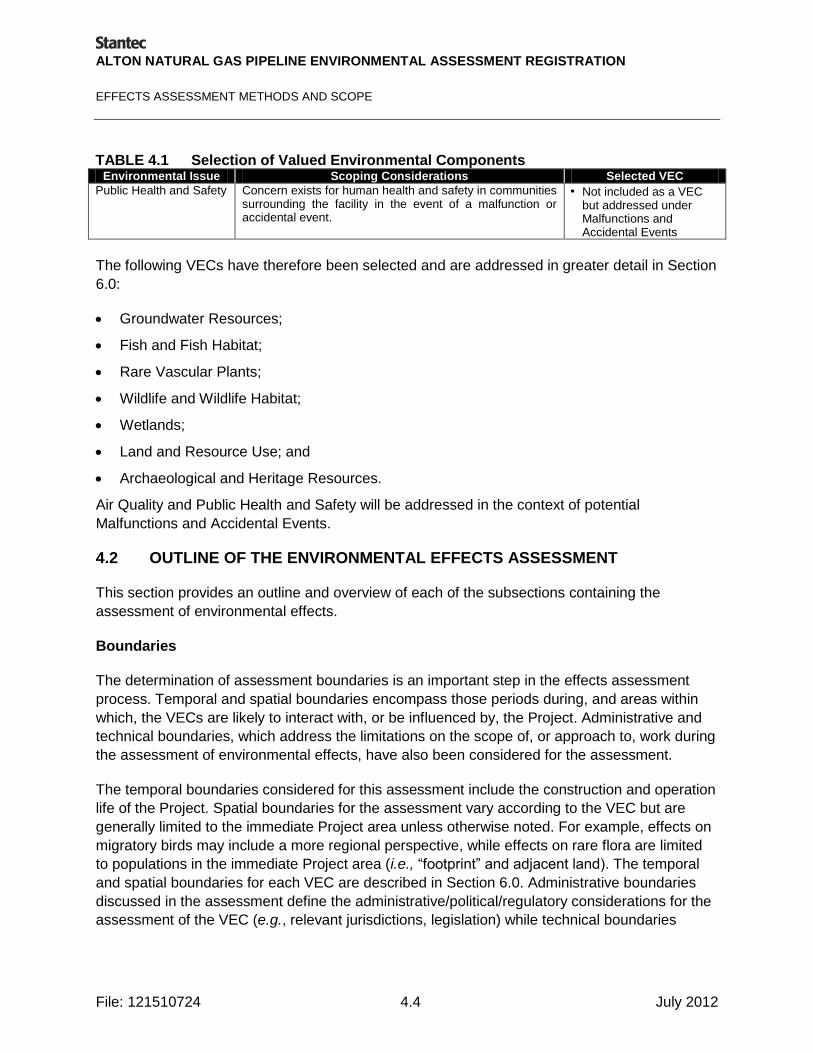
ALTON NATURAL GAS PIPELINE ENVIRONMENTAL ASSESSMENT REGISTRATION
EFFECTS ASSESSMENT METHODS AND SCOPE
File: 121510724 4.4 July 2012
TABLE 4.1 Selection of Valued Environmental Components Environmental Issue Scoping Considerations Selected VEC
Public Health and Safety Concern exists for human health and safety in communities surrounding the facility in the event of a malfunction or accidental event.
• Not included as a VEC but addressed under Malfunctions and Accidental Events
The following VECs have therefore been selected and are addressed in greater detail in Section
6.0:
Groundwater Resources;
Fish and Fish Habitat;
Rare Vascular Plants;
Wildlife and Wildlife Habitat;
Wetlands;
Land and Resource Use; and
Archaeological and Heritage Resources.
Air Quality and Public Health and Safety will be addressed in the context of potential
Malfunctions and Accidental Events.
4.2 OUTLINE OF THE ENVIRONMENTAL EFFECTS ASSESSMENT
This section provides an outline and overview of each of the subsections containing the
assessment of environmental effects.
Boundaries
The determination of assessment boundaries is an important step in the effects assessment
process. Temporal and spatial boundaries encompass those periods during, and areas within
which, the VECs are likely to interact with, or be influenced by, the Project. Administrative and
technical boundaries, which address the limitations on the scope of, or approach to, work during
the assessment of environmental effects, have also been considered for the assessment.
The temporal boundaries considered for this assessment include the construction and operation
life of the Project. Spatial boundaries for the assessment vary according to the VEC but are
generally limited to the immediate Project area unless otherwise noted. For example, effects on
migratory birds may include a more regional perspective, while effects on rare flora are limited
to populations in the immediate Project area (i.e., ―footprint‖ and adjacent land). The temporal
and spatial boundaries for each VEC are described in Section 6.0. Administrative boundaries
discussed in the assessment define the administrative/political/regulatory considerations for the
assessment of the VEC (e.g., relevant jurisdictions, legislation) while technical boundaries

ALTON NATURAL GAS PIPELINE ENVIRONMENTAL ASSESSMENT REGISTRATION
EFFECTS ASSESSMENT METHODS AND SCOPE
File: 121510724 4.5 July 2012
define technical factors which may have imposed constraints on the assessment (e.g.,
availability of data, time).
Description of Existing Conditions
Existing conditions (i.e., pre-Project) are described for each VEC. The description is restricted to
a discussion of the status and characteristics of the VEC within the boundaries established for
the assessment. In order to improve the focus of the assessment, the description focuses on
aspects that are relevant to potential Project interactions.
Residual Environmental Effects Evaluation Criteria
For this assessment, significance is specifically defined and determined for each environmental
component and is defined based on information obtained in issues scoping, available
information on the status and characteristics of the environmental component, existing
standards or regulations, and professional judgment.
Potential Interactions, Issues and Concerns
Potential Project interactions with VECs are described in the assessment through a description
of the degree to which VECs are exposed to each Project activity. Where appropriate, the
assessment includes a summary of major concerns or hypotheses of relevance regarding the
effect of each Project activity on the VECs being considered. Where existing knowledge
indicates that an interaction is not likely to result in an effect, certain issues may not warrant
further analysis.
Analysis, Mitigation and Residual Environmental Effects Prediction
The assessment focuses on the evaluation of potential interactions between the VECs and the
various Project activities outlined in the Project description. Residual environmental effects are
those that remain after mitigation and control measures are applied.
The effects evaluation for each VEC is conducted by Project phase (i.e., construction and
operation) and for malfunctions and accidental events. For each phase, the Study Team selects
those Project activities that may result in a positive or adverse effect. To determine if there are
adverse effects, the Study Team considers a number of factors including:
magnitude;
geographic extent;
duration;
frequency;
reversibility; and
context.

ALTON NATURAL GAS PIPELINE ENVIRONMENTAL ASSESSMENT REGISTRATION
EFFECTS ASSESSMENT METHODS AND SCOPE
File: 121510724 4.6 July 2012
During the evaluation, the definition of significance is applied to any residual adverse
environmental effects that have been identified. As a result, residual adverse environmental
effects are predicted to be either significant or not-significant.
Follow-up and Monitoring
Recommendations for follow-up studies or monitoring activities are included, where appropriate.
Summary of Residual Environmental Effects Assessment
Finally, the residual environmental effects on each VEC by Project phase are summarized.
4.3 SPECIES AT RISK DEFINITIONS
Endangered and threatened plant species that are protected federally under the Species at Risk
Act (SARA) are listed in Schedule 1 of the Act. As defined in SARA, "wildlife species" means a
species, subspecies, variety or geographically or genetically distinct population of animal, plant
or other organism, other than a bacterium or virus, that is wild by nature and (a) is native to
Canada; or (b) has extended its range into Canada without human intervention and has been
present in Canada for at least 50 years. The purpose of this Act is to protect wildlife Species at
Risk and their critical habitat. SARA is administered by Environment Canada, Parks Canada
Agency, and DFO. Those species listed as ―Endangered‖ or ―Threatened‖ in Schedule 2 or 3 of
SARA may also be considered as Species at Risk, pending regulatory consultation.
Designations to SARA are primarily based on rankings and reports provided by the Committee
on the Status of Endangered Wildlife in Canada (COSEWIC). While not a regulatory designation,
the importance of COSEWIC-listed species that are not currently listed under SARA are noted
throughout the document for added context.
Certain species are also protected under the Nova Scotia Endangered Species Act (NSESA).
Species identified as seriously at risk of extinction in the province are identified by a provincial
status assessment process through the Nova Scotia Endangered Species Working Group.
Once identified, they are protected under the NSESA. The conservation and recovery of species
assessed and legally listed under the NSESA is coordinated by the Wildlife Division of the Nova
Scotia Department of Natural Resources (NSDNR).
There is also a provincial General Status assessment process that serves as a first alert tool for
identifying species in the province that are potentially at risk. Under this process, the
populations of species which are native to the province are classified to be either ―At Risk‖, ―May
be at Risk‖, ―Sensitive‖ to human activities or natural events, ―Secure‖, or ―Undetermined‖
should there be insufficient data, information, or knowledge available to assess their status.
Although species listed under this process are not granted legislative protection, the presence of
plants whose populations are considered to be At Risk, May be at Risk, or Sensitive is an issue
of concern for provincial regulators. Also, the Atlantic Canada Conservation Data Center
(ACCDC) provides rarity rankings which may be used to identify species of conservation
concern and these require consideration for the purpose of environmental assessments.

ALTON NATURAL GAS PIPELINE ENVIRONMENTAL ASSESSMENT REGISTRATION
EFFECTS ASSESSMENT METHODS AND SCOPE
File: 121510724 4.7 July 2012
Information used in support of the assessment of wildlife and vegetation includes that obtained
from COSEWIC, SARA, NSDNR, and the ACCDC. Definitions of rarity ranks for each of these
resources are summarized in Appendix B. To simplify the integration of these resources, the
following definitions are used:
Species at Risk: all plants listed in Schedule 1 of SARA as ―Extirpated‖, Endangered‖ or
―Threatened‖; or protected by the NSESA.
Species of Conservation Concern: all plants listed as ―Special Concern‖ in Schedule 1 of SARA; listed in
Schedule 2 or 3 of SARA; considered ―May Be At Risk‖ or ―Sensitive‖ by NSDNR; and / or ranked as ―S1‖
to ―S3‖ by the ACCDC.
Secure Species: all plants considered to have ―Secure‖ populations in the province by NSDNR and
ranked as ―S4‖ to ―S5‖ by the ACCDC, or which do not otherwise meet the criteria for a Species of
Conservation Concern.