Prepared by: Nizar HANI - UNESCO Hani, Master Degree in Agro Marketing (M2) P a g e | 2 ABSTRACT The...
134
MAB YOUNG SCIENTISTS AWARDS Sustainable Territorial Management and Action Plan Shouf Biosphere Reserve - Development Zone with focus on Abandoned Terraces Lebanon Prepared by: Nizar HANI July 2015
-
Upload
vuonghuong -
Category
Documents
-
view
219 -
download
0
Transcript of Prepared by: Nizar HANI - UNESCO Hani, Master Degree in Agro Marketing (M2) P a g e | 2 ABSTRACT The...
MAB YOUNG SCIENTISTS AWARDS
Sustainable Territorial Management and Action Plan
Shouf Biosphere Reserve - Development Zone with focus on
Abandoned Terraces
Lebanon
Prepared by: Nizar HANI
July 2015
Nizar Hani, Master Degree in Agro Marketing (M2) P a g e | 1
ACKNOWLEDGMENT
The Study has been done for my thesis in Master in Agro-Marketing (M2) at the
Lebanese University - Department of Agriculture, with the support UNESCO Youth
Scientists program as well as many individuals for their contribution, comments,
suggestions and sharing their experiences.
Dr. Salwa Tohmé Tawk who directed this study and without her guidance that study
could not reach its final destination.
Marco, Rosa and Pedro, Spanish ecosystem restoration experts, who took my attention to
be more interested in ecological restoration mainly abandoned terraces.
My colleagues in the Shouf Biosphere Reserve especially Kamal Abou Assi who helped
me to prepare the GIS maps for this study and Mounzer Abou Wadi who is the best in
implementing restoration activities in the field and Mr. Faisal Abu-Izzeddine who is the
senior expert and the god father of the Reserve.
Tawfik Abou Alwan and Raed Zaidan who provided all their experience as professional
farmers and heading the agriculture cooperatives in Barouk and Mrusti villages.
Finally, the big thanks to my beloved family Suzan, Roy and Rim for their patient and
staying at home in the weekends and holidays to complete this study.
Nizar Hani, Master Degree in Agro Marketing (M2) P a g e | 2
ABSTRACT
The study aims to assess the restoration of abandoned terraces in the Shouf area by
transforming it into an income generating agriculture activity. The study area is the
western slopes of the Shouf Biosphere Reserve (SBR), which is located in the Shouf
district in Mount Lebanon. Four restoration scenarios are proposed and analyzed to
restore the different types of vacant land in the three zones of the SBR (core area, buffer
and development zone). For each scenario different interventions are proposed and
discussed. For the “abandoned terraces” a cost-benefit analysis and net present value is
conducted for added value crops such as oregano, wild rose, sumac, azarole, jujube,
myrtle. The study includes a marketing strategy and proposes a 5 years action plan.
The results show that more than 600 hectares are able to be restored by using the
restoration scenarios which is suggested in this study. The restoration cost of one
irrigated hectare is around USD 20.000 and the annual net revenue is a minimum of USD
13,000 and a maximum of USD 26,000 per year when planted intensive oregano and rain
fed native species. Hence the restoration of the total abandoned terraces in the study area
is able to provide an income ranging between USD 7.8 million and 15.6 million per year.
The new integrated management of the abandoned terraces will enhance the socio-
economic and environmental situation of the region and can be applied on local, national
and regional levels.
Nizar Hani, Master Degree in Agro Marketing (M2) P a g e | 3
خالصة
النظم اإليكولوجية في محمية واإلجتماعية لنشاطات إعادة تأهيل هذه الدراسة تقييم الحالة اإلقتصادية
الشوف المحيط الحيوي التي تقع في منطقة الشوف في جبل لبنان وخاصة األراضي الزراعية
أربع نماذج إلعادة تأهيل النظم اإليكولوجية في . المهجورة وتحويلها إلى مصدر دخل ألصحابها
.حمية، منطقة العزل ومنطقة التنمية()قلب الم ية تم مناقشتها وإقتراحهاالطبقات الثالثة المختلفة للمحم
إقتراح زرعها بأنواع ذات قيمة مضافة مثل الزعتر والزعرور تمألراضي الزراعية المهملة ل
إعداد دراسة الجدوى اإلقتصادية والمنافع اإلجتماعية والسماق والعناب والحنبالس وغيرها ومن ثم
طة تنفيذية مع جدول زمني لمدة خمس لها باإلضافة إلى خطة تسويق للمحاصيل وللمنتجات وخ
الف 20دنم( من األراضي المهملة حوالي 10تار الواحد )كتبلغ تكلفة إعادة تأهيل اله. سنوات
الف 26الف دوالر في السنة ويمكن أن تصل إلى 13دوالر أميركي أما العائدات فتبلغ كحد أدنى
هكتار وعائداتها 600االراضي القابلة إلعادة التأهيل تبلغ مساحتها حوالي .دوالر للهكتار الواحد
هذا النموذج الجديد من إعادة تأهيل . ون دوالر أميركيملي 15،6مليون و 7،8بعد أن يتم تأهيلها بين
النظم اإليكولوجية يستطيع أن يحسن الحالة اإلقتصادية واإلجتماعية والبيئية لمنطقة الدراسة ويمكن
.تطبيقه على المستوى المحلي والوطني واإلقليمي
Nizar Hani, Master Degree in Agro Marketing (M2) P a g e | 4
RÉSUMÉ
L'étude vise à évaluer la restauration de terrasses abandonnées dans la région du Chouf en
les transformant en une activité agricole génératrice de revenus. La zone d'étude est le
versant ouest de la biosphère de la réserve du Chouf ( SBR ), située dans la région du
Chouf au Mont Liban. Quatre scénarios de restauration sont proposés et analysés afin de
restaurer les différents types de terrains vacants dans les trois zones de la SBR (zone
centrale, zone tampon et zone de développement). Pour chaque scénario différentes
interventions sont proposées et discutées. Pour les « terrasses abandonnées " une analyse
coûts-bénéfices et la valeur actuelle nette est calculée pour les cultures à valeur ajoutée
comme l'origan, le rosier sauvage, sumac, azerole, le jujube, le myrte. L'étude comprend
une stratégie de marketing et propose un plan d'action de 5 ans. Les résultats montrent
que plus de 600 hectares sont aptes à être restauré en utilisant les scénarios de
restauration suggérés dans cette étude. Le coût de restauration d'un hectare irrigué est
d'environ USD 20.000 et le revenu net annuel est de 13 000 USD au minimum et 26 000
USD maximum par année pour une plantation intensive et pluviale d’origan d’espèces
indigène. La restauration des terrasses abandonnées total dans la zone d'étude est en
mesure de fournir un revenu compris entre 7,8 millions USD et 15,6 millions par an.
La nouvelle gestion intégrée des terrasses abandonnées permettra d'améliorer la situation
socio -économique et environnemental de la région et peut être appliquée aux niveaux
local, national et régional.
Nizar Hani, Master Degree in Agro Marketing (M2) P a g e | 5
TABLE OF CONTENTS
MAB YOUNG SCIENTISTS AWARDS ........................................................................ 1
Acknowledgment ................................................................................................................ 1
Abstract ............................................................................................................................... 2
3 ................................................................................................................................... خالصة
Résumé ................................................................................................................................ 4
Table of Contents ................................................................................................................ 5
Abbreviations and acronyms............................................................................................... 7
List of figures ...................................................................................................................... 8
List of tables ........................................................................................................................ 9
List of photos .................................................................................................................... 10
A. Introduction ............................................................................................................... 11
B. General Background ................................................................................................. 15
B.1. Ecosystem restoration ........................................................................................... 15
B.2. Man and the Biosphere Programme (MAB) ......................................................... 18
B.3. Abandoned terraces: .............................................................................................. 24
C. Shouf Biosphere Reserve background ...................................................................... 27
C.1. Legal status ............................................................................................................ 27
C.2. Site Description: .................................................................................................... 28
C.3. State of the agriculture in Lebanon and the Shouf area ........................................ 46
D. Study area and Methodology .................................................................................... 53
D.1. Description of the study area ................................................................................ 53
D.2. Agriculture challenges in the study area ............................................................... 59
D.3. Description of the four ecosystem restoration scenarios: ..................................... 59
D.4. Problematic ........................................................................................................... 78
D.5. Main objective....................................................................................................... 78
D.6. Methodology: ........................................................................................................ 78
E. Situation Analysis ..................................................................................................... 81
E.1. Actors and Stakeholders ........................................................................................ 81
E.2. Strengths and weaknesses of the agriculture sector: ............................................. 83
E.3. Options proposed for the restoration of the abandoned terraces: .......................... 86
F. Cost benefit analysis for re-planting in the abandoned terraces ............................... 92
Nizar Hani, Master Degree in Agro Marketing (M2) P a g e | 6
F.1. Products ................................................................................................................. 92
F.2. Cost analysis .......................................................................................................... 94
F.3. Net Present Value Criterion for option 2: ............................................................ 100
G. Some marketing Activities : Branding, Packaging and Marketing plan ................. 105
G.1. Initiation of a brand name and packaging for the products ................................. 105
G.2. Development of some Marketing activities for the products and goods........... 109
H. Proposal for a 5 years action plan ........................................................................... 113
I. Limitations .............................................................................................................. 115
J. Conclusion .............................................................................................................. 116
K. Recommendations ................................................................................................... 117
L. References: .............................................................................................................. 119
M. Annexes................................................................................................................ 123
Nizar Hani, Master Degree in Agro Marketing (M2) P a g e | 7
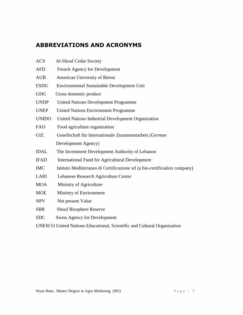
ABBREVIATIONS AND ACRONYMS
ACS Al-Shouf Cedar Society
AFD French Agency for Development
AUB American University of Beirut
ESDU Environmental Sustainable Development Unit
GDG Gross domestic product
UNDP United Nations Development Programme
UNEP United Nations Environment Programme
UNIDO United Nations Industrial Development Organization
FAO Food agriculture organization
GIZ Gesellschaft für Internationale Zusammenarbeit (German
Development Agency)
IDAL The Investment Development Authority of Lebanon
IFAD International Fund for Agricultural Development
IMC Istituto Mediterraneo di Certificazione srl (a bio-certification company)
LARI Lebanese Research Agriculture Center
MOA Ministry of Agriculture
MOE Ministry of Environment
NPV Net present Value
SBR Shouf Biosphere Reserve
SDC Swiss Agency for Development
UNESCO United Nations Educational, Scientific and Cultural Organization
Nizar Hani, Master Degree in Agro Marketing (M2) P a g e | 8
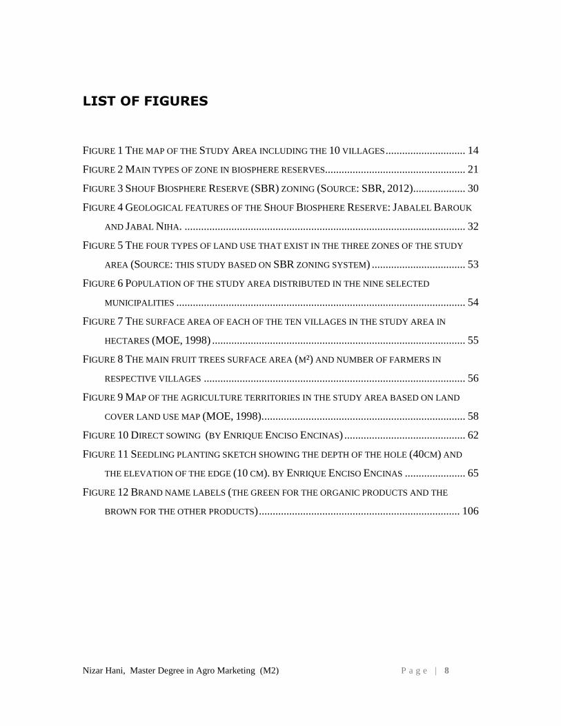
LIST OF FIGURES
FIGURE 1 THE MAP OF THE STUDY AREA INCLUDING THE 10 VILLAGES ............................. 14
FIGURE 2 MAIN TYPES OF ZONE IN BIOSPHERE RESERVES................................................... 21
FIGURE 3 SHOUF BIOSPHERE RESERVE (SBR) ZONING (SOURCE: SBR, 2012) ................... 30
FIGURE 4 GEOLOGICAL FEATURES OF THE SHOUF BIOSPHERE RESERVE: JABALEL BAROUK
AND JABAL NIHA. ...................................................................................................... 32
FIGURE 5 THE FOUR TYPES OF LAND USE THAT EXIST IN THE THREE ZONES OF THE STUDY
AREA (SOURCE: THIS STUDY BASED ON SBR ZONING SYSTEM) .................................. 53
FIGURE 6 POPULATION OF THE STUDY AREA DISTRIBUTED IN THE NINE SELECTED
MUNICIPALITIES ......................................................................................................... 54
FIGURE 7 THE SURFACE AREA OF EACH OF THE TEN VILLAGES IN THE STUDY AREA IN
HECTARES (MOE, 1998) ............................................................................................ 55
FIGURE 8 THE MAIN FRUIT TREES SURFACE AREA (M²) AND NUMBER OF FARMERS IN
RESPECTIVE VILLAGES ............................................................................................... 56
FIGURE 9 MAP OF THE AGRICULTURE TERRITORIES IN THE STUDY AREA BASED ON LAND
COVER LAND USE MAP (MOE, 1998). ......................................................................... 58
FIGURE 10 DIRECT SOWING (BY ENRIQUE ENCISO ENCINAS) ............................................ 62
FIGURE 11 SEEDLING PLANTING SKETCH SHOWING THE DEPTH OF THE HOLE (40CM) AND
THE ELEVATION OF THE EDGE (10 CM). BY ENRIQUE ENCISO ENCINAS ...................... 65
FIGURE 12 BRAND NAME LABELS (THE GREEN FOR THE ORGANIC PRODUCTS AND THE
BROWN FOR THE OTHER PRODUCTS) ......................................................................... 106
Nizar Hani, Master Degree in Agro Marketing (M2) P a g e | 9
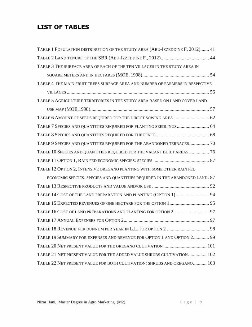
LIST OF TABLES
TABLE 1 POPULATION DISTRIBUTION OF THE STUDY AREA (ABU-IZZEDDINE F, 2012)....... 41
TABLE 2 LAND TENURE OF THE SBR (ABU-IZZEDDINE F., 2012) ....................................... 44
TABLE 3 THE SURFACE AREA OF EACH OF THE TEN VILLAGES IN THE STUDY AREA IN
SQUARE METERS AND IN HECTARES (MOE, 1998)...................................................... 54
TABLE 4 THE MAIN FRUIT TREES SURFACE AREA AND NUMBER OF FARMERS IN RESPECTIVE
VILLAGES ................................................................................................................... 56
TABLE 5 AGRICULTURE TERRITORIES IN THE STUDY AREA BASED ON LAND COVER LAND
USE MAP (MOE,1998)................................................................................................ 57
TABLE 6 AMOUNT OF SEEDS REQUIRED FOR THE DIRECT SOWING AREA ............................. 62
TABLE 7 SPECIES AND QUANTITIES REQUIRED FOR PLANTING SEEDLINGS .......................... 64
TABLE 8 SPECIES AND QUANTITIES REQUIRED FOR THE FENCE ........................................... 68
TABLE 9 SPECIES AND QUANTITIES REQUIRED FOR THE ABANDONED TERRACES ................ 70
TABLE 10 SPECIES AND QUANTITIES REQUIRED FOR THE VACANT BUILT AREAS ................ 76
TABLE 11 OPTION 1, RAIN FED ECONOMIC SPECIES: SPECIES ............................................. 87
TABLE 12 OPTION 2, INTENSIVE OREGANO PLANTING WITH SOME OTHER RAIN FED
ECONOMIC SPECIES: SPECIES AND QUANTITIES REQUIRED IN THE ABANDONED LAND . 87
TABLE 13 RESPECTIVE PRODUCTS AND VALUE AND/OR USE .............................................. 92
TABLE 14 COST OF THE LAND PREPARATION AND PLANTING (OPTION 1) ........................... 94
TABLE 15 EXPECTED REVENUES OF ONE HECTARE FOR THE OPTION 1 ................................ 95
TABLE 16 COST OF LAND PREPARATIONS AND PLANTING FOR OPTION 2 ............................ 97
TABLE 17 ANNUAL EXPENSES FOR OPTION 2 ..................................................................... 97
TABLE 18 REVENUE PER DUNNUM PER YEAR IN L.L. FOR OPTION 2 .................................. 98
TABLE 19 SUMMARY FOR EXPENSES AND REVENUE FOR OPTION 1 AND OPTION 2 ............. 99
TABLE 20 NET PRESENT VALUE FOR THE OREGANO CULTIVATION ................................... 101
TABLE 21 NET PRESENT VALUE FOR THE ADDED VALUE SHRUBS CULTIVATION ............... 102
TABLE 22 NET PRESENT VALUE FOR BOTH CULTIVATION: SHRUBS AND OREGANO ........... 103
Nizar Hani, Master Degree in Agro Marketing (M2) P a g e | 1 0
LIST OF PHOTOS
PHOTO 1 THE WESTERN MOUNT LEBANON RIDGE COVERED BY CEDAR FOREST (BY ALAA
MONZER) ................................................................................................................... 34
PHOTO 2 WILD ROSE IN AIN ZHALTA CEDAR FOREST (BY KAMIL EL RAESS) .................... 36
PHOTO 3 ROCK HYRAX IN NIHA FORTRESS (BY ALAA MONZER) ....................................... 38
PHOTO 4 A MIGRATORY BIRD IN THE RESERVE (BY ALAA MONZER) ................................. 38
PHOTO 5 FAKHER EDDINE /NIHA FORTRESS (BY NIZAR HANI) ........................................... 39
PHOTO 6 LAND USE GENERAL VIEW IN MRUSTI VILLAGE (BY EDDY CHOUERI) ................. 43
PHOTO 7 AN OAK SEEDLING (BY NIZAR HANI) .................................................................. 60
PHOTO 8 FIVE YEARS OLD CEDAR SEEDLING (BY NIZAR HANI ) ......................................... 63
PHOTO 9 A WORKER INSTALLING A FENCE FOR THE FENCED PLOTS IN GRAZING AREAS IN
FRAIDISS VILLAGE (BY MOUNZER ABOU WADI) ........................................................ 66
PHOTO 10 OREGANO PLANTS IRRIGATED WITH DRIP IRRIGATION SYSTEM (BY NIZAR HANI)
................................................................................................................................... 72
PHOTO 11 THINNING OF DALBOUN OAK FOREST (BY MOUNZER BUWADI) ........................ 73
PHOTO 12 A HILL LAKE IN BAROUK VILLAGE (BY EDDY CHOUEIRI) ................................. 84
PHOTO 13 ABANDONED TERRACES IN BAADARAN VILLAGE (BY NIZAR HANI) .................. 86
PHOTO 14 ABANDONED TERRACES IN KHRAIBEH VILLAGE (BY NIZAR HANI) .................... 90
PHOTO 15 ABANDONED TERRACES IN MRUSTI VILLAGE (BY EDDY CHOUIRI) .................... 90
PHOTO 16 FOG CATCHER IN A RURAL AREA IN CHILE (BY FOGQUEST) .............................. 91
PHOTO 17 LABELING OF THE SHOUF BIOSPHERE RESERVE (BY ALAA MONZER) ............. 105
PHOTO 18 WOODEN BOX FOR RURAL PRODUCT ................................................................ 107
PHOTO 19 BETTER PACKAGING IN USA (TAKEN IN NATURAL FOOD COOP IN VERMONT –
USA (BY NIZAR HANI) ........................................................................................... 108
PHOTO 20 PRACTICAL CUPBOARD MIXING THE FRESH GOODS WITH PROCESSING FOOD... 108
PHOTO 21 FARMER MARKET (SOUK) CONCEPT DESIGN (BY NIZAR HANI) ....................... 110
PHOTO 22 MIDDLEBURY NATURAL FOOD COOP (BY NIZAR HANI) .................................. 111
Nizar Hani, Master Degree in Agro Marketing (M2) P a g e | 1 1
A. INTRODUCTION
The Shouf is located in the governorate of Mount Lebanon and comprises more than 80
villages and is the third most populous Caza of Mount Lebanon and has 11842 farmers
(Loca Liban, 2013)1 .
The Al-Shouf Cedar Nature Reserve is established in 1996 and in July 2005, UNESCO
declared the Al-Shouf Cedar Nature Reserve a “Biosphere Reserve” called the Shouf
Biosphere Reserve (SBR) with an area of approximately 50,000 hectare - or 5% of the
total area of Lebanon.
The SBR and the municipalities of the region are at the forefront of the movement to
improve the income generating capacity of the area without causing irreversible harm to
its natural resources.
The practice of ecological restoration is many decades old, at least in its more applied
forms, such as erosion control, reforestation, and habitat and range improvement.
However, it has only been in the last 15 years that the science of restoration ecology has
become a strong academic field attracting basic research and being published in indexed
peer-reviewed journals. Associated with this growth has been an increasing desire to
define a scientific identity for restoration ecology and its relationship to ecological
restoration.
Ecological restoration is an important management approach that can, if successful,
contribute to broad societal objectives for sustaining a healthy planet and delivering
essential benefits to people (Petersen, D.A. 2005)2.
The reasons behind implementing restoration projects vary and may include, for example,
recovery of individual species, the strengthening of landscape or seascape-scale
1 Loca Liban website, 2013. www.localiban.org
2 Petersen, D.A. 2005. The ecology of restoration: historical links, emerging issues and unexplored realms, page 662.
Nizar Hani, Master Degree in Agro Marketing (M2) P a g e | 1 2
ecosystem function or connectivity, improvement of visitor experience opportunities, or
the re-establishment or enhancement of various ecosystem services (IUCN, 2012)3.
The ecosystem4 in the Shouf Biosphere Reserve, buffer and development zones is
susceptible for degradation on two levels: the ecological and the physical levels. The
main degradation is at the level of the abandoned terraces which is causing environmental
and economic negative impacts. The major impact is the exposure of the uncultivated
bare land to erosion and the economic impact is the loss of agriculture lucrative
production.
Agricultural land abandonment is a complex phenomenon involving both economic and
social parameters. That the majority of abandoned lands are found in the mountainous
areas is attributable to their marginality, caused by reduced soil fertility, remoteness from
settlements, sleep slopes, high farm fragmentation, high labor requirements, making their
exploitation unprofitable. Another problem is the migration of the young people from
rural to urban areas or their unwilling to take up farming (Tsoumas and Tasioulas 19865,
McDonald et all, 20006).
The main objective of the present study is the socio-economic assessment of the
ecosystem restoration with a focus on abandoned terraces by rehabilitating and
transforming it into an income generating agriculture activity.
Restoration in and around protected areas contributes to many societal goals and
objectives associated with biodiversity conservation and human well-being.
3 IUCN, 2012. Ecological Restoration for Protected Areas, Principles, Guidelines and Best Practices.
4 An ecosystem is a complex relationship among the living resources, habitats and residents of the area. It
includes plants, trees, animals, fish, birds, micro-organisms, water, soil and people. 5 Tsoumas, A., and D. Tasioulas. 1986. Ownership status and use of agricultural land in Greece.
Agricultural Bank of Greece, Athens 6 McDonald, D., J.R. Grabtree, G. Wiesinger, T.Dax, N. Stamu, P. Fleury and A Gibon, 2000. Agricultural
abandoned in mountain areas of Europe: Environmental consequences and policy response. Journal of
environmental management 59: 47-69
Nizar Hani, Master Degree in Agro Marketing (M2) P a g e | 1 3
The present study is based on existing restoration scenarios for restoring land in the three
zones of the study area in the SBR (core area, buffer and development zones). For each
scenario different interventions are proposed and discussed. For the “abandoned terraces”
a cost-benefit analysis and net present value is conducted for added value crops including
a marketing strategy and a 5 years action plan.
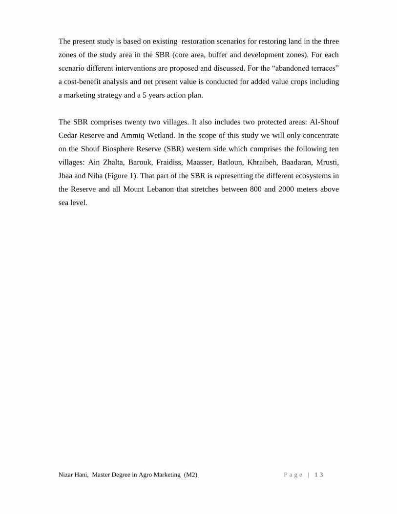
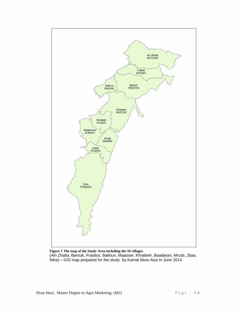
The SBR comprises twenty two villages. It also includes two protected areas: Al-Shouf
Cedar Reserve and Ammiq Wetland. In the scope of this study we will only concentrate
on the Shouf Biosphere Reserve (SBR) western side which comprises the following ten
villages: Ain Zhalta, Barouk, Fraidiss, Maasser, Batloun, Khraibeh, Baadaran, Mrusti,
Jbaa and Niha (Figure 1). That part of the SBR is representing the different ecosystems in
the Reserve and all Mount Lebanon that stretches between 800 and 2000 meters above
sea level.
Nizar Hani, Master Degree in Agro Marketing (M2) P a g e | 1 4
Figure 1 The map of the Study Area including the 10 villages
(Ain Zhalta, Barouk, Fraidiss, Batloun, Maasser, Khraibeh, Baadaran, Mrusti, Jbaa, Niha) – GIS map prepared for the study by Kamal Abou Assi in June 2014
Nizar Hani, Master Degree in Agro Marketing (M2) P a g e | 1 5
B. GENERAL BACKGROUND
B.1. ECOSYSTEM RESTORATION
An ecosystem is a complex relationship among the living resources, habitats and
residents of the area. It includes plants, trees, animals, fish, birds, micro-organisms,
water, soil and people.
E. O. Wilson, a biologist states that: "Here is the means to end the great extinction spasm.
The next century will, I believe, be the era of restoration in ecology" (Wilson E.O.,
1998)7
The Society for Ecological Restoration (SER) in 2004 defined the Ecosystem / Ecological
restoration is the process of assisting the recovery of an ecosystem that has been
degraded, damaged, or destroyed (IUCN, 2012)8.
There are many reasons to restore ecosystems (Harris et al. 20069, Macdonald, 2002
10):
Restoring natural capital such as drinkable water or wildlife populations.
Mitigating climate change (e.g. through carbon sequestration)
Helping threatened or endangered species
Recovery of individual species
Aesthetic reasons
Moral reasons: we have degraded, and in some cases destroyed, many ecosystems so
it falls on us to ‘fix’ them
Strengthening of landscape or seascape-scale ecosystem function or connectivity
Improvement of visitor experience opportunities, or the re-establishment or
enhancement of various ecosystem services
7 Wilson, E. O., 1988. Biodiversity. Washington DC: National Academy. ISBN 0-309-03739-5
8 IUCN, 2012. Ecological Restoration for Protected Areas, Principles, Guidelines and Best Practices
9 Harris, J.A., Hobbs, R.J, Higgs, E. and Aronson, J. (2006) Ecological restoration and global climate
change. Restoration Ecology 14(2) 170 - 176 10
Macdonald, 2002. The ecological context: a species population perspective. Cambridge University Press,
Cambridge
Nizar Hani, Master Degree in Agro Marketing (M2) P a g e | 1 6
Restoration in and around protected areas contributes to many societal goals and
objectives associated with biodiversity conservation and human well-being (IUCN,
2012)11
.
Restoration ecology is the field of science associated with ecological restoration.
The practice of ecological restoration is many decades old, at least in its more applied
forms, such as erosion control, reforestation, and habitat and range improvement.
However, it has only been in the last 15 years that the science of restoration ecology has
become a strong academic field attracting basic research and being published in indexed
peer-reviewed journals. Associated with this growth has been an increasing desire to
define a scientific identity for restoration ecology and its relationship to ecological
restoration.
Ecological restoration is an important management approach that can, if successful,
contribute to broad societal objectives for sustaining a healthy planet and delivering
essential benefits to people (Petersen, D.A. 2005)12
. It offers hope of repairing ecological
damage, renewing economic opportunities, rejuvenating traditional cultural practices, and
enhancing ecological and social resilience to environmental change.
The nine attributes listed below provide a basis for determining when restoration has
been accomplished. The full expression of all of these attributes is not essential to
demonstrate restoration. Instead, it is only necessary for these attributes to demonstrate an
appropriate trajectory of ecosystem development towards the intended goals or reference.
Some attributes are readily measured. Others must be assessed indirectly, including most
ecosystem functions, which cannot be ascertained without research efforts that exceed the
capabilities and budgets of most restoration projects.(SER, 2004)13
11
IUCN, 2012. Ecological Restoration for Protected Areas, Principles, Guidelines and Best Practices 12
Pestersen, D.A. 2005. The ecology of restoration: historical links, emerging issues and unexplored
realms, page 672. 13
Society for Ecological Restoration International Science & Policy Working Group, 2004. The SER
International Primer on Ecological Restoration. www.ser.org & Tucson: Society for Ecological Restoration
International.
Nizar Hani, Master Degree in Agro Marketing (M2) P a g e | 1 7
1. The restored ecosystem contains a characteristic assemblage of the species that occur
in the reference ecosystem and that provide appropriate community structure.
2. The restored ecosystem consists of indigenous species to the greatest practicable
extent.
3. All functional groups necessary for the continued development and/or stability of the
restored ecosystem are represented or, if they are not, the missing groups have the
potential to colonize by natural means.
4. The physical environment of the restored ecosystem is capable of sustaining
reproducing populations of the species necessary for its continued stability or
development along the desired trajectory.
5. The restored ecosystem apparently functions normally for its ecological stage of
development, and signs of dysfunction are absent.
6. The restored ecosystem is suitably integrated into a larger ecological matrix or
landscape, with which it interacts through abiotic and biotic flows and exchanges.
7. Potential threats to the health and integrity of the restored ecosystem from the
surrounding landscape have been eliminated or reduced as much as possible.
8. The restored ecosystem is sufficiently resilient to endure the normal periodic stress
events in the local environment that serve to maintain the integrity of the ecosystem.
9. The restored ecosystem is self-sustaining to the same degree as its reference
ecosystem, and has the potential to persist indefinitely under existing environmental
conditions.
Finally, the rehabilitation of the Loess Plateau in China witnessed on the land change
from a fundamentally degraded system into a system that is stimulating the growth of
vast amounts of biomass, accumulating organic matter in the soil, protecting and creating
new habitat for biodiversity and naturally in filtrating and retaining rainfall. The results
have exceeded even the designer’s expectations and have shown that it is possible to
rehabilitate large scale damaged ecosystems. By bringing scientists, technicians and
managers into the local communities the Chinese essentially helped transition poor, often
Nizar Hani, Master Degree in Agro Marketing (M2) P a g e | 1 8
illiterate subsistence agriculturalists to a new paradigm within one generation (John D
Liu, 2011)14
.
B.2. MAN AND THE BIOSPHERE PROGRAMME (MAB)
According to UNESCO website the MAB launched in 1971, UNESCO’s Man and the
Biosphere Programme (MAB) is an Intergovernmental Scientific Programme that aims to
establish a scientific basis for the improvement of relationships between people and their
environments. It proposes interdisciplinary research, demonstration and training in
natural resources management.
The Statutory Framework of the World Network of Biosphere Reserves defined the
Biosphere Reserves as “areas of terrestrial and Coastal/marine ecosystems or a
combination thereof, which are internationally recognized within the framework of
UNESCO’s programme on Man and the Biosphere (MAB)”.
Its World Network of Biosphere Reserves currently counts 631 biosphere reserves in
119 countries all over the world
The MAB Programme develops the basis within the natural and social sciences for the
rational and sustainable use and conservation of the resources of the biosphere and for the
improvement of the overall relationship between people and their environment. It predicts
the consequences of today’s actions on tomorrow’s world and thereby increases people’s
ability to efficiently manage natural resources for the well-being of both human
populations and the environment. (UNESCO, 1996)15
By focusing on sites internationally recognized within the World Network of Biosphere
Reserves, the MAB Programme strives to:
- identify and assess the changes in the biosphere resulting from human and natural
activities and the effects of these changes on humans and the environment, in
particular in the context of climate change
14
John D Liu, 2011. The Changing Nature of Human Security, Finding sustainability in Ecosystem
restoration, page 21. 15
UNESCO, 1996. Biosphere reserves: the Seville Strategy and the Framework Statutory of the World
Network. UNESCO, Paris. Page 5
Nizar Hani, Master Degree in Agro Marketing (M2) P a g e | 1 9
- study and compare the dynamic interrelationships between natural/near-natural
ecosystems and socio-economic processes, in particular in the context of
accelerated loss of biological and cultural diversity with unexpected consequences
that impact the ability of ecosystems to continue to provide services critical for
human well-being;
- ensure basic human welfare and a livable environment in the context of rapid
urbanization and energy consumption as drivers of environmental change;
- promote the exchange and transfer of knowledge on environmental problems and
solutions, and to foster environmental education for sustainable development.
B.2.1: MAB Governing Bodies
The main MAB governing body, the International Coordinating Council of the Man and
the Biosphere (MAB) Programme, usually referred to as the MAB Council or ICC,
consists of 34 Member States elected by UNESCO's biennial General Conference.
B.2.2: Biosphere Reserves – Learning Sites for Sustainable Development
Biosphere reserves are sites established by countries and recognized under
UNESCO's Man and the Biosphere (MAB) Programme to promote sustainable
development based on local community efforts and sound science.
As places that seek to reconcile conservation of biological and cultural diversity and
economic and social development through partnerships between people and nature, they
are ideal to test and demonstrate innovative approaches to sustainable development from
local to international scales.
Biosphere reserves are thus globally considered as:
sites of excellence where new and optimal practices to manage nature and human
activities are tested and demonstrated;
tools to help countries implement the results of the World Summit on Sustainable
Development and, in particular, the Convention on Biological Diversity and its
Ecosystem Approach;
learning sites for the UN Decade on Education for Sustainable Development.
Nizar Hani, Master Degree in Agro Marketing (M2) P a g e | 2 0
After their designation, biosphere reserves remain under national sovereign jurisdiction,
yet they share their experience and ideas nationally, regionally and internationally within
the World Network of Biosphere Reserves (WNBR) (Ishwaran et al, 2008)16
.
B.2.3: Main Characteristics of Biosphere Reserves
The main characteristics of biosphere reserves are (Barisse M., 1986)17:
Achieving the three interconnected functions: conservation, development and logistic
support;
Outpacing traditional confined conservation zones, through appropriate zoning
schemes combining core protected areas with zones where sustainable development is
fostered by local dwellers and enterprises with often highly innovative and participative
governance systems;
Focusing on a multi-stakeholder approach with particular emphasis on the involvement of
local communities in management;
Fostering dialogue for conflict resolution of natural resource use;
Integrating cultural and biological diversity, especially the role of traditional knowledge
in ecosystem management;
Demonstrating sound sustainable development practices and policies based on research
and monitoring;
Acting as sites of excellence for education and training;
Participating in the World Network.
16
Ishwaran, N., Persic, A. and Tri, N.H. 2008. ‘Concept and practice: the case of UNESCO biosphere
reserves’, Int. J. Environment and Sustainable Development.
17
Batisse, M., 1986. ‘Developing and focusing the biosphere reserve concept’, Nature and resources.
Nizar Hani, Master Degree in Agro Marketing (M2) P a g e | 2 1
B.2.4: Zoning
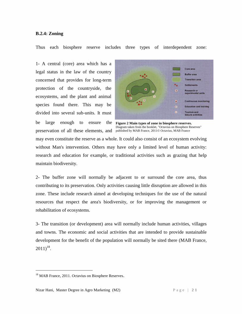
Thus each biosphere reserve includes three types of interdependent zone:
1- A central (core) area which has a
legal status in the law of the country
concerned that provides for long-term
protection of the countryside, the
ecosystems, and the plant and animal
species found there. This may be
divided into several sub-units. It must
be large enough to ensure the
preservation of all these elements, and
may even constitute the reserve as a whole. It could also consist of an ecosystem evolving
without Man's intervention. Others may have only a limited level of human activity:
research and education for example, or traditional activities such as grazing that help
maintain biodiversity.
2- The buffer zone will normally be adjacent to or surround the core area, thus
contributing to its preservation. Only activities causing little disruption are allowed in this
zone. These include research aimed at developing techniques for the use of the natural
resources that respect the area's biodiversity, or for improving the management or
rehabilitation of ecosystems.
3- The transition (or development) area will normally include human activities, villages
and towns. The economic and social activities that are intended to provide sustainable
development for the benefit of the population will normally be sited there (MAB France,
2011)18
.
18
MAB France, 2011. Octavius on Biosphere Reserves.
Figure 2 Main types of zone in biosphere reserves. Diagram taken from the booklet, "Octavius on Biosphere Reserves"
published by MAB France, 2011© Octavius, MAB France
Nizar Hani, Master Degree in Agro Marketing (M2) P a g e | 2 2
B.2.5: Provision of Ecosystem Services
The Millennium Ecosystem Assessment (MA) has articulated and described ecosystem
services in a manner that has gained widespread acceptance among public and private
sector and civil society organizations. The new MA typology recognizes four distinct
categories of services: supporting (nutrient cycling, soil formation and primary
production); provisioning (food, fresh water, wood and fibre and fuel); regulating
(climate, flood and disease regulation and water purification) and cultural (aesthetic,
spiritual, educational and recreational).
Ecosystem services could be a useful conceptual framework to superimpose on the
multiple functions of biosphere reserves ranging from protection to production in
land/seascapes. The essence of biosphere reserves as sustainable development sites could
be seen as the effort to design and develop place-specific mixes of supporting,
provisioning, regulating and cultural
Ecosystem services that enable the environmental, economic and social well-being of
resident and stakeholder communities. For example, the various zones of biosphere
reserves can serve as places to attract new investments into hitherto neglected services
(climate regulation, water purification, biodiversity conservation) and improve
environmental and social performance of provisioning (agriculture, forestry, fisheries)
and cultural (tourism) services that may have been the principal recipients of investments
to-date. Active and continuing consultations between the scientific and research
communities, policy and decision makers, resource managers and resident populations in
a biosphere reserve are critical in finding the optimal mix of eco- system services that
would illustrate the role of biosphere reserves as models for land/seascape level
sustainable development at the national, regional and global levels.
Nizar Hani, Master Degree in Agro Marketing (M2) P a g e | 2 3
B.2.6: Urbanization As a Principal Driver for Ecosystem-wide Pressure
Urbanization is a global multidimensional process that manifests itself through rapidly
changing and spatially shifting population densities, in particular migration from rural to
urban zones, land cover and resource use regimes and a diversity of associated cultural
practices. (UNESCO, 2010)19
Half of the world’s population today lives in urban landscapes, a proportion projected to
increase to 66–67% over the next 50 years. Most of this growth will occur in countries
that constitute the less industrialized and emerging market economies of the world. It is
estimated that by 2030 more than two billion people will be living in urban slums with
limited access to basic services, facing extreme vulnerability to natural disasters. The
rapid increase of large cities and the continuing transformation of urban landscapes
represent great challenges to ensure basic human welfare and a liveable environment.
Urban landscapes represent probably the most complex mosaic of land cover and
multiple uses of any landscape. Urbanization and urban landscapes have recently been
identified by the MA as priority areas where large knowledge gaps exist. Urban
landscapes provide important large-scale experiences of the effects of global
change on ecosystems; significant warming and increased nitrogen deposition are already
evident and they provide extreme, visible and measurable examples of human domination
of ‘natural’ ecosystem processes. However, cities are also perceived as places offering
solutions for humans and the environment as main hubs of knowledge, capital and
innovations.
A number of urban areas are either considering, or have applied, the biosphere reserve
principles within their jurisdictions, with the intention of using the concept as a tool for
planning and managing sustainable urban development.
19
UNESCO, 2010. Madrid Action Plan 2008-2013. Pages 6-7
Nizar Hani, Master Degree in Agro Marketing (M2) P a g e | 2 4
B.3. ABANDONED TERRACES:
Land use change is a complex phenomenon. Houghton (1991)20
recognized seven broad
types of land use change:
1- Conversion of natural ecosystems for permanent croplands
2- Conversion of natural ecosystems for shifting cultivation
3- Conversion of natural ecosystems to pastures
4- Abandonment of croplands
5- Abandonment of pastures
6- Harvest of timber
7- Establishment of tree plantations
In addition, the urbanization is a factor that is growing in importance and likely to lead to
the conversion of both natural and agriculture systems. This factor exists strongly in the
study area of this study.
Land abandonment has been a feature of humanity’s relationship with the world’s
ecosystems for as long as history has been recorded. The past civilizations have
developed agriculture systems that were subsequently abandoned for one reason or
another (Diamond 2005)21
. Generally, the ancient agriculture system was relatively
localized and did not cover large areas of land; it grows to dominate the planet and its
ecosystems (Vitousek at al, 1997)22
. The trends of land use land cover over the last few
decades is one of continuing deforestation and transformation of the earth ‘ecosystems,
there is also a growing trend of abandonment of systems that were previously managed
intensively (Richard et al, 2007)23
.
Old terraces are important ecosystems across the globe. The extent of abandoned land is
increasing rapidly. While we frequently see a focus on deforestation and land
transformation, there is a growing trend for transformed land to be abandoned.
Development of woody vegetation on abandoned terraces has the potential to contribute
20
Houghton, R.A. 1991. Tropical deforestation and atmospheric carbon dioxide. Climate Change 19 21
Diamond, J.M. 2005. Collapse: How societies choose to fail or succeed. Viking Pengium, New York. 22
Vitousek, P.M., H.A. Mooney, J. Lubchenco and J. Melillo, 1997. Human domination of Earth’s
ecosystems. Science 277, page 494 23
Richard J. Hobbs, 2007. Why old fields? Socioeconomic and ecological causes and consequences of land
abandonment. Page 1
Nizar Hani, Master Degree in Agro Marketing (M2) P a g e | 2 5
in a positive way to carbon accounting, providing fast-growing carbon sink. The
socioeconomic consequence of the land abandonment is accompanied by, or leads to,
rural depopulation, loss of traditional industries and reduced income from tourism
(Richard J, 2007)24
. Old terraces are a term used in ecology to describe lands formerly
cultivated or grazed but later abandoned. The dominant flora
includes grasses, heaths and herbaceous plants, with encroaching woody vegetation. It
represents an intermediate stage found in ecological succession in an ecosystem
advancing towards its climax community. The concept of climax communities has been
challenged in recent years
Agriculture land is abandoned when it ceases to generate an income for its owners and
the opportunities for adjustment through changes in farming practices and farm structure
are exhausted (McDonald et al, 2000)25
. Such adjustments is particularly difficult in
marginal lands, where productivity levels are close to the margin beyond which
management and risks are not compensated by the profit obtained with production (Pinto
Correia, 1993)26
. However, land abandonment can also take place by abrupt suspension
of the farming activity, by displacement because of the civil war or by death or retirement
of a farmer without succession (Viki A.Cramer and Richard J.Hobbs, 2007)27
.
The agriculture land abandonment involving both economic and social parameters. That
the majority of abandoned lands are found in the mountainous areas is attributable to their
marginality, caused by reduced soil fertility, remoteness from settlements, steep slopes,
high farm fragmentation, high labor requirements, making their exploitation unprofitable.
24
Richard J. Hobbs, 2007. Why old fields? Socioeconomic and ecological causes and consequences of land
abandonment. Page 1 25
McDonald, D., J.R. Grabtree, G. Wiesinger, T.Dax, N. Stamu, P. Fleury and A Gibon, 2000. Agricultural
abandoned in mountain areas of Europe: Environmental consequences and policy response. Journal of
environmental management 59: 47-69 26
Pinto Correia, T. 1993. Land abandonment: Changes in the land use patterns arounf the Mediterranean
basin. Soils in the Mediterranean regions: use, management, and future trend. 27
Viki A. Cramer and Richard J. Hobbs, 2007. Old fields, Dynamics and Restoration of Abandonment
Farmland.
Nizar Hani, Master Degree in Agro Marketing (M2) P a g e | 2 6
Another problem is the migration of the young people from rural to urban areas or their
unwilling to take up farming (McDonald et all, 2000)28
.
The Abandoned terraces are a common agriculture feature in the study area. A great part
of the study area has been terraced in the past in order to create arable land on steep
slopes for cultivation of cereals, wine and fruit trees. Very few of the terraces are still
cultivated but not with cereals. Few of them are still use for vineyards, olives and fruit
trees. However, even these cultivations are not regularly taken care of, and no repairs for
the old stone walls are done, resulting in their collapse and subsequent washing
downslope of the terraced soil. The main use of these terraces is free grazing by
livestock, and that is a part of the grazing zoning system of the SBR (Abi-Said M.,
2010)29
.
28
McDonald, D., J.R. Grabtree, G. Wiesinger, T.Dax, N. Stamu, P. Fleury and A Gibon, 2000. Agricultural
abandoned in mountain areas of Europe: Environmental consequences and policy response. Journal of
environmental management 59: 47-69
29
Abi Said M., 2010. Grazing Assessment Report, Al-Shouf Cedar Reserve.
Nizar Hani, Master Degree in Agro Marketing (M2) P a g e | 2 7
C. SHOUF BIOSPHERE RESERVE BACKGROUND
C.1. LEGAL STATUS
C.1.1 National and International Standing
Government legislation, Law No. 532 of 24 July 1996 declared “The communal lands of
Ain Dara, Bmohray, Ain Zhalta, Barouk / Fraidiss, Maasser, Khraibeh, Mrusti, Jbaa,
Niha villages, in addition to the government owned lands on the eastern side of Barouk
Mountain” a Nature Reserve. In July 2005, UNESCO declared the Al-Shouf Cedar
Nature Reserve a “Biosphere Reserve” called the Shouf Biosphere Reserve (SBR) with
an area of approximately 50,000 hectare - or 5% of the total area of Lebanon.
The Al-Shouf Cedar Nature Reserve is under the authority of the Lebanese Ministry of
Environment (MOE), which manages it through the Appointed Protected Area
Committee (APAC) that includes among its members the Al-Shouf Cedar Society (ACS),
the mayors of the 10 mentioned villages above, as well as a number of independent
environment experts. APAC liaises with the reserve’s Management Team, which deals
with the Reserve’s day-to-day management and planning.
The SBR includes the:
1- Al-Shouf Cedar Nature Reserve (established in 1996) located in the Shouf mountains
of central Lebanon,
2- Ammiq Wetland, East of the Shouf in the Beqaa Valley. Ammiq is a Ramsar30
site and
one of the last remaining wetlands in the Middle East, and
3- Twenty two (22) villages surrounding the biosphere from the eastern and western sides
of the Barouk and Niha mountains.
In addition to the Ministry of Environment, the following government agencies have
roles and responsibilities that impact on the environment and the Al-Shouf Cedar Nature
Reserve:
The Ministry of Public Works is responsible for the Kefraya-Maasser Shouf road which
passes through the SBR
The Department of Antiquities has jurisdiction over the antiquities and ancient ruins in
the SBR.
30
Ramsar: The Ramsar Convention (formally, the Convention on Wetlands of International Importance, especially as
Waterfowl Habitat) is an international treaty for the conservation and sustainable utilization of wetlands. It is named after the city of Ramsar in Iran, where the Convention was signed in 1971
Nizar Hani, Master Degree in Agro Marketing (M2) P a g e | 2 8
The Ministry of Information and the Maasser Municipality have authority over the T.V.
transmitters in the SBR.
The Barouk Water Office has authority over water rights, especially the Barouk water, in
the Shouf area.
The ministry of agriculture has a role in the agriculture land located mainly in the
development zone of the Reserve.
The SBR needs the cooperation of all government and non-government sectors in order
to fulfill its goal of conserving the natural and cultural heritage of the region, while
enhancing the well-being and income of the inhabitants of the villages surrounding it.
C.2. SITE DESCRIPTION:
C.2.1 Location and boundaries
The Shouf Biosphere Reserve (SBR) lies between longitude 35º 28’- 35º 47’ East and
latitude 33º 32’- 35º 48’ North at an altitude ranging from 1200-1980 meters. It is located
along a mountain range known as the Barouk Mountain, which is a southern extension of
the Mount Lebanon Range. The range runs parallel to the Mediterranean coast. The
Beirut-Damascus highway and the town of Jezzine define the north and south borders of
the reserve. The western slopes of the range face the Shouf region; the eastern slopes face
Mount Hermon and form the western escarpment of the Beqaa Valley. The SBR covers
an area of about 500 square km. that is equivalent to about 5% of the overall area of
Lebanon. (Abu-Izzeddine, F., Hitchcock, P., Yamout, L. & A. Serhal. 1999)31
The SBR includes, and is bounded by, twenty villages: Niha, Jbaa, El Khraibe, Baadaran,
Mrusti, Maasser el Shouf, Batloun, Barouk, Ain Zhalta, Bmohray, Ain Dara, Qab Elias,
Ammiq, Aana, Kefraya, Kherbit Kanafar, Ain Zebde, Saghbine, Bab Mareaa, Aitanit and
Machghara. It also includes two protected areas, Al-Shouf Cedar Reserve and Ammiq
Wetland that are fast becoming a major natural attraction for Lebanon and the region.
31
Abu-Izzeddine, F., Hitchcock, P., Yamout, L. & A. Serhal. 1999. Al-Shouf Cedar Nature Reserve
Management Plan 2000 – 2005. Ministry of Environment, Lebanon. Page 9
Nizar Hani, Master Degree in Agro Marketing (M2) P a g e | 2 9
The Core Zone of the SBR consists of the protected areas of Al-Shouf Cedar Reserve
(Law 532), Ammiq Wetland, and private lands.
The Buffer Zone consists of municipal lands incorporated into the Al-Shouf Cedar
Reserve (Law 532), and private lands.
The Development Zone consists mostly of private lands, municipal lands, and religious
trusts (Awqaf).
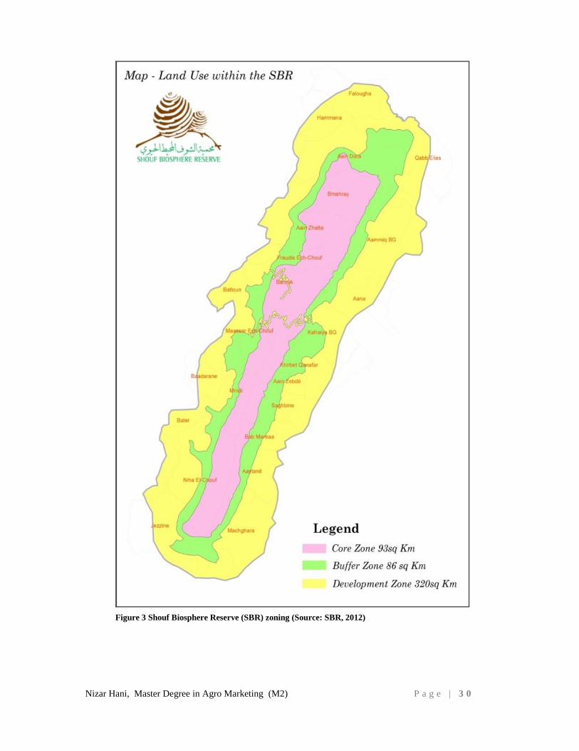
The following map represents the three zones (Figure 3).
Biosphere Reserve Zoning, (UNESCO,1995)
Biosphere reserves should contain one or more core zones, buffer zones, and a development zone to
accommodate their multiple functions
Core zone of the SBR is about 93 sq km. The main conservation objectives of the core zone are
the protection and rehabilitation of the SBR natural and cultural values.
Buffer zone of the SBR is about 83 sq km. It surrounds the core zone(s) where only activities
compatible with the conservation objectives can take place.
Transition zone (development zone) of the SBR is about 320 sq km. It includes all the villages
surrounding the SBR where sustainable resource management practices are promoted.
Nizar Hani, Master Degree in Agro Marketing (M2) P a g e | 3 0
Figure 2: Biosphere Reserve Zoning (Abu-Izzeddine F., 2013)
Figure 3 Shouf Biosphere Reserve (SBR) zoning (Source: SBR, 2012)
Nizar Hani, Master Degree in Agro Marketing (M2) P a g e | 3 1
C.2.2 Physical characteristics
C.2.2.1 Geology
The dominant geological feature of the SBR is Mount Lebanon, a high mountain range
running North-South the length of Lebanon and parallel to the Mediterranean coast
(Khalil W., 2012)32
.The SBR comprises rocks from the third geological era (Pliocene)
which has undergone major tectonic movement that divided Mount Lebanon into two
parallel parts. The eastern range is now called the Anti-Lebanon and the western range is
called Mount Lebanon.
These two mountain ranges are separated by the Bekaa Valley which is composed of
recent infill sediments making it an agriculturally fertile valley. From a geological point
of view this valley is very important as it is the northern extension of the Great Rift
Valley in Africa.
The whole of the Shouf Mountain is made up of cavernous limestone, with many surface
features such as dolines indicating the underlying cavernous form of the mountain range.
One particularly noteworthy cave, estimated to be 700 meters long, is located near Niha
village. Villagers report an abundance of stalactites and stalagmites and that there is an
underground body of water.
The geomorphology of the eastern slope SBR (historically known as the Barouk
mountain) is characterized by a diminishing steepness as we move from north to south.
The situation on the western slope is the opposite – an increasing steepness. South of
Dahr El Baidar is the highest peak on in the SBR at 2000 meters, and the mountain range
becomes increasingly narrow towards the south.
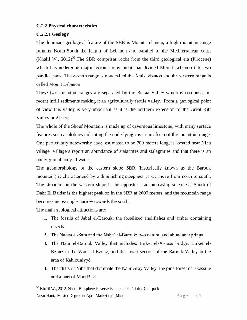
The main geological attractions are:
1. The fossils of Jabal el-Barouk: the fossilized shellfishes and amber containing
insects.
2. The Nabea el-Safa and the Nabe‘ el-Barouk: two natural and abundant springs.
3. The Nahr el-Barouk Valley that includes: Birket el-Arouss bridge, Birket el-
Bzouz in the Wadi el-Bzouz, and the lower section of the Barouk Valley in the
area of Kahlouniyyé.
4. The cliffs of Niha that dominate the Nahr Aray Valley, the pine forest of Bkassine
and a part of Marj Bisri
32
Khalil W., 2012. Shouf Biosphere Reserve is a potential Global Geo-park.
Nizar Hani, Master Degree in Agro Marketing (M2) P a g e | 3 2
5. The Nebi Ayyoub: a very important place of worship that offers a view of the
entire region
6. The cascades of Azzibé and Jezzine: they flow into the Nahr Aray Valley.
7. The Marj Bisri: it was formed by the millennial storage of fluvial deposits (from
the Quaternary).
Figure 4 Geological features of the Shouf Biosphere Reserve: Jabalel Barouk and Jabal Niha.
Source: “carte géologiques du Jabal el-Barouk et du Jabal Niha” – Extrait de la Carte geologique du Liban au 1:200.000e, dressee par Louis Duberetret, 1955.
Nizar Hani, Master Degree in Agro Marketing (M2) P a g e | 3 3
C.2.2.2 Soil
The physical characteristics of the soil of the SBR are homogenous belonging to the red
brown Mediterranean soils formed on hard marl limestone, are derived from Jurassic,
Balthonian, Callovian to Oxfordian-Portladian marl limestone, and the stone contents
range from 80-90%. (Abu-Izzeddine, F., 2012)
From an erosion point of view these soils are in a state of equilibrium due to high
permeability, mask of calcareous fragments, good vegetative cover, and good drainage.
C.2.2.3 Elevation
Highest elevation is 2000 meters and the lowest is 1000 meters.
C.2.2.4 Climate
A typical Mediterranean climate with four distinct seasons where the average temperature
of the warmest month (Aug) is 20 °C, and the coldest month (Jan) is 4 °C. The summers
are warm and dry while the winters are cool and wet. (Abu-Izzeddine, F., 2012)
C.2.2.5 Precipitation
Mean annual precipitation is 900 mm (recorded at an elevation of 1500 meters).
Precipitation is the source of both surface streams and groundwater - the major portion of
this occurs as rain, with snowfall at the upper elevations
C.2.2.6 Hydrology
Surface water flows originating on the range are mostly seasonal but some are perennial.
Underground water generates outflow rivers such as the Al Awali River (known as Al-
Barouk river) and Damour River (known as Al-Safa river). (Abu-Izzeddine, F., 2012)33
The summit of the range is considered as a divide between two hydrological systems
because of the difference between the two slopes of the mountain. The eastern slope is
much steeper and favors surface stream flows, whereas the western slope is less steep and
favors ground water aquifers.
The rivers that flow in the valleys are the major source of agriculture irrigation and
supply a dozen Shouf villages with domestic water and some of the western Bekaa
villages. It is also the main source of water for the Ammiq wetland in the Bekaa.
33
Abu-Izzedine F., September 2012. Shouf Biosphere Reserve management plan. Pages 16-25

Nizar Hani, Master Degree in Agro Marketing (M2) P a g e | 3 4
C.2.3. Natural characteristics
C.2.3.1 Landscape
The rugged undeveloped ridge system of Mount Lebanon forms a distinct skyline that is
enhanced in winter with a cover of snow and visible from great distances in all directions.
To the east of the
Mount Lebanon ridge
is the grandeur of the
Bekaa valley that is
vividly patterned by
green agricultural
fields that contrast
with the rugged
starkness of the Anti-
Lebanon Mountain
range. The most
spectacular feature of
the Anti-Lebanon range is Mount Hermon in the far south.
To the west of the Mount Lebanon ridge is the world famous cedar forests of the Shouf
region that give way to the surrounding villages with red tile roofs and fruit tree terraces.
In summer, small grassy meadows persist in doline depressions, and contrast with the
surrounding starkness of the white/gray limestone. On clear days the Mediterranean Sea
may be seen from the summit of the mountain range.
In the south the Qaraoun Lake sits between the eastern Anti-Lebanon mountain range and
the western Mount Lebanon range amid the agriculturally patterned landscape of the
Bekaa valley.
At the local/precinct level several of the cedar stands, in particular the Maasser Al-Shouf,
are recognized as outstanding scenic landscapes, the larger cedars contributing in a most
distinctive way to the landscape.
Individual trees can and do attract a lot of positive response from visitors to the area. The
aesthetic experience of seeing some of the larger cedars is undoubtedly enhanced for the
visitor by awareness of the important part they played in the history of Lebanon. These
Photo 1 The western mount Lebanon ridge covered by cedar forest (by Alaa
Monzer)
Nizar Hani, Master Degree in Agro Marketing (M2) P a g e | 3 5
elements of the Shouf Biosphere Reserve have always been, and continue to be, valued as
scenic landscapes.
C.2.3.2 Ecosystems
According to Corine Classification (1999)34
, the reserve belongs to three Mediterranean
levels:
1) the "Supra-Mediterranean Level" of vegetation which extends over the lower parts of
the eastern and western slopes up to 1500 meters of altitude, with oak trees as dominant
species, but on the western slopes the cedar trees dominate between 1250 - 1925 meters;
2) the "Montane Mediterranean Level" that covers both slopes between 1500 and 1900
meters with cedar dominant trees on the western slopes and absence of cedar trees on the
eastern slopes where the oak and azarole trees take place; and
3) the "Oro-Mediterranean level" of vegetation which extends above 1900 meters.
The list of SBR species includes 530 identified plant species distributed over 61 families.
The reserve provides habitat to 25 internationally and nationally threatened species, 48
endemic to Lebanon, or Lebanon and Syria, or Lebanon and Turkey, whilst 214 species
are restricted to the Eastern Mediterranean or Middle East area.
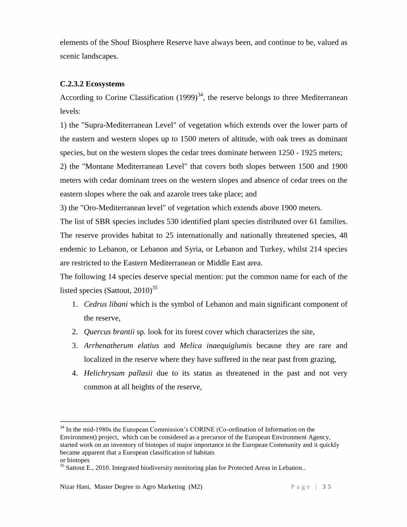
The following 14 species deserve special mention: put the common name for each of the
listed species (Sattout, 2010)35
1. Cedrus libani which is the symbol of Lebanon and main significant component of
the reserve,
2. Quercus brantii sp. look for its forest cover which characterizes the site,
3. Arrhenatherum elatius and Melica inaequiglumis because they are rare and
localized in the reserve where they have suffered in the near past from grazing,
4. Helichrysum pallasii due to its status as threatened in the past and not very
common at all heights of the reserve,
34
In the mid-1980s the European Commission’s CORINE (Co-ordination of Information on the
Environment) project, which can be considered as a precursor of the European Environment Agency,
started work on an inventory of biotopes of major importance in the European Community and it quickly
became apparent that a European classification of habitats
or biotopes 35
Sattout E., 2010. Integrated biodiversity monitoring plan for Protected Areas in Lebanon..
Nizar Hani, Master Degree in Agro Marketing (M2) P a g e | 3 6
5. Tulipa montana and Phytolacca pruinosa for their ornamental and economic
values and for the fact they are found in very limited numbers within the reserve.
6. Cephalaria cedrorum because of its endemism to Al-Shouf Cedar only,
7. Gundelia tournefortii as locally threatened because it is heavily collected and
uprooted by people and for its consuming value, high demand and high price,
8. Origanum ehrenbergii and Origanum syriacum as well as Rhus coriara which are
considered multipurpose species and consequently widely harvested by people,
and
9. Geum urbanum and Micromeria myrtifolia for being highly recommended
medicinal species.
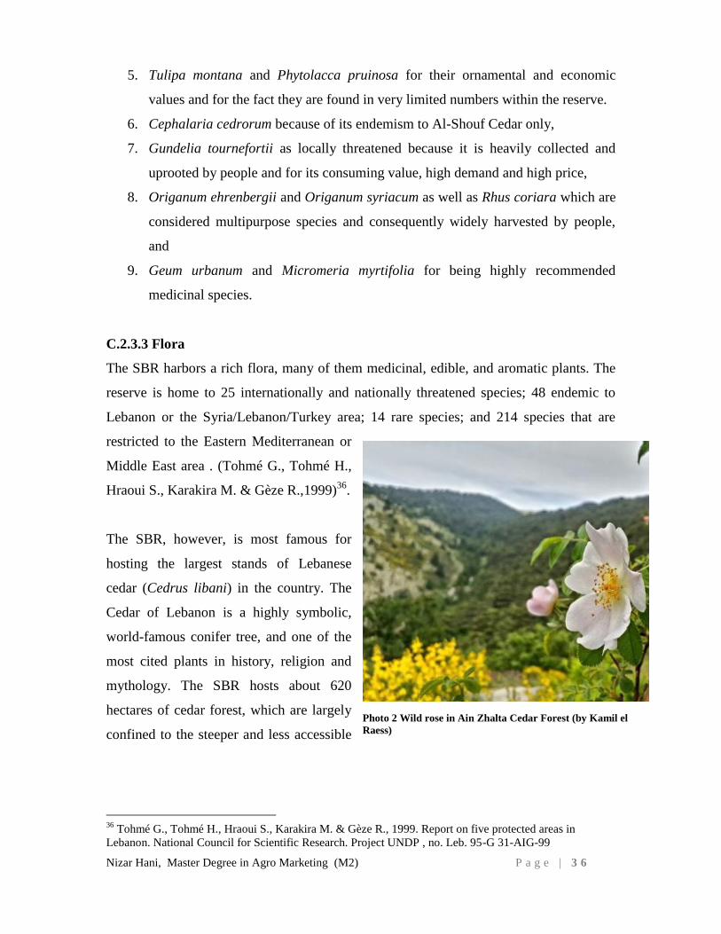
C.2.3.3 Flora
The SBR harbors a rich flora, many of them medicinal, edible, and aromatic plants. The
reserve is home to 25 internationally and nationally threatened species; 48 endemic to
Lebanon or the Syria/Lebanon/Turkey area; 14 rare species; and 214 species that are
restricted to the Eastern Mediterranean or
Middle East area . (Tohmé G., Tohmé H.,
Hraoui S., Karakira M. & Gèze R.,1999)36
.
The SBR, however, is most famous for
hosting the largest stands of Lebanese
cedar (Cedrus libani) in the country. The
Cedar of Lebanon is a highly symbolic,
world-famous conifer tree, and one of the
most cited plants in history, religion and
mythology. The SBR hosts about 620
hectares of cedar forest, which are largely
confined to the steeper and less accessible
36
Tohmé G., Tohmé H., Hraoui S., Karakira M. & Gèze R., 1999. Report on five protected areas in
Lebanon. National Council for Scientific Research. Project UNDP , no. Leb. 95-G 31-AIG-99
Photo 2 Wild rose in Ain Zhalta Cedar Forest (by Kamil el
Raess)
Nizar Hani, Master Degree in Agro Marketing (M2) P a g e | 3 7
areas. The SBR represents the natural southern limit of this tree. Nowadays the cedar
forest, protected from grazing and other human interference, is showing clear signs of
natural regeneration.
Whereas the cedars are found at the higher altitude of the western slopes of the Shouf, the
lower altitudes and eastern slopes are the domain of evergreen and broadleaf East
Mediterranean oaks, such as Quercus infectoria, Quercus calliprinos, and Quercus
brandti sp. Look – an endemic subspecies to the Reserve. Many of the oak forests have
been subject to regular harvesting for firewood and charcoal production, resulting in
extensive areas of coppiced oak woodland and low forest with shrub vegetation covering
most of the remaining areas.
Finally, a large portion of the SBR, especially in the most degraded areas (mostly above
1900 meters) is dominated by scrubland and high mountain pastures. These ecosystems
are particularly rich in aromatic, edible, and medicinal herbs and plants (Sattout et al,
2002)37
.
For the scientist, as well as the visitor, it is important to remember that human
intervention in the region of the SBR is as old as recorded history. From the pristine
forests mentioned in the Epic of Gilgamesh over 5000 years ago - to the exploited forests
during the Sumerian, Babylonian, Egyptian and Phoenician civilizations - to the heavy
cutting mentioned in the Old Testament for cedar and pine logs - to the more recent clear
cutting of remaining cedars, pines, oaks during the Ottoman Empire followed by the
French and British mandates – the area has had its share of uncontrolled human
intervention (Abu-Izzeddine,F. 2013)38
.
37
Sattout E. & S. N. Talhouk. 2001. A Proposed Monitoring Program for the Flora of the Natural Reserves
of Al-Shouf, Ehden and the Palm Islands. Ministry of Environment, Beirut, Lebanon & Green Line.
Lebanon.
38
Abu-Izzedine F., Shouf Biosphere Reserve, 2013. Memoirs of a Cedar, a history of deforestation, a future
of conservation. Page 7
Nizar Hani, Master Degree in Agro Marketing (M2) P a g e | 3 8
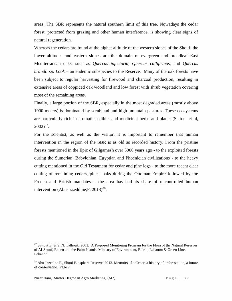
C.2.3.4 Mammals
The SBR is one of the last remaining areas in Lebanon where larger mammals that once
roamed the region can still be
found, such as the wolf, wild
boar and wild cat - or can be
reintroduced such as the ibex and
mountain gazelle.
Wolves are few and their
numbers are unlikely to hold a
stable population, due to the
absence of large herbivores on
which the wolf feeds. Striped
hyenas are found on the borders
of the reserve, mainly feeding on
the garbage dumps and agricultural crops of surrounding villages. Wild boar, wild cat and
jungle cat have all increased in numbers since the reserve was established, as well as the
jackal, red fox, porcupine, and squirrel. The gazelle is sporadic in the area (Abi Said M.,
2010)39
.
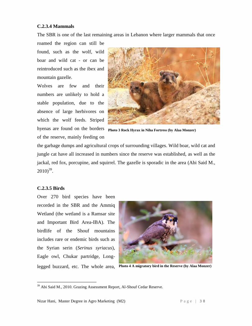
C.2.3.5 Birds
Over 270 bird species have been
recorded in the SBR and the Ammiq
Wetland (the wetland is a Ramsar site
and Important Bird Area-IBA). The
birdlife of the Shouf mountains
includes rare or endemic birds such as
the Syrian serin (Serinus syriacus),
Eagle owl, Chukar partridge, Long-
legged buzzard, etc. The whole area,
39
Abi Said M., 2010. Grazing Assessment Report, Al-Shouf Cedar Reserve.
Photo 3 Rock Hyrax in Niha Fortress (by Alaa Monzer)
Photo 4 A migratory bird in the Reserve (by Alaa Monzer)

Nizar Hani, Master Degree in Agro Marketing (M2) P a g e | 3 9
placed strategically between Europe, Africa, and West Asia, is very important for bird
migration. Every year countless storks, birds of prey and other migrants pass over the
SBR and use it as a roosting site (Jaradi G., et al, 2004)40
.
C.2.3.6 Reptiles and amphibians
The region contains 31 species, including chameleon, tortoise, and several species of
snakes, lizards, frogs, and toads ( (Jaradi G. et al.,2004)41
.
C.2.4 Socio-economic characteristics
C.2.4.1 Cultural heritage
The Shouf is a nexus of many cultures, religions, and historical events, all of which have
left an imprint that makes the area’s cultural heritage as rich as its ecosystems (Khalil W.,
2012)42
. The following are a few examples of its cultural and historical landmarks:
Nabi Ayyoub (Prophet Job): There is no exact date on the construction of this place of
worship. According to a popular tradition in Niha, the prophet Job became ill in Houran
and emigrated with his wife to settle
on a mountaintop in Niha el-Chouf
where he recovered. The site, in its
present form, dates back to 19th and
20th century.
Qalaat Niha (Niha Fortress) The
cave fortress of Niha is called Cave
of Tyron (Frankish sources) and
Chquif Tayroun (Arabic sources) .
It is carved into the rock of a cliff
overlooking the Bisri and the Aray valley. From its strategic location, it monitors the road
between Sidon and the Beqaa. This fortress is shaped like a cave and is over a hundred
40
Jaradi G., Abi Said M., Tohme G, Sadek R., 2004. Al-Chouf Cedar Nature Reserve. Biodiversity
Assessment and Monitoring in the Protected Areas. Final Report. National Center for Scientific Research.
Ministry of Environment, Lebanon. Pages 43-47
41
Jaradi G., Sadek R. & Abi Said Mounir, 2000. Fauna monitoring manual, part II. Protected areas project.
Green Line Association 42
Khalil W., 2012. Shouf Biosphere Reserve is a potential Global Geo-park.
Photo 5 Fakher eddine /Niha Fortress (by Nizar Hani)
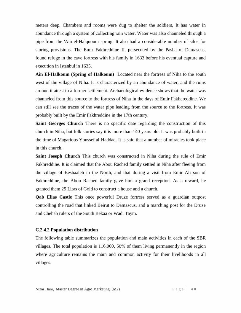
Nizar Hani, Master Degree in Agro Marketing (M2) P a g e | 4 0
meters deep. Chambers and rooms were dug to shelter the soldiers. It has water in
abundance through a system of collecting rain water. Water was also channeled through a
pipe from the 'Ain el-Halquoum spring. It also had a considerable number of silos for
storing provisions. The Emir Fakhreddine II, persecuted by the Pasha of Damascus,
found refuge in the cave fortress with his family in 1633 before his eventual capture and
execution in Istanbul in 1635.
Ain El-Halkoum (Spring of Halkoum) Located near the fortress of Niha to the south
west of the village of Niha. It is characterized by an abundance of water, and the ruins
around it attest to a former settlement. Archaeological evidence shows that the water was
channeled from this source to the fortress of Niha in the days of Emir Fakhereddine. We
can still see the traces of the water pipe leading from the source to the fortress. It was
probably built by the Emir Fakhreddine in the 17th century.
Saint Georges Church There is no specific date regarding the construction of this
church in Niha, but folk stories say it is more than 140 years old. It was probably built in
the time of Magarious Youssef al-Haddad. It is said that a number of miracles took place
in this church.
Saint Joseph Church This church was constructed in Niha during the rule of Emir
Fakhreddine. It is claimed that the Abou Rached family settled in Niha after fleeing from
the village of Beshaaleh in the North, and that during a visit from Emir Ali son of
Fakhreddine, the Abou Rached family gave him a grand reception. As a reward, he
granted them 25 Liras of Gold to construct a house and a church.
Qab Elias Castle This once powerful Druze fortress served as a guardian outpost
controlling the road that linked Beirut to Damascus, and a marching post for the Druze
and Chehab rulers of the South Bekaa or Wadi Taym.
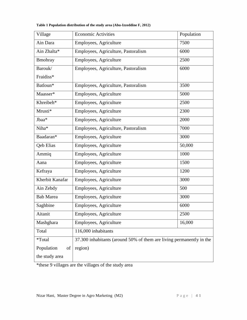
C.2.4.2 Population distribution
The following table summarizes the population and main activities in each of the SBR
villages. The total population is 116,000, 50% of them living permanently in the region
where agriculture remains the main and common activity for their livelihoods in all
villages.
Nizar Hani, Master Degree in Agro Marketing (M2) P a g e | 4 1
Table 1 Population distribution of the study area (Abu-Izzeddine F, 2012)
Village Economic Activities Population
Ain Dara Employees, Agriculture 7500
Ain Zhalta* Employees, Agriculture, Pastoralism 6000
Bmohray Employees, Agriculture 2500
Barouk/
Fraidiss*
Employees, Agriculture, Pastoralism 6000
Batloun* Employees, Agriculture, Pastoralism 3500
Maasser* Employees, Agriculture 5000
Khreibeh* Employees, Agriculture 2500
Mrusti* Employees, Agriculture 2300
Jbaa* Employees, Agriculture 2000
Niha* Employees, Agriculture, Pastoralism 7000
Baadaran* Employees, Agriculture 3000
Qeb Elias Employees, Agriculture 50,000
Ammiq Employees, Agriculture 1000
Aana Employees, Agriculture 1500
Kefraya Employees, Agriculture 1200
Kherbit Kanafar Employees, Agriculture 3000
Ain Zebdy Employees, Agriculture 500
Bab Marea Employees, Agriculture 3000
Saghbine Employees, Agriculture 6000
Aitanit Employees, Agriculture 2500
Mashghara Employees, Agriculture 16,000
Total 116,000 inhabitants
*Total
Population of
the study area
37.300 inhabitants (around 50% of them are living permanently in the
region)
*these 9 villages are the villages of the study area
Nizar Hani, Master Degree in Agro Marketing (M2) P a g e | 4 2
C.2.4.3 Demographic trends and human use
As mentioned above, most of the estimated 116,000 people who live in the villages
around the SBR depend on agricultural activities. However, an increasing number of
them are leaving their villages to become construction workers, government or private
sector employees, and small business entrepreneurs. The trend is towards a downscaling
of traditional agricultural activities as a result of an aging population, poor marketing
strategies, soil degradation, and excessive use of pesticides and fertilizers inducing high
production costs.
Unfortunately, security issues and political instability have also had a marked impact on
people's livelihoods. The 2006 war, in particular, was a breaking point, and economic
activity has not yet returned to pre-war status. The lack of employment opportunities has
led to increased migration, and local society is heavily dependent on revenues from
Lebanese who live and work abroad.
C.2.4.4 Historic land use prior to establishment of the nature reserve
The cedar forests of Lebanon are among the oldest documented (and used) forests in
history. The cedars were important enough in the history of man to be traceable to the
very earliest written records, that of the Sumerians in the third millennium BC. In the
ancient Sumerian story, “The Epic of Gilgamesh”, one of the oldest pieces of literature in
the world, the Cedars feature prominently. Gilgamesh has since been recognized as King
Gilgamesh of history and according to the epic he visited Mount Lebanon.
It was the Phoenicians along the coast of present-day Lebanon and from such ancient
cities as Byblos, Tyre and Sidon who became the principal dealers in the timber of the
cedar. Indeed, the cedars made a special contribution to the development of the
Phoenician civilization by providing the timbers with which they developed their famous
sea-going merchant boats thus becoming one of the first, if not the first major sea-going
trading nation in the world.
The Phoenicians traded the cedar to Egypt, until Egypt in turn conquered the land of the
cedars and gained direct access to the forests, which were highly prized in the building of
temples and boats. Later the Babylonians took a similar interest in the cedars and
obtained them for use in building the fabled city of Babylon.
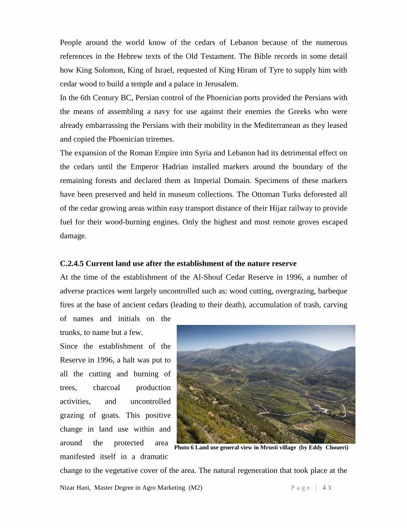
Nizar Hani, Master Degree in Agro Marketing (M2) P a g e | 4 3
People around the world know of the cedars of Lebanon because of the numerous
references in the Hebrew texts of the Old Testament. The Bible records in some detail
how King Solomon, King of Israel, requested of King Hiram of Tyre to supply him with
cedar wood to build a temple and a palace in Jerusalem.
In the 6th Century BC, Persian control of the Phoenician ports provided the Persians with
the means of assembling a navy for use against their enemies the Greeks who were
already embarrassing the Persians with their mobility in the Mediterranean as they leased
and copied the Phoenician triremes.
The expansion of the Roman Empire into Syria and Lebanon had its detrimental effect on
the cedars until the Emperor Hadrian installed markers around the boundary of the
remaining forests and declared them as Imperial Domain. Specimens of these markers
have been preserved and held in museum collections. The Ottoman Turks deforested all
of the cedar growing areas within easy transport distance of their Hijaz railway to provide
fuel for their wood-burning engines. Only the highest and most remote groves escaped
damage.
C.2.4.5 Current land use after the establishment of the nature reserve
At the time of the establishment of the Al-Shouf Cedar Reserve in 1996, a number of
adverse practices went largely uncontrolled such as: wood cutting, overgrazing, barbeque
fires at the base of ancient cedars (leading to their death), accumulation of trash, carving
of names and initials on the
trunks, to name but a few.
Since the establishment of the
Reserve in 1996, a halt was put to
all the cutting and burning of
trees, charcoal production
activities, and uncontrolled
grazing of goats. This positive
change in land use within and
around the protected area
manifested itself in a dramatic
change to the vegetative cover of the area. The natural regeneration that took place at the
Photo 6 Land use general view in Mrusti village (by Eddy Choueri)
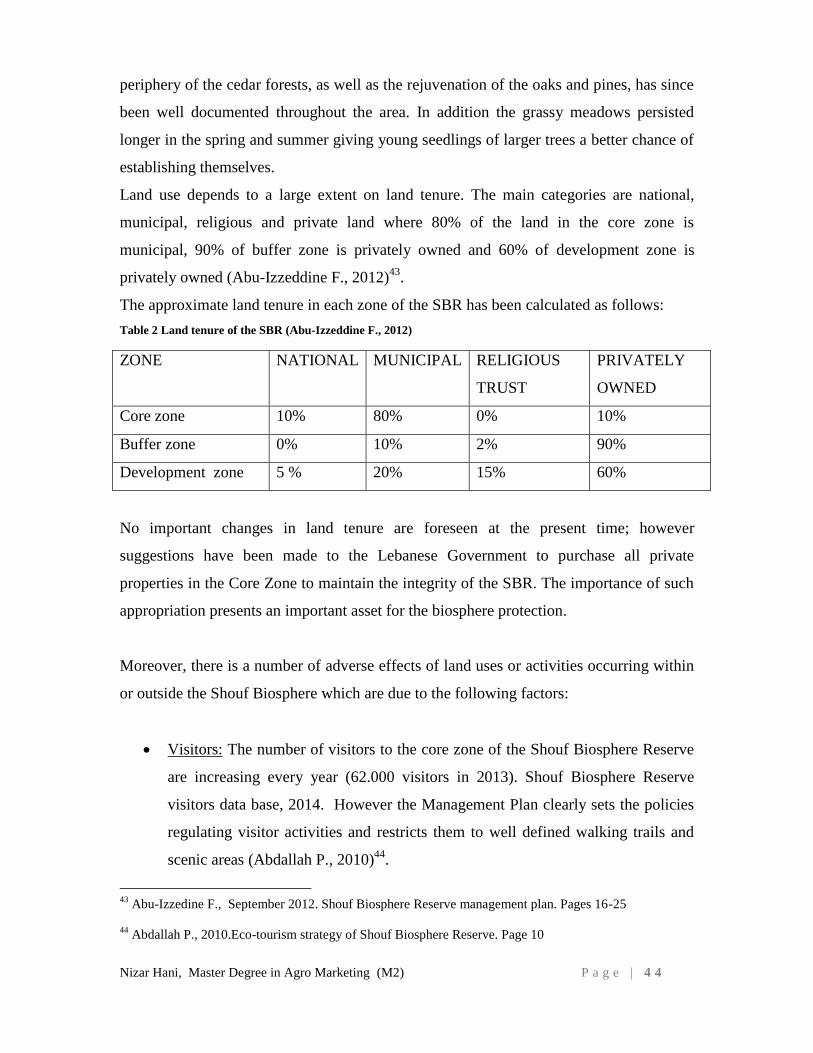
Nizar Hani, Master Degree in Agro Marketing (M2) P a g e | 4 4
periphery of the cedar forests, as well as the rejuvenation of the oaks and pines, has since
been well documented throughout the area. In addition the grassy meadows persisted
longer in the spring and summer giving young seedlings of larger trees a better chance of
establishing themselves.
Land use depends to a large extent on land tenure. The main categories are national,
municipal, religious and private land where 80% of the land in the core zone is
municipal, 90% of buffer zone is privately owned and 60% of development zone is
privately owned (Abu-Izzeddine F., 2012)43
.
The approximate land tenure in each zone of the SBR has been calculated as follows:
Table 2 Land tenure of the SBR (Abu-Izzeddine F., 2012)
ZONE NATIONAL MUNICIPAL RELIGIOUS
TRUST
PRIVATELY
OWNED
Core zone 10% 80% 0% 10%
Buffer zone 0% 10% 2% 90%
Development zone 5 % 20% 15% 60%
No important changes in land tenure are foreseen at the present time; however
suggestions have been made to the Lebanese Government to purchase all private
properties in the Core Zone to maintain the integrity of the SBR. The importance of such
appropriation presents an important asset for the biosphere protection.
Moreover, there is a number of adverse effects of land uses or activities occurring within
or outside the Shouf Biosphere which are due to the following factors:
Visitors: The number of visitors to the core zone of the Shouf Biosphere Reserve
are increasing every year (62.000 visitors in 2013). Shouf Biosphere Reserve
visitors data base, 2014. However the Management Plan clearly sets the policies
regulating visitor activities and restricts them to well defined walking trails and
scenic areas (Abdallah P., 2010)44
.
43
Abu-Izzedine F., September 2012. Shouf Biosphere Reserve management plan. Pages 16-25
44
Abdallah P., 2010.Eco-tourism strategy of Shouf Biosphere Reserve. Page 10
Nizar Hani, Master Degree in Agro Marketing (M2) P a g e | 4 5
Development activities: Housing estates, in the buffer and transition zones of the
SBR, are a potential threat. The declaration of a biosphere reserve in the area will
encourage a more responsible and sustainable approach to this activity (ECODIT,
2010)45
.
Hunting: The lack of enforcement of any rules or regulations concerning hunting
in Lebanon is a grave threat to all forms of wildlife, particularly birds (ECODIT,
2001)46
. The most serious threat is to migrating birds of prey during their bi-
annual passage over the SBR development zone.
C.2.4.6 Future land use as a biosphere reserve
The Shouf region already serves as a pilot site for promoting the sustainable development
of the region by encouraging the conservation of nature, environmental friendly
agriculture, preservation of water catchment areas, protection of scenic area, controlled
development, tourist facilities and clean roads. The SBR and the municipalities of the
region are at the forefront of the movement to improve the income generating capacity of
the area without causing irreversible harm to its natural resources (Abu-Izzeddine F.,
2012).47
45
ECODIT, 2010 . Business and Marketing plan for the rural products, Shouf Biosphere Reserve. Page 4
46
ECODIT, 2001. Lebanon State of the Environment Report (SOER). Lebanon : Ministry of Environment,
Lebanese Environment & Development Observatory (LEDO).
47
Abu-Izzedine F., September 2012. Shouf Biosphere Reserve management plan. Pages 16-25
Nizar Hani, Master Degree in Agro Marketing (M2) P a g e | 4 6
C.3. STATE OF THE AGRICULTURE IN LEBANON AND THE
SHOUF AREA
C.3.1: Agriculture in Lebanon Agriculture is a small part of the Lebanese economy and
has remained relatively stable as a share of GDP at an average of 6.4 percent annually
from 2001 to 2010 (Source: The World Bank)48
.This is significantly less than in
neighboring Arab countries and is consistent with Lebanon’s higher income, as well as its
more urbanized and diversified economy. Agriculture value added per square kilometer is
higher in Lebanon than in many nearby countries, reflecting a higher intensity of
production and greater production focus on higher value fruit and vegetables (FAO -
MOA, 2012)49
.
According to the most recent Agricultural Census (2010/11), the total agricultural area is
estimated at 332 000 hectares (32 percent of total surface area). A total of 230 000
hectares is cultivated of which half is irrigated. Land use in Lebanon has gradually
shifted from production systems based on cereals towards high value-added crops
(mainly fruits and vegetables). Total agricultural value production remained stable in the
last few years. The livestock sector contributes around 30 percent of the total value of
production.
Approximately 20 to 25 percent of Lebanon’s active population is involved in the
agriculture sector, including full-time and part-time workers as well as seasonal family
labour (FAO, 1991)50
. There are a total of 40 agricultural homogenous zones, which
possess very distinct socio-economic and geopolitical characteristics. For example, the
agricultural zones located in the Bekaa and northern Lebanon provinces cover 67 percent
of the total agricultural land and typically belong to large commercial farmers. In
contrast, southern zones comprise smaller farmers, many of whom live in remote rural
areas.
In many villages in the South as well as in Baalbeck and Hermel, which also are the
poorest sections of the country, agriculture is reported to contribute up to 80 percent of
the local GDP and represents the major income-earning and employment opportunity.
48
World Bank, 2009. Lebanon Agriculture Public Expenditure Review Note.
49
MOA - FAO, 2012. LEBANON Country Programming Framework 2012–2015 (Joint Statement of the
Ministry of Agriculture and FAO), pages 9-13.
50
FAO 1991. Technical report on land cover mapping of Lebanon. Remote sensing center, Rome.
Nizar Hani, Master Degree in Agro Marketing (M2) P a g e | 4 7
Throughout Lebanon, many of these people depend on agriculture as the primary source
of income and employment, particularly the poor. Over 20 percent of heads of
households engaged in the sector are very poor. Women farmers constitute some 9
percent of the total farmers. Women are involved mainly in the production of dairy
products, food preserves and subsistence farming.
Rural women are among the most vulnerable groups of the population, marked by an
increased incidence of poverty. Despite their significant contribution to farm activities,
rural women have long been deprived from effective participation in the decision-making
process. The contribution of women to the development process is rather underestimated
and undervalued as a result of a number of cultural and policy biases. Rural women still
face a number of constraints (legal, cultural, socio-economic) and challenges in rural
development, emphasized by gender bias in the delivery of rural services. Women access
to land, farm inputs, markets and marketing services in addition to appropriate
technology and extension services is challenged. The main issues include: (a) the
Lebanese labor law does not include any specific legislation or provisions that protect
and regulate rural women’s (or men’s) work, nor do they participate in the benefits of the
National Security Social Fund (NSSF); (b) women in rural areas have little access to
land, which is caused by legal (inheritance laws, property rights), economic and cultural
constraints. Most of the land parcels cultivated by women are fragmented (less than 0.6
ha) compared to 1.3 ha for the parcels operated by men; (c) technology transfer in rural
areas is generally not geared towards women’s needs and concerns; and (d) the lack of
access to credit is one of the most important challenges facing rural women. The limited
access of rural women to formal financial services is mainly due to (i) limited income
(subsistence agriculture), (ii) lack of collateral (land ownership), (iii) and other socio-
cultural constraints (FAO / MOA, 2012)51
.
Moreover, Lebanon has a youthful population, 45 percent of which is below the age of
youth unemployment rates in the country is at 22.6 percent (MOA, 2010)52
, almost twice
the overall unemployment rate, with young people constituting 70 percent of the total
51
MOA - FAO, 2012. LEBANON Country Programming Framework 2012–2015 (Joint Statement of the
Ministry of Agriculture and FAO), pages 9-13.
52
MOA, 2010. MOA Strategic Framework 2010-2014.
Nizar Hani, Master Degree in Agro Marketing (M2) P a g e | 4 8
unemployed population. Youth unemployment has been recognized as a major issue by
the government and as an obstacle to the development of Lebanese economy, including
the rural sectors. However, agriculture has the potential to generate decent job
opportunities for youth, addressing this major country issue, and could play an important
role in employment and pro-poor growth.
In recent years poverty and other social indicators have improved marginally in most
regions. However, around 28.5 percent of the Lebanese population is still considered as
living below the upper poverty line (estimated at US$4 per capita per day) of which 8
percent are under the lower poverty line (US$2.4 per capita per day),(UNDP, 2007)53
with large regional disparities in household consumption and poverty rates, being the
highest in the North (Akkar) followed by South, then Bekaa. Rural areas witness a higher
incidence of extreme poverty vs. suburban areas which have the highest number of poor;
rural areas are characterized by limited off-farm employment opportunities, with
agriculture being an important source of income. Rural poverty in remote areas is
correlated with low-income potential from agriculture where agriculture workers are
among the poorest in addition to female-headed households. In many cases, the poorest
households in rural areas rely on self-consumption.
A recent study revealed that direct income from agriculture accounts for about 52 percent
of total income in nine Agricultural Homogeneous Zones; the share of agricultural
income increases in low-income households (IFAD, 2007)54
. The agriculture component
of income is subject to climatic risks and lower production which might offset the
increase in output prices, if any, and thus increase vulnerability of low-income
households where agriculture constitutes a considerable source of income.
Lebanon is a net food importer. In 2011, Lebanon total agricultural and food imports
amounted to US$ 3181 million while agricultural and food exports were valued at US$
581 million. (FAO, 1999 & 2010)55
The country is highly vulnerable to price volatility of
53
UNDP, 2007. Poverty, Growth and Inequality study in Lebanon.
54
IFAD, 2007. Livelihoods and gender analysis of the war damage in rural areas of Lebanon.
55
FAO. 1999 & 2010. “Lebanese Observatory for Agricultural Development Project”, Agricultural Census
1999 and 2010.
Nizar Hani, Master Degree in Agro Marketing (M2) P a g e | 4 9
food and other agricultural commodities with a food import bill reaching US$2.6 billion
yearly.
Animal production is one of the major economic activities in the South and North of
Lebanon which represent the highest poverty indicators in the Country’s rural areas. The
animal production sector is considered the mainstay of the Southern, Norhern and Beqaa
rural economy and has a key impact on household well-being and poverty alleviation,
through: (i) generating cash income by sales of live and animal products; (ii) livestock
being one of the main users of manpower in rural areas as there are a few opportunities
for employment, such as industrial activities in South Lebanon; and (iii) most of the low
income rural families in rural Lebanon rely on livestock for food security, nutritional and
economic status. The traditional dairy products, particularly the “laban” and “labneh”
from goat and cows are the most popular protein sources in Lebanese culinary habit
which accompany daily food, providing high quality dietary protein for people, mainly
for children and women, and elderly .
The dairy sector is composed of many semi-artisanal plants which do not have good
control over milk quality and have a low innovation capacity in terms of cheese and dairy
products reference. Cattle meat production remains very limited, with livestock imported
from different countries (mainly EU) and slaughtered in Lebanon. The production of
sheep meat and milk suffers from competition from imported meat from Australia,
Turkey and Syria. The artisanal production of sheep milk not being constant over the
year, the dairy and cheese factories have to depend on other sources to maintain their
output. Goat production seems to be suffering as well, although the demand for goat meat
and milk products remains large and some 10 000 families have this production as their
major source of income.
Although some NGOs have implemented development projects for the support of goat
production, most herders still suffer from the lack of access to services, markets and
credits. In the dairy cattle small production system, women represent some 15 percent of
the total number of farmers. The different studies undertaken at national level show that
the young generation is no longer interested in the dairy or agriculture business; dairy
farmers aged less than 40 years represent only 28 percent; and 25 percent of dairy
farmers have large families with more than eight dependents. The large holdings
requiring important investments, the social status of their owners is by far different and
Nizar Hani, Master Degree in Agro Marketing (M2) P a g e | 5 0
not comparable by any means to that of the small holdings, except when it comes to the
workers within these large farms (FAO, 2011).
Almost 60 percent of livestock farmers depend on dairy as their main source of living,
while 20 percent depend on dairy with crops as a secondary source of income and 22
percent depend on dairy and other businesses such as casual daily work, trading,
retirement allowances, etc. With the exception of the large, modern dairy farm owners,
most dairy farmers (71 percent) rank as either poor or very poor for their living and
livelihood standards (FAO, 2011)56
.
The agricultural sector faces institutional, policy, technological and financial resources
constraints, resulting in the sector’s low performance. The interplay of all these
constraints results in: small and fragmented land holdings (70 percent of the total farm
holders have an area of less than one hectare, and cultivate less than 20 percent of the
total cropping area), low farmers' income resulting from low productivity; inequality in
ownership and access to productive assets, rural poverty, increased vulnerability of rural
women, and decreasing food security; (ii) lack of farmers' access to infrastructure
(irrigation networks, agricultural roads, marketing outlets for agricultural and agro
processed products); (iii) widespread use of foreign labor; (iv) rural-urban migration; (v)
insufficient knowledge of modern techniques and environment-friendly practices,
excessive use of pesticides; (vi) high cost of production resulting from high costs of
inputs, labor, and energy; (vii) degradation of natural resources; and (viii) low
competitiveness of the agricultural products coupled with an increase in the agricultural
trade deficit. Poor management of natural resources hinders the development of the
agriculture sector. Scarce mobilization, storage and distribution of irrigation water are
currently limiting the expansion of agricultural production; farmers in rural areas often
lack required investments for water harvesting and for developing modern irrigation
techniques. In 2010, agriculture water demand was estimated at 900 million m3 (60
percent of total). According to the projections of the World Bank, the total exploited
resources (about 1 500 million m3) do not meet the current annual demand and the
projected demand after 2020 would exceed exploitable renewable resources (2000–2500
million m3). Despite investments in expanding water supply networks, developing
56
FAO, Asmar F., 2011. Country Pasture/Forage Resource Profiles.
Nizar Hani, Master Degree in Agro Marketing (M2) P a g e | 5 1
additional water resources, developing capacities of concerned institutions and improving
service delivery, overall progress has been slow.
In addition, while forests represent a precious source of income for rural populations,
several hazards are leading to the degradation of forests and rangelands (including fires,
adverse climate, pest outbreaks, overgrazing, unsuitable practices). Forest area is
estimated at 139136 hectares while other wooded lands cover 108378 hectares making
about 23 percent of green cover in the total area of the country. (FAO, 2010)57
C.3.2: Agriculture in the Shouf Area
The mountainous upper Shouf is known for diverse microclimates that allow the
production of many different crops: olive trees (50% of the cultivated area in
Mountainous Shouf area), fruit trees like apples, peaches, cherries, and grapes (38% of
cultivated land in Mountainous Shouf area) in addition to vegetables (MOA, 2006)58
. The
upper Shouf depends largely on agricultural production and has little industrial
production. Like Lebanese farmers, Shouf farmers sell their products to local residents
but they mainly depend on external markets through the middlemen. Fifty percent of the
local community and the families from the study area are living in the city mainly in
Beirut suburb.
Most of the people who inhabit the villages of the SBR rely on agricultural activities. In
the winter season, some of them become construction workers, and a few are also
employees of small businesses and government workers (police, army, etc.). The general
trend is that of a downscaling of traditional agricultural activities, mainly due to an aging
resident population, poor marketing strategies and low competitively on the national
markets, and soil impoverishment due to the intensive use of chemical pesticides and
fertilizers (Pagliani M., 2009)59
.
57
FAO, MOA, 2010. National Forest Assessment program.
58
Ministry of Agriculture/Lebanon and United nations Environment Programme (UNEP), 1996. Biological
Diversity of Lebanon – Country Study Report.
59
Pagliani M., IUCN, 2009. Shouf Biosphere Reserve Program Portfolio.

Nizar Hani, Master Degree in Agro Marketing (M2) P a g e | 5 2
Most of the people are employees (60 %), farmers (15%), merchandises who owning
groceries and other small shops (15%), and working abroad (10%) (Hani N., 2013)60
.
60
Hani N., 2013. Project proposal prepared by the municipality of Barouk and submitted to US
International Development Agency – USAID, page 8
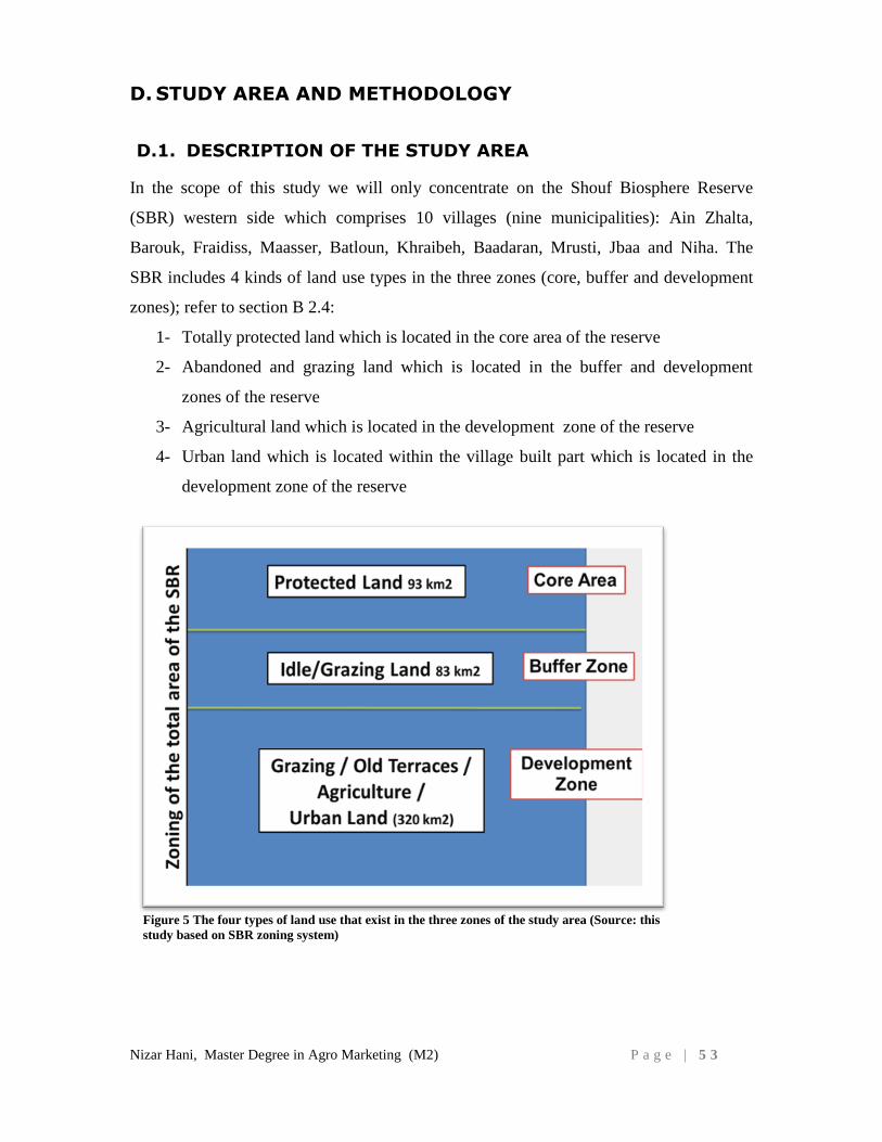
Nizar Hani, Master Degree in Agro Marketing (M2) P a g e | 5 3
D. STUDY AREA AND METHODOLOGY
D.1. DESCRIPTION OF THE STUDY AREA
In the scope of this study we will only concentrate on the Shouf Biosphere Reserve
(SBR) western side which comprises 10 villages (nine municipalities): Ain Zhalta,
Barouk, Fraidiss, Maasser, Batloun, Khraibeh, Baadaran, Mrusti, Jbaa and Niha. The
SBR includes 4 kinds of land use types in the three zones (core, buffer and development
zones); refer to section B 2.4:
1- Totally protected land which is located in the core area of the reserve
2- Abandoned and grazing land which is located in the buffer and development
zones of the reserve
3- Agricultural land which is located in the development zone of the reserve
4- Urban land which is located within the village built part which is located in the
development zone of the reserve
Figure 5 The four types of land use that exist in the three zones of the study area (Source: this
study based on SBR zoning system)
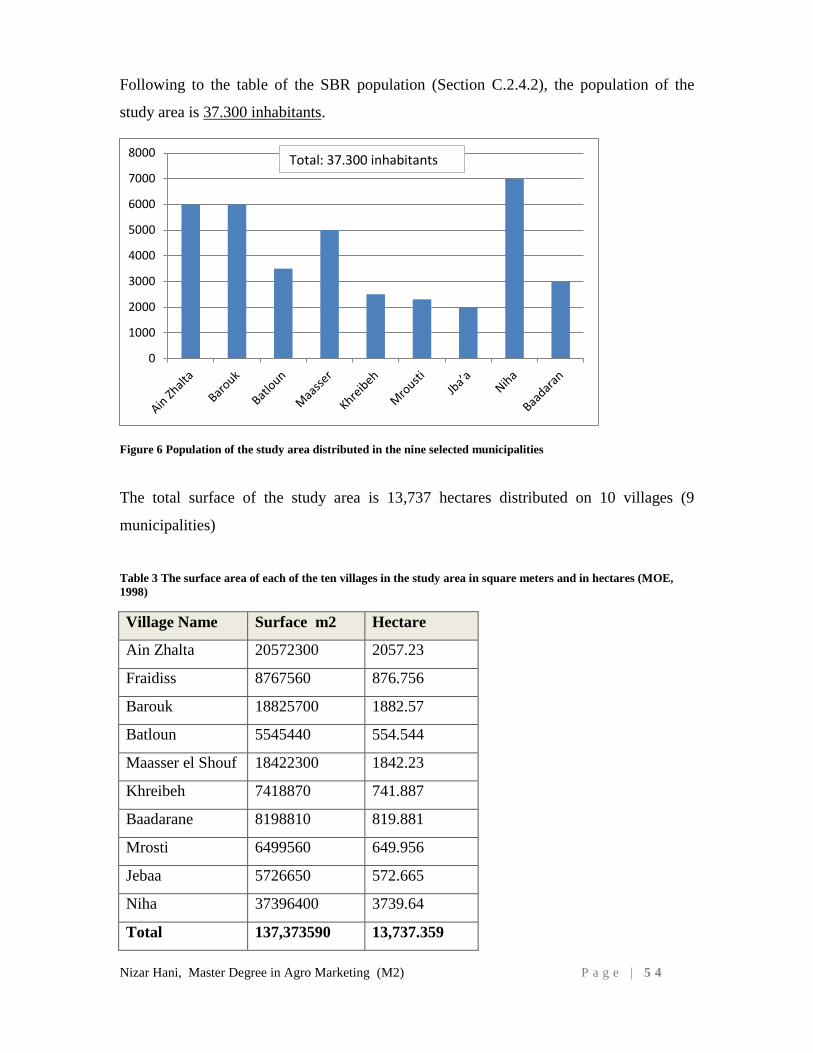
Nizar Hani, Master Degree in Agro Marketing (M2) P a g e | 5 4
Following to the table of the SBR population (Section C.2.4.2), the population of the
study area is 37.300 inhabitants.
The total surface of the study area is 13,737 hectares distributed on 10 villages (9
municipalities)
Table 3 The surface area of each of the ten villages in the study area in square meters and in hectares (MOE,
1998)
Village Name Surface m2 Hectare
Ain Zhalta 20572300 2057.23
Fraidiss 8767560 876.756
Barouk 18825700 1882.57
Batloun 5545440 554.544
Maasser el Shouf 18422300 1842.23
Khreibeh 7418870 741.887
Baadarane 8198810 819.881
Mrosti 6499560 649.956
Jebaa 5726650 572.665
Niha 37396400 3739.64
Total 137,373590 13,737.359
0
1000
2000
3000
4000
5000
6000
7000
8000Total: 37.300 inhabitants
Figure 6 Population of the study area distributed in the nine selected municipalities
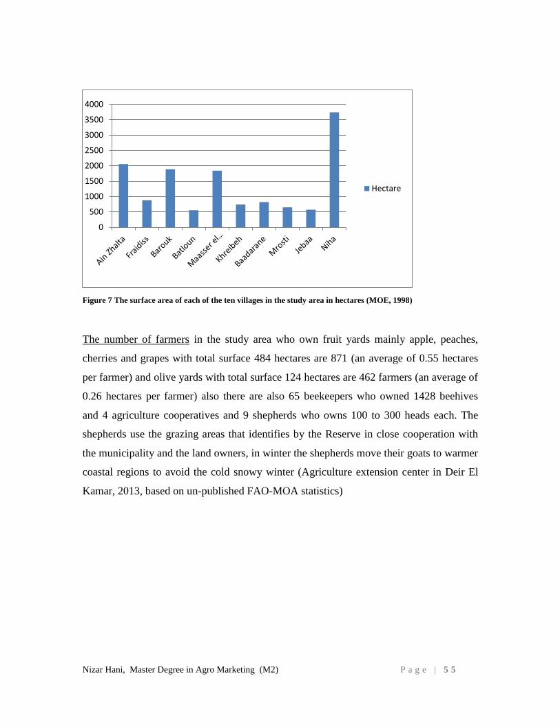
Nizar Hani, Master Degree in Agro Marketing (M2) P a g e | 5 5
Figure 7 The surface area of each of the ten villages in the study area in hectares (MOE, 1998)
The number of farmers in the study area who own fruit yards mainly apple, peaches,
cherries and grapes with total surface 484 hectares are 871 (an average of 0.55 hectares
per farmer) and olive yards with total surface 124 hectares are 462 farmers (an average of
0.26 hectares per farmer) also there are also 65 beekeepers who owned 1428 beehives
and 4 agriculture cooperatives and 9 shepherds who owns 100 to 300 heads each. The
shepherds use the grazing areas that identifies by the Reserve in close cooperation with
the municipality and the land owners, in winter the shepherds move their goats to warmer
coastal regions to avoid the cold snowy winter (Agriculture extension center in Deir El
Kamar, 2013, based on un-published FAO-MOA statistics)
0
500
1000
1500
2000
2500
3000
3500
4000
Hectare
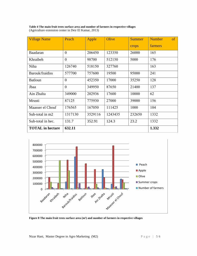
Nizar Hani, Master Degree in Agro Marketing (M2) P a g e | 5 6
Table 4 The main fruit trees surface area and number of farmers in respective villages
(Agriculture extension center in Deir El Kamar, 2013)
Figure 8 The main fruit trees surface area (m²) and number of farmers in respective villages
0
100000
200000
300000
400000
500000
600000
700000
800000
Peach
Apple
Olive
Summer crops
Number of farmers
Village Name Peach Apple Olive Summer
crops
Number of
farmers
Baadaran 0 206450 123350 26000 165
Khraibeh 0 98700 512150 5000 176
Niha 126740 518150 327760 163
Barouk/fraidiss 577700 757600 19500 95000 241
Batloun 0 452350 17000 35250 128
Jbaa 0 349950 87650 21400 137
Ain Zhalta 349000 202936 17600 10000 62
Mrusti 87125 775930 27000 39000 156
Maasser el Chouf 176565 167050 111425 1000 104
Sub-total in m2 1317130 3529116 1243435 232650 1332
Sub-total in hec. 131.7 352.91 124.3 23.2 1332
TOTAL in hectare 632.11 1.332
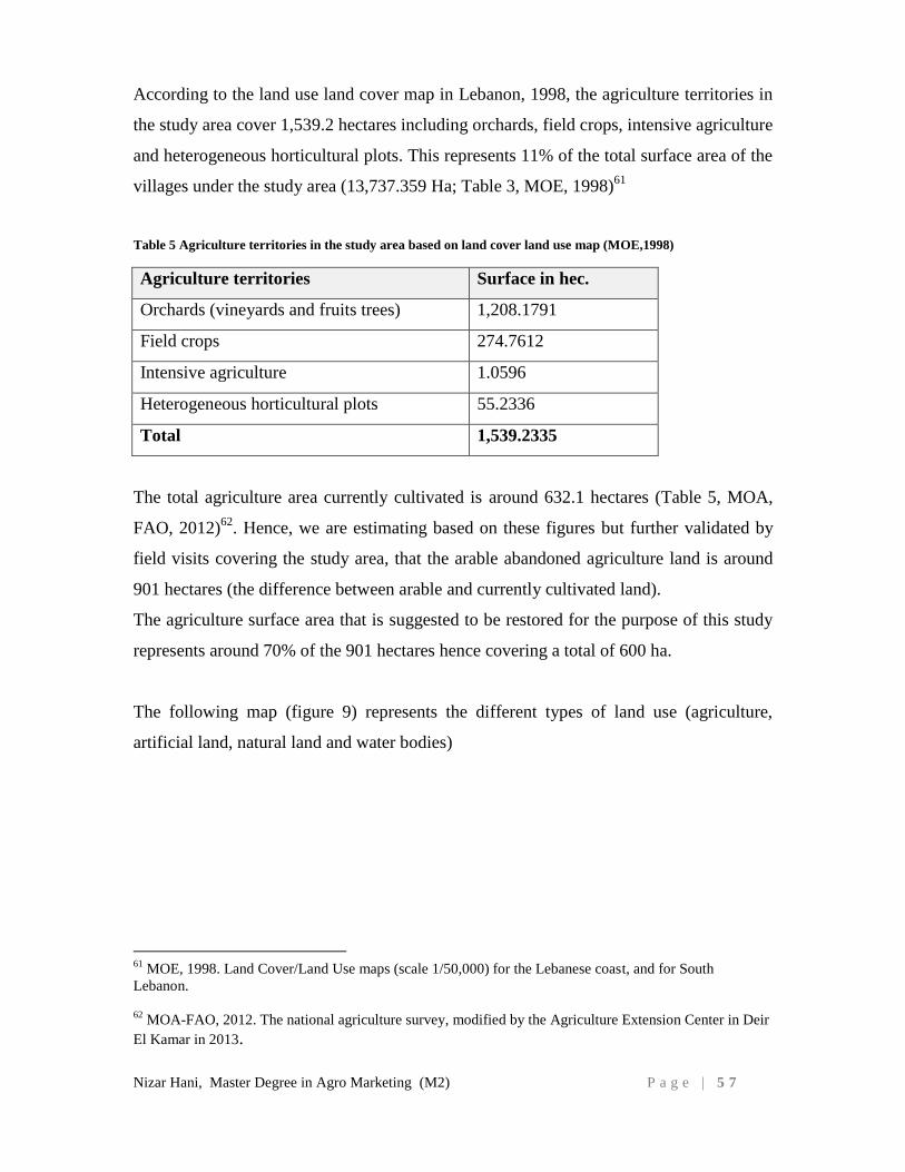
Nizar Hani, Master Degree in Agro Marketing (M2) P a g e | 5 7
According to the land use land cover map in Lebanon, 1998, the agriculture territories in
the study area cover 1,539.2 hectares including orchards, field crops, intensive agriculture
and heterogeneous horticultural plots. This represents 11% of the total surface area of the
villages under the study area (13,737.359 Ha; Table 3, MOE, 1998)61
Table 5 Agriculture territories in the study area based on land cover land use map (MOE,1998)
Agriculture territories Surface in hec.
Orchards (vineyards and fruits trees) 1,208.1791
Field crops 274.7612
Intensive agriculture 1.0596
Heterogeneous horticultural plots 55.2336
Total 1,539.2335
The total agriculture area currently cultivated is around 632.1 hectares (Table 5, MOA,
FAO, 2012)62
. Hence, we are estimating based on these figures but further validated by
field visits covering the study area, that the arable abandoned agriculture land is around
901 hectares (the difference between arable and currently cultivated land).
The agriculture surface area that is suggested to be restored for the purpose of this study
represents around 70% of the 901 hectares hence covering a total of 600 ha.
The following map (figure 9) represents the different types of land use (agriculture,
artificial land, natural land and water bodies)
61
MOE, 1998. Land Cover/Land Use maps (scale 1/50,000) for the Lebanese coast, and for South
Lebanon.
62
MOA-FAO, 2012. The national agriculture survey, modified by the Agriculture Extension Center in Deir
El Kamar in 2013.
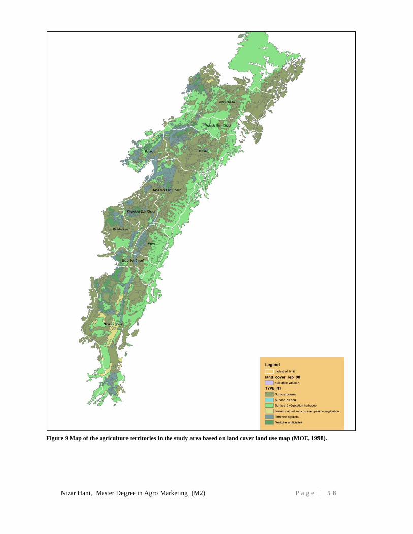
Nizar Hani, Master Degree in Agro Marketing (M2) P a g e | 5 8
Figure 9 Map of the agriculture territories in the study area based on land cover land use map (MOE, 1998).
Nizar Hani, Master Degree in Agro Marketing (M2) P a g e | 5 9
D.2. AGRICULTURE CHALLENGES IN THE STUDY AREA
Although the Shouf region is in better socio-economic shape than other parts of the
country, the whole area is facing several serious challenges. The socio-economic picture
is subject to a negative trend, because of continued central government inability, lack of
resources and human capacity, and economic hardship. Moreover, security issues and
political instability are having a marked adverse impact on people's livelihoods: the 2006
war, in particular, was a breaking point, and economic activity has not yet returned to
pre-war status. The lack of employment opportunities is leading to increased migration to
the cities and abroad, and the local society is heavily dependent on the revenues from the
Diaspora (Pagliani M., 2009)63
.
Lebanon exports agricultural products to many Arab countries through the Syrian
gateway. The closing of the Syrian gateway has had negative repercussions on Lebanese
and Shouf farmers. According to the head of the Farmers’ Syndicate, at least four ships
would be needed for the sea transportation to become a full alternative to the Syria route
(the cost per truck for the trip to Aqaba would be $2,000). (Daily Star, 2013)64
.
According to the Investment Development Authority of Lebanon (IDAL), agricultural
exports fell in 2011 to reach only 504,000 tons after the beginning of civil unrest in Syria
(IDAL, 2013)65
.
All the above old and new reasons in addition to the civil war lead for the agricultural
land abandonment in the study area.
D.3. DESCRIPTION OF THE FOUR ECOSYSTEM RESTORATION
SCENARIOS:
In the aim of restoring un-built land in the study area, the present study describes and
analyzes different scenarios of restoration. Two of these scenarios were developed and
suggested by a study conducted in 2013(Calmer R., et al, 2013) 66 by the Shouf
63
Pagliani M., IUCN, 2009. Shouf Biosphere Reserve Program Portfolio. 64
Halawi D., June 1, 2009. Organic farmers in Lebanon face export hurdles, Daily Star Lebanon. 65
IDAL, 2013. Lebanon agriculture fact sheet.
66
Colomer R., Regato P., 2013. Shouf Biosphere Reserve Ecosystem Restoration Plan. Pages 24-41
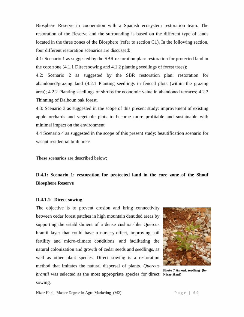
Nizar Hani, Master Degree in Agro Marketing (M2) P a g e | 6 0
Biosphere Reserve in cooperation with a Spanish ecosystem restoration team. The
restoration of the Reserve and the surrounding is based on the different type of lands
located in the three zones of the Biosphere (refer to section C1). In the following section,
four different restoration scenarios are discussed:
4.1: Scenario 1 as suggested by the SBR restoration plan: restoration for protected land in
the core zone (4.1.1 Direct sowing and 4.1.2 planting seedlings of forest trees);
4.2: Scenario 2 as suggested by the SBR restoration plan: restoration for
abandoned/grazing land (4.2.1 Planting seedlings in fenced plots (within the grazing
area); 4.2.2 Planting seedlings of shrubs for economic value in abandoned terraces; 4.2.3
Thinning of Dalboun oak forest.
4.3: Scenario 3 as suggested in the scope of this present study: improvement of existing
apple orchards and vegetable plots to become more profitable and sustainable with
minimal impact on the environment
4.4 Scenario 4 as suggested in the scope of this present study: beautification scenario for
vacant residential built areas
These scenarios are described below:
D.4.1: Scenario 1: restoration for protected land in the core zone of the Shouf
Biosphere Reserve
D.4.1.1: Direct sowing
The objective is to prevent erosion and bring connectivity
between cedar forest patches in high mountain denuded areas by
supporting the establishment of a dense cushion-like Quercus
brantii layer that could have a nursery-effect, improving soil
fertility and micro-climate conditions, and facilitating the
natural colonization and growth of cedar seeds and seedlings, as
well as other plant species. Direct sowing is a restoration
method that imitates the natural dispersal of plants. Quercus
brantii was selected as the most appropriate species for direct
sowing.
Photo 7 An oak seedling (by
Nizar Hani)
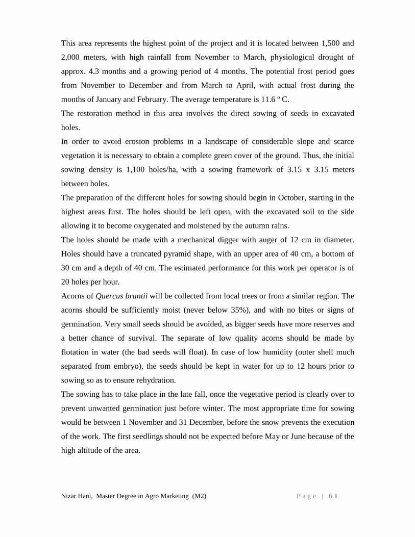
Nizar Hani, Master Degree in Agro Marketing (M2) P a g e | 6 1
This area represents the highest point of the project and it is located between 1,500 and
2,000 meters, with high rainfall from November to March, physiological drought of
approx. 4.3 months and a growing period of 4 months. The potential frost period goes
from November to December and from March to April, with actual frost during the
months of January and February. The average temperature is 11.6 º C.
The restoration method in this area involves the direct sowing of seeds in excavated
holes.
In order to avoid erosion problems in a landscape of considerable slope and scarce
vegetation it is necessary to obtain a complete green cover of the ground. Thus, the initial
sowing density is 1,100 holes/ha, with a sowing framework of 3.15 x 3.15 meters
between holes.
The preparation of the different holes for sowing should begin in October, starting in the
highest areas first. The holes should be left open, with the excavated soil to the side
allowing it to become oxygenated and moistened by the autumn rains.
The holes should be made with a mechanical digger with auger of 12 cm in diameter.
Holes should have a truncated pyramid shape, with an upper area of 40 cm, a bottom of
30 cm and a depth of 40 cm. The estimated performance for this work per operator is of
20 holes per hour.
Acorns of Quercus brantii will be collected from local trees or from a similar region. The
acorns should be sufficiently moist (never below 35%), and with no bites or signs of
germination. Very small seeds should be avoided, as bigger seeds have more reserves and
a better chance of survival. The separate of low quality acorns should be made by
flotation in water (the bad seeds will float). In case of low humidity (outer shell much
separated from embryo), the seeds should be kept in water for up to 12 hours prior to
sowing so as to ensure rehydration.
The sowing has to take place in the late fall, once the vegetative period is clearly over to
prevent unwanted germination just before winter. The most appropriate time for sowing
would be between 1 November and 31 December, before the snow prevents the execution
of the work. The first seedlings should not be expected before May or June because of the
high altitude of the area.
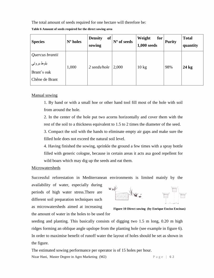
Nizar Hani, Master Degree in Agro Marketing (M2) P a g e | 6 2
The total amount of seeds required for one hectare will therefore be:
Table 6 Amount of seeds required for the direct sowing area
Species Nº holes Density of
sowing Nº of seeds
Weight for
1,000 seeds Purity
Total
quantity
Quercus brantii
بروتي بلوط
Brantʼs oak
Chêne de Brant
1,000 2 seeds/hole 2,000 10 kg 98% 24 kg
Manual sowing
1. By hand or with a small hoe or other hand tool fill most of the hole with soil
from around the hole.
2. In the center of the hole put two acorns horizontally and cover them with the
rest of the soil to a thickness equivalent to 1.5 to 2 times the diameter of the seed.
3. Compact the soil with the hands to eliminate empty air gaps and make sure the
filled hole does not exceed the natural soil level.
4. Having finished the sowing, sprinkle the ground a few times with a spray bottle
filled with generic cologne, because in certain areas it acts asa good repellent for
wild boars which may dig up the seeds and eat them.
Microwatersheds
Successful reforestation in Mediterranean environments is limited mainly by the
availability of water, especially during
periods of high water stress.There are
different soil preparation techniques such
as microwatersheds aimed at increasing
the amount of water in the holes to be used for
seeding and planting. This basically consists of digging two 1.5 m long, 0.20 m high
ridges forming an oblique angle upslope from the planting hole (see example in figure 6).
In order to maximise benefit of runoff water the layout of holes should be set as shown in
the figure.
The estimated sowing performance per operator is of 15 holes per hour.
Figure 10 Direct sowing (by Enrique Enciso Encinas)
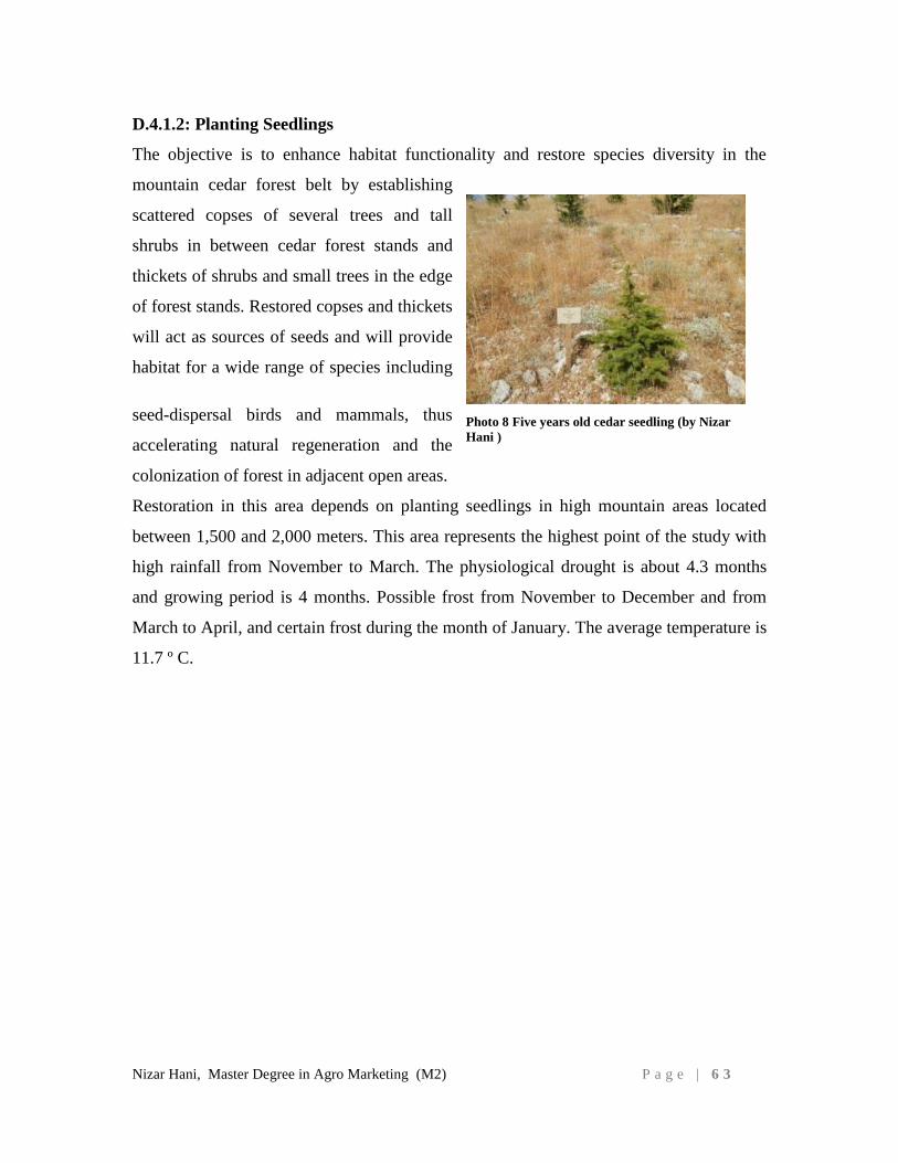
Nizar Hani, Master Degree in Agro Marketing (M2) P a g e | 6 3
D.4.1.2: Planting Seedlings
The objective is to enhance habitat functionality and restore species diversity in the
mountain cedar forest belt by establishing
scattered copses of several trees and tall
shrubs in between cedar forest stands and
thickets of shrubs and small trees in the edge
of forest stands. Restored copses and thickets
will act as sources of seeds and will provide
habitat for a wide range of species including
seed-dispersal birds and mammals, thus
accelerating natural regeneration and the
colonization of forest in adjacent open areas.
Restoration in this area depends on planting seedlings in high mountain areas located
between 1,500 and 2,000 meters. This area represents the highest point of the study with
high rainfall from November to March. The physiological drought is about 4.3 months
and growing period is 4 months. Possible frost from November to December and from
March to April, and certain frost during the month of January. The average temperature is
11.7 º C.
Photo 8 Five years old cedar seedling (by Nizar
Hani )
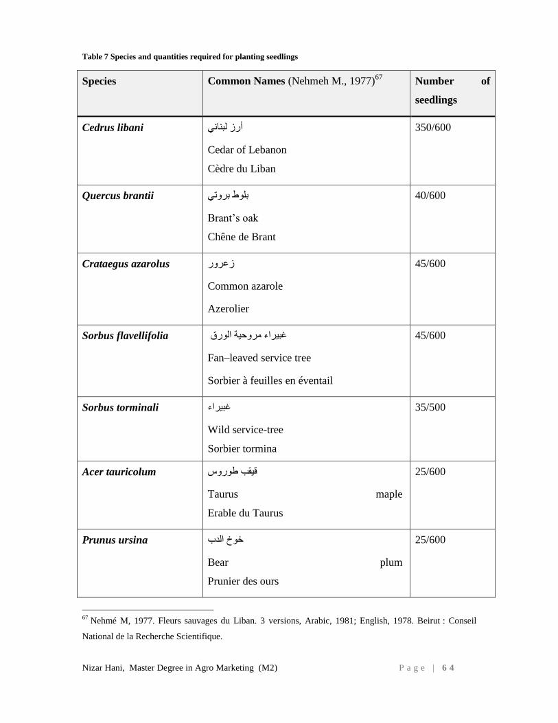
Nizar Hani, Master Degree in Agro Marketing (M2) P a g e | 6 4
Table 7 Species and quantities required for planting seedlings
Species Common Names (Nehmeh M., 1977)67
Number of
seedlings
Cedrus libani أرز لبناني
Cedar of Lebanon
Cèdre du Liban
350/600
Quercus brantii بروتي بلوط
Brantʼs oak
Chêne de Brant
40/600
Crataegus azarolus زعرور
Common azarole
Azerolier
45/600
Sorbus flavellifolia غبيراء مروحية الورق
Fan–leaved service tree
Sorbier à feuilles en éventail
45/600
Sorbus torminali غبيراء
Wild service-tree
Sorbier tormina
35/500
Acer tauricolum قيقب طوروس
Taurus maple
Erable du Taurus
25/600
Prunus ursina خوخ الدب
Bear plum
Prunier des ours
25/600
67
Nehmé M, 1977. Fleurs sauvages du Liban. 3 versions, Arabic, 1981; English, 1978. Beirut : Conseil
National de la Recherche Scientifique.
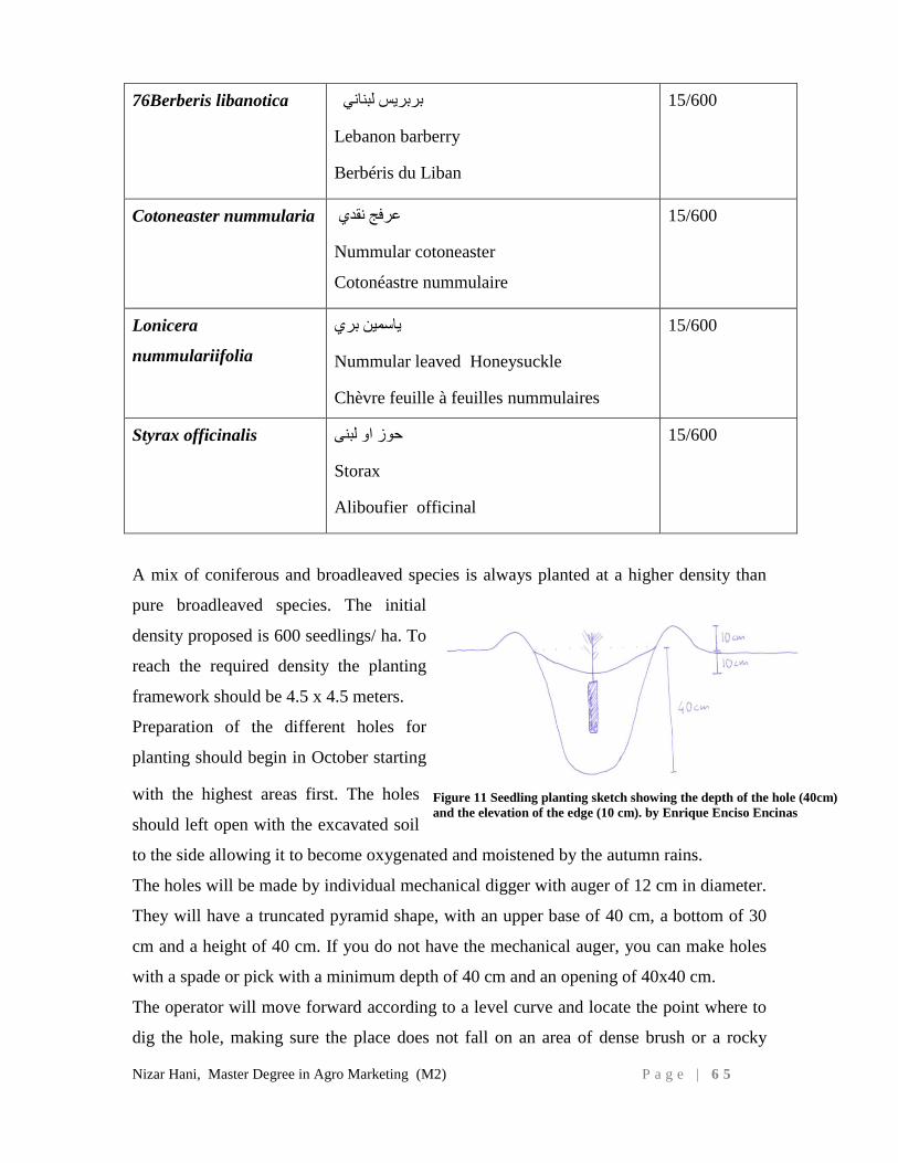
Nizar Hani, Master Degree in Agro Marketing (M2) P a g e | 6 5
76Berberis libanotica بربريس لبناني
Lebanon barberry
Berbéris du Liban
15/600
Cotoneaster nummularia عرفج نقدي
Nummular cotoneaster
Cotonéastre nummulaire
15/600
Lonicera
nummulariifolia
ياسمين بري
Nummular leaved Honeysuckle
Chèvre feuille à feuilles nummulaires
15/600
Styrax officinalis حوز او لبنى
Storax
Aliboufier officinal
15/600
A mix of coniferous and broadleaved species is always planted at a higher density than
pure broadleaved species. The initial
density proposed is 600 seedlings/ ha. To
reach the required density the planting
framework should be 4.5 x 4.5 meters.
Preparation of the different holes for
planting should begin in October starting
with the highest areas first. The holes
should left open with the excavated soil
to the side allowing it to become oxygenated and moistened by the autumn rains.
The holes will be made by individual mechanical digger with auger of 12 cm in diameter.
They will have a truncated pyramid shape, with an upper base of 40 cm, a bottom of 30
cm and a height of 40 cm. If you do not have the mechanical auger, you can make holes
with a spade or pick with a minimum depth of 40 cm and an opening of 40x40 cm.
The operator will move forward according to a level curve and locate the point where to
dig the hole, making sure the place does not fall on an area of dense brush or a rocky
Figure 11 Seedling planting sketch showing the depth of the hole (40cm)
and the elevation of the edge (10 cm). by Enrique Enciso Encinas
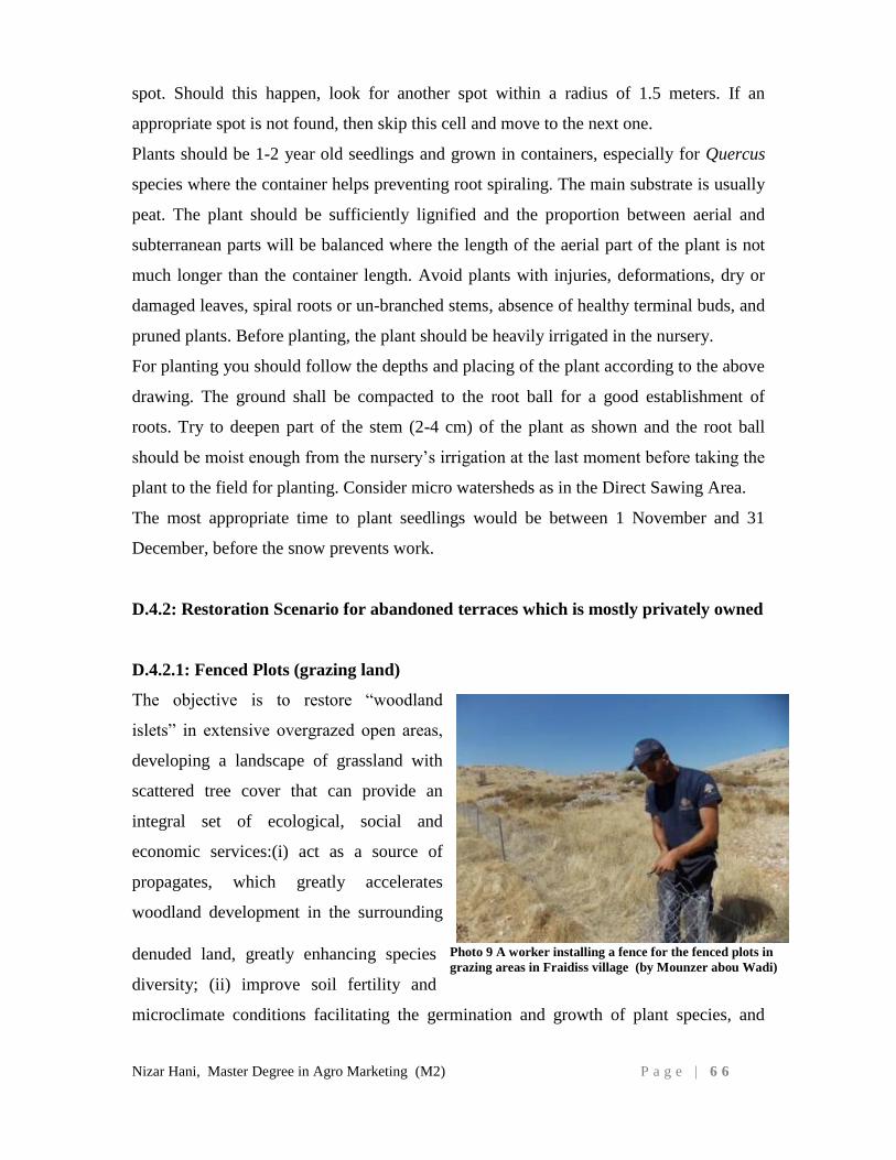
Nizar Hani, Master Degree in Agro Marketing (M2) P a g e | 6 6
spot. Should this happen, look for another spot within a radius of 1.5 meters. If an
appropriate spot is not found, then skip this cell and move to the next one.
Plants should be 1-2 year old seedlings and grown in containers, especially for Quercus
species where the container helps preventing root spiraling. The main substrate is usually
peat. The plant should be sufficiently lignified and the proportion between aerial and
subterranean parts will be balanced where the length of the aerial part of the plant is not
much longer than the container length. Avoid plants with injuries, deformations, dry or
damaged leaves, spiral roots or un-branched stems, absence of healthy terminal buds, and
pruned plants. Before planting, the plant should be heavily irrigated in the nursery.
For planting you should follow the depths and placing of the plant according to the above
drawing. The ground shall be compacted to the root ball for a good establishment of
roots. Try to deepen part of the stem (2-4 cm) of the plant as shown and the root ball
should be moist enough from the nursery’s irrigation at the last moment before taking the
plant to the field for planting. Consider micro watersheds as in the Direct Sawing Area.
The most appropriate time to plant seedlings would be between 1 November and 31
December, before the snow prevents work.
D.4.2: Restoration Scenario for abandoned terraces which is mostly privately owned
D.4.2.1: Fenced Plots (grazing land)
The objective is to restore “woodland
islets” in extensive overgrazed open areas,
developing a landscape of grassland with
scattered tree cover that can provide an
integral set of ecological, social and
economic services:(i) act as a source of
propagates, which greatly accelerates
woodland development in the surrounding
denuded land, greatly enhancing species
diversity; (ii) improve soil fertility and
microclimate conditions facilitating the germination and growth of plant species, and
Photo 9 A worker installing a fence for the fenced plots in
grazing areas in Fraidiss village (by Mounzer abou Wadi)
Nizar Hani, Master Degree in Agro Marketing (M2) P a g e | 6 7
providing protection for livestock and wild fauna during hot days; (iii) provide habitat
and food for seed-dispersal fauna (birds and mammals) that play a major role in natural
forest regeneration; (iv) provide additional fodder supply from tree pruning, and edible
fruits for local food production; (v) represent a flexible restoration approach supporting a
diverse set of land uses, from extensive livestock, to the production of wood and non-
wood forest products and ecotourism (vi) restoration costs are reduced because
intervention areas are small.
Restoration in this area makes use of fenced plots in current grazing areas located
between 1,000 and 1,500 meters. This represents an intermediate area of work with high
rainfall from November to February. The physiological drought is about 4.4 months and
growing period is 4 months. Probable frost extends from November to December, from
March to April, and actual frost in January. The average temperature is 0.7 ° C higher
than in the upper zone. One of the objectives of restoration work is to increase the plant
diversity in grazing areas. To accomplish this, it was decided to install 2 fenced plots per
hectare and plant them with different species that are protected from herbivores.
The fence will be made of metal poles placed at a distance of 3-4 meters and firmly
anchored meters with dimensions of 25 x 25 meters. To install the poles, the same
machinery to dig the holes for plantings can be used. They must be covered up at least 40
cm, leaving a minimum fence height of 1 m above ground. Place barbwire on top of fence
to prevent livestock from jumping. The 4 corners of the fence should be strengthened
with braces.
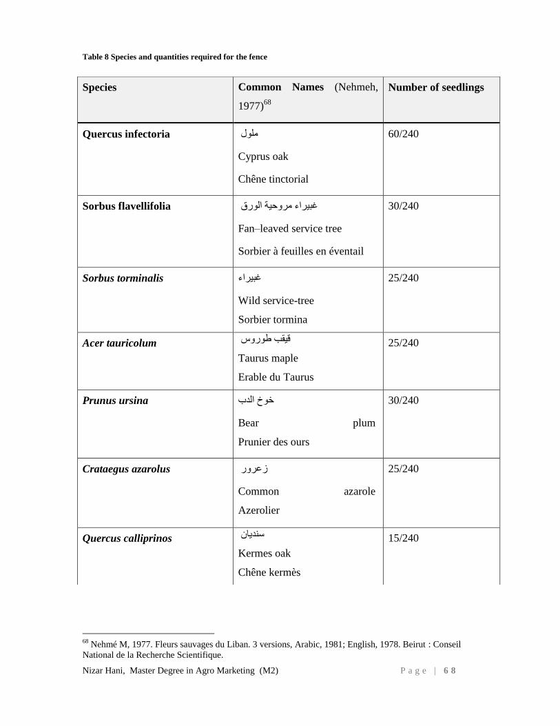
Nizar Hani, Master Degree in Agro Marketing (M2) P a g e | 6 8
Table 8 Species and quantities required for the fence
68
Nehmé M, 1977. Fleurs sauvages du Liban. 3 versions, Arabic, 1981; English, 1978. Beirut : Conseil
National de la Recherche Scientifique.
Species Common Names (Nehmeh,
1977)68
Number of seedlings
Quercus infectoria ملول
Cyprus oak
Chêne tinctorial
60/240
Sorbus flavellifolia غبيراء مروحية الورق
Fan–leaved service tree
Sorbier à feuilles en éventail
30/240
Sorbus torminalis غبيراء
Wild service-tree
Sorbier tormina
25/240
Acer tauricolum قيقب طوروس
Taurus maple
Erable du Taurus
25/240
Prunus ursina خوخ الدب
Bear plum
Prunier des ours
30/240
Crataegus azarolus زعرور
Common azarole
Azerolier
25/240
Quercus calliprinos سنديان
Kermes oak
Chêne kermès
15/240
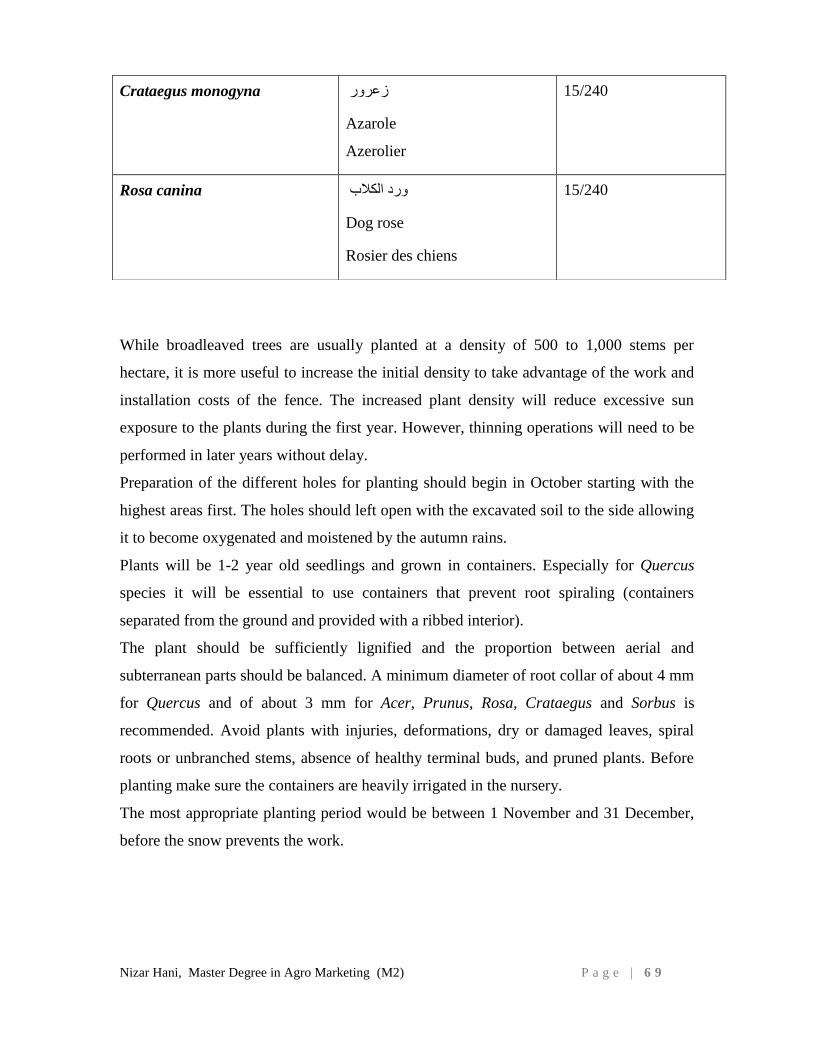
Nizar Hani, Master Degree in Agro Marketing (M2) P a g e | 6 9
While broadleaved trees are usually planted at a density of 500 to 1,000 stems per
hectare, it is more useful to increase the initial density to take advantage of the work and
installation costs of the fence. The increased plant density will reduce excessive sun
exposure to the plants during the first year. However, thinning operations will need to be
performed in later years without delay.
Preparation of the different holes for planting should begin in October starting with the
highest areas first. The holes should left open with the excavated soil to the side allowing
it to become oxygenated and moistened by the autumn rains.
Plants will be 1-2 year old seedlings and grown in containers. Especially for Quercus
species it will be essential to use containers that prevent root spiraling (containers
separated from the ground and provided with a ribbed interior).
The plant should be sufficiently lignified and the proportion between aerial and
subterranean parts should be balanced. A minimum diameter of root collar of about 4 mm
for Quercus and of about 3 mm for Acer, Prunus, Rosa, Crataegus and Sorbus is
recommended. Avoid plants with injuries, deformations, dry or damaged leaves, spiral
roots or unbranched stems, absence of healthy terminal buds, and pruned plants. Before
planting make sure the containers are heavily irrigated in the nursery.
The most appropriate planting period would be between 1 November and 31 December,
before the snow prevents the work.
Crataegus monogyna زعرور
Azarole
Azerolier
15/240
Rosa canina ورد الكالب
Dog rose
Rosier des chiens
15/240
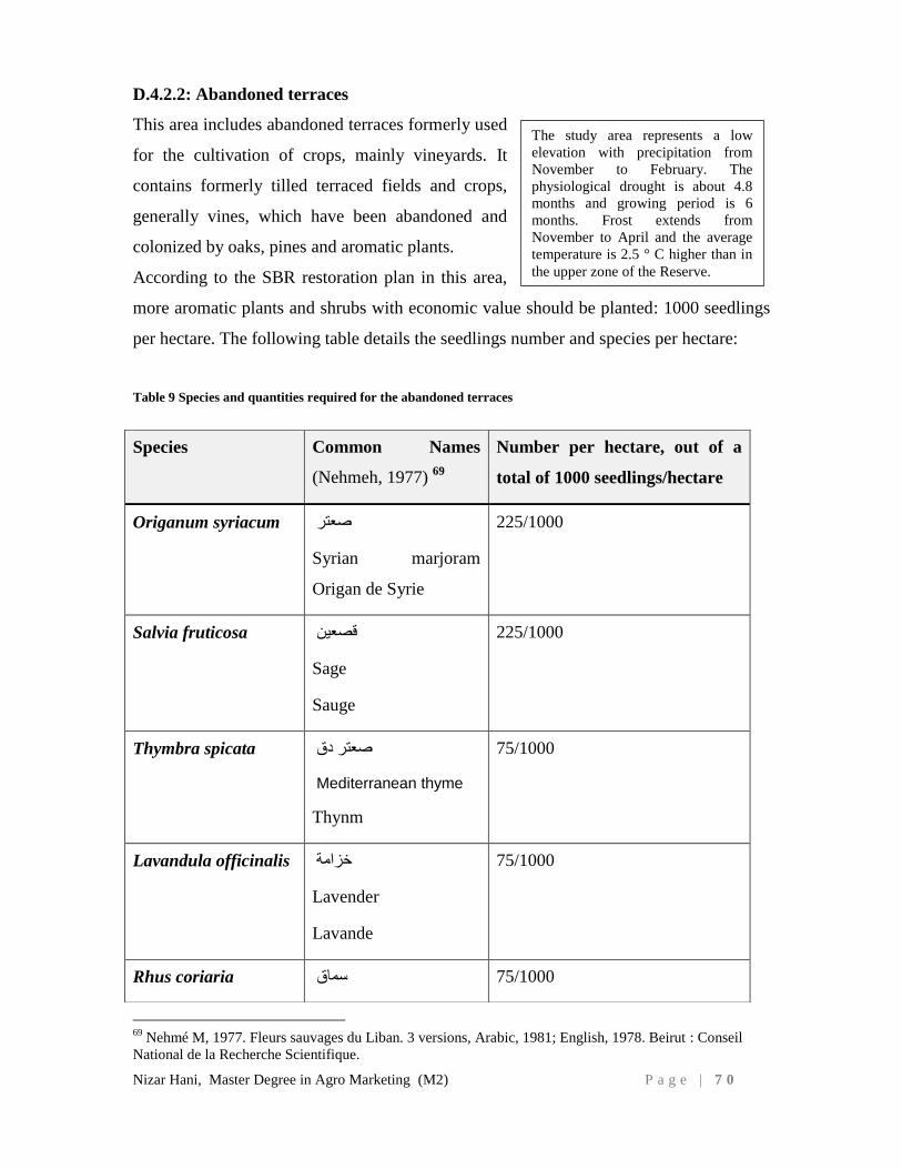
Nizar Hani, Master Degree in Agro Marketing (M2) P a g e | 7 0
D.4.2.2: Abandoned terraces
This area includes abandoned terraces formerly used
for the cultivation of crops, mainly vineyards. It
contains formerly tilled terraced fields and crops,
generally vines, which have been abandoned and
colonized by oaks, pines and aromatic plants.
According to the SBR restoration plan in this area,
more aromatic plants and shrubs with economic value should be planted: 1000 seedlings
per hectare. The following table details the seedlings number and species per hectare:
Table 9 Species and quantities required for the abandoned terraces
69
Nehmé M, 1977. Fleurs sauvages du Liban. 3 versions, Arabic, 1981; English, 1978. Beirut : Conseil
National de la Recherche Scientifique.
Species Common Names
(Nehmeh, 1977) 69
Number per hectare, out of a
total of 1000 seedlings/hectare
Origanum syriacum
صعتر
Syrian marjoram
Origan de Syrie
225/1000
Salvia fruticosa قصعين
Sage
Sauge
225/1000
Thymbra spicata صعتر دق
Mediterranean thyme
Thynm
75/1000
Lavandula officinalis خزامة
Lavender
Lavande
75/1000
Rhus coriaria 75/1000 سماق
The study area represents a low
elevation with precipitation from
November to February. The
physiological drought is about 4.8
months and growing period is 6
months. Frost extends from
November to April and the average
temperature is 2.5 ° C higher than in
the upper zone of the Reserve.
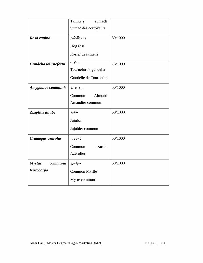
Nizar Hani, Master Degree in Agro Marketing (M2) P a g e | 7 1
Tannerʼs sumach
Sumac des corroyeurs
Rosa canina ورد الكالب
Dog rose
Rosier des chiens
50/1000
Gundelia tournefortii عكوب
Tournefort’s gundelia
Gundélie de Tournefort
75/1000
Amygdalus communis
لوز بري
Common Almond
Amandier commun
50/1000
Ziziphus jujube عناب
Jujuba
Jujubier commun
50/1000
Crataegus azarolus
زعرور
Common azarole
Azerolier
50/1000
Myrtus communis
leucocarpa
حنبالس
Common Myrtle
Myrte commun
50/1000
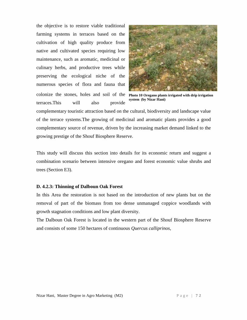
Nizar Hani, Master Degree in Agro Marketing (M2) P a g e | 7 2
the objective is to restore viable traditional
farming systems in terraces based on the
cultivation of high quality produce from
native and cultivated species requiring low
maintenance, such as aromatic, medicinal or
culinary herbs, and productive trees while
preserving the ecological niche of the
numerous species of flora and fauna that
colonize the stones, holes and soil of the
terraces.This will also provide
complementary touristic attraction based on the cultural, biodiversity and landscape value
of the terrace systems.The growing of medicinal and aromatic plants provides a good
complementary source of revenue, driven by the increasing market demand linked to the
growing prestige of the Shouf Biosphere Reserve.
This study will discuss this section into details for its economic return and suggest a
combination scenario between intensive oregano and forest economic value shrubs and
trees (Section E3).
D. 4.2.3: Thinning of Dalboun Oak Forest
In this Area the restoration is not based on the introduction of new plants but on the
removal of part of the biomass from too dense unmanaged coppice woodlands with
growth stagnation conditions and low plant diversity.
The Dalboun Oak Forest is located in the western part of the Shouf Biosphere Reserve
and consists of some 150 hectares of continuous Quercus calliprinos,
Photo 10 Oregano plants irrigated with drip irrigation
system (by Nizar Hani)
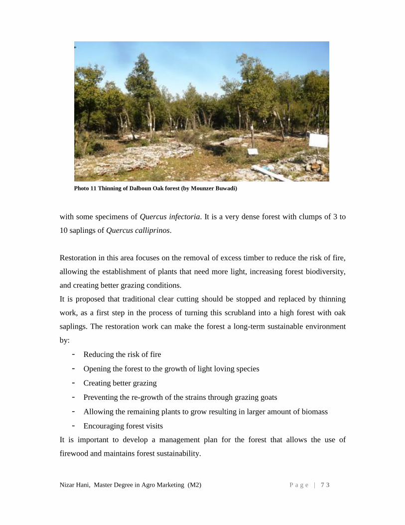
Nizar Hani, Master Degree in Agro Marketing (M2) P a g e | 7 3
with some specimens of Quercus infectoria. It is a very dense forest with clumps of 3 to
10 saplings of Quercus calliprinos.
Restoration in this area focuses on the removal of excess timber to reduce the risk of fire,
allowing the establishment of plants that need more light, increasing forest biodiversity,
and creating better grazing conditions.
It is proposed that traditional clear cutting should be stopped and replaced by thinning
work, as a first step in the process of turning this scrubland into a high forest with oak
saplings. The restoration work can make the forest a long-term sustainable environment
by:
- Reducing the risk of fire
- Opening the forest to the growth of light loving species
- Creating better grazing
- Preventing the re-growth of the strains through grazing goats
- Allowing the remaining plants to grow resulting in larger amount of biomass
- Encouraging forest visits
It is important to develop a management plan for the forest that allows the use of
firewood and maintains forest sustainability.
Photo 11 Thinning of Dalboun Oak forest (by Mounzer Buwadi)
Nizar Hani, Master Degree in Agro Marketing (M2) P a g e | 7 4
D.4.3: Improvement Scenario for agricultural land mainly apple and vegetables
The objective of this scenario is to improve the traditional agriculture land to be more
productive with better quality and less impact on nature.
Based on the needs that highlighted by the farmers in the situation analysis section of the
agriculture in the region we recommend the following:
Build the capacities of the farmers on good and sustainable agricultural practices:
integrated pest management, conservation agriculture and organic agriculture
when possible
Strengthen the 4 existing cooperatives on the administrative and technical levels
Introduce the cultivation of inter-cropping such as edible and aromatic plants in
the traditional fruit orchards to increase the revenue per unit surface area. The
suggested aromatic plants are oreganum syriacum, salvia triloba, and lavandula
officinalis, among others
Build the capacities of the farmers on appropriate harvesting and post-harvesting
practices. This could include the introduction of new tools, equipment and
materials such as pruning shears, refrigerated trucks, special gloves for
harvesting, smooth edges field containers, etc
Enhance the existing infrastructure mainly establishing a small packaging house
in each village mainly Barouk, Ain Zhalta and Mrusti, establish a market for
farmers nearby Beirut, establish more hill lakes to collect rain water.
Plant new varieties of fruit trees mainly apple using certified rootstocks which are
virus free, drought tolerant and of good varietal quality. Improve marketing
opportunities by seeking better marketing channels and by overcoming the role of
the middlemen or by improving their ability to negotiate better contracts with
middlemen
Initiate and support organic agriculture with key farmers
Enhance the processing food business in the region on small industrial scale by
establishing processing units or build on existing cooperative and community
kitchens
Nizar Hani, Master Degree in Agro Marketing (M2) P a g e | 7 5
Strengthen the organization of farmers and processors to work as a group (formal
or informal groups) and establish a network of the existing cooperatives to have
better linkages and negotiating power with public and private institutions.
D.4.4: Beautification Scenario for vacant residential / built areas
Parks and Natural green spaces70
are essential elements of our cities and the ecosystem
they belong to. The World Health Organization (WHO) and Food and Agriculture
Organization (FAO) have set a minimum of 9 m2 green space per inhabitant
(Kuchelmeister G., 1998)71
. Required green space per capita in cities is an emerging
policy, and design concept. The benefits of green space comprise climate change
mitigation, health benefits and a diverse array of physical and socio-cultural activities,
green space provides social support to communities (Barbosa O., 2007)72
. Parks and
natural green spaces can be used for recreation; water bodies and forests supply storm-
water drainage and wildlife habitat; farms and forests provide aesthetic benefits to
surrounding residents.
The vacant areas in the villages are owned by the municipalities and individuals, the
areas that owned by municipalities can be transformed to picnic areas that will be a green
spaces for the local communities as well as the visitors to the region.
We proposed to restore these vacant areas by planting several shrubs and plant species
such as cedrus libani, pinus pinea, populus alba, Quercus calliprinos, styrax officinalis,
cercis siliquastrum, Rosa canina, Crataegus azarolus, Rhus coriaria, Lavandula
officinalis, Origanum syriacum, rosmarinus officinalis, etc.
The density of planting is 900-1000 seedlings per hectare.
70
Green space includes all types of accessible vegetated public lands. Three main components of green
space are more or less common across the reviewed literature: patch (public parks or gardens and forest
patches), corridor (linear parks and street planting) and network arrangement (a layout system connecting
all patches and corridors)
71
Kuchelmeister Guido, “Urban forestry in the Asia-Pacific region: status and prospects” Forestry Policy
and Planning Divison, Rome and Regional Office for Asia and the Pacific, Bangkok, 1998. 5.1-5.1.7Laurif,
2000.
72
Barbosa O., “Who benefits from access to green space? A case study from Sheffield, UK,” Landscape
and Urban Planning 83 (2007): 187-195
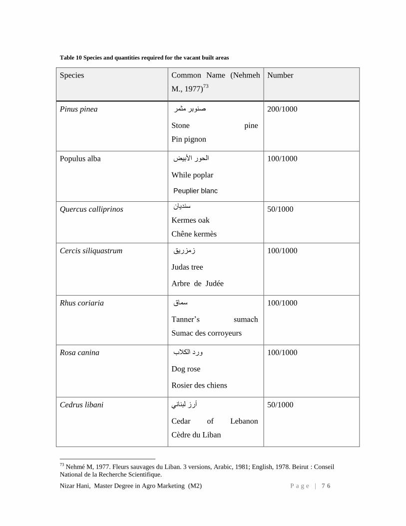
Nizar Hani, Master Degree in Agro Marketing (M2) P a g e | 7 6
Table 10 Species and quantities required for the vacant built areas
Species Common Name (Nehmeh
M., 1977)73
Number
Pinus pinea
صنوبر مثمر
Stone pine
Pin pignon
200/1000
Populus alba الحور األبيض
While poplar
Peuplier blanc
100/1000
Quercus calliprinos سنديان
Kermes oak
Chêne kermès
50/1000
Cercis siliquastrum زمزريق
Judas tree
Arbre de Judée
100/1000
Rhus coriaria سماق
Tannerʼs sumach
Sumac des corroyeurs
100/1000
Rosa canina ورد الكالب
Dog rose
Rosier des chiens
100/1000
Cedrus libani أرز لبناني
Cedar of Lebanon
Cèdre du Liban
50/1000
73
Nehmé M, 1977. Fleurs sauvages du Liban. 3 versions, Arabic, 1981; English, 1978. Beirut : Conseil
National de la Recherche Scientifique.
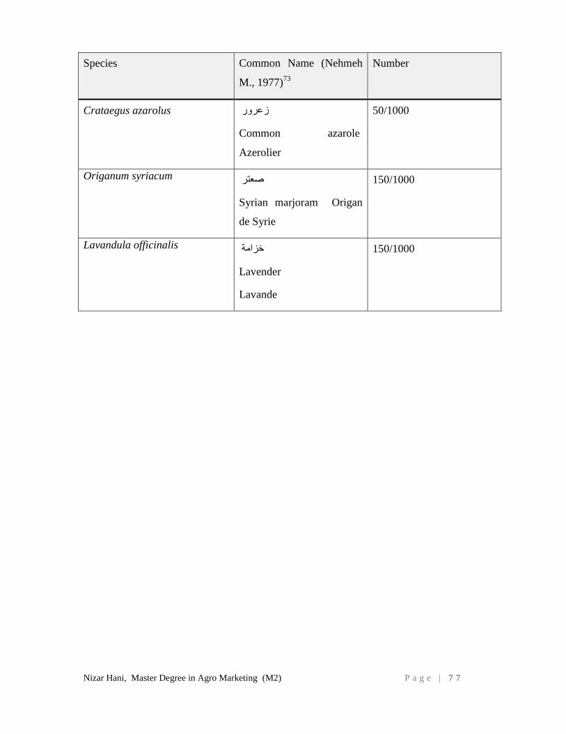
Nizar Hani, Master Degree in Agro Marketing (M2) P a g e | 7 7
Species Common Name (Nehmeh
M., 1977)73
Number
Crataegus azarolus زعرور
Common azarole
Azerolier
50/1000
Origanum syriacum صعتر
Syrian marjoram Origan
de Syrie
150/1000
Lavandula officinalis خزامة
Lavender
Lavande
150/1000
Nizar Hani, Master Degree in Agro Marketing (M2) P a g e | 7 8
D.4. PROBLEMATIC
The ecosystem in the Shouf Biosphere Reserve (SBR), the buffer and development zones
is susceptible for degradation on both ecological and physical levels, mainly the old
abandoned terraces. This abandoned land will have subsequent negative environmental
impact and reduced economic return.
D.5. MAIN OBJECTIVE
The main objective is to assess the socio-economic of the ecosystem restoration with a
focus on abandoned terraces by rehabilitating and transforming it into an income
generating agriculture activity.
D.6. METHODOLOGY:
The study consists a series of interviews with the concerned key persons in the region,
mainly presidents of the agriculture cooperatives, farmers, Shouf Biosphere Reserve
president and management team, the coordinator and team of the agriculture extension
center in Deir El kamar, Mayors of Barouk, Maasser, Ain Zhalta, Mrusti, the teachers of
the agriculture school in Baakleen, oak forest thinning workers, concerned NGOs such as
Al-Shouf Cedar Society (ACS) Green Hand, Association for Forest Conservation and
Development (AFDC), quality control companies, a creative designer, couple of
international consultants in the ecosystem restoration and fog catchers. A list of the key
persons interviewed is annexed (Annex I)
The interviews with the cooperatives discussed the agriculture sector in the region in
general, identified the weaknesses and strengths of the domain mainly the marketing.
With the farmers the interviews focused on the used practices, using pesticides, their
knowledge about organic agriculture, difficulties, market, etc.
While the focus with the agriculture extension center in Deir el Kamar was about
statistics, number of farmers in the study area, surfaces, number of active cooperatives,
the support that MOA provides to the farmers, training, traps, pesticides, materials, etc.
Nizar Hani, Master Degree in Agro Marketing (M2) P a g e | 7 9
The mayors were more interested in the market and the labeling, the Barouk mayor
stressed on the importance of creating one label for the region to promote the fresh goods
while the Maasser Mayor (president of the SBR) expressed his concern of thinning the
oak forests. Despite the economic value of thinning the oak forest and its role in
prevention of fire, his main concern is that will harm the beauty of the landscape.
The international Spanish consultants who interviewed focused on the big potential to
this region to be a success story in ecosystem restoration and that will enhance the quality
of life in this region on all levels and will give this region more international good
reputation in nature conservation and integration with local community development.
The restoration plan of the SBR reviewed and discussed mainly the below two scenarios
1. Restoration Scenario for protected land in the core area of the Shouf
Biosphere Reserve
2. Restoration Scenario for abandoned terraces land which is mostly privately
owned
Also two other scenarios have been conducted in the framework on this study:
3. Improvement Scenario for agricultural land mainly apple and vegetables
4. Beautification Scenario for vacant residential / built areas
As well as many field visits were organized to visit the different related sites and
facilities in the study area (reforestation sites in the Reserve, agricultural lands, aromatic
plants initiatives mainly Origanum syriacum, cooling room in Barouk village, point of
sales, Souk El Tayeb, traditional product ateliers, and natural food coop in USA..
In addition, secondary data sources and desk studies were reviewed, relevant articles,
reports, management plans, action plans, movies, documentaries, studies, on the local,
regional and international levels.
As for land use type and corresponding surface areas, we relied on two sources:
Nizar Hani, Master Degree in Agro Marketing (M2) P a g e | 8 0
1- Secondary data source: MOA/FAO agriculture statistic (FAO-MOA,
2012)74
, survey validated by Deir el Kamar extension center MOA to
validate the MOA/FAO statistics on the ground, the latter survey adjusted
the types and surface area and the following was noted: peach orchards
were identified as one of the agriculture type also summer crops mainly
tomatoes were identified as an agriculture although on a small scale.
2- As for actual surface area considered in this study, it is 901 ha, where only
70% is considered in the study equivalent to approximately 600 ha. It
relies as detailed in section C.1 (Description of the study area) on the land
use map for arable agriculture land (Table 5,:MOE, 1997) and on the
areas currently cultivated according to the statistics (FAO-MOA, 2012).
Based on the preliminary, secondary data and the experience in the study area and the
data collected from the interviews, a situation analysis was conducted to identify all
relevant key actors and identify the role of each of them and their concerns. The analysis
also covers the weaknesses and strengths of the agriculture sector in the study area.
Based on all results, the four scenarios of ecosystem restoration described in section 4,
two scenarios are analyzed and discussed for this study (taken from Scenario 1-2,
Colomer R. et al, 201375
). The present study suggests a combination of 4 scenarios that
are sustainable to the SBR ecosystems taking into consideration the agriculture and built
areas.
Furthermore, in this study each scenario different interventions are discussed. As for
scenario 2 “the abandoned terraces”, two different options are proposed to restore the
abandoned terraces through a profitable agriculture action while preserving the ecosystem
also a cost benefit analysis and net present value are conducted for added value crops
including a marketing strategy and action plan.
74
MOA-FAO, 2012. The national agriculture survey.
75
Colomer R., Regato P., 2013. Shouf Biosphere Reserve Ecosystem Restoration Plan. Pages 24-41
Nizar Hani, Master Degree in Agro Marketing (M2) P a g e | 8 1
E. SITUATION ANALYSIS
E.1. ACTORS AND STAKEHOLDERS
A considerable number of actors are playing an important role in the agriculture sector in
the study area. These actors are important and relevant players at the local, national, or
international levels. Many of them have been involved in the consultation process carried
out during the development phase of this thesis, and have provided their input and
feedback. These stakeholders are set to play a potentially important role in the future to
enhance the ecosystem situation mainly agriculture sector in the study area, on different
levels technical and/or financial assistance, decision makers, beneficiaries, etc.
Local stakeholders:
- Municipalities of the study area (9 municipalities)
- Federation of Municipalities of the Higher Shouf (Moukhtara)
- Agriculture cooperatives (Barouk, Batloun and Mrusti)
- Shouf Biosphere Reserve
- Ministry of agriculture – Deir El Kamar extension center
- Al-Shouf Cedar Society
- Ministry of agriculture - Agriculture technical school in Baakline
- Local Environmental NGOs: Green Orient, Friends of Green Environment, the
Lebanese Home for the Environment
- Small and medium entrepreneurs in the rural economy sector: beekeepers,
farmers, shepherds, collectors
- Agriculture-related enterprises
- Private sector and providers of tourism-related services: restaurants (20
stakeholders); guesthouse owners (7 stakeholders); hotel and hostel owners (4
stakeholders); shop owners (40 stakeholders)
- Private Land Owners
- Local Schools and education associations
Nizar Hani, Master Degree in Agro Marketing (M2) P a g e | 8 2
National stakeholders:
- Ministry of agriculture
- Lebanese research agriculture center (LARI) in Lebanon
- Lebanese Ministry of Environment
- Universities in Lebanon (AUB, LU, etc)
- The Environment and Sustainable Development Unit at AUB (ESDU)
- National NGOs: arcenciel, Souk el Tayeb, etc.
- Quality certification bodies such as Liban cert (stopped their work in 2014) and
IMC.
- Lebanese alternative agriculture experts
- Lebanese Media (TV, radio, press)
International and regional stakeholders:
- IUCN particularly Regional Offices for West Asia and Mediterranean regions
- International UN Organizations: UNEP, UNDP, FAO, IFAD, UNESCO, etc
- International universities, researchers and technicians
- Members of the Donor community active in Lebanon: Italian Cooperation, GIZ,
USAID, SDC, AFD, European Commission
- Embassies of Donor Countries (Japan, USA, Finland, Canada etc.)
- Private donors such Rotary Club, lions, etc
Nizar Hani, Master Degree in Agro Marketing (M2) P a g e | 8 3
E.2. STRENGTHS AND WEAKNESSES OF THE AGRICULTURE
SECTOR:
Based on the interviews that have been done with agriculture stakeholders in the study
area the current situation of the agriculture is as follow:
Weaknesses:
Issues related directly to farmers:
Lack of knowledge, capacities and skills of most of the farmers
Lack of cooperative mentality, they don’t collect their goods together to get better
price and the existing agriculture cooperatives need support on all levels
Lack of transparency with some farmers (the MOA distribute some materials
mainly medicines for beekeeping, traps, etc and sometimes the team of the
agriculture extension center in Deir El Kamar finds those materials are selling at
the agriculture pharmacies in the region)
Farmers are not so open to use new varieties, technologies, methods, etc
The farmers are not so honest in using pesticides, pruning practices, new
technologies, methods, etc
Lack of equipment and machineries (for example 3 workers can collect manually
200-250 kg of olives per day while if they have a harvesting machine they will
collect 500 kg at least) and to minimize harvest and packing damage such as
special gloves for harvesting, smooth edges field containers, etc.
Lack of infrastructure (no packing house, no cool trucks in the villages, one
cooling private room in Barouk village, water drip irrigation, etc).
Issues related to Market:
The market is so limited mainly after the Syria crises, the goods sell at the local
market
A big quantity of the olive oil of the last year still not sold because they did not
reach a good agreement to sell to the army
Reliance on middlemen/ mediators to reach the wholesale market
No marketing strategy as well as no branding, labeling, etc.
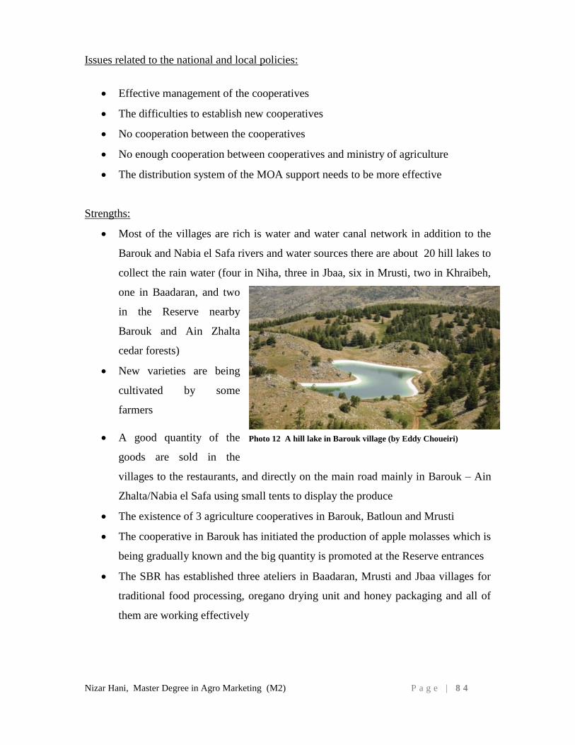
Nizar Hani, Master Degree in Agro Marketing (M2) P a g e | 8 4
Issues related to the national and local policies:
Effective management of the cooperatives
The difficulties to establish new cooperatives
No cooperation between the cooperatives
No enough cooperation between cooperatives and ministry of agriculture
The distribution system of the MOA support needs to be more effective
Strengths:
Most of the villages are rich is water and water canal network in addition to the
Barouk and Nabia el Safa rivers and water sources there are about 20 hill lakes to
collect the rain water (four in Niha, three in Jbaa, six in Mrusti, two in Khraibeh,
one in Baadaran, and two
in the Reserve nearby
Barouk and Ain Zhalta
cedar forests)
New varieties are being
cultivated by some
farmers
A good quantity of the
goods are sold in the
villages to the restaurants, and directly on the main road mainly in Barouk – Ain
Zhalta/Nabia el Safa using small tents to display the produce
The existence of 3 agriculture cooperatives in Barouk, Batloun and Mrusti
The cooperative in Barouk has initiated the production of apple molasses which is
being gradually known and the big quantity is promoted at the Reserve entrances
The SBR has established three ateliers in Baadaran, Mrusti and Jbaa villages for
traditional food processing, oregano drying unit and honey packaging and all of
them are working effectively
Photo 12 A hill lake in Barouk village (by Eddy Choueiri)
Nizar Hani, Master Degree in Agro Marketing (M2) P a g e | 8 5
The villages involve actively in the processing food program (Rural development
program) managed by the Al-Shouf Cedar Society; more than 70 processing food
products are produced, labeled, and promoted in and outside Lebanon.
Barouk is one hour drive from Beirut, hence not very far from the wholesale
market of Beirut.
About 62,000 visitors visit the Reserve on yearly basis through four entrances:
Ain Zhalta, Barouk, Maasser, Niha and this year a new entrance will be
established in Mrusti village
Big potential of planting new species, medicinal and aromatic plants in the
abandoned terraces that mentioned above
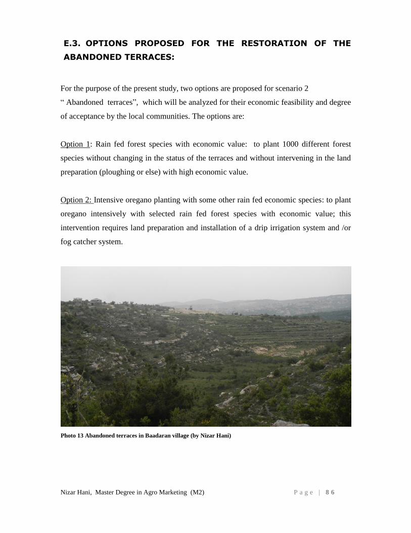
Nizar Hani, Master Degree in Agro Marketing (M2) P a g e | 8 6
E.3. OPTIONS PROPOSED FOR THE RESTORATION OF THE
ABANDONED TERRACES:
For the purpose of the present study, two options are proposed for scenario 2
“ Abandoned terraces”, which will be analyzed for their economic feasibility and degree
of acceptance by the local communities. The options are:
Option 1: Rain fed forest species with economic value: to plant 1000 different forest
species without changing in the status of the terraces and without intervening in the land
preparation (ploughing or else) with high economic value.
Option 2: Intensive oregano planting with some other rain fed economic species: to plant
oregano intensively with selected rain fed forest species with economic value; this
intervention requires land preparation and installation of a drip irrigation system and /or
fog catcher system.
Photo 13 Abandoned terraces in Baadaran village (by Nizar Hani)
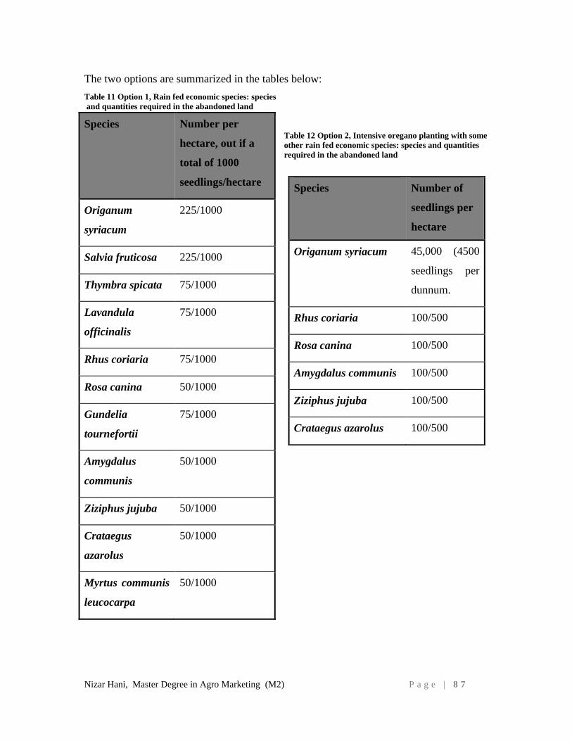
Nizar Hani, Master Degree in Agro Marketing (M2) P a g e | 8 7
The two options are summarized in the tables below:
Table 11 Option 1, Rain fed economic species: species
and quantities required in the abandoned land
Table 12 Option 2, Intensive oregano planting with some
other rain fed economic species: species and quantities
required in the abandoned land
Species Number per
hectare, out if a
total of 1000
seedlings/hectare
Origanum
syriacum
225/1000
Salvia fruticosa 225/1000
Thymbra spicata 75/1000
Lavandula
officinalis
75/1000
Rhus coriaria 75/1000
Rosa canina 50/1000
Gundelia
tournefortii
75/1000
Amygdalus
communis
50/1000
Ziziphus jujuba 50/1000
Crataegus
azarolus
50/1000
Myrtus communis
leucocarpa
50/1000
Species Number of
seedlings per
hectare
Origanum syriacum 45,000 (4500
seedlings per
dunnum.
Rhus coriaria 100/500
Rosa canina 100/500
Amygdalus communis 100/500
Ziziphus jujuba 100/500
Crataegus azarolus 100/500
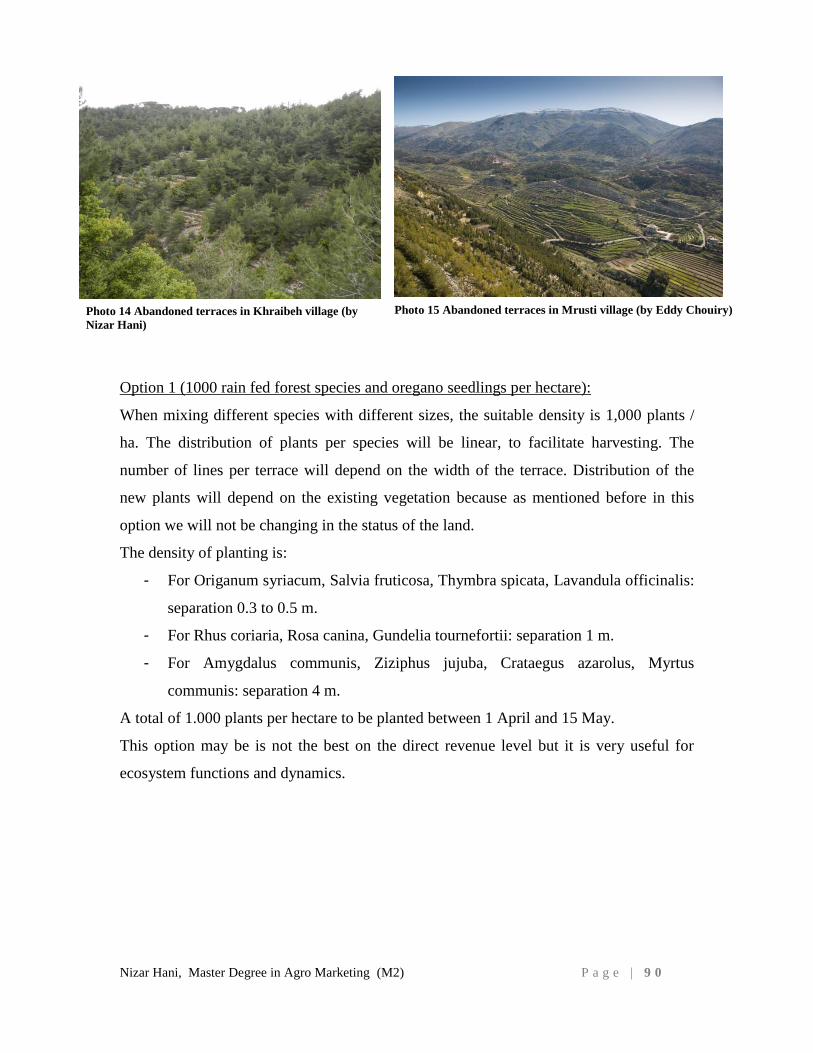
Nizar Hani, Master Degree in Agro Marketing (M2) P a g e | 9 0
Option 1 (1000 rain fed forest species and oregano seedlings per hectare):
When mixing different species with different sizes, the suitable density is 1,000 plants /
ha. The distribution of plants per species will be linear, to facilitate harvesting. The
number of lines per terrace will depend on the width of the terrace. Distribution of the
new plants will depend on the existing vegetation because as mentioned before in this
option we will not be changing in the status of the land.
The density of planting is:
- For Origanum syriacum, Salvia fruticosa, Thymbra spicata, Lavandula officinalis:
separation 0.3 to 0.5 m.
- For Rhus coriaria, Rosa canina, Gundelia tournefortii: separation 1 m.
- For Amygdalus communis, Ziziphus jujuba, Crataegus azarolus, Myrtus
communis: separation 4 m.
A total of 1.000 plants per hectare to be planted between 1 April and 15 May.
This option may be is not the best on the direct revenue level but it is very useful for
ecosystem functions and dynamics.
Photo 15 Abandoned terraces in Mrusti village (by Eddy Chouiry) Photo 14 Abandoned terraces in Khraibeh village (by
Nizar Hani)

Nizar Hani, Master Degree in Agro Marketing (M2) P a g e | 9 1
Option 2 (500 rain fed forest seedlings and 45000 oregano seedlings per hectare):
The terraces will be cleaned from weeds, and
rocks, the stone wall will be restored. The land
will be planted intensively with Oregano
seedlings, 40 cm spacing between seedlings and
50 cm between rows and the other 500 native
shrub seedlings will be distributed on the edges of
the terraces 2-3 m apart. to avoid shading on the
oregano and not to harm the movement of the
farmers in the land.
For this option and for the proper growth and
rooting of plants in these terraces, drip irrigation
system will be installed. It includes the installation of header tank and a main and
secondary network of dripper hose. The water will be provided from different sources,
water sources and /or hill lakes and /or fog catchers.
The condensation panels or fog catchers are recommended to be installed. Fog catchers
have been used for years in Europe to irrigate areas of low rainfall. This technique
consists of placing low-cost panels in order to condensate the fog in specific areas and
then using its water to irrigate plants. Fog is common feature in the Shouf Biosphere
Reserve especially during the early hours of the day because of its proximity to the sea
and high altitude slopes that face the sea coast.
Multiple screens and fog catchers can be placed in the abandoned terraces to collect the
water during the early hours of the day, especially in summer. This condensed water will
be used to fill a number of water tanks that will supply the drip irrigation system.
These fog catchers have been tested in many countries mainly South Africa, Chile, Peru
as well as Yemen, Oman and present a high potential of adaptability to our context, the
FogQuest is a non-profit, registered Canadian charity dedicated to planning and
implementing water projects for rural communities in developing countries.
FogQuest utilizes innovative fog collectors as well as effective rainfall collectors
to make optimum use of natural atmospheric sources of water. Both options can be
used to ensure enough income for the farmers and healthy ecosystems for the
environment.
Fog Catchers are vertical panels of
polyethylene mesh that collect water from
fog and channel it to a storage tank
http://wateradvocate.org/fogcatcher.htm
Photo 16 Fog catcher in a rural area in Chile (by
FogQuest)
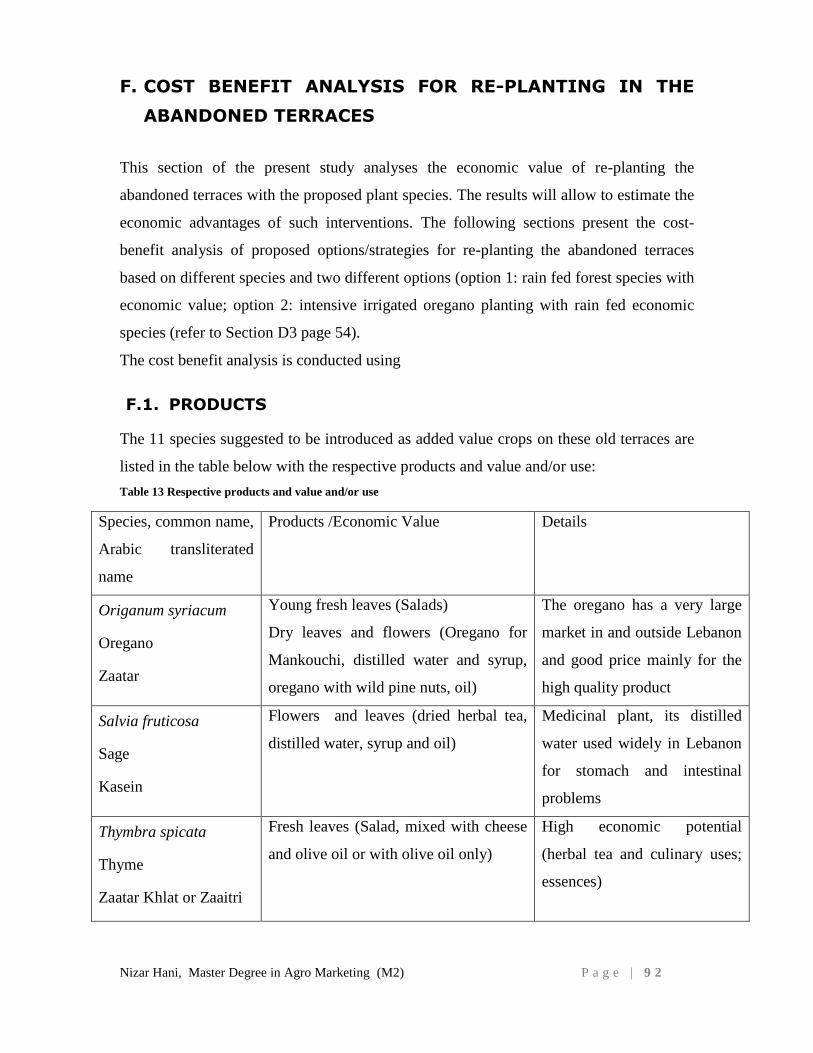
Nizar Hani, Master Degree in Agro Marketing (M2) P a g e | 9 2
F. COST BENEFIT ANALYSIS FOR RE-PLANTING IN THE
ABANDONED TERRACES
This section of the present study analyses the economic value of re-planting the
abandoned terraces with the proposed plant species. The results will allow to estimate the
economic advantages of such interventions. The following sections present the cost-
benefit analysis of proposed options/strategies for re-planting the abandoned terraces
based on different species and two different options (option 1: rain fed forest species with
economic value; option 2: intensive irrigated oregano planting with rain fed economic
species (refer to Section D3 page 54).
The cost benefit analysis is conducted using
F.1. PRODUCTS
The 11 species suggested to be introduced as added value crops on these old terraces are
listed in the table below with the respective products and value and/or use:
Table 13 Respective products and value and/or use
Species, common name,
Arabic transliterated
name
Products /Economic Value Details
Origanum syriacum
Oregano
Zaatar
Young fresh leaves (Salads)
Dry leaves and flowers (Oregano for
Mankouchi, distilled water and syrup,
oregano with wild pine nuts, oil)
The oregano has a very large
market in and outside Lebanon
and good price mainly for the
high quality product
Salvia fruticosa
Sage
Kasein
Flowers and leaves (dried herbal tea,
distilled water, syrup and oil)
Medicinal plant, its distilled
water used widely in Lebanon
for stomach and intestinal
problems
Thymbra spicata
Thyme
Zaatar Khlat or Zaaitri
Fresh leaves (Salad, mixed with cheese
and olive oil or with olive oil only)
High economic potential
(herbal tea and culinary uses;
essences)
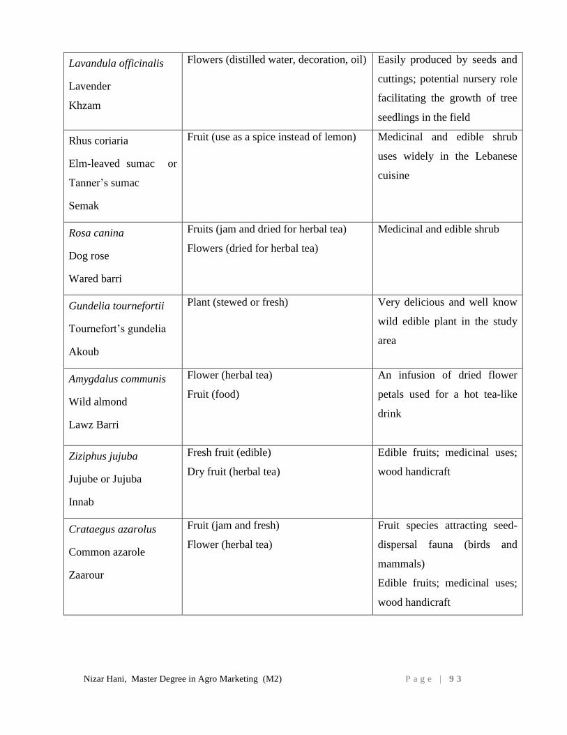
Nizar Hani, Master Degree in Agro Marketing (M2) P a g e | 9 3
Lavandula officinalis
Lavender
Khzam
Flowers (distilled water, decoration, oil) Easily produced by seeds and
cuttings; potential nursery role
facilitating the growth of tree
seedlings in the field
Rhus coriaria
Elm-leaved sumac or
Tanner’s sumac
Semak
Fruit (use as a spice instead of lemon) Medicinal and edible shrub
uses widely in the Lebanese
cuisine
Rosa canina
Dog rose
Wared barri
Fruits (jam and dried for herbal tea)
Flowers (dried for herbal tea)
Medicinal and edible shrub
Gundelia tournefortii
Tournefort’s gundelia
Akoub
Plant (stewed or fresh) Very delicious and well know
wild edible plant in the study
area
Amygdalus communis
Wild almond
Lawz Barri
Flower (herbal tea)
Fruit (food)
An infusion of dried flower
petals used for a hot tea-like
drink
Ziziphus jujuba
Jujube or Jujuba
Innab
Fresh fruit (edible)
Dry fruit (herbal tea)
Edible fruits; medicinal uses;
wood handicraft
Crataegus azarolus
Common azarole
Zaarour
Fruit (jam and fresh)
Flower (herbal tea)
Fruit species attracting seed-
dispersal fauna (birds and
mammals)
Edible fruits; medicinal uses;
wood handicraft
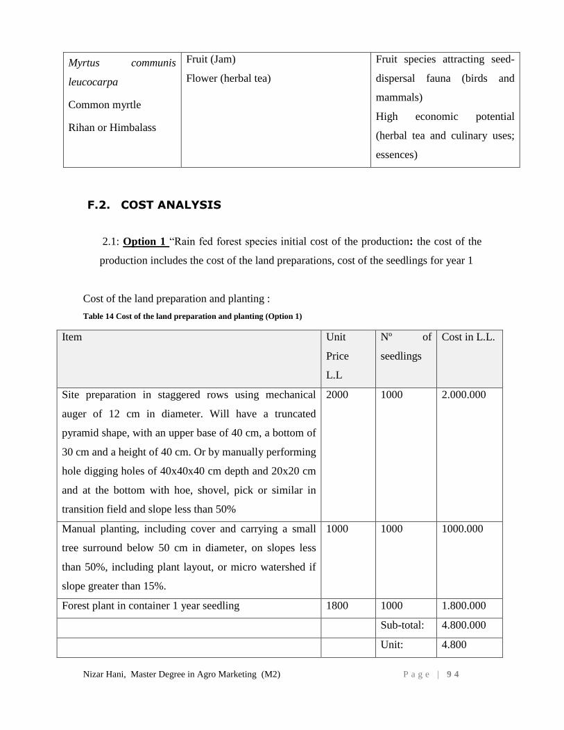
Nizar Hani, Master Degree in Agro Marketing (M2) P a g e | 9 4
Myrtus communis
leucocarpa
Common myrtle
Rihan or Himbalass
Fruit (Jam)
Flower (herbal tea)
Fruit species attracting seed-
dispersal fauna (birds and
mammals)
High economic potential
(herbal tea and culinary uses;
essences)
F.2. COST ANALYSIS
2.1: Option 1 “Rain fed forest species initial cost of the production: the cost of the
production includes the cost of the land preparations, cost of the seedlings for year 1
Cost of the land preparation and planting :
Table 14 Cost of the land preparation and planting (Option 1)
Item Unit
Price
L.L
Nº of
seedlings
Cost in L.L.
Site preparation in staggered rows using mechanical
auger of 12 cm in diameter. Will have a truncated
pyramid shape, with an upper base of 40 cm, a bottom of
30 cm and a height of 40 cm. Or by manually performing
hole digging holes of 40x40x40 cm depth and 20x20 cm
and at the bottom with hoe, shovel, pick or similar in
transition field and slope less than 50%
2000 1000 2.000.000
Manual planting, including cover and carrying a small
tree surround below 50 cm in diameter, on slopes less
than 50%, including plant layout, or micro watershed if
slope greater than 15%.
1000 1000 1000.000
Forest plant in container 1 year seedling 1800 1000 1.800.000
Sub-total: 4.800.000
Unit: 4.800
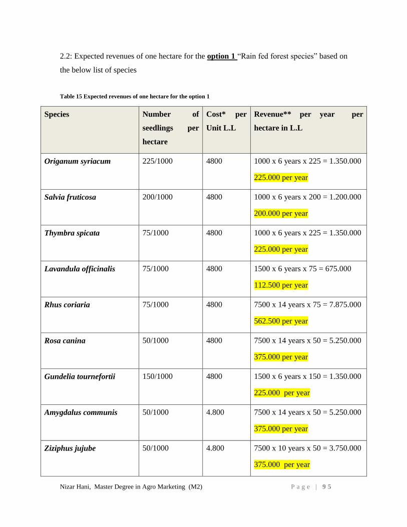
Nizar Hani, Master Degree in Agro Marketing (M2) P a g e | 9 5
2.2: Expected revenues of one hectare for the option 1 “Rain fed forest species” based on
the below list of species
Table 15 Expected revenues of one hectare for the option 1
Species Number of
seedlings per
hectare
Cost* per
Unit L.L
Revenue** per year per
hectare in L.L
Origanum syriacum 225/1000 4800 1000 x 6 years x 225 = 1.350.000
225.000 per year
Salvia fruticosa 200/1000 4800 1000 x 6 years x 200 = 1.200.000
200.000 per year
Thymbra spicata 75/1000 4800 1000 x 6 years x 225 = 1.350.000
225.000 per year
Lavandula officinalis 75/1000 4800 1500 x 6 years x 75 = 675.000
112.500 per year
Rhus coriaria 75/1000 4800 7500 x 14 years x 75 = 7.875.000
562.500 per year
Rosa canina 50/1000 4800 7500 x 14 years x 50 = 5.250.000
375.000 per year
Gundelia tournefortii 150/1000 4800 1500 x 6 years x 150 = 1.350.000
225.000 per year
Amygdalus communis 50/1000 4.800 7500 x 14 years x 50 = 5.250.000
375.000 per year
Ziziphus jujube 50/1000 4.800 7500 x 10 years x 50 = 3.750.000
375.000 per year
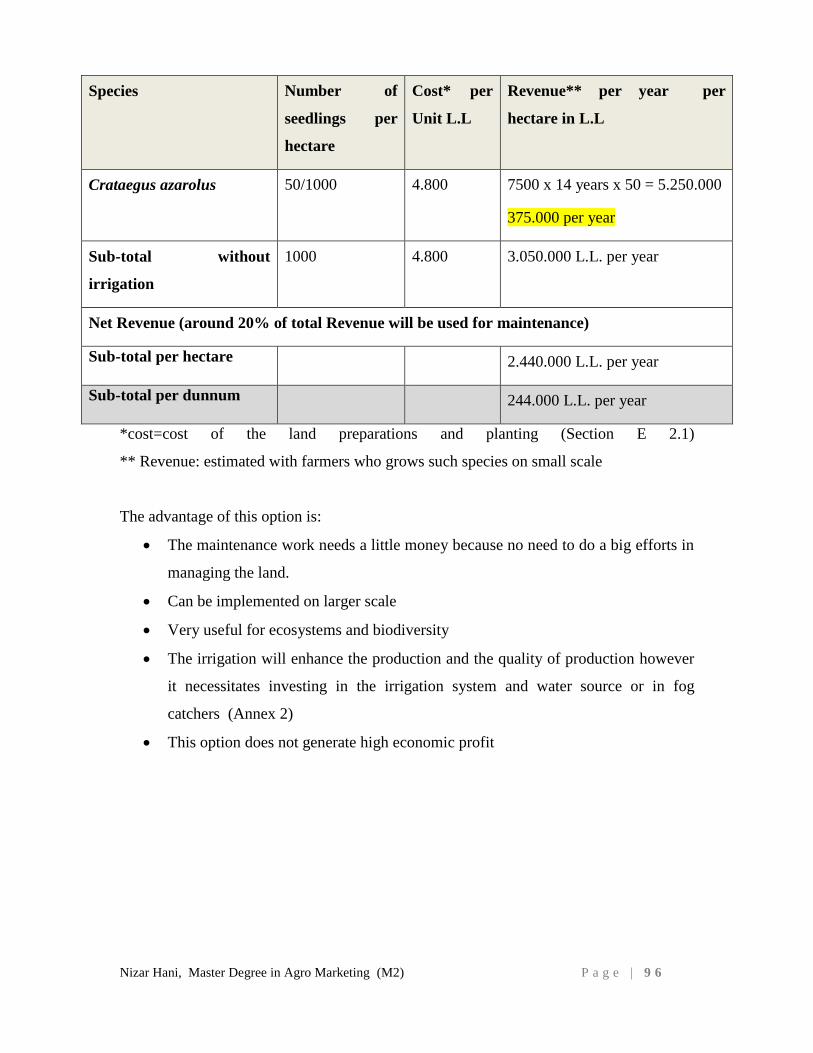
Nizar Hani, Master Degree in Agro Marketing (M2) P a g e | 9 6
Species Number of
seedlings per
hectare
Cost* per
Unit L.L
Revenue** per year per
hectare in L.L
Crataegus azarolus 50/1000 4.800 7500 x 14 years x 50 = 5.250.000
375.000 per year
Sub-total without
irrigation
1000 4.800 3.050.000 L.L. per year
Net Revenue (around 20% of total Revenue will be used for maintenance)
Sub-total per hectare 2.440.000 L.L. per year
Sub-total per dunnum 244.000 L.L. per year
*cost=cost of the land preparations and planting (Section E 2.1)
** Revenue: estimated with farmers who grows such species on small scale
The advantage of this option is:
The maintenance work needs a little money because no need to do a big efforts in
managing the land.
Can be implemented on larger scale
Very useful for ecosystems and biodiversity
The irrigation will enhance the production and the quality of production however
it necessitates investing in the irrigation system and water source or in fog
catchers (Annex 2)
This option does not generate high economic profit
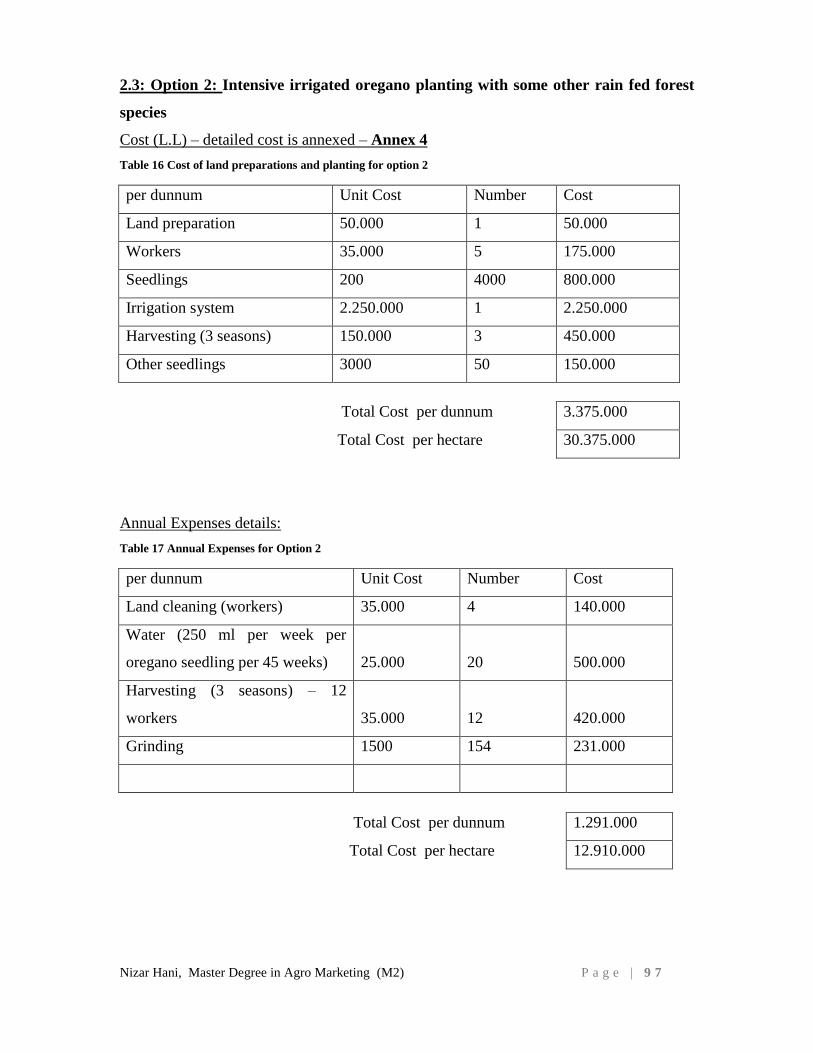
Nizar Hani, Master Degree in Agro Marketing (M2) P a g e | 9 7
2.3: Option 2: Intensive irrigated oregano planting with some other rain fed forest
species
Cost (L.L) – detailed cost is annexed – Annex 4
Table 16 Cost of land preparations and planting for option 2
per dunnum Unit Cost Number Cost
Land preparation 50.000 1 50.000
Workers 35.000 5 175.000
Seedlings 200 4000 800.000
Irrigation system 2.250.000 1 2.250.000
Harvesting (3 seasons) 150.000 3 450.000
Other seedlings 3000 50 150.000
Total Cost per dunnum 3.375.000
Total Cost per hectare 30.375.000
Annual Expenses details:
Table 17 Annual Expenses for Option 2
per dunnum Unit Cost Number Cost
Land cleaning (workers) 35.000 4 140.000
Water (250 ml per week per
oregano seedling per 45 weeks) 25.000 20 500.000
Harvesting (3 seasons) – 12
workers 35.000 12 420.000
Grinding 1500 154 231.000
Total Cost per dunnum 1.291.000
Total Cost per hectare 12.910.000
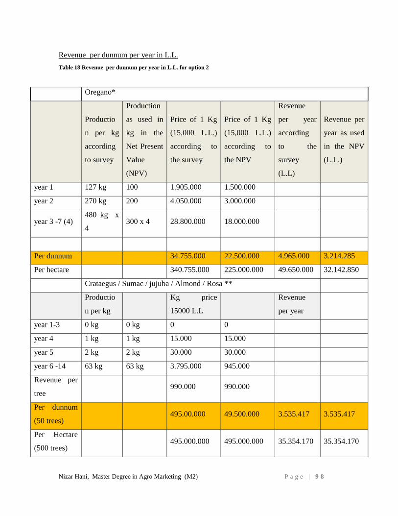
Nizar Hani, Master Degree in Agro Marketing (M2) P a g e | 9 8
Revenue per dunnum per year in L.L.
Table 18 Revenue per dunnum per year in L.L. for option 2
Oregano*
Productio
n per kg
according
to survey
Production
as used in
kg in the
Net Present
Value
(NPV)
Price of 1 Kg
(15,000 L.L.)
according to
the survey
Price of 1 Kg
(15,000 L.L.)
according to
the NPV
Revenue
per year
according
to the
survey
(L.L)
Revenue per
year as used
in the NPV
(L.L.)
year 1 127 kg 100 1.905.000 1.500.000
year 2 270 kg 200 4.050.000 3.000.000
year 3 -7 (4) 480 kg x
4 300 x 4 28.800.000 18.000.000
Per dunnum 34.755.000 22.500.000 4.965.000 3.214.285
Per hectare 340.755.000 225.000.000 49.650.000 32.142.850
Crataegus / Sumac / jujuba / Almond / Rosa **
Productio
n per kg
Kg price
15000 L.L
Revenue
per year
year 1-3 0 kg 0 kg 0 0
year 4 1 kg 1 kg 15.000 15.000
year 5 2 kg 2 kg 30.000 30.000
year 6 -14 63 kg 63 kg 3.795.000 945.000
Revenue per
tree 990.000 990.000
Per dunnum
(50 trees) 495.00.000 49.500.000 3.535.417 3.535.417
Per Hectare
(500 trees) 495.000.000 495.000.000 35.354.170 35.354.170
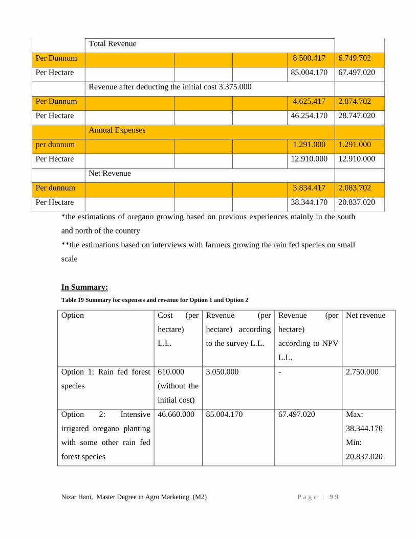
Nizar Hani, Master Degree in Agro Marketing (M2) P a g e | 9 9
*the estimations of oregano growing based on previous experiences mainly in the south
and north of the country
**the estimations based on interviews with farmers growing the rain fed species on small
scale
In Summary:
Table 19 Summary for expenses and revenue for Option 1 and Option 2
Option Cost (per
hectare)
L.L.
Revenue (per
hectare) according
to the survey L.L.
Revenue (per
hectare)
according to NPV
L.L.
Net revenue
Option 1: Rain fed forest
species
610.000
(without the
initial cost)
3.050.000 - 2.750.000
Option 2: Intensive
irrigated oregano planting
with some other rain fed
forest species
46.660.000 85.004.170 67.497.020 Max:
38.344.170
Min:
20.837.020
Total Revenue
Per Dunnum 8.500.417 6.749.702
Per Hectare 85.004.170 67.497.020
Revenue after deducting the initial cost 3.375.000
Per Dunnum 4.625.417 2.874.702
Per Hectare 46.254.170 28.747.020
Annual Expenses
per dunnum 1.291.000 1.291.000
Per Hectare 12.910.000 12.910.000
Net Revenue
Per dunnum 3.834.417 2.083.702
Per Hectare 38.344.170 20.837.020

Nizar Hani, Master Degree in Agro Marketing (M2) P a g e | 1 0 0
Both options estimations based on direct contact with farmers and institutions which
implemented such activities in Lebanon mainly the oregano plantation in the South and
North of Lebanon, regarding the trees and shrubs our estimations mainly on farmer
experiences and knowledge on small scale.
The proposed innovative approach in the present study is the combination of both in one
plot, using sustainable and innovative cultural practices such as drip irrigation and fog
catchers. The main objective remains to be the income generating aspect of the activity
whereby the sustainable practices are still maintained and enhanced to enable the
restoration and good management of the ecosystem.
Based on the results of the cost benefit analysis the option two is more beneficial for the
farmer on a minimum of one hectare. Farmers would work as a group to be able to make
the benefit aimed for, and establish a partnership with the land owners who are not able
to restore their lands. Restoring surfaces of 2-3 hectares will be useful for the ecosystems,
landscapes, famers and land owners.
F.3. NET PRESENT VALUE CRITERION FOR OPTION 2:
According to this criterion, a project is economically viable if its “Net Present Value –
NPV” is greater than zero. ‘Net Present Value (NPV)’ is defined as the difference
between discounted benefits and discounted costs of a certain project. The rate of
discount applied represents the cost of capital to the owners of the project and the period
of discounting extends until the terminal year of the project. A salvage value, if it exists,
is credited at the last year. The project is considered economically viable if the NPV is
greater than zero.
The NPV can be expressed as follows:
NPV = -C0+ R1-C1/(1+r)^1 +R2-C2/(1+r)^2 +…..+ Rn-Cn +Sn/(1+r)^n
Where
C0: Immediate capital cost of the project.
C1….Cn: Capital cost and operating cost incurred in each respective year.
R1....Rn: Expected revenue stream of project.
r: Rate of discount used which is equivalent to the cost of capital to the owner.
n:Life span of the project.
Sn: Salvage value of the investment at year n.
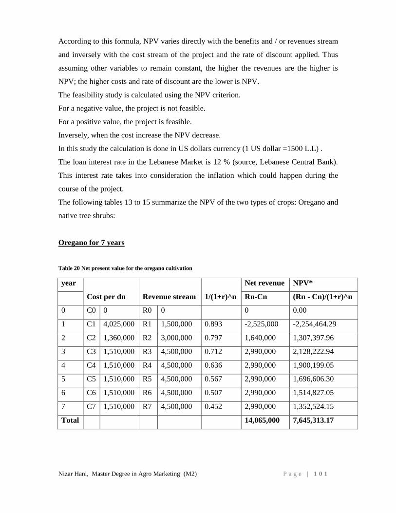
Nizar Hani, Master Degree in Agro Marketing (M2) P a g e | 1 0 1
According to this formula, NPV varies directly with the benefits and / or revenues stream
and inversely with the cost stream of the project and the rate of discount applied. Thus
assuming other variables to remain constant, the higher the revenues are the higher is
NPV; the higher costs and rate of discount are the lower is NPV.
The feasibility study is calculated using the NPV criterion.
For a negative value, the project is not feasible.
For a positive value, the project is feasible.
Inversely, when the cost increase the NPV decrease.
In this study the calculation is done in US dollars currency (1 US dollar =1500 L.L) .
The loan interest rate in the Lebanese Market is 12 % (source, Lebanese Central Bank).
This interest rate takes into consideration the inflation which could happen during the
course of the project.
The following tables 13 to 15 summarize the NPV of the two types of crops: Oregano and
native tree shrubs:
Oregano for 7 years
Table 20 Net present value for the oregano cultivation
year
Cost per dn Revenue stream 1/(1+r)^n
Net revenue NPV*
Rn-Cn (Rn - Cn)/(1+r)^n
0 C0 0 R0 0 0 0.00
1 C1 4,025,000 R1 1,500,000 0.893 -2,525,000 -2,254,464.29
2 C2 1,360,000 R2 3,000,000 0.797 1,640,000 1,307,397.96
3 C3 1,510,000 R3 4,500,000 0.712 2,990,000 2,128,222.94
4 C4 1,510,000 R4 4,500,000 0.636 2,990,000 1,900,199.05
5 C5 1,510,000 R5 4,500,000 0.567 2,990,000 1,696,606.30
6 C6 1,510,000 R6 4,500,000 0.507 2,990,000 1,514,827.05
7 C7 1,510,000 R7 4,500,000 0.452 2,990,000 1,352,524.15
Total 14,065,000 7,645,313.17
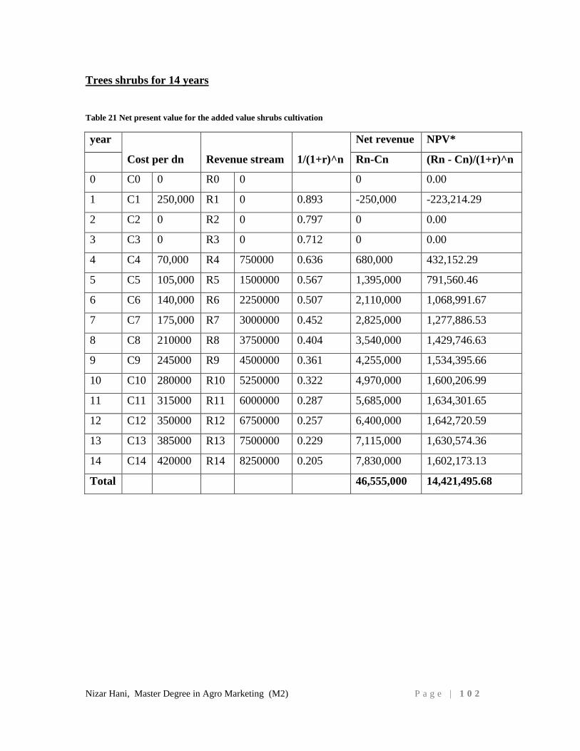
Nizar Hani, Master Degree in Agro Marketing (M2) P a g e | 1 0 2
Trees shrubs for 14 years
Table 21 Net present value for the added value shrubs cultivation
year
Cost per dn Revenue stream 1/(1+r)^n
Net revenue NPV*
Rn-Cn (Rn - Cn)/(1+r)^n
0 C0 0 R0 0 0 0.00
1 C1 250,000 R1 0 0.893 -250,000 -223,214.29
2 C2 0 R2 0 0.797 0 0.00
3 C3 0 R3 0 0.712 0 0.00
4 C4 70,000 R4 750000 0.636 680,000 432,152.29
5 C5 105,000 R5 1500000 0.567 1,395,000 791,560.46
6 C6 140,000 R6 2250000 0.507 2,110,000 1,068,991.67
7 C7 175,000 R7 3000000 0.452 2,825,000 1,277,886.53
8 C8 210000 R8 3750000 0.404 3,540,000 1,429,746.63
9 C9 245000 R9 4500000 0.361 4,255,000 1,534,395.66
10 C10 280000 R10 5250000 0.322 4,970,000 1,600,206.99
11 C11 315000 R11 6000000 0.287 5,685,000 1,634,301.65
12 C12 350000 R12 6750000 0.257 6,400,000 1,642,720.59
13 C13 385000 R13 7500000 0.229 7,115,000 1,630,574.36
14 C14 420000 R14 8250000 0.205 7,830,000 1,602,173.13
Total 46,555,000 14,421,495.68
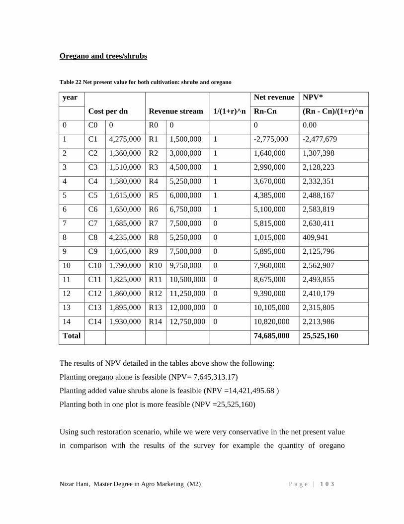
Nizar Hani, Master Degree in Agro Marketing (M2) P a g e | 1 0 3
Oregano and trees/shrubs
Table 22 Net present value for both cultivation: shrubs and oregano
year
Cost per dn Revenue stream 1/(1+r)^n
Net revenue NPV*
Rn-Cn (Rn - Cn)/(1+r)^n
0 C0 0 R0 0 0 0.00
1 C1 4,275,000 R1 1,500,000 1 -2,775,000 -2,477,679
2 C2 1,360,000 R2 3,000,000 1 1,640,000 1,307,398
3 C3 1,510,000 R3 4,500,000 1 2,990,000 2,128,223
4 C4 1,580,000 R4 5,250,000 1 3,670,000 2,332,351
5 C5 1,615,000 R5 6,000,000 1 4,385,000 2,488,167
6 C6 1,650,000 R6 6,750,000 1 5,100,000 2,583,819
7 C7 1,685,000 R7 7,500,000 0 5,815,000 2,630,411
8 C8 4,235,000 R8 5,250,000 0 1,015,000 409,941
9 C9 1,605,000 R9 7,500,000 0 5,895,000 2,125,796
10 C10 1,790,000 R10 9,750,000 0 7,960,000 2,562,907
11 C11 1,825,000 R11 10,500,000 0 8,675,000 2,493,855
12 C12 1,860,000 R12 11,250,000 0 9,390,000 2,410,179
13 C13 1,895,000 R13 12,000,000 0 10,105,000 2,315,805
14 C14 1,930,000 R14 12,750,000 0 10,820,000 2,213,986
Total 74,685,000 25,525,160
The results of NPV detailed in the tables above show the following:
Planting oregano alone is feasible (NPV= 7,645,313.17)
Planting added value shrubs alone is feasible (NPV =14,421,495.68 )
Planting both in one plot is more feasible (NPV =25,525,160)
Using such restoration scenario, while we were very conservative in the net present value
in comparison with the results of the survey for example the quantity of oregano
Nizar Hani, Master Degree in Agro Marketing (M2) P a g e | 1 0 4
produced in year 1 is 100 kg instead of 127 kg and 200 kg instead of 270 kg in year 2 as
well as 300 kg in year 3 instead of 480 kg.
Also we calculated the cost of one kg of oregano in 15.000 L.L and that is the minimum
cost for big quantities, if the farmer is able to follow the labelling, packaging and
marketing recommendations of this study the price of one kg of oregano can be sold
between 30.000 and 40.000 L.L. and that is applicable on the added value shrubs/trees
which can produce several economic value products using the fruits and flowers as
mentioned in the section E1.
The combination of oregano and rain fed forest native shrubs is a safer cropping system
which also reduces the risk of loss of oregano due to any adverse climatic conditions
and/or market fluctuation which will affect oregano since it is more sensitive than the
shrubs.
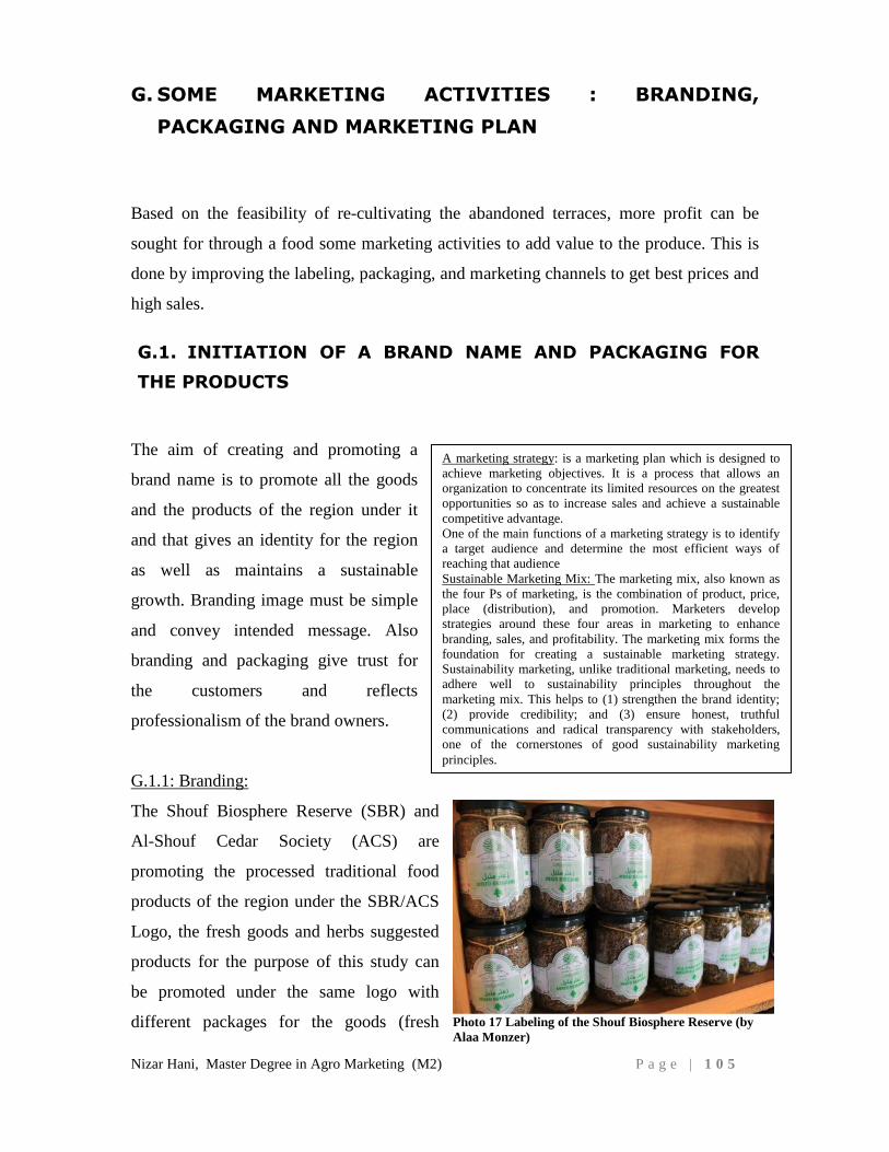
Nizar Hani, Master Degree in Agro Marketing (M2) P a g e | 1 0 5
G. SOME MARKETING ACTIVITIES : BRANDING,
PACKAGING AND MARKETING PLAN
Based on the feasibility of re-cultivating the abandoned terraces, more profit can be
sought for through a food some marketing activities to add value to the produce. This is
done by improving the labeling, packaging, and marketing channels to get best prices and
high sales.
G.1. INITIATION OF A BRAND NAME AND PACKAGING FOR
THE PRODUCTS
The aim of creating and promoting a
brand name is to promote all the goods
and the products of the region under it
and that gives an identity for the region
as well as maintains a sustainable
growth. Branding image must be simple
and convey intended message. Also
branding and packaging give trust for
the customers and reflects
professionalism of the brand owners.
G.1.1: Branding:
The Shouf Biosphere Reserve (SBR) and
Al-Shouf Cedar Society (ACS) are
promoting the processed traditional food
products of the region under the SBR/ACS
Logo, the fresh goods and herbs suggested
products for the purpose of this study can
be promoted under the same logo with
different packages for the goods (fresh
A marketing strategy: is a marketing plan which is designed to
achieve marketing objectives. It is a process that allows an
organization to concentrate its limited resources on the greatest
opportunities so as to increase sales and achieve a sustainable
competitive advantage.
One of the main functions of a marketing strategy is to identify
a target audience and determine the most efficient ways of
reaching that audience
Sustainable Marketing Mix: The marketing mix, also known as
the four Ps of marketing, is the combination of product, price,
place (distribution), and promotion. Marketers develop
strategies around these four areas in marketing to enhance
branding, sales, and profitability. The marketing mix forms the
foundation for creating a sustainable marketing strategy.
Sustainability marketing, unlike traditional marketing, needs to
adhere well to sustainability principles throughout the
marketing mix. This helps to (1) strengthen the brand identity;
(2) provide credibility; and (3) ensure honest, truthful
communications and radical transparency with stakeholders,
one of the cornerstones of good sustainability marketing
principles.
Photo 17 Labeling of the Shouf Biosphere Reserve (by
Alaa Monzer)
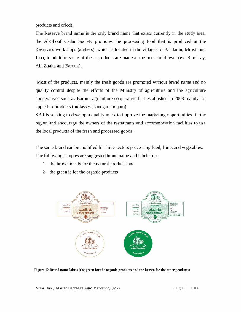
Nizar Hani, Master Degree in Agro Marketing (M2) P a g e | 1 0 6
products and dried).
The Reserve brand name is the only brand name that exists currently in the study area,
the Al-Shouf Cedar Society promotes the processing food that is produced at the
Reserve’s workshops (ateliers), which is located in the villages of Baadaran, Mrusti and
Jbaa, in addition some of these products are made at the household level (ex. Bmohray,
Ain Zhalta and Barouk).
Most of the products, mainly the fresh goods are promoted without brand name and no
quality control despite the efforts of the Ministry of agriculture and the agriculture
cooperatives such as Barouk agriculture cooperative that established in 2008 mainly for
apple bio-products (molasses , vinegar and jam)
SBR is seeking to develop a quality mark to improve the marketing opportunities in the
region and encourage the owners of the restaurants and accommodation facilities to use
the local products of the fresh and processed goods.
The same brand can be modified for three sectors processing food, fruits and vegetables.
The following samples are suggested brand name and labels for:
1- the brown one is for the natural products and
2- the green is for the organic products
Figure 12 Brand name labels (the green for the organic products and the brown for the other products)
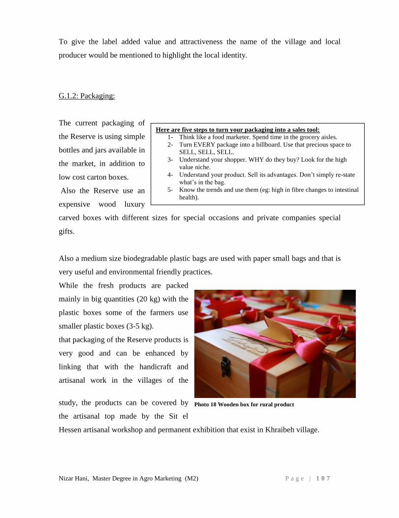
Nizar Hani, Master Degree in Agro Marketing (M2) P a g e | 1 0 7
To give the label added value and attractiveness the name of the village and local
producer would be mentioned to highlight the local identity.
G.1.2: Packaging:
The current packaging of
the Reserve is using simple
bottles and jars available in
the market, in addition to
low cost carton boxes.
Also the Reserve use an
expensive wood luxury
carved boxes with different sizes for special occasions and private companies special
gifts.
Also a medium size biodegradable plastic bags are used with paper small bags and that is
very useful and environmental friendly practices.
While the fresh products are packed
mainly in big quantities (20 kg) with the
plastic boxes some of the farmers use
smaller plastic boxes (3-5 kg).
that packaging of the Reserve products is
very good and can be enhanced by
linking that with the handicraft and
artisanal work in the villages of the
study, the products can be covered by
the artisanal top made by the Sit el
Hessen artisanal workshop and permanent exhibition that exist in Khraibeh village.
Here are five steps to turn your packaging into a sales tool:
1- Think like a food marketer. Spend time in the grocery aisles.
2- Turn EVERY package into a billboard. Use that precious space to
SELL, SELL, SELL.
3- Understand your shopper. WHY do they buy? Look for the high
value niche.
4- Understand your product. Sell its advantages. Don’t simply re-state
what’s in the bag.
5- Know the trends and use them (eg: high in fibre changes to intestinal
health).
Photo 18 Wooden box for rural product
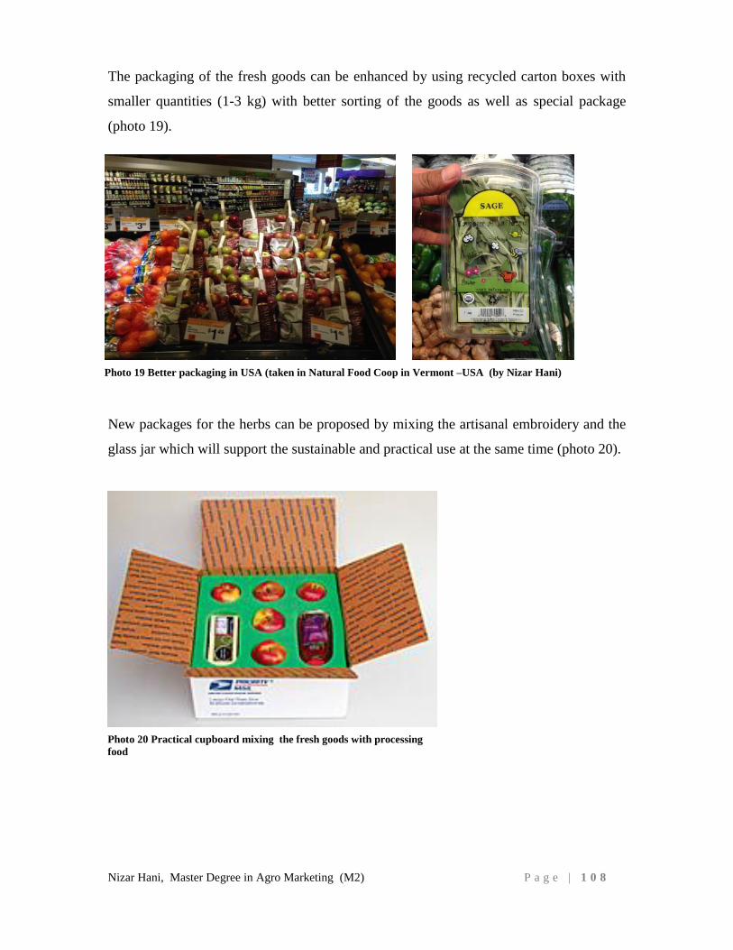
Nizar Hani, Master Degree in Agro Marketing (M2) P a g e | 1 0 8
The packaging of the fresh goods can be enhanced by using recycled carton boxes with
smaller quantities (1-3 kg) with better sorting of the goods as well as special package
(photo 19).
New packages for the herbs can be proposed by mixing the artisanal embroidery and the
glass jar which will support the sustainable and practical use at the same time (photo 20).
Photo 19 Better packaging in USA (taken in Natural Food Coop in Vermont –USA (by Nizar Hani)
Photo 20 Practical cupboard mixing the fresh goods with processing
food
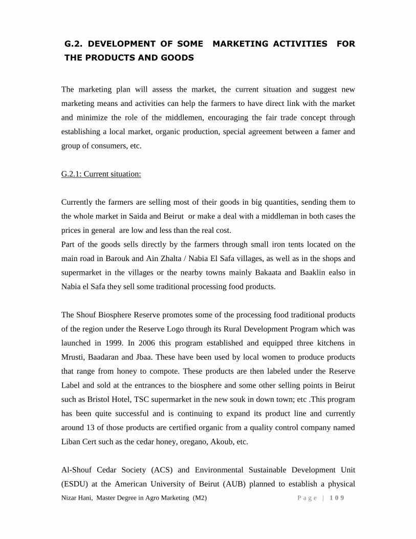
Nizar Hani, Master Degree in Agro Marketing (M2) P a g e | 1 0 9
G.2. DEVELOPMENT OF SOME MARKETING ACTIVITIES FOR
THE PRODUCTS AND GOODS
The marketing plan will assess the market, the current situation and suggest new
marketing means and activities can help the farmers to have direct link with the market
and minimize the role of the middlemen, encouraging the fair trade concept through
establishing a local market, organic production, special agreement between a famer and
group of consumers, etc.
G.2.1: Current situation:
Currently the farmers are selling most of their goods in big quantities, sending them to
the whole market in Saida and Beirut or make a deal with a middleman in both cases the
prices in general are low and less than the real cost.
Part of the goods sells directly by the farmers through small iron tents located on the
main road in Barouk and Ain Zhalta / Nabia El Safa villages, as well as in the shops and
supermarket in the villages or the nearby towns mainly Bakaata and Baaklin ealso in
Nabia el Safa they sell some traditional processing food products.
The Shouf Biosphere Reserve promotes some of the processing food traditional products
of the region under the Reserve Logo through its Rural Development Program which was
launched in 1999. In 2006 this program established and equipped three kitchens in
Mrusti, Baadaran and Jbaa. These have been used by local women to produce products
that range from honey to compote. These products are then labeled under the Reserve
Label and sold at the entrances to the biosphere and some other selling points in Beirut
such as Bristol Hotel, TSC supermarket in the new souk in down town; etc .This program
has been quite successful and is continuing to expand its product line and currently
around 13 of those products are certified organic from a quality control company named
Liban Cert such as the cedar honey, oregano, Akoub, etc.
Al-Shouf Cedar Society (ACS) and Environmental Sustainable Development Unit
(ESDU) at the American University of Beirut (AUB) planned to establish a physical
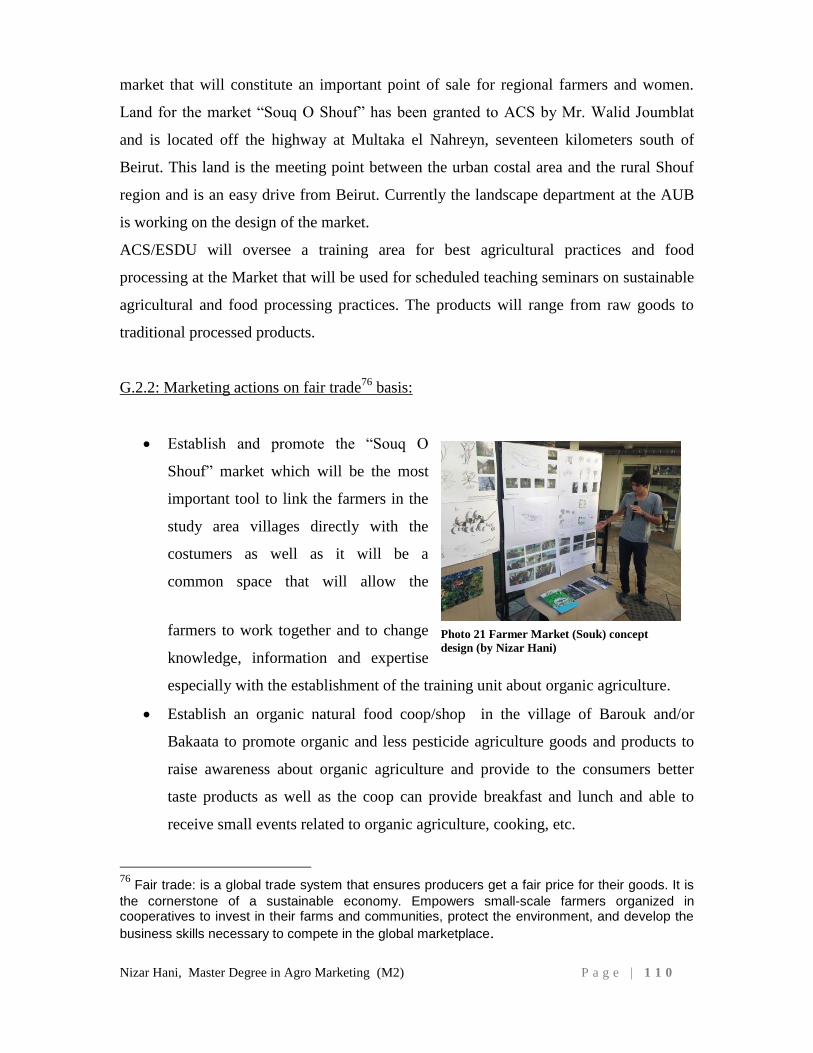
Nizar Hani, Master Degree in Agro Marketing (M2) P a g e | 1 1 0
market that will constitute an important point of sale for regional farmers and women.
Land for the market “Souq O Shouf” has been granted to ACS by Mr. Walid Joumblat
and is located off the highway at Multaka el Nahreyn, seventeen kilometers south of
Beirut. This land is the meeting point between the urban costal area and the rural Shouf
region and is an easy drive from Beirut. Currently the landscape department at the AUB
is working on the design of the market.
ACS/ESDU will oversee a training area for best agricultural practices and food
processing at the Market that will be used for scheduled teaching seminars on sustainable
agricultural and food processing practices. The products will range from raw goods to
traditional processed products.
G.2.2: Marketing actions on fair trade76
basis:
Establish and promote the “Souq O
Shouf” market which will be the most
important tool to link the farmers in the
study area villages directly with the
costumers as well as it will be a
common space that will allow the
farmers to work together and to change
knowledge, information and expertise
especially with the establishment of the training unit about organic agriculture.
Establish an organic natural food coop/shop in the village of Barouk and/or
Bakaata to promote organic and less pesticide agriculture goods and products to
raise awareness about organic agriculture and provide to the consumers better
taste products as well as the coop can provide breakfast and lunch and able to
receive small events related to organic agriculture, cooking, etc.
76
Fair trade: is a global trade system that ensures producers get a fair price for their goods. It is
the cornerstone of a sustainable economy. Empowers small-scale farmers organized in cooperatives to invest in their farms and communities, protect the environment, and develop the
business skills necessary to compete in the global marketplace.
Photo 21 Farmer Market (Souk) concept
design (by Nizar Hani)
Nizar Hani, Master Degree in Agro Marketing (M2) P a g e | 1 1 1
Use the local festivals in the study area to
promote the farmer market as well as the
products and the goods while some of
those festivals are well known and able
to attract large number of visitors mainly
Nabiaa el Barouk, Jabalna Maasser el
Chouf and Mawassem Mrusti festivals.
Strengthen the linkage between the
farmers and the Reserve entrances that receive every year around 70,000 visitors
to promote in addition to the processing food products the fresh goods for
example we can gift an apple for each visitor.
Create a special program called “CEDARS and FARMERS” between groups of
consumers and small farmers, make an agreement between 10-12 consumers
living in the same neighborhood and a small farmer to produce their needed fruits
and vegetables as well as processing traditional products, in that case the
consumers can ensure a minimum quality of goods and the farmer can ensure
minimum income stability to sustain his farming investment (John P.,2008)77
.
Create linkages between the local restaurants, hotel and guesthouse owners and
the farmers to provide their needs especially in Barouk and Ain Zhalta / Nabiaa El
Safa where more than dozen of restaurants and accommodation facilities exist.
Establish in Ain Zhalta village a “Farm Restaurant” to provide special service for
the eco-tourists of the Shouf Biosphere Reserve as well as to promote the Shouf
Terroir products such as the Bioland –from farm to fork farm restaurant in
Batroun region (http://bioland-lb.com/home.php)
Establish a Food Heritage Trail to encourage the agro-tourism packages through
the Reserve eco-tourism program and share it with tour operators and travel
agencies and train the local guides and farmers about promoting agriculture to the
eco-tourists.
Organize by the agriculture cooperatives some summer activities to promote the
agriculture in the study area site for example Apple festival in Barouk, Cherry
77
John P., 2008. "The Lost History of Organic Farming in Australia", Journal of Organic Systems.
Photo 22 Middlebury Natural Food Coop (by
Nizar Hani)
Nizar Hani, Master Degree in Agro Marketing (M2) P a g e | 1 1 2
festival in Niha, Peach festival in Ain Zhalta and Oregano festival in Mrusti in
close cooperation with the Reserve, municipalities and ministry of agriculture.
Foster the farmers to participate in the agro food national and regional exhibitions
such as HORECA, Garden show, Beirut cooking festival, Souk el Tayeb, Ataya
exhibition in Abou Dhabi.
Organize volunteering days to provide for the farmers the manpower and help the
farmers in collecting the goods, spraying the trees, cleaning the land, etc.
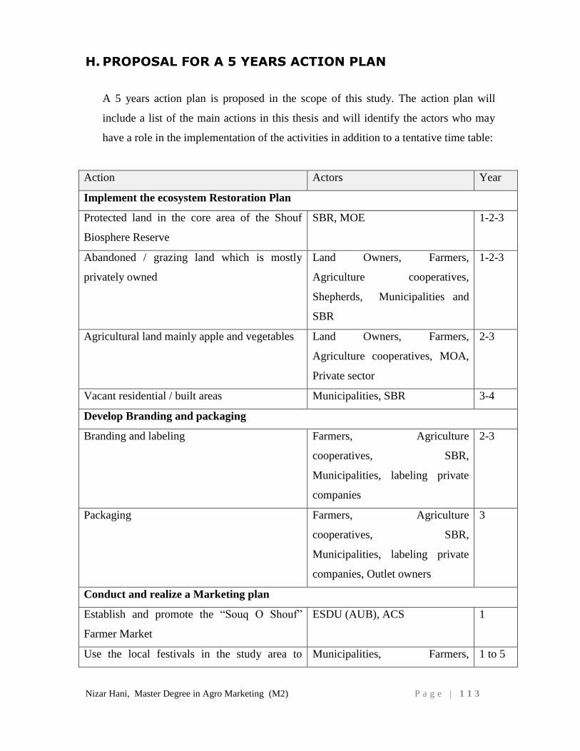
Nizar Hani, Master Degree in Agro Marketing (M2) P a g e | 1 1 3
H. PROPOSAL FOR A 5 YEARS ACTION PLAN
A 5 years action plan is proposed in the scope of this study. The action plan will
include a list of the main actions in this thesis and will identify the actors who may
have a role in the implementation of the activities in addition to a tentative time table:
Action Actors Year
Implement the ecosystem Restoration Plan
Protected land in the core area of the Shouf
Biosphere Reserve
SBR, MOE 1-2-3
Abandoned / grazing land which is mostly
privately owned
Land Owners, Farmers,
Agriculture cooperatives,
Shepherds, Municipalities and
SBR
1-2-3
Agricultural land mainly apple and vegetables Land Owners, Farmers,
Agriculture cooperatives, MOA,
Private sector
2-3
Vacant residential / built areas Municipalities, SBR 3-4
Develop Branding and packaging
Branding and labeling Farmers, Agriculture
cooperatives, SBR,
Municipalities, labeling private
companies
2-3
Packaging Farmers, Agriculture
cooperatives, SBR,
Municipalities, labeling private
companies, Outlet owners
3
Conduct and realize a Marketing plan
Establish and promote the “Souq O Shouf”
Farmer Market
ESDU (AUB), ACS 1
Use the local festivals in the study area to Municipalities, Farmers, 1 to 5
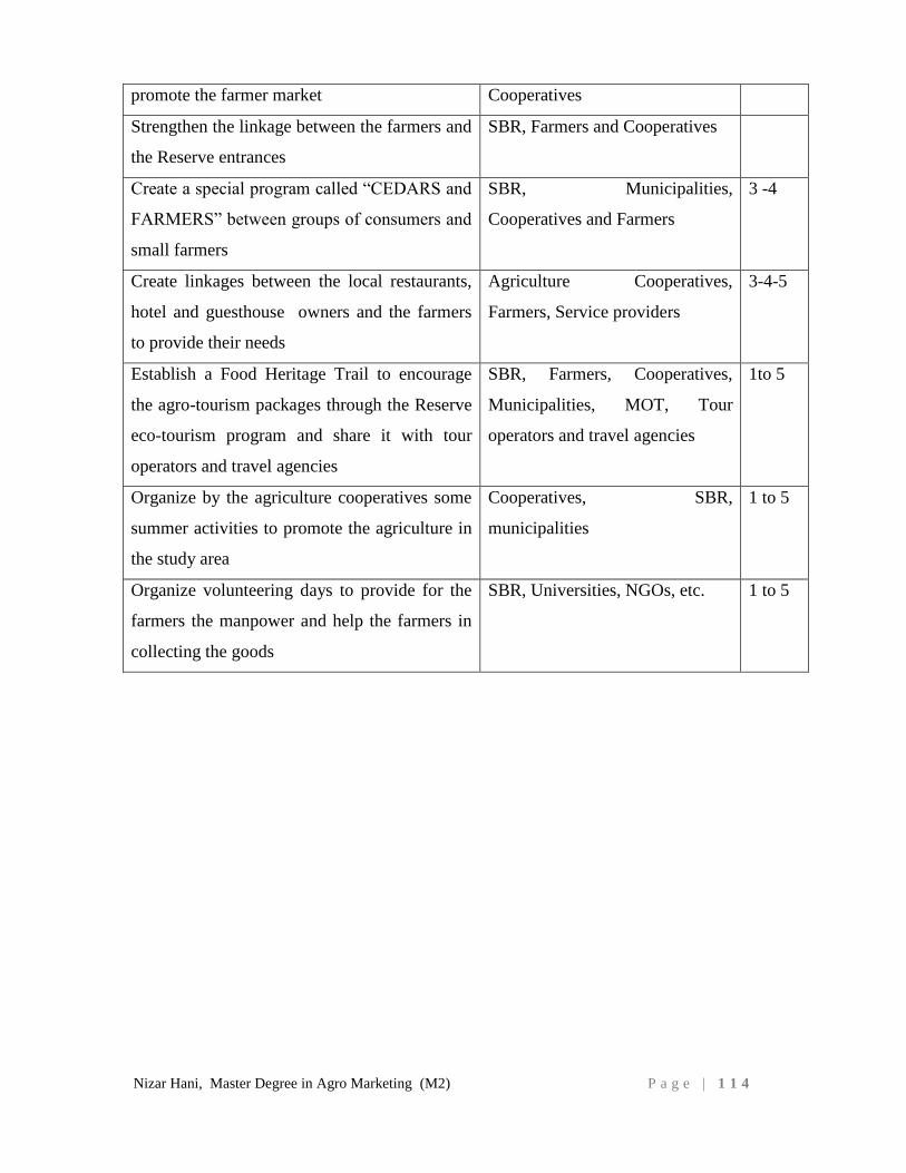
Nizar Hani, Master Degree in Agro Marketing (M2) P a g e | 1 1 4
promote the farmer market Cooperatives
Strengthen the linkage between the farmers and
the Reserve entrances
SBR, Farmers and Cooperatives
Create a special program called “CEDARS and
FARMERS” between groups of consumers and
small farmers
SBR, Municipalities,
Cooperatives and Farmers
3 -4
Create linkages between the local restaurants,
hotel and guesthouse owners and the farmers
to provide their needs
Agriculture Cooperatives,
Farmers, Service providers
3-4-5
Establish a Food Heritage Trail to encourage
the agro-tourism packages through the Reserve
eco-tourism program and share it with tour
operators and travel agencies
SBR, Farmers, Cooperatives,
Municipalities, MOT, Tour
operators and travel agencies
1to 5
Organize by the agriculture cooperatives some
summer activities to promote the agriculture in
the study area
Cooperatives, SBR,
municipalities
1 to 5
Organize volunteering days to provide for the
farmers the manpower and help the farmers in
collecting the goods
SBR, Universities, NGOs, etc. 1 to 5
Nizar Hani, Master Degree in Agro Marketing (M2) P a g e | 1 1 5
I. LIMITATIONS
Despite the full cooperation of the study relative stakeholders and the study is in the
framework of my work as a manager of the Shouf Biosphere Reserve and accessibility
of the available data but some limitations faced the study:
1- The unavailability of accurate data on the production of the rain fed species that we
suggested to be planted in the abandoned terraces
2- The presence of only the small scale oregano growing projects in the study area
most of the big initiative that we based our cost benefit analysis on are located in
different regions in Lebanon with different climate change
3- The marketing strategy section is just including some guidelines to be baseline for a
more integrated marketing detailed strategy in future studies including the creation
of a brand for the region
4- The unavailability of enough references about the abandoned terraces in Lebanon
5- The action plan can be detailed more in future studies in case the restoration
activities of this study adopted in the study area and decide to be implemented
6- The use of some old references in some areas because of the unavailability of new
references such as the geological map of Lebanon dated 1955, the land use land
cover map dated 1998
Nizar Hani, Master Degree in Agro Marketing (M2) P a g e | 1 1 6
J. CONCLUSION
More than 600 hectares are able to be restored in the study area using the restoration
scenario which is suggested in this study. The restoration cost of one irrigated hectare is
around USD 20,000 and the annual net revenue ranges between a minimum of USD
13,000 and a maximum of USD 26,000 per year. Hence, the restoration of the 600
hectares of abandoned terraces in the study area is able to provide an income to the area
between at least USD 7.8 million and can be reached 15.6 million per year.
Furthermore, this study will provide a new management approach of the old abandoned
terraces which is the establishment of cooperation between a group of land owners and
a group of active farmers to manage lands with surface ranging between 2 and 3
hectares.
These activities will participate in enhancing livelihoods of local small-scale producers
and hence the socio-economic situation in the region, providing hundreds of job
opportunities, strengthening the relationship between the land owners and producers,
creating better land use management and landscape in the area, giving the region its
uniqueness and reputation, enhance the eco-tourism attractions.
Nizar Hani, Master Degree in Agro Marketing (M2) P a g e | 1 1 7
K. RECOMMENDATIONS
Based on this study, the following recommendations are proposed:
Providing water to the old terraces will be essential by establishing small hill lakes taking
into consideration the environmental impact assessment approach to protect and preserve
the landscape and resources which is the main value of the region.
Implementing a demonstration plot to encourage farmers to use the restoration scenarios
that this study is suggesting; one or two demonstration sites managed by a group of active
farmers would be a good stepping stone to replicate at a larger scale and in the region at
large.
Implementing a large scale area will also set a good example by combining small size
surface areas together to form a bigger surface area of 2 to 3 hectares, to be restored and
managed by agriculture cooperatives or group of active farmers in close cooperation with
research institutes, donors, municipalities and Shouf Biosphere Reserve. This will
necessitate cooperation between farmers and land owners to share benefits and possibly
management under pre-agreed contracts or relationships.
Encouraging and seeking support for the existing nurseries in the region mainly
Kahlounier (Baddi) and Ramlieh to produce good quality of certified oregano since the
current main source of oregano seedlings is a nursery in Tyre which is under different
climate conditions.
Using the brand of the Reserve or creating new brand for the whole Shouf region78
will
be a good tool for marketing the produce as well as for quality control because that will
give an added value for the goods of the region.
78
Currently many stakeholders in the Shouf region asked M&C Saatchi (a promotional company) to
prepare a branding and marketing campaign for the Shouf region
Nizar Hani, Master Degree in Agro Marketing (M2) P a g e | 1 1 8
Designing appropriate packaging for both the fresh and processed products will help in
finding better marketing channels.
Developing a detailed marketing strategy will highlight main procedure to follow and
implement to seek better markets.
Establishment of specialty shops to promote the goods of the study area in the region as
well as in Beirut and big cities.
Establishment of a permanent farmers market. A new farmers market is currently in the
process of establishment in Moultaka el Nahrain region where farmers can market their
products on a weekly basis to urban and rural inhabitants.
Entice farmers to participate in local festivals to be promoted their local goods and
products. Such festivals are Jabalna in Maasser el Chouf village, Mawassem Mrusti and
Barouk water source.
Implementing a management for grazing to avoid any conflict in land use in the region
between shepherds and farmers to ensure a good restoration process.
Development of feasibility studies and business plans to evaluate the best scenario that
best suits small scale farmers and processors to improve their livelihoods while
sustainably managing the resources and respecting the SBR regulations.
Finally, building the capacities of the producers will ensure the good implementation of
the proposed scenarios and marketing strategy. The main topics would be as follows:
- Production of better seedlings
- Preparations of the land
- Water management using efficient water catchments and irrigation techniques
- Post-harvest and packaging and labelling
- Organizational and managerial skills to ensure cooperative work and
entrepreneurship thinking.
Nizar Hani, Master Degree in Agro Marketing (M2) P a g e | 1 1 9
L. REFERENCES:
- Abdallah P., 2010.Eco-tourism strategy of Shouf Biosphere Reserve. Page 10
- Abi Said M., 2010. Grazing Assessment Report, Al-Shouf Cedar Reserve.
- Abu-Izzeddine, F., Hitchcock, P., Yamout, L. & A. Serhal. 1999. Al-Shouf Cedar
Nature Reserve Management Plan 2000 – 2005. Ministry of Environment,
Lebanon. Page 9
- Abu-Izzedine F., September 2012. Shouf Biosphere Reserve management plan.
Pages 16-25
- Abu-Izzedine F., Shouf Biosphere Reserve, 2013. Memoirs of a Cedar, a history
of deforestation, a future of conservation. Page 7
- Barbosa O., 2007. “Who benefits from access to green space? A case study from
Sheffield, UK,” Landscape and Urban Planning. Page 187-195
- Batisse, M., 1986. ‘Developing and focusing the biosphere reserve concept’,
Nature and resources
- Colomer R., Regato P., 2013. Shouf Biosphere Reserve Ecosystem Restoration
Plan. Pages 24-41
- Diamond, J.M. 2005. Collapse: How societies choose to fail or succeed. Viking
Pengium, New York.
- ECODIT, 2001. Lebanon State of the Environment Report (SOER). Lebanon :
Ministry of Environment, Lebanese Environment & Development Observatory
(LEDO).
- ECODIT, 2010 . Business and Marketing plan for the rural products, Shouf
Biosphere Reserve. Page 4
- FAO 1991. Technical report on land cover mapping of Lebanon. Remote sensing
center, Rome
- FAO, Asmar F., 2011. Country Pasture/Forage Resource Profiles.
- FAO, MOA, 2010. National Forest Assessment program.
- FAO. 1999 & 2010. “Lebanese Observatory for Agricultural Development
Project”, Agricultural Census 1999 and 2010.
- Halawi D., June 1, 2009. Organic farmers in Lebanon face export hurdles, Daily
Star Lebanon.
Nizar Hani, Master Degree in Agro Marketing (M2) P a g e | 1 2 0
- Hani N., 2013. Project proposal prepared by the municipality of Barouk and
submitted to US International Development Agency – USAID, page 8
- Harris, J.A., Hobbs, R.J, Higgs, E. and Aronson, J. (2006) Ecological restoration
and global climate change. Restoration Ecology 14(2) 170 - 176
- Houghton, R.A. 1991. Tropical deforestation and atmospheric carbon dioxide.
Climate Change 19. Page 99
- IDAL, 2013. Lebanon agriculture fact sheet.
- IFAD, 2007. Livelihoods and gender analysis of the war damage in rural areas of
Lebanon.
- Ishwaran, N., Persic, A. and Tri, N.H. 2008. ‘Concept and practice: the case of
UNESCO biosphere reserves’, Int. J. Environment and Sustainable Development.
- IUCN, 2012. Ecological Restoration for Protected Areas, Principles, Guidelines
and Best Practices, page 3-5.
- Jaradi G., Abi Said M., Tohme G, Sadek R., 2004. Al-Chouf Cedar Nature
Reserve. Biodiversity Assessment and Monitoring in the Protected Areas. Final
Report. National Center for Scientific Research. Ministry of Environment,
Lebanon. Pages 43-47
- Jaradi G., Sadek R. & Abi Said Mounir, 2000. Fauna monitoring manual, part II.
Protected areas project. Green Line Association
- John D Liu, 2011. The Changing Nature of Human Security, Finding
sustainability in Ecosystem restoration, page 21.
- John P., 2008. "The Lost History of Organic Farming in Australia", Journal of
Organic Systems.
- Khalil W., 2012. Shouf Biosphere Reserve is a potential Global Geo-park.
- Kuchelmeister G., 1998. “Urban forestry in the Asia-Pacific region: status and
prospects” Forestry Policy and Planning Divison, Rome and Regional Office for
Asia and the Pacific, Bangkok.
- Lichaa EL Khoury D., Bakhos W., 2003. Land cover-land use map of Lebanon:
technical report.
- Loca Liban website, 2013. www.localiban.org
- MAB France, 2011. Octavius on Biosphere Reserves.
Nizar Hani, Master Degree in Agro Marketing (M2) P a g e | 1 2 1
- Macdonald, 2002. The ecological context: a species population perspective.
Cambridge University Press, Cambridge
- McDonald, D., J.R. Grabtree, G. Wiesinger, T.Dax, N. Stamu, P. Fleury and A
Gibon, 2000. Agricultural abandoned in mountain areas of Europe:
Environmental consequences and policy response. Journal of environmental
management 59: 47-69
- Ministry of Agriculture/Lebanon and United nations Environment Programme
(UNEP), 1996. Biological Diversity of Lebanon – Country Study Report.
- MOA - FAO, 2012. LEBANON Country Programming Framework 2012–2015
(Joint Statement of the Ministry of Agriculture and FAO), pages 9-13.
- MOA - FAO, 2012. LEBANON Country Programming Framework 2012–2015
(Joint Statement of the Ministry of Agriculture and FAO), pages 9-13.
- MOA, 2010. MOA Strategic Framework 2010-2014.
- MOA-FAO, 2012. The national agriculture survey, modified by the Agriculture
Extension Center in Deir El Kamar in 2013.
- MOE, 1998. Land Cover/Land Use maps (scale 1/50,000) for the Lebanese coast,
and for South Lebanon.
- Nehmé M, 1977. Fleurs sauvages du Liban. 3 versions, Arabic, 1981; English,
1978. Beirut : Conseil National de la Recherche Scientifique.
- Pagliani M., IUCN, 2009. Shouf Biosphere Reserve Program Portfolio
- D.A Petersen, 2005. The ecology of restoration: historical links, emerging issues
and unexplored realms, page 662.
- Pinto Correia, T. 1993. Land abandonment: Changes in the land use patterns
around the Mediterranean basin. Soils in the Mediterranean regions: use,
management, and future trend.
- Richard J. Hobbs, 2007. Why old fields? Socioeconomic and ecological causes
and consequences of land abandonment. Page 1
- Sattout E. & S. N. Talhouk. 2001. A Proposed Monitoring Program for the Flora
of the Natural Reserves of Al-Shouf, Ehden and the Palm Islands. Ministry of
Environment, Beirut, Lebanon & Green Line. Lebanon.
- Sattout E., 2010. Integrated biodiversity monitoring plan for Protected Areas in
Lebanon
Nizar Hani, Master Degree in Agro Marketing (M2) P a g e | 1 2 2
- Society for Ecological Restoration International Science & Policy Working
Group, 2004. The SER International Primer on Ecological Restoration.
www.ser.org & Tucson: Society for Ecological Restoration International.
- Tohmé G., Tohmé H., Hraoui S., Karakira M. & Gèze R., 1999. Report on five
protected areas in Lebanon. National Council for Scientific Research. Project
UNDP , no. Leb. 95-G 31-AIG-
- Tsoumas, A., and D. Tasioulas. 1986. Ownership status and use of agricultural
land in Greece. Agricultural Bank of Greece, Athens
- UNDP, 2007. Poverty, Growth and Inequality study in Lebanon.
- UNESCO, 1996. Biosphere reserves: the Seville Strategy and the Framework
Statutory of the World Network. UNESCO, Paris. Page 5
- UNESCO, 2010. Madrid Action Plan 2008-2013. Pages 6-7
- Viki A. Cramer and Richard J. Hobbs, 2007. Old fields, Dynamics and
Restoration of Abandonment Farmland.
- Vitousek, P.M., H.A. Mooney, J. Lubchenco and J. Melillo, 1997. Human
domination of Earth’s ecosystems. Science 277. Page 494
- Wilson, E. O., 1988. Biodiversity. Washington DC: National Academy. ISBN 0-
309-03739-5
- World Bank, 2009. Lebanon Agriculture Public Expenditure Review Note.
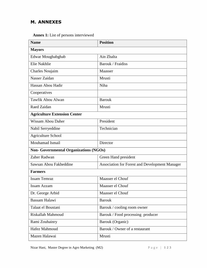
Nizar Hani, Master Degree in Agro Marketing (M2) P a g e | 1 2 3
M. ANNEXES
Annex 1: List of persons interviewed
Name Position
Mayors
Edwar Moughabghab Ain Zhalta
Elie Nakhlie Barouk / Fraidiss
Charles Noujaim Maasser
Nasser Zaidan Mrusti
Hassan Abou Hadir Niha
Cooperatives
Tawfik Abou Alwan Barouk
Raed Zaidan Mrusti
Agriculture Extension Center
Wissam Abou Daher President
Nabil Serryeddine Technician
Agriculture School
Mouhamad Ismail Director
Non- Governmental Organizations (NGOs)
Zaher Radwan Green Hand president
Sawsan Abou Fakheddine Association for Forest and Development Manager
Farmers
Issam Temraz Maasser el Chouf
Issam Azzam Maasser el Chouf
Dr. George Arbid Maasser el Chouf
Bassam Halawi Barouk
Talaat el Boustani Barouk / cooling room owner
Riskallah Mahmoud Barouk / Food processing producer
Rami Zouhainry Barouk (Organic)
Hafez Mahmoud Barouk / Owner of a restaurant
Mazen Halawai Mrusti
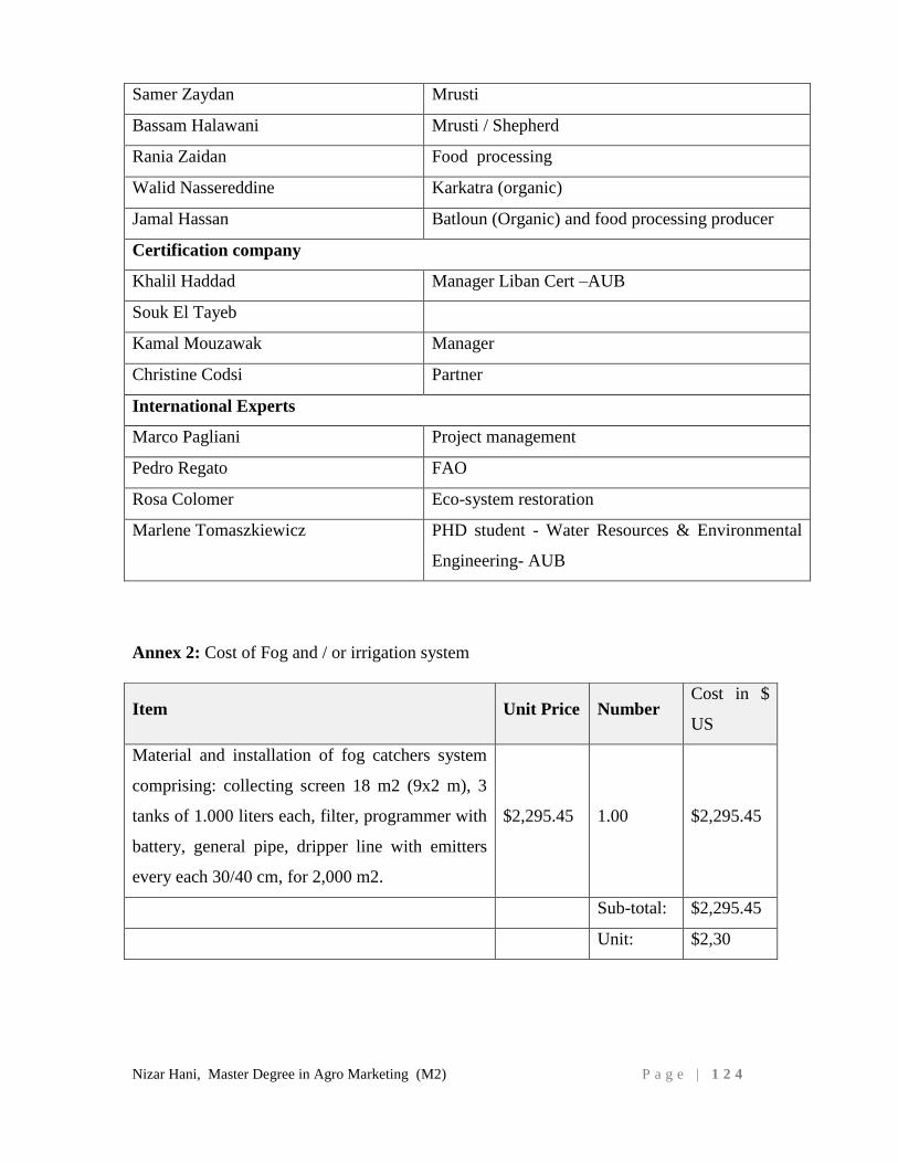
Nizar Hani, Master Degree in Agro Marketing (M2) P a g e | 1 2 4
Samer Zaydan Mrusti
Bassam Halawani Mrusti / Shepherd
Rania Zaidan Food processing
Walid Nassereddine Karkatra (organic)
Jamal Hassan Batloun (Organic) and food processing producer
Certification company
Khalil Haddad Manager Liban Cert –AUB
Souk El Tayeb
Kamal Mouzawak Manager
Christine Codsi Partner
International Experts
Marco Pagliani Project management
Pedro Regato FAO
Rosa Colomer Eco-system restoration
Marlene Tomaszkiewicz PHD student - Water Resources & Environmental
Engineering- AUB
Annex 2: Cost of Fog and / or irrigation system
Item Unit Price Number Cost in $
US
Material and installation of fog catchers system
comprising: collecting screen 18 m2 (9x2 m), 3
tanks of 1.000 liters each, filter, programmer with
battery, general pipe, dripper line with emitters
every each 30/40 cm, for 2,000 m2.
$2,295.45 1.00 $2,295.45
Sub-total: $2,295.45
Unit: $2,30
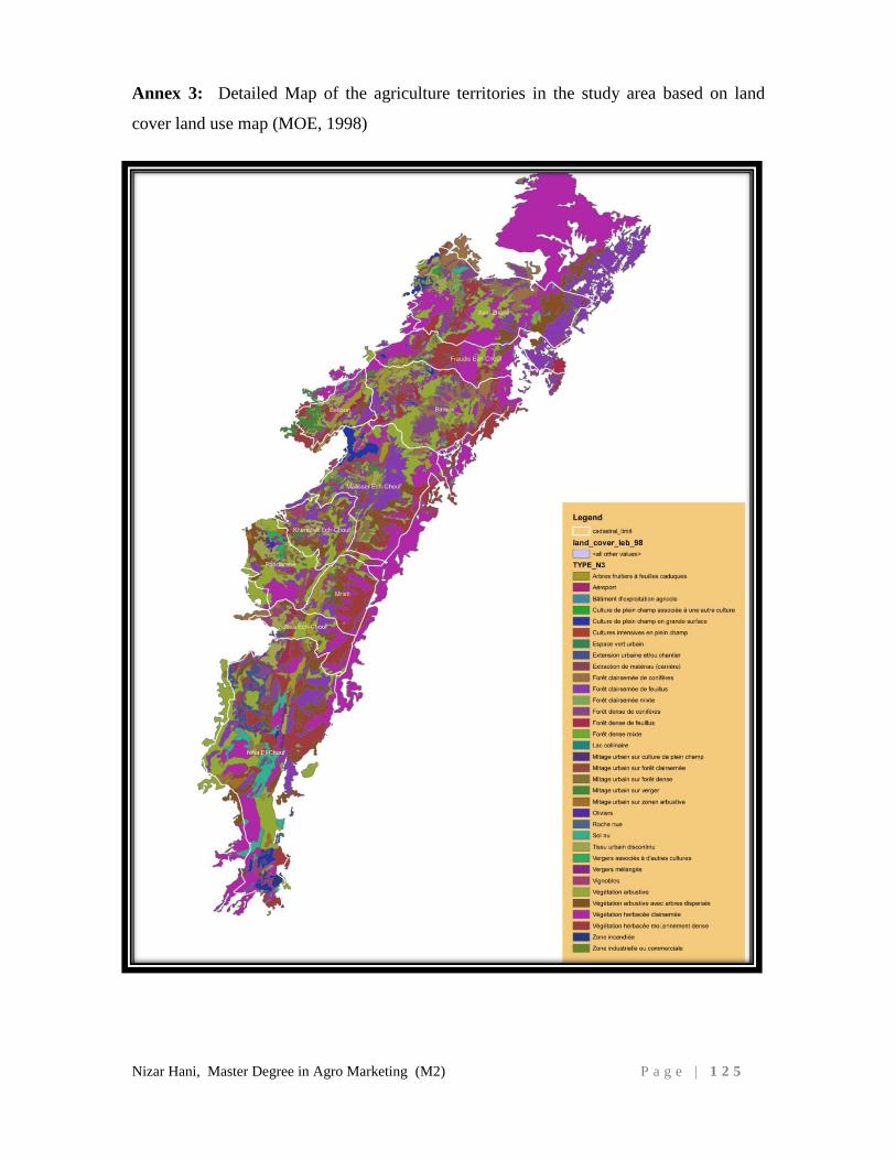
Nizar Hani, Master Degree in Agro Marketing (M2) P a g e | 1 2 5
Annex 3: Detailed Map of the agriculture territories in the study area based on land
cover land use map (MOE, 1998)
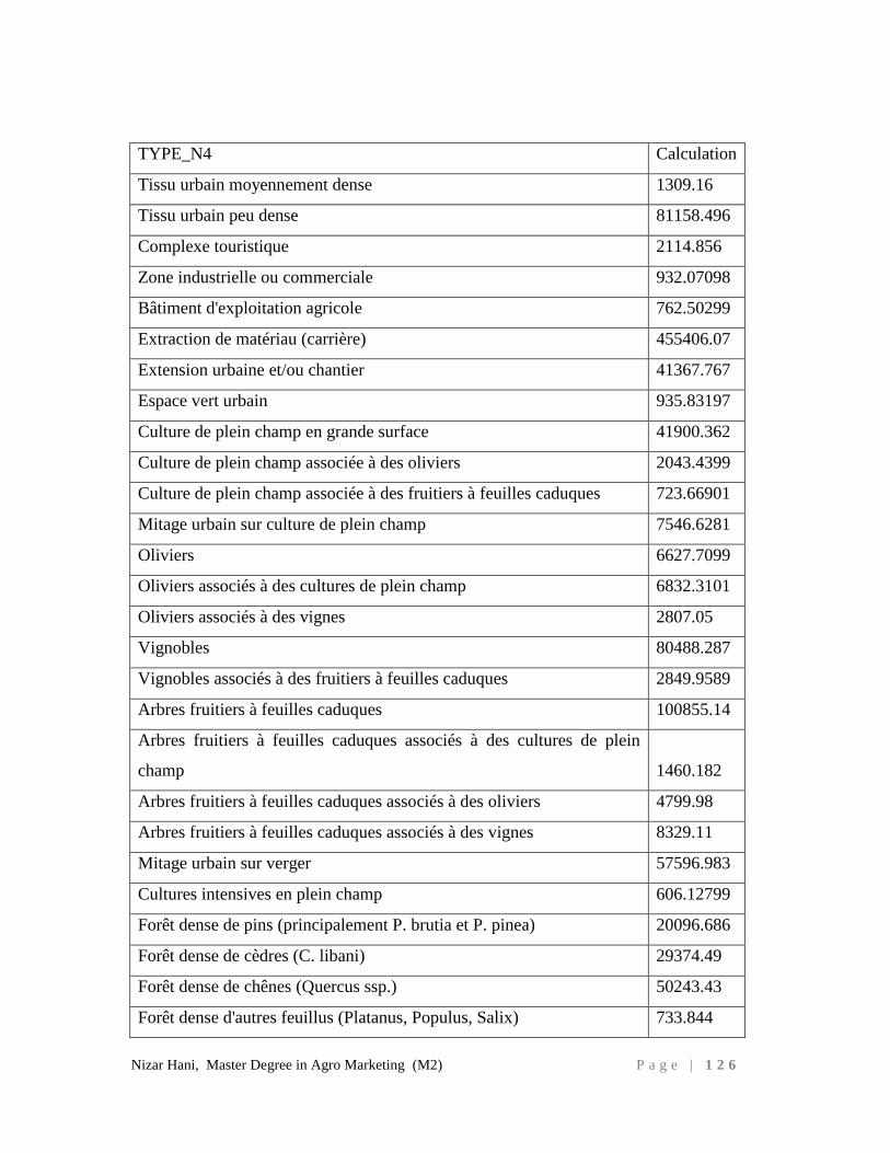
Nizar Hani, Master Degree in Agro Marketing (M2) P a g e | 1 2 6
TYPE_N4 Calculation
Tissu urbain moyennement dense 1309.16
Tissu urbain peu dense 81158.496
Complexe touristique 2114.856
Zone industrielle ou commerciale 932.07098
Bâtiment d'exploitation agricole 762.50299
Extraction de matériau (carrière) 455406.07
Extension urbaine et/ou chantier 41367.767
Espace vert urbain 935.83197
Culture de plein champ en grande surface 41900.362
Culture de plein champ associée à des oliviers 2043.4399
Culture de plein champ associée à des fruitiers à feuilles caduques 723.66901
Mitage urbain sur culture de plein champ 7546.6281
Oliviers 6627.7099
Oliviers associés à des cultures de plein champ 6832.3101
Oliviers associés à des vignes 2807.05
Vignobles 80488.287
Vignobles associés à des fruitiers à feuilles caduques 2849.9589
Arbres fruitiers à feuilles caduques 100855.14
Arbres fruitiers à feuilles caduques associés à des cultures de plein
champ 1460.182
Arbres fruitiers à feuilles caduques associés à des oliviers 4799.98
Arbres fruitiers à feuilles caduques associés à des vignes 8329.11
Mitage urbain sur verger 57596.983
Cultures intensives en plein champ 606.12799
Forêt dense de pins (principalement P. brutia et P. pinea) 20096.686
Forêt dense de cèdres (C. libani) 29374.49
Forêt dense de chênes (Quercus ssp.) 50243.43
Forêt dense d'autres feuillus (Platanus, Populus, Salix) 733.844
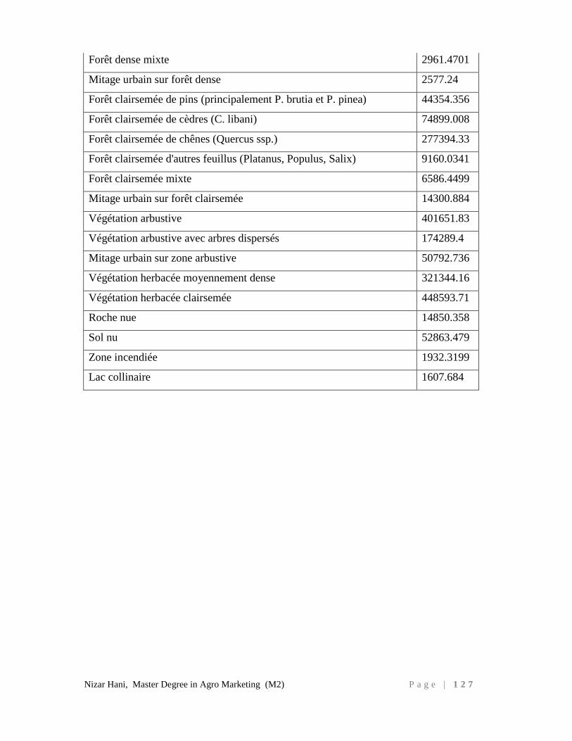
Nizar Hani, Master Degree in Agro Marketing (M2) P a g e | 1 2 7
Forêt dense mixte 2961.4701
Mitage urbain sur forêt dense 2577.24
Forêt clairsemée de pins (principalement P. brutia et P. pinea) 44354.356
Forêt clairsemée de cèdres (C. libani) 74899.008
Forêt clairsemée de chênes (Quercus ssp.) 277394.33
Forêt clairsemée d'autres feuillus (Platanus, Populus, Salix) 9160.0341
Forêt clairsemée mixte 6586.4499
Mitage urbain sur forêt clairsemée 14300.884
Végétation arbustive 401651.83
Végétation arbustive avec arbres dispersés 174289.4
Mitage urbain sur zone arbustive 50792.736
Végétation herbacée moyennement dense 321344.16
Végétation herbacée clairsemée 448593.71
Roche nue 14850.358
Sol nu 52863.479
Zone incendiée 1932.3199
Lac collinaire 1607.684
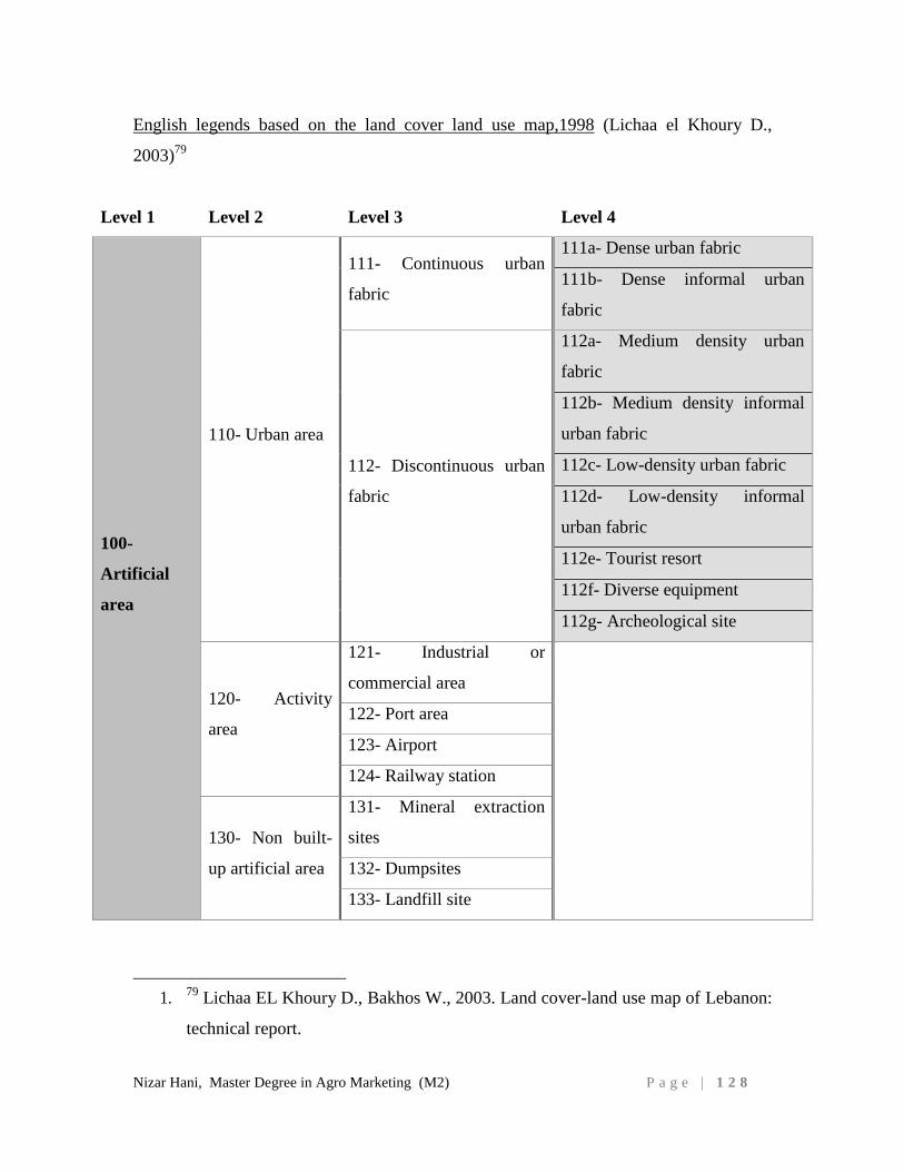
Nizar Hani, Master Degree in Agro Marketing (M2) P a g e | 1 2 8
English legends based on the land cover land use map,1998 (Lichaa el Khoury D.,
2003)79
Level 1 Level 2 Level 3 Level 4
100-
Artificial
area
110- Urban area
111- Continuous urban
fabric
111a- Dense urban fabric
111b- Dense informal urban
fabric
112- Discontinuous urban
fabric
112a- Medium density urban
fabric
112b- Medium density informal
urban fabric
112c- Low-density urban fabric
112d- Low-density informal
urban fabric
112e- Tourist resort
112f- Diverse equipment
112g- Archeological site
120- Activity
area
121- Industrial or
commercial area
122- Port area
123- Airport
124- Railway station
130- Non built-
up artificial area
131- Mineral extraction
sites
132- Dumpsites
133- Landfill site
1. 79 Lichaa EL Khoury D., Bakhos W., 2003. Land cover-land use map of Lebanon:
technical report.
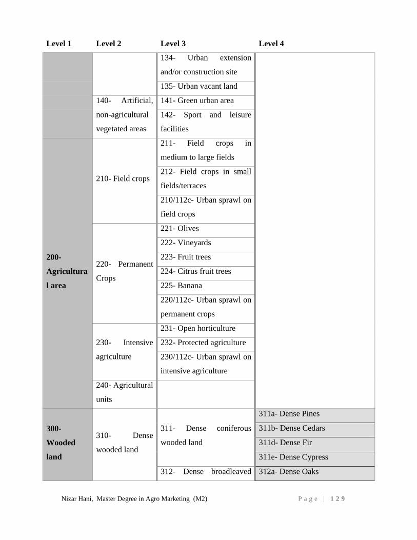
Nizar Hani, Master Degree in Agro Marketing (M2) P a g e | 1 2 9
Level 1 Level 2 Level 3 Level 4
134- Urban extension
and/or construction site
135- Urban vacant land
140- Artificial,
non-agricultural
vegetated areas
141- Green urban area
142- Sport and leisure
facilities
200-
Agricultura
l area
210- Field crops
211- Field crops in
medium to large fields
212- Field crops in small
fields/terraces
210/112c- Urban sprawl on
field crops
220- Permanent
Crops
221- Olives
222- Vineyards
223- Fruit trees
224- Citrus fruit trees
225- Banana
220/112c- Urban sprawl on
permanent crops
230- Intensive
agriculture
231- Open horticulture
232- Protected agriculture
230/112c- Urban sprawl on
intensive agriculture
240- Agricultural
units
300-
Wooded
land
310- Dense
wooded land
311- Dense coniferous
wooded land
311a- Dense Pines
311b- Dense Cedars
311d- Dense Fir
311e- Dense Cypress
312- Dense broadleaved 312a- Dense Oaks
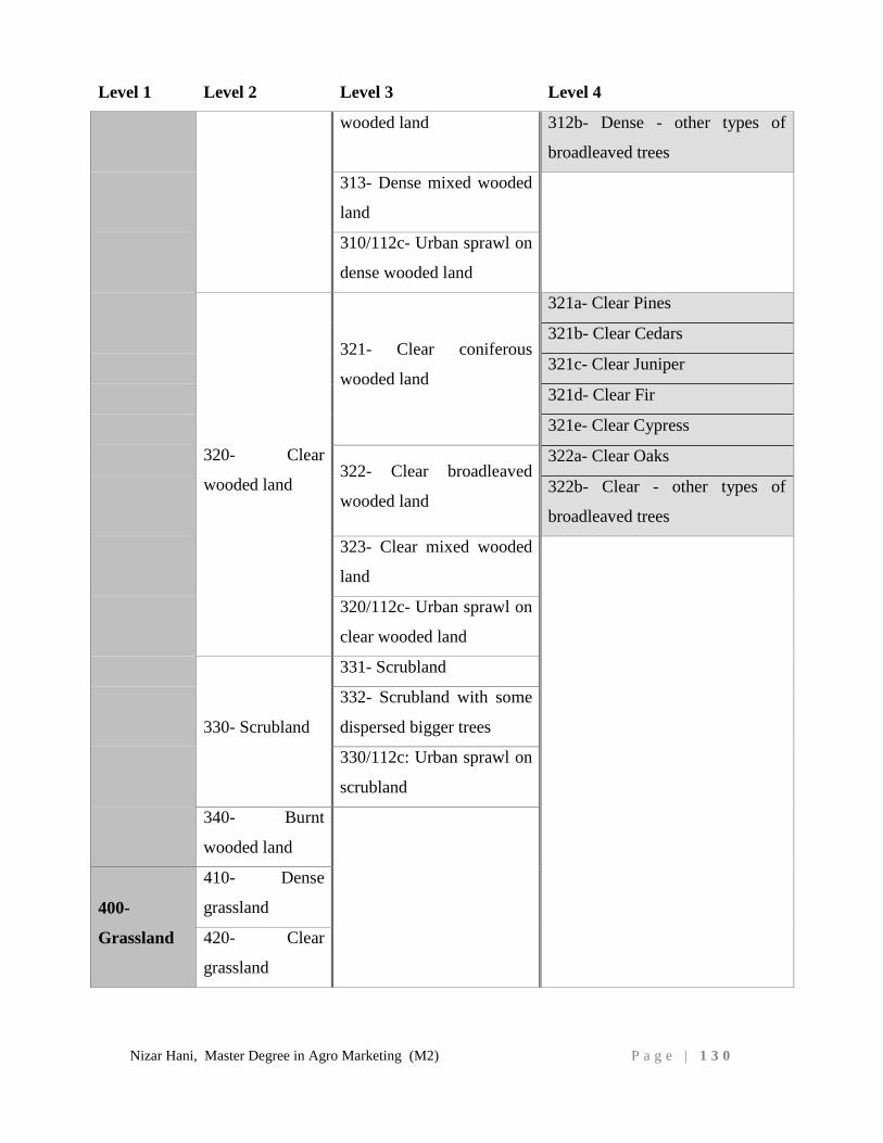
Nizar Hani, Master Degree in Agro Marketing (M2) P a g e | 1 3 0
Level 1 Level 2 Level 3 Level 4
wooded land 312b- Dense - other types of
broadleaved trees
313- Dense mixed wooded
land
310/112c- Urban sprawl on
dense wooded land
320- Clear
wooded land
321- Clear coniferous
wooded land
321a- Clear Pines
321b- Clear Cedars
321c- Clear Juniper
321d- Clear Fir
321e- Clear Cypress
322- Clear broadleaved
wooded land
322a- Clear Oaks
322b- Clear - other types of
broadleaved trees
323- Clear mixed wooded
land
320/112c- Urban sprawl on
clear wooded land
330- Scrubland
331- Scrubland
332- Scrubland with some
dispersed bigger trees
330/112c: Urban sprawl on
scrubland
340- Burnt
wooded land
400-
Grassland
410- Dense
grassland
420- Clear
grassland
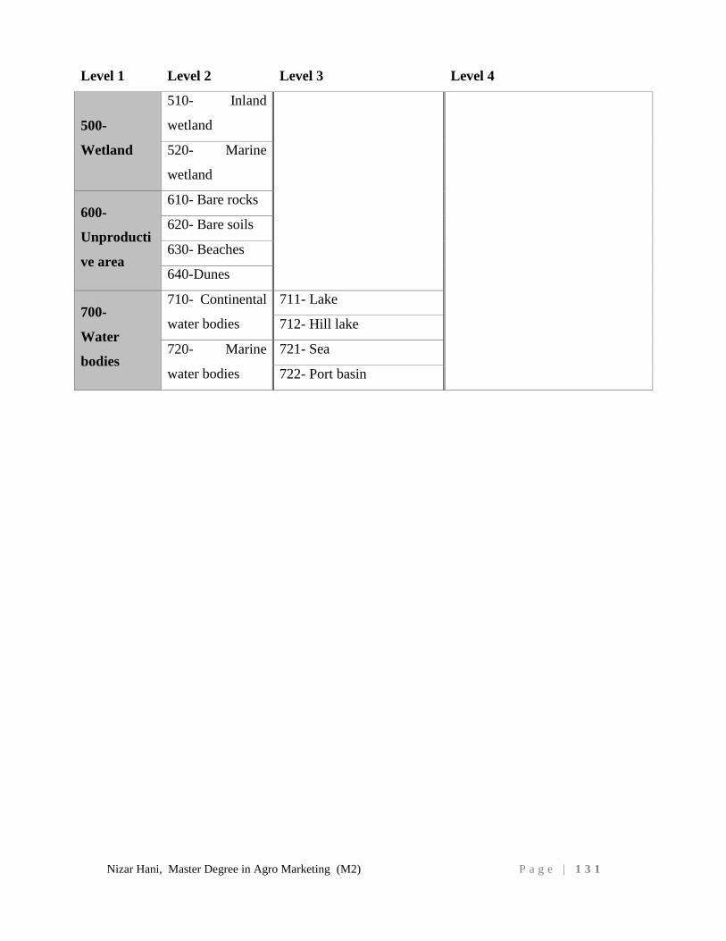
Nizar Hani, Master Degree in Agro Marketing (M2) P a g e | 1 3 1
Level 1 Level 2 Level 3 Level 4
500-
Wetland
510- Inland
wetland
520- Marine
wetland
600-
Unproducti
ve area
610- Bare rocks
620- Bare soils
630- Beaches
640-Dunes
700-
Water
bodies
710- Continental
water bodies
711- Lake
712- Hill lake
720- Marine
water bodies
721- Sea
722- Port basin
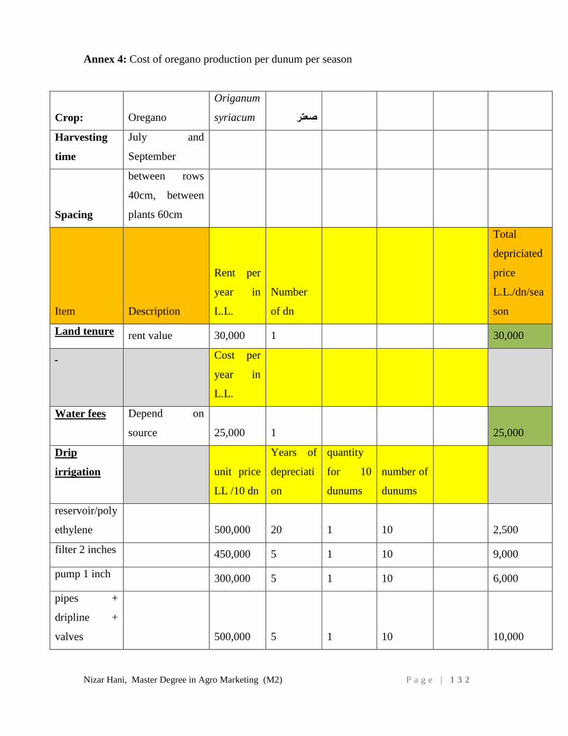
Nizar Hani, Master Degree in Agro Marketing (M2) P a g e | 1 3 2
Annex 4: Cost of oregano production per dunum per season
Crop: Oregano
Origanum
syriacum صعتر
Harvesting
time
July and
September
Spacing
between rows
40cm, between
plants 60cm
Item Description
Rent per
year in
L.L.
Number
of dn
Total
depriciated
price
L.L./dn/sea
son
Land tenure rent value 30,000 1 30,000
Cost per
year in
L.L.
Water fees Depend on
source 25,000 1 25,000
Drip
irrigation
unit price
LL /10 dn
Years of
depreciati
on
quantity
for 10
dunums
number of
dunums
reservoir/poly
ethylene
500,000 20 1 10 2,500
filter 2 inches 450,000 5 1 10 9,000
pump 1 inch 300,000 5 1 10 6,000
pipes +
dripline +
valves 500,000 5 1 10 10,000
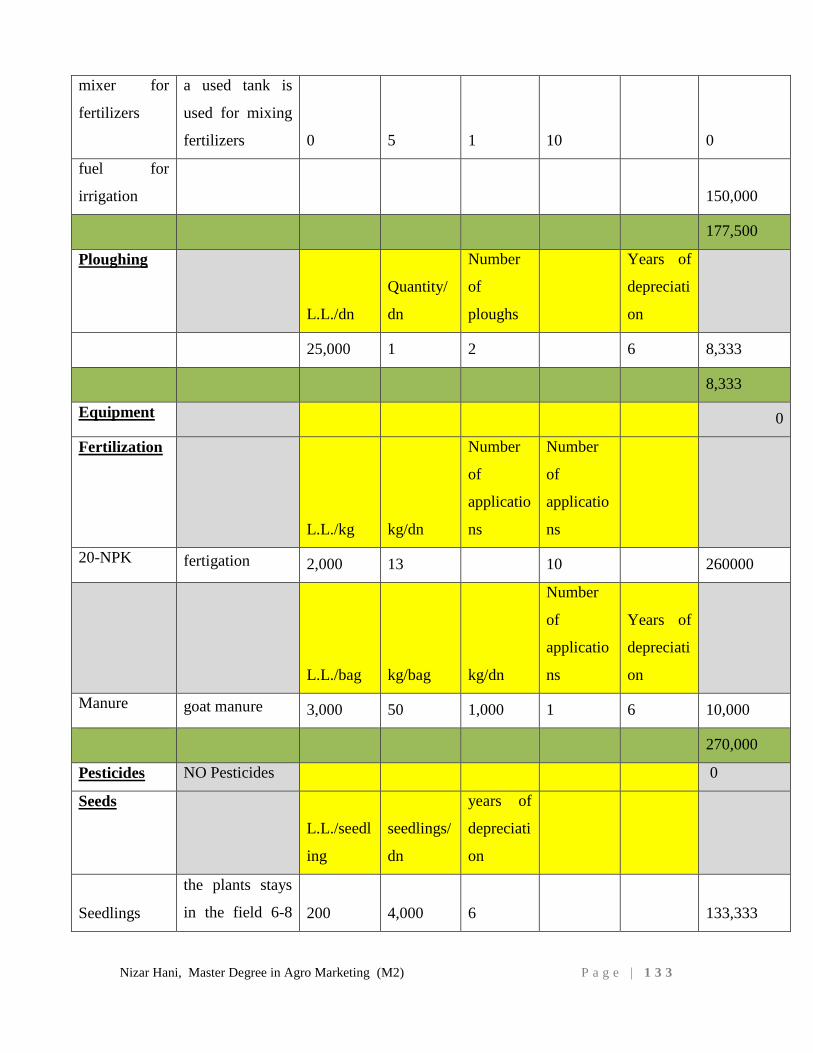
Nizar Hani, Master Degree in Agro Marketing (M2) P a g e | 1 3 3
mixer for
fertilizers
a used tank is
used for mixing
fertilizers 0 5 1 10 0
fuel for
irrigation 150,000
177,500
Ploughing
L.L./dn
Quantity/
dn
Number
of
ploughs
Years of
depreciati
on
25,000 1 2 6 8,333
8,333
Equipment 0
Fertilization
L.L./kg kg/dn
Number
of
applicatio
ns
Number
of
applicatio
ns
20-NPK fertigation 2,000 13 10 260000
L.L./bag kg/bag kg/dn
Number
of
applicatio
ns
Years of
depreciati
on
Manure goat manure 3,000 50 1,000 1 6 10,000
270,000
Pesticides NO Pesticides 0
Seeds
L.L./seedl
ing
seedlings/
dn
years of
depreciati
on
Seedlings
the plants stays
in the field 6-8 200 4,000 6 133,333
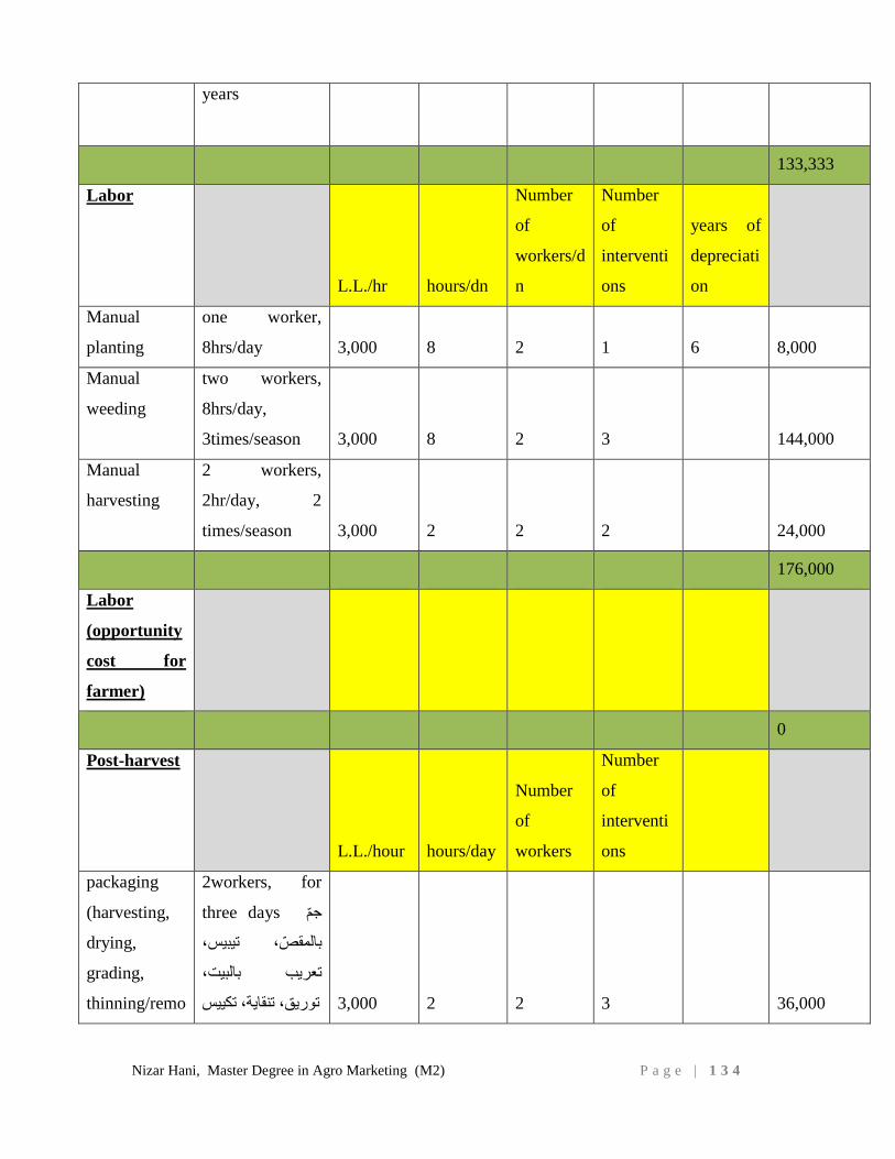
Nizar Hani, Master Degree in Agro Marketing (M2) P a g e | 1 3 4
years
133,333
Labor
L.L./hr hours/dn
Number
of
workers/d
n
Number
of
interventi
ons
years of
depreciati
on
Manual
planting
one worker,
8hrs/day 3,000 8 2 1 6 8,000
Manual
weeding
two workers,
8hrs/day,
3times/season 3,000 8 2 3 144,000
Manual
harvesting
2 workers,
2hr/day, 2
times/season 3,000 2 2 2 24,000
176,000
Labor
(opportunity
cost for
farmer)
0
Post-harvest
L.L./hour hours/day
Number
of
workers
Number
of
interventi
ons
packaging
(harvesting,
drying,
grading,
thinning/remo
2workers, for
three days جّم
بالمقّص، تيبيس،
تعريب بالبيت،
36,000 3 2 2 3,000 توريق، تنقاية، تكييس
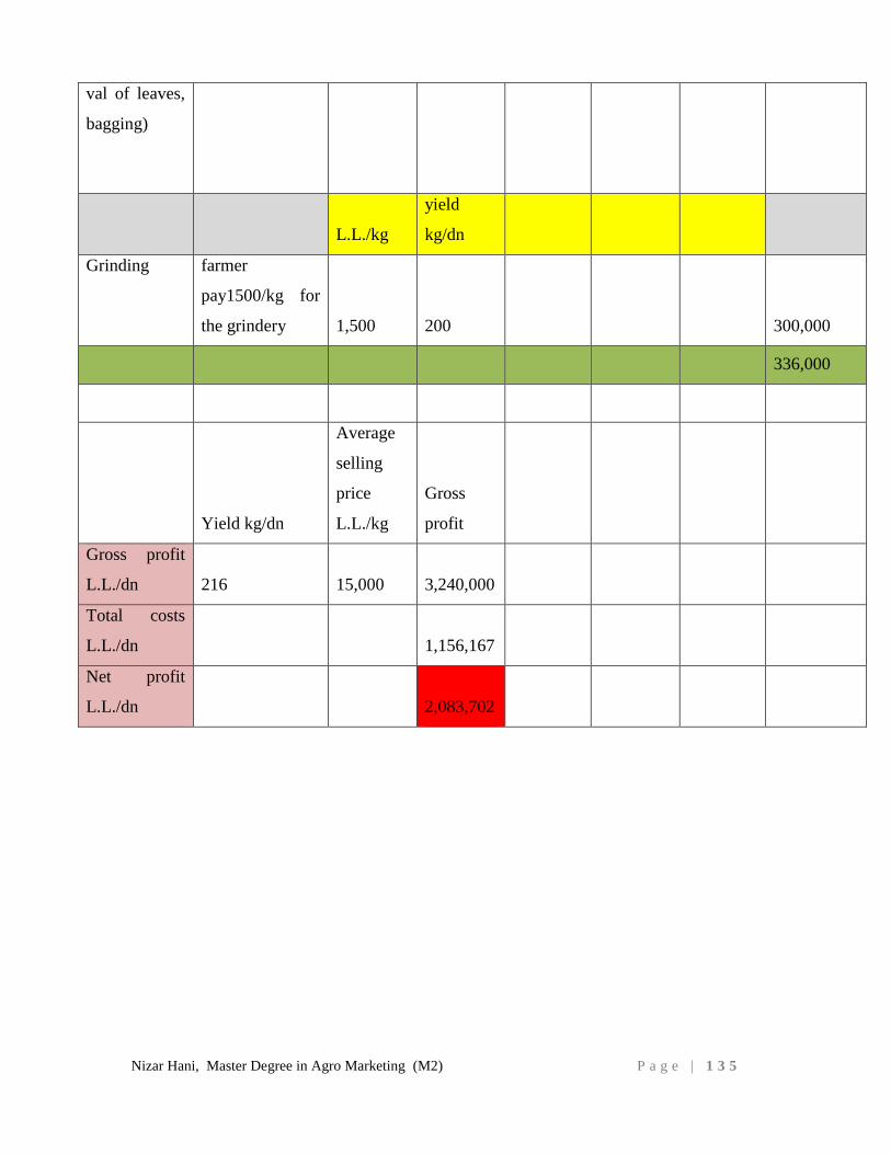
Nizar Hani, Master Degree in Agro Marketing (M2) P a g e | 1 3 5
val of leaves,
bagging)
L.L./kg
yield
kg/dn
Grinding farmer
pay1500/kg for
the grindery 1,500 200 300,000
336,000
Yield kg/dn
Average
selling
price
L.L./kg
Gross
profit
Gross profit
L.L./dn 216 15,000 3,240,000
Total costs
L.L./dn 1,156,167
Net profit
L.L./dn 2,083,702