Preliminary UAS Weather Research Roadmap
62
Lincoln Laboratory MASSACHUSETTS INSTITUTE OF TECHNOLOGY LEXINGTON, MASSACHUSETTS Project Report ATC-438 Revision 1 Preliminary UAS Weather Research Roadmap 23 October 2017 Revised 3 November 2017 Prepared for the Federal Aviation Administration, Washington, DC 20591 This document is available to the public through the National Technical Information Service, Springfield, Virginia 22161 S. Campbell D.A. Clark J.E. Evans
Transcript of Preliminary UAS Weather Research Roadmap
Lincoln Laboratory MASSACHUSETTS INSTITUTE OF TECHNOLOGY
LEXINGTON, MASSACHUSETTS
Project Report ATC-438
Revision 1
Preliminary UAS Weather Research Roadmap
23 October 2017 Revised 3 November 2017
Prepared for the Federal Aviation Administration, Washington, DC 20591
This document is available to the public through the National Technical Information Service,
Springfield, Virginia 22161
S. CampbellD.A. ClarkJ.E. Evans

This material is based upon work supported by the Federal Aviation Administration (FAA) under Air Force Contract No. FA8721-05-C-0002 and/or FA8702-15-D-0001. Any opinions, findings, conclusions or recommendations expressed in this material are those of the author(s) and do not necessarily reflect the views of the FAA.
© 2017 MASSACHUSETTS INSTITUTE OF TECHNOLOGY
Delivered to the U.S. Government with Unlimited Rights, as defined in DFARS Part 252.227-7013 or 7014 (Feb 2014). Notwithstanding any copyright notice, U.S. Government rights in this work are defined by DFARS 252.227-7013 or DFARS 252.227-7014 as detailed above. Use of this work other than as specifically authorized by the U.S. Government may violate any copyrights that exist in this work.
17. Key Words 18. Distribution Statement
19. Security Classif. (of this report) 20. Security Classif. (of this page) 21. No. of Pages 22. Price
TECHNICAL REPORT STANDARD TITLE PAGE
1. Report No. 2. Government Accession No. 3. Recipient's Catalog No.
4. Title and Subtitle 5. Report Date
6. Performing Organization Code
7. Author(s) 8. Performing Organization Report No.
9. Performing Organization Name and Address 10. Work Unit No. (TRAIS)
11. Contract or Grant No.
12. Sponsoring Agency Name and Address 13. Type of Report and Period Covered
14. Sponsoring Agency Code
15. Supplementary Notes
16. Abstract
. and/or
Unclassified Unclassified 60
FORM DOT F 1700.7 (8-72) Reproduction of completed page authorized
S. Campbell, D.A. Clark, J.E. Evans
MIT Lincoln Laboratory244 Wood StreetLexington, MA 02421
This report is based on studies performed at Lincoln Laboratory, a federally funded research and development center operatedby Massachusetts Institute of Technology, under Air Force Contract FA8721-05-C-0002 and/or FA8702-15-D-0001.
Approved for public release: distribution unlimited.
ATC-438 Revision 1
Preliminary UAS Weather Research Roadmap
Department of TransportationFederal Aviation Administration800 Independence Ave., S.W.Washington, DC 20591
Project Report
ATC-438 Revision 1
3 November 2017
Unmanned Aircraft System (UAS) operations in the National Airspace System (NAS) are rapidly increasing, and the trend is expected to continue as regulations are refined to allow broader access to the airspace. The unique characteristics of UAS (e.g., extensive operations in populated areas at altitudes below 500 feet, speed capability, and control systems) may drive the need for new and unique operational strategies, many of which are highly dependent on weather conditions.
A companion Lincoln Laboratory report (ATC-437, “Preliminary Weather Information Gaps for UAS Operations”) identified initial gaps in the ability of current weather products to meet the needs of UAS operations. As discussed in that report, there are several trends in the information gaps that surfaced repeatedly. A key item was the availability of weather observations and forecasts tailored for on-airport operations that are not necessarily sufficient for off-airport operations. Surveyed users indicated that airport-specific weather information (e.g., METAR, TAFs, etc.) do not readily translate to conditions at remote launch locations, which may be 10–30 miles from the nearest airport, and are influenced by local terrain, vegetation, and water sources. Moreover, the results show that significantly less weather information is available to support low-altitude flight than for typical manned-flight profiles. Beyond Visual Line of Sight (BVLOS) operations were found to have higher need for weather forecasts, uncertainty information, and contingency planning than Visual Line of Sight (VLOS) operations. Furthermore, the study identified specific gaps related to how the airspace should be managed to mitigate safety and efficiency impacts to UAS operations.
Building off of that work, this report summarizes the development of a proposed initial roadmap for research to fill the gaps that were identified. The research roadmap presented here is composed of research recommendations that are derived from the identified weather information gaps. In total, there are 14 specific recommendations that define the roadmap. The first two recommendations are not explicitly tied to specific gaps; rather they are based on lessons learned through the course of research in this study. The remaining recommendations are provided in priority order based on their overall significance to the operation, the maturity of the operation, and any dependence among other recommendations.
FA8721-05-C-0002 and/or FA8702-15-D-0001

This page intentionally left blank.
i
ABSTRACT
Unmanned Aircraft System (UAS) operations in the National Airspace System (NAS) are rapidly increasing, and the trend is expected to continue as regulations are refined to allow broader access to the airspace. The unique characteristics of UAS (e.g., extensive operations in populated areas at altitudes below 500 feet, speed capability, and control systems) may drive the need for new and unique operational strategies, many of which are highly dependent on weather conditions.
A companion Lincoln Laboratory report (ATC-437, “Preliminary Weather Information Gaps for UAS Operations”) identified initial gaps in the ability of current weather products to meet the needs of UAS operations. As discussed in that report, there are several trends in the information gaps that surfaced repeatedly. A key item was the availability of weather observations and forecasts tailored for on-airport operations that are not necessarily sufficient for off-airport operations. Surveyed users indicated that airport-specific weather information (e.g., METAR, TAFs, etc.) do not readily translate to conditions at remote launch locations, which may be 10–30 miles from the nearest airport, and are influenced by local terrain, vegetation, and water sources. Moreover, the results show that significantly less weather information is available to support low-altitude flight than for typical manned-flight profiles. Beyond Visual Line of Sight (BVLOS) operations were found to have higher need for weather forecasts, uncertainty information, and contingency planning than Visual Line of Sight (VLOS) operations. Furthermore, the study identified specific gaps related to how the airspace should be managed to mitigate safety and efficiency impacts to UAS operations.
Building off of that work, this report summarizes the development of a proposed initial roadmap for research to fill the gaps that were identified. The research roadmap presented here is composed of research recommendations that are derived from the identified weather information gaps. In total, there are 14 specific recommendations that define the roadmap. The first two recommendations are not explicitly tied to specific gaps; rather they are based on lessons learned through the course of research in this study. The remaining recommendations are provided in priority order based on their overall significance to the operation, the maturity of the operation, and any dependence among other recommendations.

This page intentionally left blank.
iii
TABLE OF CONTENTS
Page
Abstract iList of Illustrations vList of Tables vii
1. INTRODUCTION 1
2. METHODOLOGY 3
3. WEATHER NEEDS FOR UAS OPERATIONS 5
3.1 VLOS Weather Needs 53.2 BVLOS Weather Needs 53.3 Weather Needs for Airspace Management 6
4. WEATHER INFORMATION GAPS 9
5. RESEARCH ROADMAP 15
5.1 Roadmap Research Recommendations 17
APPENDIX A MODIFICATION OF FAA WIND SHEAR PRODUCTS TO BETTER MEET UAS NEEDS FOR WARNINGS OF SUDDEN STRONG SURFACE WINDS 37
APPENDIX B
TECHNIQUES USED TO REDUCE OPERATIONAL IMPACTS OF LATENCY FOR WEATHER RADAR (E.G., NEXRAD) PROCESSING IN THE NEXGEN WEATHER PROCESSOR 43
Glossary 47References 49

This page intentionally left blank.
v
LIST OF ILLUSTRATIONS
Figure Page No.
1 Weather information gap identification process. 3
2 UAS weather research roadmap. 16
A1 Strong microburst (60 knot surface wind) outflow at Phoenix, AZ in July 2016. 37
A2 Virga descending from a cloud with a ring of dust at the surface generated by the outflow winds of a microburst 27 km east of Stapleton International Airport on 14 July 1982 (lower figure from [6]). The lower figure was obtained by Prof. T. Fujita [7]. 38
A3 Vertical cross section of the evolution of a microburst wind field, based on Denver area data [8]. T is the time of the initial divergence at the surface. The Shading refers to vector wind speeds. Note that the outflow depth typically extends well above the maximum altitude for low altitude UAS operations. 39
A4 Structure of a microburst “line”[11]. 40

This page intentionally left blank.
vii
LIST OF TABLES
Table Page No.
1 4
2 11
3 13
4 15
5
Weather Information Gap Scoring
Ranking of Weather Condition by Information Gap Score and Product Availability
Prioritized Ranking of Specific Weather Information Gaps
List of Weather Research Recommendations to Address Information Gaps
Mapping of Research Recommendations to Weather Information Gaps 17

This page intentionally left blank.
1
1. INTRODUCTION
Unmanned Aircraft System (UAS) operations in the National Airspace System (NAS) are rapidly increasing, and the trend is expected to continue as regulations are refined to allow broader access to the airspace.1 However, the system must maintain a high level of safety throughout its growth in order for the potential of UAS to be realized. Historically, weather has presented a significant hazard to all types of aviation, and weather products for manned aviation have evolved over time to reflect changing user needs. The unique characteristics of UAS (e.g., extensive operations in populated areas at altitudes below 500 feet, speed capability, and control systems) will require that existing aviation weather products be further refined to address differences between unmanned and manned operations.
The objective of this study is to identify information gaps in the ability of current weather products2 to meet the needs of UAS operations, and provide a roadmap of research required to fill the gaps. It is important to understand that not addressing the information gaps could delay or preclude the many unique benefits of UAS operations. For example, weather-induced safety incidents not only risk damage to people, property, and other aircraft, but they also degrade the public perception of UAS. Moreover, the life-saving benefits of certain first responder UAS missions are dependent on the ability of the mission to be completed in a variety of weather conditions. The goal of successful UAS integration is contingent on the ability of future airspace management strategies to remain both feasible and efficient in different weather situations.
The roadmap is intended to guide research and development to address the most significant weather information gaps. It details operations that may need additional weather support for safe and efficient operations, and identifies proposed research to close those gaps. High-level tasking and expected timeline to complete the research is provided.
The organization of this report is as follows. Section 2 introduces the methodology employed to identify and prioritize the research recommendations that compose the roadmap. Section 3 summarizes the findings of an earlier study on weather needs for UAS operators. Section 4 provides a prioritized list of weather information gaps in UAS operations, and Section 5 contains the research roadmap.
1 The 2016 FAA Aerospace Forecast suggests that more than 7 million small unmanned aircraft are expected to be purchased by 2020, with 2.5 million sales forecasted for 2016 alone. By 2020, the FAA projects that there will be 4.3 million aircraft flying for recreational purposes and 2.7 million flying for commercial reasons.
2 Examples of currently available weather information for UAS operators are the NWS Aviation Weather Center (AWC) website and commercial providers such as ForeFlight (https://www.foreflight.com/).

This page intentionally left blank.
3
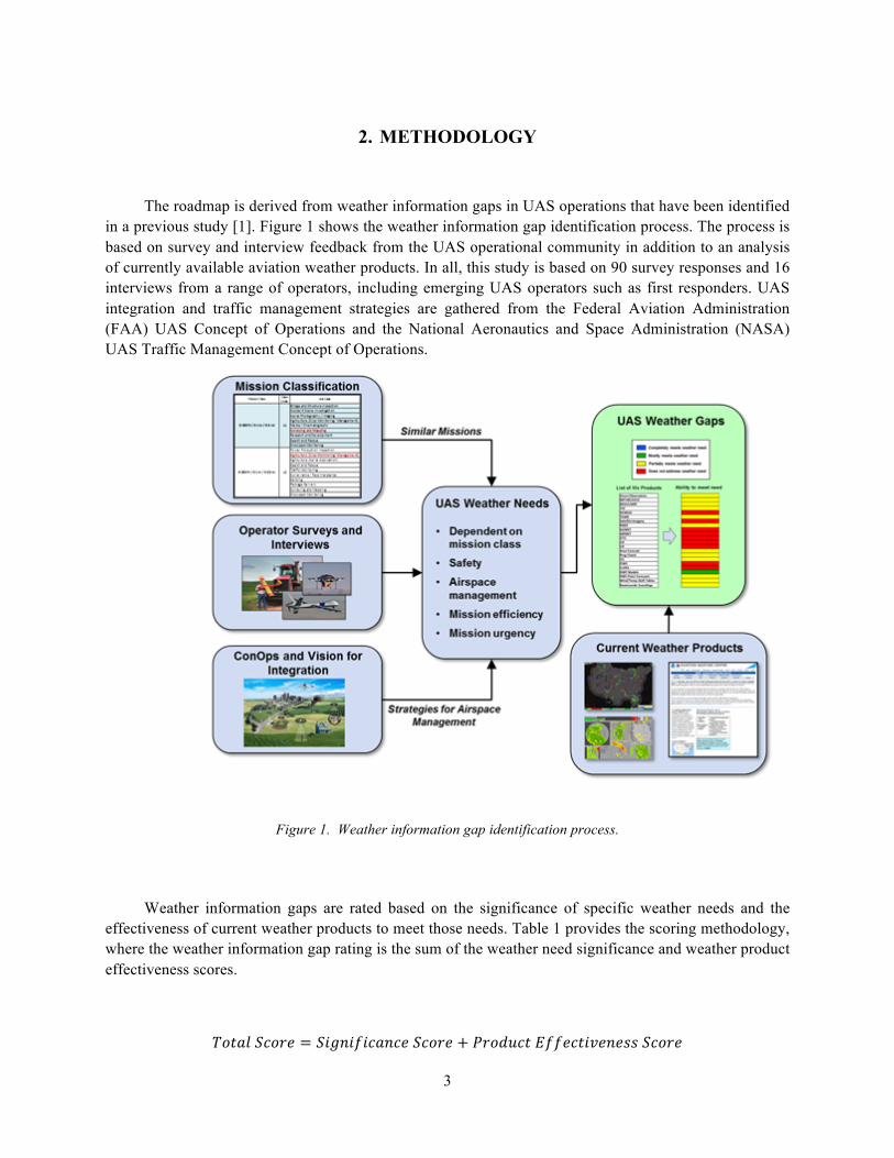
2. METHODOLOGY
The roadmap is derived from weather information gaps in UAS operations that have been identified in a previous study [1]. Figure 1 shows the weather information gap identification process. The process is based on survey and interview feedback from the UAS operational community in addition to an analysis of currently available aviation weather products. In all, this study is based on 90 survey responses and 16 interviews from a range of operators, including emerging UAS operators such as first responders. UAS integration and traffic management strategies are gathered from the Federal Aviation Administration (FAA) UAS Concept of Operations and the National Aeronautics and Space Administration (NASA) UAS Traffic Management Concept of Operations.
Figure 1. Weather information gap identification process.
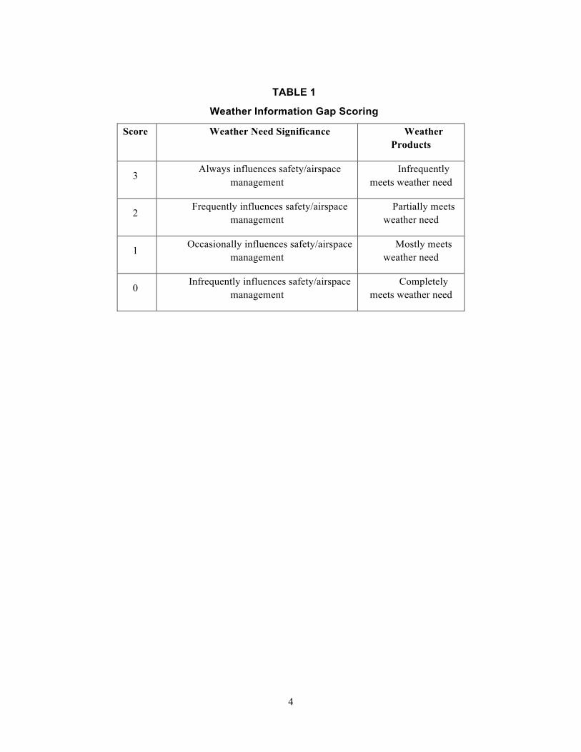
Weather information gaps are rated based on the significance of specific weather needs and the effectiveness of current weather products to meet those needs. Table 1 provides the scoring methodology, where the weather information gap rating is the sum of the weather need significance and weather product effectiveness scores.
!"#$%'(")* = ',-.,/,($.(*'(")* + 1)"23(#4//*(#,5*.*66'(")*
4
TABLE 1
Weather Information Gap Scoring
Score Weather Need Significance Weather Products
3 Always influences safety/airspace
management Infrequently
meets weather need
2 Frequently influences safety/airspace management
Partially meets weather need
1 Occasionally influences safety/airspace management
Mostly meets weather need
0 Infrequently influences safety/airspace management
Completely meets weather need
5
3. WEATHER NEEDS FOR UAS OPERATIONS
This section describes specific weather needs for different types of UAS operations. The weather needs are broken down into operational categories to summarize and consolidate the weather needs. The first category is Visual Line of Sight (VLOS) operations, which are predominately represented by small UAS missions. The next category, Beyond Visual Line of Sight (BVLOS) operations, are conducted by both small and large UAS. The Airspace Management category represents needs for defining weather-related airspace constraints to enable UAS integration in the NAS. A more detailed description of the weather needs is found in [1].
3.1 VLOS WEATHER NEEDS
The FAA has established small UAS operating rules (CFR Part 107) to guide VLOS operations. From a weather standpoint, the Part 107 rules require that the operator be aware of local weather conditions, only operate if the slant range visibility to the UAS is greater than 3 statute miles, and maintain cloud clearances of 500 feet below and 2000 feet horizontal distance from the clouds.
An interesting side effect of VLOS operations is that the operator is physically located at the mission site, where they can visually and tactically observe the local weather conditions. This allows the UAS operators to “ball-park” local weather conditions in making operational decisions. In general, survey respondents who conduct VLOS operations noted that they do not have an effective method to determine wind speed and direction above tree-level, or if they are operating in an urban environment or a location with complicated terrain. This was also true in making local visual estimates of ceiling height and visibility to conform to Part 107 regulations.
Wind gusts and turbulence can decrease flight endurance due to the additional flight control power necessary to maintain steady flight. Moreover, strong or gusty winds can overcome the ability of a small UAS to maintain position if the wind speed is greater than the forward speed capability of the UAS. Furthermore, UAS that conduct VLOS operations are not typically sealed to water, meaning that any precipitation can cause electrical failure. Lastly, UAS are susceptible to altitude errors if they utilize a pressure altimeter calibrated to ground level at launch to determine height above the landing site in lieu of a radar altimeter.
3.2 BVLOS WEATHER NEEDS
Small UAS are differentiated from large UAS by their size, but also by the typical altitude that they operate. Small UAS are envisioned to predominately occupy the low-altitude domain from the surface to 500 feet. Expected missions are focused on aerial imaging and include pipeline monitoring, search and rescue, firefighters, and transportation infrastructure inspection. The specific weather needs for small UAS BVLOS operations are as follows (in no particular order).
1. Turbulence/wind gusts can decrease battery performance, as well as interfere with the integrityof a satellite control and communications link.
6
2. Windshear and, more generally, strong outflows from thunderstorms can be very dangerous atlow altitude, especially for fixed-wing platforms, or if the winds exceed the available airspeedcapability of the UAS.
3. Barometric pressure changes can influence pressure altimeter calibration, and can be verydangerous at low altitude if a radar altimeter is not installed on the UAS.
4. Icing can build on a small airframe or propeller much faster than on a conventional aircraft.
5. Low temperatures have been shown to decrease battery life, and in turn, mission endurance.
On the other hand, a large UAS has the potential to operate at very high altitudes (FL600) and for very long mission durations (30+ hours). Turbulence is a great concern to large UAS operators due to its effect on the control and communications link. The unsteadiness caused by turbulence can destabilize the SATCOM and interfere with communications. Many of the large UAS platforms are not equipped with deicing capabilities and are therefore susceptible to icing on departure and arrival. Because large UAS typically operate off of runways, they are sensitive to winds direction due to the very conservative crosswind limits of the UAS platforms. Lastly, because the large UAS typically operate at high-altitude, they have the ability to fly over convective weather as long as they know the height of the cloud tops.
All classes of UAS are affected by winds aloft. The accuracy of winds aloft is critical to flight planning and the feasibility of time-based integration strategies. Small UAS that have a slow cruising speed can be overwhelmed by winds greater than 20 knots. Moreover, BVLOS operations require very strict contingency planning to ensure that a feasible lost-link path is available if the UAS loses communication or control. Weather forecast uncertainty significantly impacts lost-link contingency planning due to the need to avoid the safety problems that arise with lost-link coupled with the need to avoid overly conservative assessments of weather impact. More effective contingency planning would be possible if there were validated weather uncertainty information that could be used for risk-based planning.
3.3 WEATHER NEEDS FOR AIRSPACE MANAGEMENT
Airspace management is a critical component of UAS integration. Both NASA and the FAA have developed visions for integration, where the NASA effort is focused on small UAS whereas the FAA considers the entire spectrum of UAS. Airspace management comes in many forms and different levels of complexity:
1. The most basic form of airspace management is the static geofence, which effectivelycreates virtual barrier to preclude flight into certain areas. From a weather standpoint, astatic geofence can be defined around an area of severe weather, but it is important tounderstand that different UAS types have different weather sensitivities that correspond todifference geofence boundaries. Moreover, static geofences do not capture the dynamicnature of weather, and in turn, can be a very conservative approach to airspacemanagement.
2. Dynamic geofences can move with weather or surround a UAS along the planned route of flightto ensure aircraft separation. A benefit to a dynamic geofence is that it is more efficient for use
7
in flight or contingency planning. However, the usefulness of a dynamic geofence is only as good as the weather forecasts supporting it (both spatially and temporally).
2. Time-based operations are expected to be an important strategy for UAS integration in whichUAS plan and fly a 4-dimensional route to define time-on-waypoint so that flight plans areseparated from other aircraft. Accurate winds aloft information are critical to achieve time-based operations. Other weather elements can also impact time-based operations, and thepermeability of weather (e.g., icing or convective weather tolerance) is largely dependent on thetype of UAS being considered.
3. As the number of UAS in the airspace increases, demand and capacity balancing may benecessary to effectively allocate UAS flights to the airspace. Airspace capacity models forweather constrained airspace may eventually be needed to estimate and forecast the impact ofweather on a heterogeneous mixture of UAS platforms.

This page intentionally left blank.
9
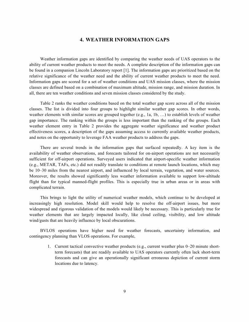
4. WEATHER INFORMATION GAPS
Weather information gaps are identified by comparing the weather needs of UAS operators to the ability of current weather products to meet the needs. A complete description of the information gaps can be found in a companion Lincoln Laboratory report [1]. The information gaps are prioritized based on the relative significance of the weather need and the ability of current weather products to meet the need. Information gaps are scored for a set of weather conditions and UAS mission classes, where the mission classes are defined based on a combination of maximum altitude, mission range, and mission duration. In all, there are ten weather conditions and seven mission classes considered by the study.
Table 2 ranks the weather conditions based on the total weather gap score across all of the mission classes. The list is divided into four groups to highlight similar weather gap scores. In other words, weather elements with similar scores are grouped together (e.g., 1a, 1b, …) to establish levels of weather gap importance. The ranking within the groups is less important than the ranking of the groups. Each weather element entry in Table 2 provides the aggregate weather significance and weather product effectiveness scores, a description of the gaps assuming access to currently available weather products, and notes on the opportunity to leverage FAA weather products to address the gaps.
There are several trends in the information gaps that surfaced repeatedly. A key item is the availability of weather observations, and forecasts tailored for on-airport operations are not necessarily sufficient for off-airport operations. Surveyed users indicated that airport-specific weather information (e.g., METAR, TAFs, etc.) did not readily translate to conditions at remote launch locations, which may be 10–30 miles from the nearest airport, and influenced by local terrain, vegetation, and water sources. Moreover, the results showed significantly less weather information available to support low-altitude flight than for typical manned-flight profiles. This is especially true in urban areas or in areas with complicated terrain.
This brings to light the utility of numerical weather models, which continue to be developed at increasingly high resolution. Model skill would help to resolve the off-airport issues, but more widespread and rigorous validation of the models would likely be necessary. This is particularly true for weather elements that are largely impacted locally, like cloud ceiling, visibility, and low altitude wind/gusts that are heavily influence by local obscurations.
BVLOS operations have higher need for weather forecasts, uncertainty information, and contingency planning than VLOS operations. For example,
1. Current tactical convective weather products (e.g., current weather plus 0–20 minute short-term forecasts) that are readily available to UAS operators currently often lack short-termforecasts and can give an operationally significant erroneous depiction of current stormlocations due to latency.

10
2. FAA conventional aircraft tactical weather products (current weather situation with 0–2hour forecasts that include quantitative information on forecast accuracy as well as 20minute precipitation and gust front forecasts) are not readily available to UAS operators,and
3. Strategic convective weather products lack precision, especially at long forecast horizons,and do not provide sufficient uncertainty information to support contingency planning.
Moreover, winds aloft products do not provide information to support low-altitude or super high-altitude operations. Similarly, turbulence forecasts and models are not designed to support low-altitude or super high-altitude operations, which has an impact on UAS that rely on a satellite communications link. Lastly, icing is a relatively rare event, but can have a catastrophic impact on flight safety, especially for small UAS. Icing prediction models lack uncertainty information necessary for contingency planning and may not be designed to properly reflect the icing risk to small UAS.
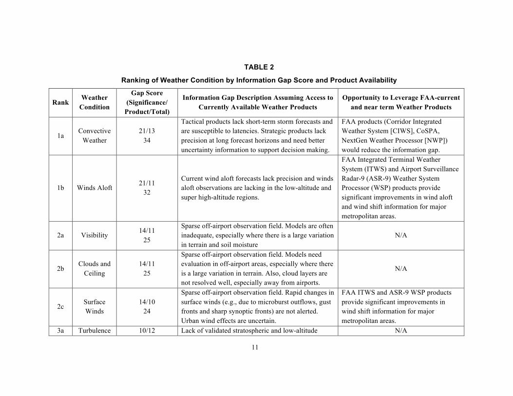
11
TABLE 2
Ranking of Weather Condition by Information Gap Score and Product Availability
Rank Weather
Condition
Gap Score (Significance/
Product/Total)
Information Gap Description Assuming Access to Currently Available Weather Products
Opportunity to Leverage FAA-current and near term Weather Products
1a Convective
Weather 21/13
34
Tactical products lack short-term storm forecasts and are susceptible to latencies. Strategic products lack precision at long forecast horizons and need better uncertainty information to support decision making.
FAA products (Corridor Integrated Weather System [CIWS], CoSPA, NextGen Weather Processor [NWP]) would reduce the information gap.
1b Winds Aloft 21/11
32
Current wind aloft forecasts lack precision and winds aloft observations are lacking in the low-altitude and super high-altitude regions.
FAA Integrated Terminal Weather System (ITWS) and Airport Surveillance Radar-9 (ASR-9) Weather System Processor (WSP) products provide significant improvements in wind aloft and wind shift information for major metropolitan areas.
2a Visibility 14/11
25
Sparse off-airport observation field. Models are often inadequate, especially where there is a large variation in terrain and soil moisture
N/A
2b Clouds and
Ceiling 14/11
25
Sparse off-airport observation field. Models need evaluation in off-airport areas, especially where there is a large variation in terrain. Also, cloud layers are not resolved well, especially away from airports.
N/A
2c Surface Winds
14/10 24
Sparse off-airport observation field. Rapid changes in surface winds (e.g., due to microburst outflows, gust fronts and sharp synoptic fronts) are not alerted. Urban wind effects are uncertain.
FAA ITWS and ASR-9 WSP products provide significant improvements in wind shift information for major metropolitan areas.
3a Turbulence 10/12 Lack of validated stratospheric and low-altitude N/A
12
Rank Weather
Condition
Gap Score (Significance/
Product/Total)
Information Gap Description Assuming Access to Currently Available Weather Products
Opportunity to Leverage FAA-current and near term Weather Products
22 turbulence information. Models not calibrated for small UAS. Forecasts lack uncertainty element.
3b Icing 11/11
22
Ice will build up faster on a small airframe. Models not calibrated for small UAS. Models do not account for “cold soak.” Forecasts lack uncertainty element.
N/A
3c Precipitation 11/7 18
Only significant for small UAS. FAA products (CIWS, CoSPA, NWP) would reduce the weather gap.
4a Temperature 7/5 12
No significant gaps identified. N/A
4b Barometric
Pressure 6/4 10
No significant gaps identified. N/A
13
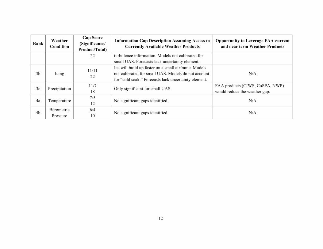
Airspace management strategies are also affected by the weather information gaps. For example, low-altitude time-based operations require validated winds aloft models and forecasts below 500 feet. Additionally, the feasibility of time-based operations (e.g., time-based metering for UAS) depends on an understanding of UAS weather impact models that are highly dependent on UAS type. Weather-based geofences will require similar UAS weather impact models for a spectrum of UAS platforms and weather conditions.
Table 3 distills the information in Table 2 into 12 specific weather information gaps that are prioritized based on current operational need. The information gaps listed in Table 3 are the basis for the research roadmap. The ranking of the gaps listed in Table 3 is generated from the ranking of the weather conditions in Table 2, but also the maturity of the operation that the gap affects. For example, consider two gaps that are scored equally in Table 2. If one of the gaps influences VLOS operations and the other affects BVLOS operations, the VLOS gap will be prioritized higher than the BVLOS gap because VLOS operations are currently more mature and common than BVLOS operations.
TABLE 3
Prioritized Ranking of Specific Weather Information Gaps
Weather Information Gap Impacted UAS Operation
1 Numerical weather model performance is uncertain, especially where there is a large variation in terrain
All UAS missions, especially in the low-altitude domain
2 No mechanism to alert operators to rapid changes in winds (e.g., due to microburst outflows, gust fronts and sharp synoptic fronts)
Primarily small UAS operations
3 Off-airport weather observations (visibility, ceiling, wind) are sparse
All UAS missions that operate off-airport, especially VLOS operations (Part 107)
4 Tactical convective weather products lack short-term storm forecasts and are susceptible to latencies
Primarily BVLOS missions for UAS without onboard weather radar
5 Current wind aloft forecasts lack precision and winds aloft observations are lacking in the low-altitude and super high-altitude regions
Primarily BVLOS mission planning, especially for time-based operations
6 Strategic convective weather products lack precision at long forecast horizons and need better uncertainty information to support decision making
Primarily BVLOS missions with durations greater than two hours
7 Urban wind products are not sufficient and are not available to the public
All UAS missions in an urban environment

14
Weather Information Gap Impacted UAS Operation
8 Lack of validated stratospheric and low-altitude turbulence information
Very high-altitude missions/low-altitude missions in the boundary layer
9 Icing and turbulence forecasts lack an uncertainty element to support contingency planning
Primarily BVLOS missions
10 Icing models do not account for effect “cold soak” effect High-altitude BVLOS missions
11 Turbulence and icing models not designed for small UAS
Primarily BVLOS missions with small UAS
12 Weather impact models do not exist for UASAirspace management, including geofences, airspace capacity balancing, time-based ops
The most significant gap is validation of numerical weather model performance in UAS domains. This is driven by the significance of low-level winds aloft (Table 2, Rank 1b) for all types of UAS operations, and the importance of local ceiling and visibility (Table 2, Ranks 2a and 2b) to VLOS operations. The second gap is hazardous weather alerting of convective weather and winds (Table 2, Ranks 1a, 1b, and 2c), primarily for VLOS operations (i.e., the UAS operator cannot continuously monitor weather information due to the need to maintain visual contact with the UAS). The third gap is related to the sparse network of airport observations for ceiling, visibility, and wind (Table 2, Ranks 2a, 2b, and 2c) to determine if local Part 107 (VLOS) weather requirements are met. The information gaps ranked four through seven are lower priority than the first three mainly due to their emphasis on BVLOS and urban operations, which are far less operationally mature than VLOS operations. Gaps eight through twelve address turbulence and icing (Table 2, Ranks 3a and 3b), and weather impact models for far-term UAS traffic management concepts. No specific weather gaps are listed for precipitation, temperature, and barometric pressure due to their low significance scores (Table 2, Ranks 3c, 4a, and 4b).
15
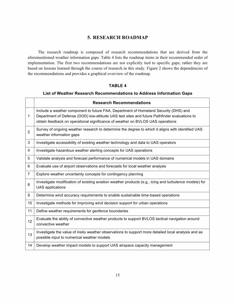
5. RESEARCH ROADMAP
The research roadmap is composed of research recommendations that are derived from the aforementioned weather information gaps. Table 4 lists the roadmap items in their recommended order of implementation. The first two recommendations are not explicitly tied to specific gaps; rather they are based on lessons learned through the course of research in this study. Figure 2 shows the dependencies of the recommendations and provides a graphical overview of the roadmap.
TABLE 4
List of Weather Research Recommendations to Address Information Gaps
Research Recommendations
1 Include a weather component to future FAA, Department of Homeland Security (DHS) and Department of Defense (DOD) low-altitude UAS test sites and future Pathfinder evaluations to obtain feedback on operational significance of weather on BVLOS UAS operations
2 Survey of ongoing weather research to determine the degree to which it aligns with identified UAS weather information gaps
3 Investigate accessibility of existing weather technology and data to UAS operators
4 Investigate hazardous weather alerting concepts for UAS operations
5 Validate analysis and forecast performance of numerical models in UAS domains
6 Evaluate use of airport observations and forecasts for local weather analysis
7 Explore weather uncertainty concepts for contingency planning
8 Investigate modification of existing aviation weather products (e.g., icing and turbulence models) for UAS applications
9 Determine wind accuracy requirements to enable sustainable time-based operations
10 Investigate methods for improving wind decision support for urban operations
11 Define weather requirements for geofence boundaries
12 Evaluate the ability of convective weather products to support BVLOS tactical navigation around convective weather
13 Investigate the value of insitu weather observations to support more detailed local analysis and as possible input to numerical weather models
14 Develop weather impact models to support UAS airspace capacity management
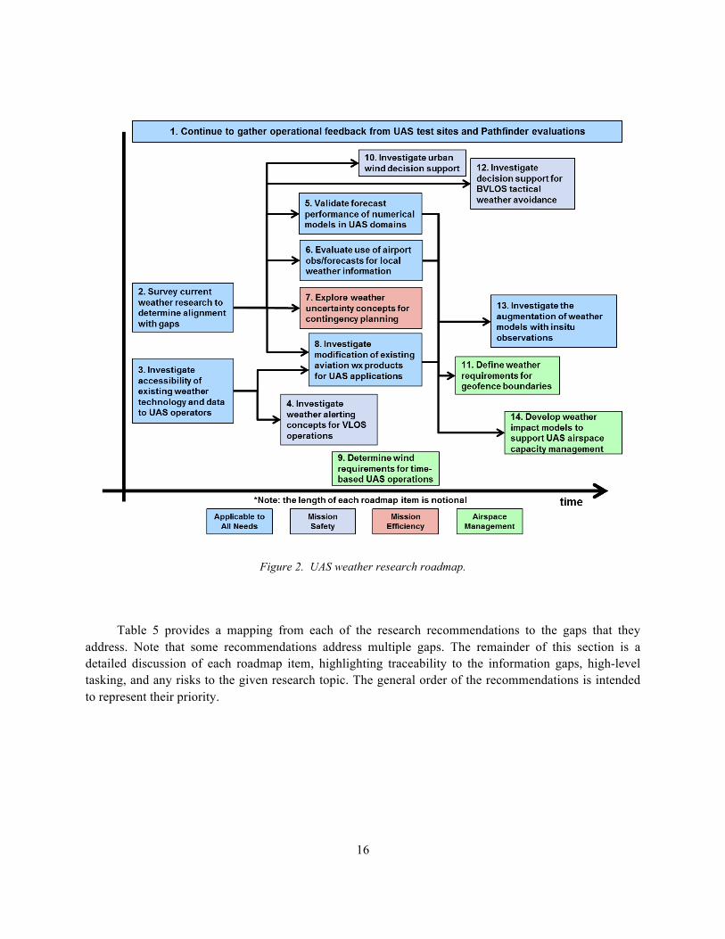
16
Figure 2. UAS weather research roadmap.
Table 5 provides a mapping from each of the research recommendations to the gaps that they address. Note that some recommendations address multiple gaps. The remainder of this section is a detailed discussion of each roadmap item, highlighting traceability to the information gaps, high-level tasking, and any risks to the given research topic. The general order of the recommendations is intended to represent their priority.
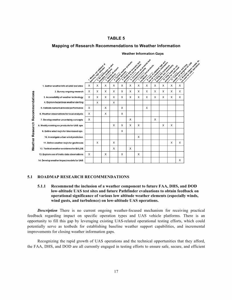
17
TABLE 5
Mapping of Research Recommendations to Weather Information
gaps
5.1 ROADMAP RESEARCH RECOMMENDATIONS
5.1.1 Recommend the inclusion of a weather component to future FAA, DHS, and DOD low-altitude UAS test sites and future Pathfinder evaluations to obtain feedback on operational significance of various low altitude weather elements (especially winds, wind gusts, and turbulence) on low-altitude UAS operations.
Description There is no current ongoing weather-focused mechanism for receiving practical feedback regarding impact on specific operation types and UAS vehicle platforms. There is an opportunity to fill this gap by leveraging existing UAS-related operational testing efforts, which could potentially serve as testbeds for establishing baseline weather support capabilities, and incremental improvements for closing weather information gaps.
Recognizing the rapid growth of UAS operations and the technical opportunities that they afford, the FAA, DHS, and DOD are all currently engaged in testing efforts to ensure safe, secure, and efficient

18
operation of UAS, including integration with manned aircraft within the NAS. Examples are the designation of six FAA UAS test sites to conduct research and validate concepts, DHS alliance with the university research community for testing UAS-related security issues, DOD testing of UAS to support military operations, and the Pathfinder mission within the FAA Integration office to allow UAS operational research collaboration with private industry. Although weather is an important consideration for conducting test operations, most of these efforts do not include collecting and archiving UAS-relevant weather data and documenting when adverse weather unexpectedly impacted UAS operations as a primary research component. In general, conduct of operational testing requires substantial logistical coordination, technical resources, and financial resources. These existing efforts provide an opportunity for the FAA to leverage ongoing UAS projects to identify and quantify existing weather information gaps, to resolve questions of the practical significance of some weather phenomena for UAS operations, and allow a baseline for measurement of future improvements.
As an example of the importance of understanding practical significance of weather issues, we note the MIT Lincoln Laboratory experiments at cell phone detection as a means of locating victims of building collapse (e.g., due to earthquakes or terrorist incidents). The operational concept was to use a low-altitude UAS that flies very close to the collapsed buildings as described in appendix C of [1] and shown in a video [2]. One might imagine that low-altitude turbulence and urban wind effects could be a significant hindrance to such UAS usage. However, the experience at the test site showed that once a wire cage had been put around the quadcopter blades to protect them from structure impacts, the UAS was very successful at flying very-low-altitude missions. Hence, in that case, there’s little need to get into a potentially expensive wind/turbulence modeling study to see if such an UAS application was feasible.
The FAA UAS Center of Excellence might serve as a resource for initiating collaboration and perhaps facilitate the acquisition and archiving of test site weather data and incidents where adverse weather unexpectedly impacted UAS operations.
Outcomes The primary outcome of this recommendation is operational feedback and/or weather data to help define the impact of weather on future operational concepts such as BVLOS or urban operations.
Traceability to weather information gaps report This topic is applicable to all identified weather information gaps.
Outline of tasking
1. Identify and characterize existing UAS-related efforts within the FAA, DHS, and DOD thatinvolve operational testing that could help resolve questions on the operational significance ofvarious weather phenomena to important UAS applications.
2. Establish mapping between weather information gaps, existing/required weather informationresearch, and appropriate UAS testing programs.
19
3. Compile a concept document describing generalized requirements, expectations, andconsiderations for collaboration. This would include recommendations for collecting andarchiving UAS-relevant weather data, and documenting when adverse weather unexpectedlyimpacted UAS operations.
4. Establish contact with appropriate organizational management; distribute collaboration conceptdocument.
4. Based on communication with organizations, compile a collaboration prioritization list basedon project synergy to support the weather research component, and ability/willingness oforganizational management to cooperate in collaboration.
5. Compile project proposal and collaboration agreement for top-priority collaborativeopportunities.
Uncertainties and risks to research
1. There may be resistance from some organizations to participating in inter-agency efforts.
2. Inter-agency collaboration requires clear establishment of authority, roles, and tasking in orderto avoid conflicts.
5.1.2 Recommend a survey of ongoing weather research to determine the degree to which it aligns with identified UAS weather information gaps.
Description Many of the identified information gaps cite a skill or precision deficiency in existing forecast capabilities, or mechanism for translating existing current capabilities for UAS-specific requirements. The scientific community continues to advance weather and forecasting technology for conventional aircraft via research programs, primarily administered and executed by government agencies (including the military), federally funded research organizations, and universities that receive government research grants. This recommendation intends to: 1) identify existing research that is already progressing toward filling identified gaps, 2) align or extend existing research to help address key UAS weather information needs when possible, 3) identify gaps for which new research needs to be initiated.
Outcomes This recommendation has the potential to decrease UAS weather research costs by leveraging current ongoing work. The deliverable would be a directory of ongoing research that can be leveraged for UAS operations.
Traceability to weather information gaps report This topic is applicable to all identified weather information gaps.
20
Outline of tasking
1. Identify major organizations with ties to meteorological research, both in the public and private sectors. This includes federal agencies, military, and universities. Within these organizations, identify and characterize ongoing research that may potentially map to the identified UAS weather information gaps. Assess the degree to which efforts performed within existing research plans will address specific gaps, or whether current research objectives and plans could be readily modified or expanded to address these gaps.
2. For existing research that would require modification to address UAS weather information gaps, assess the level of modification required and propose a modified research plan. Assess additional level of effort required to execute modified plan.
3. Prioritize modified research plans, favoring those that would provide the most leverage in addressing UAS weather information gaps.
4. Identify UAS weather information gaps that do not currently map to any existing ongoing research, and may require establishment of new research initiatives.
Uncertainties and risks to research
1. The breadth of ongoing researching makes this a difficult challenge; it will be important to focus on larger organizations and universities.
2. Many research programs are contractually structured such that they are difficult to modify in the short term.
5.1.3 Investigate accessibility of existing weather technology and data to UAS operators
Description There are a number of weather technologies that may have benefit to UAS operations but limited access to UAS operators. Examples are wind shear detection products associated with the Terminal Doppler Weather Radar (TDWR) and Low Level Wind Shear Alert System (LLWAS) systems, precipitation and wind products associated with the ITWS and CIWS programs, output in text format from numerical models such as the High Resolution Rapid Refresh (HRRR), or specialized products such as the Helicopter Emergency Medical Services (HEMS) tool developed by the National Weather Service. Many of these information sources and products would be of value to support unmanned operations and traffic management, but their availability is somewhat restricted. They are largely available internally at FAA facilities (towers, Terminal Radar Approach Controls [TRACONs], en route centers, command and control center, etc.), research websites, or aviation weather portals.
Future availability of data and products will be broadened via the information distribution mechanisms that are part of the FAA NextGen architecture—e.g., the Common Support Services for Weather (CSS-Wx). This recommendation is to investigate mechanisms to distribute limited-access
21
weather products to the general UAS operational community, and to determine how the use of such products by the general UAS operational community might be facilitated.
Outcomes Existing weather technology and products may be able to address weather gaps by increasing accessibility to UAS operators. This would have the benefit of reducing future UAS weather research expenses. The deliverable would be service/cost analysis of increasing the accessibility of limited-access weather technology to UAS operators.
Traceability to weather information gaps report This topic is applicable to all identified weather information gaps.
Outline of tasking
1. Identify candidate weather technology that has limited access to the UAS community.
2. Evaluate the sufficiency of planned NextGen distribution mechanisms for distributingweather information and products that may have limited or restricted access.
3. Evaluate methods to make non-FAA weather data or technology (e.g., HRRR, HEMS tool)more available to the general UAS community.
4. Determine risk/cost of expanding/facilitating accessibility to private industry or generalpublic. Some discussions with industry are already underway (e.g., PASSUR Aerospace,The Weather Company, etc.)
Uncertainties and risks to research None expected.
5.1.4 Investigate Weather Alerting Concepts for Visual Line of Sight (VLOS) Operations
Description Abrupt changes in weather can present a hazard to Visual Line of Sight (VLOS) operations, which are largely conducted by operators at the mission site who can physically see and feel the weather. In this case, the operator typically judges weather safety in a real-time fashion with the assumption that the UAS can be recovered quickly if any weather hazards are observed. However, a significant safety threat exists if the weather hazards are either invisible to the operator or they change rapidly enough to preclude safe recovery. Convective weather, and the associated wind changes, is an example of a dynamic weather hazard that can be unnoticed by a VLOS UAS operator. The outflow from convective weather is largely invisible and can result in gust fronts with speeds that easily overcome the performance limitations of a small UAS. Moreover, isolated and growing convective cells can go undetected if they are out of the field of view of the operator. The associated precipitation and high winds can result in loss of control, leading to collision with people/property in the ground and/or encroachment into busy airspace for manned traffic.
22
One mechanism to raise awareness of changing weather conditions is to alert UAS operators to any nearby weather hazards. Much like weather alerting systems in manned aviation, the objective of a weather alert is to warn the UAS operator of impending hazards so that they can recover their UAS prior to the weather event. However, there are a number of key research questions that need to be addressed to determine the feasibility of a weather alerting system for UAS operations. This proposed work is similar to studies conducted by the FAA’s Weather Technology in the Cockpit (WTIC) program for conventional aviation.
Outcomes Weather alerting will increase safety for VLOS operations by providing operators a warning of otherwise invisible weather conditions. The deliverable would be a validated candidate weather alerting system for VLOS UAS operators.
Traceability to weather information gaps report
Gap #2: No mechanism to alert operators to rapid changes in surface winds (e.g., due to microburst outflows, gust fronts and sharp synoptic fronts).
Gap #4: Tactical convective weather products readily available to UAS operators often lack short-term storm forecasts and are susceptible to latencies.
Outline of tasking
1. Identify use cases in which weather alerting is necessary to maintain safety. Examplesmissions include VLOS operations over populated areas such as construction mapping andinspection, first responders, and media.
2. Identify weather sources necessary to generate alerts. Potential weather sources shouldinclude publically available weather data, such as Next Generation Weather Radar(NEXRAD), in addition to FAA conventional aircraft weather decision support systems(such as ASR-9 WSP, ITWS, CIWS [3] and NWP/CSS-Wx).
3. Explore data transfer mechanisms to enable weather alerting in the identified use cases. Thetradeoffs between data transfer bandwidth, technology availability, and cost need to beinvestigated in order to understand the feasibility of weather alerting for VLOS operations.
4. Perform alert processing studies. This task explores the performance levels (probability ofdetection vs. false alarm rate) of different alerting concepts in predicting weather impact.The effect of look-ahead time on alert performance should also be characterized.
5. Explore the effect of different alerting modalities on UAS operator decision making. Themodalities should include the type of device that presents the alert to the operator as well asthe type of alert (visual, aural, etc.). This investigation is most likely accomplished with ahuman-in-the-loop evaluation.
23
6. Determine the cost/benefit relationship for different alerting mechanisms and modalities.
Uncertainties and risks to research
1. Some rural locations may lack the necessary radar coverage to determine gust front/microburst locations. In these areas, additional research is required to assess the feasibility of gust front detection and outflow forecasting.
2. Some rural locations may be outside of the current data transfer (e.g., cellular) coverage area.
5.1.5 Validate effectiveness and applicability of numerical weather models in supporting UAS missions
Description The most significant weather information gap identified by this study is the lack of weather observations and uncertainty of forecasts in off-airport areas, especially where there is a large variation in terrain, or significant weather influence by localized effects (e.g., land-water interface, heavy forestation/vegetation, etc.) This represents a significant gap for all types of UAS operations, but especially those that operate in the low-altitude domain.
By their very nature, numerical weather models are best suited to provide a generalized solution for filling the off-airport information gaps, as they provide the necessary spatial/geographic coverage, and are structured to capture the physical forcing mechanisms associated with terrain variation and localized forcing mechanisms. Indeed, there have been great advancements in these models over recent decades in their improved spatial resolution (including terrain), direct physical modeling, and indirect physical parameterizations. Model outputs have also expanded to include critical elements related to aviation, such as cloud characterization (areal coverage, ceiling height, layers, etc.), horizontal visibility estimates, and physical characteristics associated with icing. However, metrics for validating model performance and assessing improvement have not typically focused on these key aviation-related elements, particularly in terms of localized performance. In order to serve UAS operations, this type of analysis should be performed to characterize model reliability in addressing the off-airport information gap, and for monitoring progress as these models continue to evolve so that their relevance can be more of a consideration in the development process.
Outcomes Validated off-airport weather models will help define if current models can be used as-is, or if addition development is needed. This deliverable would be an evaluation report for numerical model performance of low-level winds, ceiling, and visibility.
Traceability to weather information gaps report
Gap #1: Numerical weather model performance uncertain in off-airport areas, especially where there is a large variation in terrain.
24
Gap #3: Off-airport weather observations (visibility, ceiling, wind) are sparse.
Gap #5: Current wind aloft forecasts lack precision and winds aloft observations are lacking in the low-altitude and super-high-altitude regions.
Gap #8: Lack of validated stratospheric and low-altitude turbulence information.
Outline of tasking
1. Identify weather models that output winds, ceiling, and visibility in the low-altitudedomain.
2. Investigate sources for truth data. Particular focus should be on acquiring off-airportobservations, such as radar-derived wind observations or observations acquired from non-standard sources (e.g., local mesonets operated by universities, or other sensors operated byprivate industry, etc.; see Roadmap Item #13). As part of this task, consider what additionalsensors deployment may be required to augment existing sensors as part of a data collectioncampaign to support this analysis.
3. Evaluate model analysis field performance in different geographical areas.
4. Evaluate model forecast performance in different geographical areas, particularly for low-level winds and ceiling/visibility.
Uncertainties and risks to research
1. The availability of adequate truth data is uncertain.
2. Difficult to evaluate all geographical dependencies.
5.1.6 Evaluate use of airport observations and forecasts for local weather analysis
Description VLOS operations require accurate estimates of ceiling and visibility to ensure safety and separation from manned traffic. Additionally, strong or gusty surface winds and winds aloft can be hazardous, especially for small UAS. Currently, operators typically estimate local weather conditions by using weather observations and forecasts from nearby airport Meteorological Terminal Aviation Routine Weather Report (METAR) and Terminal Area Forecast (TAF) as a surrogate for local conditions, or by making ad hoc adjustments for geographical differences. Additionally, low-altitude operators at off-airport locations try to assess winds aloft based on surface observations and higher conditions/forecasts for nearby airports. The reliability of these adjustments is unclear, and almost certainly varies by location. Furthermore, reliability also is likely to be highly dependent on the meteorological knowledge and skill of the operator trying to make the adjustments.
25
This recommendation is to evaluate the effectiveness of using nearby airport weather observations and forecasts as a surrogate for estimating local conditions, or for making adjustments using the airport information as a baseline. One goal would be to determine the sensitivity in accuracy of these adjustments to the distance, time, and geographic location of the observation. The analysis should consider seasonal effect to the sensitivity.
Outcomes The reliability of estimating local conditions and short term forecasts based on weather information from one or more nearby airports will help determine the need for a higher resolution weather observation network for UAS operations. It can also be used for comparison with the NWP accuracy analysis associated with Recommendation #5. The deliverable would be a report on the sensitivity in accuracy of local weather to the distance, time, and geographic location of airport-based weather observations.
Traceability to gaps report
Gap #1: Numerical weather model performance uncertain in off-airport areas, especially where there is a large variation in terrain.
Gap #3: Off-airport weather observations (visibility, ceiling, wind) are sparse.
Gap #5: Current wind aloft forecasts lack precision and winds aloft observations are lacking in the low-altitude and super-high-altitude regions.
Outline of tasking
1. Identify candidate geographic areas for study. There should be sufficient diversity in the areas.
2. Investigate sources for truth data. Particular focus should be on acquiring off-airport observations, such as radar-derived wind observations or observations acquired from non-standard sources (e.g., local mesonets operated by universities, or other sensors operated by private industry, etc.; see Roadmap Item #13). A field study that includes deployment of temporary sensors to provide quantified validation of local conditions may be warranted.
3. Evaluate reliability of using nearby airport weather information as raw surrogate for local weather information, or as a baseline for an adjusted local estimate of current and forecast conditions.
4. Evaluate the sensitivity in accuracy of these approaches to the distance, time, and geographic location of airport-based weather observations (e.g., ceiling, visibility, and wind).
Uncertainties and risks to research
26
1. The availability of adequate truth data is uncertain.
2. Difficult to evaluate all geographical dependencies, or to develop generalized solutions.
5.1.7 Explore weather uncertainty concepts for contingency planning
Description A primary concern of UAS operators conducting BVLOS missions is lost-link contingency planning. The current operational philosophy is to be very conservative in go/no-go decision making even if there is a small chance of weather impact (e.g., convective weather, turbulence, or icing) on either the flight plan or contingency routing. This results in a relatively high cancellation rate compared to conventional aviation, and significantly decreases the efficiency and potential benefit of BVLOS operations.
This recommendation is to explore concepts to provide UAS operators with weather impact uncertainty information to aid in contingency planning. The intent of this recommendation is to decrease mission cancellation rate by increasing user confidence in forecasts of route-based weather impacts. The research can be divided into two thrusts. One research thrust is to develop route or flow-based weather impact uncertainty algorithms that translate multiple weather forecasts into a single measure of route availability uncertainty. This is very similar to recent work conducted by MIT Lincoln Laboratory on the Traffic Flow Impact (TFI) capability for conventional air traffic management [4]. The other research thrust should investigate methods to display weather impact uncertainty information to UAS operators such that it increases trust and improves contingency planning. This will be accomplished through rigorous human factors evaluation of candidate uncertainty display methods. Note there is significant overlap in this area with ongoing research and development in conventional air traffic management.
A key issue in contingency planning is the degree of tactical decision support available. If there is effective tactical capability for rerouting, then the level of certainty that no hazardous weather conditions (e.g., convective weather penetration) will be encountered in a planned flight can be relaxed. When the initial user needs survey was carried out in 2016 [1], there was little or no tactical convective weather decision support available outside the lower 48 states in the U.S. However, the possibility of providing effective tactical decision support for routing around scattered convective storms has changed significantly as a consequence of the FAA AWRP development of the Offshore Precipitation Capability (OPC) [5]. The 2016 OPC demonstration at the Miami Air Route Traffic Control Center (ARTCC) demonstrated operationally effective current depictions of areas of significant convection as well as 0–2 hour forecasts.
Outcomes A better understanding of weather impact uncertainty will improve the efficiency of BVLOS missions. The deliverable would be completed in two parts: 1) it would be an algorithm to estimate UAS weather uncertainty, and 2) it would be a human in the loop (HITL) evaluation of the effectiveness of different uncertainty display concepts.
Traceability to weather information gaps report
27
Gap #1: Numerical weather model performance uncertain in off-airport areas, especially where there is a large variation in terrain.
Gap #6: Strategic convective weather products lack precision at long forecast horizons and need better uncertainty information to support decision making.
Gap #9: Icing and turbulence forecasts lack an uncertainty element to support contingency planning.
Outline of tasking
1. Coordinate with stakeholders to establish use cases that highlight operations where a lackof weather uncertainty information impacts efficiency.
2. For the identified use cases, build an archive of historical weather information (convection,turbulence, and icing) that can be used to train and test machine learning models.
3. Develop a machine learning framework to generate route-based weather uncertaintyestimates. Leverage existing work on incorporating weather impact uncertainty, where anexample is the TFI program [4].
4. Create candidate representations of route-based uncertainty for evaluation.
5. Investigate the effectiveness of different uncertainty representations in decreasing BVLOSmission cancellation rate.
Uncertainties and risks to research
1. The inherent uncertainty in long-range weather forecasts may be too large to realize abenefit. In other words, if there is always significant uncertainty in the weather impact, itwill be difficult to lessen the current conservative operational mentality unless there isadditionally a robust tactical decision support capability.
5.1.8 Investigate modification of existing products to better address specific UAS operator concerns
Description Existing weather information and forecasts designed for conventional aviation safety and efficiency may require modification to achieve effectiveness for UAS operations. Products such as the Graphical Turbulence Guidance (GTG) model and the Current Icing Product (CIP) are tuned to represent turbulence and icing levels for larger aircraft operating at traditional altitudes for manned air traffic. The models may not be representative of small UAS turbulence and icing, and the model performance in low-altitude (below 1000 ft) and very high-altitude (above FL450) requires evaluation. Moreover, the icing models do not account for the “cold-soak” effect, which is common among UAS
28
descending from very high altitudes. Lastly, existing microburst and gust front products should be broadened to include all wind shift boundaries, not just the cores.
This roadmap item recommends identification of relevant products, and investigating potential modifications to that address some of the aforementioned gaps. The result of this recommendation is a prioritized outline of modifications to current weather products to better serve UAS operators.
Outcomes The modification of existing weather products is a potentially low-cost solution to address weather info gaps. This deliverable would be a prioritized list of modifications to existing weather technology, including includes estimates of required effort and potential benefit.
Traceability to weather information gaps report
Gap #4: Tactical convective weather products lack short-term forecasts and are susceptible to latencies. Examples: Broaden microburst gust front detection to include wind shift boundaries not associated with thin line reflectivity and assess how the microburst detection product could be used to detect strong storm outflows that are too small in spatial extent to be detected by the gust front algorithm in ITWS and NWP. NWP short-term convection forecasts should, in most cases, meet the UAS needs for short-term convective forecasts. Expand convective weather products to support see-and-avoid capability.
Gap #5: Current wind aloft forecasts lack precision and winds aloft observations are lacking in the low-altitude and super-high-altitude regions. Examples: Infuse additional sensor data to improve Terminal Winds Product, particularly at low levels (under 1000 feet). Extend Terminal Winds product to provide forecast capability.
Gap #6: Strategic convective weather products lack precision at long forecast horizons and need better uncertainty information to support decision making.
Gap #7: Urban wind products are not sufficient and are not available to the public.
Gap #10: Icing models do not account for effect “cold soak” effect.
Gap #11: Turbulence and icing models not designed for small UAS.
Outline of tasking
1. Identify relevant existing products.
2. Identify product deficiency in meeting UAS-specific need, and propose technical changes toachieve better alignment.
3. Assess level of effort and technical risks/challenges associated with modification.
4. Prioritize modifications based on required effort and expected benefit.
29
Uncertainties and risks to research
(U) Some existing products may depend on legacy technology that is not readily adaptable for modification.
5.1.9 Determine wind accuracy requirements to enable sustainable UAS time-based operations.
Description A cornerstone to UAS integration is the concept of time-based operations. As the number of UAS operations in the airspace increase, it will be increasingly important to plan four-dimensional trajectories to efficiently allocate airspace to both UAS and manned aircraft. Much like the current air traffic management system, future UAS traffic management systems will be sensitive to cascading delays and inefficiencies caused by flights unable to conform to their planned routes and arrival times. A significant barrier to sustainable time-based operations is inaccurate wind forecasts, which can cause unplanned changes in groundspeed that either result in an early or late arrival time to a waypoint. Small UAS are especially sensitive to wind errors due to their relatively slow cruise speeds, which in certain cases are no more than 30 knots. In this example, a 15-knot change in winds aloft will result in a 50% change in uncompensated flight time to a waypoint. Most UAS are equipped with autopilots that can compensate for some wind error; however it is unclear how accurate wind forecasts need to be to ensure time-based operations are feasible for small UAS operations.
Outcomes It is critical to understand wind accuracy requirements for UAS time-based operations in order to know how much wind forecasts need to improve, if at all. This deliverable would be a set of wind accuracy thresholds for different UAS platforms and flight control technologies.
Traceability to weather information gaps report
Gap #5: Current wind aloft forecasts lack precision and winds aloft observations are lacking in the low-altitude and super-high-altitude regions.
Outline of tasking
1. Identify candidate flight control systems/autopilots for a variety of representative UAS.
2. Determine the feasibility of time-based operations for different flight control platforms under different levels of wind uncertainty. This would be accomplished through modeling and simulation.
3. Set thresholds for required wind accuracy based on UAS platform or category.
Uncertainties and risks to research
30
1. Thresholds will change as new technology is introduced
5.1.10 Investigate methods for improving wind decision support for urban operations.
Description Winds in an urban environment are highly affected by the structure of the surrounding buildings and terrain. Buildings act to break up a smooth air and form turbulent eddies that propagate well downstream of the urban area. Groups of buildings can form “urban canyons” that significantly change the speed and direction of the wind.
The controllability of small UAS is very sensitive to wind, and any unexpected change in wind can result in a very hazardous situation. Loss of control of a UAS in an urban environment can easily end in a collision with either property or people on the ground. It is critical to better understand urban wind effects to enable UAS operations in cities (first responder missions, etc.). This research recommendation should leverage existing weather research and operational testing by the Army and the Department of Homeland Security.
Outcomes Empirical investigation of urban wind model performance and operational usability will determine the feasibility of current models for UAS operations and highlight areas for improvement. This deliverable would be an operational evaluation of current urban wind models.
Traceability to weather information gaps report
Gap #7: Urban wind products are not sufficient and are not available to the public.
Outline of tasking
1. Coordinate research with ongoing work being conducted by the Army and the Departmentof Homeland Security.
2. Identify testbeds for urban operations capable of wind data collection and flight testing.
3. Explore tradeoffs between model fidelity/observation network resolution and operationalusability.
Uncertainties and risks to research
1. Urban wind fields are highly nonlinear and inherently difficult to model.
2. UAS control systems and concepts of operation may reduce the impact of some urban windphenomena.
3. Need cooperation from Army and DHS researchers as well as first responders (e.g., firedepartments) that are researching the use of low altitude UAS for time/safety criticalapplications.
31
5.1.11 Define weather requirements for geofence boundaries.
Description The most mature form of airspace management for current UAS operations is geofencing. A geofence is essentially an invisible boundary that separates UAS operations from airspace where UAS flight is restricted. Geofences are enforced by providing UAS a boundary defined by points of latitude and longitude that are input to the UAS navigation software as a “no-fly” zone. Currently, geofences are put in place to restrict UAS flights over safety critical areas such as airports, stadiums, and other high-profile outdoor gatherings.
However, it is expected that geofences will become an initial means to prevent UAS from flying in hazardous weather. In order to realize this vision, research needs to be done to define the tolerance of different UAS platforms to weather such that geofence boundaries do not over or under restrict airspace. This recommendation is to define requirements for geofence boundaries.
Outcomes Geofences are the most mature form of airspace management, but it is unclear how effective they are for weather avoidance. This research would validate the use of geofences for certain weather conditions, or recommend any necessary improvements.
Traceability to weather information gaps report
Gap #2: No mechanism to alert operators to rapid changes in surface winds (e.g., due to microburst outflows, gust fronts and sharp synoptic fronts).
Gap #4: Tactical convective weather products lack short-term storm forecasts and are susceptible to latencies.
Gap #11: Turbulence and icing models not calibrated for small UAS.
Gap #12: Weather impact models not calibrated for UAS.
Outline of tasking
1. Identify best data sources (models, observations, etc.).
2. Develop weather impact translation models for different types of UAS.
3. Investigate the tradeoff between uncertainty and forecast horizon.
4. Determine performance levels of geofence airspace management for different weather conditions.
Uncertainties and risks to research
1. Difficult to classify weather tolerance by UAS platform characteristics
32
5.1.12 Evaluate ability of convective weather products to support tactical decision making.
Description Convective weather avoidance is critical in all aspects of aviation. Manned aviation relies on a combination of visual recognition and onboard weather radar to navigate around convective weather. UAS that are operated VLOS can practice visual avoidance in the same fashion although the ability to determine when strong low altitude wind gusts associated with convective storm outflows is poor.
BVLOS operations are different – most platforms are not equipped with airborne weather radar and there is no onboard pilot to visually recognize thunderstorms. One possible solution is to use onboard cameras for cloud recognition; however, the technology needs extensive validation. Ground-based weather sources such as NEXRAD depict convective weather, but there are latencies in processing and transferring the data to an operator with contemporary commercial vendors (e.g., Foreflight) that may invalidate its use for tactical weather avoidance3. The FAA’s NextGen Weather Processor (NWP) makes extensive use of NEXRAD and TDWR radar data and provides that data along with high-quality short-term forecasts to Air Traffic Control (ATC) facilities and airlines over high bandwidth communication channels. The effective latency of NWP products is lower than that of contemporary commercial vendor NEXRAD depictions, and some of the technology within the NWP could be used to reduce the impact of latency in data transfer from the NWP to the UAS operator (see Appendix B).
This recommendation is to investigate methods for tactical convective weather avoidance for BVLOS operations including those that capitalize on the FAA products that are available with NWP together with the CSS-Wx product distribution capability. The research should consider the tradeoffs between onboard video recognition, fast update rate ground-based products, and short range convective weather forecasts together with user display (e.g., app) processing to reduce the operational impact of communications latency. A key difference between this topic and Recommendation #4 is that this recommendation is considering the complete navigation around convective weather, whereas #4 is solely focused on alerting the operator to the presence of hazardous weather.
3 The FAA has not determined what convective weather data is suitable for low altitude VLOS. For conventional manned aircraft, Advisory Circular 06-23 A has the following regarding Product Latency: Be aware of the product time or “valid until” time on the particular data link information displayed in the flight deck. (For example, since initial processing and transmission of next generation weather radar (NEXRAD) data can take several minutes, pilots must assume that data link weather information will always be a minimum of 7 to 8 minutes older than shown on the time stamp. Thus, pilots must only use data link weather radar images for broad strategic avoidance of adverse weather.) Pilots operating part 121 domestic or flag flights should contact their dispatcher for verification of adverse non-forecast weather information. This is particularly important when adverse weather phenomena are encountered and a change to the route or alternate may be required.
33
Outcomes UAS operators conducting BVLOS missions need an alternative weather source for tactical weather avoidance. This deliverable would be an assessment of different types of tactical information for weather avoidance and navigation during convective weather events.
Traceability to weather information gaps report
Gap #4: Tactical convective weather products lack short-term forecasts and are susceptible to latencies.
Gap #6: Strategic convective weather products lack precision at long forecast horizons and need better uncertainty information to support decision making.
Outline of tasking
1. Investigate data and tactical convective weather product sources (e.g., NEXRAD, NextGenWeather Processor [NWP]).
2. Quantify risk due to latency arising from radar scanning, mosaicking, and data transfer ratelimitations.
3. Assess the utility of short-term forecast/extrapolation techniques planned for NWP tomitigate latency errors from processing and/or low communication rates (e.g., cell phone)from the product provider to the product user). Assess other techniques for reducing theimpact of latency arising from low communication rates (e.g., cell phone) from the productprovider to the product user.
4. Evaluate the ability of different types of convective weather identification (e.g., NWP,NEXRAD, onboard camera) to support tactical decision making through human-in-the-looptesting.
Uncertainties and risks to research
1. There is uncertainty in the concept of operations for BVLOS navigation around weather.
5.1.13 Investigate the augmentation and distribution of existing weather observations to support more detailed local analysis possible input to Numerical Weather Prediction models
Description There is a significant gap in the understanding of low-altitude off-airport weather conditions, in part caused by a sparse network of airport-based weather observation stations. In some cases, off-airport weather information can be provided by numerical weather model data; however, the accuracy of the model data in the low-altitude domain is an open research question, especially in areas where there are large terrain variations. This gap is most applicable to small UAS that are more
34
susceptible to wind changes than their larger counterparts, and may have specific VLOS weather requirements.
There are a number of existing sensors deployed for research and industry (Lidars, profilers, surface mesonets, etc.), and private consumption (e.g., Weather Underground local observations) that have the potential to supplement or augment numerical weather model estimates of off-airport weather conditions. Moreover, most UAS have the ability to sense wind direction and speed, which can be shared with other UAS operators or models to improve knowledge of local weather. This recommendation is to investigate the potential to use non-standard weather observations to increase the fidelity of local-area weather predictions.
Outcomes The inclusion of more sensors into the current observation network may greatly improve the understanding of the local microclimate that is of concern to small UAS operators. This deliverable would be a service analysis of using different sensor sources for local weather analysis.
Traceability to weather information gaps report
Gap #1: Numerical Weather Prediction model performance uncertain in off-airport areas, especially where there is a large variation in terrain.
Gap #3: Off-airport weather observations (visibility, ceiling, wind) are sparse.
Gap #5: Current wind aloft forecasts lack precision and winds aloft observations are lacking in the low-altitude and super high-altitude regions.
Gap #7: Urban wind products are not sufficient and are not available to the public.
Outline of tasking
1. Identify existing sensor networks that are not considered official sources of aviation weather (e.g., Weather Underground local observations).
2. Survey research on the use of UAS as weather sensors. Leverage current studies by the University of Oklahoma.
3. Investigate data quality of sensor networks. Benchmark with Automated Surface Observing System (ASOS) where available. Compare to NWP models.
4. Prioritize sensor networks by maturity and potential benefit to UAS operations.
Uncertainties and risks to research
1. It will be difficult to identify a reliable source of truth for some of the sensor networks.
35
2. Data quality of airborne sensors is dependent on UAS platform properties.
5.1.14 Develop weather impact models to support UAS airspace capacity management.
Description As the number of UAS operating in the airspace increases, a UAS traffic management system will be required to allocate airspace to individual UAS in a fair and efficient way. This concept is similar to the vision of the NASA UAS Traffic Management (UTM) program and driven by the same motivations that motivated the development of the current manned aircraft traffic flow management system (TFMS). The central idea is that airspace has limited capacity during certain weather events and traffic demand should be scheduled and routed such that it does not overwhelm constrained resources. In the manned system, strategies such as Airspace Flow Programs, Ground Delay Programs, and Playbook Reroutes are employed to manage demand through capacity constrained airspace. Underlying these strategies is a model, or notion, of the ability of manned aircraft to tolerate flight during specific weather conditions. A straightforward translation of these strategies to UAS operations is not possible due to the wide variety of performance capabilities and weather tolerances of different UAS platforms. Therefore, research is required to determine the ability of different types of UAS to operate in a range of weather conditions, and then to develop models of weather impact such that a system can efficiently allocate weather impacted airspace.
Outcomes Airspace capacity models will enable a higher degree of airspace utilization during weather events, leading to higher efficiency due to intelligent demand planning. This deliverable of this study would be a set of weather impact translation models for different UAS types and weather.
Traceability to weather information gaps report
Gap #12: Weather impact models not calibrated for UAS.
Outline of tasking
1. Work closely with manufacturers to determine weather tolerance for a range of UASplatforms.
2. Classify UAS platforms based on levels of weather tolerance.
3. Work in parallel with NASA UTM and other test beds.
4. Develop algorithms to translate weather into probability of weather impact.
Uncertainties and risks to research
1. Lack of data for UAS operations in weather.
2. Uncertainty in long-term UAS airspace management vision.

This page intentionally left blank.
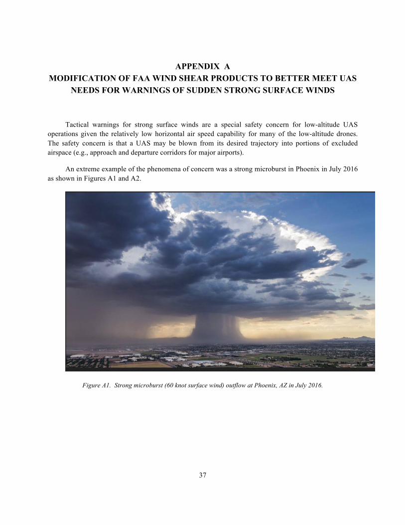
37
APPENDIX A MODIFICATION OF FAA WIND SHEAR PRODUCTS TO BETTER MEET UAS
NEEDS FOR WARNINGS OF SUDDEN STRONG SURFACE WINDS
Tactical warnings for strong surface winds are a special safety concern for low-altitude UAS operations given the relatively low horizontal air speed capability for many of the low-altitude drones. The safety concern is that a UAS may be blown from its desired trajectory into portions of excluded airspace (e.g., approach and departure corridors for major airports).
An extreme example of the phenomena of concern was a strong microburst in Phoenix in July 2016 as shown in Figures A1 and A2.
Figure A1. Strong microburst (60 knot surface wind) outflow at Phoenix, AZ in July 2016.

38
A National Weather System representative for Phoenix claims wind gusts reached 63 mph, meeting the criteria of a severe thunderstorm. Sky Harbor issued a ground stop for all departures at 6:30 p.m. because of strong winds. At 7 p.m., flights resumed.
These strong outflows can occur at locations that do not have a storm overhead as shown in Figure A2. Hence, the existence of such rapidly changing winds (which are not forecast by current numerical weather forecasts models) may not be apparent to an UAS operator on the ground.
Figure A2. Virga descending from a cloud with a ring of dust at the surface generated by the outflow winds of a microburst 27 km east of Stapleton International Airport on 14 July 1982 (lower figure from [6]). The lower figure
was obtained by Prof. T. Fujita [7].
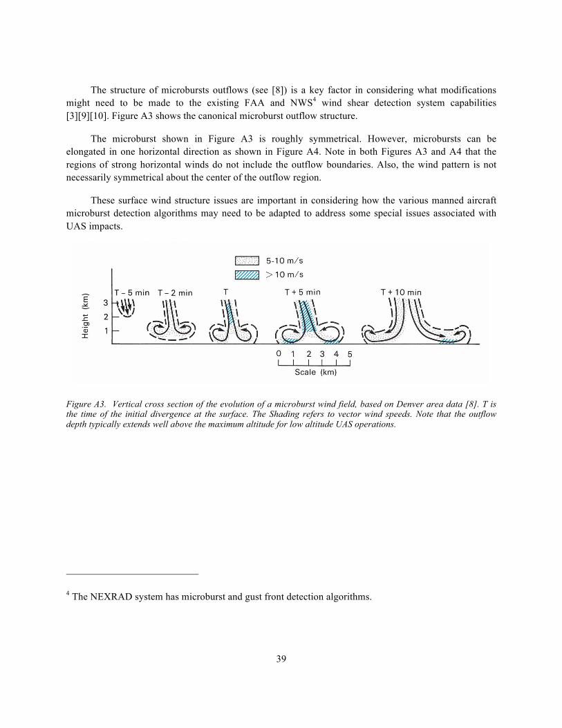
39
The structure of microbursts outflows (see [8]) is a key factor in considering what modifications might need to be made to the existing FAA and NWS4 wind shear detection system capabilities [3][9][10]. Figure A3 shows the canonical microburst outflow structure.
The microburst shown in Figure A3 is roughly symmetrical. However, microbursts can be elongated in one horizontal direction as shown in Figure A4. Note in both Figures A3 and A4 that the regions of strong horizontal winds do not include the outflow boundaries. Also, the wind pattern is not necessarily symmetrical about the center of the outflow region.
These surface wind structure issues are important in considering how the various manned aircraft microburst detection algorithms may need to be adapted to address some special issues associated with UAS impacts.
Figure A3. Vertical cross section of the evolution of a microburst wind field, based on Denver area data [8]. T is the time of the initial divergence at the surface. The Shading refers to vector wind speeds. Note that the outflow depth typically extends well above the maximum altitude for low altitude UAS operations.
4 The NEXRAD system has microburst and gust front detection algorithms.
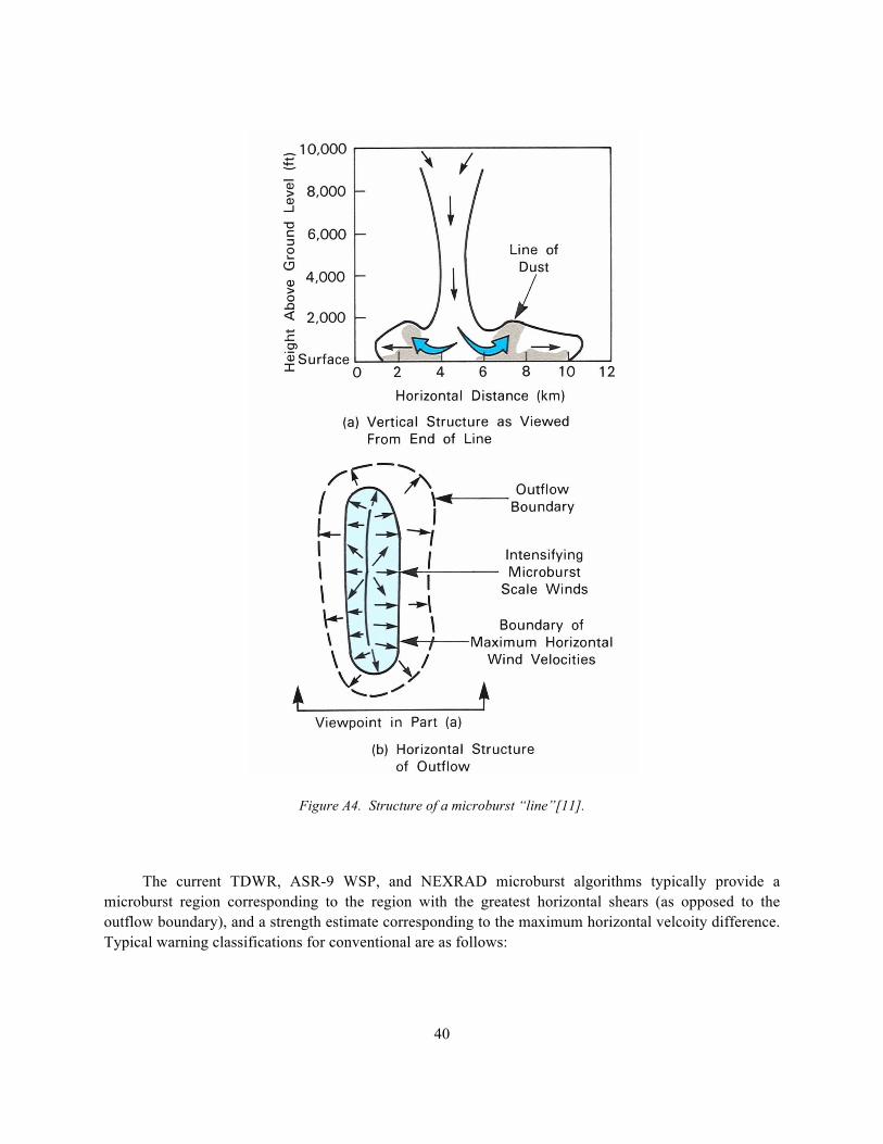
Figure A4. Structure of a microburst “line”[11].
The current TDWR, ASR-9 WSP, and NEXRAD microburst algorithms typically provide a microburst region corresponding to the region with the greatest horizontal shears (as opposed to the outflow boundary), and a strength estimate corresponding to the maximum horizontal velcoity difference. Typical warning classifications for conventional are as follows:
40
41
1. Wind-shear: Regions of divergent shear whose horizontal wind change is less than 15 m/s and diameter is larger than 2 km.
2. Microburst: A region of shear with horizontal wind change greater than 15 m/s and radius less than 2 km.
3. Macroburst: A region of shear with horizontal wind change greater than 15 m/s and radius greater than 2 km.
4. Speed shear (travelling microburst): A microburst or macroburst where the sign of the radial velocity does not change within the cluster.
These warning features were determined based on conventional winged aircraft for which the change in horizontal wind is an indicator of the possible loss in airspeed if a plane were to penetrate the wind shear event.
For low-altitude UAS operational warnings one must first consider the type of low altitude UAS in considering what wind factors are of concern:
a. For conventional winged UAS (e.g., the UAS used by Zipline for Rwanda medical item delivery[12]), the shapes and warning criteria would seem to be similar to those for conventional winged aircraft (albeit the thresholds for warning would need to be adjusted).
b. For quadcopters operating at low altitudes, the lift is generated by the rotor blades rather than by airflow over a lifting service. For such a UAS, one is more concerned about the region of sharp changes in surface and near-surface winds. In this case, one would prefer to have the outflow boundary regions and the maximum horizontal wind velocity associated with the outflow.
There are two ways that the quadcopter decision support needs for leading edge outflow information might be met:
1. When the outflow leading edge extent gets large enough (e.g., horizontal distance on the order of 10 km), the outflow leading edge may be detected as a gust front (thus leading to a circular gust front symbol surrounding a microburst shape). One of the challenges faced by the gust front algorithm detection is that some of the features associated with classical gust fronts from long lasting storm outflows (e.g., convergence in radial velocity and a well defined reflectivity thin line associated with the outflow leading edge) may not be observable over significant portions of the outflow boundary.
2. Existing microburst algorithms could be adjusted to provide a separate UAS shape that corresponds to the outer portion of the storm outflow.

42
These approaches are not exclusive. However, experimental testing with appropriate data sets is clearly needed.
43
APPENDIX B
TECHNIQUES USED TO REDUCE OPERATIONAL IMPACTS OF LATENCY FOR WEATHER RADAR (E.G., NEXRAD) PROCESSING IN THE NEXGEN
WEATHER PROCESSOR
Ideally, weather radar such as NEXRAD could instantaneously measure the environment to detect convective weather and then instantaneously transmit that to the user for display. In practice, the measured data differs from this ideal instantaneous snapshot and transmission due to:
1. The time for the NEXRAD to measure the environment as a function of azimuth at a number of different elevation angles
2. Processing of data from various elevation angles to create gridded volumetric products such as composite reflectivity, vertical integrated liquid (VIL), radar echo tops, etc.
3. Transmission of the volumetric products to a product distribution center (e.g., commercial vendor)
4. Transmission of the user selected products to the user location (e.g., via a cell phone)
Some commercial vendors utilize the volumetric products provided as an output of a NEXRAD from every set of scans over the designated set of elevation angles (i.e., a volume scan). Transmission times from the NEXRADs to the vendor and then to the user is generally greater than 7–8 minutes according to the FAA Advisory Circular 06-23A. Additionally, there is a hidden latency associated with the NEXRAD site providing its volumetric products only at the end of a volume scan, which roughly adds additional latency of about the volume scan time.
There are two major operational impacts of product latency:
1. The storm location portrayed on the user display is in the wrong location (by roughly the storm motion multiplied by latency). For cells moving at 40 knots with 8 minutes latency, this corresponds to 5 NM.
2. The storms may significantly grow or decay over the latency period.
44
The location offset is the major concern that the National Air Traffic Controllers Association (NATCA) controllers have had with the current NEXRAD depictions on their displays5, albeit they would also like to have an indication where the storms are growing or decaying.
The NextGen Weather Processor (NWP) addresses latency by a number of methods taking advantage of short lead time storm tracking and forecasting. The key idea is to advect the measured NEXRAD data6 to an appropriate common time origin in various volumetric analyses and in the product display [13]:
1. Measurements made at the various elevation angles are advected horizontally to provide the best estimate of the storm structure at a common time at which volumetric processing is carried out.
2. The volumetric processing is carried out much more frequently than the volume scan time (e.g., for controller display products, volumetric processing is carried out every 25 seconds).
3. When volumetric results from various NEXRADs (and TDWRs) are combined, the individual radar volumetric processing fields are advected to a common time origin before mosaicking is accomplished.
4. Additionally, the user can choose to see regions where storms are growing or decaying.
The products from NWP are generally sent to FAA user locations over a high-data-rate communications link. Because of the high-data-rate link plus the rapid update rate, it was not deemed necessary to advect the NWP products on the user displays to provide a best estimate of current storm extent.
However, if the NWP products were instead provided to an UAS operator over a low-bandwidth data line (e.g., cell phone), the communication time of the product display could result in an undesirable latency.
5 These issues of NEXRAD product quality have been an issue for some fatal conventional aircraft accidents. For example, the NTSB accident report on the Scott Crossfield accident [14] states that the en route controller’s explanation for not providing information to the pilot regarding severe weather included the following: “…though adverse weather was throughout the area, he did not issue the information to the pilot because he felt that weather conditions displayed on his radarscope were unreliable.”
6 Studies of the accuracy of advected NEXRAD storm locations as an estimate of the current NEXRAD storm location have been carried out since 2003.
45
If one is only interested in a high-quality convective storm location near the operator’s location where the operators’ display system knows both the current time and the time of NWP product generation, there are two options:
1. If the latency (i.e., current time - time of NWP product generation) is less than 15 minutes, then it would be possible to advect the NWP mosaicked volumetric products at the user display by simply providing both the gridded NWP mosaicked volumetric products and an appropriate advection velocity to use in the vicinity of the user’s location. Modern end-user displays (e.g., iPad, iPhone 7) have fairly powerful local processors, so the computation load of translating a gridded display a certain number of pixels N-S and E-W based on the time tag of the product and the display time would seem quite feasible.
2. If the latency were on the order of a short-term forecast time for NWP (e.g., about 15 minutes), then the user should use the NWP forecast corresponding to the current valid time. The communication load associated with forecasts is much less than the communication load associated with a multi-level current weather depiction.

This page intentionally left blank.
47
GLOSSARY
ASOS Automated Surface Observing System ASR-9 Airport Surveillance Radar-9 ATC Air Traffic Control AWC Aviation Weather Center BVLOS Beyond Visual Line of Sight CIP Current Icing Product CIWS Corridor Integrated Weather System CSS-Wx Common Support Services for Weather DHS Department of Homeland Security DOD Department of Defense FAA Federal Aviation Administration GTG Graphical Turbulence Guidance HEMS Helicopter Emergency Medical Services HITL Human in the Loop HRRR High Resolution Rapid Refresh ITWS Integrated Terminal Weather System LLWAS Low Level Wind Shear Alert System METAR Meteorological Terminal Aviation Routine Weather Report NAS National Airspace System NASA National Aeronautics and Space Administration NATCA National Air Traffic Controllers Association NEXRAD Next Generation Weather Radar NWP NextGen Weather Processor SATCOM Satellite Communication TAF Terminal Area Forecast TDWR Terminal Doppler Weather Radar TFI Traffic Flow Impact TFMS Traffic Flow Management System TRACON Terminal Radar Approach Control UAS Unmanned Aircraft System UTM UAS Traffic Management VIL Vertical Integrated Liquid VLOS Visual Line of Sight WSP Weather System Processor WTIC Weather Technology in the Cockpit
49
REFERENCES
1. S. Campbell, D. Clark, and J. Evans, “Weather Information Gaps for UAS Operations,” MIT Lincoln Laboratory, Lexington, MA, ATC Project Report 437, 31 May 2017.
2. “Next Generation First Responder,” MIT Lincoln Laboratory program video, 24 June 2016. https://www.youtube.com/watch?v=PzcMNyGiQ6s&feature=youtu.be
3. Hallowell, R.G., J.Y.N. Cho, S. Huang, M.E. Weber, G. Paull, and T. Murphy, “Wind-shear System Cost Benefit Analysis Update,” Project Report ATC-341, MIT Lincoln Laboratory, Lexington, MA, 2009.
4. Michael P. Matthews, Mark S. Veillette, Joseph C. Venuti, Richard A. DeLaura, and James K. Kuchar, “Heterogeneous Convective Weather Forecast Translation into Airspace Permeability with Prediction Intervals,” Journal of Air Transportation, Vol. 24, No. 2 , pp. 41-54, 2016.
5. Veillette, M., Iskenderian, H., Wolfson, M., Mattioli, C., Hassey, E., Lamey, P., “The Offshore Precipitation Capability,” Project Report ATC-430, MIT Lincoln Laboratory, Lexington, MA, 2016.
6. Wolfson, M.M., “Characteristics of Microbursts in the Continental United States,” MIT Lincoln Laboratory Journal, Volume 1, Number 1, 1988.
7. T. Fujita, The downburst Microburst and Macroburst, Univ. of Chicago Press, 1985.
8. J.W. Wilson, R.D. Roberts, C. Kessinger, and J. McCarthy, “Microburst Wind Structure and Evaluation of Doppler Radar for Airport Wind Shear Detection,” Journal of Climate and Applied Meteorology, Vol. 23, pp. 898-915, 1984.
9. D.J. Smalley, B.J. Bennett, R.S. Frankel, “MIGFA: The Machine Intelligent Gust Front Algorithm for NEXRAD,” 32nd Conference on Radar Meteorology, Albuquerque, NM, Amer. Meteor. Soc., 2005.
10. Mark S. Veillette, B.J. Bennett, M. Pawlak, and R.S. Frankel, “Microburst Detection with NEXRAD AMDA,” MIT Lincoln Laboratory, Lexington, MA, AMS Weather Radar Conference, 2013.
11. L. Stevenson, “The Stapleton Microburst Advisor Service Project - An Operational Viewpoint,” DOTFAA-PM-S5/21, US Dept. of Transportation, Washington, DC, 1985.
50
12. John Markoff, “Drones Marshaled to Drop Lifesaving Supplies Over Rwandan Terrain,” The NewYork Times, 4 April 2016.
13. E.A. Proseus, “Accuracy of Motion-Compensated NEXRAD Precipitation,” MIT LincolnLaboratory, Lexington, MA, ATC Project Report 312, 2003.
14. National Transportation Safety Board, “Aviation Accident Final Report for Accident NumberCHI06MA115,” Ludville, GA, 19 April 2006, Cessna 210A, 2007.

This page intentionally left blank.