Preliminary Study on the Feasibility of a Bicycle-Sharing ...
20
1 Preliminary Study on the Feasibility of a Bicycle-Sharing System at Visayas State University in Baybay City, Leyte Ana Christy ANDRIN a , Jazzy GUTIERREZ b , Butch OCA c , Hanzel MEJIA d a,b,c,d Department of Civil Engineering, Visayas State University, Visca, Baybay City, Leyte, Philippines a E-mail: [email protected] b E-mail: [email protected] c E-mail: [email protected] d E-mail: [email protected] Abstract: This study aims to evaluate whether or not a bicycle-sharing system is feasible at Visayas State University-Main Campus. The feasibility was determined by evaluating the feasibility criteria set which include technical and social aspect. Technical aspects include road safety, accessibility of roads to bicycles, availability of land area for operation, traffic study to analyze the roadway capacity, and proposed stations. The social study includes the determination whether the campus community has sufficient interest in a bicycle-sharing system to pursue such a program. The paper concludes that the bike sharing system proposed is feasible based on the criteria and that further studies regarding the operation and financial viability be explored. Keywords: Bike sharing, Non-motorized transport, Campus transportation, Sustainable transport, Feasibility study 1. INTRODUCTION 1.1 Background For many years now, scientists have been raising concerns about climate change and the potential consequences of the warming of the earth. An excessive amount of carbon in the atmosphere contributes to global warming, with carbon emissions from things such as factories and power plants being a major contributor to increased levels of atmospheric carbon. Automobile emissions are another major source of carbon. They also increase pollution levels, which can lead to all manner of health problems. Carbon Emissions include a number of different chemicals and particulates that are produced when fuel is burned in an engine. Carbon traps heat in the atmosphere, preventing it from escaping from the earth. Consequently, governments around the world have made it a goal to reduce their carbon emissions. Reducing emissions from cars and other vehicles is key to this effort through the promotion of non- motorized transportation. 1.2 Problem Statement The Visayas State University (VSU) is the second largest state university in the Philippines in terms of land area, next to the University of the Philippines Los Baños campus. The five-campus VSU system has eight colleges, three institutes and one school. The school is acknowledged by the Philippine Department of Tourism as a tourist destination because of its diverse flora and fauna bounding the mainland and sea from side to side.
Transcript of Preliminary Study on the Feasibility of a Bicycle-Sharing ...

1
Preliminary Study on the Feasibility of a Bicycle-Sharing System at Visayas
State University in Baybay City, Leyte
Ana Christy ANDRINa, Jazzy GUTIERREZb, Butch OCAc, Hanzel MEJIAd
a,b,c,d Department of Civil Engineering, Visayas State University, Visca, Baybay City, Leyte,
Philippines a E-mail: [email protected] b E-mail: [email protected] c E-mail: [email protected] d E-mail: [email protected]
Abstract: This study aims to evaluate whether or not a bicycle-sharing system is feasible at
Visayas State University-Main Campus. The feasibility was determined by evaluating the
feasibility criteria set which include technical and social aspect. Technical aspects include road
safety, accessibility of roads to bicycles, availability of land area for operation, traffic study to
analyze the roadway capacity, and proposed stations. The social study includes the
determination whether the campus community has sufficient interest in a bicycle-sharing
system to pursue such a program. The paper concludes that the bike sharing system proposed
is feasible based on the criteria and that further studies regarding the operation and financial
viability be explored.
Keywords: Bike sharing, Non-motorized transport, Campus transportation, Sustainable
transport, Feasibility study
1. INTRODUCTION
1.1 Background
For many years now, scientists have been raising concerns about climate change and the
potential consequences of the warming of the earth. An excessive amount of carbon in the
atmosphere contributes to global warming, with carbon emissions from things such as factories
and power plants being a major contributor to increased levels of atmospheric carbon.
Automobile emissions are another major source of carbon. They also increase pollution levels,
which can lead to all manner of health problems. Carbon Emissions include a number of
different chemicals and particulates that are produced when fuel is burned in an engine. Carbon
traps heat in the atmosphere, preventing it from escaping from the earth. Consequently,
governments around the world have made it a goal to reduce their carbon emissions. Reducing
emissions from cars and other vehicles is key to this effort through the promotion of non-
motorized transportation.
1.2 Problem Statement
The Visayas State University (VSU) is the second largest state university in
the Philippines in terms of land area, next to the University of the Philippines Los Baños
campus. The five-campus VSU system has eight colleges, three institutes and one school. The
school is acknowledged by the Philippine Department of Tourism as a tourist destination
because of its diverse flora and fauna bounding the mainland and sea from side to side.
2
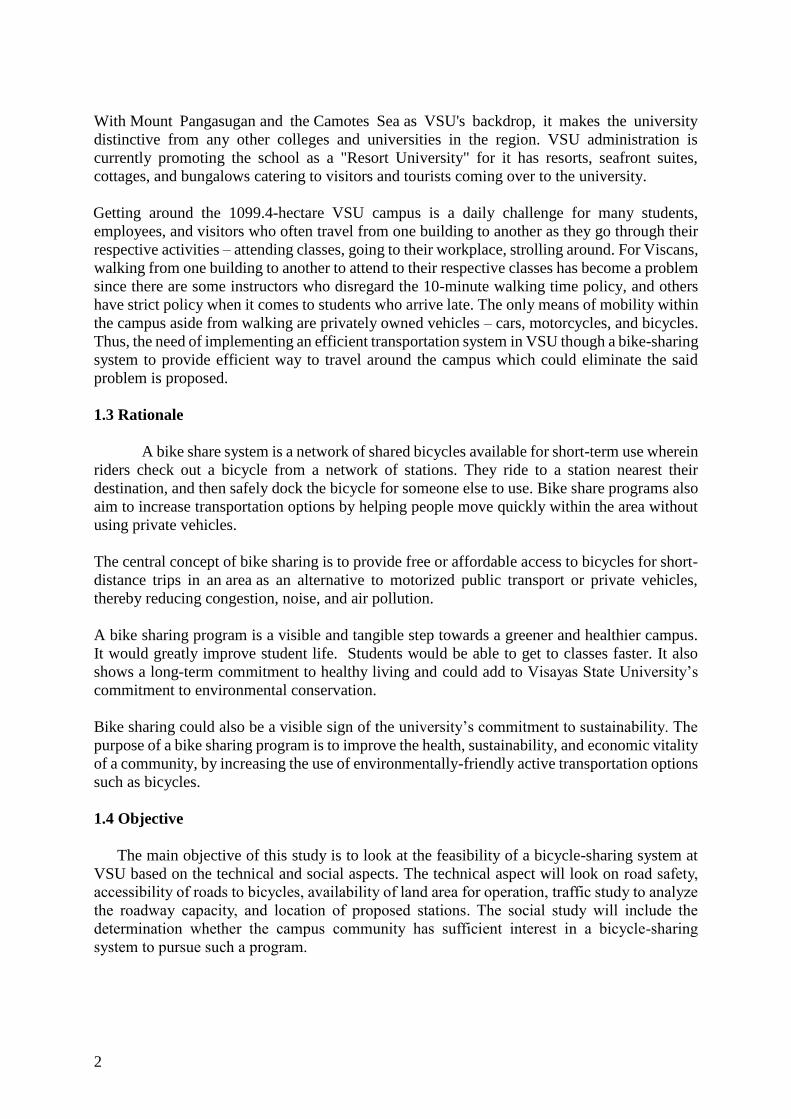
With Mount Pangasugan and the Camotes Sea as VSU's backdrop, it makes the university
distinctive from any other colleges and universities in the region. VSU administration is
currently promoting the school as a "Resort University" for it has resorts, seafront suites,
cottages, and bungalows catering to visitors and tourists coming over to the university.
Getting around the 1099.4-hectare VSU campus is a daily challenge for many students,
employees, and visitors who often travel from one building to another as they go through their
respective activities – attending classes, going to their workplace, strolling around. For Viscans,
walking from one building to another to attend to their respective classes has become a problem
since there are some instructors who disregard the 10-minute walking time policy, and others
have strict policy when it comes to students who arrive late. The only means of mobility within
the campus aside from walking are privately owned vehicles – cars, motorcycles, and bicycles.
Thus, the need of implementing an efficient transportation system in VSU though a bike-sharing
system to provide efficient way to travel around the campus which could eliminate the said
problem is proposed.
1.3 Rationale
A bike share system is a network of shared bicycles available for short-term use wherein
riders check out a bicycle from a network of stations. They ride to a station nearest their
destination, and then safely dock the bicycle for someone else to use. Bike share programs also
aim to increase transportation options by helping people move quickly within the area without
using private vehicles.
The central concept of bike sharing is to provide free or affordable access to bicycles for short-
distance trips in an area as an alternative to motorized public transport or private vehicles,
thereby reducing congestion, noise, and air pollution.
A bike sharing program is a visible and tangible step towards a greener and healthier campus.
It would greatly improve student life. Students would be able to get to classes faster. It also
shows a long-term commitment to healthy living and could add to Visayas State University’s
commitment to environmental conservation.
Bike sharing could also be a visible sign of the university’s commitment to sustainability. The
purpose of a bike sharing program is to improve the health, sustainability, and economic vitality
of a community, by increasing the use of environmentally-friendly active transportation options
such as bicycles.
1.4 Objective
The main objective of this study is to look at the feasibility of a bicycle-sharing system at
VSU based on the technical and social aspects. The technical aspect will look on road safety,
accessibility of roads to bicycles, availability of land area for operation, traffic study to analyze
the roadway capacity, and location of proposed stations. The social study will include the
determination whether the campus community has sufficient interest in a bicycle-sharing
system to pursue such a program.

3
2. LITERATURE REVIEW
2.1 Bike-sharing systems around the world
Bike-sharing is a system involving the self-service rental of bicycles, mostly located in
city centers. The system allows users to rent a bike for a selected period of time (even for a few
minutes) via a mobile application. Its essence is based on the possibilities offered by classic
rental systems without needing to contact an office. Rentals can be made 24 hours a day and
payments are taken from the user’s bank account or credit card. As of December 2016, roughly
1000 cities worldwide have a bike-sharing program.
The beginnings of bike-sharing programs date back to 1965, when Amsterdam introduced the
first bike-sharing system in the world called the White Bicycle Plan. In turn, along with the
development of technology and the desire to change attitudes towards urban mobility, new bike
sharing systems have appeared on the market and experienced several generations. Currently,
several kinds of bike-sharing systems exist. There have been five generations of bike-sharing
systems to date (Chen et. al, 2018)
• First generation - “Witte Fietsen” system in Amsterdam in 1965 was the first type of
bike-sharing system, which operated for free; most of bikes were stolen.
• Second generation - “Bycyklen” in Copenhagen in 1991, the first temporary self-
service rental with the possibility of returning bikes in exchange for a coin deposit,
• Third generation - Started at Portsmouth University, UK, in 1996, followed by “LE
Velo STAR” in Rennes in 1998, “Bicing” in Barcelona in 2007, “Cycle Hire” in London
in 2010 and “Citibike” in New York in 2014. These systems involved the usage of
magnetic cards, telecommunication systems, electronically locking racks and mobile
phone access.
• Fourth generation - Systems with smart bikes, accessed by mobile app, connected
with an integrated traffic management system (intelligent transportation technology)
and real-time information provision.
• Fifth generation - Systems with dockless bikes and big data management possibilities.
Depending on the operator, bike-sharing systems can be private initiatives or
partnerships with the public transport sector, car park operators or bike-share operations.
In the implementation of public bike-sharing systems within the Asian context, a
number of business and governance models have been considered and adopted. Similar to
Europe, majority has adopted a business model of partnership between local government and
advertising agencies. Midgley (2009) explains that local governments operate approximately
27% of bike-sharing programs whilst advertising companies operate approximately 39%. Other
business models that have been adapted in the Asian market include public agency funding (e.g.
provide services under the guidance of a public authority to enhance the public transportation
system). Not for profit models (e.g. provide services under the support of public agencies or
local councils) are also a popular business-operating model.
While the motivation behind the implementation of bike-sharing systems differ from one
jurisdiction to another, implementation in Asia is growing in popularity amongst public
authorities and the community. The scheme promises to provide a sustainable transport option

4
for people to help alleviate the transport and transport-related challenges in the Asian region, in
general and growing Asian nations, in particular. (Babiano, 2015)
2.2 Bike-sharing in the Philippines
Since the first generation of bike-sharing programs in Europe during the 1960‘s, the system
rapidly evolved and adapted to changing environmental, technological and economic factors
(Midgley 2011). The first and second generations were predominantly adapted in Europe and
the Americas. It was not until the third IT based generation of the program that it was introduced
to the Asian market. The introduction in Asia has gained substantial momentum with Asia now
having the fastest growing market for PBSPs (Shaheen et al. 2011).
In the Philippines, a pilot bike-sharing system has been implemented in Pasig City in 2012
with plans of expansion. The Tutubi network in Pasig City is the first of its kind in the
Philippines and was launched by the Asian Development Bank, funded by the Japanese Fund
for Poverty Reduction and managed by Clean Air Asia. At present, 100 bikes are available for
rent. Each station is equipped with 10 bikes parked in security-protected docks, that anyone
with an access card can rent for free. Users may ride the bike for an hour before it is expected
to be parked to the next station to ensure the facility is fully maximized by all access card
holders. The scheme is also a way to protect the bikes and deter anyone from stealing them.
In 2013, the Metro Manila Development Authority (MMDA) made a few bikes available
for rent, for free, along EDSA in the hopes that it will encourage more commuters to try biking
along the main thoroughfare and eventually lessen car traffic. Bike lanes were introduced but
they were short in distance and narrow in width. The bikes were sparse and were simply hung
on walls. Eventually, the bikes disappeared, and the lanes were forgotten.
In 2015, a group of 24 mostly undergraduate students from the college of Engineering,
Architecture and Fine Arts of the University of the Philippines in Diliman started a bike sharing
scheme inside the campus. The system, officially called UP Bike Share, provides free use of 30
red-and-white painted bikes initially for some 50 dormitory students. The group polled their
resources and purchased 10 surplus Japanese bikes and solicited 20 more from generous
corporate sponsors to begin their project. Students who sign up with UP Bike Share can use any
of the bikes for the whole semester, parked in designated bike racks or stations on. In 2016, the
Department of Science and Technology (DOST) has extended a P15-million grant to the UP
Bike Share Program to expand and upgrade the system. The grant will be used to acquire more
bikes and introduce a system to lock and track the bikes using smartphones.
The UP-Bike Share became a model bike-sharing system not only in a campus setting but in
small cities and central business districts.
This paper aims to study the feasibility of a bike sharing system at Visayas State University.
This is a preliminary study and will first look if the area is suitable for a bike-sharing program.
The study will also examine the social side of this proposed project looking at the mentality of
people, who are not accustomed to this mode of transport and may not understand the point of
biking. The necessary behavioral change will also have to target authorities and business owners
who will have a word on the expected introduction of the system in the campus.

5
3. METHODOLOGY
3.1 Technical study
The technical feasibility of the project is project’s quality of being realized in terms of
its physical and technical details. Certain important engineering aspects were covered which
are necessary for the implementation of the project. Technical aspects that were considered
include:
3.1.1. Road safety
Road safety refers to methods and measures for reducing the risk of a person using the
road network being killed or seriously injured. Road safety is evaluated to identify factors
affecting the efficiency of the road such as its physical characteristics, to determine whether the
geometry of the road passes the standards set by DPWH and AASHTO, and to know whether
the roads within the campus are safe, desirable or unsafe for the users.
The VSU-Main Campus has a total land area of 1099.4 hectares that extends from the
shore of Camotes Sea to the top of Mt. Pangasugan. The campus grounds are comprised of 61.6
hectares of land area. Approximately more than half of the campus grounds is generally flat,
however, some of the roads are situated on hilly terrains. These uphill roads pose a challenge
for a bike-sharing system.
An analysis of the physical geometry of some road section was conducted. With the use
of the road profiles produced using the Digital Terrain Model data of VSU provided by the
Philippine Lidar Project, the lengths and the slopes of the said roads were determined.
Based on the policy on geometric design of highways and streets in the DPWH Road
Safety Design Manual, the minimum grade for a mountainous topography with a length of 200-
400 meters is 9.0% while a 200-meter length roadway must have a minimum grade is 10%.
These criteria were used in determining the suitability of the terrain to be used in the
bike sharing system.
3.1.2 Bicycle accessibility of roads
Bicycle accessibility of roads refers to the level of accessibility of roads when using
bicycles. A questionnaire survey was conducted in order to determine whether the roads,
especially those situated on hilly terrains are very accessible, accessible, slightly accessible, or
not at all accessible by bikes.
3.1.3 Availability of land area
This refers to the availability of land area within the campus that could be the potential
locations for the bike share stations. Interview surveys were done on responsible VSU
authorities regarding the availability of suitable area.

6
3.1.4 Traffic study
A traffic study is the technical appraisal of the traffic and safety implications relating to
a specific development. It is performed to analyze the roadway capacity to determine whether
or not the roads are congested. The main unsignalized intersection in VSU was analyzed based
on the methods discussed in the US Highway Capacity Manual as discussed by Sigua (2008) in
his book Fundamentals of Traffic Engineering. The level of service of the intersection will be
evaluated and will be the basis for the addition of the fleet of proposed bicycles.
3.1.5. Station Locations
Choosing good station locations is critical to ensuring that the system will have high
usage and turnover. Stations should be situated such that that they can be found at regular and
convenient intervals throughout the area and are in desirable locations that generate usage
throughout the day. In terms of maximizing ridership, bike sharing is most effective in areas
with high density and a variety of land uses. Areas with high potential demand for bike share
were identified through an origin destination survey through questionnaires wherein the number
of trips attracted and generated by a certain zone were determined. The study area, which is the
VSU-Main campus was divided into 13 zones.
3.2 Social study
Social feasibility study was performed to determine whether the campus community has
sufficient interest in a bicycle-sharing system to pursue such a program, to determine the
potential issues or barriers it might encounter when implemented.
A stratified random sampling method was used in determining the respondents for the study.
Stratified Random Sampling is a method of sampling that involves the division of a population
into smaller sub-groups known as strata. Random samples are then selected from each stratum.
Using a 10% marginal error, a sample size of 90 students, and 12 employees was obtained from
a population of 5761 students and 763 employees. The list of respondents was generated
through randomization on Microsoft Excel.
4. RESULTS AND DISCUSSION
4.1 Technical Feasibility
4.1.1 Road Safety
Digital terrain model data of VSU was processed and the results of the road sections in
VSU with critical uphill slopes are summarized in Table 1. It can be seen that some road sections
are not safe for bicycle passage due to its slope. The Cocofed street, which is an important street
that connects the areas with higher elevation and the areas with lower elevation can be used
since its slope is desirable. Figure 1 shows a sample of a processed digital terrain model for a
road section. Results from Table 1 were overlaid in the VSU map as shown in Figure 2 to show
the safe, desirable, and unsafe road sections to be used in the proposed bike-sharing program.

7
Table 1. VSU Uphill Road Slopes
Figure 1. Sample road section terrain model data
Figure 2. Roads in the VSU network considered as unsafe, desirable, and safe base on slope
requirements.
Road Length Slope Remarks
Ecopark – DLABS 100 meters +15% Unsafe
DFST – Admin Bldg. 220 meters +13.5% Unsafe
Ansci Hill 342 meters +10% Unsafe
Banakon Drive 360 meters +20% Unsafe
Cocofed Street 260 meters +7.5% Desirable
Molave Hill 220 meters +17.5% Unsafe
8
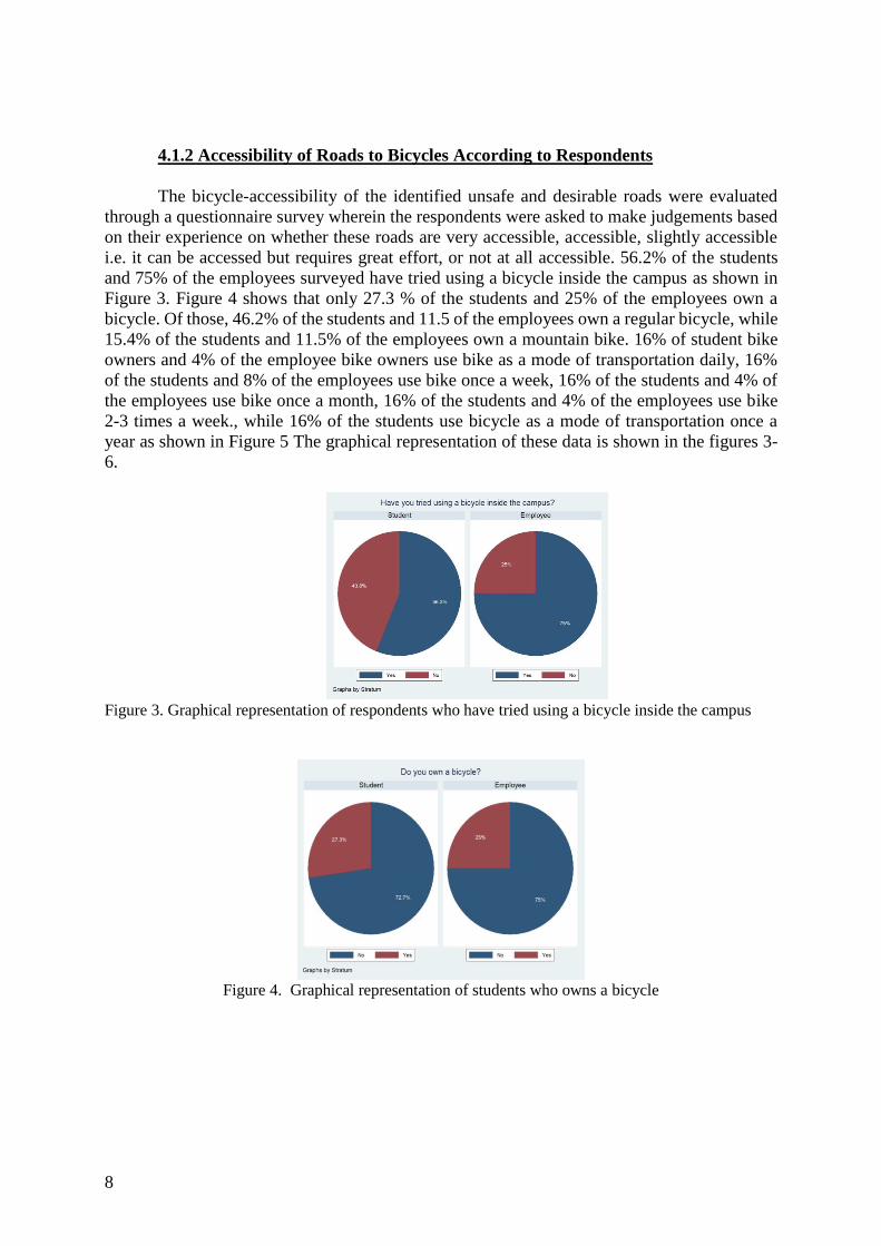
4.1.2 Accessibility of Roads to Bicycles According to Respondents
The bicycle-accessibility of the identified unsafe and desirable roads were evaluated
through a questionnaire survey wherein the respondents were asked to make judgements based
on their experience on whether these roads are very accessible, accessible, slightly accessible
i.e. it can be accessed but requires great effort, or not at all accessible. 56.2% of the students
and 75% of the employees surveyed have tried using a bicycle inside the campus as shown in
Figure 3. Figure 4 shows that only 27.3 % of the students and 25% of the employees own a
bicycle. Of those, 46.2% of the students and 11.5 of the employees own a regular bicycle, while
15.4% of the students and 11.5% of the employees own a mountain bike. 16% of student bike
owners and 4% of the employee bike owners use bike as a mode of transportation daily, 16%
of the students and 8% of the employees use bike once a week, 16% of the students and 4% of
the employees use bike once a month, 16% of the students and 4% of the employees use bike
2-3 times a week., while 16% of the students use bicycle as a mode of transportation once a
year as shown in Figure 5 The graphical representation of these data is shown in the figures 3-
6.
Figure 3. Graphical representation of respondents who have tried using a bicycle inside the campus
Figure 4. Graphical representation of students who owns a bicycle

9
Figure 5. Respondent's responses on how often they use bicycles
Data in Figure 5 implies that some of the respondents who own bicycles do not regularly use
their bicycles as a mode of transportation around campus. This can be explained by the distances
of their respective homes and boarding houses to the campus with an average of around 3
kilometers. Those who regularly or more frequently use their bicycles in transporting around
campus are those who are situated nearer or inside the campus.
Figure 6. Respondent’s responses on the type of bicycle they own
Responses of those who have tried using bicycles were analyzed as to their driving experience
inside the campus. This will also be a basis for the route determination of the proposed system.
Majority of the respondents (38.1 % of the students and 45.5% of the employees) indicated that
the uphill road from VSU Ecopark to DLABS is slightly accessible, 25% of the students and
18.2% of the employees stated that it is not accessible by a bicycle, 19% of the students and
18.2% of the employees said that it is accessible, and 17.9% of the students and 18.2 % of the
employees stated that the said road is very accessible. Most of the respondents (54.5% of the
employees and 33.3% of the students) indicated that the road fronting DLABS, Molave,
Mariposa and Mulberry Dormitories, or Cocofed street is very accessible by bicycles, while
17.9% of the students, 9.09% of the employees said that it is slightly accessible, and only 2.38%
of the students and none of the employees said that cocofed street is not accessible by bicycles.
Other road sections in VSU considered not safe in the technical analysis were also assessed by
the respondents. Graphical representation of their answers can be seen in figures 7 and 8. Figure
9 summarizes all the responses about where they think a road is accessible by a bicycle as
overlaid in the VSU map.

10
Figure 7. Response of students on the accessibility of selected roads to bicycle
Figure 8. Response of employees on the accessibility of selected roads to bicycle
Figure 9. Summary of responses on bicycle accessibility as shown in map

11
4.1.3 Determination of Level of Service (LOS) at the unsignalized intersection
The busiest road section in VSU is the intersection between the road connecting its lower
and upper campus and the Baybay-Inopacan Road (Figure 10). The intersection is a four-legged
unsignalized intersection with a speed limit of 40 kilometers per hour on the major road. An
analysis on the unsignalized intersection was done on this intersection to determine the reserve
capacity of the area to become the basis if the addition of the fleet of bicycles to be used in the
bike sharing program will have an effect to the traffic flow in the area.
Figure 10. Major unsignalized intersection in VSU
Traffic counts were done using a video recorder for 12 hours and the manual count of
vehicles was later done in the laboratory. Traffic data were gathered during the morning, noon,
and afternoon peak at 6:30 AM to 8:30 AM, 11:30A M – 1:30 PM, and from 4:30 PM – 6:00
PM, respectively. Data were gathered for 2 days on March 19, 2019 (Tuesday) and March 20,
2019 (Wednesday). It was assumed that the maximum number of vehicles will be recorded on
a weekday since the study area is in a university setting. Shown in table 2 is the sample of the
tabulated data while figure 11 shows the diagram of the movements in the intersection.
Table 2. Traffic count data
M1 M2 M3 M4 M5 M6 M7 M8 M9 M10 M11 M12
MOTORCYCLE 468 744 630 336 684 762 1626 1080 2058 510 1896 318
CAR 192 330 336 168 336 288 912 906 222 54 186 24
TRUCK 0 0 0 0 0 6 126 186 6 0 12 0
BUS 0 0 0 0 0 6 30 12 0 0 6 0
BIKE 6 42 0 12 144 42 0 12 6 24 6 6
TRICYCLE 6 0 12 24 6 18 72 90 12 12 18 0
TOTAL 672 1116 978 540 1170 1122 2766 2286 2304 600 2124 348
TOTAL (veh/hr) 56 93 81.5 45 97.5 93.5 230.5 190.5 192 50 177 29
M1 M2 M3 M4 M5 M6 M7 M8 M9 M10 M11 M12
MOTORCYCLE 300 942 822 390 1056 648 1512 1272 2286 630 2286 450
CAR 126 300 234 96 282 156 912 786 258 60 216 102
TRUCK 0 0 0 0 18 6 294 120 6 6 0 6
BUS 6 0 0 6 0 6 54 42 0 6 0 0
BIKE 30 54 6 6 84 6 24 24 30 24 0 18
TRICYCLE 0 0 30 6 0 6 19 84 24 18 24 0
TOTAL 462 1296 1092 504 1440 828 2815 2328 2604 744 2526 576
TOTAL (veh/hr) 38.5 108 91 42 120 69 234.5833 194 217 62 210.5 48
TUESDAY MOVEMENT (veh/12hr)
WEDNESDAY MOVEMENT (veh/12hr)

12
Figure 11. Traffic movements diagram
The method used in the analysis of the unsignalized intersection is based in the US
Highway Capacity Manual with some modifications as presented by Sigua in 2008 in his book
Fundamentals of Traffic Engineering. The method calculates the maximum flow in any given
minor road traffic stream. It is then compared with the existing traffic flow to estimate the
reserve capacity. The probable delay and level of service are determined based on the reserve
capacity.
The method requires that the traffic movements be dealt with in the following order:
a. Right turns into major road
b. Left turns off the major road
c. Traffic crossing the major road
d. Left turns into the major road
The capacity of one movement is determined by solving first the volume of the structure of the
major road (Mh) and the critical gap. Congestion in the major road is also considered if a traffic
stream turning off the major road becomes congested and will interfere with the minor road
traffic. In this case, the capacity is reduced. Another consideration are shared lanes. This
happens when two or more movements are confined in the same lane. Passenger car equivalents
are also considered before the reserve capacity is computed. The level of service is determined
from the value of the reserve capacity as shown in Table 3.
Table 3. Level of Service for unsignalized intersection
Reserve Capacity Description Level of Service
>600 Free flow, no traffic delay A
251-600 Stable flow, very short traffic delay B
176-250 Stable flow, short traffic delay C
126-175 Approaching unstable flow, average
traffic delay
C to D
76-125 Long traffic delay D
0-75 Unstable flow, very long traffic delay E
<0 Forced flow, congestion F
The results of the analysis for the East-West and West-East direction is shown in tables 4 and
5, respectively. The left turn into major road in the West-East direction showed the lowest
reserve capacity among the 8 movements with a reserve capacity of 149 pcu/hr and a level of
service of C-D. This shows that any additional volume in the system can still be tolerated by

13
the intersection. Also, it can be seen that all other movements have very high values of reserve
capacity with a Level of Service of A.
Table 4. Level of Service Analysis of East-West Direction
East-West Direction
March 19 March 20 March 19 March 20
Reserve
Capacity
(pcu/hr)
Reserve
Capacity
(pcu/hr)
Level of
Service
Level of
Service
Right turn into major road 766 909 A A
Left turn off major road 872 860 A A
Crossing major road 277 274 B B
Left turn into major road 200 230 C C
Table 5. Level of Service Analysis of West-East Direction
West-East direction
March 19 March 20 March
19
March 20
Reserve
Capacity
(pcu/hr)
Reserve
Capacity
(pcu/hr)
Level of
Service
Level of
Service
Right turn into major road 893 866 A A
Left turn off major road 788 751 A A
Crossing major road 310 301 B B
Left turn into major road 149 134 C to D C to D
4.1.4 Availability of Land Area inside VSU
A bike-sharing system requires an adequate land space where the stations will be placed.
The size of the land space required depends on the number and size of stations. By conducting
a field survey, it was found out that there are a lot of available spaces that can be found inside
the campus. Moreover, the proponents also consulted with the General Services Division (GSD)
office and asked if the land areas are available. They were able to confirm that it is possible to
place the stations in the suggested areas. Therefore, in terms of the availability of land area, a
bike-sharing system is feasible.
4.1.5. Station Locations
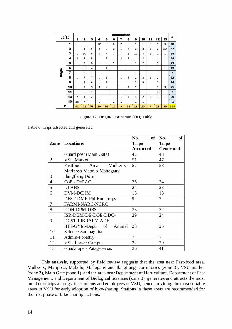
The origin-destination (OD) table shown in Figure 12 shows the trips from one zone to
another within the study area. The end rows show the total number of trips generated by each
zone, while the end columns show the total number of trips attracted by each zone. The total
number of trips attracted and generated by each zone is summarized in Table 6.
14
Figure 12. Origin-Destination (OD) Table
Table 6. Trips attracted and generated
This analysis, supported by field review suggests that the area near Fast-food area,
Mulberry, Mariposa, Mabolo, Mahogany and IlangIlang Dormitories (zone 3), VSU market
(zone 2), Main Gate (zone 1), and the area near Department of Horticulture, Department of Pest
Management, and Department of Biological Sciences (zone 8), generates and attracts the most
number of trips amongst the students and employees of VSU, hence providing the most suitable
areas in VSU for early adoption of bike-sharing. Stations in these areas are recommended for
the first phase of bike-sharing stations.
1 2 3 4 5 6 7 8 9 10 11 12 13
1 1 12 6 5 2 8 1 1 2 1 9 48
2 1 6 2 2 2 1 4 2 3 1 3 20 47
3 1 10 8 5 7 3 5 12 4 1 1 1 58
4 3 3 5 2 1 2 2 1 3 1 1 24
5 1 4 9 1 2 1 1 2 2 23
6 1 6 4 1 1 13
7 1 3 1 1 1 7
8 1 7 7 1 1 1 6 2 2 1 3 32
9 1 3 6 1 3 2 5 3 24
10 1 4 3 3 2 4 2 3 3 25
11 1 2 1 3 7
12 2 1 2 1 4 4 2 2 1 1 20
13 28 7 1 2 1 1 1 41
42 51 52 26 24 15 9 33 29 23 7 22 36 369
O/DDestination
Σ
Origin
Σ
Zone Locations
No. of
Trips
Attracted
No. of
Trips
Generated
1 Guard post (Main Gate) 42 48
2 VSU Market 51 47
3
Fastfood Area -Mulberry-
Mariposa-Mabolo-Mahogany-
IlangIlang Dorm
52 58
4 CoE - DoPAC 26 24
5 DLABS 24 23
6 DVM-DCHM 15 13
7
DFST-DME-PhilRootcrops-
FARMI-NARC-NCRC
9 7
8 DOH-DPM-DBS 33 32
9
ISR-DBM-DE-DOE-DDC-
DCST-LIBRARY-ADE
29 24
10
IHK-GYM-Dept. of Animal
Science-Sampaguita
23 25
11 Admin-Forestry 7 7
12 VSU Lower Campus 22 20
13 Guadalupe - Patag-Gabas 36 41

15
The area near ISRDS, Departments of Business Management, Economics, Education,
Development Communication, Computer Science and Technology, ADE, and the new
university library (zone 9), College of Engineering and Dept. of Pure and Applied Chemistry
(zone 4), Dept. of Liberal Arts and Behavioral Sciences (zone 5), Institute of Human Kinetics,
Gymnasium, Dept. of Animal Science and Sampaguita Dormitory (zone 10) generates a
sufficient number of trips. Putting-up stations within these zones could generate a sufficient
density of potential users likely to embrace bike-sharing. It is recommended that these areas be
introduced as part of the phase 2 expansion of the system.
A recommended third phase would expand the system into the areas near the Dept. of
Food, Science and Technology, Dept. of Mechanical Engineering, National Coconut Research
Center, Phil Root crops, Farmi, National Abaca and Research Center (zone 7), VSU
Administration Bldg, College of Forestry (zone 11), Dept. of Veterinary Medicine and Dept. of
Hotel, Tourism and Management (zone 6), and VSUIHS (zone 12). Lower ridership can be
expected in these areas, however, it is necessary to provide stations in these zones because of
their distances which makes bicycling a more attractive option than walking. Exact proposed
locations and phasing implementatin of the stations are shown in figure 13.
Figure 13. Proposed locations of stations and phasing implementation
4.2 Social Study
As part of the feasibility study, a questionnaire survey was conducted to gauge interest
in a bike-sharing program at Visayas State University. With the approval of the University
Registrar, and Director of ODAHD, the proponents were able to gather the population data of
the students and employees in VSU. Stratified random sampling was used as a sampling method
since it would allow the researchers to obtain a sample population that best represents the entire
population.
Graphical representations of the results of the survey are shown in the figures below.
44.9% of the students, and 16.7% of the employees said they will extremely likely use bicycle
as a mode of transportation inside the campus, 42.7% of the students and 75% of the employees

16
said they will likely use bicycle as a mode of transportation. Only 12.4% of the students, and
8.33% of the employees said will not likely use bicycle as a mode of transportation inside the
campus, if there’s a bike-sharing system.
As opposed to the data shown in Figure 5 where only 16% of the students and 4% of the
employees use bicycle as a mode of transportation every day, a huge shift in interest was
observed. It was shown earlier that even those who own bicycles do not use it regularly. It was
explained by the distances of their respective homes and boarding houses to the campus with
an average of around 3 kilometers. Those who regularly or more frequently use their bicycles
in transporting around campus are those who are situated nearer or inside the campus. With the
proposed bike-sharing system, the huge shift of interest can be due to the reason that bicycles
are already within the campus and they do not need to bring it to and from their respective
houses. Issues of bicycle maintenance can also be a plausible reason of the shift of mindset.
Figure 12. Responses when asked if they are going to use the bicycle to transport around campus
Majority of the students (57.3%) and employees (66.7%) or approximately 3773
students and employees would likely use the bike-sharing system, 36% of the students and 25%
of the employees or approximately 2239 students and employees said that they would extremely
likely use the program, while 5.62% of the students and 8.33% of the employees, or
approximately 384 answered ‘not likely’ and only 1.12% of the students, approximately 64
students and none of the employees answered ‘extremely unlikely’.
Figure 13. Responses on the likelihood of using the proposed bike sharing system if implemented
17
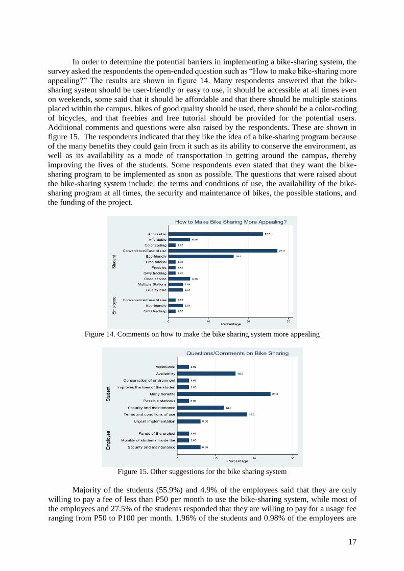
In order to determine the potential barriers in implementing a bike-sharing system, the
survey asked the respondents the open-ended question such as “How to make bike-sharing more
appealing?” The results are shown in figure 14. Many respondents answered that the bike-
sharing system should be user-friendly or easy to use, it should be accessible at all times even
on weekends, some said that it should be affordable and that there should be multiple stations
placed within the campus, bikes of good quality should be used, there should be a color-coding
of bicycles, and that freebies and free tutorial should be provided for the potential users.
Additional comments and questions were also raised by the respondents. These are shown in
figure 15. The respondents indicated that they like the idea of a bike-sharing program because
of the many benefits they could gain from it such as its ability to conserve the environment, as
well as its availability as a mode of transportation in getting around the campus, thereby
improving the lives of the students. Some respondents even stated that they want the bike-
sharing program to be implemented as soon as possible. The questions that were raised about
the bike-sharing system include: the terms and conditions of use, the availability of the bike-
sharing program at all times, the security and maintenance of bikes, the possible stations, and
the funding of the project.
Figure 14. Comments on how to make the bike sharing system more appealing
Figure 15. Other suggestions for the bike sharing system
Majority of the students (55.9%) and 4.9% of the employees said that they are only
willing to pay a fee of less than P50 per month to use the bike-sharing system, while most of
the employees and 27.5% of the students responded that they are willing to pay for a usage fee
ranging from P50 to P100 per month. 1.96% of the students and 0.98% of the employees are

18
willing to pay a monthly usage fee ranging from P101 to P150, 1.96% of the students said that
they are willing to pay P151-P200 per month, and only 0.98% of the students are willing to pay
for a monthly usage fee ranging from P201 to P250. The graphical representation of the results
is shown in figure 16.
Figure 16. Preferred usage fee of users per month.
Based on the results of the factor analysis, the following features are considered to be important
in implementing a Bike-Sharing Program according to the respondents. They also stated that
having these features would make them interested in using the proposed Bike-Sharing System.
Table 7. Important features for a bike sharing system according to stakeholders
Factor 1:
Electronic bike kiosk around campus
24-hour access to bikes
GPS technology to track location of bikes online
Factor 2:
Ability to reserve bikes by smartphones or computer
Flexible membership options
Flexibility to use bikes for long or short term
Attendant monitored bike storage
Factor 3:
Flexibility to return bikes to any location
Multiple locations
Having someone else be responsible for the maintenance of the bikes Cost
effectiveness
Factor 4:
Short term rentals (day, hour, or week)
One-time paid membership and unlimited access
Variety in sizes and types of bikes
Single central location
Factor 5:
High number of bikes available at all times Brand new bikes

19
5. CONCLUSION
5.1 Summary
This paper presented considerations in the preliminary study of a bicycle sharing system at
Visayas State University. The proposed project is considered feasible based on the technical
and social aspect. Technical aspects include road safety, accessibility of roads to bicycles,
availability of land area for operation, traffic study to analyze the roadway capacity, and
proposed stations. The social study includes the determination whether the campus community
has sufficient interest in a bicycle-sharing system to pursue such a program.
5.2 Findings
5.2.1 Technical Analysis
As shown in Figures 2 and 9, the whole VSU community can be connected by routes
considered safe through the slope requirements and previous experiences of bike users. The
traffic analysis showed that the proposed additional volume by the bicycles will not cause
congestion specially in the critical main intersection in VSU. The O-D survey showed the trips
generated and attracted in each zone in VSU and became a basis for proposed stations locations.
5.2.2 Social Survey
The study shows that only 12.4% of the students, and 8.33% of the employees will not likely
use bicycle as a mode of transportation inside the campus if there’s a bike-sharing system. The
important features of the bike-sharing system according to the respondents was also noted.
5.3 Recommendations
The preliminary study showed that a bike-sharing system can be implemented in VSU based
on the criteria. It also showed that there is a sufficient interest of users willing to use the system.
The next study must look at the implementation details of the bike-sharing system. The
system must tackle the important features described by the respondents.
The parameters of a bike share system are also directly tied to the amount of available
funding and the goals of the system. The amount of available capital generally dictates the size
of the system. With this, a detailed financial study of the proposed system must be conducted.

20
6. REFERENCES
1. Babiano, Public Bicycle Sharing In Asian Cities, Journal of the Eastern Asia Society for
Transportation Studies, Vol.11, 2015
2. Chen, F., Turon, K., Kłos, M., Czech, P., Pamuła, W., Sierpinski, G. Fifth-generation
bike- sharing systems: examples from Poland and China. Scientific Journal of Silesian
University of Technology. Series Transport. 2018, 99, 05-13. ISSN: 0209-3324.
DOI: https://doi.org/10.20858/sjsutst.2018.99.1.
3. DPWH Road Safety Design Manual
4. Heda, A. (2012) Implementation of a Bike Sharing Program on Washington
University’s Danforth Campus
5. Highway Capacity Manual 2000, Transportation Research Board, Washington, D.C.,
2000.
6. Midgley Peter. 2011. “Bicycle-sharing schemes: enhancing sustainable mobility in
urban areas”. Background Paper No. 8 CSD19/2011/BP8: 1-26. New York: United
Nations Department of Economic and Social Affairs.
7. Rojas-Rueda, D. (2011) The health risks and benefits of cycling in urban environments
8. Shaheen Susan Stacey Guzman, Hua Zhang. 2010. “Bikesharing in Europe, the
Americas, and Asia: past, present, and future”. Transportation Research Record:
Journal of the Transportation Research Board 2143:1-20. ISSN: 0361-1981. DOI:
https://doi.org/10.3141/2143-20.
9. Sigua, Ricardo G., Fundamentals of Traffic Engineering, Quezon City: The University
of the Philippines Press, c2008