PRELIMINARY STAFFORD - Dallas City Hall...2019/07/11 · N59 27'08"E 135.17' S30 44'19"E 165.00'...
1
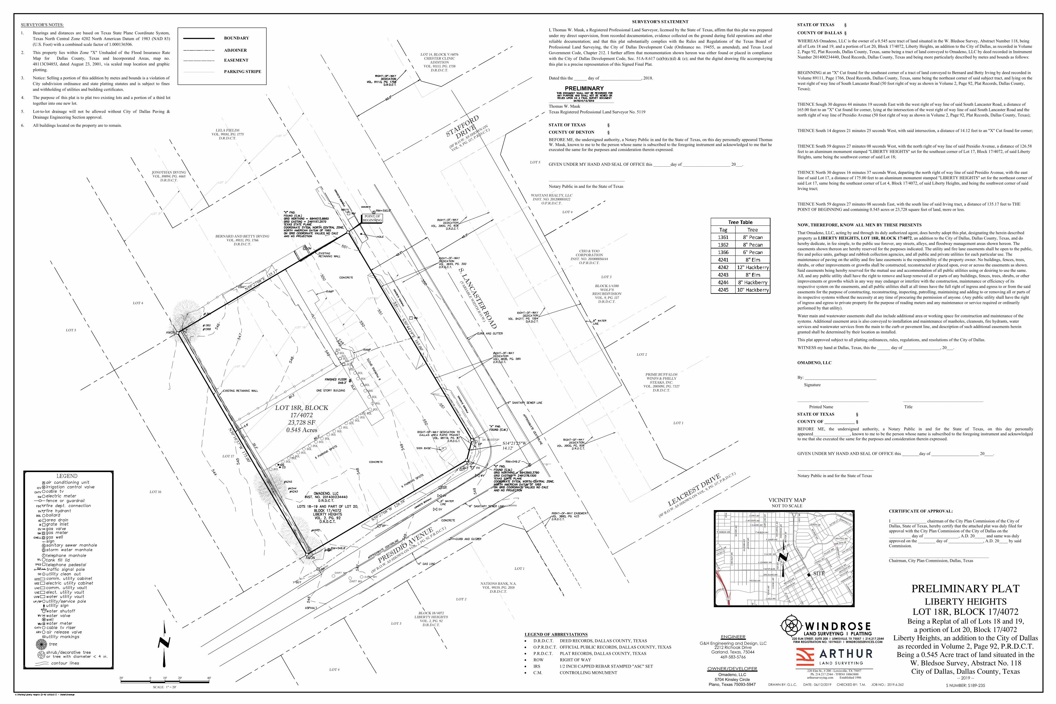
LOT 18R, BLOCK 17/4072 23,728 SF 0.545 Acres LOT 17 LOT 4 OU OU OU OU OU OU OU OU OU OU OU OU OU OU OU OU OU OU OU OU OU OU OU OU OU OU OU OU OU OU OU OU OU PRESIDIO AVENUE (50' R.O.W. AS SHOWN ON VOL. 2, PG. 92, P.R.D.C.T.) S. LANCASTER ROAD (VARIABLE WIDTH R.O.W.) LOT 16 LOT 5 N59°27'08"E 135.17' S30°44'19"E 165.00' S14°21'25"W 14.12' S59°27'08"W 126.58' N30°16'37"W 175.00' WASTANI REALTY, LLC INST. NO. 201200081822 O.P.R.D.C.T. BERNARD AND BETTY IRVING VOL. 89111, PG. 1766 D.R.D.C.T. LELA FIELDS VOL. 99181, PG. 1775 D.R.D.C.T. JONOTHAN IRVING VOL. 89094, PG. 4665 D.R.D.C.T. POINT OF BEGINNING NATIONS BANK, N.A. VOL. 99119, PG. 2018 D.R.D.C.T. LOT 1 LOT 2 LOT 3 LOT 4 BLOCK 18/4072 LIBERTY HEIGHTS VOL. 2, PG. 92 D.R.D.C.T. BLOCK 1/4380 WOLF'S RESUBDIVISION VOL. 9, PG. 117 D.R.D.C.T. LOT 1 LOT 2 LOT 3 LOT 4 LOT 5 CHO & YOO CORPORATION INST. NO. 201000056144 O.P.R.D.C.T. PRIME BUFFALOS WINFS & PHILLY STEAKS, INC. VOL. 2005091, PG. 7327 D.R.D.C.T. LOT 14, BLOCK V/6076 CHESTER CLINIC ADDITION VOL. 91113, PG. 1758 D.R.D.C.T. LEACREST DRIVE (50' R.O.W. AS SHOWN ON VOL. 9, PG. 117, P.R.D.C.T.) STAFFORD DRIVE (50' R.O.W. AS SHOWN ON VOL. 9, PG. 117, P.R.D.C.T.) PRELIMINARY PLAT LIBERTY HEIGHTS LOT 18R, BLOCK 17/4072 Being a Replat of all of Lots 18 and 19, a portion of Lot 20, Block 17/4072 Liberty Heights, an addition to the City of Dallas as recorded in Volume 2, Page 92, P.R.D.C.T. Being a 0.545 Acre tract of land situated in the W. Bledsoe Survey, Abstract No. 118 City of Dallas, Dallas County, Texas -- 2019 -- OWNER/DEVELOPER Omadeno, LLC 5704 Kinsley Circle Plano, Texas 75093-5947 ENGINEER 469-583-5766 Garland, Texas, 75044 2212 Richoak Drive G&H Engineering and Design, LLC SURVEYOR'S NOTES: 1. Bearings and distances are based on Texas State Plane Coordinate System, Texas North Central Zone 4202 North American Datum of 1983 (NAD 83) (U.S. Foot) with a combined scale factor of 1.000136506. 2. This property lies within Zone "X" Unshaded of the Flood Insurance Rate Map for Dallas County, Texas and Incorporated Areas, map no. 48113C0485J, dated August 23, 2001, via scaled map location and graphic plotting. 3. Notice: Selling a portion of this addition by metes and bounds is a violation of City subdivision ordinance and state platting statutes and is subject to fines and withholding of utilities and building certificates. 4. The purpose of this plat is to plat two existing lots and a portion of a third lot together into one new lot. 5. Lot-to-lot drainage will not be allowed without City of Dallas Paving & Drainage Engineering Section approval. 6. All buildings located on the property are to remain. STATE OF TEXAS COUNTY OF DALLAS WHEREAS Omadeno, LLC is the owner of a 0.545 acre tract of land situated in the W. Bledsoe Survey, Abstract Number 118, being all of Lots 18 and 19, and a portion of Lot 20, Block 17/4072, Liberty Heights, an addition to the City of Dallas, as recorded in Volume 2, Page 92, Plat Records, Dallas County, Texas, same being a tract of land conveyed to Omadeno, LLC by deed recorded in Instrument Number 201400234440, Deed Records, Dallas County, Texas and being more particularly described by metes and bounds as follows: BEGINNING at an "X" Cut found for the southeast corner of a tract of land conveyed to Bernard and Betty Irving by deed recorded in Volume 89111, Page 1766, Deed Records, Dallas County, Texas, same being the northeast corner of said subject tract, and lying on the west right of way line of South Lancaster Road (50 foot right of way as shown in Volume 2, Page 92, Plat Records, Dallas County, Texas); THENCE Sough 30 degrees 44 minutes 19 seconds East with the west right of way line of said South Lancaster Road, a distance of 165.00 feet to an "X" Cut found for corner, lying at the intersection of the west right of way line of said South Lancaster Road and the north right of way line of Presidio Avenue (50 foot right of way as shown in Volume 2, Page 92, Plat Records, Dallas County, Texas); THENCE South 14 degrees 21 minutes 25 seconds West, with said intersection, a distance of 14.12 feet to an "X" Cut found for corner; THENCE South 59 degrees 27 minutes 08 seconds West, with the north right of way line of said Presidio Avenue, a distance of 126.58 feet to an aluminum monument stamped "LIBERTY HEIGHTS" set for the southeast corner of Lot 17, Block 17/4072, of said Liberty Heights, same being the southwest corner of said Lot 18; THENCE North 30 degrees 16 minutes 37 seconds West, departing the north right of way line of said Presidio Avenue, with the east line of said Lot 17, a distance of 175.00 feet to an aluminum monument stamped "LIBERTY HEIGHTS" set for the northeast corner of said Lot 17, same being the southeast corner of Lot 4, Block 17/4072, of said Liberty Heights, and being the southwest corner of said Irving tract; THENCE North 59 degrees 27 minutes 08 seconds East, with the south line of said Irving tract, a distance of 135.17 feet to THE POINT OF BEGINNING and containing 0.545 acres or 23,728 square feet of land, more or less. NOW, THEREFORE, KNOW ALL MEN BY THESE PRESENTS That Omadeno, LLC, acting by and through its duly authorized agent, does hereby adopt this plat, designating the herein described property as LIBERTY HEIGHTS, LOT 18R, BLOCK 17/4072, an addition to the City of Dallas, Dallas County, Texas, and do hereby dedicate, in fee simple, to the public use forever, any streets, alleys, and floodway management areas shown hereon. The easements shown thereon are hereby reserved for the purposes indicated. The utility and fire lane easements shall be open to the public, fire and police units, garbage and rubbish collection agencies, and all public and private utilities for each particular use. The maintenance of paving on the utility and fire lane easements is the responsibility of the property owner. No buildings, fences, trees, shrubs, or other improvements or growths shall be constructed, reconstructed or placed upon, over or across the easements as shown. Said easements being hereby reserved for the mutual use and accommodation of all public utilities using or desiring to use the same. All, and any public utility shall have the right to remove and keep removed all or parts of any buildings, fences, trees, shrubs, or other improvements or growths which in any way may endanger or interfere with the construction, maintenance or efficiency of its respective system on the easements, and all public utilities shall at all times have the full right of ingress and egress to or from the said easements for the purpose of constructing, reconstructing, inspecting, patrolling, maintaining and adding to or removing all or parts of its respective systems without the necessity at any time of procuring the permission of anyone. (Any public utility shall have the right of ingress and egress to private property for the purpose of reading meters and any maintenance or service required or ordinarily performed by that utility). Water main and wastewater easements shall also include additional area or working space for construction and maintenance of the systems. Additional easement area is also conveyed to installation and maintenance of manholes, cleanouts, fire hydrants, water services and wastewater services from the main to the curb or pavement line, and description of such additional easements herein granted shall be determined by their location as installed. This plat approved subject to all platting ordinances, rules, regulations, and resolutions of the City of Dallas. WITNESS my hand at Dallas, Texas, this the ______ day of _________________, 20___. OMADENO, LLC By: _________________________________ Signature __________ ______________________ _____________________________________ Printed Name Title STATE OF TEXAS COUNTY OF ______________ BEFORE ME, the undersigned authority, a Notary Public in and for the State of Texas, on this day personally appeared_________________, known to me to be the person whose name is subscribed to the foregoing instrument and acknowledged to me that she executed the same for the purposes and consideration therein expressed. GIVEN UNDER MY HAND AND SEAL OF OFFICE this ________day of ______________________ 20____. ___________________________________ Notary Public in and for the State of Texas VICINITY MAP NOT TO SCALE SCALE: 1" = 20' 20' 0 10' 20' 40' LEGEND OF ABBREVIATIONS · D.R.D.C.T. DEED RECORDS, DALLAS COUNTY, TEXAS · O.P.R.D.C.T. OFFICIAL PUBLIC RECORDS, DALLAS COUNTY, TEXAS · P.R.D.C.T. PLAT RECORDS, DALLAS COUNTY, TEXAS · ROW RIGHT OF WAY · IRS 1/2 INCH CAPPED REBAR STAMPED "ASC" SET · C.M. CONTROLLING MONUMENT PRELIMINARY SURVEYOR'S STATEMENT I, Thomas W. Mauk, a Registered Professional Land Surveyor, licensed by the State of Texas, affirm that this plat was prepared under my direct supervision, from recorded documentation, evidence collected on the ground during field operations and other reliable documentation; and that this plat substantially complies with the Rules and Regulations of the Texas Board of Professional Land Surveying, the City of Dallas Development Code (Ordinance no. 19455, as amended), and Texas Local Government Code, Chapter 212. I further affirm that monumentation shown hereon was either found or placed in compliance with the City of Dallas Development Code, Sec. 51A-8.617 (a)(b)(c)(d) & (e); and that the digital drawing file accompanying this plat is a precise representation of this Signed Final Plat. Dated this the ______ day of ___________________, 2018. ______________________________ Thomas W. Mauk Texas Registered Professional Land Surveyor No. 5119 STATE OF TEXAS COUNTY OF DENTON BEFORE ME, the undersigned authority, a Notary Public in and for the State of Texas, on this day personally appeared Thomas W. Mauk, known to me to be the person whose name is subscribed to the foregoing instrument and acknowledged to me that he executed the same for the purposes and consideration therein expressed. GIVEN UNDER MY HAND AND SEAL OF OFFICE this ________day of ______________________ 20___. ___________________________________ Notary Public in and for the State of Texas CERTIFICATE OF APPROVAL: I ________________ chairman of the City Plan Commission of the City of Dallas, State of Texas, hereby certify that the attached plat was duly filed for approval with the City Plan Commission of the City of Dallas on the __________ day of ________________, A.D. 20_____ and same was duly approved on the ________ day of ________________, A.D. 20____ by said Commission. ______________________________________________ Chairman, City Plan Commission, Dallas, Texas DRAWN BY: G.L.C. DATE: 06/12/2019 CHECKED BY: T.M. JOB NO.: 2019.6.262 220 ELM STREET, SUITE 200 I LEWISVILLE, TX 75057 I 214.217.2544 FIRM REGISTRATION NO. 10194331 I WINDROSESERVICES.COM I LAND SURVEYING PLATTING WINDROSE 220 Elm St., # 200 - Lewisville, TX 75057 Ph. 214.217.2544 - TFRN# 10063800 arthursurveying.com Established 1986 BOUNDARY ADJOINER EASEMENT PARKING STRIPE SITE S NUMBER: S189-235
Transcript of PRELIMINARY STAFFORD - Dallas City Hall...2019/07/11 · N59 27'08"E 135.17' S30 44'19"E 165.00'...
LOT 18R, BLOCK17/4072
23,728 SF0.545 Acres
LOT 17
LOT 4
OU
OU
OU
OU
OU
OU
OU
OU
OU
OU
OU
OU
OU
OU
OU
OU
OU
OU
OU
OU
OU
OU
OU
OU
OU
OU
OU
OU
OU
OU
OU
OU
OU
PRESIDIO
AVENUE
(50' R.O.W
. AS SHOWN ON VOL. 2, P
G. 92, P.R.D.C.T.)
S. LA
NC
AST
ER
RO
AD
(VA
RIA
BL
E W
IDT
H R
.O.W
.)
LOT 16
LOT 5
N59°27'08"E 135.17'
S30°44'19"E 165.00'
S14°21'25"W14.12'
S59°27'08"W 126.58'
N30°16'37"W 175.00'
WASTANI REALTY, LLCINST. NO. 201200081822
O.P.R.D.C.T.
BERNARD AND BETTY IRVINGVOL. 89111, PG. 1766
D.R.D.C.T.
LELA FIELDSVOL. 99181, PG. 1775
D.R.D.C.T.
JONOTHAN IRVINGVOL. 89094, PG. 4665
D.R.D.C.T.
POINT OFBEGINNING
NATIONS BANK, N.A.VOL. 99119, PG. 2018
D.R.D.C.T.
LOT 1
LOT 2
LOT 3
LOT 4
BLOCK 18/4072LIBERTY HEIGHTS
VOL. 2, PG. 92D.R.D.C.T.
BLOCK 1/4380WOLF'S
RESUBDIVISIONVOL. 9, PG. 117
D.R.D.C.T.
LOT 1
LOT 2
LOT 3
LOT 4
LOT 5
CHO & YOOCORPORATION
INST. NO. 201000056144O.P.R.D.C.T.
PRIME BUFFALOSWINFS & PHILLY
STEAKS, INC.VOL. 2005091, PG. 7327
D.R.D.C.T.
LOT 14, BLOCK V/6076CHESTER CLINIC
ADDITIONVOL. 91113, PG. 1758
D.R.D.C.T.
LEACREST DRIVE
(50' R.O.W
. AS SHOWN ON VOL. 9, PG. 11
7, P.R.D.C.T.)
STAFFORD
DRIVE
(50' R.O.W
. AS SHOWN ON
VOL. 9, PG. 117, P.R.D.C.T.)
PRELIMINARY PLATLIBERTY HEIGHTS
LOT 18R, BLOCK 17/4072Being a Replat of all of Lots 18 and 19,
a portion of Lot 20, Block 17/4072Liberty Heights, an addition to the City of Dallas
as recorded in Volume 2, Page 92, P.R.D.C.T.Being a 0.545 Acre tract of land situated in the
W. Bledsoe Survey, Abstract No. 118City of Dallas, Dallas County, Texas
-- 2019 --
OWNER/DEVELOPEROmadeno, LLC
5704 Kinsley Circle
Plano, Texas 75093-5947
ENGINEER
469-583-5766Garland, Texas, 75044
2212 Richoak DriveG&H Engineering and Design, LLC
SURVEYOR'S NOTES:
1. Bearings and distances are based on Texas State Plane Coordinate System,Texas North Central Zone 4202 North American Datum of 1983 (NAD 83)(U.S. Foot) with a combined scale factor of 1.000136506.
2. This property lies within Zone "X" Unshaded of the Flood Insurance RateMap for Dallas County, Texas and Incorporated Areas, map no.48113C0485J, dated August 23, 2001, via scaled map location and graphicplotting.
3. Notice: Selling a portion of this addition by metes and bounds is a violation ofCity subdivision ordinance and state platting statutes and is subject to finesand withholding of utilities and building certificates.
4. The purpose of this plat is to plat two existing lots and a portion of a third lottogether into one new lot.
5. Lot-to-lot drainage will not be allowed without City of Dallas Paving &Drainage Engineering Section approval.
6. All buildings located on the property are to remain.
STATE OF TEXAS §
COUNTY OF DALLAS §
WHEREAS Omadeno, LLC is the owner of a 0.545 acre tract of land situated in the W. Bledsoe Survey, Abstract Number 118, beingall of Lots 18 and 19, and a portion of Lot 20, Block 17/4072, Liberty Heights, an addition to the City of Dallas, as recorded in Volume2, Page 92, Plat Records, Dallas County, Texas, same being a tract of land conveyed to Omadeno, LLC by deed recorded in InstrumentNumber 201400234440, Deed Records, Dallas County, Texas and being more particularly described by metes and bounds as follows:
BEGINNING at an "X" Cut found for the southeast corner of a tract of land conveyed to Bernard and Betty Irving by deed recorded inVolume 89111, Page 1766, Deed Records, Dallas County, Texas, same being the northeast corner of said subject tract, and lying on thewest right of way line of South Lancaster Road (50 foot right of way as shown in Volume 2, Page 92, Plat Records, Dallas County,Texas);
THENCE Sough 30 degrees 44 minutes 19 seconds East with the west right of way line of said South Lancaster Road, a distance of165.00 feet to an "X" Cut found for corner, lying at the intersection of the west right of way line of said South Lancaster Road and thenorth right of way line of Presidio Avenue (50 foot right of way as shown in Volume 2, Page 92, Plat Records, Dallas County, Texas);
THENCE South 14 degrees 21 minutes 25 seconds West, with said intersection, a distance of 14.12 feet to an "X" Cut found for corner;
THENCE South 59 degrees 27 minutes 08 seconds West, with the north right of way line of said Presidio Avenue, a distance of 126.58feet to an aluminum monument stamped "LIBERTY HEIGHTS" set for the southeast corner of Lot 17, Block 17/4072, of said LibertyHeights, same being the southwest corner of said Lot 18;
THENCE North 30 degrees 16 minutes 37 seconds West, departing the north right of way line of said Presidio Avenue, with the eastline of said Lot 17, a distance of 175.00 feet to an aluminum monument stamped "LIBERTY HEIGHTS" set for the northeast corner ofsaid Lot 17, same being the southeast corner of Lot 4, Block 17/4072, of said Liberty Heights, and being the southwest corner of saidIrving tract;
THENCE North 59 degrees 27 minutes 08 seconds East, with the south line of said Irving tract, a distance of 135.17 feet to THEPOINT OF BEGINNING and containing 0.545 acres or 23,728 square feet of land, more or less.
NOW, THEREFORE, KNOW ALL MEN BY THESE PRESENTS
That Omadeno, LLC, acting by and through its duly authorized agent, does hereby adopt this plat, designating the herein describedproperty as LIBERTY HEIGHTS, LOT 18R, BLOCK 17/4072, an addition to the City of Dallas, Dallas County, Texas, and dohereby dedicate, in fee simple, to the public use forever, any streets, alleys, and floodway management areas shown hereon. Theeasements shown thereon are hereby reserved for the purposes indicated. The utility and fire lane easements shall be open to the public,fire and police units, garbage and rubbish collection agencies, and all public and private utilities for each particular use. Themaintenance of paving on the utility and fire lane easements is the responsibility of the property owner. No buildings, fences, trees,shrubs, or other improvements or growths shall be constructed, reconstructed or placed upon, over or across the easements as shown.Said easements being hereby reserved for the mutual use and accommodation of all public utilities using or desiring to use the same.All, and any public utility shall have the right to remove and keep removed all or parts of any buildings, fences, trees, shrubs, or otherimprovements or growths which in any way may endanger or interfere with the construction, maintenance or efficiency of itsrespective system on the easements, and all public utilities shall at all times have the full right of ingress and egress to or from the saideasements for the purpose of constructing, reconstructing, inspecting, patrolling, maintaining and adding to or removing all or parts ofits respective systems without the necessity at any time of procuring the permission of anyone. (Any public utility shall have the rightof ingress and egress to private property for the purpose of reading meters and any maintenance or service required or ordinarilyperformed by that utility).
Water main and wastewater easements shall also include additional area or working space for construction and maintenance of thesystems. Additional easement area is also conveyed to installation and maintenance of manholes, cleanouts, fire hydrants, waterservices and wastewater services from the main to the curb or pavement line, and description of such additional easements hereingranted shall be determined by their location as installed.
This plat approved subject to all platting ordinances, rules, regulations, and resolutions of the City of Dallas.
WITNESS my hand at Dallas, Texas, this the ______ day of _________________, 20___.
OMADENO, LLC
By: _________________________________
Signature
__________ ______________________ _____________________________________
Printed Name Title
STATE OF TEXAS §
COUNTY OF ______________ §
BEFORE ME, the undersigned authority, a Notary Public in and for the State of Texas, on this day personallyappeared_________________, known to me to be the person whose name is subscribed to the foregoing instrument and acknowledgedto me that she executed the same for the purposes and consideration therein expressed.
GIVEN UNDER MY HAND AND SEAL OF OFFICE this ________day of ______________________ 20____.
___________________________________
Notary Public in and for the State of Texas
VICINITY MAPNOT TO SCALE
SCALE: 1" = 20'
20' 0 10' 20' 40'
LEGEND OF ABBREVIATIONS· D.R.D.C.T. DEED RECORDS, DALLAS COUNTY, TEXAS· O.P.R.D.C.T. OFFICIAL PUBLIC RECORDS, DALLAS COUNTY, TEXAS· P.R.D.C.T. PLAT RECORDS, DALLAS COUNTY, TEXAS· ROW RIGHT OF WAY· IRS 1/2 INCH CAPPED REBAR STAMPED "ASC" SET· C.M. CONTROLLING MONUMENT
PRELIMINARY
SURVEYOR'S STATEMENT
I, Thomas W. Mauk, a Registered Professional Land Surveyor, licensed by the State of Texas, affirm that this plat was preparedunder my direct supervision, from recorded documentation, evidence collected on the ground during field operations and otherreliable documentation; and that this plat substantially complies with the Rules and Regulations of the Texas Board ofProfessional Land Surveying, the City of Dallas Development Code (Ordinance no. 19455, as amended), and Texas LocalGovernment Code, Chapter 212. I further affirm that monumentation shown hereon was either found or placed in compliancewith the City of Dallas Development Code, Sec. 51A-8.617 (a)(b)(c)(d) & (e); and that the digital drawing file accompanyingthis plat is a precise representation of this Signed Final Plat.
Dated this the ______ day of ___________________, 2018.
______________________________Thomas W. MaukTexas Registered Professional Land Surveyor No. 5119
STATE OF TEXAS §
COUNTY OF DENTON §
BEFORE ME, the undersigned authority, a Notary Public in and for the State of Texas, on this day personally appeared ThomasW. Mauk, known to me to be the person whose name is subscribed to the foregoing instrument and acknowledged to me that heexecuted the same for the purposes and consideration therein expressed.
GIVEN UNDER MY HAND AND SEAL OF OFFICE this ________day of ______________________ 20___.
___________________________________
Notary Public in and for the State of Texas
CERTIFICATE OF APPROVAL:
I ________________ chairman of the City Plan Commission of the City ofDallas, State of Texas, hereby certify that the attached plat was duly filed forapproval with the City Plan Commission of the City of Dallas on the__________ day of ________________, A.D. 20_____ and same was dulyapproved on the ________ day of ________________, A.D. 20____ by saidCommission.
______________________________________________Chairman, City Plan Commission, Dallas, Texas
DRAWN BY: G.L.C. DATE: 06/12/2019 CHECKED BY: T.M. JOB NO.: 2019.6.262
220 ELM STREET, SUITE 200 I LEWISVILLE, TX 75057 I 214.217.2544FIRM REGISTRATION NO. 10194331 I WINDROSESERVICES.COM
ILAND SURVEYING PLATTINGW I N D ROS E
220 Elm St., # 200 - Lewisville, TX 75057Ph. 214.217.2544 - TFRN# 10063800
arthursurveying.com Established 1986
BOUNDARY
ADJOINER
EASEMENT
PARKING STRIPE
SITE
S NUMBER: S189-235
AutoCAD SHX Text
CONCRETE
AutoCAD SHX Text
CONCRETE
AutoCAD SHX Text
CONCRETE
AutoCAD SHX Text
CONCRETE
AutoCAD SHX Text
CONCRETE
AutoCAD SHX Text
CONCRETE SIDEWALK
AutoCAD SHX Text
CONCRETE SIDEWALK
AutoCAD SHX Text
CONCRETE SIDEWALK
AutoCAD SHX Text
CONCRETE SIDEWALK
AutoCAD SHX Text
6 PARKING SPOTS
AutoCAD SHX Text
6 PARKING SPOTS
AutoCAD SHX Text
9 PARKING SPOTS
AutoCAD SHX Text
ONE STORY BUILDING
AutoCAD SHX Text
ASPHALT
AutoCAD SHX Text
LOTS 18-19 AND PART OF LOT 20, BLOCK 17/4072 LIBERTY HEIGHTS VOL. 2, PG. 92 D.R.D.C.T.
AutoCAD SHX Text
OMADENO, LLC INST. NO. 201400234440 D.R.D.C.T.
AutoCAD SHX Text
AMON
AutoCAD SHX Text
AMON
AutoCAD SHX Text
APPROXIMATE CENTERLINE
AutoCAD SHX Text
APPROXIMATE CENTERLINE
AutoCAD SHX Text
#1361
AutoCAD SHX Text
#1366
AutoCAD SHX Text
#1362
AutoCAD SHX Text
#4241
AutoCAD SHX Text
#4242
AutoCAD SHX Text
#4243
AutoCAD SHX Text
#4244
AutoCAD SHX Text
#4245
AutoCAD SHX Text
V:\Platting\Liberty Heights (2-92 M.R.D.C.T.) - Dallas\Drawings
AutoCAD SHX Text
UP/SP
AutoCAD SHX Text
S
AutoCAD SHX Text
D
AutoCAD SHX Text
UVE
AutoCAD SHX Text
WV
AutoCAD SHX Text
TPED
AutoCAD SHX Text
WM
AutoCAD SHX Text
CO
AutoCAD SHX Text
W
AutoCAD SHX Text
UCE
AutoCAD SHX Text
T
AutoCAD SHX Text
shrub/decorative tree
AutoCAD SHX Text
O
AutoCAD SHX Text
S
AutoCAD SHX Text
W
AutoCAD SHX Text
gas valve
AutoCAD SHX Text
bollard
AutoCAD SHX Text
grate inlet
AutoCAD SHX Text
gas meter
AutoCAD SHX Text
sign
AutoCAD SHX Text
sanitary sewer manhole
AutoCAD SHX Text
storm water manhole
AutoCAD SHX Text
telephone manhole
AutoCAD SHX Text
tank fill lid
AutoCAD SHX Text
telephone pedestal
AutoCAD SHX Text
traffic signal pole
AutoCAD SHX Text
utility clean out
AutoCAD SHX Text
electric utility cabinet
AutoCAD SHX Text
elect. utility vault
AutoCAD SHX Text
utility markings
AutoCAD SHX Text
utility/service pole
AutoCAD SHX Text
utility sign
AutoCAD SHX Text
water shutoff
AutoCAD SHX Text
water valve
AutoCAD SHX Text
well
AutoCAD SHX Text
water meter
AutoCAD SHX Text
BOL
AutoCAD SHX Text
GI
AutoCAD SHX Text
GM
AutoCAD SHX Text
tree
AutoCAD SHX Text
TFL
AutoCAD SHX Text
cable tv
AutoCAD SHX Text
electric meter
AutoCAD SHX Text
fence or guardrail
AutoCAD SHX Text
fire dept. connection
AutoCAD SHX Text
fire hydrant
AutoCAD SHX Text
CATV
AutoCAD SHX Text
EM
AutoCAD SHX Text
FDC
AutoCAD SHX Text
FH
AutoCAD SHX Text
or tree with diameter < 4 in.
AutoCAD SHX Text
contour lines
AutoCAD SHX Text
LEGEND
AutoCAD SHX Text
GV
AutoCAD SHX Text
irrigation control valve
AutoCAD SHX Text
ICV
AutoCAD SHX Text
air conditioning unit
AutoCAD SHX Text
A
AutoCAD SHX Text
UCC
AutoCAD SHX Text
comm. utility cabinet
AutoCAD SHX Text
UVC
AutoCAD SHX Text
comm. utility vault
AutoCAD SHX Text
gas well
AutoCAD SHX Text
GWELL
AutoCAD SHX Text
area drain
AutoCAD SHX Text
AD
AutoCAD SHX Text
TSP
AutoCAD SHX Text
CATV
AutoCAD SHX Text
cable tv riser
AutoCAD SHX Text
ARV
AutoCAD SHX Text
air release valve
AutoCAD SHX Text
UVW
AutoCAD SHX Text
water utility vault
AutoCAD SHX Text
THIS DOCUMENT SHALL NOT BE RECORDED FOR ANY PURPOSE AND SHALL NOT BE VIEWED OR RELIED UPON AS A FINAL SURVEY DOCUMENT
AutoCAD SHX Text
DATED
AutoCAD SHX Text
6/13/2019