PRELIMINARY RESULTS OF RESEARCHES ON …
4
INTRODUCTION The Crati River is the major stream of Calabria (length about 90 km) and drains mainly the Sila massif, the Catena Costiera, while its most important tributary, the Coscile River, drains the Pollino mountains. The drainage basin, of about 2,500 km 2 , is placed in the northern end of the Calabrian Arc under which the subduction of the Ionian Sea bottom takes place. Its evo- lution is highly controlled by several phases of tensional tectonics and by strike-slip faults mainly developed dur- ing Pliocene, but still active (Tortorici, 1980; Lanzafame & Tortorici, 1981). The erosion of crystalline and partly ophiolitic rocks of the Sila massif characterizes the composition of the Crati River sediments, which only subordinately are formed by carbonates coming from the Pollino moun- tains. Most part of sediments have been deposited in the Sibari plain where at present the Crati delta develops; nowadays these sediments are partly distributed by the littoral drift along the coast and partly forwarded by den- sity currents to the deep basin facing the river mouth (Ricci Lucchi et al., 1984). Tectonic transcurrent lines - E-W and NW-SE orient- ed - affect both the Sibari plain and the facing basin. The plain is also subject to a general subsidence with average rates - calculated for the 2,700 years past - which are close to 3 mm/yr, but locally touching even 4.4 mm/yr. The subsidence is partly ascribed to tectonics of this area and partly to the load of recent sediments (Guerricchio & Ronconi, 1997). The fluvial regime of the Crati River is the one typical of streams of southern Italy and reflects the pluviometric regime of Mediterranean climates. Monthly average dis- charges, during January and February, exceed 50 m 3 /s and are below 10 m 3 /s during summer. The suspended load shows monthly average values ranging from 0.37 kg/m 3 (June) to 2.1 kg/m 3 (October); however this load shows very changeable values with peaks exceeding 30 kg/m 3 (recorded during the June-October period) origi- nating hyperpychnal flows at the mouth. MORPHOLOGICAL FEATURES The Crati River plain shows features of a cuspate dou- ble-winged delta, built by the filling up of coastal lagoons bordered by ridges and with the two wings showing different characteristics. On average the right wing is more elevated (about 3 m) than the left one; it shows traces of paleochannels of the Crati River, which about 2,500 years ago flowed roughly 1.5 km more southwards than today. Still on the right wing, more inland, small patches of strongly split-up ridges are pres- ent, which have been leveled by intensive agriculture. Only along the coastal belt these ridges are developed longitudinally and at present they still show their integri- ty and are well preserved, also because of the thick man- planted vegetation. Ridges present on the left wing are longitudinally better developed than those on the right wing and are also more spaced one from the other. Marsh traces may be recognized inside areas separating the ridges as well as traces of paleolagoons. On the left wing a modern marina replaces a previous active lagoon. During the past 2,700 years the shoreline underwent strong changes due both to a progradation of about 2-2.5 km on average and to the Crati River mouth migration more to the north or to the south as to the present posi- tion. In more detail, during the roughly hundred years past, the delta cusp records an active dynamics. The river mouth migrated for about 1 km southeastwards and the delta apex recorded a nearly 30° clockwise rotation; this implied a severe erosion (about 350,000 m 2 ). During the about twenty years past, the left wing suffered a marked erosion, while the right wing seems to be more stable with a slight trend toward progradation. GRAIN SIZE COMPOSITION OF THE DELTA PLAIN The grain size composition of the delta plain has been determined through the analysis of 43 samples of surfa- ce sediments. In order to avoid local and fortuitous dis- turbance they have been drawn from a depth of about Geologica Romana 37 (2003-2004), 123-126 ABSTRACT - The Crati River delta plain has been investigated through the analysis of 43 samples of surface sediments. The granulometric distribution has been object of cluster analysis; this allowed to recognize four main groups and to evidence their spatial distribution. A preliminary study on waves coming from NE and East allowed to outline a general trend of the longshore current velocity, and some aspects of littoral dynamics. KEY WORDS: Delta, sedimentology, coastal dynamics, Crati, Calabria. PRELIMINARY RESULTS OF RESEARCHES ON SEDIMENTOLOGY AND LITTORAL DYNAMICS OF THE CRATI RIVER DELTA. (CALABRIA) Piero Bellotti, Claudio Caputo, Lina Davoli, Silvio Evangelista, Francesco Pugliese Dipartimento di Scienze della Terra, Università degli Studi di Roma “La Sapienza” Piazzale Aldo Moro, 5 - 00185 Roma (Italy), box 11 e-mail: [email protected]
Transcript of PRELIMINARY RESULTS OF RESEARCHES ON …

INTRODUCTION
The Crati River is the major stream of Calabria (lengthabout 90 km) and drains mainly the Sila massif, theCatena Costiera, while its most important tributary, theCoscile River, drains the Pollino mountains.
The drainage basin, of about 2,500 km2, is placed inthe northern end of the Calabrian Arc under which thesubduction of the Ionian Sea bottom takes place. Its evo-lution is highly controlled by several phases of tensionaltectonics and by strike-slip faults mainly developed dur-ing Pliocene, but still active (Tortorici, 1980; Lanzafame& Tortorici, 1981).
The erosion of crystalline and partly ophiolitic rocksof the Sila massif characterizes the composition of theCrati River sediments, which only subordinately areformed by carbonates coming from the Pollino moun-tains. Most part of sediments have been deposited in theSibari plain where at present the Crati delta develops;nowadays these sediments are partly distributed by thelittoral drift along the coast and partly forwarded by den-sity currents to the deep basin facing the river mouth(Ricci Lucchi et al., 1984).
Tectonic transcurrent lines - E-W and NW-SE orient-ed - affect both the Sibari plain and the facing basin. Theplain is also subject to a general subsidence with averagerates - calculated for the 2,700 years past - which areclose to 3 mm/yr, but locally touching even 4.4 mm/yr.The subsidence is partly ascribed to tectonics of this areaand partly to the load of recent sediments (Guerricchio &Ronconi, 1997).
The fluvial regime of the Crati River is the one typicalof streams of southern Italy and reflects the pluviometricregime of Mediterranean climates. Monthly average dis-charges, during January and February, exceed 50 m3/sand are below 10 m3/s during summer. The suspendedload shows monthly average values ranging from 0.37kg/m3 (June) to 2.1 kg/m3 (October); however this loadshows very changeable values with peaks exceeding 30kg/m3 (recorded during the June-October period) origi-nating hyperpychnal flows at the mouth.
MORPHOLOGICAL FEATURES
The Crati River plain shows features of a cuspate dou-ble-winged delta, built by the filling up of coastallagoons bordered by ridges and with the two wingsshowing different characteristics. On average the rightwing is more elevated (about 3 m) than the left one; itshows traces of paleochannels of the Crati River, whichabout 2,500 years ago flowed roughly 1.5 km moresouthwards than today. Still on the right wing, moreinland, small patches of strongly split-up ridges are pres-ent, which have been leveled by intensive agriculture.Only along the coastal belt these ridges are developedlongitudinally and at present they still show their integri-ty and are well preserved, also because of the thick man-planted vegetation. Ridges present on the left wing arelongitudinally better developed than those on the rightwing and are also more spaced one from the other.Marsh traces may be recognized inside areas separatingthe ridges as well as traces of paleolagoons. On the leftwing a modern marina replaces a previous active lagoon.
During the past 2,700 years the shoreline underwentstrong changes due both to a progradation of about 2-2.5km on average and to the Crati River mouth migrationmore to the north or to the south as to the present posi-tion. In more detail, during the roughly hundred yearspast, the delta cusp records an active dynamics. The rivermouth migrated for about 1 km southeastwards and thedelta apex recorded a nearly 30° clockwise rotation; thisimplied a severe erosion (about 350,000 m2). During theabout twenty years past, the left wing suffered a markederosion, while the right wing seems to be more stablewith a slight trend toward progradation.
GRAIN SIZE COMPOSITION OF THE DELTA PLAIN
The grain size composition of the delta plain has beendetermined through the analysis of 43 samples of surfa-ce sediments. In order to avoid local and fortuitous dis-turbance they have been drawn from a depth of about
Geologica Romana 37 (2003-2004), 123-126
ABSTRACT - The Crati River delta plain has been investigated through the analysis of 43 samples of surfacesediments. The granulometric distribution has been object of cluster analysis; this allowed to recognize four maingroups and to evidence their spatial distribution. A preliminary study on waves coming from NE and East allowedto outline a general trend of the longshore current velocity, and some aspects of littoral dynamics.
KEY WORDS: Delta, sedimentology, coastal dynamics, Crati, Calabria.
PRELIMINARY RESULTS OF RESEARCHES ON SEDIMENTOLOGY ANDLITTORAL DYNAMICS OF THE CRATI RIVER DELTA. (CALABRIA)
Piero Bellotti, Claudio Caputo, Lina Davoli, Silvio Evangelista, Francesco Pugliese
Dipartimento di Scienze della Terra, Università degli Studi di Roma “La Sapienza”Piazzale Aldo Moro, 5 - 00185 Roma (Italy), box 11
e-mail: [email protected]

0.8 m below the plain surface; two more samples comefrom the Crati River bed. The lithological sediment clas-sification was made following the scheme proposed byTortora (1999).
The results of the grain size analysis of each sample -made by a laser granulometer - have been processed bycluster analysis programs (Davis, 1973; Bezdek et al.1984; Full et al., 1982). This allowed to define four grainsize groups corresponding to areas 1, 2, 3 and 4 (Fig. 1):
Area 1 - Medium sand with medium sorting and sym-metric distribution;
Area 2 - Fine sand with medium sorting and symmet-ric distribution;
Area 3 - Medium silt with very poorly sorting andsymmetric distribution;
Area 4 - Fine silt with poorly sorting and very negativeasymmetric distribution.
These areas record different sedimentary processes,show a good grain size uniformity and correspond toareales with different morphological characters.
Area 1 coincides with the present foreshore. Area 2corresponds with the belt of the partially wind reworkedbeach ridges. These beach ridges represent historicshorelines, at present no longer interested by littoraldynamic. This belt has been object of agriculture; thuslocally beach ridges have been levelled with consequentchange of the original morphological features. Areas 3
and 4 form the innermost zone marked by flood depositsfrom which locally outcrop the ancient beach ridges.Area 3 is also marked by localized gravels and it extendsto the right of the Crati River and near its left levee. Area4 is present only in the northern part of the delta plainand has been for a long time a marshy area.
ASPECTS OF LITTORAL DYNAMICS
The longshore current velocity has been computed toanalyse some aspects concerning the potential littoraldynamics of the apical area of the Crati River delta. Abase map with isobaths and coastline of the area (RicciLucchi, 1984) has been digitized. Data from a nauticalmap (I.I.M., 1992) and some data provided by theRegion Calabria (Regione Calabria, 1997), relating todepths ranging from 0 to -5m of the left side of the delta,have been added in order to increase the accuracy of thenearshore area and to compute a squared grid having adistance between nodes of 50 m.
To analyze the littoral potential movement of sedi-ments, the refraction pattern relevant to two of the morefrequent incident waves has been considered. Because ofthe exposition of the study coastal area, only incidentwaves from 90° (E) and 45° (NE) may have some influ-ence on coastal dynamics and morphological evolution.
BELLOTTI et al.124 Geologica Romana 37 (2003-2004), 123-126
Fig. 1 - Areal distribution of the four grain size groups defined by cluster analysis. Histograms show the medium grain size dispersion of each group.

PRELIMINARY RESULTS OF RESEARCHES ON ... 125Geologica Romana 37 (2003-2004), 123-126
Information on direction of incident waves, deepwater period and wave height has been used as input ofrecently revised computer programs (Evangelista etal.,1979). On the ground of the analysis of direction andfrequency distribution of wind velocity (Amore et al.,1988), winds of 12 nodes from east and northeast havebeen choosen to calculate the wave period and height bynomograms of deepwater wave prediction curves (ShoreProtection Manual, 1984) considering a 9 hours dura-tion-limited action. The calculated wave period andheight are, either for waves from 90° and from 45°,T = 4.9 s and H = 0.9 m.
RESULTS
Waves from a direction of 90°, with a period of 4.9 sand wave height of 0.9 m (Fig. 2), show a refraction pat-tern where direction of wave rays changes only startingfrom depths of about -10 m. The general trend of the lit-toral current velocity (VL) calculated at the breakingpoint, is described by a ten-degree polynomial fitting ofthe data: starting from the right side of the river mouth alongshore current is directed toward NW along the leftwing of the delta, and toward S along its right wing.
Considering in more detail the discrete values of VL atthe breaking points, the current velocity shows valueswhich are a little higher for the left wing of the delta,than for the right one. The longshore current velocity rel-evant to the left delta wing is more variable, with rapidalternations of increase (erosion) and decrease (deposi-tion). From the river mouth toward south the values ofthe longshore current are generally weak and the poten-tial transport occurs probably only for finer particles.
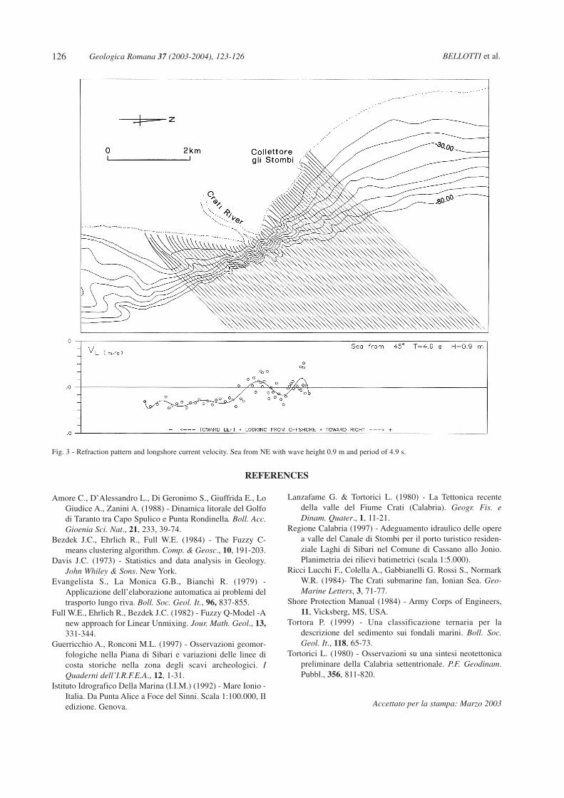
Waves from a direction of 45°, with the same periodand wave height of the 90° direction (Fig. 3), produce alongshore current from the river mouth southwards. Thecurrent velocity, after an increase near the river mouth,shows values which are a little higher than those recog-nized for the 90° direction. The versus of the longshorecurrent, as well as its velocity, is more variable along theleft delta wing; the current is directed toward NW in thearea of the Collettore gli Stombi and at the river mouth,and toward SE between them.
ACKNOWLEDGEMENTS - This research was financed bythe MIUR (Ministero dell’Istruzione, dell’Università e dellaRicerca) programs 2000 and 2001 and by IGAG (Istituto diGeologia Ambientale e Geoingegneria, C.N.R. - Roma).
Fig. 2 - Refraction pattern and longshore current velocity. Sea from East with wave height 0.9 m and period of 4.9 s.
Amore C., D’Alessandro L., Di Geronimo S., Giuffrida E., LoGiudice A., Zanini A. (1988) - Dinamica litorale del Golfodi Taranto tra Capo Spulico e Punta Rondinella. Boll. Acc.Gioenia Sci. Nat., 21, 233, 39-74.
Bezdek J.C., Ehrlich R., Full W.E. (1984) - The Fuzzy C-means clustering algorithm. Comp. & Geosc., 10, 191-203.
Davis J.C. (1973) - Statistics and data analysis in Geology.John Whiley & Sons. New York.
Evangelista S., La Monica G.B., Bianchi R. (1979) -Applicazione dell’elaborazione automatica ai problemi deltrasporto lungo riva. Boll. Soc. Geol. It., 96, 837-855.
Full W.E., Ehrlich R., Bezdek J.C. (1982) - Fuzzy Q-Model -Anew approach for Linear Unmixing. Jour. Math. Geol., 13,331-344.
Guerricchio A., Ronconi M.L. (1997) - Osservazioni geomor-fologiche nella Piana di Sibari e variazioni delle linee dicosta storiche nella zona degli scavi archeologici. IQuaderni dell’I.R.F.E.A., 12, 1-31.
Istituto Idrografico Della Marina (I.I.M.) (1992) - Mare Ionio -Italia. Da Punta Alice a Foce del Sinni. Scala 1:100.000, IIedizione. Genova.
Lanzafame G. & Tortorici L. (1980) - La Tettonica recentedella valle del Fiume Crati (Calabria). Geogr. Fis. eDinam. Quater., 1, 11-21.
Regione Calabria (1997) - Adeguamento idraulico delle operea valle del Canale di Stombi per il porto turistico residen-ziale Laghi di Sibari nel Comune di Cassano allo Jonio.Planimetria dei rilievi batimetrici (scala 1:5.000).
Ricci Lucchi F., Colella A., Gabbianelli G. Rossi S., NormarkW.R. (1984)- The Crati submarine fan, Ionian Sea. Geo-Marine Letters, 3, 71-77.
Shore Protection Manual (1984) - Army Corps of Engineers,11, Vicksberg, MS, USA.
Tortora P. (1999) - Una classificazione ternaria per ladescrizione del sedimento sui fondali marini. Boll. Soc.Geol. It., 118, 65-73.
Tortorici L. (1980) - Osservazioni su una sintesi neotettonicapreliminare della Calabria settentrionale. P.F. Geodinam.Pubbl., 356, 811-820.
Accettato per la stampa: Marzo 2003
BELLOTTI et al.126 Geologica Romana 37 (2003-2004), 123-126
REFERENCES
Fig. 3 - Refraction pattern and longshore current velocity. Sea from NE with wave height 0.9 m and period of 4.9 s.