Prehistory of Arid North Africa
28
Prehistory of Arid North Africa Essays in Honor of Fred Wendorf Edited by Angela E. Close Southern Methodist University Press Dallas
Transcript of Prehistory of Arid North Africa

Prehistory of Arid North Africa Essays in Honor of Fred Wendorf
Edited by Angela E . Close
Southern Methodist University Press Dallas
Contents
List of Contributors
Preface
1 Fred Wendorf: A Critical Assessment of His Career in and Contribution to North African Prehistory
J . DESMOND C L A R K
2 Unchanging Contrast? The Late Pleistocene Nile and Eastern Sahara
R O M U A L D S C H I L D
3 Earth, Man and Climate in the Egyptian Nile Valley During the Pleistocene
E T I E N N E P A U L I S S E N AND P I E R R E M. V E R M E E R S C H
4 Holocene Migration Rates of the Sudano-Sahelian Wetting Front, Arba'in Desert, Eastern Sahara
C. V A N C E H A Y N E S , JR.
5 Resources and Subsistence During the Early Holocene at Siwa Oasis, Northern Egypt
F E K R I A. HASSAN AND G. TIMOTHY GROSS
6 Sinai During the Paleolithic: The Early Periods JAMES L . PHILLIPS
7 The Neolithic of Central Sudan: A Reconsideration ABBAS S. A. MOHAMMED-ALI

viii Contents
8 Late Pleistocene and Early Holocene Occupations in the Upper Atbara River Valley, Sudan 137
ANTHONY E . MARKS, JORIS P E T E R S AND WIM VAN N E E R
9 Prehistoric Men and Cattle in North Africa: A Dearth of Data and a Surfeit of Models 163
A C H I L L E S G A U T I E R
10 Adaptation in Archaeology: An Example from the Libyan Sahara 189
BARBARA E . B A R I C H
11 Paleoclimatic and Cultural Conditions of Neolithic Development in the Early Holocene of Northern Niger (Air and Tenere) 211
J E A N - P I E R R E R O S E T
12 Neolithic of the Basin of the Great Eastern Erg 235 G . AUMASSIP
13 Holocene Populations of the Western and Southern Sahara: Mechtoids and Paleoclimates 259
N. P E T I T - M A I R E AND O. D U T O U R
14 Characteristics of the Final Neolithic and Metal Ages in the Region of Agadez (Niger) 287
D A N I L O G R E B E N A R T
15 Overview 317 A N G E L A E . C L O S E
Appendix
The Combined Prehistoric Expedition: The First Twenty-Five Years 325
M I C H A L K O B U S I E W I C Z
Index 345
8 Late Pleistocene and Early Holocene Occupations in the Upper Atbara River Valley, Sudan
ANTHONY E . MARKS
JORIS PETERS
WIM VAN N E E R
I N T R O D U C T I O N
During the past sixty years, many Late Pleistocene and a few Early Holocene sites have been discovered in the Nile Valley of Upper Egypt and Nubia, as far south as the Second Cataract in the Sudan (Vermeersch 1978; Vignard 1923; Wendorf 1968a; Wendorf and Schild 1976). These sites are not evenly distributed along the valley, but tend to be common in areas where major wadi systems enter the Nile Valley, such as at Ballana (Wendorf 1968b) and Wadi Kubbaniya (Wendorf et al. 1980), or where a meander of the Nile has left major expanses of Late Pleistocene silts more or less intact, as at Kom Ombo (Butzer and Hansen 1968). A comparable density of sites is also known at the Second Cataract, with its embayments and wide terrace remnants (Irwin et al. 1968; Marks 1970; Wendorf 1968a) (Figure 8.1). Yet, as one moves south from the Second Cataract, the number of Late Pleistocene sites drops markedly and rapidly. Only a handful are known from the edges of the southern end of the Cataract (Marks 1970; Shiner 1968a) and these belong technologically and typologically within those traditions that characterize the areas to the north. I t is almost as i f the Second Cataract formed as marked a barrier to the southern expansion of Late Paleolithic hunters and gatherers as it did to the later political and military aspirations of the Egyptian Old Kingdom (Adams 1977).
The paucity of Late Pleistocene sites in the area immediately south of the Second Cataract well may be explained by the radically different topography and geology. The Second Cataract marks the northern boundary of a Precambrian wilderness of weathered granites cut by metamorphic dykes, the Batn el Hajar (Belly of Stone),
137
138 Anthony Ε. Marks, Joris Peters and Wim Van Neer
where it meets the softer topography of the Nubia Sandstone region (Figure 8.1). The Nile deposited little sediment as it cut through the Batn el Hajar, and the river is often directly bordered by cliffs of Precambrian rock. Only small patches of riverside vegetation exist; the potential for life is limited at best.
However, the Batn el Hajar extends only about 125 km along the river. To the south, the open topography of the Nubia Sandstone reemerges, the river terraces broaden and run unbroken for long distances and the vegetation along the edges of the Nile and at the smaller cataracts once again becomes lush although still not extensive. Nevertheless, there is almost no sign of any Late Paleolithic occupation. Between Dal , at the southern edge of the Batn el Hajar, and Khartoum some 625 km to the south (Figure 8.1), there is not a single known aceramic site that may be attributed to the Late Pleistocene, in spite of the extensive surveys that have been undertaken between Dal and Khartoum and the presence of large exposures of Upper Pleistocene Nilotic sediments north of Khartoum (Geus 1976-79; de Heinzelin 1971; Marks et al. 1968; A . Mohammed-Ali, pers. comm.).
The absence of preceramic Late Paleolithic occupation is particularly strange because of the rather extensive distribution of early ceramic Khartoum Mesolithic-related sites between the Second Cataract and Khartoum (Arkell 1949a; Caneva 1983; Shiner 1968b), the earliest of which well may date to the very beginning of the Holocene (Khabir 1985). A t the moment, it seems as i f the central Nile Valley, south of the Batn el Hajar, saw no significant Late Pleistocene human occupation and that the Khartoum Mesolithic peoples, with their distinctive ceramics and their undistinguished stone tools, arrived as immigrants from some adjacent region.
While the region from south of the Batn el Hajar to well above Khartoum was arid during the Late Pleistocene (Wickens 1975,1982; Williams 1982), this cannot in itself account for the absence of populations along the Nile, since it was equally arid north of the Batn el Hajar where there was continuous occupation until almost the very end of the Pleistocene (Connor and Marks 1985). These climatic conditions, however, suggest that the origins of the Khartoum Mesolithic are not likely to be found in the desert or steppe areas paralleling the Nile but, rather, in some better-watered area. One such possible area is along the Atbara River which flows from Ethiopia into the Nile north of Khartoum (Figure 8.1). Recent work there has brought to light some Late Pleistocene and Early Holocene occupations that may help narrow the search for the preceramic origins of the Khartoum Mesolithic and also provide some insight into the Late Pleistocene environments and human adaptations to an arid northeastern Africa outside the Nile Valley.
H I S T O R Y O F T H E W O R K
Although detailed examination of the upper Atbara River Valley has been carried out only recently (Marks et al. 1982a, 1982b), it is more than thirty years since Arkell (1949b) noted Lower Paleolithic artifacts along the river near the present town of Khashm el Girba (Figure 8.2). In 1966, during a month-long survey of the river valley and the adjacent steppe near the same town, a project under the direction of Dr. J. Shiner located a large number of prehistoric sites which mainly seemed to fall into one of two periods: Lower Paleolithic or early ceramic (Shiner 1971). Unfortunately,

Occupations in the Upper Atbara River Valley, Sudan 139
26 30 2U 38
Figure 8.1 Map of northeastern Africa, showing places mentioned in the text.
although some surface collections were made and some small test-excavations carried out, no detailed reports have appeared, particularly on the preceramic materials, and little concerning them has passed into the literature.

140 Anthony Ε. Marks, Joris Peters and Wim Van Neer
In 1981, the Joint University of Khartoum/Southern Methodist University Archaeological Project was initiated, of which a major aim was to elucidate the culture history of both the eastern and western fringes of the Butana grasslands—that huge area east of the central Nile Valley and west of the Eritrean Hills in Ethiopia (Figure 8.1). Because of Shiner's pioneering survey, the area around Khashm el Girba was chosen as part of the eastern fringe to be studied.
Among the many sites noted by Shiner were a few clustered just northeast of Khashm el Girba that appeared to be preceramic and, perhaps, Late Paleolithic. Although no radiometric dates were available, the surface artifacts included well-made tools usually associated with the end of the Paleolithic—backed blades, geometric microliths, endscrapers and so forth—made on good quality chert or, more rarely, on agate (Shiner 1971:308-312). Most of these sites were described as being in advanced stages of deflation in 1966, so it was not certain that all or some would be still even partially intact in 1981. In fact, because of the rough nature of the original survey notes and the intervening years of deflation and erosion, it cannot be established whether or not the sites located in 1981 were those originally noted by Shiner. In the most general sense, the sites he found and those we found are very similar. However, they do not seem to be identical, and the ever-evolving landscape around Khashm el Girba brings new sites to the surface almost every year before destroying them by the rather rapid processes of deflation and sheetwash.
T H E S E T T I N G
Most of the Late Paleolithic sites reported by Shiner and all of those located in 1981 are clustered near a bend of the Atbara River, 8 km north of the new dam above Khashm el Girba (Figure 8.2). A few kilometers north of the dam, which is built in a narrow, water-cut gorge, the river makes a 90° turn to the east and then returns to its generally northerly direction 7 km later. This portion of the river still shows an earlier meander channel, slightly north of but parallel to the present, active river-channel (Figure 8.2). North of the old meander, earlier Atbara silts and gravel-bars form a rectangular block, 12 k m 2 in area and inset into probable Middle Pleistocene deposits which rise some 25 m above the modern floodplain. The approximate center of this inset of fluvial deposits, which is about 2 km west of the present, northward-flowing Atbara, reaches a maximum elevation of just over 12 m above the floodplain. A t this (12-m) elevation, the surface has a minor basin-like topography, with a small depression, perhaps no more than a square kilometer in area and no more than 4 m below a low ridge that slightly accentuates the depression on the riverward side. The depression is less marked on the inland side, being only about 3 m below an expanse of flat silts and gravel-bars that extend west and north to the eroding slopes of the higher Middle Pleistocene terraces (Figure 8.2).
With the exception of a few trees along the modern floodplain, the riverside slope of the alluvial sediments is devoid of significant vegetation. There is a scatter of small thorn-trees in the one moderately developed drainage but, for the most part, the surface of the ground is bare and featureless. In the depression, however, there is fairly dense vegetation, mainly thorn-trees but also sparse remnants of annuals missed by the herds of goats which graze the area. Thus, even today the depression receives and holds more moisture than the surrounding sediments, although there are small clumps of thorn-trees scattered across the area between the depression and the Middle Pleistocene sediments to the north and west.

Occupations in the Upper Atbara River Valley, Sudan 141
Figure 8.2 Map of the Khashm el Girba area, showing the depression.
T H E S I T E S
Most of the preceramic sites are located near the low ridge which borders the depression on the east. Additional sites occur farther to the east on the gentle slope leading down to the modern floodplain (Figure 8.3). No sites were located on the western side of the depression or within it.
The sites near the depression were of two kinds: those still partly in situ with dense surface concentrations of chert artifacts and those fully on the surface with low densities of mainly quartz artifacts. Although all sites were either test-excavated or systematically surface collected, or both, it was the former group of sites that were of most

Meters
Figure 8.3 Map of the eastern part of the depression with the spatial relationship between sites, gravel-bars and the Atbara River. The upper section shows the elevational changes along the transect

Occupations in the Upper Atbara River Valley, Sudan 143
interest. Not only can they be tied geologically to the alluvial sediments but they also contained a good range of faunal materials, significant numbers of artifacts and, occasionally, datable organic materials. This paper wi l l deal only with this group of sites; the second group wil l be published elsewhere by Dr. Y. El Amin.
A l l but one of the in situ sites are clustered on or near the low ridge on the eastern side of the depression. They occur on both sides of the ridge: K G 15 and K G 16 are on its western slope, while KG73 and KG74 are on the flat surface of the sediments just at the eastern edge of the slight rise which forms the crest. The final site, KG68, lies about 1 km east-southeast of the ridge and has been exposed by the recent advance of a shallow erosional system (Figure 8.3). This system has uncovered several sites but only KG68 was sufficiently large and in situ to warrant more than a systematic surface collection. Also, it is the only site in this portion of the sediments that seems to relate to the cluster of in situ sites adjacent to the depression. The other sites were sometimes rich with artifacts, but had very few retouched tools of any kind and the raw material was almost exclusively quartz.
The sites chosen for detailed study exhibited considerable variability in size and internal structure. The largest, KG15 , had been exposed by a short, but marked, erosional channel which divided it into two distinct areas. The northern area provided in situ material and charcoal samples to a depth of 20 cm. Artifact densities were not high, so an adjacent area of 50 m 2 was collected to increase the sample. This was called K G 16, but, in reality, is an extension of K G 15. I t has been kept separate here because its tool assemblage shows some significant differences from the K G 15 sample. The differences are clearly seen in the test-excavations of the two areas and so are not a result of artifact-loss due to slopewash. On the southern side of the erosional cut, a large area of surface artifacts was brought to light by minor secondary erosion. A large excavation area was placed just above this erosional zone which provided a good sample of in situ artifacts, as well as some faunal remains. However, none of the excavations revealed dense concentrations of artifacts, although clusters did occur. The initial excavations in 1981 were limited to 16 m 2 on the northern side and 10 m 2 on the south. The southern excavations were greatly expanded in 1982 but this paper will deal only with the sample recovered from the southern area in 1981. The larger artifact sample wil l be published by Dr. Y. El Amin in the future. The overall size of K G 15 could not be determined accurately, since so much of it may have been completely buried. A rough estimate, based on surface indications, would be at least 3100 m 2 .
The second largest site near the depression is KG73 which has surface artifacts over an area of some 1700 m 2 . Although there was no evidence for water-erosion, the artifacts had been exposed by deflation and by a slight disturbance of the surface in recent times. The surface concentration was dense across the entire site, and subsequent excavations indicated that the cultural deposits were less than 15 cm deep. Rare faunal remains were found on the surface and even fewer in situ. The site was mixed, since a scatter of crude ceramics, metals and fine china occurred with the lithic artifacts on the surface. While the metal and china could be excluded, the very crude ceramics were a problem since they might have been the earliest ceramics in the Sudan. After the discovery of a complete sneaker at a depth of 10 cm, questioning of the local inhabitants brought forth the family who had camped on the site for a few years around 1940. The ceramics were theirs, all of them. The crude pieces were not the earliest locally made ceramics but among the most recent, and the surface impressions were truly fabric impressed—with burlap and sheet cotton! In any case, the intrusive elements could be recognized easily and the sample described here can be considered a single component.
144 Anthony Ε. Marks, Joris Peters and Wim Van Neer
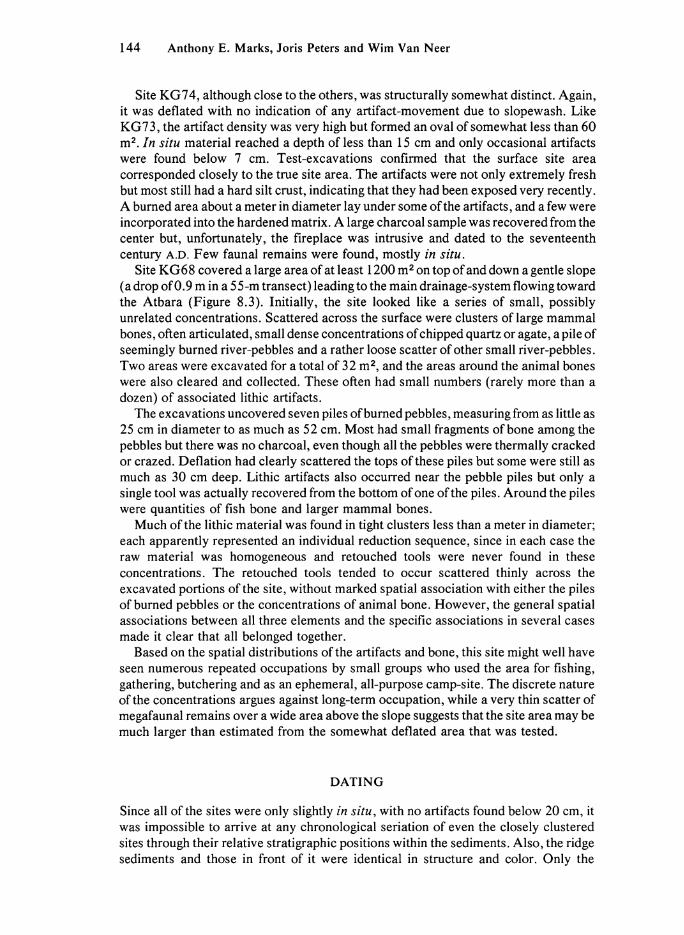
Site KG74, although close to the others, was structurally somewhat distinct. Again, it was deflated with no indication of any artifact-movement due to slopewash. Like KG73, the artifact density was very high but formed an oval of somewhat less than 60 m 2 . In situ material reached a depth of less than 15 cm and only occasional artifacts were found below 7 cm. Test-excavations confirmed that the surface site area corresponded closely to the true site area. The artifacts were not only extremely fresh but most still had a hard silt crust, indicating that they had been exposed very recently. A burned area about a meter in diameter lay under some of the artifacts, and a few were incorporated into the hardened matrix. A large charcoal sample was recovered from the center but, unfortunately, the fireplace was intrusive and dated to the seventeenth century A.D. Few faunal remains were found, mostly in situ.
Site KG68 covered a large area of at least 1200 m 2 on top of and down a gentle slope (a drop of 0.9 m in a 55-m transect) leading to the main drainage-system flowing toward the Atbara (Figure 8.3). Initially, the site looked like a series of small, possibly unrelated concentrations. Scattered across the surface were clusters of large mammal bones, often articulated, small dense concentrations of chipped quartz or agate, a pile of seemingly burned river-pebbles and a rather loose scatter of other small river-pebbles. Two areas were excavated for a total of 32 m 2 , and the areas around the animal bones were also cleared and collected. These often had small numbers (rarely more than a dozen) of associated lithic artifacts.
The excavations uncovered seven piles of burned pebbles, measuring from as little as 25 cm in diameter to as much as 52 cm. Most had small fragments of bone among the pebbles but there was no charcoal, even though all the pebbles were thermally cracked or crazed. Deflation had clearly scattered the tops of these piles but some were still as much as 30 cm deep. Lithic artifacts also occurred near the pebble piles but only a single tool was actually recovered from the bottom of one of the piles. Around the piles were quantities of fish bone and larger mammal bones.
Much of the lithic material was found in tight clusters less than a meter in diameter; each apparently represented an individual reduction sequence, since in each case the raw material was homogeneous and retouched tools were never found in these concentrations. The retouched tools tended to occur scattered thinly across the excavated portions of the site, without marked spatial association with either the piles of burned pebbles or the concentrations of animal bone. However, the general spatial associations between all three elements and the specific associations in several cases made it clear that all belonged together.
Based on the spatial distributions of the artifacts and bone, this site might well have seen numerous repeated occupations by small groups who used the area for fishing, gathering, butchering and as an ephemeral, all-purpose camp-site. The discrete nature of the concentrations argues against long-term occupation, while a very thin scatter of megafaunal remains over a wide area above the slope suggests that the site area may be much larger than estimated from the somewhat deflated area that was tested.
D A T I N G
Since all of the sites were only slightly in situ, with no artifacts found below 20 cm, it was impossible to arrive at any chronological sedation of even the closely clustered sites through their relative stratigraphic positions within the sediments. Also, the ridge sediments and those in front of it were identical in structure and color. Only the

Occupations in the Upper Atbara River Valley, Sudan 145
presence of numerous root-casts and a somewhat greater cementation at K G 15, on the depression side of the ridge, differentiated it from the other deposits.
In spite of the stratigraphic limitations, a sample for radiocarbon dating was acquired from site K G 15, producing a date of 10,230 B.P. ± 270 years ( S M U . l 149). From their stratigraphic position, KG73 and KG74 cannot be of a very different age, although technologically and typologically they should be somewhat older.
A shell sample from KG68 permitted a single date of 7700 B.P. ± 90 years (SMU. l607) , which is consistent with the site's stratigraphic position within the inset (8.2 m above the floodplain). I t seems likely that the Atbara began to incise its bed about the beginning of the Holocene and continued to down-cut, with short episodes of stability, until the present day. In fact, an early ceramic site, the Pre-Saroba K G 14 (Fattovich et al. 1984), is situated at 3.75 m above the floodplain and has an appropriately younger radiocarbon date of 6215 B.P. ± 75 years ( S M U . l 139). While additional dates would be desirable, it is still reasonable to believe that the occupations near the depression were Terminal Pleistocene, while KG68 was visited during the Early Holocene.
T H E A S S E M B L A G E S
While a separate, detailed description of the technology and typology of each assemblage might well be justified, since assemblages of this type have never been described before, those from the clustered sites of KG74, KG73, K G 15 and K G 16 are sufficiently similar in all ways that they may be treated together. They are not identical but clearly belong to the same industry. The KG68 assemblage, however, is distinct in a number of ways from the others and will be treated separately. Nevertheless, there are enough points of congruence between it and the other assemblages to postulate that it represents a more recent phase of the same industry.
RAW M A T E R I A L UTILIZATION
The assemblages, as sampled, consisted mainly of chipped stone, although four pieces of ground handstones were found in situ at K G 15 and a fragment of a grinding-stone was recovered from KG68. A l l of these were made on rough volcanic rock commonly available in the gravels of the river. The chipped stone at all sites has the same range, although some very significant differences exist between the clustered sites and KG68 (Table 8.2). Virtually all the stone at all of the sites came as pebbles or small cobbles from the nearby Atbara gravel-bars. A l l of the gravel-bars examined contained a wide range of raw materials, including agate, chert, quartzite, quartz, greenstone and volcanic rock, but the gravel-bars above 8 m are dominated by cherts, while those below 8 m are largely made up of quartz pebbles. Agate and greenstone are never common. The specific gravel-bar source of raw material for any one site is unknown, since there are many remnants in the sediments which, like the sites, are now being exposed by deflation. I t seems clear, however, that the acquisition of raw material was not a problem and that enough of any kind of raw material present in the gravels could be collected with little effort. Thus, differences in raw material utilization would reflect cultural decisions.

146 Anthony Ε. Marks, Joris Peters and Wim Van Neer
T A B L E 8.1
Tool and Debitage Raw Material Utilization as Percentages
KG74 KG73 KG15 KG16 KG68
Tools Chert 88.9 89.0 79.2 71.7 16.8 Quartz 0.5 0.9 1.9 4.4 1.0 Agate 8.7 10.1 14.2 23.0 81.7 Greenstone 1.9 - - 0.9 0.5 Other - - 4.7 - -Sample size 416 109 106 113 197
Debitage Chert 88.3 91.2 90.3 60.9 9.5 Quartz 1.1 5.3 0.9 6.5 38.3 Agate 9.4 3.2 8.7 31.7 45.1 Greenstone - 0.4 - 0.2 -Other 1.1 - 0.4 0.7 6.6 Sample size 995 2434 793 1178 1309
Chert was the favored raw material at sites KG74 and KG73 and raw material selection for tool-production directly reflected the overall proportions of raw materials brought to the sites (Table 8.1). A slight shift can be seen at K G 15, even more strongly expressed at K G 16, where there is a proportionately greater use of agate for tool-production than in the selection of raw material brought to the site. However, chert remains the dominant raw material. This shift can be correlated with two factors: chert pebbles tend to be significantly larger than those of agate and its flaking qualities permit greater control in blade-production than is the case for the more brittle agate. On the other hand, both raw materials are suitable for the production of flake-tools. I t is not surprising, therefore, that the percentage of flake-tools increases from sites KG73 and KG74 toKG15 and KG16.
This shift to increasing utilization of agate in tool-production is markedly accentuated at KG68, but there is also a major increase in the amount of agate brought to the site (Table 8.1). In addition, for the first time, quartz is found in significant proportions in the debitage. This is hard to explain, since quartz flakes were almost never chosen for retouch. Its presence is certainly linked with its increased availability in the gravel-bars near KG68, as compared with those near the clustered sites, but the paucity of retouched quartz tools suggests either that it was not highly valued or that quartz flakes were used without formal retouch. In spite of the drop in the frequency of chert in both the debitage and overall tool-production, there was a positive selection of it (Table 8.1).
Part of any explanation regarding shifting raw material preferences must also be seen in light of changes in basic core-reduction strategies which can be traced from KG74 to KG68. Again, KG68 stands apart from the others but does so by an accentuation of already existing trends.
T E C H N O L O G Y
The assemblages from KG74, KG73, KG15 and KG16 were dominated by a simple blade-producing strategy. Rather large chert pebbles were selected, one end was struck off more or less perpendicular to the long axis of the pebble and blades were then struck off around the face. There appears to have been no special core-preparation, no

Occupations in the Upper Atbara River Valley, Sudan 147
T A B L E 8.2
Retouched Tool Assemblages
KG74 KG73 KG15 KG16 KG68
No. % No. % No. % No. % No. %
Simple endscrapers 11 2.6 7 6.5 4 3.9 30 26.5 3 1.5 Thumbnail scrapers 13 3.1 2 1.8 6 5.8 2 1.8 0 -Denticulate endscrapers 6 1.5 2 1.8 1 1.0 1 0.9 1 0.5 Microdejete scrapers 12 2.9 2 1.8 2 1.9 2 1.8 0 -Sidescrapers 2 0.4 0 - 1 1.0 0 - 0 -Perforators 3 0.7 0 - 1 1.0 0 - 2 1.0 Burins 2 0.5 0 - 0 - 0 - 2 1.0 Scaled pieces 0 - 3 2.8 3 2.9 6 5.3 82 41.6 Denticulates 7 1.7 10 9.1 5 4.9 4 3.5 3 1.5 Notches 37 8.9 3 2.8 7 6.8 8 7.1 6 3.0 Retouched pieces 58 14.0 21 19.3 11 10.7 14 12.4 22 11.2 Truncated flakes 0 - 0 - 0 - 2 1.8 3 1.5 Truncated blades 51 12.3 10 9.2 10 9.7 0 - 1 0.5 Trapezes 5 1.2 1 0.9 2 1.9 0 - 0 -Backed trapezes 38 9.2 7 6.4 9 8.7 8 7.1 0 -Triangle 0 - 1 0.9 0 - 0 - 0 -Lunates 7 1.7 3 2.8 0 - 5 4.4 1 0.5 "Orange wedges" 12 2.9 12 11.0 9 8.7 7 6.2 18 9.2 Backed and truncated blades 80 19.2 14 12.8 17 16.5 9 8.0 0 -Backed and truncated flakes 0 - 0 - 0 - 0 - 3 1.5 Backed blades 58 14.0 11 10.1 13 12.6 10 8.8 0 -Backed flakes 1 0.2 0 - 1 1.0 2 1.8 42 21.3 Denticulate backed flakes 0 - 0 - 0 - 2 1.8 3 1.5 Backed blades with modified base 4 0.9 0 - 0 - 1 0.9 0 -Double-backed blades 4 0.9 0 - 1 1.0 0 - 0 -KG74 point 5 1.2 0 - 0 - 0 - 0 -Varia 0 - 0 - 0 - 0 - 5 2.5
Total 416 109 103 113 197
production of lames a crete, no faceting of the platforms. The cores tend to have broad, slightly convex flaking-surfaces (Figure 8.4: b), although the flaking-surface may go much of the way around the pebble (Figure 8.4: d, e). A few exhibit opposed-platform reduction but this was mainly a shifting of the striking-platform to the opposite end of the pebble when the original flaking-surface could no longer be used because of either a crushed platform or hinge-fracturing (Figure 8.4: f). A few core-tablets were found, but this rejuvenation technique was apparently rare, perhaps because of the already rather small size of the available pebbles. Most blade cores were of chert but agate was also used occasionally.
While blade-production was the dominant technique, two other reduction strategies were used: simple flake-production from roughly faceted or unfaceted cores and, more rarely, bipolar reduction. The latter technique is absent at KG74, represents 19% of the cores at KG73 (only four examples!) and has about equal percentages at K G 15 and K G 16 ( ± 2 5 % ) . A t KG68, bipolar reduction accounts for 49%, while blade cores are virtually absent. This shift in reduction strategies is reflected in the shift in raw material selection, since a bipolar technique can produce flakes much more efficiently from agate than from chert.

148 Anthony Ε. Marks, Joris Peters and Wim Van Neer
Figure 8.4 Cores and Tools from KG74. a, inverse denticulate; b, single-platform core with wide flaking-surface; c, retouched flake; d, e, single-platform cores with blade-removal around almost the whole circumference; f, opposed-platform core.
Finally, the relative importance of blade-production as a means of producing tool-blanks also shows a shift. Blade-tools dominate the assemblages from KG74 and KG73 (65.6% and 61.5%, respectively). A t KG15 and KG16 they range between 56.7% and 46.9%, while they fall drastically to only 3.6% at KG68. This is consistent with the other technological changes; the shift to more brittle raw material for flaking, the increased use of bipolar reduction to produce both blanks and finished tools (scaled pieces), and the apparent use of unretouched quartz flakes as tools.
While it might be expected that these strong technological changes would be reflected in important typological changes, the latter tend to be fairly limited and, on the whole, predictable.
T Y P O L O G Y
As with most Late Paleolithic assemblages in the northern Nile Valley, these assemblages from near Khashm el Girba contain a good range of backed tools, including geometries, backed blades and backed and truncated blades (Table 8.2). However, unlike the tool-assemblages in the Nile Valley, the backed elements here are

Occupations in the Upper Atbara River Valley, Sudan 149
made exclusively on blades sensu stricto; not a single backed blade-tool from any of these assemblages falls within the metric parameters of a bladelet-tool( <8 mm wide). In fact, not only are they on blades but they also tend to be exceptionally large. Perhaps as a balance to this, the well-represented scrapers tend to be extremely small—much smaller than in any other assemblage in northeastern Africa. Together, these tendencies give a very curious aspect to the assemblages. The tool-assemblage from KG68 is again somewhat different but it , too, has aspects unknown elsewhere in the Sudan and Egypt.
The tool-assemblages from the clustered sites KG74 , KG73, KG15 and KG16 wil l be described first, and then those from KG68.
The Clustered Sites: K G 7 4 , K G 7 3 , K G 1 5 and K G 1 6
As noted above, endscrapers tend to be very small, rarely exceeding 40 mm in length. The majority in each assemblage are on either small flakes (Figure 8.6:1) or primary flakes; only a very few are on blades. They tend to be well made, with symmetrically rounded scraping-edges formed by semi-steep retouch. A small number have regular, finely serrated scraping-edges but the two outstanding types are the thumbnail scrapers and those that must be considered microdejete. The former are similar to normal endscrapers but tend to be smaller, rarely exceeding 30 mm in length, and always have a finely rounded scraping-edge (Figure 8.5: h, k, 1; Figure 8.6: o); a single example is circular (Figure 8.6: m). The microdejete scrapers are different from any scraper so far reported from northeastern Africa. They tend to be extremely small (15-25 mm in length) and take one of two forms: they may be fairly flat with a slightly convex transverse scraping-edge and two shorter, lateral scraping-edges (Figure 8.5: f, g) or, more commonly, they are relatively thick and tend to have strong semi-steep to steep retouch on three edges. The scrapers are, thus, triangular (Figure 8.5: j ) or somewhat irregularly ovoid (Figure 8.5: i ) , or, rarely, may be rectangular and resemble minute double-sidescrapers (Figure 8.6: n), depending on the shape of the individual scraping-edges. In all cases, the bulb of percussion has been removed by retouch, so that the entire circumference is retouched. Nevertheless, there are no circular examples.
The sidescrapers are essentially lateral endscrapers but the arch of the scraping-edge is not well developed and its length exceeds the width of the blank.
Perforators and burins are very rare and poorly made. Apart from a single burin on truncation, the other examples may result as much from the typologists' sorting as from any intentions of the inhabitants of the sites.
While scaled pieces are rare, they are present in three of the four sites; only KG74 lacks them, as it also lacked bipolar cores. Unlike most other tools, scaled pieces are normally made on agate, although one each from KG73 and K G 16 is made on quartz. Scaled pieces are very common at later, ceramic-bearing sites, but these were recovered in situ and there can be no question as to their association.
Simpler tools, such as retouched pieces, denticulates and notched pieces are common at all sites. The denticulates are mainly simple lateral pieces (Figure 8.4: a; Figure 8.6: q), although occasionally more than one edge was retouched (Figure 8.5: q). Continuously retouched pieces tend to have good retouch (Figure 8.4: c; Figure 8.6: a), and merely lack the morphology or strength of retouch that would place them in some other tool-type (Figure 8.5: r). As with the scrapers, the majority of all these forms are made on flakes rather than blades.

150 Anthony Ε. Marks, Joris Peters and Wim Van Neer
s t U V w
Figure 8.5 Tools from KG74. a, b, double-backed blades; c-e, ρ, s, t, backed trapezes; f, g, i, j , microdejete scrapers; h, k, 1, thumbnail scrapers; m, u, v, KG74 points; η, ο, lunates; q, denticulated flake; r, bilaterally retouched piece; w, "orange wedge."
The remaining tools, the backed or truncated forms, are almost all produced on blades. Only at K G 16 are there two truncated flakes, and backed flakes are almost equally rare (Table 8.3).
The numerically most important backed tool-groups are those with truncations and backing, those with only truncations and those with only backing. The last is made up almost exclusively of fragments that may be parts of more complex retouched tools. However, occasional simple backed blades were found (Figure 8.6: j ) . The tools with truncations alone also tend to be fragmentary (Figure 8.6: f) and may also be portions of other tools.
Occupations in the Upper Atbara River Valley, Sudan 151
q r s t
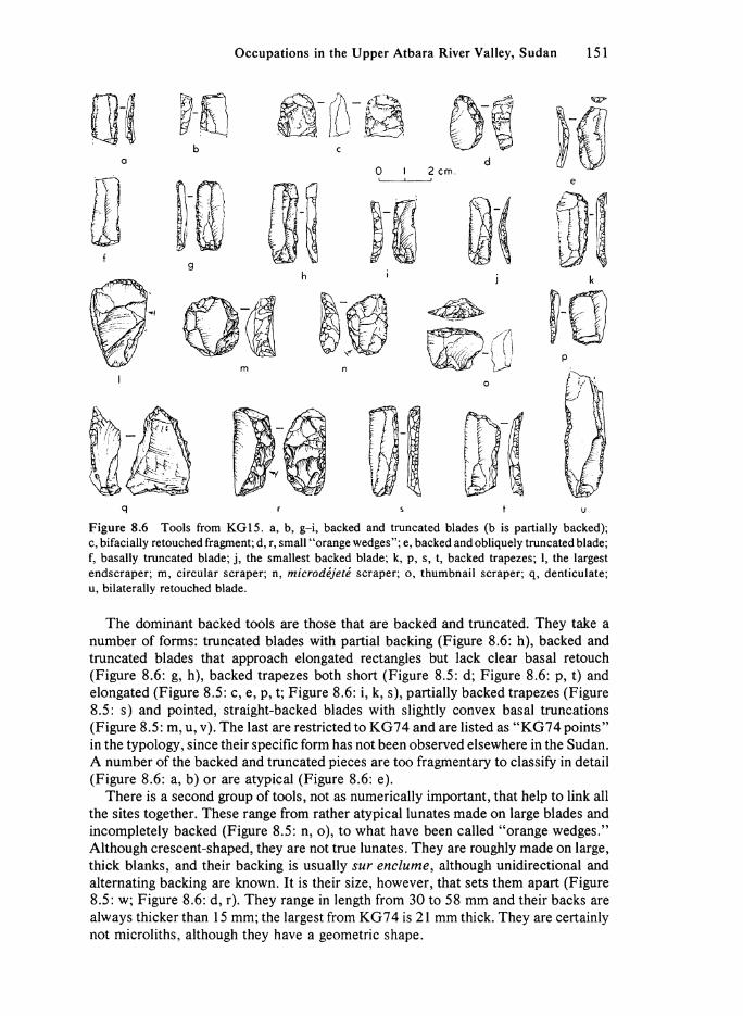
Figure 8.6 Tools from K G 15. a, b, g-i, backed and truncated blades (b is partially backed); c, bifacially retouched fragment; d, r, small "orange wedges"; e, backed and obliquely truncated blade; f, basally truncated blade; j , the smallest backed blade; k, p, s, t, backed trapezes; 1, the largest endscraper; m, circular scraper; n, microdejete scraper; o, thumbnail scraper; q, denticulate; u, bilaterally retouched blade.
The dominant backed tools are those that are backed and truncated. They take a number of forms: truncated blades with partial backing (Figure 8.6: h), backed and truncated blades that approach elongated rectangles but lack clear basal retouch (Figure 8.6: g, h), backed trapezes both short (Figure 8.5: d; Figure 8.6: p, t) and elongated (Figure 8.5: c, e, p, t; Figure 8.6: i , k, s), partially backed trapezes (Figure 8.5: s) and pointed, straight-backed blades with slightly convex basal truncations (Figure 8.5: m, u, v). The last are restricted to KG74 and are listed as " K G 7 4 points" in the typology, since their specific form has not been observed elsewhere in the Sudan. A number of the backed and truncated pieces are too fragmentary to classify in detail (Figure 8.6: a, b) or are atypical (Figure 8.6: e).
There is a second group of tools, not as numerically important, that help to link all the sites together. These range from rather atypical lunates made on large blades and incompletely backed (Figure 8.5: n, o), to what have been called "orange wedges." Although crescent-shaped, they are not true lunates. They are roughly made on large, thick blanks, and their backing is usually sur enclume, although unidirectional and alternating backing are known. I t is their size, however, that sets them apart (Figure 8.5: w; Figure 8.6: d, r). They range in length from 30 to 58 mm and their backs are always thicker than 15 mm; the largest from KG74 is 21 mm thick. They are certainly not microliths, although they have a geometric shape.

152 Anthony Ε. Marks, Joris Peters and Wim Van Neer
T A B L E 8.3
Absolute Frequencies of Non-Mammalian Remains
Animal Group/Species
Marine gastropods Cypraea moneta
Freshwater Molluscs Pi la sp. Spathopsis sp. Mute la dubia Etheria elliptica Large bivalves
Landsnails Limicolaria cailliaudi
Fish Polypterus (Polypterus sp.) Elephant-snout fishes (Mormyridae) Minnows (Cyprinidae) Catfishes: Synodontis sp.
Bagus sp. Others
Nile perch {hates niloticus) Tilapia (Tilapia sp.) Percomorphi indet.
Reptiles
Bell's eastern hinged tortoise (Kinixys belliana) Hinged tortoise (Kinixys sp.) Terrapin (Pelusios sp.) Cyclanorbine turtle (Cyclanorbis elegansl) Monitor (Varanus sp.) Snake (Serpentes indet.)
Birds Bird or prey (Accipitridae sp.) Ostrich (Struthio camelusf
K G 15 K G 16 KG73 KG74 KG68
RR
RR(+) (+) RR RR
F (+) (+) R(+) RR RR (+) RR RR
RR RR(+) R
9 1
29 2 3 4
1 364(76) 52(2)
36 6
4 1 1 1 1
1
1 5(7) Note: The absolute frequencies are based on specimen counts. Numbers in brackets indicate surface
material, the rest was in situ. The symbols used to describe the molluscan assemblage are as follows: +, present; RR, <5 specimens; R, 6-20 specimens; F , 21-100 specimens. ^Ostrich is represented only by fragments of eggshell.
A small number of the backed trapezes show traces of light sickle sheen (Figure 8.5: e). The number of these recognized is probably too low, since tools on agate are already so shiny that it is usually impossible to recognize sickle sheen. Thus, no absolute frequencies are given for pieces with sheen; they are present and possibly numerous.
There are also a few backed blades with inversely or obversely modified bases, a few fragments of double-backed blades (Figure 8.5: a), one of which is pointed (Figure 8.5: b), and two denticulate-backed flakes from K G 16.
Although the assemblages are very similar in most ways, there are some trends that seem important. The appearance of scaled pieces at KG73 and their greater presence at K G 15 and K G 16 might point toward the KG68 assemblage. The presence of truncated and backed flakes at K G 16 forms another typological link with KG68.
Occupations in the Upper Atbara River Valley, Sudan 153
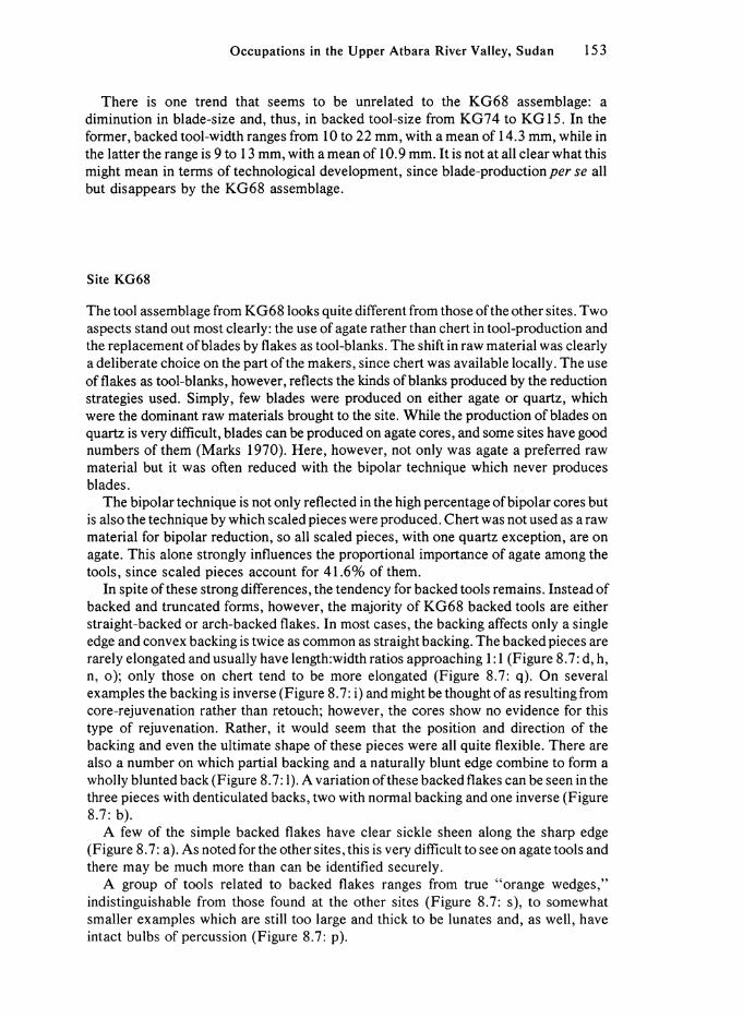
There is one trend that seems to be unrelated to the KG68 assemblage: a diminution in blade-size and, thus, in backed tool-size from KG74 to KG15. In the former, backed tool-width ranges from 10 to 22 mm, with a mean of 14.3 mm, while in the latter the range is 9 to 13 mm, with a mean of 10.9 mm. I t is not at all clear what this might mean in terms of technological development, since blade-production per se all but disappears by the KG68 assemblage.
Site KG68
The tool assemblage from KG68 looks quite different from those of the other sites. Two aspects stand out most clearly: the use of agate rather than chert in tool-production and the replacement of blades by flakes as tool-blanks. The shift in raw material was clearly a deliberate choice on the part of the makers, since chert was available locally. The use of flakes as tool-blanks, however, reflects the kinds of blanks produced by the reduction strategies used. Simply, few blades were produced on either agate or quartz, which were the dominant raw materials brought to the site. While the production of blades on quartz is very difficult, blades can be produced on agate cores, and some sites have good numbers of them (Marks 1970). Here, however, not only was agate a preferred raw material but it was often reduced with the bipolar technique which never produces blades.
The bipolar technique is not only reflected in the high percentage of bipolar cores but is also the technique by which scaled pieces were produced. Chert was not used as a raw material for bipolar reduction, so all scaled pieces, with one quartz exception, are on agate. This alone strongly influences the proportional importance of agate among the tools, since scaled pieces account for 41.6% of them.
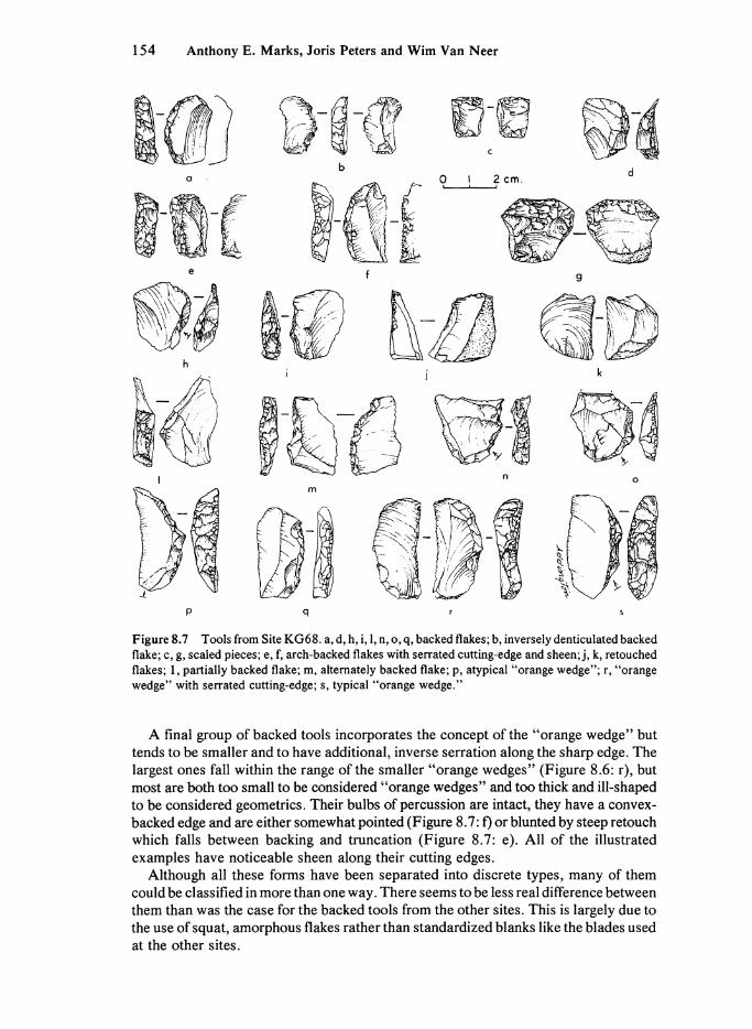
In spite of these strong differences, the tendency for backed tools remains. Instead of backed and truncated forms, however, the majority of KG68 backed tools are either straight-backed or arch-backed flakes. In most cases, the backing affects only a single edge and convex backing is twice as common as straight backing. The backed pieces are rarely elongated and usually have length:width ratios approaching 1:1 (Figure 8.7: d, h, n, o); only those on chert tend to be more elongated (Figure 8.7: q). On several examples the backing is inverse (Figure 8.7: i) and might be thought of as resulting from core-rejuvenation rather than retouch; however, the cores show no evidence for this type of rejuvenation. Rather, it would seem that the position and direction of the backing and even the ultimate shape of these pieces were all quite flexible. There are also a number on which partial backing and a naturally blunt edge combine to form a wholly blunted back (Figure 8.7:1). A variation of these backed flakes can be seen in the three pieces with denticulated backs, two with normal backing and one inverse (Figure 8.7: b).
A few of the simple backed flakes have clear sickle sheen along the sharp edge (Figure 8.7: a). As noted for the other sites, this is very difficult to see on agate tools and there may be much more than can be identified securely.
A group of tools related to backed flakes ranges from true "orange wedges," indistinguishable from those found at the other sites (Figure 8.7: s), to somewhat smaller examples which are still too large and thick to be lunates and, as well, have intact bulbs of percussion (Figure 8.7: p).
154 Anthony Ε. Marks, Joris Peters and Wim Van Neer
P q r s
Figure 8.7 Tools from Site KG68. a, d, h, i, 1, n, o, q, backed flakes; b, inversely denticulated backed flake; c, g, scaled pieces; e, f, arch-backed flakes with serrated cutting-edge and sheen; j , k, retouched flakes; 1, partially backed flake; m, alternately backed flake; p, atypical "orange wedge"; r, "orange wedge" with serrated cutting-edge; s, typical "orange wedge."
A final group of backed tools incorporates the concept of the "orange wedge" but tends to be smaller and to have additional, inverse serration along the sharp edge. The largest ones fall within the range of the smaller "orange wedges" (Figure 8.6: r) , but most are both too small to be considered "orange wedges" and too thick and ill-shaped to be considered geometries. Their bulbs of percussion are intact, they have a convex-backed edge and are either somewhat pointed (Figure 8.7: f) or blunted by steep retouch which falls between backing and truncation (Figure 8.7: e). A l l of the illustrated examples have noticeable sheen along their cutting edges.
Although all these forms have been separated into discrete types, many of them could be classified in more than one way. There seems to be less real difference between them than was the case for the backed tools from the other sites. This is largely due to the use of squat, amorphous flakes rather than standardized blanks like the blades used at the other sites.

Occupations in the Upper Atbara River Valley, Sudan 155
Of the remaining tools, simple retouched pieces are the most common, including both inversely (Figure 8.7: k) and obversely retouched pieces (Figure 8.7: j ) ; of the 22 recorded, only two are on blades. There are a few poorly made endscrapers and one nicely retouched denticulate endscraper. The burins are poor but one on truncation is certainly intentional. The simple truncations are atypical but one is on a chert blade. There is a small pebble chopper and a few varia, which include some fragmentary flakes with alternate backing (Figure 8.7: m), as well as two notched and retouched flakes.
F A Ü N A L R E M A I N S
The faunal remains, like the lithic artifacts, come from two sources: surface collections and the dry-screening of excavated sediments through 4-mm mesh. Because of the limited size of the excavations and the low faunal yield of most sites, surface material was collected to enhance sample sizes; all bone collected from the surface was taken from fully within the surface scatter of the lithic material.
The faunal material from the clustered sites, KG74, KG73, KG15 and KG16, was rather heavily degraded and fragmented, and moderately fossilized. This condition applies to both the surface and in situ material, suggesting that the non-mammalian groups of bones from these sites may be under-represented in the available collections; however, this cannot be estimated quantitatively.
The faunal material from KG68 was in considerably better condition, being less degraded, fragmented and fossilized. In light of the very large sample of small fish bones, it is likely that there was no significant loss of smaller bones at this site to weathering and other factors.
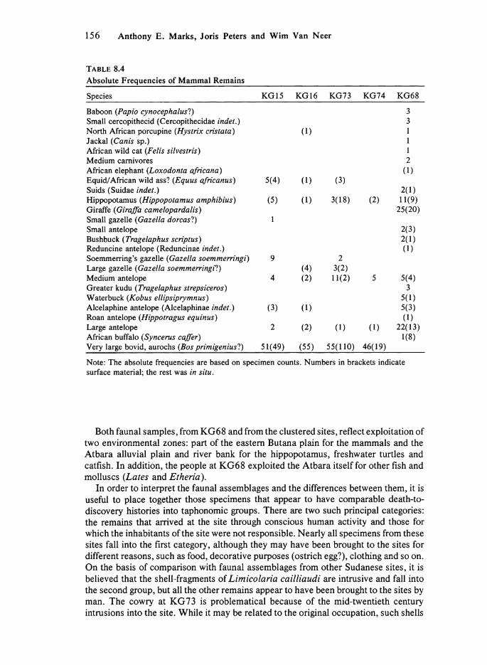
As the lithic assemblages from the clustered sites go together, so do the faunal samples from them. These samples are dominated by mammals such as hippopotamus (Hippopotamus amphibius), Soemmerring's gazelle (Gazella soemmerringi). and aurochs (Bos primigenius). There were also some large antelopes, equids, a few Synodontis catfish remains and single elements of a bird and a snake (Tables 8.3 and 8.4).
The faunal material from KG68 is quite different, consisting mainly of fishes but also including good numbers of large mammals (Tables 8.3 and 8.4). Compared to the clustered sites, the fish remains are both numerous and varied with clariid catfish (Synodontis and Bagus), Nile perch (Lates niloticus), tilapia (Tilapia sp.) and minnows (Cyprinidae) in some numbers and with rare examples of polypterus (Polypterus sp.) and elephant-snout fishes (Mormyridae). Mammalian remains are dominated by giraffe (Giraffa camelopardalis), unidentified large antelopes and hippopotamus (Hippopotamus amphibius); there are also remains of African elephant (Loxodonta africana), African buffalo (Syncerus caffer), waterbuck (Kobus ellipsi-prymnus), greater kudu (Tragelaphus strepsiceros), roan antelope (Hippotragus equinus) and various small and medium-sized antelopes (Table 8.4). A range of smaller animals is also represented but generally with only a few identifiable bones of each (Table 8.4). The bones classified as the unidentified large antelopes most probably belong to those species recognized at the sites rather than to some other forms, but could not be classified to the species level.
In spite of rather good samples, no bird bones were found and, while a number of different species of turtle and tortoise are present, they were mainly identified by single elements (Table 8.3).
156 Anthony Ε. Marks, Joris Peters and Wim Van Neer
T A B L E 8.4
Absolute Frequencies of Mammal Remains
Species KG15 KG16 KG73 KG74 KG68
Baboon (Papio cynocephalusl) 3 Small cercopithecid (Cercopithecidae indet.) 3 North African porcupine (Hystrix cristata) (1) 1 Jackal (Canis sp.) 1 African wild cat (Felis silvestris) 1 Medium carnivores 2 African elephant (Loxodonta africana) (1) Equid/African wild ass? (Equus africanus) 5(4) (1) (3) Suids (Suidae indet.) 2(1) Hippopotamus (Hippopotamus amphibius) (5) (1) 3(18) (2) 11(9) Giraffe (Giraffa camelopardalis) 25(20) Small gazelle (Gaze I la dorcast) 1 Small antelope 2(3) Bushbuck (Tragelaphus scriptus) 2(1) Reduncine antelope (Reduncinae indet.) (1) Soemmerring's gazelle (Gazella soemmerringi) 9 2 Large gazelle (Gazella soemmerringi!) (4) 3(2) Medium antelope 4 (2) 11(2) 5 5(4) Greater kudu (Tragelaphus strepsiceros) 3 Waterbuck (Kobus ellipsiprymnus) 5(1) Alcelaphine antelope (Alcelaphinae indet.) (3) (1) 5(3) Roan antelope (Hippotragus equinus) (1) Large antelope 2 (2) (1) (1) 22(13) African buffalo (Syncerus coffer) 1(8) Very large bovid, aurochs (Bos primigeniusl) 51(49) (55) 55(110) 46(19)
Note: The absolute frequencies are based on specimen counts. Numbers in brackets indicate surface material; the rest was in situ.
Both faunal samples, from KG68 and from the clustered sites, reflect exploitation of two environmental zones: part of the eastern Butana plain for the mammals and the Atbara alluvial plain and river bank for the hippopotamus, freshwater turtles and catfish. In addition, the people at KG68 exploited the Atbara itself for other fish and molluscs (Lates and Etheria).
In order to interpret the faunal assemblages and the differences between them, it is useful to place together those specimens that appear to have comparable death-to-discovery histories into taphonomic groups. There are two such principal categories: the remains that arrived at the site through conscious human activity and those for which the inhabitants of the site were not responsible. Nearly all specimens from these sites fall into the first category, although they may have been brought to the sites for different reasons, such as food, decorative purposes (ostrich egg?), clothing and so on. On the basis of comparison with faunal assemblages from other Sudanese sites, it is believed that the shell-fragments of Limicolaria cailliaudi are intrusive and fall into the second group, but all the other remains appear to have been brought to the sites by man. The cowry at KG73 is problematical because of the mid-twentieth century intrusions into the site. While it may be related to the original occupation, such shells

Occupations in the Upper Atbara River Valley, Sudan 157
are today used for decoration and are commonly found on sites less than 200 years old. In either case, it points to connections with the Red Sea, which are well established for recent times but not for the Late Paleolithic.
The remaining faunal elements can be used cautiously to give a tentative sketch of the paleoecology of the surrounding terrain and of the paleoeconomy of the peoples who occupied the sites.
A t the sites clustered along the eastern edge of the depression, the hunting of game (mammals), some mollusc-collecting and fishing seem to have been the major subsistence activities. Given the small sample of fish bone (five fragments of Synodontis), it is difficult to make any statement on fishing technology or on the place where fishing was practiced. The catfish may have been taken in the depression itself, since it probably held water both from seepage and from seasonal flooding of the Atbara during the late summer. Although the regional climate was arid, the Atbara derives its water from the highlands of Ethiopia which, even during the Late Pleistocene, received relatively good precipitation (Butzer et al. 1972). I t is quite possible that the depression acted as a waterhole even during periods of low Atbara flow and it was probably a favorable micro-evironment all year round.
The range of species present at the sites around the depression—aurochs (Bos primigenius), Soemmerring's gazelle (Gazella soemmerringi), and, probably, African wild ass (Equus africanus), hartebeest (Alcelaphus buselaphus) and dorcas gazelle (Gazella dorcas)—clearly indicates an arid, open environment with quite dry living conditions. The remaining species—the hippo, the catfish and the molluscs—relate to the Atbara and to its very edge.
The aurochs remains in these assemblages are quite unexpected because the nearest area where fossil specimens have been found before is in the Nile Valley near Wadi Haifa, Sudan (Gautier 1968), some 950 km northwest of Khashm el Girba. The large hiatus between these finds, however, may reflect nothing more than the absence of known sites of comparable age. There is no doubt about their identification; the distinction between the bones of aurochs and of African buffalo is clear and is based on an extensive, comparative study of recent Bos and Syncerus which will be published separately by the second author.
The faunal assemblage from KG68 presents a quite different picture, both of the paleoecology and of the paleoeconomy of the inhabitants of the site. The better bone preservation resulted in a larger sample of fish bones, among which the predominance of clariid catfish indicates that fishing was most frequently practiced on the alluvial plain. The gentle slope on which KG68 lies may have been a suitable spawning-ground for clariids during the yearly floods. Spawning clariids are an easy prey since they are found in shallow water. Depending on the micro-topography, residual pools might have formed as the Atbara receded, and clariids often occur in large numbers in such deoxygenated pools. The presence of large Nile perch, however, indicates that fishing was also practiced in the main channel. The hunted mammals were now mainly giraffe and antelopes, which are generally smaller than the mammals taken at the other sites. However, the hunters were still quite capable of hunting hippo and African buffalo, neither of which is a small or passive animal.
The diversity of antelopes hunted undoubtedly indicates a change in the regional environment from an arid steppe to a grass savannah with stands of trees. This is confirmed by the presence of baboon and the African buffalo. I t was altogether a better place to live during the occupation of KG68 than it had been while the other sites were occupied.

158 Anthony Ε. Marks, Joris Peters and Wim Van Neer
CONCLUSION
Although information from these few sites is limited, the sites are the only available source of data and they do hint at a broader picture. The occupation of the edge of the depression took place at the end of the Pleistocene, during a period of regional aridity. The faunal assemblages show striking parallels with those from Late Pleistocene sites north of the Second Cataract, indicating a similar environmental setting with little, i f any, local precipitation. I t is not surprising, therefore, that known settlement was tied to the river edge and to nearby ponds fed by seepage and flooding.
Even given these limitations, however, there appears to have been some significant change in adaptation, particularly at the very end of the arid phase. I f the occupations can be seriated on the basis of an increased use of the bipolar technique, an increased use of agate at the expense of chert and an increase in flake-tools, then the earliest site should be KG74 , followed by KG73. Both of these are typified by overall heavy artifact densities, without any noticeable intrasite patterning. KG74 is only 60 m 2 in area and simply could not have accommodated many folk, but its high artifact content suggests, at least, very intensive episodes of core-reduction and tool-production. KG73, is 28 times larger but still has a high and unpatterned artifact density; either the residential group was much larger or the site was revisited a number of times. The two sites might represent two extremes of the same settlement-type, the smaller produced by a microband and the larger by a macroband, within a more general pattern of intermittent reoccupation.
In view of the regional aridity, any real residential stability would have been unlikely in even such a seasonally good micro-environmental setting as around the depression. Not only man utilized the water of the seasonal ponds, but so did the megafauna which would have found the ponds more accessible than the river with its often steep banks. Too long a human occupation near a pond would have resulted in its abandonment by the megafauna in favor of other water-sources up or down river. Thus, it is not likely that any of the sites were long occupied but, since the number of favorable localities must have been limited, reoccupation of them must have been common.
Some change in settlement patterns might be seen at KG15. The site is large but artifact density is low and patchy, and there is evidence for differential tool-distributions (Y. E l Amin, pers. comm.). This suggests quite ephemeral occupations, each with relatively low intensities of flaking and tool-production. This occurred, i f the radiocarbon date is accurate, just at the time when the climate was ameliorating (Wickens 1982). This is not yet reflected in the faunal assemblage but the large number of root-casts, missing from the nearby earlier sites, suggests that the depression was now an actual swamp, perhaps with perennial vegetation along its margins. In addition, the apparently more ephemeral occupations and reoccupations could indicate an increasingly large exploitation area, so that the depression was visited less often and for less time than had been the case earlier.
KG68 seems to be similar to K G 15 in terms of intrasite patterns. The site was occupied fully within the Early Holocene humid phase (Wickens 1982) and exhibits very strong evidence for highly ephemeral, multiple occupations. The fauna indicates a grass savannah with trees and shrubs, of a kind never seen north of the Second Cataract. Not only were most of the hunted species different from those of the earlier occupations but there were also significantly more of them. By comparison, the hunters of the Terminal Pleistocene seem highly specialized and one might be inclined to think in terms of increasingly broad-spectrum adaptation—that species of animals long present
Occupations in the Upper Atbara River Valley, Sudan 159
were added to the diet. However, this would be far from the case: there was a true increase in the number and variety of mammalian species present in the area, as a direct response to ameliorating regional climatic conditions and the resultant shift from a dry grassland to a grass savannah with trees and shrubs. The Terminal Pleistocene hunters took what was available, as did the Early Holocene hunters. Even the exploitation of plant-foods can be placed as early as KG74 with its trapezes with sickle sheen.
I t appears that the processing of some foods changed. The numerous piles of burned pebbles at KG68 point to a cooking technique not seen previously. In fact, the use of such pebble piles, with pebbles 8-13 cm in length, as a surface for the cooking of strips of meat and vegetable-stuffed sausage is still current. A quite typical pebble pile is used nightly by the local restaurant in Khashm el Girba!
On a broader level, the assemblages from these sites have little in common with those north of the Second Cataract. While blade-technology is present at Terminal Pleistocene sites in the Nile Valley, it is markedly oriented to bladelet-production (Marks 1970; Schild et al. 1968; Vermeersch 1978). True blade-production is unknown. In addition, the range of tools is quite different. Along the Nile Valley, the lunate is important but the trapeze and the backed and truncated blade are very rare at this time. Thus, not only distance separates these assemblages from those north of the Second Cataract. Although all fall within a very broad Epipaleolithic technocomplex, specific historic or generic connections seem unlikely.
The trends seen between KG74 and KG68 appear to be restricted to the Atbara Valley. The increasing use of the bipolar technique foreshadows its local importance during the mid-Holocene, but separates it from contemporary developments along the Nile. I t is true that by the mid-Holocene all kinds of blades had long disappeared from throughout northeastern Africa, but this alone does not argue for specific connections.
By the time KG68 was occupied, the Khartoum Mesolithic, with its developed ceramic technology, was already beginning to appear in the central Nile Valley. Its lithic technology emphasized the selection of quartz as a raw material and the production of lunates and double-backed perforators; rather amorphously retouched flakes complete the tool-assemblages. This has little in common with the KG68 assemblage or with the earlier ones from in front of the depression. Thus, the evidence indicates that the Khartoum Mesolithic did not have its preceramic origins along the Atbara River but that they must be sought elsewhere, in some other reasonably well-watered region.
A C K N O W L E D G M E N T S
The work reported here was carried out under National Science Foundation Grant BNS 8102649 to the senior author, with additional support of the University of Khartoum. The collections and test-excavations reported were carried out under the field supervision of the authors and Dr. Y. El Amin. Dr . E l Amin supplied the data on the lithics from site KG15. The fish, turtle, and bird remains were identified respectively by Dr. W. Van Neer (Leuven), Dr. F. de Broin (Paris) and Mrs. D . Matthiesen (Gainesville). The remaining specimens were identified by the second author with the aid of comparative collections from the laboratories in Ghent, Brussels and Tervuren. The faunal analyses have been carried out with the aid of a research grant from the I .W.O.N.L . (Brussels).

160 Anthony Ε. Marks, Joris Peters and Wim Van Neer
R E F E R E N C E S
Adams, W. 1977 Nubia: Corridor to Africa. London: Allen Lane.
Arkell, A. J . 1949a Early Khartoum. Oxford: Oxford University Press. 1949b The Old Stone Age in the Anglo-Egyptian Sudan. Sudan Antiquities Service Occasional
Papers, No. 1. Khartoum. Butzer, K. W. and C. L . Hansen
1968 Desert and River in Nubia. Madison: University of Wisconsin Press. Butzer, K. W., G . LI. Isaac, J . L . Richardson and C. Washbourn-Kamau
1972 Radiocarbon dating of East African lake levels. Science, Vol. 175. Pp. 1069-1076. Caneva, I. (ed.)
1983 Pottery using gatherers and hunters at Saggai (Sudan): preconditions for food production. Origini, Vol. 12. Pp. 7-278.
Connor, D. R. and A. E . Marks 1986 The Terminal Pleistocene on the Nile: the final Nilotic adjustment. In The End of the
Pleistocene in the Old World, edited by L . G . Straus. Oxford: British Archaeological Reports International Series. Pp. 171-199.
Fattovich, R., A. E . Marks and A. Mohammed-Ali 1984 The archaeology of the eastern Sahel, Sudan: preliminary results. African Archaeological
Review, Vol. 2. Pp. 173-188. Gautier, A.
1968 Mammalian remains of the northern Sudan and southern Egypt. In The Prehistory of Nubia, edited by F . Wendorf. Dallas: Fort Burgwin Research Center and Southern Methodist University Press. Pp. 80-99.
Geus, F . 1976-79 Service des Antiquites du Soudan, Section Franchise de Recherche Archeologique,
Rapport Annuel d'Activite 1975-78. Khartoum: Sudan Antiquities Service, de Heinzelin, J .
1971 Geology: Ed Debba to Korti. In The Prehistory and Geology of Northern Sudan, Part 1, edited by J. L . Shiner. Report to the National Science Foundation, Grant GS 1192. Pp. 19-35.
Irwin, Η. T., J . B. Wheat and L . F . Irwin 1968 University of Colorado Investigations of Paleolithic and Epipaleolithic Sites in the Sudan,
Africa. University of Utah Anthropological Papers, No. 90, Nubian Series No. 3. Salt Lake City: University of Utah Press.
Khabir, A. R. 1985 A Neolithic site in the Sarurab area. Nyame Akuma, Vol. 26. P. 40.
Marks, A. E . 1970 Preceramic sites. The Scandinavian Joint Expedition to Sudanese Nubia, Vol. 2.
Stockholm: Scandinavian University Books. Marks, Α. Ε., T. R. Hays, Y. E l Amin and A. Mohammed-Ali
1982a Butana archaeological project, interim note. Nyame Akuma, Vol. 21. Pp. 38-40. Marks, A. E . , A. Mohammed-Ali, T. R. Hays and Y. E l Amin
1982b Butana archaeological project: the 1981 field season. Nyame Akuma, Vol. 20. Pp. 47-50. Marks, A. E . , J . L . Shiner and T. R. Hays
1968 Survey and excavations in the Dongola Reach, Sudan. Current Anthropology, Vol. 9. Pp. 319-323.
Schild, R., M. Chmielewska and H. Wie,ckowska 1968 The Arkinian and Shamarkian industries. In The Prehistory of Nubia, edited by F .
Wendorf. Dallas: Fort Burgwin Research Center and Southern Methodist University Press. Pp. 651-767.

Occupations in the Upper Atbara River Valley, Sudan 161
Shiner, J . L . 1968a The Cataract tradition. In The Prehistory of Nubia, edited by F . Wendorf. Dallas: Fort
Burgwin Research Center and Southern Methodist University Press. Pp. 535-629. 1968b The Khartoum Variant industry. In The Prehistory of Nubia, edited by F . Wendorf.
Dallas: Fort Burgwin Research Center and Southern Methodist University Press. Pp. 768-790.
Shiner, J . L . (ed.) 1971 The Prehistory and Geology of Northern Sudan. Report to the National Science
Foundation, Grant GS 1192. Vermeersch, P. M.
1978 Elkab II. L'Elkabien, Epipaleolithique de la Vallee du Nil Egyptien. Brussels and Leuven: Fondation Egyptologique Reine Elisabeth and Universitaire Pers Leuven.
Vignard, E . 1923 Une nouvelle Industrie lithique, le Sebilien. Bulletin de Vlnstitut Francaise d'Archeologie
Orientale, Vol. 21. Pp. 1-76. Wendorf, F . (ed.)
1968a The Prehistory of Nubia. Dallas: Fort Burgwin Research Center and Southern Methodist University Press.
Wendorf, F . 1968b Late Paleolithic sites in Egyptian Nubia. In The Prehistory of Nubia, edited by F .
Wendorf. Dallas: Fort Burgwin Research Center and Southern Methodist University Press. Pp. 791-953.
Wendorf, F . and R. Schild 1976 Prehistory of the Nile Valley. New York: Academic Press.
Wendorf, F . , R. Schild (assemblers) and A. E . Close (ed.) 1980 Loaves and Fishes: The Prehistory of Wadi Kubbaniya. Dallas: Department of Anthro
pology, Institute for the Study of Earth and Man, Southern Methodist University. Wickens, G . E .
1975 Changes in the climate and vegetation of the Sudan since 20,000 BP. Boissiera, Vol. 24. Pp. 43-65.
1982 Palaeobotanical speculations and Quaternary environments in the Sudan. In A Land Between Two Niles, edited by M. A. J . Williams and D. A. Adamson. Rotterdam: Balkema. Pp. 23-50.
Williams, M. A. J . 1982 Quaternary environments in northern Africa. In A Land Between Two Niles, edited by M.
A. J . Williams and D. A. Adamson. Rotterdam: Balkema. Pp. 13-22.