Preface GUIDE ON ENVIRONMENTAL STATEMENTS FOR PLANNING...
140
Preface GUIDE ON ENVIRONMENTAL STATEMENTS FOR PLANNING PROJECTS THAT REQUIRE ENVIRONMENTAL ASSESSMENT Environmental assessment seeks to ensure that significant environmental effects are fully taken into account in development decisions. Establishing, presenting and considering environmental information in a systematic way assists all parties with an interest in environmental assessment - developers, the decision making authority, consultees and the genera! public. For this reason the quality of environmental statements has been shown to be crucial to the success of the environmental assessment process. This Good Practice Guide distils the best experience of the past 8 years. We consulted widely on a draft of the guidance and I am grateful to the many of you who contributed ideas and specific suggestions. I hope the guide wil! ensure the easier and speedier consideration of development projects which require environmental assessment. But this is just a means to an end which I am keen to promote - a high quality environment in this country. Robert Jones Minister of State, Department of the Environment Preparing Environmental Statements for Planning Projects
Transcript of Preface GUIDE ON ENVIRONMENTAL STATEMENTS FOR PLANNING...

Preface GUIDE ON ENVIRONMENTALSTATEMENTS FOR PLANNINGPROJECTS THAT REQUIREENVIRONMENTAL ASSESSMENT
Environmentalassessmentseeksto ensurethat significant environmentaleffects arefully takeninto account in developmentdecisions. Establishing,presentingandconsideringenvironmental informationin a systematicway assistsall partieswith aninterest in environmentalassessment- developers,the decisionmaking authority,consulteesandthegenera!public. For this reason thequalityofenvironmentalstatementshasbeenshownto be crucial tothe successof the environmentalassessmentprocess.
This GoodPracticeGuidedistils thebest experienceof the past8 years.We consultedwidelyon adraftof the guidanceandI am grateful to themanyofyou who contributedideasandspecific suggestions. Ihopethe guidewil! ensurethe easierandspeedierconsiderationof developmentprojectswhich requireenvironmentalassessment.Butthis is justa means to anendwhichI am keen topromote- a highqualityenvironmentin this country.
RobertJones
Minister of State,Departmentof theEnvironment
Preparing Environmental Statements for Planning Projects

Preparing Environmental Statements for Planning Projects

CONTENTS
INTRODUCTION
PART 1 UNDERTAKING AN ENVIRONMENTAL 5
ASSESSMENT
Chapter 1 PLANNING AN ENVIRONMENTAL ASSESSMENT 7
A SystematicApproach
Defining theBrief
Determining theContentof the EA
Establishinga Programmeand Timetable
Assemblingthe Project Team
Establishing EnvironmentalTrends
ConsideringExistingPlansandPolicies
Chapter 2 PRELIMINARY PROCEDURES 13
Defining the Scopeof the EA
PreliminaryConsultations
SignificantEnvironmentalIssues
Use of StandardChecklistsandMatrices
The Contentof Baseline Studies
ConsiderationofAlternatives,NeedandDemand
Decidingon theRole of PublicConsultation
Preparinga Project Specification
Defining Requirementsfor EnvironmentalBaseline Studies
Preparing Environmental Statements for Planning Projects
Chapter 3 PREDICTING IMPACTS AND FORMULATING 19MITIGATING MEASURES
Identifying PotentialImpacts
DescribingResourcesandReceptors
ExaminingPathwaysLinking Causewith Effect
Predictingthe Nature andExtent of Impactsand theMagnitudeof their Effects
SelectingMethodsof Prediction
Dealingwith Uncertainty
Fact,Judgement andOpinions
Refining the Proposalsto Mitigate Adverse Effects
EvaluatingImpactsandtheir Effects
Hazard andRiskAssessment
PART 2 PREPARING AN ENVIRONMENTAL STATEMENT 29
Chapter 4 ASSEMBLING THE ENVIRONMENTAL STATEMENT 31
Alternative ApproachesTowardsPreparingan ES
StructureandContentof theES
MethodStatement
Lengthof Environmental Statements
ScopingStudy
Non-TechnicalSummary
Chapter 5 THE PROJECT AND EXISTING ENVIRONMENTAL 37CONDITIONS
The Project
Characteristics
Phasingof the Development
Alternatives
Level of Description
Preparing Environmental Statements for Planning Projects

ExistingBaselineConditions
Selectionof Material
EnvironmentalTrends
Chapter 6 POLICIES AND PLANS 41
StatutoryPlans
NationalandInternationalPolicies
DevelopmentPlans
GovernmentStandardsandGuidelines
Chapter 7 PREDICTION AND EVALUATION OF IMPACTS 43
PotentialandPredictedImpacts
Natureand Magnitudeof Impacts
Evaluationof PredictedImpacts
Mitigation ofAdverseEffects
APPENDICES 49
1 HUMAN BEINGS 51
2 NOISE AND VIBRATION 57
3 TRAFFIC AND TRANSPORT 65
4 LAND USE 71
5 FLORA AND FAUNA (ECOLOGY) 77
6 SOIL, GEOLOGY AND HYDROGEOLOGY 85
7 WATER 93
8 AIRANDCLIMATE 101
9 LANDSCAPE 107
10 CULTURAL HERITAGE/MATERIAL ASSETS 117
Preparing Environmental Statements for Planning Projects
ABBREVIATIONS 125
GLOSSARY 127
ANNEX ENVIRONMENTAL ASSESSMENT: STATUTORY 129INSTRUMENTS AND OTHER DOCUMENTS
TABLES
1 The StatutoryFrameworkfor EA of PlanningProjects 3
2 Checklistof Mattersto beConsideredfor Inclusion 14whenScoping an FA
3 ExampleList of EnvironmentalTopics 21
4 Exampleof Assessmentof NoisePollution 23
5 Examplesof Mitigation Measures 25
6 An Outline Structurefor an Environmental Statement 33
7 Contentof an Environmental Statement 34
8 SubjectMatter to beConsideredin Drafting the 40ProjectDescription
9 A Poorly PreparedStatement(Air andClimate) 44
10 A Well PreparedStatement(Air andClimate) 45
11 PossibleImpactson HumanBeingsRelatingto Population, 52Housingand Services
FIGURES
1 Typical Timetablefor EnvironmentalAssessment 9
2 Exampleof an ES SummaryTable ShowingRelative 47Weights Given To Significance of Impacts
Preparing Environmental Statements for Planning Projects

INTRODUCTION
This Guide is intended primarily for developers and their advisers who proposeprojectswhich theyhave alreadyagreed,or which the planningauthorityhasdirected,requireEnvironmentalAssessment(FA). Its aimis to helpthempreparegood quality; objectiveEnvironmental Statements(ES) which, in turn, shouldhelp to speedand smooththe planningdecisionmakingprocess.
2. Although the requirementfor an ESmay at first sight seem anunwelcomecomplicationto theplanningprocess,theproceduresassociatedwith undertakingEA are concernedwith establishinggood practice. In many casestheysimplybring forwardto an earlier stageworkwhich wouldhave to beundertakenby thedeveloperin anycase. FA alsohasbenefitsfor everyoneinvolved in the processby making availableat an early stageclear, factual, wellpresentedinformationaboutthe effectsa proposed developmentis likely to have on theenvironment,andthemeasures proposedto reduce orcompensatefor thoseeffects.
3. PreparingtheES in parallelwith project designoffersthedevelopera frameworkwithin which project designand environmentalconsiderationscan interact; it
helpsplanningauthorities andenvironmentalauthoritieswith informationwhichshouldform abasisfor better decision making;andfor thepublicandcommunitygroupsmostlikely to beconcernedwith theproposeddevelopment,it will helpallay fearsoftencreatedby a lackof informationabouttheeffectsof theproposeddevelopment.
4. In the UK,environmentalassessmentmayberequiredunderanumberofdifferentlegislativeandregulatoryregimes,for exampletrunk roadsunderthe HighwaysAct 1980.This guideis concernedonlywith thoseprojectscoveredbyTownandCountry Planning legislation. However, the basicprincipleshave a widersignificanceand are equally relevant to projects requiring environmentalassessmentunderotherlegislation.
5. Part I of the guide setsout an advisory framework for the environmentalassessment bythe developer;PartII provides aframeworkfor the preparationoftheEnvironmental Statement.
6. TheguidealsocontainsAppendiceson anumberof environmentaltopicswhichmaybe of relevanceto aproject requiringEA andwhich may needto bedealtwith in the ES. Developersandtheir specialistadviserscan refer to theseif theyare appropriate.However, in doing so they should bear in mind that theinformation given is purely illustrative of the rangeand type of informationwhich may be covered in anenvironmental statement.It is not a definitive
Preparing Environmental Statements for Planning Projects

statementof the environmentalinformationto beincluded.At the endof eachappendixinformation is given about possiblefurther sourcesof information.Again, thesereferencescanonly beselective.However,it is expectedthatspecialistswill be awareof the mostup-to-dateguidanceandpublicationsin their field.
7. Collecting the informationto be containedin an ES will frequently requirespecialist scientificandtechnicalexpertise.The responsibilityfor producingtheESis, of course, amatterfor the developer,but it is stronglyrecommendedthattheyinvolve or engagepeoplewith thenecessaryprofessional expertiseto assistin its preparation.
8. The term‘environmentalassessment’is generallytakento meanthewholeprocessby which informationabout the environmentaleffects of a project is collectedbothby the developerandfrom othersources,includingmembersof the public,andtakeninto accountby the relevantauthorityin forming its judgementonwhetherthedevelopment shouldgo ahead.However,in this Guide,EA is limitedto thatpart of theprocesswherebythe developercollectsinformationabouttheenvironmentaleffectsof a proposed developmentfor assemblyin an ES to besubmittedwith the applicationfor planningpermission.
9. Finally, this guideis not a guide tothe law. Specificlegal requirementsrelatingto environmentalassessment forprojectsrequiringplanningpermissionare setout in the EA PlanningRegulations.A summaryof the statutoryframeworkissetout in Table 1. A detailedlist of the Regulationsapplying to EA acrossalldevelopmentconsentproceduresis to befound in Annex 1.
Preparing Environmental Statements for Planning Projects
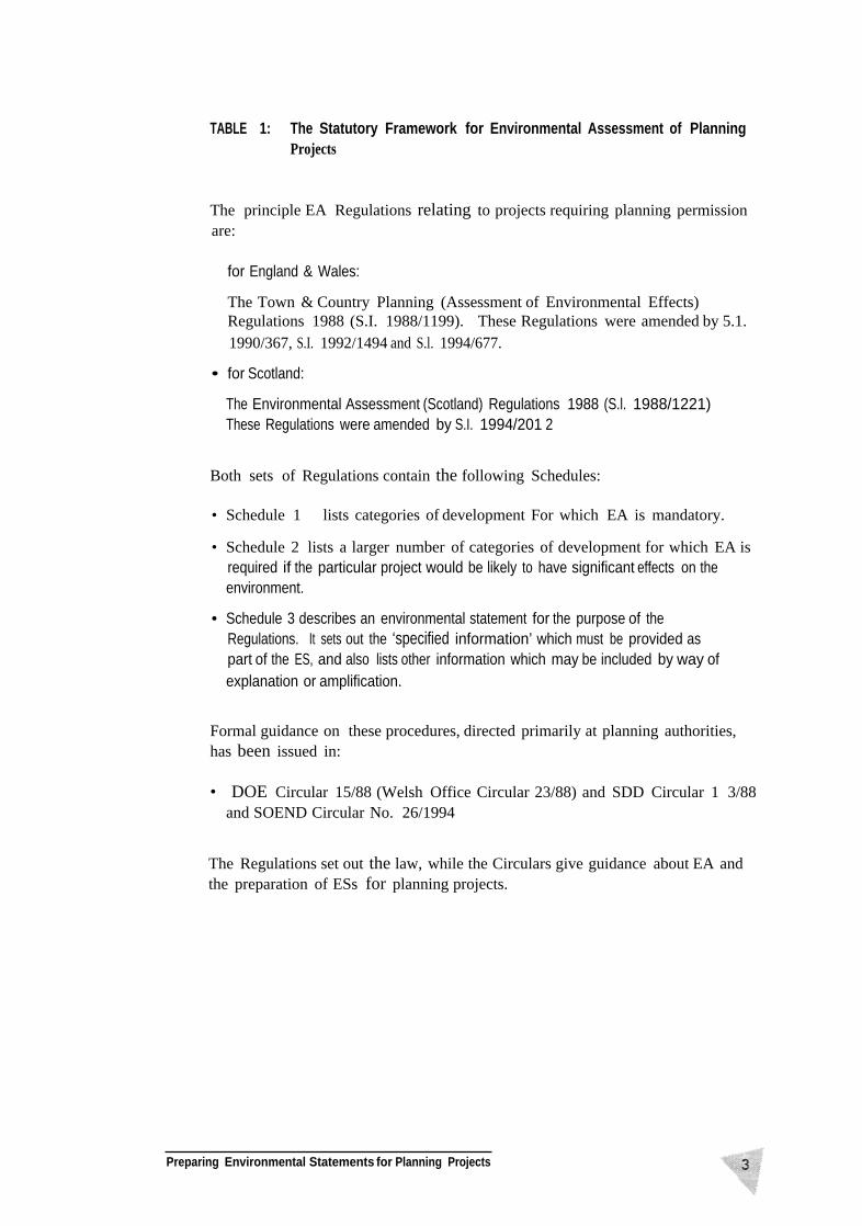
Both sets of Regulations contain the following Schedules:
• Schedule 1 lists categories of development For which EA is mandatory.
• Schedule 2 lists a larger number of categories of development for which EA isrequired if the particular project would be likely to have significant effects on theenvironment.
• Schedule 3 describes an environmental statement for the purpose of theRegulations. It sets out the ‘specified information’ which must be provided aspart of the ES, and also lists other information which may be included by way ofexplanation or amplification.
Preparing Environmental Statements for Planning Projects
TABL E 1: The Statutor y Framewor k for Environmenta l Assessmen t of PlanningProjects
The principle EA Regulations relating to projects requiring planning permissionare:
for England & Wales:
The Town & Country Planning (Assessment of Environmental Effects)Regulations 1988 (S.I. 1988/1199). These Regulations were amended by 5.1.1990/367, S.I. 1992/1494 and S.l. 1994/677.
• for Scotland:
The Environmental Assessment (Scotland) Regulations 1988 (S.l. 1988/1221)These Regulations were amended by S.I. 1994/201 2
Formal guidance on these procedures, directed primarily at planning authorities,has been issued in:
• DOE Circular 15/88 (Welsh Office Circular 23/88) and SDD Circular 1 3/88and SOEND Circular No. 26/1994
The Regulations set out the law, while the Circulars give guidance about EA andthe preparation of ESs for planning projects.

Preparing Environmental Statements for Planning Projects
PART
UNDERTAKING ANENVIRONMENTALASSESSMENT
Preparing Environmental Statements for Planning Projects

Preparing Environnientaj Statements for Planning Projects

Chapter 1 PLANNING AN ENVIRONMENTALASSESSMENT
A systematic approach - defining the brief - determining the content - establishing aprogramme and timetable - assembling the project team - establishing environmentaltrends - considering existing plans and policies
EA: A SYSTEMATIC APPROACH
1.1 Planning authorities should always obtain the information they consider necessaryto determine a planning application, including information about environmentaleffects. What is different about EA is the emphasis on the systematic analysis andpresentation of information about environmental effects. The analysis shoulduse the best practicable techniques and available sources of information. Thepresentation should be in a form which provides a focus for scrutiny of the projectby those with specialist knowledge as well as non-expert decision makers andinterested members of the public. It should also allow the importance of thepredicted effects, and the scope for modifying or mitigating them, to be properlyevaluated by the planning authority before a decision is taken.
1.2 To be systematic, the analysis should -
l through baseline studies examine the environmental character of the area likelyto be affected by the development;
l identify relevant natural and manmade processes which may already bechanging the character of the site;
l consider the possible interactions between the proposed development andboth existing and future site conditions;
l predict the possible effects, both beneficial and adverse, of the developmenton the environment; and
l introduce design and operational modifications or other measures to avoid,minimise or mitigate adverse effects and enhance positive effects.
1.3 The analysis may indicate ways in which the project can be modified to anticipatelikely adverse effects, (for example, through the identification of a better practicableenvironmental option)’ , or by considering alternative processes. If this is done,the formal planning approval stages are likely to be more straightforward. The
’ The concept of Best Practicable Environmental Option (BPEO) is incorporated into Integrated Pollution Control (IPC)under the Environmental Protection Act 1990. For developments subject to IPC, applicants for IPC authorisation mustdemonstrate thar the BPEO has been determined.
7Preparing Environmental Statements for Planning Projects

mosteffectiveenvironmentalpoiicyconsistsin preventingthecreationofpollutionor nuisancesatsourceratherthansubsequentlytrying to counteracttheir effects.
1.4 In practice,the level of attentiongiven toindividual environmentaltopics in anEA shouldreflect the significanceof potentialimpactsandtheir importancetothe decision making process.This, in turn, will determinethe amount ofbackgroundwork which needsto be undertaken,the timescalefor the studies,andthe content, structure,andlengthof theES, which aredealt within PartIIof this Guide.
DEFINING THE BRIEF
1.5 In planninganEA, the developerwill needto balance awiderangeof competingdemandson resourcesof time and money.The requirementswill include:
• determining thecontentof the EA;
• establishingaprogrammeandtimetable;and
• assemblingtheprojectteam.
Determining the Content of the EA
1.6 The scope andcontentof the EA will be determinedby the natureof thedevelopmentproposal,the alternativesunderconsideration,and the rangeandcomplexityof the issuesto be investigated.It is desirable topreparea brieffor aninitial siteappraisaland reviewof potential environmental concerns,leading tothe production ofa ‘scoping’ report. This documentwill describethe keyenvironmentalissuesto be addressed in the LAanddefine theextentof “baseline”surveysrequired to establishexisting environmentalconditions on andsurroundingthedevelopmentsite againstwhichpredictions about futurechangebothwith andwithout the projectcan bemade.
1.7 Detailedtechnicalstudies covering aspectsof the project’sengineeringfeasibilityandeconomicviability mayhavetorunin parallelwith theenvironmentalbaselinesurveys.At critical stagesin the EA, findings from thesedifferentstudiescan bedrawn togetherto review optionsand to eliminateor refine alternatives.Thisleadsultimately to theselectionof a preferreddevelopmentoption. Theprocessof progressivelyrefining the project designcan be assistedin some casesbypreparingapreliminaryESwhich is circulatedwithin the projectteamandmorewidely, as appropriate.
Establishing a Programme and Timetable
1.8 A view shouldbe takenat theoutsetof the lengthof time requiredto completethe differentphasesof work. This will be dictatedin part by the stageat which
Preparing Environmental Statements for Planning Projects

the EA is initiated, the complexityof the proposals,commercialand financialconstraints,andtheneedfor original surveywork.This mayin turnbeconstrainedby theweatheror seasonof the year.
1.9 There is of courseno absolute timetablefor completingan environmentalassessment. For amajorEA it mayrun for 12-18monthsfrom the decisiontoinitiate the EA to productionof the final ES. This reflects a situationwherebackgroundinformation on,for example, floraandfauna,climatic conditionsandnoiseanddust,may needto be collected over afuii year inorder to identifyseasonal variations. For someschemes,for example,whereriver quality or airpollution maybe involved,timewill be requiredto reflect changes inweatherandotherconditions.Suchrequirementsunderlinethebenefitsof initiating theEA earlyin the designof the project.
1 .10 In othercases,particularlyfor smaller projects,thetimescale forcompletingtheEA maybe shortenedsignificantly wherebackgroundinformation has alreadybeencollectedin earlier studies, orwherethe numberof environmentalissueswhich areconsideredto beof direct relevanceto thedecisionis small.
1.11 Figure 1 shows a typicaltimetablefor an EAspreadover a 12 month period.‘What appearsasa simple linearprogressionofactivitiesis, in practice,an iterativeprocessof review, and evaluationas the planninganddesignof the project isprogressively refinedand improved.
FIGURE 1: Typical Timetablefor EA
Task Project Month
Briefing
Site Appraisal
Scoping Report
Baseline Surveys
Technical Studies
Review of Options
Elimination of Options
Preliminary ES
Studies of Preferred Option
Draft Final ES
Final ES
Preparing Environmental Statements for Planning Projects
1 2 3 4 5 6 7 8 9 10 11 12
Assembling the Project Team
1.12 The developerwill needto considerwhetherthe necessaryin-houseresourcesandprofessional expertiseare availableto handleall stagesof the work. Wherethis is not thecase,or thereis seen to bemerit in havingan external assessment,part or all of thework maybecontracted out.
1.13 Where feasibility studies are led by individuals who are not trainedinenvironmental planning,it may be appropriateto consideremploying anenvironmentalspecialistwithin the designteamwhoshouldbe able tocommenton the environmentalimplications of alternativesanddesign options,and toadviseon theappropriatestageatwhichto launcha full EA.
1.14 Organisationsdrawing on ‘in-house’ project managementandspecialistenvironmentalskiiis,shouldconsiderhowto givethoseresponsiblefor conductingthe EA an identity which minimises any perceivedrisk of bias and lack ofobjectivity. A similar approach mayalso be appropriatefor local authoritystaffinvolvedin proposalswherethe authorityis both thedeveloperandthe planningauthorityresponsiblefor takingthedecisionon whetheror not theprojectshouldproceed.
1.15 For thoseEAs involving large orcomplexproposals,it may be appropriatetoappointaprojectmanagerto overseetheconductandproductionof the EA.Themostimportantskills of the projectmanagerare likely to be; experienceof thefull processofEA, an adequatetrainingin methodsandtechniques,andpreviousexperiencein contributingto ESs. Typically, the role of the project managerwould be to:
• co-ordinatethe efforts of teammembers(who may be unrelatedspecialistsbased indifferentorganisations);
• liaise with the developer,the design team, thelocal planningauthorityandotherconsulteesandlocal communitygroups;
• integratethe specialistassessmentswithin theES;
• makecritical judgementsregarding theinteractionsbetweeneffectsidentifiedfor the differenttopic areas;and,
• deliver theprojectwithin time and to cost.
1 .16 The principalaimof theprojectmanagerwill be to ensurethatthework proceedsalong the lines establishedduring the scopingprocessandensurethat theconclusionsof the LA are in a form that will be usefulfor the decision-makingprocess.
Preparing Environmental Statements for Planning Projects

ESTABLISHING ENVIRONMENTAL TRENDS
1.17 The environmental conditionson thesite at the time of the baselinestudywillbeexaminedin detail. But theprocessesofchangethatareoccurringindependentlyof the developmentare equally important. Theseprocesseswill affect theenvironmentalconditionsandit ispossibleto forecastwhatconditionswill prevailwithout the development.These futureconditionsare often called the “do-nothing” option andrepresenta useful baselinecomparison.
1.18 Those undertaking theLA should establishwhat changes haveoccurredin thepastandmakea forecastof future trendsoverthelifetime of aproject.Examplesofsuchprocessescaninclude siltationin rivers,lakesandestuariesresulting fromalterationsin land use practices; changes in thecompositionof grasslandsas aresultofchanges infarmingregimes;andincreasesin trafficon local road networks.Forecastingthe natureandrate of future changeis not an exact science.It isimportantthereforethat theassumptionsandbasisfor any predictionsareclearlydefined anda realistic rangeof projectionsemployed.
CONSIDERING EXISTING PLANS AND POLICIES
1.19 The plansandpoliciesoflocalauthoritiesandotherbodieswith majorinfluenceoverland useandenvironmentalqualitystandards(including thedevelopmentplan for the area) should be carefully examinedas part of the review ofenvironmentaltrends.Theyshould also serve as a basis for establishingwhatenvironmentalconditionsarelikely to existduringthe constructionandoperatingstagesof the project. Theremay, for example,be plans for newhousingin thevicinity of thedevelopmentsitewhich wouldaffect noiseandotherenvironmentalhealthstandards.The study of plans andpolicies providesthe opportunitytoidentifythose elementsofadevelopment proposalwhichconflictwith, orsupport,establishedstrategies.It maythenbe possibleto introducedesignmodificationsto minimiseadverse effects,or to ameliorateor mitigate their consequences.
Preparing Environment& Statements for Planning Projects

Preparing Environmental Statements for Planning Projects
Chapter 2 PRELIMINARY PROCEDURES
Defining the scope of the EA - preliminary consultations - significant environmentalissues - standard checklists and matrices - baseline studies - alternatives, need and demand- public consultation - project specification - defining requirements for baseline surveys
2.1 In order to carry out the process of analysis, appraisal and evaluation which liesat the heart of EA, a methodical approach, which would normally include thefollowing stages, should be adopted.
DEFINING THE SCOPE OF THE EA
2.2
2.3
2.4
2.5
2.6
Defining its scope is one of the most critical parts of an E A in that it sets thecontext for what follows. If the scope is defined too narrowly, some critical areaof uncertainty or adverse impact may emerge late in the day. Decisions on theshape of the project may then be too far advanced to allow for any real change.On the other hand, if the scope of the work is coo loosely defined, then muchtime, effort and cost may be spent on pursuing unnecessary detail.
Effectively, scoping is the key to a good quality Environmental Statement. Table2 (summarised from a fuller list at Appendix 4 to Environmental Assessment: AGuide to the Procedures) offers an outline checklist of matters to be consideredwhen defining the scope of the EA.
It is also important to be aware of other relevant procedures targeted at specificenvironmental issues. In particular, the integrated pollution control and localauthority air pollution control systems established under Part I of theEnvironmental Protection Act 1990 both require an assessment of environmentalconsequences co accompany applications for authorisation. In order to minimisethe costs and burdens imposed on business and any delays associated withnegotiating separate applications consecutively, developers may avoid undesirableduplication by preparing them in parallel. Much of the information required forthese two applications will be comparable.
A summary of the main pollution Control systems is included in Planning PolicyGuidance Note 23 - ‘Planning and Pollution Control’.
In the case of developments which are likely to have a significant impact on theenvironment only in a clearly defined and limited field, the scoping exercise willpermit subsequent work to be concentrated on one or two environmental topics.
Preparing Environmental Statements for Planning Projects

TABLE 2 : Checklist of matters to be considered for inclusion when scoping an EA
2.7 The main functionof thescopingexercise will be toconfirm the natureof thedevelopment,the breadthof the EA, the rangeof key issuesand the extenttowhicheachenvironmentaltopic areaneeds to beinvestigated.It will also starttodefine theareasof physical surveyrequired,althoughthis canonly be confirmedoncethe baselinestudieshavebeen initiated.
Preliminary Consultations
2.8 The CircularsandGuide to Proceduresrecommendthatdevelopersproposingprojects shouldhavefull andearlyconsultationwith both theplanning authority
Preparing Environmental Statements for Planning Projects
a Information describing theprotect
• purpose and physical cbaractenstics
• land userequirements arid physical features
• production processes and operational features
• alternative sitesandprocesses
b Information describingthe sste and its enysronment
• physical features
• policy framework
c Assessment of effects
• on humans, buildings and man made features
• on flora and fovna
• onland
• on water
• on air and citmate
• other indkect and seccndoiy effects
d Mitigating measures
e Risks of accidents and hazardous development
andotherbodieswhich have aninterestin the likely environmentaleffects.Theplanning authorityandstatutoryconsultees’shouldbe invited to participateindefining the termsof referenceof the EA. Theymayhavespecificknowledgeorinformationaboutthesiteandmaybeableto offer thebenefitsof theirexperienceandexpertise.If the natureof theproposalsandtiming of theFA poseproblemsof commercialconfidentiality,preliminaryconsultationsmaybe donethroughinformalandconfidentialdiscussion.
Significant Environmental Issues
2.9 The rangeof environmentalissuesor topicswhich are relevant inanyparticularcircumstancewill reflect thenatureoftheproposals,their scaleandtheir location.For example, activities likemineral extraction,waste disposalthroughlandfill,and road constructionoftenhavethepotentialto affect thewaterenvironment;whereaspower generationand incinerationraise importantquestionsaboutairandclimate. As a generalrule,the larger thesite area affected by adevelopmentthe more likely it is that significant environmentaleffects will result; but thenatureand location of the developmentare more important considerations.Proposeddevelopments locatedwithin, or adjacentto, areasdesignatedfor theirnatureconservation,landscape,geological,or archaeologicalimportance,(suchas NationalParks,NationalScenicAreas,conservationareas,etc) requirecarefulscrutiny.
2.10 The identificationof key environmentalissuesmaybe basedupon:
• Use of standardchecklistsandmatrices;
• Use of independentadvisers;or,
• Preliminaryconsultation withstatutorybodies.
Use of Standard Checklists and Matrices
2.11 A rangeofmethodsexist toassistthe developer or theassessmentteamdefinethescopeof an EA. Theseinclude the useof checklistsandmatricessuch as thatatFigure 2, inchapter7.
2.12 Wherechecklistsandmatricesare used,it is desirablethatindividual membersof the assessmentteamshould fill in their perceptionsof the critical areasofpotentialimpact, basedon pastknowledgeandexperience.It mayalsobehelpfulto ask the planning authority to commenton the checklist or matrixindependently.Any difference inemphasiscanthenbe identified and areasofdisagreementresolvedthroughdiscussion.
For EnglandandWales,a list of statutoryconsulteesis given in Article 10 of theTown and CountryPlanning (GeneralDevelopmentProcedure)Order1995,and theEARegulations.For Scotland,seeSchedule4 to theEnvironmentalAssessment
(Scotland)Regulations1988.
Preparing Environmental Statements for Planning Projects

The Content of Baseline Studies
2.13 A comparisonof the detailsof the development proposalwith what is knownabouttheenvironmentalconditionsof thesiteandits surroundingsshould identifythe natureof baselinestudiesrequired.It will thenbe necessary todecidewhatlevel of detail is neededon individual topics such as water, air, ecologyandlandscape. This raises the questionof significance sincethe EA PlanningRegulations(Schedule3, paragraph2) require thatthe ESshouldcontain:
• the datanecessaryto identifyandassessthemaineffectswhichthedevelopmentis likely to have on theenvironment;
• a descriptionof the likely significant effects, direct and indirect, on theenvironmentof the development;and
• wheresignificantadverse effectsare identified,a descriptionof the measuresenvisaged inorder to avoid, reduce orremedythoseeffects. (seeTable7)
2.14 Paragraph3(e) of Schedule3 to theEA PlanningRegulationsprovidesthat thedescriptionoflikely significantdirect and indirecteffectsmayincludesecondary,cumulative, short,mediumandlong-term,permanent,temporary,positiveandnegativeeffects. Theinclusionof positiveor beneficialeffects,aswell asnegativeor adverse ones,is importantsince a balanced EAshouldgivedueweightto bothtypesof impact.
Consideration of Alternatives, Need and Demand
2.15 Anotherissuewhich shouldbe addressed in thescopingexerciseis howto handlealternatives,needanddemand.It isgenerally thecasethatthe mainopportunitiesfor consideringalternativecoursesof action, and evendifferent developmentsitesandprocesses,arise in theearlystagesof a newproject. Veryoften,decisionson the rangeof alternatives to beconsideredwill needto be takenwith only abasicamountofdetailedinformationatthefeasibilitystudystage.Environmentalissueswill be oneof thefactorsinfluencingthe choice,andtheywill needto bebalancedagainsttechnicalfeasibility andcost.
2.16 In the EAPlanningRegulations,the considerationofalternativesis not includedwithin the ‘specifiedinformation’ which mustbe containedin an ES. However,it is includedin paragraph3(d) of Schedule 3,aspartof thefurther informationwhich may be includedby way of explanationor amplification of thespecifiedinformation(see Table7) andit is generallyhelpful to showwhatalternatives,ifany,havebeenconsidered.
2. 17 The Guideto Procedureshighlights thebenefitsof startingtheEAat the stageofsite selectionand,whererelevant, process selection.This allows for the practicalconsiderationof alternativesandhelps to avoid delayif importantissuesemergelater.
Preparing Environmental Statements for Planning Projects

2.18 Thereare certain types of project for which the issue of alternativesis morerestricted,such as the extractionof a mineralore which can only be mined insitu. However,even in thiscasetheremaybeopportunitiesfor varyingthelocationof processingplant,accessroutesor power transmissionlinesservingthesite. Inotherexamples,like the planningof a new reservoir,there maybe anumberofpotentialoptions. If theenvironmentalprinciplescontributingto theeliminationof variantsare carefullyrecordedat the time of the decision, this will greatlyimprovethe credibility andoverall objectivity of theeventualES.
2.19 There is no requirementin the EA Regulationsthat a developershoulddemonstratea provenneedor demand fortheproject when producingan ES.In manycases,the questionof needor demandwill be dealt with underotherlicensingor authorisationprocedures.In others,the issuewill be irrelevanttothe basic questionof the extentto which theproject may or may not havesignificanteffectson theenvironment.However,demand forenergyandnaturalresources,and the effects of their consumptionon the overall state of theenvironment,are recognisedasincreasinglyimportant.Whereneedanddemandare shownto have direct links toenvironmentalquality, thesemaybe materialconsiderationsin the contextof the planningdecision.
Deciding on the Role of Public Consultation
2.20 While developersare under no obligation to publicise their proposalsbeforesubmittinga planningapplication,consultation withlocal amenitygroups andwith the generalpublic can be useful inidentifying key environmentalissues.Suchconsultationmayput the developer in abetterpositionto modifytheprojectin wayswhichwould mitigateadverse effectsand recogniselocal environmentalconcerns.It will alsogivethedeveloper anearlyindicationof theissueswhicharelikely to beimportantattheformalapplicationstageif, for instance,theproposalgoesto public inquiry.
2.21 It is at thescopingstagethatthe developershouldconsiderthemostappropriatepoint atwhich to involve membersof thepublic. Developersmaybe reluctantto makea public announcementabouttheir proposalsatan earlystage,perhapsbecauseof commercialconcerns relating tolandpurchasenegotiationsor perceivedchallengesfrom rival companies.There may also be occasionswhen publicdisclosureof developmentproposals in advanceof a formalplanningapplicationmay causeunnecessaryblight. However, early announcement ofplans forprospectingandsite or routeselection,and the provision of opportunitiesforenvironmental/amenitygroupsandlocal people tocommenton environmentalissues,maychannellegitimate concernsinto constructivecriticism.
PREPARING A PROJECT SPECIFICATION
2.22 Promotersof a projectwill wish to ensurethat thoseconcernedwith its designand thoseconcernedwith theEA work closely together.It is at thisstage in the
Preparing Environmental Statements for Planning Projects
project’s evolution that the greatestopportunityexists for minimising adverseeffectsandmaximisingenvironmentalbenefits.
2.23 Oneway to encouragethis is to preparea projectspecificationwhich:
• describeswhat is knownabouttherequirementsof theproject;
• identifies the rangeof uncertaintyapplyingto specific aspectsof the design;and,
• starts to spellout potential environmentalimpacts.
2.24 For example, theprojectspecificationmight containan estimateof thevolumeof materialto betransported andthenumberof vehiclemovementslikely to begeneratedin an averageweek. Suchinformationwill providethe FA team withthe basisfor examiningpotentialdisturbanceto local communitiesfrom trafficmovementandnoise,andfor makingrecommendationson waysof minimisingnuisanceandinconvenience.Projectspecificationsshouldbe updatedat regularintervalsas the designof theproject is modifiedandredefined.
DEFINING REQUIREMENTS FOR ENVIRONMENTAL BASELINE SURVEYS
2.25 As a resultof thescopingexercise,apicture shouldemergeof theenvironmentalissuesto beinvestigatedin baseline surveys.Thesearelikely to includethesite ofthe development,its accessand anyother areaslikely to be disturbedduringconstructionandoperation.
2.26 However, theboundariesof studyareasmay needto extendover muchwiderareasto encompassthe full rangeof direct and indirect environmentalimpactswhichcould follow from development.Forexample,landscapesurveys willusuallyincludethe zoneof visual influence- generallyall landwhich is visually linkedwith the developmentsite. Hydrological andecologicalsurveysmay needtofollowstreamsor rivercoursesfor considerabledistancesdownstream(andpossiblyupstream)depending uponjudgementsabout the concentrationsand likelydispersalpatternsof effluent to bedischargedfrom the newfacility. Thus, thedefinitionof baselinesurveyareasis an extensionof the scopingprocessandmayneedto be refinedprogressivelyas informationcomes tolight.
Preparing Environmental Statements for Planning Projects
Chapter 3 PREDICTING IMPACTS ANDFORMULATING MITIGATINGMEASURES
Identifying potential impacts - describing resources and receptors - cause and effect -predicting the nature and extent of impacts and magnitude of effects - selecting methodsof prediction - uncertainty - fact, judgement and opinion - mitigating adverse effects -evaluating impacts - hazard and risk assessment
3.1 Impact prediction involves the analysis of potential causes of change to the existingenvironment and determination of likely effects. The magnitude or physicalextent of predicted impacts should be presented in quantifiable terms whereverpossible.
3.2 The ‘basic stages of impact prediction are:
identifying the activities in the development process likely to generate impacts,both positive and negative;
identify resources and receptors likely to be affected by those impacts;
establish the chain of events or pathways linking cause with effect;
predict the likely nature, extent and magnitude of any anticipated changes oreffects;
evaluate the consequences of any impacts identified; and,
establish which potential impacts (positive or negative) should be regarded assignificant.
Identifying Potential Impacts
3.3 The scoping stage of the EA should have identified the key topic areas in whichthe development has the potential to cause either adverse or beneficial effects onthe environment. Each of these elements should be reviewed in terms of its capacityto affect the environmental baseline conditions (including environmental trendsand anticipated changes). Manuals and guidelines produced for specific types ofdevelopment may be useful here.
Preparing Environmental Statements for Planning Projects

3.4 Thereisextensiveliteraturein thetechnicalpress onmethodswhichmaybe usedto examinepotentialimpacts,includingnetworks,matricesandsystemsanalysis.Illustrativeguidancerelatingto individualenvironmentaltopics is setout in theAppendicesto this Guide.
Describing Resources and Receptors
3.5 Developmentprojectsmayaffect onlya fewdiscreteareasof the environment,orthey mayaffectacompleteecosystemor geographical region.While it is importantthatthe environmentshould be consideredasasingleentity,it is usuallyconvenientto subdivide potentialandpredictedimpactsby topic. Thesemaybe physicalresourceslikewaterorsoil, or individualspeciesofplantsor animalswhichbecomethereceptorsof specific impacts.
3.6 The EA PlanningRegulationsrequire the ES to include environmentaltopicscoveringhumanbeings,flora, fauna,soil, water,air, climateandlandscape.Theyalsorequireit to includethe interactionbetweenthese factorsandto examinetheeffectson materialassetsand the culturalheritage.
3.7 ‘Material assets’is not definedin the EAPlanningRegulations(nor in the EIADirective). The term is generallytakento include buildingsandother man-madeartefacts(althoughthat is not an exhaustivedefinition). Thus, although‘materialassets’andthe‘cultural heritage’appearas separate topics inSchedule3to theFA PlanningRegulations,theyare treatedin this Guideas a singletopicarea. The term maybe further clarified as a resultof amendmentsto the ETADirectivecurrentlyunderdiscussion.
3.8 Within thisframework,it ofren helps toconsidereachtopic undera numberofdifferentsub-headings(seeTable 3 andNote).
3.9 In assessingpotential impacts,it is desirableto note the distinction betweenprocesseswhichgive rise to impactsandtheeffectswhich such impactshave onthe basic resource orreceptor.For example,it is nowpossibleto usesophisticatedequipmentto predictincreasesin soundfrom mechanicalplant andthescopeforreducingor attenuatingthe resultingnoiselevels. Butwhat mattersin the finalanalysisis howthese changes innoiselevelwill affecthumanbeingsand/orfauna.Theanswerwill dependupon manyvariedfactors.Sinceit is usuallyimpracticableto assesstheeffectsof noise on everyindividual, ‘target’ groupsareselected suchas peopleworkingin immediatecontactwith thesource,or livingwithin aspecifieddistance,or engagingin a particularrecreationalactivity.
3.10 Anotherexampleof the useof ‘target’ groupsis the identification of ‘indicatorspecies’in studiesofflora andfauna. Salmonoidfish, for example,areparticularlysensitiveto oxygen levelsandheavy metals inwater. If these fishare presentin awatercoursewhereeffluentdischarges from thedevelopmentwill not giverise toconcentrationsof pollutantswhichwould harmthesespecies,it maybeassumedthatmoretolerantspecieswill also beunaffected.
Preparing Environmental Statements for Planning Projects

populationhousingnoise and vibrationair/water and landpollutioninfrastructure/servicesland use
agriculture- recreation
forestrymineral resourceswaste disposal
heat, chemical, odorousand gaseous emissionsparticulate matter
architectural inte restarchaeological interesthistoric interestancient monuments
TABL E 3: Exampl e Lis t of Environmenta l Topics
EA PlanmngRegulationsEnvironmental TopicsHumanBeings
ExampleSub-headings
Flora and Founa
Soil
habitatsplant and animal communitiesindividual species
Water
geologygeamorphologyagricultural land quality
Air and Climae
hydrological cyclesurface water tergroundwatercoastal/estuarine
Landscape landform/topographyland use ..: .
land coverlandscape characterlandscape quality
Cultural Heritage and.Material Assets
*Note:This list is intended to be exhaustive; nor will all the sub-headings berelevant in every case
Preparing Environmental Statements for Planning Projects

Examining Pathways Linking Cause with Effect
3.11 Thelinks between sourcesofpollution (or theinitial causeof animpact)andthereceptormay be direct orindirect. Substances dispersedin flue gasesfrom achimneycan, for example, have adirect effect on vegetationor theymay bedissolved inwaterbefore affecting their ultimate receptor.Pollutants generallybecomemore diluteastheyaredispersedfromsourcebut therearecircumstanceswheretheycan becomere-concentratedin living tissuesas they passalongthefood chain. Linkagesbetweenpathwaysmustalso beconsideredsincechangesin onemediumcanaffect another.Changesin watertemperature,for example,can influenceratesof chemicaldiffusion andabsorption.
3.12 Analysisof pathwaysmaylead to theidentificationof successivechangeswhichmaybe describedas first, secondandthirdorderimpacts.Forexample,anincreasein suspendedsolids inwatercan reduce lightpenetration,slowingdown the rateof photosynthesisin algaeandprovidinglessfood for fish. This resultsin fewerandsmallerspecimensandmight leadultimately to thedeclineof a commercialfishery. In thiscase,water, faunaandhumanbeings areall affectedeitherdirectlyor indirectly by thechanges.
Predicting the Nature and Extent of Impacts and the Magnitude of their Effects
3.13 Eachof the impactsidentified in the courseof the EA needs to beconsideredintermsof its basicnature, thephysicalextentof its influence, and the magnitudeof its effects. In consideringthe natureof impactsit will be necessary toassesswhetherthe effectswill be:
• director indirect
• short,medium or long-term
• reversibleor irreversible
• beneficial or adverse
• cumulative.
Thesecriteria are also relevantwhen evaluatingthe significanceof an impact,discussed inparagraphs3.24-3.28.
3.14 For example,the natureof the impact arisingfrom dischargingheatedwaterfrom apowerstationwill be anincreasein the averagetemperatureof thereceivingwatercourse.This will have direct long-term impactswith both adverseandbeneficial effects. The physicalextent ofthe impactwill be dependenton therelative volumesof waterinvolved andthe degreeof mixing whichoccurs. In alargeestuarythe effectsmaybe dissipatedrapidly over a verywidearea,leading
Preparing Environmental Statements for Planning Projects

to only a slight increase in temperature. In a river or lake, the effects may be more confined leading to appreciable rises in temperature. The magnitude of the effects in both cases will depend upon the baseline ecological conditions of the receiving water, and any critical thresholds in the tolerance of plants and organisms to increases in temperature. If there is more than one power station on a river, their individual impacts on water temperature may be slight but the cumulative effects could be significant.
Selecting Methods of Prediction 3.15 Methods of prediction will differ according to the environmental topic under
investigation. They will often include a combination of qualitative and quantitative techniques, as in the assessment of noise pollution illustrated in Table 4.
3.16 Qualitative techniques rely heavily on previous experience and knowledge of the consequences of certain types of action. Quantitative techniques usually seek to model the natural environment. Examples of modelling include the analysis of the time and concentration of storm run-off from an urban catchment; the dispersal patterns and dilution of flue gases from chimney stacks; and the distribution of noise contours around an airport. With such models it is possible to derive confidence limits relating to the accuracy of the predictions. Other effects are more difficult to quantify since they may result from poorly understood pathways and/or inadequate data. The extent and limitations of current knowledge should be clearly stated in any predictions.
TABLE 4: Example of Assessment of Noise Pollution
Preparing Environmental Statements for Planning Projects
A Typical Assessment of Noise Pollution will involve Establishing the ambient noise levels by day and night around the site through baseline surveys; Obtaining (from manufacturers’s specifications, or existing developments) a full Spectral analysis of noise outputs for the types of equipment and plant proposed on The site; calculating the increased (or decreased) noise levels which will rise at point (or linear) sources within the site;
calculating the degrees of noise attenuation afforded by distance, screening or othermitigating measures between the point of origin and the receiver; predicting the increase in resultant noise levels; relating the findings to established standards for noise control in industrial or residential areas or to other yardsticks where standards are not available (eg noise in the countryside); estimating the number of people and types and locations of found directly or indirectly affected by increases in noise of varying intensity.

Dealing with Uncertainty
3.17 Uncertaintymayarise inthe courseof an EA in trying to predict:
• the probability of an eventoccurring;
• the severityof theevent,whenit occurs;
• the consequencesstemmingfrom an event;and,
• interactionsbetweentwo or moreevents.
The reliability of the methodsused to carryout theaboveassessmentsmayalsobe uncertain.
Formoststudiesit will besufficientto notethedegreeofuncertaintyattachedtodifferent predictions.But wherehealthand safety is a major issue, fullhazardandrisk assessmentmaybe requiredas part of a separatestudy. (See3.29-3.31)
Fact, Judgement, and Opinions
3.18 Theanalysisof environmentalimpacts usuallyinvolvesa progressionfrommattersof fact,which can bestatedwith certainty,througha processofscientificappraisalor professionaljudgement,to theexpressionof opinionson therelativesignificanceof the findings. A clear distinction should be drawn between mattersof fact,judgements andopinions,and all sourcesidentified.
3.19 One ofthe meritsof an ES inwhich theseelementsareclearlypresentedis thatagreementcanusuallybe reachedbetweenthedeveloper,planningauthorityandinterestedparties on thesubstantivefacts,leavinganydebateto theinterpretationsto be placedon thosefacts. If thereis confusion,the scopefor argumentandpotentialdelayis muchgreater.
REFINING THE PROPOSALS TO MITIGATE ADVERSE EFFECTS
3.20 A fundamentalaim of usingEA proceduresas an integral part of the designprocessis to ensurethatpotentially damagingeffects areavoidedor minimisedandthebeneficial aspectsareenhanced.This processwill usuallytakeplace in acontinuouscycle astheproposalsfor the developmentare refined. Consultationwith pollution control authoritieswill be animportant aspectof identifyingsuitablemitigation measures,particularly sinceauthorisationconditions forpollution control will fall primarilyto HMIP1(HMIPI’ in Scotland) to determine
As from 1st April 1996. in Englandand Walesthe EnvironmentAgency will take over the functionsof Her Majesty’sInspectorateofPollution and in Scotlandthe ScottishEnvironment ProtectionAgencywill takeover the functionsof Her
Majesty’sIndustrialPollution Inspectorate
Preparing Environmental Statements for Planning Projects

(in thecaseof IPC processes).Threetypesof mitigation maybe considered:
• avoidance;
• reduction;
• remedy.
3.21 The most satisfactoryform of mitigation is to avoid environmentaldamageatsourcethroughre-design.Reductioninvolveslesseningtheseverityof an impactwhich cannotbe avoidedentirely. Remedy(whichmayincludeenhancementor compensation)acknowledgesthat someadverseconsequenceswill stem fromthe development,but provides means bywhich theconditionscan beimprovedor compensatedfor.
3.22 Table5 provides some examplesof what thesemight meanin practice.
TABLE 5: Examples of Mitigating Measures
3.23 An ES should makeclearwhichelementsof thedevelopmenthavebeenintroducedto mitigatepotentialadverseeffects.
EVALUATING IMPACTS AND THEIR EFFECTS
3.24 One ofthemostimportantparts ofthe EA processis to attachsomemeasureofsignificanceto impactpredictions.Environmentalqualitystandards mayprovidea framework for evaluation wherethese laydown acceptableandunacceptablelimits of polluting substances in air or water.If, for example,it can beshownthat emissions to airwill not lead toincreasesin gasesin excessof the naturalvariation in the rangeof concentrations,thenthe effects mightbe describedasinsignificant. If, on theotherhand,gaseousemissionsarepredictedto result indetectableincreasesin concentrations,althoughstill falling below permissible
Preparing Environmentat Statements for Plannrng Projects
Avoidance
Noise
Reduction
Use on inherentlyquieter machine
Remedy
Fit sound insulationaround the machine
Effluent
Provide or pay ~ordouble glazing onnearby houses
Change process toeliminate effluent
Either change to aprocess with a lowertoxicity of effluent orapply onsite treatment
Woodland
Discharge effluentthrough a Longoutfall where it willhave less effect
Redesign site layoutto prevent adverseeffects
Modify proposalsto minimise treefelling
Plant new woodland
legal limits, the results might be described as minor or of some significance.Emissionswhich are likely to result in a breachof a legallydefinedvaluewouldclearly be of major significance.
3.25 Thereare alsoacceptedmethodsfor measuringthe impactsof noiseandtraffic,andfor relatingthese tothresholdsof tolerance, orcarryingcapacities.It is moredifficult to produceevaluationframeworksfor intangibleassetslike the publicperceptionoflandscapevalue. However,it is possibleto reach aconsensusthrough‘panel’ interviewsandothersampling techniques.
3.26 The evaluationprocess willusuallyinvolve consideringthe significanceof animpactundera numberof criteria:
• extentand magnitude;
• short-term andlong-term;
• reversibility andirreversibility;
• performanceagainstenvironmentalquality standards;
• sensitivityof the receptor;
• compatibilitywith environmentalpolicies.
3.27 It may sometimesbe helpful to attach scoresto criteria to indicate levels ofsignificance.Scalingandweightingcan be useful indistinguishingbetweentherelativeimpactsof alternatives.Forexample,in assessingthe effectwhich threedifferentpipelineroutes wouldhave onthe ecologyof a particulararea,onesetof valuesmight relate to thelengthof pipelinecrossingheathland,which oncedisturbedtakes along timeto restore;anothermight relate todesignationssuchas SSSIorAONB; a third could involve lengthsof pipeline crossinghigh qualityagriculturalland. By alteringthe relativeweightattachedto eachof these(andother)criteria,therelative sensitivityof the routescan beassessed.This methodof analysiscanbe opento criticism that the scalesandweights are subjective.Sensitivitytestsshouldtherefore be carried out on thescalesandweightsattachedto the differentcriteria.
3.28 Whensettingup theframeworkfor evaluatingimpacts,careshouldbe takentoidentify thepracticallimitations of themethodsproposed.Quantitative methodswhich seek to establish asingle index of environmentalvalues are unlikely toassistthe decision-makerwho needsto makethe ultimatechoicebetweensocial,economicandenvironmentalconsequencesof a newdevelopmentproposal. Onthe otherhand,someindividual elementsof an assessment canbenefitfrom theapplicationof quantitativetechniques,especially in thefields of air andwaterpollution, andecology. Although thereis renewedinterestin seekingto attach
Preparing Environmental Statements for Planning Projects

monetaryvaluesto environmentalimpactsmethodsof economicevaluationarestill in the earlystagesof development. Someof theseare reviewedin ‘PolicyAppraisalandthe Environment’ publishedby HMSO for theDepartmentofthe Environment.
Hazard and Risk Assessment
3.29 In addition to thetasks listedabove,it may be appropriateto considerhazardandrisk assessment.
3.30 Identificationof hazardscalls for the systematicexaminationof all elementsofthe project’s designand their interactionswith the environmentto determinehowharmmightarise. Examplesinclude:
• naturalhazards suchaslandinstability andflooding;
• failure of engineeredstructuresunderstresssuchas dams;
• malfunctioningof plant and equipment,causingaccidentalreleaseof toxic,inflammableor explosivechemicals.
As thereis a chancethesecircumstanceswill actuallyoccur,risk assessmentmaybe needed.
3.31 Theseprocessesrequiresspecialistknowledgeandskills for their execution.Guidanceon them is availablein the publications‘A Guideto RiskAssessmentandRisk Managementfor Environmental Protection”,publishedin June 1995and“Policy Appraisaland the Environment” firstpublishedin 1991. Bothpublicationsare availablethroughHMSO.
Preparing Environmental Statements for Planning Projects

Preparing Environmental Statements for Planning Projects

PART
PREPARING ANENVIRONMENTALSTATEME NT
Preparing Environmental Statements for Planning Projects

Preparing Environmental Statements for Planning Projects

Chapter 4 ASSEMBLING THE ENVIRONMENTALSTATEMENT
Alternative approaches - structure and content - method statement - length - scopingstudy - non-technical summary
4.1 The Environmental Statement (ES) is the most visible part of the EA process. Itdraws together the findings of the developer’s technical studies prior to thesubmission of a planning application. It is the developer’s responsibility to preparethe ES and present the information in a comprehensive, clear and objective mannerfor review by the planning authority and statutory consultees. It must include anon-technical summary to assist in the process of public consultation.
4.2 By the time the task of assembling the ES is begun work should have beencompleted on:
l defining the scope of the EA;
l undertaking baseline studies;
l assessing trends; and
l considering policy and plan implications.
Preliminary findings should also have emerged from:
l analysis of potential impacts;.
l predicting and evaluating the magnitude and significance of impacts; and
l proposing mitigating measures.
However, the full effects of a project will often only emerge as the inter-relationships between environmental topic areas become clear, followingcompletion of the specialist studies It may therefore be useful to prepare a ‘draft’statement for internal consideration as part of the overall study programme.
ALTERNATIVE APPROACHES TOWARDS PREPARING AN ES
4.3. The approach chosen will depend upon the particular circumstances relating tothe project, its environmental setting and the organisation of the EA team.
Preparing Environmental Statements for Planning Projects

4.4 One way is for the contributions on particular topic areasto be written byindividual specialists. They subsequently remainresponsiblefor the precisewordingof the text eventhoughaneditorwill be responsible for theassemblyofthe document. If this methodis usedit is importantthat thelinkagesbetweensubjectareasare properly exploredandcovered. This can bedoneeither insupplementarysections or in a singlechapter writtenby the editor. Thesearebotheffectivewaysto drawtogetherthedifferentspecialistinputs. Without thiseditorial input the endproductmayappearasaloosecollectionof unrelatedandsometimescontradictorystatementsand it mayfail to meetthe requirementtodescribetheinteractionbetweenthemain effects.
4.5 Anotherapproachto writing an ESinvolves usingjust oneauthor, preferablywith experiencein EA. He or sheis responsiblefor reviewingthe findingsof theindividual specialistsandthenwriting the entire document,drawing on theworking papers. This has theadvantagethat the authorcan cross-checkandcross-referenceall the material, highlight key issues,eliminateirrelevant detailandgive thereportaconsistentstyle. On theotherhand,thereis a riskthatsomeissuesmaybe over-simplified in the process.If this approachis adoptedit isimportantthattheindividualspecialistsshouldseeandapprovethetextwhichisproducedfrom their ownwork beforepublication.
4.6 A third approach,representingan intermediate position,involves the collationof individual specialistreportsin a volumeof appendiceswhile the ‘main report’is written by oneauthor. This clarifies the individual responsibilitiesof theproduction team. But the editor should take care not to add undulyto thelengthof the documentthroughduplication.
STRUCTURE AND CONTENT OF THE ES
4.7 Thereareno statutoryrequirementsconcerningthe form of an ESbut it mustcontaintheinformationspecifiedin paragraph2 ofSchedule3 totheEAPlanningRegulations.It mayalsoincludethefurther informationsetout in paragraph30f Schedule3 by wayof explanationor amplification.Schedule3 is reproducedin Table7. Althoughthereis no prescribedformatfor an ES, the structuregivenas an example in Table 6may helpensureall the relevantissuesarecovered.
4.8 If aplanning authorityconsideranES thathas beensubmittedto be inadequate,they maywrite to thedeveloperrequiringfurther information concerning anymattermentionedin Schedule3. That further informationhas to bereasonablyrequired to enablethe authority to give properconsiderationto the likelyenvironmentaleffectsof the proposeddevelopment.The authority may alsorequire adeveloperto produceevidence toverify information in theES.
4.9 Where the ES comprisesmore thanonedocument,the statusof eachand itsrelationshipto theothersshouldbe clearlyidentified on the covers. The formatandcontentof individual chaptersin the ES will necessarily varywith different
Preparing Environmental Statements for Planning Projects

TABLE 6: An Outline Sfructure for an Environmental Statement
typesof project;the relativesizeandcomplexityof individualdevelopments;andthe natureof the significant effects. In practicethe level of attentiongiven toindividual environmentaltopics in the ESshouldreflect thesignificanceof thepotentialimpactsandtheir importanceto thedecision-makingprocess.
METHOD STATEMENT
4.10 The planning authoritymay lookfor informationaboutwho haswritten the ES,howit was preparedandwhatstudies wereundertakento justify its conclusions.This informationis not a formal requirementof the EA PlanningRegulationsbut its inclusion in a methodstatementcansavetime by reducingthework ofthe planning authorityandstatutoryconsulteeswhentheyreview theES.
4.11 Ideallyamethodstatementtakesthe readerthroughthebackgroundto the project.It describes,where applicable,the relationshipsbetweenthe promoter, theplanning, engineeringanddesign teams,andthe companyor individualsresponsible forthe ES. It alsooutlinesthe stepstakento determine thescopeofthe assessmentand deals with the programmeand timetableof the technicalstudies.
4.12 A methodstatement mayalsodiscussthelevel ofcontactbetweenthosepreparingtheESandstatutoryconsultees.It maynoteanymeetings,exhibitionsor surveysinvolving thegeneralpublic,andexplainhowissueslike alternativesandobjectivityhavebeen dealtwith. It discussestheapproachtakentowardsdetermining thescaleandsignificanceof impacts,andthe basison whichpredictionshavebeenmade. Finally it shouldmakeclearwhatguidelines,methodsor techniqueshavebeenusedin theprocess.
Preparing Environmental Statements for Planning Projects
1. A Non Technical Summary, which may also be available as a separatedocument
2. Method Statement
3. Statement of Key Issues.
4. Description of the Project5. Description of Environmental Conditions within and surrounding the site
6 Assessment of Environmental Effects by Topic Area, as set out in table 7, 2c(Each chapter should identify baselineconditions, potential impacts, the scopefarameliorationand/or mitigation of impacts, and provide a description ofunavoidable impacts)
7 Appendices of technical data

3. An environmental statement may include, by way of explanation or amplification of the specifiedinformation, further information on any of the following matterso. the physical characteristics of the proposed development, and the land-use requirements during the
construction and operational phases;b. the main characteristics of the production processes proposed, including the nature and quality of
the materials to be used;c. the estimoted type and quantity of expected residues and emissions (including pollutants of water,
air or soil, noise, vibration, light, heat and radiation) resulting from the proposed development whenin operation;
d. (in outline) the main alternatives (if any) studied by the applicant, appellant or authority and anindicotion of the main reasons for choosing the development proposed, taking into accountenvironmental effects;
e. the likely significant direct and indirect effects on the environment of the development proposedwhich may result fromi. the use of natural resources;ii . the emissio n of pollutants , the creatio n of nuisances , and the eliminatio n of waste;
f. the forecasting methods used to assess any effects on the environment about which information isgiven under sub-paragraph (e); and
g. any difficulties, such as technical deficiencies or lack of know-how encountered in compiling onyitem of soecified information.
TABLE 7: Content of An Environmental Statement
The following are the statutory provisions with respect to the content of environmental statements, as set outin Schedule 3 to the Town and Country Planning (Assessment of Environmental Effects) Regulations 1988and the Environmental Assessment (Scotland) Regulations 1988.
1. An environmental statement comprises a document or series of documents providing for the purpose ofassessing the likely impact upon the environment of the development proposed to be carried out, theinformation specified in paragraph 2 (referred to in this Schedule as “the specified information").
2. The specified information is-a. o description of the deveiopment proposed, comprising information about the site and the design
and size or scale of the development;b. the data necessary to identify and assess the main effects which the development is likely to hove or
the environment;c. a description of the likely significant effects, direct and indirect, on the environment of the
development, explained by reference to its possible impact on:human beings;flora;fauna;soil;water;air;climate;the landscape;the inter-action between any of the foregoing;materiol assets;the cultural heritage;
d. where significant adverse effects are identified with respect to any of the foregoing, a description ofthe measures envisaged in order to avoid, reduce or remedy those effects; and
e. a summary in non-technical language of the information specified in sub-paragraphs (a) to (d).
In paragraph (e), ‘effect? includes secondary, cumulative, short medium and long term permanenttemporary positive andnegative effects
4.Wherefurtherinformationis included inanenvironmental statementpursuantto paragraph3,anontechnical summary ofthot information sholl also be provided
Preparing Environmental Statements for Planning Projects
LENGTH OF ENVIRONMENTAL STATEMENTS
4.13 For projectswhich involve a singlesite and relatively fewareasof significantimpact,it shouldbepossibleto producea robustESof around50 pages.Wheremore complexissues arise,the main bodyof the statementmayextendto 100pagesor so. If it exceeds150 pagesit is likely to becomecumbersomeanddifficult to assimilateand thisshouldgenerallybe regardedas amaximum. Anyadditionalinformationshouldbe incorporatedin appendices.
4.14 However, the quality of an ES will not be determinedby its length. What isneededis a concise, objectiveanalysiswhich dealswith all the significantareasofimpact andhighlightsthe key issuesrelevant tothe decision.
SCOPING STUDY
4.15 The findingsof the scopingstudyshouldeventuallybe incorporatedin theES byindicatingwhich topicsweresingledout for detailed investigationas ‘key issues’(seethe noise exampleatTable 4) andwhich topics wereshownatan earlystageto beof minoror no significance.
4.16 The reasons forconclusionson the level of significanceincludedin thestudyshould be spelledout clearly. This will allow the planning authorityto verifythem for itselfandensurethat anydiscussionis focused onthe key issues. (See5.10)
NON-TECHNICAL SUMMARY
4.17 The EA PlanningRegulationsrequire anon-technicalsummaryto beproducedaspartoftheES. Itspurposeis to ensurethatthe findingsofthe studiesundertakencanmorereadily bedisseminatedto thegeneralpublic,and thatthe conclusionsareeasilyunderstoodbynon-expertsanddecisions makers.It is thereforeessentialthatthe non-technicalsummaryprovidesan accurateandbalancedstatementofkey informationcontainedin the ES.
4.18 It should describeall the conclusionsof the ES,and thefacts andjudgementsonwhich theyarebased.It is goodpracticeto write shortsummariesandconclusionsat the endof each section orchapterof the main statementwhich can thenbecarried forwardand incorporatedin the non-technicalsummary. This hastheadvantagethat thesamewordingis used todefinekeyissuesandconclusionsinbothpartsof thedocuments.It mayalsobehelpful topresentan overallsummarytablewhich records the relative weightsattachedto thesignificanceof individualimpacts; an exampleis given in Figure2 (seeChapter7).
4.19 The non-technicalsummaryis likely to have ahigher public profile than themain reportandmaybe printedin largenumbersfor publiccirculation. However,it should not be treated simplyas a public relationsdocument. Although the
Preparing Environmental Statements for Planning Projects

developer can take theopportunityto demonstrateanawarenessof environmentalissues,he or sheshouldavoid therisk thatbiasmaybe introducedin an effort tohighlight theproposal’smostfavourable featuresandplaydown adverse effects.
4.20 The non-technicalsummary maybe boundinto themain reportor beproducedasa separatedocument.Thereis no requirementfor it to beavailableas aseparatedocument,but to ensureadequatepublic consultationanda widerappreciationof the projectandits environmentaleffectsthere maybe clearbenefitsin doingso.
Preparing Environmental Statements for Planning Projects

Chapter 5 THE PROJECT AND EXISTINGENVIRONMENTAL CONDITIONS
Describingthe project - characteristics- phasing- alternatives- level of description-
existingconditions- selectionof material- environmentaltrends
THE PROJECT
5.1 A key elementof an ESis the descriptionof the proposed development.Thisshouldprovideacomprehensive pictureof thescheme, itspurpose, locationandscale. The projectdescriptionshould alsodescribethe alternatives,if any, thathave beenconsidered. The function of the proposeddevelopmentshould beoutlinedandset in itseconomicandoperationalcontext. The account shouldbe concise,with anynecessary detailappearinglater in the ES.
Characteristics
5.2 An introductionto thecharacterof thesite is neededto establishthecontextforthe development.Furtherdescriptionswill usuallybe providedunderchaptersof the ESdealingwith individualenvironmentaltopics.
5.3 The physical layoutof the development includingthe siting anddesignof thebuildingsshould be described.This shouldbe donenot only with written textbut using maps,drawings,sketches,photomontageandcomputersimulations,where appropriate. This helps to presenta clear visual impression0f thedevelopment’sappearance.
Phasing of the Development
5.4 The importanceof describingthe sequenceof developmentis often overlookedbut this is critical to the assessmentof the project’s potential effects duringconstructionandoperation,andin somecasesduringdecommissioning.Whereasignificanttime lapseis likely to occurbetweenphasesof the development,itmaybe useful to divide the ESinto sectionsdealingwith each phase inturn.Thelevel of accuracy inpredicting the effectsof environmentalchangeis likely todecline,the further into thefuture the worksareplanned.
Alternatives
5.5 Althoughdiscussionof alternativesis not requiredenvironmentalinformationspecified in Schedule 3of the EAregulations(seetable 7),it is generallyhelpful
Preparing Environmental Statements for Planning Projects
to say in the ESwhat alternatives,if any, havebeenconsidered.In the caseofdevelopmentproposalswhichhave noalternativesite, differentoptionsare likelyto havebeenconsideredfor featureslike earthworks,the siting anddesignofbuildings, routingof roads,andcablesandpipelines. In suchcasestheES canhelp to reducemisinformedcriticism of a project by spellingout therangeofoptionsconsideredanddemonstrating howenvironmentalfactors havebeentakeninto accountin the design process.
LEVEL OF DESCRIPTION
5.6 Skill is neededin writing up theprojectin non-technicallanguagefor thebenefitofthelay reader,while still providingsufficientdetail toensurethattheprocessesand natureof the proposedplant andequipmentcan be fully understood.Technical summariesmay needto berewrittenor expandedbecause featuresofthe plant which are self-evidentto the expertmay meanlittle or nothing toothers. This exerciseof translatingtechnicalfunctions andoperations intoeverydaylanguagemay highlight whya process,which the project designermayregardas routine,hasthepotentialto causesignificantenvironmentaldamage.
5.7 WhileeveryESis likely to bebasedon auniquesetofdevelopmentcharacteristics,the list in Table 8 provides anindicationof someof thesubjectswhichshouldbeconsideredwhendraftingthe ProjectDescription.
EXISTING BASELINE ENVIRONMENTAL CONDITIONS
5.8 It is helpful to providea generaldescriptionof the environmentalcharacterofthedevelopmentsiteandits surroundingsatan earlystagein theES.Thisprovidesthecontextfor theanalysiswhichfollows. Moredetailedobservationson baselineconditionsmaybeincludedor can follow in theintroductionsto chapters dealingwith specific environmentaltopics.
5.9 The descriptionof environmentalconditionsshouldrefer tothescopingstageofthe EAandthebasison whichthe alternativestudyareas weredefined(seeChapter3).
SELECTION OF MATERIAL
5.10 The EARegulationsprovidethat theenvironmentaltopicsshould includehumanbeings, flora, fauna,soil, water, air, climate, landscape,material assetsandthecultural heritage. The significanceof the different environmentaltopicswillvary accordingto thelocationandtypeof developmentunderconsideration(seeAppendices1 - 10 for moredetail). Informationwhich doesnot relatedirectlyto the areasof concernhighlightedby the scopingprocess,andwhich doesnotindicatea further likely significanteffectsupon the environment, mayobscurethe conclusionsof the analysisand neednot be included. However, forcompleteness,andso that the local planningauthorityis awarethat the likely
Preparing Environmental Statements for Planning Projects
environmentaleffectsof the developmenton all of thesetopic areashavebeenconsidered,the ES should makeit clear why theyare not beingdiscussed indetail.
5.11 Wherethe presentationof baselineenvironmentalinformationnecessitatestheuseofa considerableamountof data, it will oftenbe appropriateto includethedata in appendices.This limits the contentsof the ES itself. Concentratingattentionon thosetopic areasidentified as beingof relevancewill helpensurethattheyareexaminedin sufficientdetail.Theaimswill be toestablishan objectivepicture of environmentalconditions, and to describethe character,extent,importance andvulnerability of the variouscomponentsof the environment.
5.12 The best availablesourcesof datashould be used.Where necessary,additionalsurvey work should be described. Data sourcesshould be clearlystatedandmethodsof data collection described sothat their validity can beestablished.Any limitations in the dataor the useof information whichcannotbe verifiedshouldbe clearlystated.
ENVIRONMENTAL TRENDS
5.13 Changesin environmental conditionswhich may arise quiteindependentlyofthe projectthrough naturalprocessesshouldbe noted. Theserepresentthe‘do-nothing’ option. Major developmentprojectshave along lead time. In thisperiod,significantchanges canoccurin the existingconditionssurrounding thesiteasa resultof otherdevelopmentactivity. Such changesneedto beanticipatedandtakeninto accountin baselinedescriptions.
5.14 Whereaspectsoftheenvironmentaresubject to change, thebaselinestudyshouldinclude reference to thenatureof thesetrendsandhow theycould affect theimpactsof the proposeddevelopment.For example, the emissionstandardsforthe proposed development maybe moredemandingby the time the project iscommissioned.Similarly, recentandproposeddevelopmentin an areamaybetakingup the capacityof existingfoul drainagefacilities. Furtherdevelopmentmaylead tooverloadingandpossiblewaterpollution.
Preparing Environmental Statements for Planning Projects

Operational phase
Preparing Environnientai Statements for Planning Projects
TABLE 8: Subject Matter to be Considered in Drafting the Project Description
Natureand Purposeof theDevelopment
• Function of the proposal, with economic and operational context
• Alternatives considered (if appropriate)
Characteristics of the Proposed Site
• Location, Size, Summary of topography, landscape & natural or manmadefeatures
Characteristics of the Proposed Development
• Size, Site layout, Shape, Character, Landscape proposals (including grading),
Car parking, Entrances and exits, Access to public transport
Provision for pe4estrions and cyclists ; Pràvision for utilities
• Any other relevant information (including emissions to air, water and land)
Phasing of the Development
• Construction phase
• Nature arid phasing of construction, Frequency, duration and locationof intrusiveoperations
• Timing, location and extent of mitigation measures Use and transport of rawmaterials,
Number of workers orvisitors
Processes, raw materials; Emissions (air, wter, noise, vibration, lighting etc}
• Number of employees or other users, TraFfic generation
• Likely expansion or secondary development
• To be covered so far as the effects of such. development can be anticipated at thetime the ES is prepared.
• Decommissioning/Closure Stages

Chapter 6 POLICIES AND PLANS
Statutoryplans- NationalandInternationalpolicies- DevelopmentPlans- GovernmentStandardsandGuidelines
STATUTORY PLANS
6.1 An ES should includea section onpolicies andplanswhich arerelevantto theenvironmentalassessmentof the developmentin question.The objective is todemonstrate howthesepolicy guidelineshave beentaken into account indevelopingthe project andcompiling the ES,and to providea picture of thedecision making contextin which the environmentalimpactswill beevaluated.Discussionof theseissuesshouldfocus onareasof environmental concernwhichhave beenhighlightedin the scopingandconsultationprocess orrevealedin thecourseof the baseline surveys.
NATIONAL AND INTERNATIONAL POLICIES
6.2 Environmentalpoliciesoperate atinternational, national,regionalandlocal levels.The ES shoulddemonstrateawarenessof the implicationsof thesepolicies fordevelopmentproposals.International level policies may be containedin ECDirectives orInternational Conventions.At the national level, statementsofGovernmentpolicy suchas PlanningPolicy GuidanceNotes’ , Minerals PlanningGuidanceNotes,EnvironmentWhitePapers,the UK SustainableDevelopmentStrategyand GovernmentCirculars may be relevant. Advice issued byenvironmentalauthorities,suchas English Nature, ScottishNaturalHeritage,Cadwetcmayalsoneed to be considered.At theregional level,RegionalPlanningGuidanceshouldbereferredto.
DEVELOPMENT PLANS2
6.3 At the county anddistrict level, development planpoliciesshouldbe referredtoin the contextof theparticulardevelopmentproposal. Planningauthoritiesarenow required to determine planningapplicationsin accordancewith thedevelopment planfor thearea,unlessmaterial considerationsindicateotherwise.The development plan musttakeenvironmentalconsiderationsinto account. Itwill alsocontainpolicy onappropriateland usesand conditionswhich mustbemet before certaindevelopmentsareapproved.
1 In Scotland, planning policy guidance is issued ina different form. It comprises National Planning Policy Guidelines, circulars
and Planning Advice Noses.
2 In Scotland the development plan comprises the sttucture plan, prepared by Regional and Islands Councils, and the local plait
prepared by the District Councils. Borders, Dumfries and Galloway and Highland Regional Councils also prepare local plans
within thetr areas. Following re-organstatlon in 1996, new unitary authorities will prepare both structureand local plans. In
some areas, authorities will produce joint structure plans.
Preparing Environmental Statements for Planning Projects

6.4 If the ES acknowledges theimportanceof developmentplansandexplainshowpolicieshave beentakeninto accountit is morelikely to be acceptedas an objectiveandcredibleanalysis. It is important,however,that referencesto plansshouldconcentrateon keyissuesandavoid unnecessaryrepetition.
6.5 In anon-metropolitanareathedevelopmentplancomprises thecounty’sstructureplan,mineralsandwastelocal plans,andthe district’s localplan. In metropolitanareasthereareonly unitarydevelopmentplans. Inpreparingan ES, developersshouldgiveseriousconsiderationto waysin whichtheir proposalscan be designedto accommodatepolicy objectivesas outlined in the plans’strategicframework.The statusof the plan in question,ie the stageit has reached in the process,should also be noted. Additionaldocumentssuch as committeereportsandreportsof surveymayprovide ausefulindicationofalocal authority’smostrecentposition.
GOVERNMENT STANDARDS AND GUIDELINES
6.6 It mayalso be appropriatein the ES’s section onpolicies andplans,to refer togovernmentstandardsor guidelineswhich would affect various aspectsof theproject’sconstructionandfinal operation. Thesemight include,for example, airqualityguidelinesandlimits, occupationalandenvironmentalnoiselimits, waterquality standardsandpollution emissionlevels.
Preparing Environmental Statements for Planning Projects

Chapter 7 PREDICTION AND EVALUATION OFIMPACTS
Potentialandpredictedimpacts- their natureand magnitude- evaluationof impacts-
mitigation.
7.1 It is helpful if eachenvironmentaltopic is discussedin theES in alogical sequencedistinguishingbetween:
• potentialimpacts;
• theexistingbaselineconditions;
• predictedimpacts,giving ameasureof theirnature,extentand magnitude;
• thescopefor mitigating adverseeffects; and,
• astatementevaluatingthe significanceof unavoidableimpacts.
7.2 Impacts shouldbepredictedfor eachof thestagesof development,includingsitepreparation,constructionandcommissioning,operation, decommissioningandsite restoration,as appropriate.Distinctionsshould be drawn accordingto thetiming, durationandlocationofthepredictedimpacts.Attentionshouldalsobepaid to impactswhich may result from accidentsor unplannedevents. Themethodologyused topredicttheseimpacts shouldbestatedand anygapsin dataor analysisdescribed.It will assistplanningauthoritiesin reachinga decisionifthe data sampling techniquesand methodsof measurement,and analysis onwhichpredictionsarebasedcan be readilyunderstoodby non-experts andothersinvolved
POTENTIAL AND PREDICTED IMPACTS
7.3 Oneof the difficulties inbalancingtheweight to be given todifferentsectionsofan ES arisesin decidingwhatemphasisshouldbegiven topotentialandpredictedimpacts.An ESmaybe criticised for lackof objectivity if it over-emphasisesthepositive impactsor suggeststhateverypotentialadverseimpactcan be resolvedby theapplicationof mitigating measures.But equallyopento criticism wouldbeplacingtoo muchemphasison potentialadverseimpactswhichare ultimatelycapableof beingovercome.The following examples, based ondustgenerationfrom a proposedquarry extension,gives an exampleof contrastingways ofdescribingpotentialandpredictedimpacts.
Preparing Environmental Statements for Planning Projects
7.4 A poorly preparedstatementis shownin Table 9.
TABLE 9: A Poorly Prepared Statement
• Quarrying can cause dust, but due to the direction of the prevailing winds, andthe measures to be taken to suppress dust at source, including use of waterspraying and cessation of operations in high winds, any dust leaving the site willbe minimal. There will be no significant impact.
7.5 A well prepared statementmight cover the sametopic morepreciselyandobjectively (Table10).
NATURE AND MAGNITUDE OF IMPACTS
7.6 The natureof both potentialand predictedimpactsneeds to bedescribedinsimpleandunambiguouslanguagesothatit is clearwhatissues arebeingaddressed.The descriptionshouldbe keptas conciseas possibleand identify:
• the sourceand/orcauseof the potential problem;
• the receptorof the impact;
• the way inwhich the effect is transmittedfrom source to receptor;and
• the potentialconsequences.
7.7 The magnitudeofthe predictedimpactis likely to be acombinedmeasureof thetotal extentof the areaaffectedand thescaleof the effects. Wherepossibletheeffect of the impactshould bequantified.
EVALUATION OF PREDICTED IMPACTS
7.8 Evaluating the significanceof effects requiresa statementdistinct from theprecedinganalysis.The conclusionson significanceare essentially amatterofjudgement. These conclusionswill not automaticallybe acceptedor upheldbythe planning authorityor the general public, especiallywhere judgements aboutdegreesof nuisanceor unquantifiableaspectsareconcerned.In the example inTables9 and10, there maybegeneralagreementaboutthe patternofdustdispersalandthe approximatevolume ingiven areas.But those mostdirectlyaffectedmaydisputeits significancein termsof annoyance.
Preparing Environmental Statements for Planning Projects
Air and Climate:
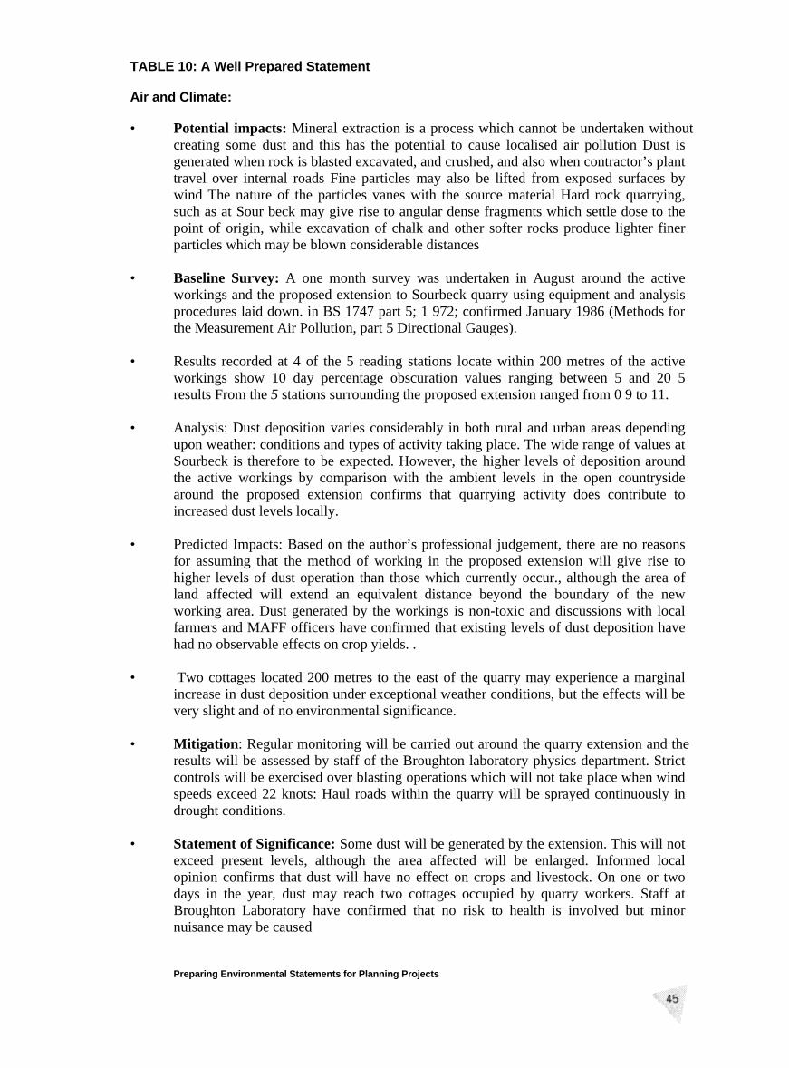
TABLE 10: A Well Prepared Statement Air and Climate: • Potential impacts: Mineral extraction is a process which cannot be undertaken without
creating some dust and this has the potential to cause localised air pollution Dust is generated when rock is blasted excavated, and crushed, and also when contractor’s plant travel over internal roads Fine particles may also be lifted from exposed surfaces by wind The nature of the particles vanes with the source material Hard rock quarrying, such as at Sour beck may give rise to angular dense fragments which settle dose to the point of origin, while excavation of chalk and other softer rocks produce lighter finer particles which may be blown considerable distances
• Baseline Survey: A one month survey was undertaken in August around the active
workings and the proposed extension to Sourbeck quarry using equipment and analysis procedures laid down. in BS 1747 part 5; 1 972; confirmed January 1986 (Methods for the Measurement Air Pollution, part 5 Directional Gauges).
• Results recorded at 4 of the 5 reading stations locate within 200 metres of the active
workings show 10 day percentage obscuration values ranging between 5 and 20 5 results From the 5 stations surrounding the proposed extension ranged from 0 9 to 11.
• Analysis: Dust deposition varies considerably in both rural and urban areas depending
upon weather: conditions and types of activity taking place. The wide range of values at Sourbeck is therefore to be expected. However, the higher levels of deposition around the active workings by comparison with the ambient levels in the open countryside around the proposed extension confirms that quarrying activity does contribute to increased dust levels locally.
• Predicted Impacts: Based on the author’s professional judgement, there are no reasons
for assuming that the method of working in the proposed extension will give rise to higher levels of dust operation than those which currently occur., although the area of land affected will extend an equivalent distance beyond the boundary of the new working area. Dust generated by the workings is non-toxic and discussions with local farmers and MAFF officers have confirmed that existing levels of dust deposition have had no observable effects on crop yields. .
• Two cottages located 200 metres to the east of the quarry may experience a marginal
increase in dust deposition under exceptional weather conditions, but the effects will be very slight and of no environmental significance.
• Mitigation: Regular monitoring will be carried out around the quarry extension and the
results will be assessed by staff of the Broughton laboratory physics department. Strict controls will be exercised over blasting operations which will not take place when wind speeds exceed 22 knots: Haul roads within the quarry will be sprayed continuously in drought conditions.
• Statement of Significance: Some dust will be generated by the extension. This will not
exceed present levels, although the area affected will be enlarged. Informed local opinion confirms that dust will have no effect on crops and livestock. On one or two days in the year, dust may reach two cottages occupied by quarry workers. Staff at Broughton Laboratory have confirmed that no risk to health is involved but minor nuisance may be caused Preparing Environmental Statements for Planning Projects
7.9 One approachto theevaluationof impactsis to assessthe geographicallevel ofimportanceof the issuesunder considerationin terms of environmentalandplanningpolicy guidelines. For example:
• an impactof internationalimportancewould be onewhich affectsan interestof internationalconcernsuch as a wetlandssite protectedunder the Ramsarconvention,a specialprotectionarea for birds or the dischargeof pollutantsinto the atmosphereor the sea;
• an impact of national importancewould be onewhich affects the nationalinterestas identifiedby Governmentpoliciessuchastheeffectsofadevelopmenton aNationalPark,AONB, SSSIor aGrade1 listedbuilding;
• impacts of regional or county-wide importance would include those wherethescaleofimpactis suchthatit couldsupportor undermineregionalguidanceor StructurePlanpolicy, suchas the erosionof a green belt ordestructionof aRegionally ImportantGeologicalSite;
• impactsof district-wideimportancewill be of relevancewithin thecontextoftheplanningauthority’sadministrativeboundary;and
• impactsof local or localisedimportancewill be thosewhich affect a limitedarea,orare largelycontainedwithin thesite itself, suchasnoise ordustemissions,traffic nuisance,visual impact.
7.10 Having definedthe geographicallevel of importanceof the subjectmatter, it isthenappropriateto considerwhetherthe predictedenvironmentalimpactshaveanysignificanteffects. A distinctionshouldbe madebetweenmajor,minor or nosignificant effects andwhetherthe impactis adverseor beneficial. Significancemayalsobe assessedby examiningthe sensitivityandrarityof the environmentinquestion.
7.11 In addition to commentson importance andsignificanceit is sometimeshelpfulto describethe natureof impacts in more detail. As well as being adverse orbeneficial, they mayalso be categorisedas short or long term, permanentortemporary,irreversibleor reversible,anddirect or indirect.
7.12 It is alsoimportantwhen describingpotentialor predictedimpactsto distinguishbetweeneventswhich are unavoidableandthosewhich areuncertain,includingthosewhich areunlikely to happen.Informationaboutthe level of confidenceina givenpredictionshouldbe includedin the ES.
7.13 It maybe helpful for thepurposeof the non-technicalsummary(seeparagraph4.21) to provide an overall summarytable which records therelativeweightsattachedto the significance ofindividual impacts; an exampleisgiven inFigure2.
Preparing Environmental Statements for Pianning Projects
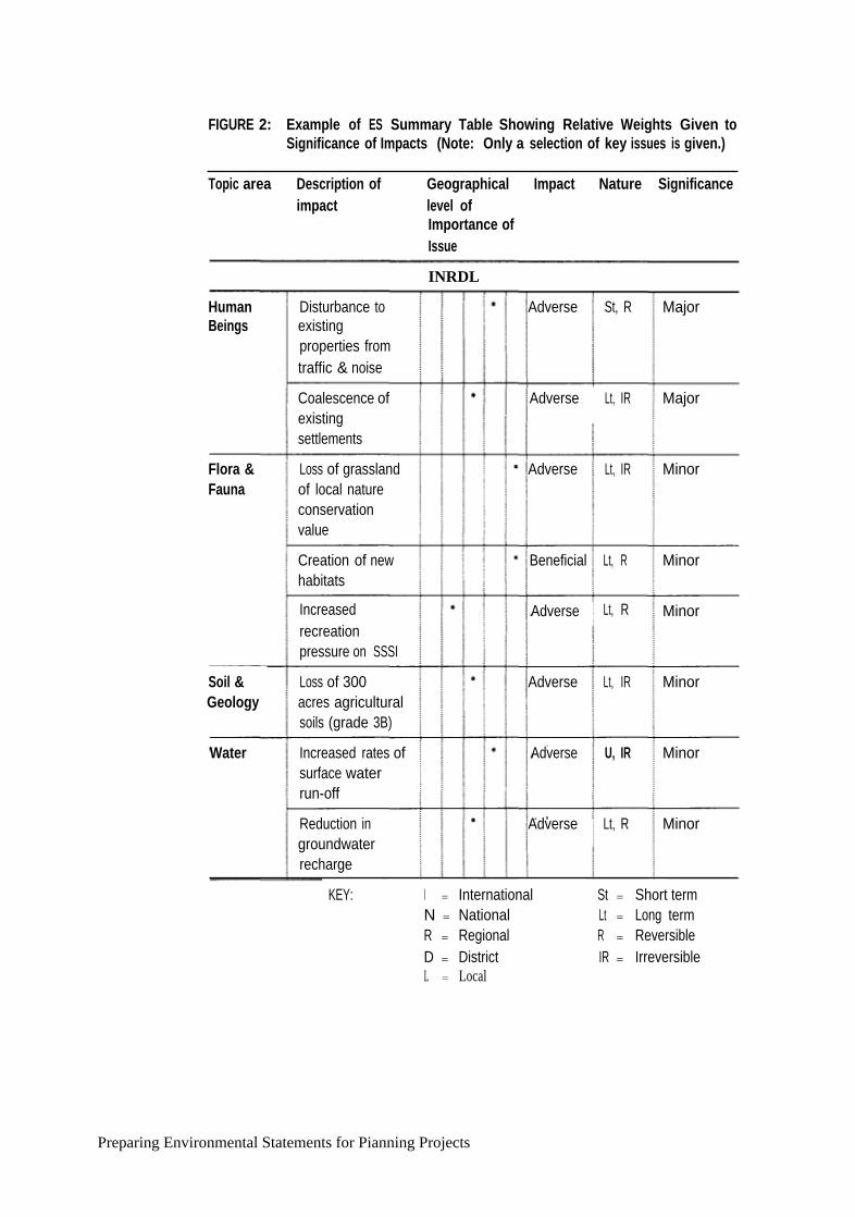
FIGURE 2: Example of ES Summary Table Showing Relative Weights Given toSignificance of Impacts (Note: Only a selection of key issues is given.)
Topic area Description of Geographical Impact Nature Significanceimpact level of
Importance ofIssue
Creation of newhabitats
Increasedrecreationpressure on SSSI
Loss of 300acres agriculturalsoils (grade 3B)
Increased rates ofsurface waterrun-off
Reduction ingroundwaterrecharge
HumanBeings
INRDL
Disturbance toexistingproperties fromtraffic & noise
Adverse St, R Major
Coalescence ofexistingsettlements
Adverse
Flora &Fauna
Lt, IR Major
Loss of grasslandof local natureconservationvalue
Adverse Lt, IR Minor
Beneficial Lt, R Minor
Adverse
Soil &Geology
Lt, R Minor
Water
Adverse Lt, IR Minor
Adverse U, IR Minor
Adverse Lt, R Minor
KEY: I = International St = Short termN = National Lt = Long termR = Regional R = ReversibleD = District IR = IrreversibleL = Local
Preparing Environmental Statements for Pianning Projects

MITIGATION OF ADVERSE EFFECTS
7.14 The ESshouldincludea sectionoutlining opportunitiesfor reducing identifiednegativeenvironmentalimpactsby mitigatingor compensatingfor adverseeffects,or by enhancingbeneficial aspectsof the development.
7.15 Mitigation measuresshouldbeidentified, indicatingthedeveloper’scommitmentto their implementationtogetherwith any furtherimpactsthat theymaycreate.Althoughit is not alegalrequirement,thedevelopermayfind it helpful to explainany non-mitigationof a predictedadverseimpact. The ES should alsodescribethe nature,extentandlocationof anycompensationor enhancementmeasureswhich would result inenvironmental improvementsnot necessarilyrelatedto aspecificallyidentified environmentalimpact.
7.16 The scopefor improving the qualityof thedevelopmentand reducingpotentialadverse effectson theenvironmentduringthe design processis oneof the benefitsof EA. However, themitigating measuresmay themselvessometimeshavepotentiallyadverseaspectswhichshouldalsobe recognised. For example,earth-mouldingto providenoise baffles or screening cancreateunnaturallandformswhich can be visually intrusive.New habitatsor openareasto compensatefordamageto existingplantsor recreationareasalso needto beassessedin their ownright for example,tree screeningcould disturbothernaturalhabitats.
Preparing Environmental Statements for Planning Projects

APPENDICES
Preparing Environmentai Statements for Planning Projects

Preparing Environmental Statements for Planning Projects
APPENDIX
HUMAN BEINGS
1. The way impactsof a projecton the physicalenvironmentaffect humanbeingsneeds to be described inEnvironmentalStatementsandthis appendixdealswithconcernsrelatingto population, and housing andservices.
2. In practice,the assessmentof the potentialimpactsof aprojecton humanbeingsrepresents adistillation of many of the topics covered inothersectionsof anEnvironmentalAssessment. Forinstance,the full analysisof air pollution willneedto considerthe implicationsfor humanhealthandwelfare, as will a fullanalysisof water quality. The section onhumanbeings should, therefore,becross-referencedwith thoseimpactsidentified in othertopic areaswhich appearlikely to have animpacton humanwell-being. It may also needto consider,ifrelevant to the developmentin question, topics such as the environmentalconsequencesofchanges inpopulation, housing andservices,or theimplicationsof noiseand traffic on humanwell-being.
3. The scopingprocessshould considerwhich environmentaleffects, if any, arelikely to affecthumanbeings. It should considerthe rangeof subjectmatterandthe level ofinvestigationrequiredkeepinga balancebetweenbroadgeneralisationsandfine definitions. Table 11 overleafsummarisespossibleimpacts onhumans.
POPULATION
4. Many developmentproposalswill have little or noimpactson population. Animpactis mostlikely to occurwhere majordevelopmentis proposedin arelativelyremote and lightly populatedarea. In such casesbenefit may flow from thestemmingofoutwardmigrationandthesupportof thelocal economyandservices.However,inwardmigration maylead to conflictsof interest betweenthe incomersandestablishedresidentpopulationor whereanew developmentrequiresskillsnot locally available,leadingto amigrationinwardsof suitablyskilledstaff.
5. Potentialimpacts: In afewmajorcases,for exampletheconstructionofareservoir,the proposalmayinvolve theinvoluntaryrelocationofcommunitiesor individualhouseholds.More often, amajor developmentwill result in the movementofpeoplethroughchoice.Two factorsinfluencethe significanceof the effects. The
Preparing Environmental Statements for Planning Projects

first is the relativescaleof migrationin relationto existingpopulationlevels; thesecondis thetimescale overwhich it takes place.
6. At its mostbasiclevel, arapid increasein populationmayoverloadthecapacityof existingservices (water,gas, electricity and sewerage),and transportandeducationfacilities, aswell asincreasepressureson housingstockandthe demandfor land.
TABLE 11: Possible Impacts on Human Beings Relating to Population, Housing andServices
If existing housing stock is underused, sparecapacity is taken up. If fully used, the pressuremay lead to problems of overcrowding, longdistance commuting etc and to a demand for newdwellings. This may require additional landallocations.
Preparing Environmental Statements for Planning Projects
Effect on Humans
• Population:
Potential Environment Effect
Changes in Populationstructure
Increase in inward migration
Changes in demand for housing, services andrecreation facilities
Increase in outwardmigration
Increases in demand for housing, services andrecreation facilities
• Housing:
Possible changes in use and management of ruralareas, increases in numbers of redundantbuildings, possible declining environmental quali
Requirement for temporaryaccommodation duringconstruction
Raises issues of location, design and siting.
Increase in demand forpermanent housing
• Services:
Increase in demand forhospitals, schools, shopsrecreation facilities etc.
Any surplus is taken up. Where there is nosurplus, difficulties of overcrowding of existingfacilities and reduced standards in services (forinstance a fall in river waterquality as aconsequence of increases in foul water drainage)will lead to a demand For extra provision. This inturn may require additional land allocations.Increasing demands placed on infrastructure andutilities.
7. BaselineSurveys: Inorder to assesspopulationimpacts,baselineinformationshould describethe characteristicsof the local populationin terms of age, sexandmaritalstatus. Wheresignificantmigration inwardsis anticipated,dataonhousingprovision, schools, hospitals etc.andtheir usemay needto be collected.
8. An indication of the extentof migration to the areaarounda proposedmajordevelopmentmaybe gainedby consideringthe proportionof new jobs(includingthose insuppliersetc.) which will be filled by local peopleand theproportionwhichmust be madeup from outsidethe area.
9. The timingandnatureof the immigrationwill beimportant. The initial roundof migrationwill be associatedwith the constructionphaseof a development,andmaycompriseahighproportionofyoung,singlemaleswhomakerelativelylight demandson education,healthor recreationfacilities, andmaybehousedintemporaryaccommodationon or nearsite. This migrationwill be of a shortterm nature. A secondphaseof migration comprisingthose peopledirectlyemployedin thedevelopment maytake placewhenthe development’sfinal usecommences,and is likely to include a higher proportionof family groups. Athird phaseof migrationis lesswell definedandis harderto predict,comprisingpeoplewho are moving to find work in the ancillary industriesand expandinglocal companieswhich are supportedby the newdevelopment.
10. Determining magnitude and significance: comparison ofthe employment createdby a proposeddevelopmentwith the characteristicsof the local labourmarketshouldhaveestablishedwhethermigration inwardsis likely to occur. An age-sex-maritalanalysisofexpectedmigrantswill give anestimateof thelikely demandfor housing,educational, healthand recreationalprovision. Comparisonwithexisting and plannedprovision will indicate the likelihood of significantenvironmentaleffects.
11. Any significantsocio-economicdifferencesbetweenthe existingandmigratingpopulationsshouldbe noted,since such differences result inimpactson thelocalculture (for examplethe influx of non-Welshspeakersinto a Welshspeakingrural area).
12. Sourcesof Information: Analysisofthelikely impactofaproposeddevelopmenton populationwill require demographicinformation for the areaconcerned.Censusdatamaybeobtainedfrom the Officeof Population and CensusSurveys,althoughthelocalauthority maywell havea rangeofmore up-todateanddetailedinformation.
13. Thereareno specificguidelines forassessingthe effectsof majordevelopmentonpopulation,although therearestandardprocedures,includingshift/shareanalysis,for examiningpopulationtrendsandprojecting futurechange.Thesestatisticalanddemographictechniquesareemployed intheestimationoffuturepopulationlevels for local authorityplans. Detailedstudiesof populationtrendsare only
Preparing Environmental Statements for Planning Projects
likely to be requiredfor very largeprojectswherespecialist adviceshould beobtained.
HOUSING AND SERVICES
14. The demand fornew housing andadditionalservicesmay be asubsidiaryissueto majordevelopmentproposals.Wherethescaleof suchancillarydevelopmentcan easily beabsorbedwithin the existinghousingstructure,or imposes nosignificant increasedloadson existingservices,it would be sufficientto notethisbriefly in the ES.Theremay, however,becircumstancesin whichnewhousingandessentialservicesare themselveslikely to createsignificant impactson theenvironment,in whichcaseafull assessmentof the implicationswill berequired.At the otherextreme, thetakingup ofvacanthousing andthesupportof under-used localservicescan be a positive benefit.
15. PotentialImpacts: Where the scaleof housingdemandis likely to exceedthecapacityof the existinghousingstock orallocatedreservesof land, considerationshould be given, as part of the developmentproposal,to ways of resolvingthepotentialdifficulties whichmightotherwiseoccur. Theliving environmentcreatedfor new residentsand theeffects whichnew communities mayhave onexistingsettlementsshould also be considered.Services,including public utilities andtransport,mayhave amajor role to play in supportingnew developmentandshould not be overlooked.
16. BaselineSurveys:Demandfor housing andserviceslikely to begeneratedby theproposeddevelopment,will needto be identified andcomparedwith data onthe rangeandtypeof propertyanddevelopmentlandavailablewithin theprojectarea. Populationstatistics,informationon trendsin the size of householdunitsandothersocio-economicindicatorsmayalsoneedto beconsulted.
17. Prediction and Mitigation of Impacts: The primarypurpose in assessingdemandfor housingandservicesis to ensurethat the newdevelopmentcan beassimilatedinto the areawith maximum benefit to the existingcommunityandminimaladverseimpact. It shouldbe donein wayswhich optimisethe environmentalquality of anynew orexpandedsettlement.It is primarily the consequencesofrapid or unplannedchangewhich have directandadverseimpacts onhumanbeings.
18. Employment: Creationof substantialnewemployment maybe thecatalystforchanges inpopulation andhousing,and the demandfor servicesand naturalresources,with consequenteffectson thephysicalenvironment.Analysisof theexistingemployment structureandlocal economy maythereforebe appropriatein providingbackgroundinformationfor the ES.
19. Sourcesof Information: Information on existinghousingstockand futurebuildingprogrammeswill usually beavailablefrom thelocal authority planning
Preparing Environmental Statements for Planning Projects

and housingdepartments,aswell asfrom housingassociations,estate agentsandothers.The particularneeds forservicesshouldbeknownto the local authorityandutility undertakers.
Preparing Environmental Statements for Planning Projects

Preparing Environmental Statements for Planning Projects

APPENDIX
NOISE AND VIBRATION
1. Noise can have asignificanteffecton the environmentandon thequality oflifeenjoyedby individualsandcommunities.
2. Determining thelikely impactof noise resultingfrom developmentis complexand requires specialistskills. The natureof the subject is such that thereis nopreciselycorrectwayof approachingtheassessmentprocedure,andthe guidelinesandstandardsusedin theassessmentwill varyfrom projectto project. Itis stronglyrecommendedthereforethat thenoiseimpactassessment,wherethisis necessary,is carriedout by staffor agencieswith the expertise tomeasureand predictnoiseandinterpret the data.This appendixoffers only a broadoutlineof the issuesinvolved.
3. Noise hasbeendefinedas ’sound which is undesiredby the recipient’. Theperceptionof noisemaybe reflectedby manyfactors(acousticandnon-acoustic)but in generalthe impactin response to anoisedependson thelevel of noise,themargin by which it exceedsthe backgroundlevel, its spectralcharacter,andtemporal variation.In somecasesotherfactors suchas the timeof day,dayof theweek, duration,andotheracoustic features suchas tonality andimpulsivenesswill be important.Any assessmentof noise must takeaccountnot only of thelevel of noisebut alsoof theseotherfactors.
4. Vibrations, even very lowmagnitude,may be perceptibleto peopleand caninterferewith thesatisfactoryconductofcertainactivities, egdelicateproceduresin hospitaloperatingtheatres,useof very sensitivelaboratoryequipmentetc.Vibration nuisanceis frequentlyassociatedwith theassumptionthatif vibrationcan be felt, thendamageis inevitable.However, considerably greaterlevels ofvibration are requiredto causedamage tobuilding structures(seefor exampleBritish StandardBS 7385) or to causecomputersandother similar electronicequipmentto malfunction.
POTENTIAL IMPACTS
5. Therearemany effectscaused by noise.It can causeannoyance,interferewithcommunication,cause fatigue,increaseheartrate, reducesleepquality andsenseof well-being. In somecasesit can lead to loss of amenity.
Preparing Environmental Statements for Planning Projects
6. Noisy development mayalso have aneffect on the welfareof livestock andonwildlife. For information of the effects on livestock, developersshouldcontactthe Ministry of AgricultureFisheriesandFood(Land Use PlanningUnit).
Potential sources of noise and vibration
7. Thereare four maintypes of noisepollution:
• Industrial noise: includes factories, industrial plant, manufacturing,infrastructureprojects,industrialsourcesin commercialpremises,construction,quarries etc.
• Transportation noise: includes that from road traffic, railways, aircraft andwaterbornecraft;
• Leisurenoise: includesthatfrom motorsports,sportingevents,leisurecentres,pubsetc; and,
• Domestic noise: includes music, intruder alarms and parties. In general itwill not be necessaryto include this type of noise in an environmentalassessment.
8. Potentialsourcesof vibration include blastingin quarries, mines,constructionor demolition, piling in construction, dynamicsoil compaction,rail and roadtraffic, andheavymachinery.
9. Vibrations transmittedfrom site activities tothe neighbourhoodmaythereforecause anxietyaswell as annoyance,candisturbsleep,work or leisure activities.As with noise, inany neighbourhoodsomeindividualswill be more sensitivethanothers.
10. Damageto buildings arisingfrom vibration maybe classifiedas
• Cosmetic:theformationof hairlinecrackson drywall surfaces, orthegrowthof existingcracksin plaster or drywallsurfaces;
• Minor: the formation of large cracks or looseningand falling of plaster ordrywall surfaces, orcracksthroughbricks/concreteblocks;
• Major: damage tostructuralelementsof the building, cracks in supportcolumns,looseningof joints, splayingof masonrycracksetc.
PREDICTION AND MEASUREMENT OF NOISE
11. Thehumanear detectssound whichlies in the 20 to 16,000Hertz (Hz) frequencyrange. However, sensitivity is greatestwithin the 500 - 5000 Hz range.This
Preparing Environmental Statements for Planning Projects
characteristicis reflected in the waysound is measuredand also suggeststhatattentionis paidto sourcesof noisewhich lie within theseranges.
12. Soundcan be measured either in termsof its generationor in termsofits reception.The formermeasuresin termsofenergyneeded to generateit; the lattermeasuresthe pressurethat is exerted on amembraneby the soundwaves, expressedassoundpressurelevels.This is the more commonlyused measure.
13. Thebasicunit used innoisemeasurementis the decibel (dB).This is an objectivemeasureof soundpressureanddoesnot thereforemeasure loudnessas sensedbythe humanear.To takeaccountofthis, the decibelmeasureis correctedby the‘A’weighting factor. The resultantunit of loudnessis termeddB(A).
14. Various noisemeasurementindices exist to describe noise sourceswith differingcharacteristics. The LA90,T index indicates dB(A) levels that are exceeded for 90%of the specifiedmeasurementtime period. This is currently used in themeasurement of background noise (see BS 4142). LA10,T represents noise levelsexceededfor 10% of a giventime interval.This is used in themeasurementofroadtraffic noise. Analternativemeasureis L which representsthe average
AeqT
continuoussoundlevel over aperiodof time. This is the principal measurementindex for environmentalnoise(seeBS 7445, ISO 1996).
Vibration
15. In general,building vibrationshouldbe measuredin accelerationterms. In somecases,suchasimpulsive events,it maybefound convenientto measurein termsofparticlevelocity sothatpeakvaluesmaybeidentified.Thepeakparticlevelocity(ppv) is the simplestindicatorof both perceptibilityandthe risk 0f damagetostructures.Thevibrationdose valueis recommendedin BritishStandardBS 6472as theappropriatemeasureof nuisancefrom vibration.
16. Peakparticlevelocity is the instantaneousmaximum velocity reached bythevibrating elementsas it oscillatesabout its rest position. In order to obtain atypical valueof ppv it will be necessary tomonitor a representativenumberofcyclesof operation.
NOISE STANDARDS AND REGULATIONS
17. PlanningPolicy GuidanceNote PPG24, PlanningandNoise, offers advice onhow the planningsystemcan be used tominimise the adverseimpactof noisewithout placingunreasonablerestrictionson developmentor addingundulytothe costsandadministrativeburdenson developers.The guidanceoutlinestheconsiderationsto be takeninto accountin determiningplanningapplicationsfor developmentswhich will generatenoise and also for noise sensitivedevelopments.The following paragraphs,which deal with someprojectareaswhich commonlyattractenvironmentalassessment,summariseguidancerelating
Preparing Environmental Statements for Planning Projects

to the assessmentof noisefrom differentsourcespublishedin PPG24.
Noise from industrial and commercial developments
18. The likelihood of complaints aboutnoise from industrial developmentcan beassessed,wheretheStandardis relevant,usingguidancein BS4142:1990.Tonalor impulsive characteristicsof the noise are likely to increasethe scopeforcomplaintsand thisis takeninto accountby the “rating level” defined in BS4142. This rating level is usedby the planning authoritywhenstipulatingthelevelof noisethatcanbe permitted. Thelikelihoodof complaintsis indicatedbythe differencebetweenthenoisefrom the newdevelopment(expressedin termsof the ratinglevel) andthe existingbackgroundnoise.The standardstatesthatadifferenceof 10dB orhigher indicatesthatcomplaintsare likely. A differenceofaround5dB is of marginalsignificance.
19. Since backgroundnoise levels vary throughouta 24 hour period, it will benecessary toassessthe acceptabilityof noiselevels for separateperiods(day andnight) chosento matchthe hoursof operationof the proposeddevelopment.Generalguidanceon noiselevelswithin buildingsis to befoundin BS 8233:1987.Guidanceon thecontrol of noisefrom surfacemineralworkingscan befound inMPG11.
Noise from Construction sites
20. Guidanceon assessingnoise from constructionsitesmay be found in BritishStandardBS 5228,parts 1 -4. In particularPart 1:1984, “Code of Practiceforbasicinformation andproceduresfor noisecontrol” shouldbe useful;aswell asproviding generalinformation it describes amethodfor predictingnoisefromconstructionsites.
Noise from Landfill Waste Disposal Sites
21. The main sourceof noise on thesesites is from vehicle movements,tippingoperationsandsiteplant.Useful informationofpredictingthe noisecan befoundin BS 5228 :part1:1984. Conditionsattachedto wastedisposalinstallationsbyplanningauthoritiesgenerallyplacelimits on theamountof waste,frequencyofdeliveriesandhoursof operation.Thesewill have aneffect of the amountofnoise generatedbut site licenceconditionscan also relate tonoise controlspecifically.
Noise from road, rail and air traffic
22. Someguidanceand informationabouta meansof calculatingnoise resultingfrom road trafficis availablein theCalculationof RoadTraffic Noise(DepartmentofTransport/WelshOffice, 1988),andtheMemorandumon the NoiseInsulation(Scotland) Regulations1975. Adviceand informationis alsoavailablein “Design
Preparing Environmental Statements for Planning Projects

Manual for Roadsand Bridges” Vol 11, section3, part 7 -traffic noise andvibration.TheDepartmentofTransporthasrecentlyproducedsimilarguidanceon thecalculationof noisefrom railways,Calculationof RailwayNoise 1995.
23. TheDepartmentofTransportexpressesaircraftnoiseexposurecontoursin termsof Leq dB(A) overtheperiod07.00 hoursto 23.00hours.This indexis equivalentto an LAcq16h dB. Using forecastcontours,it should be possible todetermineapproximatelywhich areasarelikely to fall within the differentnoise categoriesdescribed in PPG24. Technical advice ontheproductionof noisecontourscanbeobtained fromtheDepartmentofSafety,EnvironmentandEngineering,CivilAviation Authority, 45-49Kingsway,Holborn, London WC2B6TE.
Vibration
24. British StandardBS 6472 offers guidanceon the evaluationof humanexposureto vibration in buildingsandBritishStandardBS 7385 coversthemeasurementandevaluationof vibration in buildingsanddamagelevels from ground bornevibration.
ASSESSMENT OF NOISE AND VIBRATION
Noise
25. A numberofassessmentlocationswill need to beidentified for eachproject.Theactualnumberof identifiedassessmentlocationswill varyfrom projectto projectdependingon factorssuchasthepredictedlevel ofintrudingnoise,likely variationsin thelevel of intruding noise,local topographyand local climatic conditions.The distribution of the assessmentlocationsshould cover all noise sensitivepremises.
26. Noise sensitivepremisesinclude anyoccupiedpremisesused as a dwelling(includinggardens),educationalestablishmentorhospital.Specialconsiderationshouldalsobe given todevelopmentwhich wouldaffect the quiet enjoymentofNationalParks, the Broads,AONB or HeritageCoasts.
27. At eachof the identified assessmentlocationsboth the existingnoiselevelsandthe predictednoiselevels occurringas resultof the developmentwill have to bedetermined. Theselevels maybe obtainedby measurementand/orcalculation.
Vibration
28. Similarly, a numberof vibrationassessmentlocationswill needto beidentifiedfor eachproject(thesemaywell bedifferentfrom the noiselocation).The numberof locationswill vary fromprojectto projectdependingupon factors suchas theproposedsourceanddistancefrom otherdevelopment,topographyandgeologyThepredictedimpactvibration levelsmayin somecircumstancesbeobtainedby
Preparing Environmental Statements for Planning Projects

a numberof small test explosionsor vibrations designedto replicate thecharacteristicof the vibrationemanatingfrom thedevelopment.
29. Scoping: Closeexaminationof the project proposalmustidentify all significantactual andpotentialsourcesof noise andvibrationsuch as local industrial andtransportationsources.
30. Scopingshould also identify the likely recipientsof anynoise impacts. Theseshould includenoise sensitivepremises.The identification of thesepotentialrecipientswill help focus thebaselinesurvey to those nose sensitivelocationswhereimpactsare likely to bemostsignificant.
31. BaselineSurveys: The baselinesurveyshouldbe tailoredto reflect the typesofnoiseandvibration impactsidentifiedby thescopingprocess.
32. Predictionof Impacts:The prediction(which mayin certaincircumstancesbebasedon actualmeasurement)of likely noiseandvibration impactsshouldbuildupon thework undertakenduringthe scopingandbaselinestagesof assessment.The projectmayrequire separatepredictionsfor its variousconstituentphases.Thesemay include, for example,site reclamation,construction,use anddecommissioning.
33. Determiningthesignificanceof impacts: Whenplacing a value on thepredictedimpacts,the environmentalassessmentstudywill have to rate the significanceofthe impactsin termsof factors suchas the numberofpeopleaffected,magnitudeof impact andtime scaleof impact.
34. Mitigation of impacts: Where impactsareconsideredsignificant, measurescanbe introducedcontrol the sourceof, or reduceexposureto, noiseandvibration.Examplesof mitigation measuresinclude:
• Design/engineering:reducingnoise at sourceby, for example,usingquietermachines;use of acousticenclosures,improving the sound insulationandvibration isolation
• Lay-out: ensuringan adequatedistance betweenthe point of sourceandrecipient;makinguseof naturalcontoursandbarriers;and
• Administrative: limiting operating timeof the sourceof noise.
Preparing Environmental Statements for Planning Projects

Selected Sources of Further Information
• British Standard5228: 1984 (parts 1-3), 1992(part 4), Noise control onconstructionandopensites
• British Standard5821: 1984,Ratingthe sound insulationin buildingsandofbuildingelements
• BritishStandard8233: 1987,Soundinsulationandnoisereductionfor buildings.
• BritishStandard4142: 1990,Methodfor rating industrialnoise affectingmixedresidentialandindustrialareas.
• British Standard7445: 1991,Descriptionandmeasurementof environmentalnoise.
• British Standard 6472: 1992,Guideto evaluationofhumanexposure tovibrationin buildings (1Hzto 80Hz)
• DoE Circular 11/95 - The Use ofConditionsin PlanningPermissions(1995)
• Mineral PlanningGuidanceNote 11 - TheControl of Noiseat SurfaceMineralWorkings (1993) - HMSO
• PlanningPolicy Guidance Note15 - Planningand the Historic Environment(1994) - HMSO
• PlanningPolicy Guidance Note17 - SportandRecreation(1991) - HMSO
• PlanningPolicy GuidanceNote 23 - PlanningandPollution Control (1994) -
HMSO
• PlanningPolicy GuidanceNote 24 - PlanningandNoise (1994) HMSO
• Report of Noise Review Working Party, 1990 (HMSO) (ISBN 0 11 752343 7)
Preparing Environmental Statements for Planning Projects

Preparing Environmental Statements for Planning Projects
APPENDIX
TRAFFIC AND TRANSPORT
1. This appendixis concernedspecificallywith theenvironmentalimpactsof trafficassociatedwith new developmentsrather thanwith the impactsof new roadconstructionanduseof new roads.It is unlikely that the entire rangeofimpactsdiscussedbelow would occur exceptin the caseof the largest developmentproposals.
POTENTIAL IMPACTS
2. Traffic associatedwith a newdevelopmentcan have awide rangeofoftenadverseenvironmentaleffects. These vary intheirextentandsignificanceaccordingtothe type,locationandsize of the developmentin question,andthe compositionof associatedtraffic. The impactsmay also vary during constructionandoperationalphasesand this shouldbe reflected inthe ES.
3. Increasesin traffic flows canlead toincreasesin noiseandvibration in thevicinityof existingor new roads(asdiscussed inAppendix2).
4. An areaof continuedandgrowingconcernis the airpollution causedby traffic.(SeealsoAppendix8). Any increasein traffic flows in thevicinity ofadevelopmentwill lead to increasesin localconcentrationsofpollutantssuchas carbonmonoxide,sulphurdioxide,oxidesofnitrogen,particulatesandlead. Thelevel ofair pollutionis influencedby traffic flow, vehicle speed, vehicletypeandengineefficiency. Airpollutionfrom vehiclesmaybe particularlyimportantwhere roadspassthrough,or close toresidentialareas,schools or recreationareas,or from the stop-startcharacteristicsof traffic at junctions. If the additional trafficgeneratedby adevelopmenttakes trafficflows beyondthe capacityof the local road network,the resultingcongestionmaylead to adisproportionatelocal increasein pollution.Otherairbornepollutantsincludedustand dirt depositedalongsideroadsandcarbondioxidewhichcausesenhancedglobalwarming(traffic accountsfor 19%of UK carbondioxide emissions).
5. Traffic mayalsoconstituteavisual impact,particularlywhereheavygoodsvehiclesare present,or whereincreased trafficflows are introduced intoan areaof highlandscape or townscapevalue. Increased vehicleflows or vehiclespeedscan result
Preparing Envkonmentat Statements for P’anning Projects

in an increase in pedestrian delay, making crossing difficult. Similarly, increasesin vehicle trafficflow mayresult in anincreasein dangerto pedestrians,cyclistsandmotorists.Suchdelaysandincreasedlevel ofrisk cancontributeto anincreasein severance,i.e. thesuppressionor diversionof trips.
TRAVEL AND TRAFFIC
6. In assessingtheimpact of new developments, consideration shouldbe given tothe impactof travel likely to begenerated.This includesboth theeffectsof thewholejourney(including the frequency,length, timing andmodeof travel) andtheimpacton thelocal transportnetworkatcritical times.Thevolumeandtypeof traffic generatedby a new developmentis a functionof its accessibility. Thisin turn is determinedby its location, natureandsize.
7. The Government’spolicy on transportand planning in England is set out inPlanningPolicy Guidance Note13 - ‘Transport’. This adviseslocal authoritiesto implementpoliciesandproposals in theirdevelopmentplanswhichwill reducethe needto travel, reduce reliance on the private carandencourageothermeansof travelwhichhavelessenvironmentalimpact. Plansshouldguidedevelopmentto locationswherethe travel generatedwill be minimised. Plansshould alsoincludecomplementarypoliciessettingout proposals fortrafficcalming,reducedcarparkingrequirementsandbetterfacilities for pedestriansandcyclists.
8. The accessabilityof any given developmentwill be largely determinedby itslocation. If a developmentis not easilyaccessibleby walking, cycling orpublictransport,thena largeproportionof trips to and from the sitewill be madebycar. Similarly, freight movementswill be mostly by road unless thereis easyaccessfrom thesite to the railand/orwaterwaynetwork. Wherefreight has to bemovedby road in significant quantities,lorry vehiclemovementswill have animpact unless thedevelopmentis located within easyaccessto the trunk roadnetwork.
9. The natureof the developmentis also important. For example,warehousingandsometypesof manufacturinggenerallydo not attractmanyjourneysby carbutwill involve quitehighfreight movement. On the otherhand,offices,shopsandleisuredevelopmentsattract many individualvisitors but have relatively lowfreight requirements.The timeof traffic movementsmayalsobe aconsideration.Night timejourneysmaybe moresignificantthanasimilar traffic flow earlier inthe day.
10. The compositionof large-scaledevelopmentalso influencestraffic generation.Single-usedevelopment,suchas employmentor recreationfacilities, is likely toinducedistinct peaksof traffic flow. Mixed-use schemesmayreducetraffic aspeople canuse thesamejourneyfor severaldifferent purposes.Further,mixed-usedevelopmentcan help spreadtrips more evenly throughoutthe day, thusreducing peakflows during morningand eveningrushhours whenadverse
Preparing Environmental Statements for Planning Projects

conditionson thelocal roadandpublictransportnetworksare likely to bemostsignificant.
MEASURING AND PREDICTING TRAFFIC FLOWS
Measurement
11. An assessmentof traffic impactsrequires adescriptionof the currenttransportnetworkand anyforeseeablechanges.The local authoritymayhold extensivedatadescribingexisting trafficpatterns.Thiscouldhelpdeterminewhethertrafficlevelsvaryby time of year, or whetherrecognisabletrendsin traffic flows exist.The reviewof existingtraffic datawill identify areaswherefurther measurementor estimationis required,perhapsof totalor classifiedvehiclecountson sectionsof roads or atjunctions,andto differentiatebetweendifferent timesof dayetc.
Predicting traffic associated with new developments
12. Predictionof futuretraffic flows comprises two main elements:thecalculationoftrip generation,andthe assignmentof this traffic betweendifferent routes.
13. Typical trip generationforecastsarestatisticallyderivedfrom characteristicssuchassize,numberof employees,locationand type. Varioustechnicalguidesexistto assistwith thesecalculations(for example,informationmaybe found in theInstituteofHighwaysandTransportationguidelinesfor Traffic ImpactAssessment1994, the Departmentof Transport’sTraffic AppraisalManual (TAM) andNational Road Traffic Forecasts(NRTF) and the Scottish DevelopmentDepartment’sreport Traffic Impact of Developmentsin Scotland 1989). Inaddition,a numberof databasescontain trip generationinformationfor a rangeof actualdevelopments,for example theTRICS database, developedby countyauthoritiesin the SouthEast. The methodused in the calculationsshouldbeoutlined in theES.
14. The assignmentof the predictedtraffic betweenroutesin the areais calculatedwith reference to thelikely origins anddestinationsof employees, visitorsandgoodsvehicles,togetherwith theknowncharacteristicsof the local road networkand anyforeseeablechanges. Itis commonpracticeto predictwhat will be theimpactsof the developmentin its openingyear and 15 yearsafter itsopeningyear. The assumptionsnormally requiredby suchcalculationsand themethodusedshouldbe clearly stated.
ASSESSMENT OF THE IMPACT OF TRAFFIC ASSOCIATED WITH A NEWDEVELOPMENT
15. Scoping:The nature,sizeandlocationof adevelopmentproposal,togetherwiththe characteristicsofits surroundings shoulddictatewhethera detailedassessmentof likely traffic impactsis required. The developershouldthereforemakeearlycontactwith the local authorityto try to agree the detailsof the assessment.
Preparing Environmental Statements for Planning Projects

16. For a smalldevelopment,or onewith few employeesandlittle movementof rawmaterialsor goods,it maybe decidedthatthetraffic impactsof the developmentdo not warrantdetailedappraisal. Inthe caseof a largerdevelopment,trafficimpactsmaybeconcentratedin the vicinityofasinglestretchof roador ajunction.Very largedevelopmentsmayrequire amoredetailedapproach,examiningthechanges in vehicleflows on anetworkof roadswithin anareaaroundthe proposeddevelopment,and requiringan assessmentof likely consequencesin termsofnoise, airpollution or othereffects.
17. The scopingprocessshouldidentify the natureandextentof existingtraffic datawhich may be held by the local authority, the Departmentof Transport,theWelsh Office Highways Directorate or the Scottish Office DevelopmentDepartment- NationalRoadsDirectorate.It shouldalsoestablish factorsagainstwhich thesignificanceof changes intraffic flows can beassessed.Thesemayinclude sensitiveland uses suchas hospitals,schools, dwellings,areasof natureconservation/ landscapevalue orrecreationareas.
18. Baseline Surveys: The scopingprocessshould have determinedthe areasofparticularconcern andidentified the extentof existinginformation. The mainfunction of the subsequentbaselinesurveyis to provide a benchmarkagainstwhich theeffectsof the developmentmaybe judged,so account shouldbe takenof any featuresexpectedto affect traffic flows by the time the proposeddevelopmentopens,togetherwith anynew roads,railwaysor otherdevelopmentsthatare proposed.The degreeof certaintyregardingpossiblechangesshould beclearly stated.
19. Prediction of Impacts: The analysisof traffic generationanddistributionshouldindicatethe extentto which existingroutesandjunctionshavethe capacitytoaccommodatethe forecast trafficgrowth, andmayhaveindicatedthe needformanagement methods(suchas traffic signals). During thisanalysis,attentionshouldbe paid bothto the degreeof changeandto the absolutelevelsof traffic.
20. Havingestablishedthe volumeof the flows thatrepresentexistingtraffic togetherwith that from the newdevelopment,andhaving identified areasof particularconcern,the environmentalimpactsof the traffic shouldbe consideredfor thevariousphasesof the development.Thesewill varyaccordingto thelocality, butmay include noise,vibration, local concentrationsof air pollutants,visualintrusion,effectsof dustandsalt spray,roadsafety, severance,traffic congestionandpossibleremedies.They can affect local residents,employees,buildingsandthe naturalenvironment. Anynet increasein traffic will increaseemissionsofcarbondioxide.
21. Mitigation of Impacts: Where the assessment hasindicatedthat significantadverse effectsare likely, a rangeof measuresmaybeemployedto ameliorateormitigate theseimpacts.
Preparing Environmental Statements for Planning Projects
22. The most fundamentalmeansof reducingtraffic impactsassociatedwith aproposeddevelopment includeareductionin sizeor the selectionofan alternativesite wherethe local road network is betterable toaccommodatethe associatedtraffic without adverse effectsor which is betterserved bypublic transport.
23. If it is establishedthata development’s trafficgenerationis associatedwith themovementof employees,visitors and customersto and from the site bycar,alternativemethodsof transport maybe considered.
24. Public transport provision may be improved by negotiating with the relevantoperators. Alternatively, if the developmentis of sufficient size, the developermaybe preparedto operateservices.
25. Cyclingcan beencouragedby a range of positivemeasuressuchasthe provisionof cycle pathsandlanes, secureparking,andareaswherecyclists canshowerandchangeprior to work. Travel to work on foot canbe encouragedby theprovisionofwell designedandsecurefootpathslinking the developmentwithsurroundinghousingor shoppingareas,or with public transportfacilities.
26. Mitigation of specific impacts on roads around a development may be achievedby careful design of site layout, in particular the number and location of accesspoints. It may be possible to reduce likely adverse effects by traffic managementor traffic calmingmeasureson streetsaround the site so that traffic flows arerestrictedto routescapableof accommodating themwithout significantadverseimpacts.But thereare indicationsthat measuressuch as road humpsare lesssuccessfulin reducingnoise from commercialvehicles,especially heavy lorries.The argumentsfor andagainstconcentratingor dispersingtraffic flows will varyaccordingto thedevelopmentandits location.
27. If traffic noise is consideredto be asignificantadverseeffect of a development,andit cannotbe tackledatsource(bylimiting vehicleflows in particularlocations),noisebarriersor insulationsuchas doubleglazingmaybe appropriate.
28. The impacts associatedwith themovementof heavy goodsvehiclesto andfromasite maybemitigatedby agreeing theroutesusedby suchvehicles,transferringfreight to be carried by rail (or rail and road), water or even pipeline, or byagreeingthatsmallervehicleswill be used.Grantscontinueto be available fromtheDepartmentof TransportandtheWelsh Office to assisttowardsthe capitalcost of constructing rail (or inland waterway) freight facilities where these willresult in thetransferof specific traffic from roadto rail/inland waterwayor theretentionof such trafficby thesetwo modes. Effortsshould also be madetosafeguardexistingrailheadandwharfagefacilities.
Preparing Environmental Statements far Planning Projects
Selected Sources of Further Information
• DesignManual for Roads andBridges: Volume10 : Environmental Assessment- publishedby HMSO
• Design Manual for Roads and Bridges : Volume 11 (Sections 1 and 5) -publishedby HMSO
• Guidelinesfor the EnvironmentalAssessmentof Road Traffic- publishedbythe Instituteof EnvironmentalAssessment
• Guidelineson Traffic Impact Assessment- Institute of Highways andTransportation
• National RoadTraffic Forecasts- publishedby Departmentof Transport
• Policy Planning GuidanceNote 13 (Wales) - Highways considerationinDevelopmentControl (1988) - Welsh Office
• Policy Planning GuidanceNote 13 - Transport - Departmentof theEnvironment(1994)
• Traffic AppraisalManual - publishedby theDepartmentof Transport
• Traffic Impactof Developmentsin Scotland(1989)-ScottishDevelopmentDepartment
Preparing Environmental Statements for Planning Projects
APPENDIX
LAND USE
This Appendix deals with the environmental effects which development can haveon primary land useswhich, broadlyspeaking,does not include the builtenvironment. It doesnot cover theenvironmentaleffectsthat the developmentand intensificationof existingprimary land usesis capableof having on theenvironment.Suchprojectsmay needto besubjected,whereappropriate,to EAin their own right.
TYPES OF LAND USE
2. Many differentusesmay needto beconsideredin relation to different types ofdevelopmentand their settingsand locations, including agriculture, forestry,mineralextraction,waste treatmentanddisposal,andrecreation.Theimpactsofdevelopmentproposalsupon urbanand rural settlementsand their inhabitantsshould alsobe recognised.Manyof theseimpactsare discussedundertheothertopic chaptersin this Guidance. In all casesthe ES should give attention toGovernmentpolicies applicable tothe relevantlanduses,andreferencemadetotheimplicationsof such policies.
Agriculture
3. In ruralareasagricultureis usuallythe predominantlanduseandalthoughtherehavebeensignificantchanges inemphasisin recentyears,the protectionof thebest andmostversatileof agriculturalland, the appearanceof the countryside,and stimulationof the rural economyremainessential.Therewill besignificantoverlapsbetweenthe assessmentof agricultural land useas a topic, and issuesrelating to geologyandsoils, landscapeandnatureconservationbut thesubjectis sufficiently importantto analysein its own right. Studiesshould coverthefour following areas.
4. AgriculturalLandQuality: Agricultural landin EnglandandWalesis classifiedby the Ministry ofAgricultureFisheriesandFoodas the basisoftheAgriculturalLandClassification;in Scotlandby the MacauleyLand Use ResearchInstitute.Maps are availablewhich give a generalindication of land quality in all areas.For adetailedassessmenton an individual landholding, closeinvestigationby asite surveyis required.
Preparing Environmental Statements for Planning Projects

5. The bestquality agriculturallandshouldbe protected from developmentexceptwherethereare no reasonablealternativesiteson land ofa lower quality. Inthecaseof minerals,development mayalsobe acceptable on bestandmostversatileagriculturallandwherelandis capableofbeingrestoredto its originalquality. Insomepoorerareasevennon-primelandmayhavelocal importancefor maintainingviableagriculturein the area.AnyES fordevelopmentaffectingagriculturallandshouldmakereference totheimplicationsofgovernmentpolicy and,wherelandof a high quality is affected, it shouldsetout reasonedargumentsfor thechoiceof the proposed developmentsite, the justification for the proposal,and thereasonfor the rejectionof alternativesites. In the case0f mineralsandwastedevelopment,detailsofsiteworkingandreclamationare requiredto demonstratethe standardof restorationthat is to be achieved. SelectedpublicationsgivinginformationaboutGovernmentpolicies on developmentinvolving agriculturallandaregiven at theendof this appendix.
6. The Rural Economy: Farming is an important industry andthe farmingcommunityhas a vitalrole to play, not only in termsof food productionbut inmanagingandconservingthe countryside.Major developmentsmayadverselyaffect the livelihoodsof thosewho aredirectly involved in working the landbyeither directly displacing individual farms or associatedeffects from adjacentdevelopments.Also, developmentcan have further repercussionson theagricultural economyofthesurroundingareasthrough indirecteffectson markets,and on machineryand feedstuffsuppliers. Where partor the entire farm isrequiredfor development,the assessmentmayneed to examine:
• the typeof farmingsystem;
• thecommercialandtechnical viabilityof theholdingatits existingandreducedsize; and,
• the scope for restructuring the businessthrough land acquisition ordiversification.
7. AccessandSeverance: Developmentin rural areascan result inlandbeingseveredfrom the main body of the farm, adding to operatingcosts and reducing orremoving theeconomicviability ofthe unit. In some partsof thecountry,historicpatternsoftenure,or the need to move stock betweensummerandwinter pastures
hasresultedin a highly fragmentedpatternof landholding. Consequentlytheassessmentshouldtake intoaccountthe effect of the developmenton all aspectsof the farm businessandmayneed to take in amuchlargerlandareathanthatdirectly affected by theproposeddevelopment.
8. Land Drainage: Most farmlandin lowland Britain has been improvedbyunderdrainage. Dislocationof arterial drains,alterationof groundwaterlevelsthroughpumpingandabstraction or the accelerationof surfacewaterrun-off(for example fromroadconstruction),mayall havesignificant effects on land
Preparing Environmental Statements for Planning Projects

drainage. Land drainageand flood defenceimprovementworks which havedeemedplanningpermissionare subject tothe Land Drainage ImprovementWorks (Assessmentof EnvironmentalEffects)Regulations1988’ (asamended).
Forestry
9. Forestsandwoodlandsprovide anumberof environmentalbenefitsincludingalandscape,natureconservationandhumanamenity. Wheredevelopmentthatrequires EAunder the PlanningRegulationsis likely to have a direct effect onareasofwoodlandandforestry, carefulstudyof the existingwoodlandandforeststructurewill be required,covering:
• the typeof treespeciespresent;
• yield classes;
• potentialioss of timberproduction;
• possibleimpactson remainingtrees(throughwindblow);
• effectson future woodlandandforestry management;
• impactson habitats,wildlife andlandscape.
Afforestation itself can sometimeshaveadverseenvironmentaleffects and theassessmentof theseis coveredunderseparate EARegulations.
Mineral Extraction
10. In areaswhereplanningpermissionfor mineral extractionhasbeen granted,orwherepreferredareasofsearchfor mineralshave beenconfirmedin developmentplans,anymajordevelopmentwhich might sterilisemineralsresourcesor haveadverseeffects on future production,shouldbe carefully scrutinised.This willbe necessarynot only wherebuildings andplant are constructedon or abovemineral-bearingland, but wherenew developmentis sitedon a critical accessroute,or toocloseto theextractionandprocessingareato alloweffectiveworkingwithout severeenvironmentalandeconomicdisbenefits.
11. Examplesof the typesof developmentwhich couldgive rise to future problemsfor mineralextractioninclude plants manufacturingfood productsor hygieneandmedicalsupplieswhich requiretobe totallydust-free,and instrumentmakersand othermanufacturingprocesseswith very low toleranceof vibration.Considerationalsoneeds to begiven, in the caseof majorhousingdevelopmentproposals, to thepotentialeffectsofdust, traffic, noiseandvibration from adjacentmineralextractionsites.
1In Scotland the Environmental Assessment (Scotland) Regulations 1988, part v
Preparing Environmental Statements for Planning Projects

Waste Treatment and Disposal
12. The issuesrelevant tomineralextraction applyequally to developmentwhichmaybeproposedin closeproximity to wastetreatmentanddisposalfacilities. Inaddition,where adevelopmentisproposedon ornearasite presentlyor previouslyusedfor landfill purposes,thoroughinvestigationwill be requiredto assessanypotentially adverseeffects arising from ground contamination,differentialsettlementandthe production andmigrationof landfill gases.All thesetechnicalconstraintsare capableof resolutionbut must initially receivethe appropriatelevel of attention. Informationaboutdevelopmenton or aroundlandfill sitesmaybe found in WasteManagementPaper no27, Landfill Gas.
Recreation
13. The potentialeffectsof major developmenton recreationaluseof land, air andwater,varies greatlywith the natureof the development,andthe characteristicsandlocationofthesite. In areaswhich areenvironmentallysensitive,recreationalissuesmaybe oneof the mostsignificantmattersto bedealt within an EA.
14. TheCountrysideCommissionguidancenote‘EnvironmentalAssessment- TheTreatmentof LandscapeandCountrysideRecreationIssues’identifies majorrecreationalresourcesincludingaccessroutes, parks, carparks,commonlandandmanyothers.It proposes asimilarmethodof assessingimpactson recreationtothatset out in this Guide.
ASSESSMENT OF LAND USE
15. Scoping:The scopingstagewill be essential toassesswhich aspectsof primarylanduseareaffectedby thedevelopmentandthelevel ofinformationrequiredtobe collectedduring baselinestudiesto allow a properassessmentof thedevelopmentto beundertaken.
16. BaselineSurveys: Thestartingpoint for adescriptionof howlandis beingusedwill be theland usedesignationscontainedwithin currentdevelopmentplans,including Mineral andWaste Disposal Plans. Discussionswith relevantGovernmentagenciesmayalsobe useful.
17. Additional informationwhich mayberequiredwill dependon the natureof thedevelopmentandprevailinglandusesbut mightinclude,for example:
Agriculture: adescriptionof landquality, land ownershipand tenure,andthenatureof the farmingenterprises.Wherethereare likely to be majorimpactsonagriculture,informationcollectedfrom a deskexerciseanddiscussionswith therelevant organisationsmay needto be supplementedby Agricultural LandClassificationsurvey work. Also, soil samplingandinterviewswith farmersmaybe needed.
Preparing Environmental Statements for Planning Projects

Forestry: a descriptionof plantation types andsizes,yield classesand landownershipand tenure. Wheretherearelikely to be major impactson forestry,discussionsmay needto beheld with the main forestryoperators,aswell as theForestryCommission.
MineralsandWasteTreatmentandDisposal: adescriptionof the currentstatusof activities in the area, i.e. active sitesand their anticipatedlife andafter-use,outstandingpermissionsandnewlygrantedpermissions.Suchinformationcannormallybeobtained fromthemineralplanningandwasteregulationauthorities.
Recreation:adescriptionof currentfacilities for formal andinformal recreationon andsurroundingthe site, including typesof user(eg clubs or generalpublic),levelsofuse,seasonalanddailyvariationsin use. In thecaseofinformal recreation,considerationmayneedto begivento siteswith de factoaccess aswellas designatedareasof openspace. Public rights-of-waywill also needto be addressedfullywheretheyare likely to beaffected. Muchof this informationshouldbeavailablefrom thelocal authorityalthougha surveyof clubsmaybe necessary toassesstheuseof privatefacilities. The useof public rights-of-waycanusuallybe assessedfrom sitevisits combinedwith discussionswith alocal representativeofthe ParishCouncil.
Prediction of Impacts
18. The rangeof impactswhich differenttypesof developmentmighthave on eachlanduse is too diverse to cover here,but in generalmethodsfor predicting theimpactsof developmenton agriculture,forestry,and sites reserved formineralextractionor waste disposal,are based onthe applicationof knowledgefrompreviousresearchandpracticalexperience.Theyare usuallyqualitativein nature.Thereare,however,caseswhere impactsmaybeassessedusingcost-benefitanalysis,particularlyin relationto agriculturaldevelopmentand forestry. Studiesof theimpactofdevelopmenton recreationalsitesandresourcescandrawon a substantialrangeof researchinto visitor attitudesandpreferencesbut anyjudgementaboutthe effectswhich a particular development mayhave onexisting or potentialrecreationalresourcesis likely to be largelysubjective.
Mitigation of Impacts
19. Whereconflictsof interestarisebetweenproposals for newdevelopmentandtheneedto protectmineral resourcesor wastedisposalfacilities, there maybe fewopportunitiesfor introducingmitigating measures.However, it is sometimes
possibleto bring forward the resourcedevelopmentprogrammeto themutualbenefitof both typesof development.For example, sandandgravel,brick clayandopencastcoal reservescansometimesbeextractedin advance of, oras partof, the newdevelopment thusavoidingthe needto sterilise land. In the caseofagriculture,forestryand recreation,thereareoften ways in which the potentialnegativeimpactsof developmentcan bemitigated, including the exchangeofland,plantingofnew woodlands,andprovisionofalternative recreationalfacilities.
Preparing Environmenta’ Statements for Planning Projects

Selected Sources of Further Information
• Circular 18/87 Developmentinvolving Agricultural Land (1987) (Scotland)(Amendedby circular29/88)
• Draft National PlanningPolicy Guideline - Sport and Physical Recreation-
ScottishOffice (1995)
• EnvironmentalAssessment (Afforestation) Regulations1988 (SI 1207)
• EnvironmentalAssessment (Scotland) Regulations1988,partv
• EnvironmentalAssessment- the Treatmentof Landscapeand CountrysideRecreationalIssues- the Countryside Commission
• Guidelinesfor LandscapeandVisualImpactAssessment- the LandscapeInstituteandthe Institute of EnvironmentalAssessment(1995)
• Land DrainageImprovementWorks (Assessmentof EnvironmentalEffects)Regulations1988 (as amended)
• MineralsPlanningGuidanceNotes
• NationalPlanningGuideline- Agricultural Land- ScottishOffice (1987)
• PlanningPolicy Guidance Note7 - the Countrysideand the Rural Economy-
Department of the Environment I Welsh Office (1992)
• PlanningPolicy GuidanceNote 17 - Sport andRecreation- Departmentof theEnvironment/WelshOffice (1991)
• RevisedGuidelinesand Criteriafor Gradingthe Quality ofAgricultural LandinEnglandandWales- MAFF
• WasteManagementPaperNo 27, Landfill Gas - HMSO (1991)
Preparing Environmental Statements for Planning Projects

APPENDIX
FLORA AND FAUNA (ECOLOGY)
The assessmentof ecologicalimpacts’ shouldcoverbothhabitatsandspeciesofflora and fauna (especiallyprotectedspecies)and may needto include bothterrestrialandaquaticecosystemsdependinguponthe natureofthe development.It should includeboth theproposedsite andits surroundings.
2. EAsof planningprojectswill beconcernedprimarilywith terrestrialandfreshwaterecologysincedevelopmentsaffecting the marineenvironmentdo not generallyfall under the control of Town and Country Planninglegislation. However,terrestrialdevelopmentsmayaffect themarineenvironmentfor example,wherepipelines are built to dischargeeffluent to tidal waters.Theremayalso be aneffect on therelationshipbetweenlandandseain termsof barrages,reclamation,marinas andso on.
POTENTIAL IMPACTS
3. Major developmentsmaybesitedacrossdifferenthabitatsofvaryingimportancefor natureconservation,while small developmentsmay be proposedwithin asingleareaof high natureconservationimportance.The aim shouldbe thattheleast sensitiveareaswithin the overall site areidentified for development,unavoidableimpactsminimised, and opportunitiesfor enhancingthe natureconservation interestof thesite maximised.
4. Developmentmay have both direct and indirect impacts onthe naturalenvironment.The mostobviousdirect effect is the physicalremovalof soils andvegetation,and the obliterationor substantialmodificationof existinghabitats.This can be caused by thedevelopmentand its accessroutes.Roadsmayaffectthemovementofwildlife if theycutacrosshabitats,especiallyif traffic is heavy.If populationsof scarcespeciesare separated,their viability and thus survivalmaybe reduced. Habitatsmayalso be threatenedby constructionroutesandworking areas,or by the layingof servicesor pipelines.Potentialindirectimpactsarediscussedbelow.
Throughout the appendix, references to ecological impacts refer to both flora and fauna unless otherwise indicated.
Preparing Environmental Statements for Planning Projects

Pollution
5. It can be verycomplexto tracethepathwaysbywhichpollutantsaffect individualplantsandanimals. Their effect is often cumulativeandcan beinfluencedbyotherenvironmentalfactors suchas temperatureandsunlight.
6. SoilPollution: Pollution of soils canbe causedby substancesdepositedon or inthe land,by polluted precipitation,andby pollutedgroundwater.As in the caseof air pollution,the misplacingofrelativelyharmless materials can have anadverseeffect on local flora. For example, thedepositof nutrient-richmaterials, suchassewagesludge, onnutrient-poorplantcommunitiescanirrevocablychangespeciescomposition. Soil conditionscan alsogreatly alter the effective toxicity ofpollutants.Soil pollution is discussed inAppendix 6.
7. Water Pollution: ChangesinwaterpH, suchas that broughtaboutby introducingwater from one river system toanother,can lead to adverse changes inaquaticspeciescomposition. Also, the accumulationof nutrientsin aquaticsedimentscan causeecologicalchangeswhich are difficult to reverse.Waterpollution isdiscussed inAppendix7
8. Air Pollution: Threetypes of emissionsmay affect the naturalenvironment:chemicalswhich directly or indirectly causedamage;apparentlynon-damagingmaterialswhich can causechemicalchanges (suchas alkalinedust fromcementfactories); andother particulatessuch as dust thrown up along haulagerouteswhichsmothers adjacentplants. Airpollution is discussedin Appendix 8.
Micro-climate
9. Wheredevelopmentis on a sufficiently largescale,or significantheat, lightandradiationemissionsare involved, theambientor background conditionsmaybealtered. Urbanand industrialareas,for example,tendto retainheatandremainathigher temperaturesduring thewinter thanundevelopedrural areas. Thesemicro-climaticchangesmaybe sufficientlygreatto altertheperformanceofsomespeciesof plantsandanimals- althoughthe primaryinfluenceis likely to bethemanmade natureof the urbanenvironmentitself.
10. In the caseof water, the releaseof heat in coolingwater can causesignificantchanges in the receivingwaterbody, especiallywherethis is an enclosedsystem,suchasa reservoiror lake.
Groundwater
11. In addition to potential pollution,developmentcan have aprofoundeffect onthegroundwaterregimeas discussed inAppendix7. This in turn mayadverselyaffect anyhabitatsdependentupon thewatertable.
Preparing Environmental Statements for Planning Projects

River Regimes
12. Increases orreductionsin natural ratesof flow are oneof the primaryways inwhich aquaticecosystemsmaybe affectedby development.Flashflooding maybe causedby greaterrun-offassociatedwith largeareasofhardsurfacing.Reducedflows, leadingto siltation,maybedirectly relatedto increasedwaterdemand,oruseof by-passchannels.In addition,changesbroughtaboutby flood alleviationschemesmayaffect surrounding habitats.
Public Pressure and Disturbance
13. New developments,especially thoseassociatedwith recreationand residentialuse, may place surroundingor other nearby habitatsunder increasingpublicpressure.This can have anumberof adverse effectson thenaturalenvironmentincluding thedisturbanceof animals; the physicaldestructionof ground floraby horseandbike riding; andthe increased riskof accidents,suchas fire,whichmaylead tomajorhabitatdestruction.
Changing Relationship between Habitats
14. New developmentscan disrupt the establishedrelationshipbetweendifferenthabitats.For example,importanthabitatsmaybe exposed togreaterdisturbanceby theremovalofsurrounding‘buffer land’, or routeslinking sleeping orroostingareasto feedinggrounds maybe physically interrupted.
15. Fragmentationof asingle largehabitatby development may threatenthe natureconservationvalue of remainingareasand, at the very least,maymake theramaining fragmentsdifficult to manage appropriately.For example,thetraditional methodsof chalk downlandandheathlandmanagement,grazingorburning,aredifficult to practise on aseriesoffragmentedpiecesof landseparatedby development.
16. Reductionor fragmentationof habitatsize may reducethe populationof keyplantspecies,whichin turn, mayaffect theabundanceofthe insectsandbutterfliesthey support.Thesemayrequire aminimum areato sustaina viablepopulationandmayin turn affect otherspecies,for examplepredatorybirds.
Loss of Habitats at a Distance
17. In the caseof somedevelopments, habitatsmaybe destroyedon a site orsitesindirectlyassociatedwith the development.Mostcommonlythis occurs in relationto thewinning anddisposalof materials,for example, theextensionof quarriesto providebuildingmaterials or landfillsitesto accommodatewastesarisingfromthe development. Projectsfor the winning or disposalof materialsmay requireFA in their ownright.
Preparing Environmental Statements for Planning Projects

ASSESSMENT OF IMPACTS ON ECOLOGY
18. The effect of a developmenton the naturalenvironmentcan beparticularlycomplexandsometimestherangeof indirectimpacts will bemuchgreaterthanthe moreobviousdirect ones.It is importantthat a methodical andstructuredapproachis adoptedduringthe EA so that all the potentialimpactsarecoveredespeciallyif rare or endangeredspeciesor habitatsmaybeaffected.
19. Scoping: The purposeof scopingin this contextis:
• to define thelikely range and extent of impacts which the proposeddevelopmentwill have on theecology,bothduring the constructionandattheend,in theshortandlongterm,andfrom this to establishthegeographicalareasfor which ecologicaldatashouldbe collected;
• to establishwhat informationalreadyexistson theecologyof the area likelyto be affected whether directly or indirectly, and to supplement thisinformation,as necessary,by initial sitesurveys;
• based on appraisalof the above,to identify the key issueswhich should beaddressed;and,
• to identify any furthersurveywork (especiallysurveysof faunawhich can bevery season-specific)which should be undertakento completethe baselinesurveysandallow an adequateassessmentof impacts.
20. A habitatsurvey,whichcanalso giveaverygeneralindicationofthe faunapresent,will normallybesufficient for the scopingexercise.It shouldhaveenoughdetailto permit the identification of areaswhich are likely to beof high natureconservationvalue orparticularlyvulnerableto certaintypesof impact.However,careshould be takento ensurethe surveycovers faunaand flora presentin allseasons.
21. Even someareasdevoid of vegetationmay be importanthabitats,especiallymudflats and inlandwater bodies which may be of particular ornithologicalinterest.Whereinformationis neededurgentlyandeithertimeorseasonprecludesnew survey work, aninitial indicationof the conservationinterestof asite mightbeobtainedfrom local specialists.
22. BaselineSurveys:The scopingexerciseshould identifythe extentandnatureofanyfurthersurveywork thatmaybe needed,but it maynot alwaysbe possible toprovidea completepictureof the existingecologicalbaseline.
23. Flora: Areasidentified duringscopingas being vulnerableto potentialimpactsshould receivemore detailedsurvey.This should identifyspeciesfrom all plantgroupswhich form a significantpartof the vegetation,not just higherplants.
Preparing Environmental Statements for Planning Projects

24. Fauna: Someunderstandingof the probablevalueof a site forfaunacanusuallybegainedfrom informationcollectedduring thevegetationsurvey. A numberofpublicationsareavailablewhich will assist inthe identificationof habitattypesandfeatureswhicharelikely to be ofvalue. However,wherea full siteassessmentis requiredamoredetailedsurveywill benecessary.Thiscould involve theuseofsurveymethodologiessuchas theBritish Trustfor Ornithology’sCommonBirdCensustechniquefor breedingbirds.
25. The timing of surveysis a critical factor. For example, adifferent list of birdsmaybe recorded breedingon asite in summerto thosewhichoverwinter there;somespeciesof invertebrates,suchas butterflies,are on the wing for only shortperiods. Their activity is also highly weather dependent.This needfor carefultiming underlinesthe importanceof identifyingsurveyrequirementsatan earlystage in theplanningof a development.
26. Populationlevelsof somespeciesaresubject tonatural fluctuationswhich occurovermanyyears. Baseline surveysconductedover ashortperiodmaynot identifysuch long-term trendsand, whereverpossible,referenceshould be madetopreviousrecords.
Site Evaluation
27. The purposeof the evaluationstageis to assessthe importanceof the habitatsandspecieslikely to be affectedby the developmentin a national,regional andlocal context.
28. Sites of nationaland internationalimportancewill almost certainlyhavesomeform of designation,thoughsomesiteshave yetformally to bedesignated.Thenational networkof Sitesof Special Scientific Interestencompassessites ofinternational,national and regional importance. Internationaldesignationsinclude Ramsarsites (importantwetlands)andSpecialProtectionAreasunderthe EC BirdsDirective, to which will be addedSpecialAreasof Conservationunderthe HabitatsDirective. In someareas,sitesof local significance havebeensystematicallyevaluated.The EA shouldconcentrateon evaluating thoseareaswhich have not beenaccordedanystatus by statutorybodies and comparingthemwith those whichhave.
29. A numberof systems have been developedfor the evaluationof sites.The morecommonattributesconsideredin such evaluationsincludesize,species richnessanddiversity, rarity, typicality andnaturalness(which mayalso be expressedas‘ancientness’)or recreatability.As far aspossible, evaluationsshouldbeobjective.
30. Criteriasuchassize andrarity will needto be set in thecontextof surroundingareasto haveanymeaning,for examplewhethera speciesis locally, regionallyornationallyrare. This will usually require reference tolocal flora andsurveydataandmaybe aidedby discussionwith relevantorganisations.In the caseof rarerspecies,referenceshouldbe madeto specialistinformation.
Preparing Environmental Statements for Planning Projects

31. ‘Ancientness’:Theterm ‘ancientness’hasbeenparticularlyappliedto woodlands.Often siteswhich havebeenstable overlong periodshavedevelopedvaluablecommunities whichcannotusuallybe recreated. Forwoodlands,in particular,ancientsitesare mostcommonlyidentified by their presence on oldmaps.Thefirst editionsof the OrdnanceSurveysix inch to onemile maps werepublishedbetween the 1840s and the 1890s and cover the whole country. Maps from thelate 1700s and early 1800s are also available for some areas.
32. This mapevidencemaybe supplementedby site surveyandthe useof indicatorspecies,thatis thosewith preciserequirementswhich restricttheir distributionto distinctive habitats. The requirementis that they are common in theenvironmenttheyindicate andrare elsewhere.
Prediction of Impacts
33. Having establishedthe baselineconditions, the next step is to assessthe likelyimpactsof the proposeddevelopmenton thiswildlife resource.Where habitatswould be destroyedby the development,the assessmentof impact is relativelystraightforwardbut theanticipationof indirect impactsoftenhas tobe based,ofnecessity,on predictionsratherthanstatementsof fact.
34. Predictionsmaybe basedon pastexperienceandbe largely descriptive ortheymay be developedfrom laboratory experimentation,field trials and computersimulation. The assessmentshouldfinish with a statementof the significanceofthe identifiedimpacts, requiringinterpretationof findings and valuing theconclusions.This processis necessarily subjectiveand should thereforebeundertakenby an experienced ecologist.
Determining the Significance of Impacts
35. Whenplacing a valueon thepredictedimpactsthe ES will have tojudge thesignificanceof the impacts; forexample,would theycompletelydestroyahabitat,modify a habitat or marginallyimpinge on ahabitat.It will also have to statewhetherthe impactsareof national,regional orlocal significancedependingonthestatusof thewildlife affected. Thiswill drawdirectlyon theearlier evaluationofwildlife importance. Fromthis it will be possibleto producesimple matricesindicatingthesignificanceof impacts onsitesor speciesof national,regionalandlocal status.
36. The assessmentshouldalso differentiatebetweenshortand long term impacts.Wheretheyareshortterm the assessmentwill needto considerthe ability ofthecommunitiesto recoveras well as the magnitudeof the initial impact. Thetimingofanimpactcanalsobecritical to its magnitude.Forexample,disturbancecould have amajor impacton birdsduringtheir breedingseasonbut maybe ofmuchlower significanceatothertimesof the year.
Preparing Environmental Statements for Planning Projects
Mitigation of Impacts
37. If the processof EA startsearlyenoughin planningthe development,it shouldbe possible toidentify mitigation measuresto reduceor compensatefor theidentified impacts. In termsofecology,thereis awide rangeofmitigationmeasureswhich can beadoptedto reducethe impactof individual developments.As forlandscape, thesemeasurescanmostusefully besubdividedundertheheadingsofavoidance,reductionandcompensationor remedy.
38. Avoidance is concernedwith avoiding damage, suchas locating the maindevelopmentand its working areasand accessroutesaway from areasof highecologicalinterest,fencingoff sensitiveareasduring theconstructionperiod,ortimingworksto avoidsensitiveperiods.Mitigation measuresshouldalsoaddressissuesrelatingto the long-term managementof habitats,such as ensuringthathabitatswithin thedevelopmentsite continueto receiveappropriatemanagement.
39. Reductionconcerns thescopefor decreasingimpactsthrough,amongotherthings,modificationsor additionsto the designof the development,suchas the creationof reedbedsilt traps toprevent pollutedwaterrunningdirectly into ecologicallyimportantwatercourses.Thepreservationof “wildlife corridors”betweenhabitatswhich would beseparatedby a proposeddevelopment mayreducethe possibleeffectson some fauna.
40. Remediesor Compensationneedto be considered whenimpacts cannot beavoided,andusually takethe form of replacing, in some form,thatwhich willbe lost. Thus they maybeconcernedwith the relocationof importantgrasslandor heathlandhabitatsfrom the developmentsite to anotherarea identified assuitable (usingtechniquessuchas soil or turf transfer). Theycan alsoinvolve thecreationof newhabitatsto replicatethosethathavebeenlost.
41. TheES shouldnot over-stressthepossiblebenefitsofsuch remedies.Techniquesfor relocatinghabitatsare at an early stageand theyare most unlikely to beasvaluable as theywere on their original site. Many habitatssuch as ancientwoodlandsare ‘non-recreatable’andnew onescannotbegin tomatch thevalueof the habitats lost. Evenwhen recreatingnon-ancienthabitats,it may takemanyyearsfor thenew habitatto achievethedesiredmaturity. Caremustalsobe takento ensurethat the mitigation measuresthemselves donot carryadverseimpacts.
Preparing Environmental Statements for Planning Projects
Selected Sources of Further Information
• BritishTrustfor OrnithologyCommonBird Census (1983)
• Departmentof the Environment- PPG9 - NatureConservation,(1994)
• Guidelinesfor BaselineEcological Assessment,Institute of EnvironmentalAssessment(1995)
• NatureConservancyCouncilGuidelinesfor theSelectionof BiologicalSSSIs(1989)
• NatureConservancyCouncilHandbookfor Phase1 habitatsurvey;atechniquefor environmentalaudit (1990)
Further Information may be available from
• English Nature, CountrysideCouncil forWales (CCW), ScottishNaturalHeritagehold informationon:
Sitesof SpecialScientific Interest(SSSIs)
SpecialProtectionAreas
SpecialAreasof Conservation
RamsarSites
NationalNatureReserves
AncientWoodlands
• Local Authoritiesmay holdinformationon
Local NatureReserves
Informationon sitesof knownnatureconservationvalue
• Othernationalandlocal bodies(eg RSPB,local natureconservationtrusts)may holdinformationaboutsitesof knownnatureconservationvalue
Preparing Environmental Statements for Planning Projects
APPENDIX
SOIL, GEOLOGY AND HYDROGEOLOGY
1. In an EAit is desirablethatthe term‘soil’ shouldbe used inits engineeringsenseto includenot only top andsubsoilbut alsounderlyingsuperficialdeposits.Whererelevant, solid geologyandhydrogeologyshouldalsobetakeninto account.Theanalysisof these subjectsshouldextend,whereappropriate,to geomorphologicalfeaturesandprocessessuchas erosion.
2. Soil andgeologyplay an importantpart in determining the environmentalcharacterof an area. The natureandalignmentof rockshave amajorinfluenceon the landform. Rocksanddrift depositsprovide the parentmaterial fromwhich soil is createdand they influencethe rateat which soil is formed. Soilchemistryandstructurestrongly influencethe type of vegetationwhich occursnaturallyin anarea.Thesoil alsohas aconsiderablepartto play in theattenuationof diffusepollutantsandhas aconsiderable influenceon thetypesof agricultural,horticulturaland forestrypractices anareacansupport.
3. Many types of developmentwill havedirect impactson soil. Many types ofdevelopment maycausegeological impactsbut theseare especially associatedwith major civil engineeringprojects,mineralextractionanddisposalof wastesto landfill.
POTENTIAL IMPACTS
Soil
4. Mostsoils havetakenthousandsof yearsto developthe physicalandchemicalcharacteristicswhichtheyhavetoday. Almostall British soilshavebeen managedor affected byman’sactivities, principallyfor agriculturalpurposes.Soil is not anunlimited resourceanddevelopmentcanaffectsoils in anumberof ways; lossordestruction,physical or chemicaldamage,or by damage to soilbiology.
5. Loss/Destruction:The destructionof naturalsoils is an inevitableconsequenceof manydevelopmentactivitiesalthoughthe extentof loss maybe reducedbyprior soil stripping,carefulhandlingandstorageand subsequentreplacement,asin thecaseofmineralextraction,or reuseelsewhere,for example in therestorationof derelictland.
Preparing Environmental Statements for Planning Projects

6. Physical Damage: In their natural state most soils have a well developedhorizontallayering.The physicalcharacteristics(texture,structureandporosity)of theselayersdependon weatheringprocesses,the activityof soil invertebratesandplant roots and the activitiesof man.Theydeterminethe soil’s ability tosupportthe growth of cropsandothervegetationas well as absorband releasewater. The movementof air andwaterwithin thesoil is very importantto plantgrowth,while themovementofwaterthroughsoils is importantto theregimeofmanystreamsand rivers, in therechargeof groundwater.
7. Constructioncan have anumberof adverseimpactson soil. The useof heavymachineryon site, particularlyin wetweather, can causeseveresoil compaction.Thiscanoccurbothto soilsbeingmovedandthose being traversed bymachineryfor otherpurposes.Soil compactioncan greatlyrestrictrootgrowthandadverselyaffect thedrainagecharacteristicsof thesoil which in turn can reduceplantgrowth,result in increased surfacerunoffand therebyincreasethe riskof erosionandtheincreasedtransferof pollutantsto surface waters.Deteriorationin the physicalquality of soil canalso occurthroughmixing contrastingsoil materialsor layers(egtopsoilwith subsoil), throughcontaminationby othermaterials(eg rock orwastes)andby carelessreinstatement.
Chemical Damage and Effects Created by Contaminated Land
8. Many constructionactivities have thepotential to contaminatesoils on andadjacentto the site, either by accidentalspillage of materials used in thedevelopmentor by the mixing of soils with constructionmaterials. Inothersituations landalreadycontaminatedby wastesandresidues,andthe presenceoftoxic or hazardousmaterials, someof which maybeof natural origin,mayposethreatsto humanhealthor imposeotherconstraintson newdevelopment.
9. Soil pollution canoccurfrom materialsdepositeddirectly onto or into the soilfrom thedepositionofairbornepollutantsor by material carriedin groundwater.
10. Inorganic Compounds:Elevatedlevelsofheavy metals suchas lead,cadmium,mercuryand copperareoneof the main areasof concern. Metalsoccurat lowconcentrationsin mostsoils (andagriculturalfertilisers)andcanoccurnaturallyat high concentrationsthroughweatheringof metalliferous minerals.However,high concentrationsare in the main the result of activities suchas the directdisposal toland of wastesfrom mineral workings, industrial processesor thewater industry (eg sewagesludge) or the depositionof particulatesfrom theatmosphere. High concentrationscanbe toxic to plants,soil, faunaandhumans.
11. A secondgroup of inorganiccompoundsof concernare the salts. Soil salinity isonly naturally high in coastalandestuarinemarshesbut can result in adverseimpactson soils, land useandnatural habitatsif such land is drainedwithoutadequate ameliorativetreatmentor such materialsare relocatedto a differentsite, as for use inrestoration.
Preparing Environmental Statements for Planning Projects

12. As well as such natural forms of salinity, salts are producedas a resultof someindustrialprocessesandcan befoundwithin industrial landfill. Some salts are
known to beaggressiveto buildingmaterialsandcan lead tostructuralfailure.Wherelevels of salt in soil arehigh enoughto causeconcernthenthebuildingmaterialsusedmust conformto Building ResearchEstablishmentguidelines,forexample inBRE Digest 363 ‘Sulphateand acid resistanceof concretein theground’.
13. OrganicWastes:Many of theseare entirelyof vegetableand animalorigin andwill not causesignificant damage tosoils, thoughmobile componentssuch asnitrate can causepollution of surfaceandgroundwater.Other organicwastesmayincludesubstanceswhich canbuild-upin the soil affectinglong-termfertilityor resultingin delayedpollution of waterresources.
14. Landfill Gases:Gases,suchas methane,maybe producedby thebreakdownoforganicmaterials, suchasfood waste,paperandtimber, inanaerobicconditions.Thesesituations are frequently found on landfill sites. The resultantgas caninhibit plant growth if it is allowed toenterthe soil layersandcan presentanexplosivehazardif allowed tobuild up in concentrationsin an enclosedspace.
15. Waste RegulationAuthorities have aduty to preventwaste facilitiescausingpollution of the environmentor harmto humanhealth. To do this theyimposeconditionson licencesandmonitorsiteswhile theyareoperational.The effectsof such conditionson the methane producedby landfill sitesshould be takeninto account.SeeWasteManagementPaperNo 27,Landfill Gas, publishedbyHMSOwhich offers informationaboutdevelopmenton oraroundlandfill sites.
16. Radionuclides:Radioactivewastesareproducedby the nuclear industry.Lowerlevelsof radiationare used inmedicalandresearch work.Wherethesematerialsarepresentin significantquantities theycanbe extremelytoxic. The disposalofsuchmaterialsis very strictly controlledand,in consequence,anyprocesswhichproducesradioactivewastewill needto be subject totheclosest scrutiny.
Geology
17. Potentialimpactson geologyarewide-rangingandin thecaseof certaintypesofdevelopmentcanincludethe triggeringof ground instability such as subsidenceor landslidesor the alteration of groundwaterlevels and flow. Since thedevelopment maytrigger sucheffects outsideof the limits of the developmentsite, it is importantto examinethe geologyandgeomorphologyoutsideof thesite boundaries.
18. In additionto thesewide-rangingeffects,physicalworksmayhave directimpactson geological featureswhich are, in themselves,of scientific interestandimportance. English Nature, ScottishNatural Heritageand the CountrysideCouncil forWalesare responsible foridentifying and protectinggeologicalSites
Preparing Environmental Statements for Planning Projects

of SpecialScientific Interest(SSSIs).
19. Approximatelyonethird of geologicalSSSIs areman-made,manyas a resultofquarryingactivity. However,quarryingcan bedamaging wherefeaturesof earthscienceinterestare threatened, forexamplewhere quarrying woulddamageimportantlandformsor features suchas undergroundcaves.
20. ManygeologicalSSSIs,including sitesof internationalimportance,are coastalcliffs; whose valuerelieson the exposuresbeingkeptfresh bycontinuederosion.Where coastal recessioncreatesa problem becauseof proximity to buildings,thereis oftenconsiderablepressure tofind engineeredsolutionswhich themselvescanobliteratethe geologicalinterestof asite. Even smallscaleworkscaninhibittheactionof thesealeavingthecliffs to becomestabilisedandovergrown. Oncetheunderlying strataareno longeraccessiblethe siteis oflittle valuefor teachingor research.
21. Othertypesof impactwhichmaydestroy or reduce thescientificvalueofgeologicalSSSIs are excavation,loss or burial of mineral samples,afforestationandcanalisation.
ASSESSMENT OF EFFECTS ON SOIL AND GEOLOGY
Scoping
22. As a wide rangeof issuesmaybe relevantunderthe headingof soil andgeologyit is importantto clarify atthescopingstageexactlywhich topicsareto be coveredandhow theyrelate tootherpartsof the assessment.Impactson soil andgeologymaybe covered in separatechaptersof the ES or as sub-sectionsofotherchapters.For example,wherethegeologicalconditionsareaprimaryreason fordesignationof an areaasan SSSI,thismaybe coveredundera chapter dealingwith EcologyandScientific Interest.
Baseline Studies
23. It is necessary to reviewtheissuesconcernedwith soil, geologyandwateratanearlystage sothat critical datamaybe gatheredon theground conditions andhydrogeologyof the site. Whereaquaticenvironmentsare affectedinformationon currentflows, sediment transportand related topicsshould be obtainedasandwhenrelevant.
24. GeotechnicalStudies: Site investigationwill be requiredbefore the designofthe project is carried out. Where thisreveals potential ground problemsgeotechnical assessmentwill berequiredas part of the engineeringdesign.
25. ContaminatedLand: Wheresoil contaminationis suspected(whethernaturalor relating to past industrial workings, waste tips and landfill sites) a site
Preparing Environmental Statements for Planning Projects

investigation shouldbe undertakento establishtheimpactof the development.
26. SiteStability Theremaybeproblemsof site instability suchas naturalerosion,slope instability, variableground conditions andsubsidenceinto cavities, orproblems maybe associatedwith previoushumanactivities suchas mining orlandfill operations.On landfill sitessettlementcancontinuefor a long periodaftertippinghasfinished,as the materialis compressedandasdecayof the tippedmaterialoccurs. Suchsites canalso presenthazards fromlandfill gases. Asaresult landfill sitesaregenerally unsuitablefor ‘hard’ formsof developments(egbuildingsandstructures)mainlybecauseof the riskof gasratherthansubsidence.
27. NaturalGases:Gasessuchasmethane,carbondioxide,oxygendeficientair andradon,maybeemittednaturallyfrom the groundin someareas.Thereis aneedto assessthe potential for these toaffect developmentin suchareas,andto takeappropriatepreventativemeasures.
28. Soil: Thesurvey,analysisandclassificationofsoil is a specialisedareaof science.Somebackgrounddata are availablefrom formergovernmental organisationsbut this maynot beaccurateat field level. For afull analysison a field byfieldbasis,a detailedsoil surveywould be required.Such a survey canbe useful inassessingotherimpactssuchas on agriculturallandquality andgroundwater.
Prediction of Impacts
29. Soil: Impacts relatingto soil are mostlikely to result from contaminationandloss and destruction.
30. Chemical Impacts:Ratesof retentionand degradationin soil of potentialpollutants will have to beassessedwhereit is intendedthat wastes are to bespreadon the land surface.Where wastescontainplant nutrients, it will benecessary toestablishthe extentto which theseare takenup by plantsor left tobuild up in the soilwith the riskof leachingto thewaterenvironment.For landalreadycontaminated andaffected by aproposeddevelopment,the analysisofhistoric plans,records,mapsandsurvey datamayprovide limited informationabouttheway asite has been usedandsuggestthenatureandtypeof chemicalslikely to bepresent.Dataon oldwastedisposalsitesmay be availablefrom thewasteregulationauthority.However,in the absenceof comprehensivesurveys,itwill usuallyonly befeasibleto provide aqualitativeorderof risk. Estimatingthequantitiesof contaminants andwaste,and the extentto which leachatesmayhave travelledinto thesurroundingsoil and rock requires specialist assessment.
31. LossandPhysicalDamage: The total loss and destructionof agriculturalsoilhas aself-evidentimpactbut wheresoils are excavatedandstoredfor reusethelevel of damageanddeteriorationin soil qualitywill dependupon the typesofearthmovingmachineryemployed,methodsof handling,weather conditions,andmethodsand length of storage. A plan for the stripping, storageand
Preparing Environmental Statements for Planning Projects
replacementof thesoil shouldbe developedandcarriedout in orderto minimisesoil damageasa resultof development.Assessmentof effectson soils requires agoodbaseline surveyof soil typesandknowledgeof soils’ responseto differentconditions.
32. Geology: Impacts relatingto geologymaybe dividedinto two categories.
33. PotentialHazardsandRisk:Proposed development maybesubjectto anumberof geologicalandrelatedhazards.Thesemayinclude unstableslopes,undergroundcavities,emissionsof gases,floodinganderosionof land.
34. Relevant factorsshouldbetakeninto accountin anypreliminaryfeasibilitystudyon proposeddevelopmentand,where appropriate,shouldbe investigated in detailby experts before developmentproceeds. If sufficient data are availablemathematicalmodelsmay provide apowerful predictivetool, particularly inacquatic environments.Successfulpreventativeand precautionaryworks canusuallybe designedalthoughthesemaysometimeshaveenvironmentaldisbenefits.
35. Thosepreparingan FAshould consider which,if any,of the abovefactorsneedto be takeninto accountin general terms. Forsignificanthazardsit may benecessary to establish the risk todevelopmentandthe surroundingenvironmentin orderto showthat thesemattershavebeenproperlyconsidered.Informationon risk assessmentincludedin anyES shouldmakeclear themethodsusedandthe observationaldataandmodelson which theyarebased.
36. Geological hazardswithin a specific site may lead toenvironmental problemsoutsideits confinesif the groundis disturbed. Similarly, thesitemaybevulnerableto hazardsoriginatingoutsideits boundaries. It is often necessary,therefore,toexaminethe geologicalcharacteristicsof the environsof the site in addition tothoseof the siteitself.
37. Environmental GeologyandFeaturesof Scientific Interest: Both direct andindirecteffectsmaybe caused to geologicalprocessesthroughnewdevelopment.The assessmentandpredictionof thesetypes of impactdependsupon a reviewofcasehistories for previousdevelopmentsof a similarnature,andthe applicationof existingscientific principlesto the particulardetailsof the proposaland thesite’sgeology.
Mitigation of Impacts
38. Active GeologicalProcesses:Whereactivegeological processesaretakingplaceor maybe triggered,carefulattentionto the sitinganddesignof newdevelopmentis the most effectiveway of anticipatingfuture problemsand minimisingtheinitial impact. In circumstanceswheresomedisturbanceof existingprocessesisinevitable, appropriate engineeringtechniquescan be used toameliorateormitigate the effects, including use of drainageand stabilisationworks, or
Preparing Environmental Statements for Planning Projects

‘bioengineering’usingthe rootsof fast-growing treesandshrubsor reedmats.
39. ContaminatedLand: Remedial strategiesfor dealingwith contaminatedlandarelikely to besite-specificandthereforeeachsitewill needto beconsideredonits own merits. Factors to betakeninto consideration includethe natureandconcentrationof the contaminantspresent,the hazardsand risks theypose tovarious receptors, thecurrentor intendeduseof thesite, the hydrogeologyandtheavailability andsuitability of particularremedialtreatments.
40. Soil: Methodsfor mitigating the impact on asoil’s biological orphysicalstatewill dependon theproposeddevelopment.Physicalbarriersmight needto beinstalled between some developmentsandadjacentsoils.Theimpactsof proposalswhich involve soil stripping,storageandreplacementcan bemitigatedby usingcertainearthmovingtechniquesand equipment,by vegetating storedsoils andby carryingoutameliorativeoperationsduringandafter soil reinstatement.Layingof geotextilemattingcanprotectvulnerablesoils from damagealongtemporaryvehicularaccessroutes.Displacedsoils can bebeneficiallyused elsewhere,as inreclamationofderelictland.Wheretheproposeddevelopmentaffectswatertablestheimpact on nearby wetlandsoils can bemitigatedby artificially maintainingwaterlevels.
Selected Sources of Further Information
• British StandardsInstitute, BS DD175:1988 - Code of Practiceforidentificationandinvestigationof contaminatedland.
• ContaminatedLand ResearchReport No 3 - DocumentaryResearchon
IndustrialSites - DOE Publications
• DOECircular 30/92 - DevelopmentandFloodRisk (1992) - HMSO
• LandClassificationMaps
• MineralsPlanningGuidanceNote12-Treatmentof DisusedMine OpeningsandAvailability of Informationon Mined Ground(1994) - HMSO
• Policy Planning Guidance Note14 - Developmenton UnstableLand (1990)- HMSO
• Policy Planning Guidance Note23 - PlanningandPollution Control (1994)- HMSO
Further Information may be available from
• British GeologicalSurvey
Preparing Environmental Statements for Planning Projects

Preparing Environmental Statements for Planning Projects

APPENDIX
WATER
1. Any major development has thepotential to affect thewater environment, bothdirectly on site andindirectly in thewider catchment (including potentiallytheestuarineandmarineenvironment).
POTENTIAL IMPACTS
2. Impactscan relate tobothhydrologicalmatters andwaterquality. Impactscanalso affect utilisation of the water environment,eg fisheries,recreationandnavigation,but thesearenot addressed inthis appendix.
Hydrological Impacts
3. Every catchmenthas its own hydrological characteristicswhich determinethebalanceofwaterflows betweenthedifferentelementsof thecycle including:
• infiltration throughsoils to rechargegroundwater
• lateral flow throughsoils
• surfaceflows as run-off to streamsanddrainagechannels.
Theabsorptionof waterby soil andvegetation,andits gradualreleaseto adjacentdrainsandstreams, helps to evenout streamand river flow comparedwith thevariability of rainfall incidents.The impactof a particular developmenton thehydrological cycle can be divided into effects on surfacewater and ongroundwater.
4. SurfaceWaterRun-off: A majoreffectof developmentcan be toalterthe land-surfacecharacteristicsand so affect the natural balance between surfaceandgroundwaterregimes. Newdevelopmentsoftencreatelargeareasof imperviousor semi-pervioussurfaceswhich, combinedwith the provision of storm waterdrains,canincreasepeakflows in thewatercourseswhile reducingtheinfiltrationof waterto groundwaterand lateral flow. This can have anumberof indirecteffectsincluding:
Preparing Environmental Statements for Planning Projects
• increasing theoccurrenceand risk of flooding downstream;
• causing erosion on-siteanddownstream;
• reducingthe rechargeof aquifers.
5. Conversely,reducedflows in rivers andstreamsleading to siltation of channelsmaybe directly relatedto increasedwater abstractiondirectfrom the river or,asnoted below,where abstractionfrom the underlyingaquifer results inreducedspringflows.
6. Developmentsnecessitatingsome formof flood protectioncan also alter riverflows with consequentimpacts on river flora andfauna. For example, thereductionin flood storagecapacitymayincreasethe flood riskeitherupstreamordownstreamofthe areawhereprotectionworksareundertaken,channelwideningmay lead to reducedratesof flow resulting in silt deposits,while channelstraighteningwill increaseriver gradientsleadingto increased scouring.
7. Developmentin a flood plain belowa reservoirshould take into accounttwoconsiderations.Firstly, the reservoirmaybe decommissioned,in which eventflood frequencycharacteristicsmaychange. Adviceshould be soughton thelikelihood of this andif so, whethermore severeand frequentflooding wouldresult. Second,development downstreamof a reservoirmaychange the safetyhazardrating for that reservoirand require more expensivedam improvementworks.
8. Groundwater: Where rechargeof groundwateris reduced,a fall in the watertablemayfollow with significant implicationsforwatertable-dependenthabitatson andsurroundingthe site. This canbe aggravatedby extensivetrenching,fordrainsandpipes,which mayacteffectively as landdrains.
9. Water supply for domesticpurposes,irrigation and industrial processesis offundamentalconcernto groundwatersources. Increasedsupply,dependingonthe typeandnatureofthe aquifer,can havesignificant impactson its qualityandquantity bothon site and over much larger areas. Where abstractionexceedsnatural recharge,it may lead to amarkedseasonalor evenpermanentfall inwater table levels. Not only can this lead to aloss of habitatsbut it may alsoresultin reducedriver flows asthe natural springswhichfeed the river system dryup.
10. Developmentmay also affect groundwatermovement. Landfill, majorfoundations andservicetrenchescan actas abarrierto groundwater, leadingto arise in watertable levelson theupstreamside anda fall in watertable levelsonthedownstreamside. Examplesof otherconstructionactivitieswhich mayarisein connectionwith a rangeof projectsand their implications for the waterenvironmentaresummarisedbelow.
Preparing Environmental Statements for Planning Projects

Examples of Construction Activities and Their Potential Effects on the Aquatic Environment
Water Quality Impacts
11. Waterpollution is a complexsubjectand it is only possible to touch hereonsomeof the known andpotentialeffects.
12. Two importantconsiderationsin the assessmentof the impactof pollution onthewaterenvironmentare:
• first, theconcentrationof anygiven pollutant in a waterbodyandthe periodoftime duringwhichit may be incontactwith asensitivespeciesor community;
• second,thelikely effectstheseconcentrationswill have onaquaticlife andonhumanbeingsandanimalswho consumeor otherwiseuse the water.
Preparing Environmental Statements for Planning Projects
Dredging candestroy battomdwelling organisms, and attect mobile organisms.The site of dvmped materials must also be considered
Land reclamation can radically alter the habitat of the area concerned SitepreparatIon Including buIlding of roads and levelling can release sediments such assand and gravel which find their way into waterbodtesdisrupting the aquaticsystem.
Channelisation can change the aquatic habitat through the widening,straightening and confinement of a natural watercourse within manmade banks andbed with consequent effects on wildlife
Filling: can alter the habitat by reducing the volume of water and changing its.physical, chemical and biological properties
Sho r linemodification can lead to lass orchange ofa habitat, and also tochàñges in sediment movement affecting erosion or deposition further along thecoast. ..
Clearing of vegetation: if vegetation is left in a waterbody it may be broken downby micro-organisms, leading to deoxygenation and release of nutrients, which may
ive rise to algal blooms. Species may be replaced oreliminated completely withno additions taking their place.
Ditching can bring about sedimentation by releasing excavated material into thewatercourse.
Impounding can change aquatichabitat types by converting free-Flowing rivers orstreams,.or estuaries, into areas of still water.
Run-off fro m the site when plant isoperational may be of a kind to contaminatesections of nearby waterbodies;

13. Considerationshouldbegiven not onlyto thepotentialwaterqualityimplicationsof a project on purely biological or toxicologicalgrounds,but also to effectsonlandscapeandvisualamenity,availabilityofwaterforabstractionto potablesupply,recreation,aquaticecology(including riverbanksand river dependentspecies)andtheeconomic,nuisanceandhealthimpactson humanbeingsandanimals.
14. SourcesofWaterPollution: Pollutionmayentertheaquaticsystemfrom anumberofsourceswhichwill vary greatlydependingon the natureof the siteandtypeofdevelopment.Somepotentialsourcesinclude:
• dischargesfromsewageworksandindustrial plantsatidentifiablepointsources;
• intermittentdischargesfrom such sourcesasstormflows andlandrun-off;
• continuousleachingfrom groundwithin which the waterbodyis enclosedincludingpollutantsin groundwaterenteringthe system;
• depositionof materialsfrom the air (for example acidrain), or spraydriftduringapplicationof pesticidesand relatedproducts;
• miscellaneousevents suchas accidentalor deliberatespillageor dumping;
• releasesfrom deador decayingaquaticflora and fauna;and
• releasesfrom constructionactivities.
15. Types of Water Pollution: Water pollution is the introduction by man ofsubstancesorenergyinto theaquaticenvironmentwhicharelikely to causehazardsto humanhealth,harmto living resourcesandecosystems,damageto structuresor amenities,or interferencewith otherlegitimateusesofwater. Water pollutantsincludeheavymetals,organicwastes,inorganicwastes,suspendedsolids,reducingagents,toxic substances,heat andoil. But it could also include invasive orcompetitivespecies,suchas farmed fish, escapinginto the river. The maineffectsthatpollutantshave on theaquaticecosysteminclude:
• reducingthe concentrationof dissolvedoxygen;
• increasing the riskof contractinginfection deathor affecting reproductivepotential;
• altering the habitator interferingwith food chains;
• decreasing thequalityavailablefor abstractionto potablesupply; and,
• reducingthe aesthetic qualityof the habitat.
Preparing Environmental Statements for Planning Projects

Although a pollutantmay not be presentin toxic concentration,theremay acumulativeeffect egdueto its build-up in an aquaticfood chain.
16. Parameterswhich can beused to assesspollutionlevels includephysical (suchasodour,solids andoils), chemical(suchas salinity, heavymetalsandpesticides),microbiological(suchas faecalcoliforms andviruses)andhydrobiological(suchas fish andaquatic plants).
17. EffectsonWater Quality : The effectsof pollution on the receivingwater qualityare highly dependenton the typeand concentrationof the pollutants(andonthe natureof thewaterbodyreceivingthe pollution,e.g. existingquality,volume,mixing characteristicsetc). Potentialeffectsof particularpollutantsinclude forexample,excessivenitrogenand phosphoruswhich can lead toalgal bloomswithassociatedwatertreatmentproblems,andchlorideswhich cause asalty taste inthewater.
18. Effects on Water Resources: Not only is pollution of concernwith regard toreceivingwatercoursesbut alsowith regard to groundwaterandaquifers. Theregulatoryagencieswill wish to ensurethat adequatesafeguardshave beenemployedwith respect toall major developmentwhich has the potentialtogeneratepollution of watercoursesandaquifers.
ASSESSMENT OF THE EFFECTS ON WATER
19. Scoping: During scoping the available water resource and water quality datashouldbe identified andadditionalmonitoringrequirementsdetermined.
20. BaselineSurveys: This initially involvescollecting informationon thecurrentconditionof the waterenvironment. Dependingon the typeof development,this mayincludecatchmentareasandcharacteristics,drainagepatterns,channeldetails (including flow regimes), detailsof waterbodiesetc. The assemblingofexistinginformationfrom sources suchas theNRA in EnglandandWalesandthe RiverPurificationAuthoritiesin Scotland(whoseconsentis normallyrequiredfor thedischargeof tradeor sewageeffluent),andlocal authorities,should providesomeof the requiredbaselineinformationbut anyadditionalmonitoringnecessary,as identified in thescopingstage,should be completedfor the baselinesurvey.
21. The assemblingof informationshould focus primarily on anticipatedsurfaceandgroundwaterimpactsandpotentialpollutantsassociatedwith the proposeddevelopmentduring the constructionand the operationalstages. The baselinesurveyshouldalsorelate thecurrentconditionsto projectedtrendsandthe effectthatsuch changescouldhave on thepotentialimpactsof the development.
22. Predictionof Impacts:Thepredictionof impactsfollowing on from the scopingandbaselinestagesshouldfocus on thoseidentified assignificant. Theseshouldbe consideredduringall the phasesofthe development:construction,operation
Preparing Environmental Statements for Planning Projects
andpost-operation. Considerationofwhetherdownstreameffectsneedmodellingrequires astructuredapproach.First, it shouldbe establishedthatthere maybea problem. Second,if a problemis likely, a simple fluvialmodel maysuffice toprovide an understandingof the sensitivity of a watercourseto changesindischarge,flow regime, sedimentload etc. Third, and more complex, anyconsequentialeffects on flora and faunashould be identified both within theriver channelandadjacenthabitats.
23. Inorderto evaluate theimpactof projectedchanges againsttheexistingsituation,professionalskills will be required.Thepotentialimpactshouldbejudgedagainstappropriatecriteria,standards orpolicies.Thesemayinclude, forexample,relevantpolicies within local planningdocumentsor thosepromotedby the NRA inEnglandandWalesor theRiver Purification Authoritiesin Scotland.
24. Standardsfor waterqualityhave been laiddown underEC legislation.The DoEandtheNRA, andin ScotlandtheRiver PurificationAuthorities,haveestablishedenforceableenvironmentalquality standards(EQS) for a wide variety ofsubstances.The NRA alsooperatessystemof informal river quality objectives(RQOs)which are the basis for all waterquality planning.Informationaboutthese can beobtainedfrom the NRA.
25. Mitigation of Impacts:Mitigation measurescan be utilised in theplanningandconstructionofa givenprojectsoas to minimise undesirableeffectson theaquaticenvironment.Theycould includefor example:
• employmentof appropriatedesign criteriaand managementprocedurestoameliorate surfacewaterandgroundwaterimpacts,includingdrainagesystemsandbalancingponds;
• modification to plant design to minimiseor eliminate thepresenceof aparticularsubstancefrom thewastestream;
• changes in designof wasteeffluent treatmentplant or in methodof wastetreatment;
• changesinwastemanagementpracticessuchas dischargerates,landapplicationratesof potentialpollutantsetc.
Preparing Environmental Statements for Planning Projects

Selected Sources of Further Information
• Departmentof the Environment,Circular 30/92,Developmentand FloodRisk (1992)
• NationalPlanningPolicyGuideline7- PlanningandFlooding,Scottish Office(1995)
• Planning Policy GuidanceNote 23, Planning and Pollution Control,Departmentof theEnvironment(July 1994)
• Policy andPracticefor the Protectionof Groundwater,National RiversAuthority: Reading(1992)
• River Corridor Surveys- Methodsand ProceduresConservationTechnicalHandbookNo 1 - National RiversAuthority, Reading (1992)
Further Information may be available from
• Her Majesty’s IndustrialPollution Inspectorate (Scotland)
• HerMajesty’s Inspectorateof Pollution
• National RiversAuthority
• River Purification Authorities(Scotland)
Preparing Environmental Statements for Planning Projects

Preparing Environmental Statements for Planning Projects
APPENDIX
AIR AND CLIMATE
1. The assessment of air quality impacts can be one of the most complex elementsof an FA due to the range of different pollutants that may be emitted, thecombinationofpollutantsto formsecondary pollutants,theeffectsoflocal climateand topography,and the variety of different scalesat which theeffectsof airpollution may be experienced. Some pollutantsmay have verylocal, mainlyhealthrelated impacts. Othersmay produceeffectsatanationalor internationalscale.Thosecarryingout the EAshould takeaccountof non-planningcontrolsover airpollution.
2. Sourcesof air pollution maybe describedas eitherstationary(eg industrial ordomesticchimneys) ormobile(thoseemissions associatedwith transportactivity).Stationarysources may, inturn, be classifiedas point sources, suchas largechimneys,or areasources.The lattermayincludeareascomprisinganumberofsmall point sources, ormaybe emission sources suchas wastetreatmenttanksandopencast mineralworkings. Mobileemission sourcesincludevehicles’exhausts(includingthosefrom aircraft), andalso thedustassociatedwith themovementof mineralsor othermaterials.
3. Thecomplexityof the factors affecting airquality is reflected inthemethodsthatare used forboth the measurementand thepredictionof air pollution. In somesituationsit mayalsobe appropriateto modelthe existingsituationeg emissionsfrom existingtraffic flows. Unless airqualitymeasurementsare carriedout overa longperiod,modelledresults cangive a betterrepresentationof emissionlevelsfor comparisonwith predictedfuture levels, and air quality standardsandguidelines.
TYPES OF AIR POLLUTION AND THEIR EFFECTS
4. Thereare many significant air pollutants from a variety0f sourcesand withvaried potentialeffects. They include asbestos,benzene,methane,cadmium,sulphurdioxide andsuspendedparticulates,aswell as unpleasantodours.Someare particularlytoxic, and representpotentialhealthhazards tohumanbeings,thoughit shouldbe notedthat the impactsof air pollution on humanhealtharehighly variableaccordingto the age andhealthof the population,the type ofpollutants concerned,their concentration,and the periodof exposure.
Preparing Environmenta’ Statements for Planning Projects
POTENTIAL IMPACTS
5. Although it is essentialthat the possible airquality impactsof developmentareassessedon acaseby casebasis,it is possibleto makeanumberof generalisationsregardingpotentialimpacts.
6. Proposalswhich involve significant movementsof earth,coal or othermineralsare likely to generateproblemsof dust. Such schemesinclude opencastmineralworkings, the reclamationof derelict land and the storageof mineralsaboveground. Othersourcesofdust mayincludeprocessingindustriessuchascementmanufactureand theconstructionphasesof largeprojectssuchas airports.
7. Any activitywhichinvolves the combustionof fossil fuels is likely to resultin theemissionof pollutantsincludingsulphur andnitrogenoxides,carbonmonoxideand carbondioxide. Suchdevelopmentsmayinclude coal and oil fired powerstations,industrialandcommercialheatingsystemsandindustrialprocessessuchas metallurgyor glassmaking.
8. Proposalswhich involve the refining,useor movementofchemicalsmayinvolveplannedemissionsof very specific types, requiringdetailed investigationsandunderstandingofthe processesinvolved. Giventhepotential impacton airqualityof a chemicalspillage,risk assessmentof such proposalsshouldbecarriedout asa matterof course.Thelevel of detail in the risk assessmentshouldbe relatedtothe perceived hazards.
9. Manyactivitieshavesignificanttransportimplications,eitherduringconstructionor use. Suchproposalsmayresultin a wide varietyof emission typesdependingon thecharacteristicsof thetransportmodeandindividualvehicle type involved.Typical pollutantsinclude benzene,nitrogenand sulphuroxides, lead, carbonmonoxide,carbondioxideandparticulates.
AIR QUALITY STANDARDS AND GUIDELINES
10. Air quality standardsand guidelinesprovide the meansof assessingwhetherexisting, orpredicted,levels of air pollution exceedcurrentlyacceptablelimits.Thereare two mainsources for suchstandardsandguidelines.
11. The 1989 Air Quality StandardsRegulations(SI 317/1989) implement ECDirectivessetting airquality limit (mandatory)andguide(non-mandatory)valuesfor sulphurdioxideandsuspended particulates(Directive 80/779), a limit valuefor lead in air (Directive82/884) andair qualitystandardsfor nitrogendioxide(Directive 85/203). As the terms suggest,limit valuesdescribeconcentrationsofpollutants whichmustnot be exceeded,while guidevaluesare intendedto serveaslongterm precautionsfor healthandtheenvironment.TheRegulations requirethe Secretaryof State toensurethat thelevels of thesepollutantsaremonitoredandreducedbelowspecifiedlimit values.
Preparing Environmental Statements for Planning Projects

12. The World Health Organisationhas publishednon-mandatoryair qualityguidelines forEuropewith the aim of ‘protecting public health from adverseeffectsof air pollution and for eliminating, or reducingto a minimum thosecontaminantsof air that are knownor likely to be hazardousto humanhealthandwell-being’. Theguidelinesarebasedon analysisof the lowestconcentrationatwhich effectsareobserved inhumans,animalsandplants. A rangeof guidelinefigures hasbeenproduced,reflectingboth themethodof measurementand theexposure period.Theguidelinescover,amongothersubstances,carbonmonoxide,nitrogendioxide,sulphurdioxide, particulatematter,formaldehyde,lead,ozoneandasbestos.
13. Otherair qualityguidelinesmayexist in particularareasof the country,particularlyif local authoritieshaveincludedpollution policies in developmentplans. TheDepartmentof the Environmenthasestablishedan independentExpert Panelon Air Quality Standardsto developstandardsfor the UK for the purposesofguidingair pollutioncontrol policy.
AIR QUALITY MONITORING, MEASUREMENT AND PREDICTION
14. Sulphur dioxide andsmoke (particulates)are monitored at over 250 sitesthroughoutthe UK. Thereare also a numberof urban andsuburbanstationsmonitoringgroundlevel concentrationsofnitrogendioxide,andsitesmonitoringconcentrationsof airbornelead. In 1988 anationalnetworkmonitoringgroundlevel ozonewas establishedby the Departmentof theEnvironment.In additionto thesenational networks, many local authoritiesalso monitor air quality,sometimesfocussing on emissionsof particularlocal significance. Thereare arangeof methodsfor measuringair pollution.
15. The most common meansof forecastingfuture levels of air pollution is toundertakea computermodelling exercise. Detailsof the emissionsourcecharacteristics,togetherwith datadescribinglocal climateandtopography,forminputs to a computer model whichwill predict ground level emissionconcentrationsin the vicinity of a proposeddevelopment.The results canthenbe comparedwith air qualitystandardsandguidelines todetermineacceptabilityof theair pollutionimpact.
THE OZONE LAYER
16. Depletion of the ozone layeris a world-wide problemwhich requiresglobalcooperationif it is to be tackledeffectively. TheMontrealProtocol onSubstancesthatDeplete theOzoneLayerwasset up in 1987and introducedcontrolson themain depletingsubstances.Thesehave sincebeentightened. Within the EC,productionof CFC’s, halonsand carbontetrachloridehas alreadyceasedandothersare beingphasedout.
17. Developersshould keepabreastofchangesin regulationsandrequirementsrelating
Preparing Environmental Statements for Planning Projects

to man-madechemicalsandtheir use,andensurethat anypotentialeffectsarisingfrom their proposedschemes areacknowledgedandconsideredin the EA.Products shouldnot be usedif theycontaingasesthatdepletethe ozonelayer,and all refrigerationand air conditioningequipmentshould be properlymaintained,includingleakagepreventionand recoveryof refrigerants.
CLIMATE CHANGE
18. Predictionsof greenhousegasemissionsarisingfrom a developmentwill requireconsiderationof factors suchas theamount andform ofenergyused,impactsontransportpatterns,and, in certaincases,suchaslandfill sites,predictionof methaneemissions. Inthe caseof powerstations,both the efficiencyof the generatingprocessandthe typeof fuel usedwill be importantin determiningfuture carbondioxide emissions.Whereelectricitywill be generated fromnon-fossil sources,considerationshouldbe given tothe indirect reductionsin emissionsfrom thefossil fuel burningdisplaced. Use of emissions factorsrelating carbondioxideproductionto fuel consumptionare likely to berequiredin makingpredictions.Emissionfactors vary with fuel type. Carbon dioxide emissionsper unit ofelectricityareexpected to decrease over thenextdecadewith changes inthe fuelmix in the energygeneratingindustry, but electricitywill remainmore carbonintensivethanotherenergysources.
19. Methodsto limit greenhousegasemissionsmayinclude useof energy efficientbuildings, useof renewableenergyor combinedheatandpower technology,direct control measures suchas flaring or utilization of methanearising fromlandfills, and measuresto reducethe amount of traffic attractedby thedevelopment. (TheGovernmentis committedundertheUN ClimateChangeConventionto take measuresaimedatreturningemissionsof greenhousegasesto 1990levelsby the year2000.)
20. Informationandguidanceis often availablewhich canhelpin assessinghowtheapproach proposedfor adevelopmentcompareswith bestenvironmentalpractices.Information on how to maximiseenergyefficiency in buildingsand industrialprocessesis availablethrough the ‘Best Practice’ Programmesrun by the DoE(EnvironmentalandEnergyManagementDirectorate0171 2766200).
ASSESSMENT OF THE EFFECTS ON AIR POLLUTION
21. Scoping: Scopingis a veryimportantstagein the assessmentof air pollutionimpacts,not least becauseof the largenumberof potentialpollutantsandtheireffects. The aim of thisexerciseis to identify thosepollutantswhichare likely tobeofconcerngiven thegeneralcharacteristicsofthe developmentandits proposedlocation. Fromthedeveloper’spointofview, thescopingprocess canhelpreducethe costs of undertakingthe EA by definingwhich possiblepollutantsdo notrequire monitoringandprediction. Conversely, theexercisemay allow other
Preparing Environmental Statements for Planning Projects

interestedparties toensurethatissuesofconcernto them aremadeknownto thedeveloper. Scoping should identifythe air pollution andmeteorologicaldatathatalreadyexist,andthe areaswhereadditional monitoringwill be necessary.
22. BaselineSurveys:Collection of baselineair pollution dataprovidesthe basisagainstwhich the impactof the proposed developmentwill be judged. Giventhecostsandcomplexityof undertakingmonitoringandpredictionof air quality,the baselinesurveyshouldcloselyreflect thefindings of the scopingexerciseandfocus onthe likely emissionsof theproposeddevelopment.The baseline surveyshould comprisethe assemblyof existingand relevant airqualitydata (derivedfrom nationalor local monitoringnetworks),thecollationoflocalmeteorologicaldata,and the completionof anyadditional air or climatic monitoringthatwasidentified by thescopingexercise.
23. It is essentialthat anymonitoringwhich is carriedout is appropriateto thepollutantin question. For instance,monitoringof sulphurdioxide in anurbanareashould reflect the factthat sulphurdioxide levels areat theirhighestduringthewinterwhenbuildingsarebeingheated.Calmweather conditionsmayresultin temperatureinversionsleading to significantly inflated baselinereadingsforcertainpollutants. Conversely,wet or windy weathermayresult in suppressedreadings. Where relevant recordsexist, the baselinesurveyshould includeananalysisof air quality trends.This will give amuchmoreaccurateimpressionofconditionsthanif only oneyear is examined,andmayindicatethat air qualityhas consistentlyimproved or deterioratedover a numberof years. Suchinformationis essential for the accurateinterpretationofair pollution predictions.
24. Predictionof Impacts: Building on the findings of the scopingexercise,thepredictionof future air pollution impacts shouldfocuson thoseemissionsthathavebeenidentified as potentially significant. The project shouldbe brokendown into its constituentphases (for instancesite reclamation,construction,use,and decommissioning)and the air quality impactsof each stageassessed.The comprehensivenessof analysiswill dependon the numberand type ofdevelopmentphases.
25. Futurelevelsof air pollution are usuallycalculatedusinga mathematicalmodelof pollution dispersal. Inputsto this analysisinclude the characteristicsof theproposeddevelopment,of phasesof development(i.e. natureand volume ofemissions,height and location of chimneys,vents etc),and the natureof thelocal topographyandmeteorology.The emissioncharacteristicsof the proposeddevelopment maybe estimatedin a numberof ways, including theuseof dataderivedfrom similar developmentselsewhere.Suchdatais likely to includeanalysisof fuel typeandfuel consumptionof boilers, powerplantsandvehiclesand theuseof emission factorsthat have beencalculatedfor particular industrial ortransportactivities. Where scopingandbaselinestageshaveindicatedthatexistinglocal sourcesof pollution exist, theseshouldbe includedin the analysis.
Preparing Environmental Statements for Planning Projects
26. Mitigation of Impacts:The predictionof likely air pollution impacts of adevelopment(which takeinto accounttheexisting airquality identifiedduringthe scopingsurvey)will determinewhetherit is probablethat it will result in abreachof a relevant airquality standardor guideline. This analysismaywellindicatethatthe developmenthas nosignificantair pollutionimpacts.However,evenwherestandardsor guidelinesarebreached,mitigatingmeasures (for instancethemodificationofan industrialprocess, or the useof moreefficientplant) maybe employedto bring the developmentwithin theprescribedlimits.
27. The useof such mitigation measures emphasisesthe fact that environmentalassessmentis a processwhich, whenproperlyemployed,shouldresult in amoreefficient and less environmentallydamagingdevelopment. In many cases,themitigating measures proposedas a resultof an environmentalassessment willreducecostsfor the developer,by encouragingthe useof the cleanest availableplant,andby making it lesslikely that furtherpollution reducingmeasureswillneedto be ‘boltedon’ to existingplant at alaterstage.
Selected sources of Further Information
• Air Quality Standards Regulations1989 ; SI 317
• CleanAir Act 1993
• EnvironmentalandEnergyManagementDirectorate,BestPracticeProgramme
• EnvironmentalProtectionAct 1990
• Policy Planning Guidance Note 23 Planning and Pollution Control-Department of the Environment (July 1994)
Preparing Environmental Statements for Planning Projects
APPENDIX
LANDSCAPE
1. Landscapeis aproductof theinteractionbetween a rangeofphysicalandbiologicalcharacteristicsand the cultural heritage.It encompassesnot only the physicalfeaturesoflandformandsurfacepatternbut alsothe way inwhichthesefeaturesare perceived,and the valueswhich are attachedto sceneryby people.Thisapproachrecognisesthat landscapeis a fundamentalcomponentof the widerenvironmentandis notjust associatedwith alimited numberof designatedareasof particularscenic value.
POTENTIAL IMPACTS
2. An BA should considertwo key types of landscapeimpact: direct effects onlandscaperesources,andpublic perceptionof landscapechange.
Direct Effects on Landscape
3. Developmentofall kindscan havea directeffecton landscaperesourcesby alteringthem or removing them completely. In consideringsuch direct effects, anassessmentshouldreview:
• the characterand historyof the existing landform and surfacepatternoflandscapeaffected, including the contributionof keylandscapeelements;
• thenatureandextentof thelandscapechangeslikely to takeplaceand optionsfor mitigating changes;
• thestatusof the landscape in termsofnational,regionalandlocal designations,includingreference tomanagementarrangements;and,
• thesignificanceofimpactsin termsofvalueattachedto the affectedlandscape(based on scenic quality,rarity, typicality etc).
Preparing Environmental Statements for Planning Projects
Public Perception of Landscape Change
4. The following issuesneedto beconsidered:
• the locationof public vantagepointsoverlookingthe developmentsite andthe degreeof visibility which exists at eachlocation. Areasidentified in thisway areoften referred toas lying within the ‘zone of visual influence’.
• visual characteristicsof the proposalin relationto its surroundings,includingscale,form, height, colour,materialsetc;
• theidentificationof thosewhowill perceivethe changes,includingresidentsandvisitors to thearea;
• the magnitude andsignificanceof the perceived changes inthe landscapequality, including degreeof visual assimilation.
5. Organisationsandgroupsof peoplewith a particular interestin the landscapequality of a developmentsite mayinclude:
• governmentagencies,suchastheCountryside Commission,the CountrysideCouncilfor Wales,EnglishHeritageandScottishNaturalHeritage,andlocalauthorities,whose policies are expressedby designationssuch as Areas ofOutstanding NaturalBeauty,NationalScenicAreas,HistoricLandscapesandconservationareas,county regional landscapesof specialsignificance etc.
• amenitygroupsandothers withspecialinterestsin valued landscapes.Inconsideringthepublicresponseto landscapeissues,it maybe helpful toconsultwith statutoryconsultees,groupssuchas theNationalTrustandthe NationalTrust for Scotlandandothernational environmentalgroups,andwith localamenitygroups. It mayalso be useful to takeinto accountthework of artistsandwriterswho havebeeninspiredby the landscapein questionsincetheseareoften importantinfluences ontheway landscapesarevalued;
• parishandcommunitycouncilsandlocal residentswhowill be mostdirectlyaffectedby the visual (andother) impactsof thescheme,becausetheycanseeit from their homesandother points in the locality. This group will beconcernedbothwith personalamenityin termsofeffectson their ownhomesandlives, andwith communityinterest inlocal landscapes;
• visitors to the areawho mayhave a rangeof differentperceptions,becausetheymakeuseof the landscapefor differentpurposes.
6. The landscapeassessmentshould cover the directeffects, both long andshortterm,on the landscapeandon the perceived valuewhich peopleattachto thelandscape.Theeffectsof both the constructionphaseand the operationstageof
Preparing Environmental Statements for Planning Projects

the developmentshouldbeconsidered.Detailed considerationwill also needtobe given toindirectandoff-site effectsincluding,for example,traffic-generation.Secondarydevelopmentpressuresarising from the main proposal,such as thepossibleneedfor newhousingor roadimprovements, shouldalsobe consideredwherenecessary.
ASSESSMENT METHODOLOGY
7. In orderto carryout an assessmentof theimpactsof adevelopmenton landscapeandperceivedlandscapevalues,a combinationof two methodscan beused:
• Landscape assessmentshouldprovide acleardescriptionoflandscapecharacterto give apicture of theexistingsituation;
• Techniquesfor visual impact assessmentshould define the ‘zone of visualinfluence’of a development,assessingthevisual intrusion to different user-groupsandpresentingillustrationsofthenatureof the impact;andthe optionsfor mitigating theseimpacts.
LANDSCAPE ASSESSMENT
8. National agenciesand otherorganisations concernedwith landscapeandcountrysideprotectionhave long soughtto developmethodsfor classifyinglandscapetypesand attributingvaluesto landscapesofdiffering qualities. Strategicassessmentshavebeenundertakenat regional,county and districtlevel to assistin the formulationof structure plan,unitarydevelopment planand local planpolicies; andfor specificobjectiveslike thedevelopmentof indicativestrategiesfor forestry,or countrysidemanagement.
9. Wherea landscapeassessment has beenpreparedandadoptedas the basis of astatutoryor advisoryplan,it maynot be necessary for thepromoterto carryourmuchadditionalwork. But wherea major developmentis proposedin an areawhich hasnot been surveyed inthismanner,it will beappropriateto carryout alandscapeassessmentof thesite andits surroundings.The purposeis to classifybroad tractsof countrysideinto distinct landscape‘types’ or ‘units’, as a basisforanalysingthe physicalpropertiesandquality of eacharea, the influenceswhichthis shouldhave on the designof the project and any mitigatingmeasuresproposed.
10. Landscapecharacterassessmentsinvariably require abalanceof objective andsubjectivetechniques. Objective techniquesusually involve measurement,arrangementandquantificationof the variouscomponentswhich make up alandscape. Subjective approaches, on theother hand, rely on the judgementsand responsesof the surveyor. Theyare generallymuch more descriptiveandseek toevoke the aestheticcharacteristicsof a landscapeand the reactionsofpeople toit.
Preparing Environmental Statements for Planning Projects

11. Inpractice,the distinctionbetweenobjectiveandsubjectivetechniquesis seldomclear cut. Even in surveyingthe elementswhich make up alandscape,or indefiningkey featuresandclassifyinglandscapetypes,whichmanymightconsiderto be objectivematters,subjectivejudgementshave to bemadeby the assessor.
12. Methodsof assessmentshouldincorporatebothapproachesdistinguishingasfaraspossiblebetween those partswhichare largelyobjective,dealingwith the natureof the landscapeitself, and thosewhichare subjectivedealingwith reactionstothe landscape.
13. The stagesthatmay be addressedas part of a landscapeassessmentinclude aninventory/description,classificationand evaluation, and may include acombination of written description, maps,sketchesand photographs.Usefulinformationis availablein the book“Guidelinesfor LandscapeandVisual ImpactAssessment(1995)” publishedjointly by the LandscapeInstituteandtheInstituteof EnvironmentalAssessment.
Landscape Description
14. The descriptionof the objectiveelementsof the landscapecan bedivided intolandform, landcoverandlandscape elements:
• landformcoversall underlying structuralandthephysicalfactorswhich defineanddescribe featuresof the landscape, suchas topography and underlyinggeologicalcontrols;surfacedrainagesystems;soils; particular evidenceofcurrentlandformprocesses(erosion,deposition,unstableslopes etc);
• landcoverconsiders themainvegetationand landuse characteristics;and,
• noteworthy landscape elements whichinclude keyslopesandsky lines,buildings andstructures,trees, hedgesand other importantsmall-scalevegetationfeatures.
15. The interrelationshipbetweenthesethreeprovides theoverall characterof thelandscape. This can be described inboth a written andvisual form. Maps,sketchesandphotographs mayall contributeto the visual information alongwith descriptionswhich mayalso include the surveyor’ssubjectivereactionstothe landscapein termsof its aestheticand tranquilqualities.
Landscape Classification
16. An important productof landscapeassessmentis to divide the area underconsiderationinto sectionsof commoncharacter.Theseareoften referredto aslandscapeunits or types. This approachemphasisesthat landscapesare morethanjust a sumof componentparts, bydescribinghow different unitsrelate tooneanother.
Preparing Environmental Statements for Planning Projects

17. A landscapeclassificationmayalready exist in someform for the area. It mayhave been carriedout for example, by acountyor regionalplanning authorityinpreparing their structure plan.Whereit doesexist, it maybe usedas thebasisforlandscapeclassification inthe environmentalstatement.
18. The existinglandscape charactershouldalsobe describedwithin the contextofanylikely change inthe future, as theappearanceof thelandscapeat aparticulartime is a resultof theinteractionof landusemanagementupon the underlyingphysicalandbiological structure. This will enablethe effectsof the proposeddevelopmentto bejudgedagainst apotentiallychanginglandscape.
Landscape Evaluation
19. The evaluationof landscape qualitiesfalls into two parts:
• an assessmentof the way inwhichthe landscapehasbeenperceived overtheyears,andthe wayit is perceivedtoday;and,
• preparationof a summary statementaboutwhy the landscapeis important.
VISUAL IMPACT ASSESSMENT
20. Havingexaminedandevaluatedthelandscape characterof the areain which theproposalis situated,the ‘zone of visual influence’of theproposalshouldthenbedetermined.The visual impactis a functionboth ofthe areafrom which it canbe seen,and the characterof the surroundinglandscape. This can bestbeestablishedfrom a combination of desk study usingO.S. maps andaerialphotographs(if theyareavailable) crosschecked againsttheresultsoffield survey.
The limits of the ‘visual envelope’or ‘viewshed’maybedefinedas the areafromwhich it is possibleto seethe proposedsite, subject tointerveningobstacles suchas highwalls, fences,hedges,buildings, treesandwoodland.
21. This may be done manuallyby interpretingcontourson an O.S. mapor byusinga digital terrain modelcomputerprogrammeto calculatethe areasfromwhich the developmentmight be seen. The areawhich is covered inthis way -
the normalextentofthe‘zone of visual influence’ - will dependon thescaleandnatureof the development.This zonemay be largeif, for example, there areviews acrossopenwater, or theproposed developmentis on high ground (forexamplethezoneof visual influencefor a particularwindfarmdevelopmentinBritain has beencalculatedto beapproximately10 miles), or itselfinvolves largescalestructures. The visual influencezone maybe smallif the site usesactuallandscapefeaturesas screening oris situatedin areasof subduedrelief.
Evaluation of Visual Impact
22. Thesignificanceofthe development’simpacton the landscapeneedsto bejudged
Preparing Environmental Statements for Planning Projects

on thebasisof the extenttowhich it adverselyaffectsthe‘zoneof influence’.Theevaluationshould be based on a carefully selectednumberof representativeviewpoints,eachofwhich shouldbevisited tojudgeto whatextentthe presenceof theproposalwould detractfrom, or enhance,the characterof thelandscape.In particularlysensitivelocations,site visits may be necessaryat different timesof dayor in differing weatherconditions andatdifferenttimesof theyear(eg. toevaluate thechangingeffectivenessof broadleavedwoodlandsas “screening”).
23. The choice of viewpoints should reflect the interaction ofthe proposeddevelopmentand the most importantaspectsof the landscape.The locationsshould reflect bothdistant andcloseviews, suchas the view from public roads,public accessareasetcwithin the zoneofvisual influence.
24. Therearea numberof methodsof representationto simulatethe appearanceofproposed developmentand these can be agreat helpwheninspectingthesite.They include:
• Sketches andscaledrawings;
• Computergeneratedpencross-sectionsandperspectives: provide accuratedimensions andare useful in the design processbut are less effective atrepresentingthe colour andtextureof landscape orillustrating fine detail;
• Three dimensionalmodels: can be useful in the early stagesof design,but arenot easilyunderstoodby the laypersonunlessconstructedwith greatattentionto detail whichmaybe costly. Eventhentheydo not necessarily give a clearideaof what theview will look like from aparticularvantagepoint;
• Colour photomontage:has theadvantagethatit representsthelandscapein aform thatmostpeopleare familiarwith. It is relativelyeasilyreproduced,andis not expensive tocreate. The principal difficulty comeswith representingthe proposed developmentwhichhas tobeincorporated into,the photographwith accuracyandatan appropriatelevel of detail.
• Film andvideo montage:provides usefulsimulationsto representproposeddevelopmentwhere movementis a particularfeature.
ASSESSMENT OF LANDSCAPE
25. Scoping:At theoutsetof the investigationit is importantto establish:
• current landscapedesignation andpolicies covering the site and itssurroundings;
• whether a landscape assessmenthas beenundertakenof the site and itssurroundingsby the local authorityor otherorganisation;
Preparing Environmental Statements for Planning Projects

• wherethe potentialzoneof influencefor thedevelopmentand its associatedinfrastructurewill extendto, based on aninitial site visit andreferenceto OSmapsandaerialphotographs.
26. In combination, theinformationshould establishthe potential landscapekeyissuesandthe areasrequiringfurther investigationduring the baseline studies.
27. BaselineSurveys:the baselinestudiesmayincludea landscape assessmentwherethis does not alreadyexist, followed by a visual impact assessmentof thedevelopment.
28. PredictionandSignificanceof Impacts:Impactson landscape resourcesmaybeassessedin termsof changes in landscape character,andloss ofspecificelements.Criteriafor evaluationincludequestionsoflocal, regionalor nationalimportance,rarity or uniquenessof landscapeaffected, specialassociationor culturalvalues,and impacton designatedareas.
29. Whereappropriate,local, regional andnationallandscapedesignationssuchasNational Parks,AONBs and NSAs should be consideredin evaluatingtheimportanceof change. Other sensitiveareaswithout statutorydesignation,forexample,heritagecoastsshouldalso receiveconsideration.
30. The significanceof impacts on the perceivedlandscapewill dependpartly onquantification of the numberof peoplewho will be affected,but also onjudgements abouthow much the changeswill matterto thoseconcerned. Inbothcases,judgementsshould,asfar aspossible,reflect assessmentsofthe attitudesof differentgroupsof people. Wide consultationwill greatlyassist inprovidinga balancedandrepresentativeview of the proposals.
31. Mitigation of Impacts and Positive Benefits: For almost all projects there will bescope toimprove the quality of the end result by incorporatingmeasurestoameliorateor mitigatepotentiallyadverse effects.In landscapeterms, this caninvolve screening,on-siteand (where practicable)off-site tree planting andmodificationsto design.It is importantthat residual impactswhich cannotbe‘designed-out’areclearlyidentified in theES. Mitigation of visual impactcan beachievedunderthe threeheadingsbelow
32. Avoidance involves the elimination of potential visual impactsthrough theadoptionof alternativecoursesof action. Thesealternativesmay be either inoverall site locationor locationof thedevelopmentwithin theselectedsite, or inthe designof the proposal.
33. Reduction representsthe scopefor decreasing thedevelopment’s exposuretopublic view. This maybe achievedby: carefulsiting of the developmentusingexistingtopography andvegetationfor concealment;screeningthedevelopmentwith new environmentalfeatureslike walls, earthworksand trees toblock or
Preparing Envkonmental Statements for Planning Projects

reducethe line-of-sight to the development;and detaileddesign of thedevelopmentin the selectionof forms, coloursand finishes to minimise thecontrastswith the existingenvironment.
34. Remediesor Compensationshould be consideredin situationswherevisualimpactcannotbe avoided, forexample,wheretreeshave to befelledor earthworksundertakento enablethe projectto proceed.This formof mitigationaddressesvisualimpact by aiming to restore orrehabilitatethelandscapeto an apparentlyundisturbedstatethroughearthmodellingor new treeandshrubplanting. (SeealsoAppendix5)
35. Mitigation measuresare oftenundertakenin order to addressotherimpactsofthe development.For example,a beltof new planting mayprovidea reductionin dustand noise emissionsgeneratedby the developmentitself and by roadsand car parkingwithin a site, while also effectivelyscreening external viewsofthe new development. But, howevergood thesemeasuresmay be, theywillseldomachievetheir full effect immediatelyfollowing constructionof the project.It may be preferableto begin them, if possible,before the first stagesofconstruction.Landscapeassessmentsshould,therefore,predictthe timescale formaturity to be reachedand describethe interveningconditions andtherequirementfor continuedmanagementof the mitigation measuresto ensuretheyremaineffective.
POSITIVE BENEFITS
36. Somedevelopmentsmayhave a positive landscapeimpact, suchasby reshapingof reclaimingderelictor unsightly landaspart ofthe project.Suchbenefitsneedto be clearlyandobjectivelyassessedandpresented,and anytemporarydisbenefitsduring the developmentprocessshould be addressed(eg. extra noise of dustfrom removalofreshapingofold wastetips orderelictstructures),and mitigatingmeasures proposedfor theseimpacts.In addition thelocal communitymayhavebecomeused toparticularfeatureswhich “outsiders”would considerdetractedfrom thelandscape.These perceptionsshouldbe includedin the assessments.
Preparing Envfronniental Statements for Planning Projects

Selected Sources of Further Information
• CountrysideCommission(1993)LandscapeAssessmentGuidance(CCP423)- CountrysideCommission,Cheltenham.
• CountrysideCommission(1993) Designin the Countryside(CCP 418) -
CountrysideCommission, Cheltenham
• Guidelinesfor LandscapeandVisual ImpactAssessment(1995) - publishedjointly by the LandscapeInstitute and the Institute of EnvironmentalAssessment.
• LandscapeAssessment:PrinciplesandPractice(1992),a reportpreparedforthe CountrysideCommissionfor Scotland(now knownasScottishNaturalHeritage).
• NationalRiversAuthority(1993) - River Landscape Assessment,ConservationTechnicalHandbook2 - NationalRiversAuthority, Bristol
Preparing Environmenta’ Statements for Planning Projects

Preparing Environmental Statements for Planning Projects

APPENDIX
CULTURAL HERITAGE/MATERIAL ASSETS
1. ‘Cultural Heritage’ is the collective term used to describeaspectsof theenvironmentwhichreflect thehistoryof humanactivities, ideasandattitudes.Itis not limited to materialandeconomicaspectsof life, but also reflectsspiritualandintellectualvalue. Theterm embraces the subjectareasofhistory; archaeology;architecture andurban design,and in manycasesis closely tied to therural orurbanlandscape. For thepurposeof thisGuide, ‘cultural heritage’and ‘materialassets’aretreatedas a single topic area.
2. It is importantthatculturalheritageis adequatelycoveredduringanEA, sinceit
is generallyirreplaceableandshouldbe viewed in the samelight as otherfinite ornon-renewableresources.
EXISTING INFORMATION AND LEGISLATION
Archaeology
3. Although archaeologicalremainsare afundamentalpart of our heritage,developmentandotherhumanactivitiescontinueto result in damageor lossofarchaeologicalsites. It is essentialthereforethat anyarchaeologicalremains,whichmaynot be visible, shouldbe identifiedbeforedevelopmenton a givensite takesplace. ForEnglandand Wales, PPG 16 - Archaeologyand Planning1,givesadvice onhandlingarchaeologicalremainsandotherdiscoveriesunder planningprocedures.It stressesthe importanceof early consultationsbetweenlocalauthorities,archaeologistsanddevelopers,andplacestheonuson local authorities,throughtheir developmentplanpolicies,to promotetheprotection,enhancementandpreservationof sitesof archaeologicalinterest,andon developers tofundappropriatearchaeological worksprior to development.Where nationallyimportantarchaeologicalremains,(whetherscheduledor not) andtheir settingsare affected byproposeddevelopment thereis a presumptionin favourof theirphysicalpreservation.
4. The National MonumentsRecordheld by the Royal Commission on theHistoricalMonumentsof Englandprovides a nationaloverviewofrecords availablefor the culturalheritage,botharchaeologyandbuildings,andincludes theNational
In Scotland NPPG 5 (ArchaeologyandPlanning)andPlanningAdviceNote42 (Archaeology)apply
Preparing Environmenta’ Statements for Planning Projects

Archaeologicalrecord of sites andmonumentsin England and the nationallibrary of air photographs.Similar informationcan beobtainedfrom the RoyalCommissionson Ancient andHistoricalMonumentsof Scotlandandof Wales.TheNationalRecordsandlocal ‘SitesandMonumentsRecords’(SMRs), usuallyheldby countycouncilsin England,by 4 regional archaeologicaltrustsin Wales,and in Scotlandby regional andisland councils,should providea catalogueofknown archaeologicalsites.The records are continually being updatedassignificant new sites are identified and someare given statutoryprotectionas‘ScheduledMonuments’undertheAncientMonumentsandArchaeologicalAreasAct 1979. Local authoritiesmayalso designatetheir ownpolicy areas,such as‘Areas of ArchaeologicalSignificance’,in developmentplans.
5. The nationalimportanceof a monumentandthe appropriatenessof schedulingis assessedaccordingto eight criteria,althoughselectionisalsodesigned toensurea representativesampleof each‘class’ of monument. Thesecriteria provide auseful frameworkwithin which to judge bothnationallyimportantandlocallyimportantarchaeological remains.Theyareperiod,rarity, documentation,groupvalue (importance maybe enhancedby associationwith other monuments),survival and condition,fragility or vulnerability,diversityandpotential (wherethe importanceof remainscannotbe preciselyknownbut thereis good evidenceto anticipateit).
6. Designations providea useful,but notexhaustivescheduleof sites. Somesitesareoutsidethescopeofcurrentlegislationandmany awaitthecompletionof theMonumentsProtectionProgramme.The absenceof scheduled sites from anarea must not be takenas evidencethat it is devoidof sites or landscapesofarchaeologicalimportance.In addition,sitesandlandscapesof moreregional orlocal importancehave acontributionto make. In somecasestheywill contributeto the local distinctivenessof an area.Early consultationwith the countyarchaeologistsor EnglishHeritagein England,the ArchaeologicalTrustor CadwinWales,andthe Regional/IslandsArchaeologistor HistoricScotlandin Scotlandshould helpidentify the cultural importanceof the site or area.
Maritime Archaeology
7. The ‘cultural heritage’ is not confinedto land. Historicshipwrecksmay bedesignatedunderthe ProtectionofWrecksAct 1973. Any survey,excavationordevelopmentproposals affecting such sitesmaybe subjectto thegrantingof alicence forthatpurposefrom the Secretaryof Statefor NationalHeritageor theSecretariesof State for ScotlandandWales. While developmentbelow thelowwatermarkis not generally subject toplanningcontrol, theconsentofthe relevantGovernmentDepartmentmayberequiredandEA mayberequiredaspartof theconsentprocedure,as,for example,withapplications forlicencesto extract marineminerals. It mayalsobe thecasethatadevelopmenton landmayhave animpacton underwatersites,which would need to betakeninto accountwhenassessingan EA. The Royal Commissionslisted in paragraph4 shouldbe consultedon
Preparing Environmental Statements for Planning Projects

the archaeologicalpotentialof the proposedareaof development.
WORLD HERITAGE SITES
8. Thereare at present10 World HeritageSites in Englandand4 in Wales. Noadditionalstatutorycontrolsfollow from the inclusionof sitesin he UNESCOWorld HeritageList, but inclusiondoeshighlight the outstanding internationalimportanceof thesites as a keymaterial considerationto betakeninto account.InformationaboutWorld HeritageSitesin Englandis given in PPG 15.
Historic Buildings
9. Buildings of special architectural orhistoric interest make an importantcontributionto the quality andcharacterof the built environment. Under thePlanning(ListedBuildingsandConservationAreas)Act 1990 themostimportanthistoric buildings in EnglandandWalesare ‘listed’ andare affordedstatutoryprotection.
10. Listed buildingsin EnglandandWales2are classifiedin 3 grades to show relativeimportance: GradeI (only about2% of listed buildingsare in this category);GradeII* (some 4% of listedbuildings); andGradeII.
The currentprinciplesfor selectingbuildingsto belistedare:
• All buildings built before 1700which survive inanythinglike their originalcondition;
• Most buildings builtbetween1700-1840,thoughselectionis necessary;
• Buildingsconstructedbetween 1840-1914.
• Only selectedbuildings fromtheperiodafter 1914are listed;
• Buildingswhich are lessthan30 yearsold arenormally onlylisted if theyareof outstandingquality. Buildings which are less than 10 yearsold are notlisted.
11. Thefollowing are the main criteriawhich the SecretaryofStateappliesin decidingwhich buildingsto includein the statutorylists:
• architecturalinterest: the listsaremeantto includeall buildingswhich areofimportanceto the nation for the interest of their architecturaldesign,decorationandcraftsmanship;alsoimportantexamplesof particular buildingtypes and techniques,eg buildings displayingtechnologicalinnovation orvirtuosity, andsignificantplanforms;
In Scotlandbuildingsofspecialarchitecturalorhistorical interestarelistedundertheTown andCountryPlanning(Scotland)Act 1972.Thecriteriafor selectionandlisting arc different to thosesetOut in paragraphs9 and 10. Fordetailsofthecriteriawhich apply in Scotlandpleasecontact HistoricScodand.LongmoreHouse,SalisburyPlace Edinburgh.EH9 1 FH.
Preparing Environmental Statements for Planning Projects

• historic interest: thisincludesbuildingswhich illustrateimportantaspectsofthenation’ssocial, economic,cultural or military history;
• closehistoricalassociationswith nationally importantpeopleor events;
• group value, especiallywhere buildingscomprise togetheran important
architecturalor historical unity or a fine exampleof planning,eg squares,terraces ormodelvillages.
A particular buildingmayqualify for listing undermorethanoneof these criteria.
Conservation Areas
12. Areasof specialarchitecturalor historicalinterest,thecharacteror appearanceofwhichit is desirableto preserveor enhance,maybedesignatedas ConservationAreas. This designationrecognisesthe importanceof securingtheprotectionofgroupingsof buildings. ConservationAreasmaybe centredon listedbuildingsandmayalso include pleasant groupsof otherbuildings, openspaces,trees, anhistoric streetpattern,a village green orfeaturesof historic or archaeologicalinterest. Theseshould all contributeto thespecialcharacterof an area.
13. In addition to listed buildingsand ConservationAreas there are many morebuildingsandsettlementswhich,while unprotected,arealsovaluablecontributorsto theruralandurbanscene.Considerationshouldbe given to thecontributionthesemaymaketo the character,appearance,fabric, andarchaeological,historicor architecturalintegrityof an area inand arounda proposeddevelopmentsite.
Historic Landscapes
14. Historic landscapesare also an integral part of cultural heritageandare anincreasinglyscarceand threatenedresource. Historic landscapesmaybe valuedas:
• worksof art in their own right, based ontheir aesthetic quality;
• providinga significant historicalrecord;
• providing a setting for buildings or monumentsof architectural orarchaeologicalimportance;
• makinga particularcontributionto thevarietyof sceneryin the countryside;
• containingvaluedhabitatsfor wildlife.
Theymayoccurin an industrial, urbanor rural location.
Preparing Environmental Statements for Planning Projects

15. Historiclandscapesmaybeafforded specialprotectionaspartofa larger designatedlandscape(suchas a National Park orAONB), but, unlike scheduledancientmonumentsand listed buildings,are not currentlyprovided with statutoryprotection.Nevertheless,theymakean important contributionto the characterof the landscape generallyin conjunction withmany factors includingarchaeologicalfeaturesandhistoric buildings. Other landscaperesources arementionedin Appendix9.
Parks and Gardens
16. EnglishHeritage maintainthe Registerof ParksandGardensof specialhistoricinterestin England. It is publishedin a setof CountyVolumes.Local authoritiesshouldhavecopiesof thevolumesof the Register relatingto their areas.Sitesofexceptionalhistoric interestareassessedasGradeI, thoseof greathistoric interestasGradeII*, and thoseof specialhistoric interestasGradeII. (Thegradingofthesesitesis independentof thegradingof any listedbuildingwhich falls withinthe area.) Inclusionon the registeris a material considerationwhenplanningpermissionis soughtfor developmentthatwouldaffect thecharacterofaregisteredparkor garden.In Scotlandthe Inventoryof GardensandDesigned Landscapesis maintainedby Scottish Natural Heritageand copies are held by planningauthorities.The Secretaryof Statehas tobe consultedwhenthey maybe affectedby a developmentproposal.
17. In Wales,Cadw, (WelshHistoric MonumentsExecutive Agency)is preparingaregisterof HistoricParksandGardensin the principalitywhichis expectedto becompletedby the endof 1996.
Historic Battlefields
18. English Heritageintroduceda Registerof Historic Battlefields inEngland in1995 which identifiesa limited numberof areasof historic significancewhereimportantbattlesaresufficiently documentedto belocatedon theground.Theyarenot graded.Further informationmaybeobtainedfrom EnglishHeritage.InScotland,detailsof historic battlefieldsitesarekept by Historic Scotland.
POTENTIAL IMPACTS
19. Developmentsof manydifferenttypesand in manydifferent locationshavethepotential to cause directand indirectimpactson cultural heritage. Theseareoften likely to be negativeunlessattentionhasbeengiven to them duringthedesign process.The following summaryis not intendedto be exhaustive,butmerelyto illustratethe rangeof potentialimpacts. It shouldbe clearfrom thesethattheimpactscan becomplexandneednot be direct. Furtherguidanceof thepositionin Englandis givenin PPG15 - PlanningandtheHistoric Environment.In Scotlandinformation is availablein theMemorandumof Guidanceon ListedBuildingsandof ConservationAreaspublishedby Historic Scotland,in NPPG5 and in PAN 42.
Preparing Environmental Statements for Planning Projects

20. Loss/Destruction: The most dramatic potentialnegativeimpact is the directloss or destructionof an elementof cultural heritage.This, for example,mayinclude the demolition of an historic building or the disturbanceof anarchaeological featureduringthe constructionof a development.
21. Visual Intrusion: This is apotentiallyimportantimpactin bothurbanandruralsettings. An unsympatheticdevelopment mayimpinge on the characterandappearanceof an areathroughinappropriatesiting or design- directlyaffectingConservationAreas,historic buildings,ancientmonuments,areasofarchaeologicalimportance,historic landscapesandsettlements.
22. PhysicalDamage:Therearea numberof impactswhich maypotentially causedamageto the physical fabricof archaeologicalremains, historicbuildings orhistoric landscapes. Theseinclude:
• air pollution: which may causedamageto historic buildings andancientmonuments;
• water; watertable fluctuationsmayaffect archaeologicalremainsotherwisepreservedby water-logging;
• vibration: which maycausedamage tohistoricbuildings,ancientmonumentsand archaeological remains.This may be a potential impactduringconstruction,or during the operationof certaindevelopments;
• recreation pressure: which may occur as a result of improved accessor bydirectly attractingvisitors. This maycausephysical damageandchange theintrinsic characterof the feature;
• ecologicaldamage:thereare anumberof potentialimpactswhich mayaffectflora and faunaas a resultof a particulardevelopment.Theseimpactsmayalso affect cultural heritage,as flora andfaunais an importantcomponentofheritagefeatures,particularlyhistoric landscapes.PotentialimpactsoutlinedinAppendix5 on floraandfaunamaytherefore be relevant toculturalheritage.
ASSESSMENT OF EFFECTS ON CULTURAL HERITAGE
23. Scoping: At the outsetit is importantto establish thepotentialvalue of thedevelopmentsite with regard to thethreemaincomponentsof cultural heritage:namelybelow ground archaeology,historic buildingsand historic landscapes,and their inter-relationships.Where the site is well documentedor containslistedstructuresor features,this importancecan usually beestablishedquickly.However, lack of informationdoesnot meanthat a site is devoidof interest;itmayyet requireinvestigation,especiallywith regard toarchaeologyandhistoriclandscapefeatures. In these instances, a site visit,combinedwith discussionswith appropriateindividualsor organisations,shouldhelpclarify the position.
Preparing Environmental Statements for Planning Projects

24. Thescopingphaseshouldendwith identificationof anyrequirementsfor furtherinformationto be collectedduringthe baseline studies.Theseshouldfocus onthe potentialtypesof impactwhich the developmentcould haveat anyphase,and thepotentialculturalvalueof thesite.
25. BaselineSurveys: Any further baselinestudiesshouldbe undertakenby thosewith expertise in theareaofculturalheritage.Additional workrequiredto describethe existingsituationmayconsistof:
• archive research,includingstudyof aerialphotographs,old maps,paintingsandliterary referencesillustrating the site’s history;
• field study by a trained archaeologistand geophysicalsurveyswhereappropriate;
• trial excavations by atrainedarchaeologist.
26. Predictionof Impacts: Like the baselinestudies,thepredictionof impactsandan evaluationof their significancewill needto be undertakenby an expertincultural heritage. During thisassessmentit will be importantto considernotonly direct impactssuchaslossor damageof importantfeaturesbutalso indirectimpactssuch aschangingwatertable levelswhich can affect thepreservationofarchaeological or designedlandscapefeatures in situ.
27. Mitigationof Impacts:Byadoptinggood practiceandcertainmitigation measuresit maybepossibleto addressmanyof the potentialimpactsof adevelopmentoncultural heritage. The primary methodof mitigating adverseimpacts is torecognisethe site ormonumentearly in the planningandsiteselectionprocessandavoid it (preservationin situ), leaving a suitablebuffer zoneround thesite.In thecaseof nationallyimportantmonuments, buildingsandlandscapesthereshouldbe a generalpresumptionin favourof their preservationunlessit can beshown that the needfor a particular developmentin a sensitivelocation isunavoidableandoutweighs thesignificanceof the heritagefeature.
28. If avoidanceisnot apossiblealternative,ameliorationcanbeachievedby reductionof thepotential impactsand the preservationof heritagefeatures,which couldinvolvephysicallyrelocatingamonument.In thecaseofvisual intrusionaffectingthe characterof cultural heritage,reductionof the degreeof exposureof thedevelopmentcan be achieved by siting, screeningand detaileddesign.
29. In thecaseofarchaeologicalremainswheredestructionis unavoidable,appropriateprovisionsmaybe necessary toexcavateandrecordremainsbeforedevelopmentcommences(rescueexcavation),dependingon themeritsof individual sites. Inurban situations wherearchaeologicalremainsare in deepstratifiedlayersspanningcenturiesof occupation,constructiondesignsympatheticto thepreservationofarchaeological deposits insitu mayberequired. If thesite is ‘unpredictable’ inits
Preparing Environmental Statements for Planning Projects

archaeologicalpotential,it maybe necessary toarrangefor the constructionstageto beoverseenby anarchaeologistand for theprovisionto be madefor adequaterecordingof archaeological featuresso identified.
30. The needto reconcile archaeologyanddevelopmentandto avoid potentialconflicts has led tothe production oftwo codesof practicefor land basedarchaeologyproducedby theBritishArchaeologistsandDevelopersLiaisonGroupand the Confederationof British Industry (specifically for mineral operators).For developmentsbelowthe low watermark, theCrownEstate CommissionershavepublishedtheJointNauticalArchaeologyPolicyCommitteeCodeofPracticefor Seabed Developers thisyear. If thesecodesare followed, alongwith theguidancein PPG 16, conflictsand impactscan belargely mitigated.
Selected Sources of Further Information
• Joint NauticalArchaeologyPolicy CommitteeCode of Practice forSeabedDevelopers- CrownEstate Commissioners(1995)
• NationalPlanningPolicy Guidelines5 - ArchaeologyandPlanning- ScottishOffice
• PlanningAdvice Note 42 - Archaeology- ScottishOffice
• PlanningPolicy Guidance Note15 - Planningand the HistoricEnvironment- Departmentof the Environment/Departmentof National Heritage(1994)
• PlanningPolicy Guidance Note16-ArchaeologyandPlanning-Departmentof the Environment(1990)
• PlanningPolicy Guidance Note16 (Wales)- ArchaeologyandPlanning -
Welsh Office
Preparing Environmental Statements for Planning Projects

ABBREVIATIONS
ABBREVIATIONS
AONB Area of Outstanding Natural Beauly DOE Department of the Environment EA Environmental Assessment (aka EIA, Environmental Inpact Assessment) EC European Commission ES Environmental Statement HMIP Her Majesty’s Inspectorate of Pollution1 HMIPI Her Majesty’s Industrial Pollution Inspectorate1 IPC Integrated Pollution Control MAFF Ministry of Agriculture, Fisheries and Food NCC Nature Conservancy Council NPPG National Planning Policy Guidelines NRA National Rivers Authority1 OS Ordnance Survey PAN Planning Advice Note PPG Planning Policy Guidance RIGS Regionally Important Geological Site RQO River Quality Objectives SO Scottish Office SSSI Site of Special Scientific Interest WO Welsh Office
1 As from 1st April 1996, in England and wales the Environment Agency will take over function of the national Rivers Authority and Her Majesty’s Inspectorate of Pollution and in Scotland the Scottish Environment Protection Agency will take over the functions of the River Ourificaiton Authorities and Her Majesty’s Industrial Pollution Inspectorate. Preparing Environmental Statements for Planning Projects

Preparing Environmental Statements for Planning Projects

GLOSSARY
Preparing Environmental Statements for Planning Projects
GLOSSARY
Baseline studies
“Do nothing"scenario
Studies of existing environmental conditions which are designed toestablish the baseline conditions against which any Future changescan be measured orpredicted.
Ecosystem
The predicted future environmental conditions which would exist inthe absence of the development
EAPlanningulafions
A community 0f interdependent plants and animals together withthe environment which they inhabit and with which they interact
In England and Wales they are The Town and Country Planning(Assessment of Environmental Effects), Regulations 1988, plusamendments In Scotland they ore the Environmental Assessment(Scotland) Regulations 1988, plus amendments A full list of EAlegislation is given in Annex I
EIA Directive
EnvironmentalAssessment
Directive 85/337/EEC on the assessment of the effects of certainpublic and private protects on the environment Reproduced in theGuide to Procedures
A process by which information about the environmental effects ofa project is collected, both by the developerand from othersources, and taken into account by the relevant decision makingbody before a decision is given on whether the development shouldgoahead.Note: In this Guide, EA is used to refer to that part of the
process whereby the developer collects information about theenvironmental effects of a project for assembly in an environmentalstatement.
EnvironmentalEffects
The consequences for human being in terms of health andwell being, including the well being of ecosystems and naturalsystems on which human survival depends, which stem fromenvironmental impacts.ts.
Environmentallmpacts
The processes whereby a change,which may be aaverse,beneficial, or both, is brought about in the existing environment as
a result of development activities.
Those impacts which are predicted as a consequence of thedevelopment although the nature and severity of their effect will beconditioned by the scope for mitigation.
EnvironmentalStatement
Fauna
A document which sets out the developer’s assessment of the likelyeffects of the project on the environment and which is submitted inconjunction with an application for planning permission.
Flora
All members of the animal kingdom: vertebrates (eg birds,mammals and fish) and invertebrates (eg insects).
Guide toProcedures
All members of the plant kingdom : higher ferns, ferns and fernallies, mosses and liverworts, algae and phytoplankton, fungi andlichens.
Mitigation
The DOE book “Environmental Assessment : A Guide to theProcedures”. Published by HMSO, ISBN 0-1 1-752244-9
Pathways
Any process, activity or thing designed to avoid, reduce or remedyadverse environmental impacts likely to be caused by adevelopment project.
Potentialimpacts
The routes by which impacts are transmitted through air, water,soils or plants and organisms to their receptors.
Predictedimpacts
Impacts which could occur in the absence of appropriate designmodifications or preventative measures.
Receptors
Scoping
A component of the natural or man made environment such aswater, air, a building, or a plant that is affected by an impact.
An initial stage in determining the nature and potential scale of theenvironmental impacts arising From the proposed development,and assessing what further studies are required to establish theirsignificance.
Preparing Environmental Statements for Planning Projects
ANNEX
ENVIRONMENTAL ASSESSMENT: STATUTORYINSTRUMENTS AND OTHER DOCUMENTS
Council Directive 85/337/EECof 27 June 1985 onthe assessmentof the effectsofcertainpublicandprivateprojectson the environment(the EIA Directive)is printedinthe Official Journalof the EuropeanCommunities,page No. L175/40dated5.7.85andAppendix7 of the “Guideto theProcedures.”
The following Regulationsimplementingthe EIA Directive in the United KingdomandGibraltarhavebeenmade:
i. TownandCountryPlanning(AssessmentofEnvironmentalEffects)Regulations1988 (StatutoryInstrumentNo 1199)
ii. EnvironmentalAssessment (Scotland) Regulations 1988(StatutoryInstrument
No 1221)
iii. EnvironmentalAssessment(SalmonFarmingin MarineWaters)Regulations1988 (StatutoryInstrumentNo 1218)
iv. EnvironmentalAssessment (Afforestation)Regulations1988 (StatutoryInstrumentNo 1207)
v. LandDrainageImprovementWorks (Assessmentof EnvironmentalEffects)Regulations1988 (StatutoryInstrumentNo 1217)
vi. Highways(Assessmentof EnvironmentalEffects) Regulations1988 (StatutoryInstrumentNo 1241)
vii. HarbourWorks (Assessmentof EnvironmentalEffects) Regulations1988(StatutoryInstrumentNo 1336)
viii. TownandCountryPlanningGeneral Development (Amendment)Order1988(StatutoryInstrumentNo 1272). Note: revokedby StatutoryInstrument1988No 1813 (GeneralDevelopmentOrder 1988). The 1988 Order hasbeenreplacedbyTheTown andCountryPlanning(GeneralPermittedDevelopment)
Preparing Environmenta’ Statements for Planning Projects

Order 1995 (Statutory InstrumentNo 418) andThe Town and CountryPlanning(GeneralDevelopmentProcedure)Order1995 (StatutoryInstrumentNo 419)
ix. Town andCountryPlanning(GeneralDevelopment)(Scotland)AmendmentOrder 1988 (StatutoryInstrumentNo 977)
x. Town andCountryPlanning(GeneralDevelopment)(Scotland)AmendmentNo 2 Order1988(Statutory InstrumentNo 1249).Note:revokedby StatutoryInstrument1992No 224 (seeitem xxiv below)
xi. Electricity and Pipe-line Works (Assessmentof EnvironmentalEffects)Regulations1989 (StatutoryInstrumentNo 167) Note: revokedby StatutoryInstrument1990No 442 (Seeitem xiv below)
xii. HarbourWorks (Assessmentof EnvironmentalEffects) (No 2) Regulations1989 (StatutoryInstrumentNo 424)
xiii. Town and Country Planning (Assessmentof Environmental Effects)(Amendment)Regulations1990 (StatutoryInstrumentNo 367)
xiv. Electricity and Pipe-lineWorks (Assessmentof EnvironmentalEffects)Regulations1990 (Statutory InstrumentNo 442) (Note: revokedStatutoryInstrument167 1989)
xv. Roads (Assessmentof EnvironmentalEffects) Regulations(NorthernIreland)1988 (StatutoryRuleNo 344). Note:revoked byStatutoryRuleNo 3160 (NI15) (seeitem xxv below)
xvi. Planning(Assessmentof EnvironmentalEffects)Regulations(NorthernIreland1989 (StatutoryRuleNo 20)
xvii. EnvironmentalAssessment(Afforestation)Regulations(NorthernIreland) 1989(StatutoryRule No. 226)
xviii. HarbourWorks (Assessmentof EnvironmentalEffects)Regulations(NorthernIreland) 1990 (StatutoryRuleNo 181)
xix. Drainage(EnvironmentalAssessment)Regulations(Northern Ireland) 1991(StatutoryRule No. 376)
xx. Town and Country Planning (Assessmentof Environmental Effects)(Amendment)Regulations1992 (StatutoryInstrumentNo 1494)
xxi. Harbour Works (Assessmentof EnvironmentalEffects) Regulations1992(StatutoryInstrumentNo 1421)
Preparing Environmental Statements for Planning Projects
xxii. Town andCountryPlanning(Simplified PlanningZones) Regulations1992(StatutoryInstrumentNo 2414) (Regulation22)
xxiii. TransportandWorks (Application andObjectionsProcedure)Rules 1992(StatutoryInstrumentNo 2902)
xxiv. Town and Country Planning(GeneralDevelopmentProcedure) (Scotland)Order 1992 (StatutoryInstrumentNo 224) (Article 16)
xxv. Roads(NorthernIreland)Order1993 (Statutory RuleNo 3160 (NI 15)) (Article67). Note: revokesStatutoryRuleNo 344 (seeitemxv above)
xxvi. Planning (Simplified Planning Zones) (ExcludedDevelopment)Order(NorthernIreland) 1994 (StatutoryRule 1994No 426)
xxvii. Town and Country Planning (Assessmentof Environmental Effects)(Amendment)Regulations1994 (StatutoryInstrumentNo 677)
xxviii. TownandCountryPlanningGeneral Development (Amendment)Order1994(StatutoryInstrumentNo 678)
xxix. Highways(AssessmentofEnvironmentalEffects)Regulations1994 (StatutoryInstrumentNo 1002)
xxx. EnvironmentalAssessment(Scotland)AmendmentRegulations 1994(StatutoryInstrumentNo 2012 (S.91))
xxxi. Roads (Assessmentof EnvironmentalEffects) Regulations(NorthernIreland)1994 (StatutoryRuleNo 316)
xxxii. Planning(Assessmentof EnvironmentalEffects) (Amendment)Regulations(NorthernIreland) 1994 (StatutoryRule 395)
xxxiii. The Town andCountry Planning(EnvironmentalAssessmentandPermittedDevelopment)Regulations1995 (StatutoryInstrument417)
xxxiv. The Town andCountry Planning(GeneralPermitted Development)Order1995 (StatutoryInstrumentNo 418) [NOTE: Article 3 introducesEA forotherwisePermittedDevelopment]
xxxv. The Town andCountryPlanning(GeneralDevelopmentProcedure)Order1995 (StatutoryInstrumentNo 419) [NOTE: replaces1988 Orderin respectofArticle 14]
xxxvi. The Town Planning (Applications) (Amendment)Regulations1993 MadePursuantto theTown PlanningOrdinance.[Regulationsfor Gibraltar]
Preparing Environmental Statements for Planning Projects
xxxvii. The TransportandWorks (Assessmentof EnvironmentalEffects) Regulations1995 (StatutoryInstruments No1541) (AmendsStatutoryInstrument1992No 2902)
xxxviii. TheLandDrainageImprovementWorks(AssessmentofEnvironmentalEffects)(Amendment)Regulations1995 (StatutoryInstrumentNo 2195)
xxxix. TheTownandCountryPlanning(EnvironmentalAssessmentandUnauthorisedDevelopment)Regulations1995 (StatutoryInstrumentNo 2258)
GUIDANCE
i. Departmentof the EnvironmentCircular 15/88 (Welsh Office 23/88)“EnvironmentalAssessment”dated12 July 1988
ii. ScottishDevelopmentDepartmentCircular13/88 “EnvironmentalAssessmentImplementationof EuropeanCommissionDirective: The EnvironmentalAssessment (Scotland) Regulations1988” dated12 July 1988
iii. Departmentof the Environment (NorthernIreland) DevelopmentControlAdvice NoteNo 10- “EnvironmentalImpactAssessment”,published1989
iv. “EnvironmentalAssessmentof MarineSalmonFarms” noteby CrownEstateOffice dated15 July 1988
v. Departmentof the EnvironmentCircular 24/88 (Welsh Office 48/88)“EnvironmentalAssessmentof Projects inSimplified PlanningZonesandEnterpriseZones” dated25 November1988. Note: cancelledinsofar as it
relates toSpecialPlanningZonesby StatutoryInstrument1992No 2414
vi. ScottishDevelopmentDepartmentCircular26/88“EnvironmentalAssessmentof Projects inSimplified PlanningZonesand EnterpriseZones” (relates toScotland)dated25 November1988
vii. Departmentof the Environment Memorandumof 30 March 1989 to theGeneralManagersof NewTownsDevelopment Corporationsandto theChiefExecutiveof the Commission for the New Towns on “EnvironmentalAssessment”(advice on projectsarising in new towns)
viii. DepartmentofTransportandPlanningDepartmentalStandardnoticeHD18/88 “EnvironmentalAssessmentunder European CommissionDirective 85/337 ‘A Guide To Procedures”datedJuly 1989 (Note : WITHDRAWN -
ReplacedbyVol 11, Departmentof TransportDesignManual.)
Preparing Environmental Statements for Planning Projects

ix. Departmentofthe Environment/WelshOffice advisorybooklet “EnvironmentalAssessment:A Guideto the Procedures”,published1989. ISBN0-11-752244-9
x. Departmentof the Environmentfree leaflet“EnvironmentalAssessment”
xi. Welsh Office free leaflet “Environmental Assessment/Assu’rAmgylchedd”(bilingual)
xii. ScottishOffice free leaflet “EnvironmentalAssessment- a Guide”
xiii. OverseasDevelopmentAdministration“Manual Of EnvironmentalAppraisal”,revisedApril 1992
xiv. Departmentof the EnvironmentCircular 15/92(Welsh Office32/92)“Publicityfor PlanningApplications” dated3 June1992 (paras 15-16)
xv. Departmentof theEnvironmentCircular19/92 (WelshOffice 39/92)“TheTownand CountryPlanningGeneralRegulations 1992/TheTown and CountryPlanning (DevelopmentPlansand Consultation) Directions1992” dated13July1992 (paras36-40)
xvi. Departmentof Transportguide “Transport andWorks Act 1992: aGuide toProceduresfor obtainingordersrelatingto transportsystems,inlandwaterwaysandworks interferingwith rights of navigation”published1992
xvii. Departmentof the EnvironmentPolicy Planning GuidanceNote 5 “SimplifiedPlanningZones”dated November1992 (paras 7-9ofAnnexA andAppendices1&2)
xviii. Departmentof Trade and Industry booklet “Guidanceon EnvironmentalAssessmentofCross-CountryPipelines”published1992
xix. ForestryCommissionbooklet “EnvironmentalAssessmentof NewWoodlands”datedApril 1993 (replacesForestryCommissionbooklet “EnvironmentalAssessmentofAfforestation” dated4 August 1988)
xx. Vol. 11 “EnvironmentalAssessment”, the DesignManualfor RoadsandBridges,producedby DepartmentofTransport/ScottishOffice IndustryDepartment/TheWelsh OfficeandDepartmentof the Environmentfor NorthernIreland,datedJune1993
xxi. Departmentof the Environment Circular 7/94 (Welsh Office 20/94)“EnvironmentalAssessment:Amendmentof Regulations”dated18 March1994
Preparing Environmental Statements for Planning Projects
xxii. ScottishOffice EnvironmentDepartmentCircular26/94“TheEnvironmentalAssessment (Scotland)AmendmentRegulations1994”
xxiii. DepartmentoftheEnvironmentCircular3/95 (WelshOffice 12/95)“PermittedDevelopmentandEnvironmentalAssessment”
xxiv. Departmentof the Environmentand Welsh Office Booklet “Your PermittedDevelopmentRightsandEnvironmentalAssessment”March 1995
xxv. Departmentof the EnvironmentCircular 11/95 “The Use of ConditionsinPlanningPermissions” Paragraph77 - Use ofconditionsto enforcemitigationmeasures
xxvi. Departmentof the EnvironmentCircular 13/95 (WelshOffice 39/95) “TheTown andCountryPlanning(EnvironmentalAssessmentand UnauthorisedDevelopment)Regulations1995
The following documentsdo not necessarilyrepresenttheviews of theDepartmentofthe Environment,the ScottishOffice EnvironmentDepartmentor theWelsh Office;thefindings andconclusionswithin them are thoseof the authors.
i. “Monitoring EnvironmentalAssessmentand Planning” (1991). A report bythe EnvironmentImpactAssessmentCentre Manchester.HMSO, London.ISBN 0-11-752436-0
ii. “Evaluation of Environmentalinformation for PlanningProjects:A GoodPracticeGuide” (1994).A reportby LandUse Consultants.HMSO, London.ISBN 0-11-753043-3
iii. “Good Practice on theEvaluationof EnvironmentalInformationfor PlanningProjects: ResearchReport” (1994).A reportby Land Use Consultantsassistedby the University of EastAnglia. HMSO, London.ISBN 0-11-752990-7
Designedby DDP Services
B1704, 11/95
Preparing Environmental Statements for Planning Projects