![Decision Trees - Penn Engineering · 2019-01-22 · Basic Algorithm for Top-Down Induction of Decision Trees [ID3, C4.5 by Quinlan] node = root of decision tree Main loop: 1. Aßthe](https://static.fdocuments.in/doc/165x107/5f5860fa1af89f4c3b659662/decision-trees-penn-engineering-2019-01-22-basic-algorithm-for-top-down-induction.jpg)
predicting students' performance using id3 and c4.5 - arXiv
14
3 Allston The initial section of this chapter provides a profile of Allston. The second section describes existing bicycling and walking conditions in the study area and recommendations for improvements. Allston is part of the most northwest neighborhood of Boston, often referred to as Allston-Brighton. It is bordered on the north by the Charles River, on the west by the City of Newton, and on the south and east by the Town of Brookline. It is physically connected to the rest of Boston by a narrow stretch of land north of Commonwealth Avenue. The population is composed of families, professionals, and students. There is also a good deal of institutional and commercial development. The study area, Allston’s Union Square and the area to the east, is located in the east- central portion of Allston-Brighton. The findings of this study are based on meetings and correspondence with local staff, fieldwork, and a review of previous studies. The City of Boston’s North Allston–North Brighton Master Plan is in effect here. Several institutions in the area, including hospitals and universities, have developed master plans as well. 3.1 COMMUNITY PROFILE Included here are a short history of Allston, a general description of land use, population and employment data, an overview of the transportation network, and crash data. 3.1.1 HISTORY Allston was originally part of the town of Brighton. In 1868, a new railroad depot and post office in east Brighton were given the name “Allston” after Washington Allston, the noted painter who had lived and worked across the Charles River in Cambridgeport. The City of Boston annexed Brighton, including its Allston neighborhood, in 1874. The Allston community developed largely around railroad and livestock operations near what is now known as Beacon Park Freight Yard, but all livestock activity ended by the mid- twentieth century. A strip running from Brighton Avenue in Allston toward Kenmore Square via Commonwealth Avenue was Boston’s original Automile, lined with car dealerships. Packard’s Sales Stable and Riding School gave Packard’s Corner its name, which was then perpetuated by the presence of an opulent Packard dealership. Although restaurants, service businesses, and academic institutions have replaced these dealerships, many of their large-windowed storefronts remain. Boston Region MPO • 21
Transcript of predicting students' performance using id3 and c4.5 - arXiv

3 Allston The initial section of this chapter provides a profile of Allston. The second section describes existing bicycling and walking conditions in the study area and recommendations for improvements. Allston is part of the most northwest neighborhood of Boston, often referred to as Allston-Brighton. It is bordered on the north by the Charles River, on the west by the City of Newton, and on the south and east by the Town of Brookline. It is physically connected to the rest of Boston by a narrow stretch of land north of Commonwealth Avenue. The population is composed of families, professionals, and students. There is also a good deal of institutional and commercial development. The study area, Allston’s Union Square and the area to the east, is located in the east-central portion of Allston-Brighton. The findings of this study are based on meetings and correspondence with local staff, fieldwork, and a review of previous studies. The City of Boston’s North Allston–North Brighton Master Plan is in effect here. Several institutions in the area, including hospitals and universities, have developed master plans as well. 3.1 COMMUNITY PROFILE Included here are a short history of Allston, a general description of land use, population and employment data, an overview of the transportation network, and crash data. 3.1.1 HISTORY Allston was originally part of the town of Brighton. In 1868, a new railroad depot and post office in east Brighton were given the name “Allston” after Washington Allston, the noted painter who had lived and worked across the Charles River in Cambridgeport. The City of Boston annexed Brighton, including its Allston neighborhood, in 1874. The Allston community developed largely around railroad and livestock operations near what is now known as Beacon Park Freight Yard, but all livestock activity ended by the mid-twentieth century. A strip running from Brighton Avenue in Allston toward Kenmore Square via Commonwealth Avenue was Boston’s original Automile, lined with car dealerships. Packard’s Sales Stable and Riding School gave Packard’s Corner its name, which was then perpetuated by the presence of an opulent Packard dealership. Although restaurants, service businesses, and academic institutions have replaced these dealerships, many of their large-windowed storefronts remain.
Boston Region MPO • 21
3.1.2 LAND USE The east–west Massachusetts Turnpike bisects the neighborhood of Allston. The area between the Charles River and the Turnpike is often referred to as “Lower Allston” or "North Allston." The western edge of Allston is roughly defined as Everett, Gordon, and Kelton Streets. Allston has several ties to academia. Parts of Harvard University are in Lower Allston, including the business school and the stadium. Harvard recently announced plans for a substantial new development in the area called Allston Landing. Boston University extends along Commonwealth Avenue between Allston and Kenmore Square. Berklee College of Music has a practice and rehearsal building near Commonwealth Avenue, just east of the study area. Much of the housing stock consists of brick apartment buildings, especially on Commonwealth Avenue and connecting streets. There are many wooden triple-deckers on Brighton Avenue. Lower Allston has mostly single-family and multi-family Victorian homes from the 1890-1920 era. The busiest section of the neighborhood lies immediately south of the turnpike and centers on the stretch of Harvard Avenue between Cambridge Street and Commonwealth Avenue, which houses many shops, bars, and restaurants. This study examines the Brighton Avenue corridor between Harvard Avenue and the Cambridge Street intersection at Union Square. Land uses are primarily commercial and residential. 3.1.3 POPULATION AND EMPLOYMENT Joined with its neighboring enclave, Allston-Brighton is the most populated community examined in this study. The 1990 population of 70,284 grew by 7.7 percent to 75,680 in 2000, and is projected by the Metropolitan Area Planning Council (MAPC) to increase another 12.1 percent to 84,836 by 2030. MAPC projects the employment in Allston-Brighton, listed at 33,758 in 2000, to grow by 21.2 percent, to 40,904, by 2030.
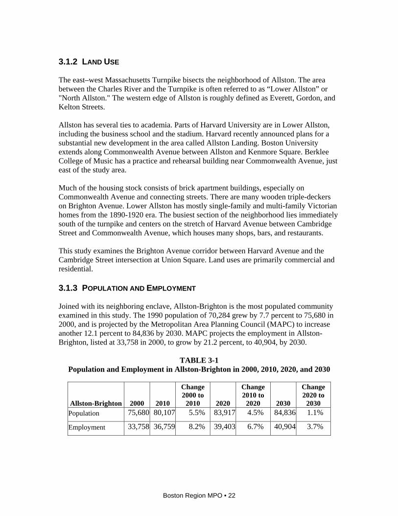
TABLE 3-1 Population and Employment in Allston-Brighton in 2000, 2010, 2020, and 2030
Allston-Brighton 2000 2010
Change 2000 to
2010 2020
Change 2010 to
2020 2030
Change 2020 to
2030 Population 75,680 80,107 5.5% 83,917 4.5% 84,836 1.1%
Employment 33,758 36,759 8.2% 39,403 6.7% 40,904 3.7%
Boston Region MPO • 22

3.1.4 TRANSPORTATION The Massachusetts Turnpike Extension, built largely on railroad right-of-way, opened in 1964 and 1965. Interchange 18-20 serves the Allston-Brighton area. Soldiers Field Road runs on the northern border of Allston-Brighton, adjacent to the Charles River. East–west numbered roads serving Allston-Brighton include U.S. Route 20 (Brighton Avenue) and State Route 30 (Commonwealth Avenue). There are no numbered north–south routes. The “B” branch of the MBTA’s Green Line serves Allston via Commonwealth Avenue. The “A” branch ran on Brighton Avenue until 1969; today its route is served by MBTA bus Route 57. Bus Routes 64, 66, 70, and 86 provide access between that neighborhood and Cambridge, Brookline, and other parts of Boston. In May 2006, Harvard University officials expressed interest in a new commuter rail stop on the Framingham/Worcester line to serve the proposed Allston Landing development. 3.1.5 CRASH DATA Between 2002 and 2006 there were 26 reported crashes involving pedestrians in Allston-Brighton, representing 1.1 percent of all crashes and resulting in eight fatalities. In the same period there were seven reported crashes involving bicyclists, representing 0.3 percent of all crashes and resulting in one fatality. As noted in Chapter 1, it is very likely that more crashes involving bicyclists and pedestrians occurred than were reported.
TABLE 3-2 Bicycle, Pedestrian, Motor-Vehicle and Total Crashes and Fatalities in
Allston-Brighton, by Number and Percentage, 2002-2006
Crashes Fatalities Mode Number Percentage Fatalities PercentageBicycle 7 0.3% 1 7.1%
Pedestrian 26 1.1% 8 57.1%
Motor vehicles (only) 2,338 98.6% 5 35.7%
All crashes (bike, ped, & motor-vehicle) 2,371 100% 14 100%
Figure 3-1 shows the locations of the bicycle and pedestrian crashes. 3.2 STUDY AREA The first part of this section of the chapter defines the study area and gives an overview of transit service and walking and bicycling conditions. Subsequent sections give more details on the different parts of the study area.
Boston Region MPO • 23

WATERTOWN
NEWTON
BROOKLINE
BELMONT
BOSTON
KENT SQUARE
BEN
TLEY
ST
BOYLSTON ST
VINELAND ST
PALM
ER
STPR
IEST
RD
COPL
EY ST
ARD
EN
RD
BENNETT ST
CENTER ST
FRANK ST
ARDEN ST
NEV
INS
ST
MAG
NO
LIA
AV
E
LOTHROP ST
EUSTON ST
CH
AN
NIN
G ST
SOUTH ST
EGMONT ST
HASKELL ST
VAN NESS ST
STI
LL ST
EVAN S RD
RANSOM RD
EDGEHILL RD
BAR
NAR
D AV
E
T UR
NE
R S
TB
E EC
HC
RO
F T ST
ESSEX RD
TRAVIS
DR
AUD
REY
ST
GAR
FIE
LD ST
STORROW DR
EAST
BUR
N ST
JAY S
T
OSBORNE RD
STET
SO
N ST
YORK TERRACE
RIV
ERD
ALE
ST
WAD
E ST
ALMY ST
NO
BSCO
T RD
CLARK RD
BEEC
HCRO
FT RD
SHERBROOKE RD
LEE
ST
SCHOOL ST
SPR
UC
E ST
WIN
SOR
AVE
RADNOR RD
MARGO RD
CYPRES S ST
LAN
GD
ON
AVE
CHA
PEL ST
STATION ST
BEECH RD
SPOONER RD
CLI
NTON RD
PREN
TICE
RD
KENWOOD ST
PILG
RIM RD
LANGLEY R D
IROQUOIS ST
BEAL
S ST
UNIVERSITY RD
NORTH HARVARD
ST
KILSYTH R
D
FULL
ER
ST
EVER
ETT
ST
CENT
RE ST
LAKE
ST
CHE
STN
UT H
ILL
AVE
GARDNER RD
GO
RD
ON
ST
QU
IMBY
ST
COLL
EG
E R
D
GALEN
ST
RAWSO N RD
COREY RD
KENT
ST
WALNUT ST
CO
MM
ON
ST
LAKE SHO RE RD
EUSTON
RD
HYD
E AV
E
GRANT
AVE
ELM ST
ORCHARD ST
SUM
NER
RD
JORDAN RD
BA
NK
S ST
GAT
E HOUS
E RD
BIG
ELOW ST
GLEN
AVE ELIOT ST
GRIGGS RD
BAILEY
RD
POND
AVE
BATE
S R
D
HYSLOP RD
ALGONQUIN R
D
SEAV ER ST
LAN E
PARK
LARCH ST
ANTR
IM ST
MASON TERRACE
FAYETTE ST
MELVIN AVE
CAROL AVE
JAM
AICAWAY
BEACON ST
MIDDLESEX
RD
AMO
RY
ST
LONGWOOD AVE
HEATH STHIG
H ST
SUTH
ERLA
ND RD
BROOKL
INE
AVE
BOYD ST
PLE
ASA
NT
ST
MAG
AZINE
ST
TREMONT ST
KENRICK ST
BABC
OC
K S
T
RIVER ST
BELMONT ST
WASHINGTON ST
SAI
NT
PAU
L S
T
NONANTUM ST WARREN ST
PEARL ST
BRAINERD RD
ALBANY ST
NAPLE
S R
D
KELTON ST
CAMBRIDGE ST
AD
AM
S S
T
PARSONS ST
ALLS
TON
ST
PARKER HILL AVE
BR
OO
KS
ST
MAR
KET
ST
ARSENAL ST
MOUNT AUBURN ST
NORTH BEACON ST
HAMMOND ST
WAI
T S
T
GREENOUG
H ST
FOST
ER S
T
WAVERLY ST
MEMORIAL DR
P
UTNAM AVE
IRVI
NG
ST
STON ELEI GH R D
BUCKMINSTER RD
RIVE
RWAY
WIN
SHIP
ST
WESTERN AVE
FANEUIL ST BRIGHTON AVE
CHURCH
ST
G LENVILLE AVE
CHARLESBANK RD
FRANKLIN ST
ASHFORD ST
LE I CESTER ST
HILLSIDE ST
FENWAY
VASSAR ST
DAVIS AVE
SUMMIT AVE
GREENOUGH BOULE
VARD
EGRE MONT RD
NEWTON ST
RENA ST
MEDFIELD ST
BELLEVUE RD
RO
YAL
ST
WAV
ER
LEY
AVE
GA
FFN
EY S
T
IVY ST
HUNTINGTON AVE
GARDNER ST
M
ARION RD
ESS
EX ST
PIERCE ST
DIG
HTO
N ST
CHARLES RIVER RD
NORF
OLK
ST
RYA
N RD
BROOK ST
CHE
RR
Y ST
PARKER ST
HOPEDALE ST
UNION ST
SAWIN ST
AUBURN ST
SUMMER ST
CH EST
NU T
HILL DRW AY
PER
RY
ST
LINE ST
TAPPAN ST
BEACONSFIELD R D
PAR
K ST
MONTVALE R D
BRAINTREE ST
HIG
GIN
S ST
SUN
SET
ST
ALLEN
RD
SIDNEY
ST
BI G
ELO
W AV
E
BRAYTON
RD
PAR
K AV
E
SEW
ALL
AVE
OAK
ST
BAY STATE RD
SMITH ST
APPI
AN
WA
Y
SPRIN
G ST
MAI
N S T
CRAFTS RD
GROVE ST
SAYBROOK ST
DEXTER AVE
FLINT RD
PARK DR
PALFREY ST
HOBART ST
MORSE ST
MARION ST
DUN
BO
Y S
T
JEFFERSON ST
RESER
VOIR
AVE
LAW
TON ST
WILLIAM STH
ILLS
IDE
RD
TERR
ACE
ST
QUEENSBERRY STNOTTINGHILL RD
PIN
E ST
PORT
INA
RD
BAY
ST
WINCHESTER ST
ARLIN
GTO
N ST
AP
PLET
ON
ST
CROSS ST
ALDIE STCHESTNUT ST
PHILLIPS ST
QUINCY RD
PRATT ST
SO
DE
N S
T
L OU
ISE
ST
COO
LIDG
E A
VE
CLYDE RD
ME
LEN
DY
AVE
LAW
RENC
E RD
FENWOOD RD
HARRIET ST
GUEST ST
GRA
SMER
E S
T
VERNON ST BELLAMY ST
SO
L DIE
RS
FIELD
RD
GRANITE ST
MAN
ET R
D
STED
MA
N ST
WEL
LAND
RD
HAG
UE
ST
EDITH AVE
ABBOTTSFORD RD
RU
SSE
LL AV
E
BR
OC
K ST
DO
DG
E S
T
ASCOT ST
FRANCIS ST
PONT
IAC
ST
WO
ODL
AWN
DR
NONANTUM RD
MAP
LE AV
E
TRAPELO ST
MONTCALM AVE
CUSHMAN RDGARDENA ST
SHATTUCK ST
MER
RILL
ST
HOLTON ST
CH
AM
PNE
Y S
T
LEE RD
ATH
OL
ST
MOUNTFORT ST
SUM
MIT
RD
CHATHAM STMONMOUTH ST
ROGERS ST
CHISWICK RD
BELLVISTA RD
PALA
CE RD
BUR
NEY
STFISHER AVE
S TUART RD
PENN
IMAN RD
ELMIRA ST
LINC
OLN
RD
ACACIA ST
WINTHROP RD
ARTH
UR
ST
WATER ST
SALISBURY RD
SEW
ALL
ST
CH
AUN
CE
Y ST
FELLSMERE RD
VINAL ST
SHAI
LER
ST
ORKNEY RD
MONTROSE ST
MALDEN ST
SOMERSET RD
HENRY ST
CLOVELLY RD
SH
OR
T S
T
RO
BBIN
S R
D
PETERBOROUGH ST
GRALYNN RD
BABBITT ST
DURANT ST
ALFR
ED R
D
BAR
NES
RD
SU
NSE
T RD
MILL ST
BIRCH
RD
DO
RR
RD
CHESHAM RDDRUCE ST
BELL
COURT
BROOKSDALE RD
HU
RD
RD
MAR
SHALL
ST
BUSWELL ST
JAMES ST
LITT
ELL
RD
ME
NLO
ST
HIB
BAR
D R
D
MEL
TON RD
ELBA ST BACK ST
HUDSON ST
AD
A IR
RD
PEABO
DY
ST
TUFTS ST
LOPEZ ST
ALCOTT ST
DEWEY ST
ALLSTON TOLL
PLAZ
A
9
2
30
2A
16
320
90
ALLSTON/BRIGHTON(P)
YAWKEY
3 3 222
2
3
53
2
4
2
43
2 2
2
7
24
3
2 5
2
2
7
16324 11
32
2
2
2
9
6
32 2
2
2
222
3
2 4
2
3
3
3
2
2 2
2
2
2
2 32 2
5
22
3
3
3
2
2
2
2
22
4
22 4 13
5
3 35 2 35
2
2 22
23
2
2
3
33
22
22
24 42
4
2 6
3
2
3
3
3
2
2
2
235
2
2 4
2
1363
2 422 2
22
232
2
23
2
2
2
3
2
2
73
322 22 9
3 LegendCrash involving:
Pedestrian
Bicyclist
Boston Region MPO
FIGURE 3-1Allston/Brighton: Crashes in 2002-2006 Involving Pedestrians and Bicyclists
Bicycle and Pedestrian Improvements in Six Urban Centers
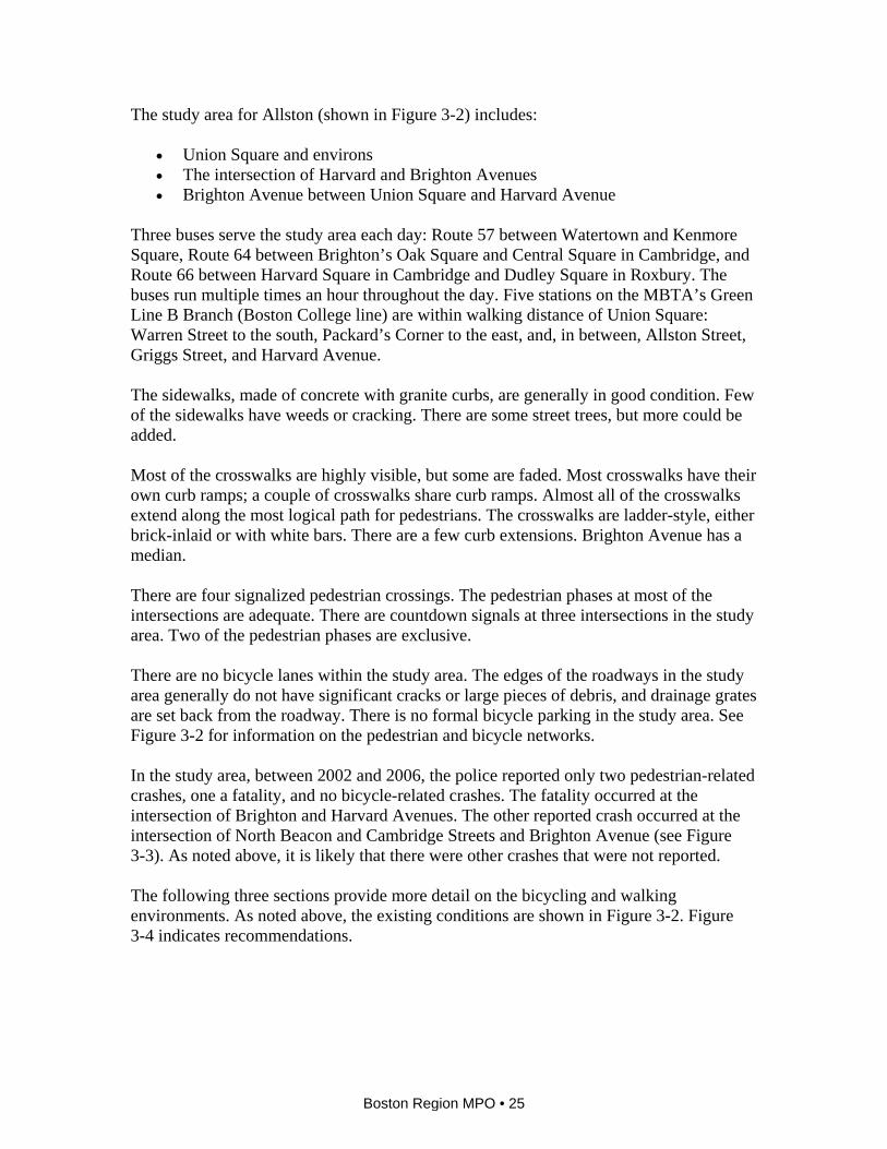
The study area for Allston (shown in Figure 3-2) includes:
• Union Square and environs • The intersection of Harvard and Brighton Avenues • Brighton Avenue between Union Square and Harvard Avenue
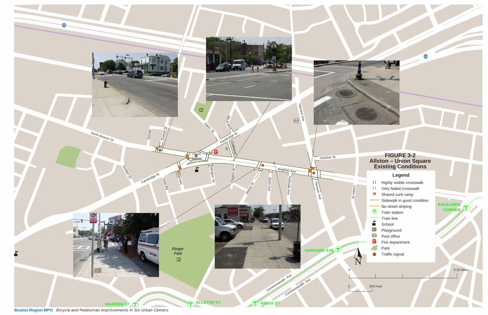
Three buses serve the study area each day: Route 57 between Watertown and Kenmore Square, Route 64 between Brighton’s Oak Square and Central Square in Cambridge, and Route 66 between Harvard Square in Cambridge and Dudley Square in Roxbury. The buses run multiple times an hour throughout the day. Five stations on the MBTA’s Green Line B Branch (Boston College line) are within walking distance of Union Square: Warren Street to the south, Packard’s Corner to the east, and, in between, Allston Street, Griggs Street, and Harvard Avenue. The sidewalks, made of concrete with granite curbs, are generally in good condition. Few of the sidewalks have weeds or cracking. There are some street trees, but more could be added. Most of the crosswalks are highly visible, but some are faded. Most crosswalks have their own curb ramps; a couple of crosswalks share curb ramps. Almost all of the crosswalks extend along the most logical path for pedestrians. The crosswalks are ladder-style, either brick-inlaid or with white bars. There are a few curb extensions. Brighton Avenue has a median. There are four signalized pedestrian crossings. The pedestrian phases at most of the intersections are adequate. There are countdown signals at three intersections in the study area. Two of the pedestrian phases are exclusive. There are no bicycle lanes within the study area. The edges of the roadways in the study area generally do not have significant cracks or large pieces of debris, and drainage grates are set back from the roadway. There is no formal bicycle parking in the study area. See Figure 3-2 for information on the pedestrian and bicycle networks. In the study area, between 2002 and 2006, the police reported only two pedestrian-related crashes, one a fatality, and no bicycle-related crashes. The fatality occurred at the intersection of Brighton and Harvard Avenues. The other reported crash occurred at the intersection of North Beacon and Cambridge Streets and Brighton Avenue (see Figure 3-3). As noted above, it is likely that there were other crashes that were not reported. The following three sections provide more detail on the bicycling and walking environments. As noted above, the existing conditions are shown in Figure 3-2. Figure 3-4 indicates recommendations.
Boston Region MPO • 25
WARREN ST ALLSTON ST GIGGS ST
HARVARD AVE
PACKARDSCORNER
0 0.25 Miles
Highly visible crosswalk
Very faded crosswalk
Shared curb ramp
Sidewalk in good condition
No street striping
Train station
Train line
School
Playground
Post office
Fire department
Park
Traffic signal
Legend
FIGURE 3-2Allston – Union Square
Existing Conditions
PG
PO
F
PG
PO
F
PG
Sin
clai
r
Eve
rett
St
North Beacon St
Gordon S
t
Parkvale A
ve
Quint A
ve
Harvard
Ave
Hig
gins
St
St
Islington
Barrow
s
Imrie R
d
Harvard
Ave
St
Craftsm
an
SquareUnion
Em
ery R
d
Hano St
Cambridge StLinden S
t
Gardner St
Alls
ton
St
ParkRinger
Cambridge St
Brighton Ave
CommonwealthAve
CommonwealthAve
90
90
300 Feet0
N
Boston Region MPO Bicycle and Pedestrian Improvements in Six Urban Centers
CAMBRIDGE STREET
HA
RVA
RD
AVE
NU
E
ADELLA
PLACE
ISLIN
GTO
N
TER
RA
CE
IMR
IE S
TRE
ET
WILTO
N
STREET
HANO STREET
BRIGHTON AVENUE
ALLS
TON
STR
EET
HIG
GIN
S S
TRE
ET
NORTH BEACON STREET
GARDNER STREET
HARVESTER STREET
GRIGGS PLACE
ARMINGTON STREET
CLEVEMONT AVENUE
HOLLIS PLACE
FARRINGTON AVENUE
SIN
CLA
IR R
OA
D
CR
AFTS
MA
N S
TRE
ET
WE
BLE
Y S
TRE
ET
HIG
HG
ATE STR
EET
DENBY
ROAD
HARVARD TERRACE
BA
RR
OW
S S
TRE
ET
PEN
NIM
AN R
OAD
EMER
Y R
OAD
CAM
BR
IDG
E
TER
RAC
E
PAR
K VA
L E A V
EN
UE
QU
I NT
AVE
NU
E
EV
ER
ETT
STR
EE
T
ISLIN
GTO
N S
TRE
ET
RUG
G R
OAD
BOSTON
LegendStudy Area
Crash involving:Pedestrian fatality
Pedestrian
FIGURE 3-3Union Square, Allston
Boston Region MPO
Crashes in 2002-2006 Involving Pedestrians and Bicyclists
Bicycle and Pedestrian Improvements in Six Urban Centers
WARREN ST ALLSTON ST GRIGGS ST
HARVARD AVE
PACKARDSCORNER
0 0.25 Miles
Highly visible crosswalk
Very faded crosswalk
Shared curb cut
Sidewalk in good condition
No street striping
Train station
Train line
School
Playground
Post office
Fire department
Park
Traffic signal
Legend
FIGURE 3-2Allston – Union Square
Existing Conditions
PG
PO
F
PG
PO
F
PG
Sin
clai
r
Eve
rett
St
North Beacon St
Gordon S
t
Parkvale A
ve
Quint A
ve
Harvard
Ave
Hig
gins
St
St
Islington
Barrow
s
Imrie R
d
Harvard
Ave
St
Craftsm
an
SquareUnion
Em
ery R
d
Hano St
Cambridge StLinden S
t
Gardner St
Alls
ton
St
ParkRinger
Cambridge St
Brighton Ave
CommonwealthAve
CommonwealthAve
90
90
300 Feet0
N
PO
Legend
F
Recommendation number
Add bike parking
Move crosswalk
Add curb extension
Add curb ramp
Train station
Train line
School
Library
Post office
Fire department
Municipal building
Community center
Park
Traffic signal
CURB +
#
FIGURE 3-4Allston – Union Square
Recommendations
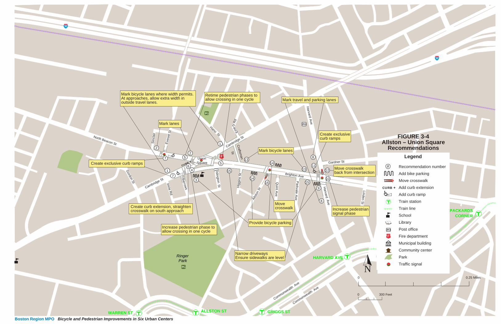
14
143
5
5
46
1
1
9
15
15
13
1311
7
7
2
2
10
8
8
12
16
CURB +
Mark lanes
Mark bicycle lanes where width permits.At approaches, allow extra width inoutside travel lanes.
Create curb extension, straightencrosswalk on south approach
Create exclusive curb ramps
Provide bicycle parking
Narrow drivewaysEnsure sidewalks are level
Increase pedestriansignal phase
Move crosswalkback from intersection
Mark bicycle lanes
Increase pedestrian phase toallow crossing in one cycle
Retime pedestrian phases toallow crossing in one cycle
Movecrosswalk
Create exclusivecurb ramps
Mark travel and parking lanes
Boston Region MPO Bicycle and Pedestrian Improvements in Six Urban Centers

3.2.1 UNION SQUARE AND ENVIRONS Union Square, the intersection of Cambridge and North Beacon Streets and Brighton Avenue, is a busy intersection in the heart of Allston. Cambridge Street connects to the Massachusetts Turnpike just over a mile to the northeast. Brighton Avenue is a major east–west connector in the area. The primary land use here is commercial. There is a public school located on the south side of the intersection and a fire station in the northeast corner.
Union Square, Allston: The intersection of Cambridge Street with Brighton Avenue on the right and North Beacon Street on the left.
Bicycling Existing Conditions Both east and west of Union Square, Cambridge Street, which is 48 to 56 feet wide, consists of a travel lane and a parking lane in each direction. On the north approach, the one travel lane expands to two when the parking lane ends. There are two travel lanes and a parking lane on the other side of the intersection heading southbound, and the two travel lanes narrow to one lane. Approaching from the south, there are three northbound lanes: two through lanes, and a right-turn lane. There are no left turns allowed. Approaching the Square from the west, North Beacon Street, which is 41 feet wide, changes from one travel lane and one parking lane to two travel lanes. Heading westbound from the Square on North Beacon Street, there is one travel lane and then, after one block, both a travel lane and a parking lane. Heading westbound on Brighton Street into the intersection, there are two left-turn lanes,
Boston Region MPO • 29

a through lane, and an exit for right-turning traffic before the island. Leaving the intersection eastbound, Brighton Avenue consists of two travel lanes and a parking lane. There are no bicycle lanes or bicycle parking. The edge of the pavement on North Beacon Street is rough. Recommendations
1. Where Cambridge Street is 48 feet wide and there is a travel lane and a parking lane in each direction, stripe 11-foot travel lanes, 6-foot bicycle lanes, and 7-foot parking lanes. On the northbound approach (Cambridge Street), mark an 11-foot-wide leftmost through lane and right-turn lane, with the remainder for the rightmost through lane. On the southbound approach, mark the inner lane 11 feet wide and the parking lane 7 feet wide, with the remainder for the outer lane.
2. Mark North Beacon Street, where the width is 41 feet, with 7-foot-wide parking
lanes and 10-foot-wide travel lanes. This leaves a 3.5-foot-wide marked space between the travel lanes and the parking lanes for bicycles, not wide enough for marked bicycle lanes. Improve the pavement condition, especially along the edges.
3. Install bicycle parking on the southeast corner, by the school, covered if possible.
Walking Existing Conditions There are street trees on the south side of the intersection in front of the school, along the fire station on the northeast corner, and on Cambridge Street north of the intersection. There is a brick-paved island with trees and benches on the northeast corner of the intersection. The crosswalks are ladder-style, inlaid with brick-pattern pressed concrete. They are highly visible and in very good condition. Most of the crosswalks have separate curb ramps. There is a shared curb ramp where the crosswalks on Cambridge and North Beacon Streets meet on the southwest corner. The two crosswalks that meet at Cambridge and Barrows Streets also share a curb ramp. There are no curb extensions. Union Square has a four-way stoplight with pedestrian-activated crossing signals. There are medians with pedestrian signals in the middle of Brighton Avenue, North Beacon Street, and the south approach of Cambridge Street. The signal has a somewhat concurrent pedestrian phase consisting of (clockwise) an 11-second “Walk” and a 10-second flashing “Don’t Walk” signal across the north approach of Cambridge Street; a 6- second “Walk” and a 15-second flashing “Don’t Walk” signal and a 9-second “Walk” and an 11-second flashing “Don’t Walk” signal across Brighton Avenue; an 11-second
Boston Region MPO • 30

“Walk” and a 10-second flashing “Don’t Walk” signal across the south approach of Cambridge Street; and a 7-second “Walk” and a 16-second flashing “Don’t Walk” signal and a 10-second “Walk” and a 10-second flashing “Don’t Walk” signal across North Beacon Street. The crosswalks, clockwise, are 70, 69 (35 plus 26 with an 8-foot median), 118, and 94 feet long (62 plus 28 with a 4-foot median). Using a 3.5-foot-per-second standard, the pedestrian phase is adequate for two of the lengths of the crossings, barely adequate for the north side of the intersection (Cambridge Street), and not adequate for the south approach (Cambridge Street) unless pedestrians stop in the middle in the median and wait through a cycle for a new “Walk” signal. Pedestrians are unlikely to do this. The pedestrian phase for the east and west approaches of the intersection are adequate yet undesirable since pedestrians have a “Walk” signal across only half of the street. There they must stop and wait for the next “Walk” signal. Waiting in the middle of the street even with a median can be dangerous, and certainly unpleasant, for pedestrians, as motor vehicles move fast through here. North Beacon and Everett Streets – The intersection has a three-way stoplight with pedestrian-activated crossing signals. The signal has an exclusive pedestrian phase consisting of a 6-second “Walk” signal and a 10-second flashing “Don’t Walk” signal. The two ladder-style crosswalks are 47 feet across North Beacon Street and 43 feet across Everett Street. Using the 3.5-foot-per-second standard, the pedestrian phase is adequate for the lengths of the crossings. Recommendations 4. Increase the pedestrian signal phase across Cambridge Street by at least 13 seconds to
allow pedestrians to cross the south approach of the intersection in one cycle.
5. Retime the pedestrian phases so that pedestrians crossing North Beacon Street or Brighton Avenue can do so in one phase.
6. Create a curb extension on the east side of the southwest corner, on Cambridge Street, and create curb ramps. This will allow the crossing of North Beacon Street to be straightened and shortened. Likewise straighten the crossing for the south approach, across Cambridge Street, thereby shortening it. This also will decrease slightly the time required for the pedestrian phases.
7. Create exclusive curb ramps for the crosswalks at Cambridge and Barrows Streets and at North Beacon and Everett Streets.
3.2.2 INTERSECTION OF HARVARD AND BRIGHTON AVENUES Harvard Avenue is a major north–south route in this area. Its name changes to Harvard Street in Brookline, where it goes through Coolidge Corner to Brookline Village, another urban center discussed in this study (see Chapter 4). Brighton Avenue extends from where Commonwealth Avenue turns southward, at Packards Corner, about a mile east of the study area, to North Beacon Street. The primary land use at this intersection is commercial.
Boston Region MPO • 31
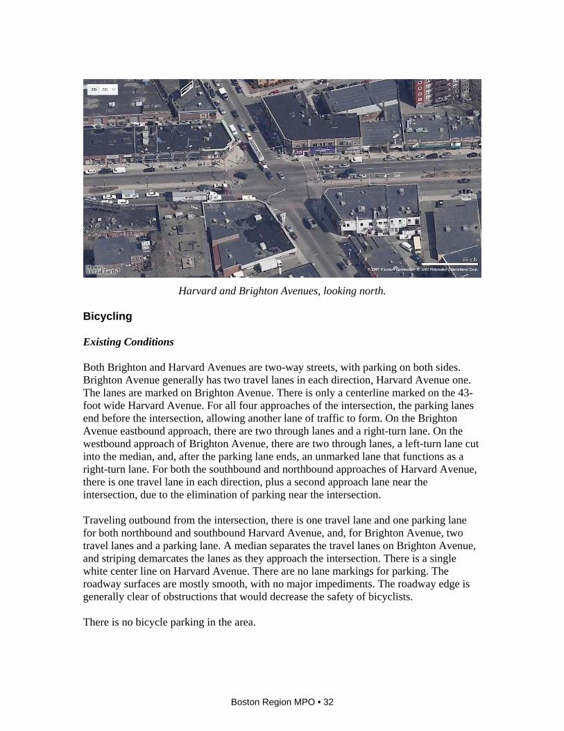
Harvard and Brighton Avenues, looking north.
Bicycling Existing Conditions Both Brighton and Harvard Avenues are two-way streets, with parking on both sides. Brighton Avenue generally has two travel lanes in each direction, Harvard Avenue one. The lanes are marked on Brighton Avenue. There is only a centerline marked on the 43-foot wide Harvard Avenue. For all four approaches of the intersection, the parking lanes end before the intersection, allowing another lane of traffic to form. On the Brighton Avenue eastbound approach, there are two through lanes and a right-turn lane. On the westbound approach of Brighton Avenue, there are two through lanes, a left-turn lane cut into the median, and, after the parking lane ends, an unmarked lane that functions as a right-turn lane. For both the southbound and northbound approaches of Harvard Avenue, there is one travel lane in each direction, plus a second approach lane near the intersection, due to the elimination of parking near the intersection. Traveling outbound from the intersection, there is one travel lane and one parking lane for both northbound and southbound Harvard Avenue, and, for Brighton Avenue, two travel lanes and a parking lane. A median separates the travel lanes on Brighton Avenue, and striping demarcates the lanes as they approach the intersection. There is a single white center line on Harvard Avenue. There are no lane markings for parking. The roadway surfaces are mostly smooth, with no major impediments. The roadway edge is generally clear of obstructions that would decrease the safety of bicyclists. There is no bicycle parking in the area.
Boston Region MPO • 32
Recommendations 8. On Harvard Avenue, mark 7-foot parking lanes and 10-foot travel lanes, leaving a 4.5-
feet-wide space for bicycles, too narrow to be marked as a bicycle lane. 9. Provide bicycle parking, preferably under cover, as close to the commercial area as
possible. One option would be to remove the parking spot located immediately before a crosswalk and place bicycle parking there. This also would provide the benefit of a curb extension, increasing the visibility of pedestrians in the crosswalk.
Walking Existing Conditions There are parallel-bar crosswalks inlaid with brick-pattern pressed concrete at all approaches of the intersection. All the curb ramps are separate except for a shared one on the northwest corner. The intersection has a four-way stoplight with pedestrian-activated crossing signals. The signal has an exclusive pedestrian phase consisting of a 7-second “Walk” signal and a 12-second flashing “Don’t Walk” signal. There are medians with push buttons halfway across Brighton Avenue on the east and west approaches of the intersection. Clockwise, the crosswalks are 67, 74, 56, and 74 feet long. Using a 3.5-foot-per-second standard, the pedestrian phase is not adequate. There are street trees on Brighton Avenue, but not on Harvard Avenue. Recommendations
10. Increase the pedestrian signal phase by at least three seconds.
11. Construct separate curb ramps for the crosswalks on the northwest corner of the intersection.
12. Move the crosswalk further north on the north approach. This will shorten the distance for crossing pedestrians and also require motorists to look for pedestrians before entering the intersection. Although there is a “No Right Turn on Red” sign, field observations indicate that it is not always obeyed. Move the stop lines further back from the crosswalks.
3.2.3 BRIGHTON AVENUE BETWEEN UNION SQUARE AND HARVARD AVENUE Brighton Avenue is a major arterial connector between Allston and points east and west. This area is primarily commercial, consisting of storefronts, a strip development, and a fast-food establishment.
Boston Region MPO • 33

Bicycling Existing Conditions Brighton Avenue consists of two travel lanes and one parking lane in each direction and a wide, sometimes planted median. The width on each side of the median is approximately 32 feet, accommodating two travel lanes and a parking lane.
There is no bicycle parking along this corridor. Recommendations 13. Given a 32-foot width on each side of the median, mark a 7-foot parking lane, a
5-foot bicycle lane, and two 10-foot travel lanes. 14. Provide bicycle parking, preferably covered, as close to commercial areas as possible.
One option would be in the commercial parking lots, if the owners were amenable to installing them. Another option is to place parking adjacent to trees on the sidewalks, in areas that would not interfere with pedestrians.
Walking Existing Conditions Close to the intersection of Brighton and Harvard Avenues, storefronts line the sidewalks on both sides of the street, helping to create a pleasant walking environment. Further west, commercial driveways cross the sidewalk. For example, there is a strip development on the north side, with parking in front and two wide driveways. There is a fast-food restaurant on the south side, with two driveways on Brighton Avenue. The sidewalks generally slope down to the level of the intersecting driveways. There are trees on the south side of Brighton Avenue and vegetation along the median strip. The Brighton Avenue and Allston Street intersection has a three-way stoplight with pedestrian-activated crossing signals. The signal has an exclusive pedestrian phase with a countdown signal. There are crosswalks on the west and south approaches. The crosswalks on the southwest corner share a curb ramp. Recommendations 15. Narrow the intersecting driveways wherever possible both to reduce the crossing
distance for pedestrians and to slow the entering and exiting motor vehicles. Ensure that sidewalks are level and not sloping down for driveways.
16. Move the crosswalk that crosses Allston Street further back from the street, create
separate curb ramps, and increase the distance between the crosswalk and the stop line.
Boston Region MPO • 34


![Classification: Decision Trees · Basic Algorithm for Top-Down Learning of Decision Trees [ID3, C4.5 by Quinlan] node= root of decision tree Main loop: 1. Aßthe “best” decision](https://static.fdocuments.in/doc/165x107/5ec67d03ae6d2609843381e5/classification-decision-trees-basic-algorithm-for-top-down-learning-of-decision.jpg)


