Precipitation and its forms (hydrology)
38
-
Upload
maha-sabri -
Category
Environment
-
view
193 -
download
0
Transcript of Precipitation and its forms (hydrology)


PRECIPITATION
PRESENTED BY:
Maha Sabri
(M.SC-Part1)
Mountain Conservation And Watershed Management.

PRECIPITATION• Introduction
• Forms of precipitation
• Mechanism of precipitation
• Classification
• Measurement of precipitation
• Types of rain gauges

Precipitation
• Definition:
• Fall of moisture from atmosphere in any form.
• Precipitation is any product of the condensation of water vapours that fall under gravity.
• It is an important input to hydrology.
• Floods and droughts are directly related to precipitation.
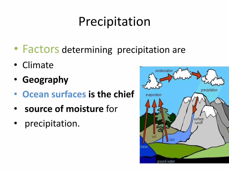
Precipitation
• Factors determining precipitation are
• Climate
• Geography
• Ocean surfaces is the chief
• source of moisture for
• precipitation.
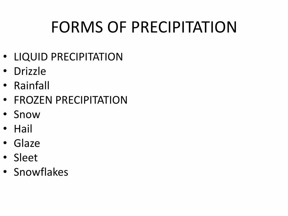
FORMS OF PRECIPITATION
• LIQUID PRECIPITATION• Drizzle• Rainfall• FROZEN PRECIPITATION• Snow • Hail• Glaze• Sleet • Snowflakes

Forms of precipitation

Forms of precipitation

Forms of precipitation
• hail

Mechanism of precipitation

Mechanism of precipitation
• All precipitation originates from parcels of moist air that have been cooled below dew-point temperature.
• Lifting mechanism to cool the air.
• Formation of cloud elements(droplets/ice crystals)
• Growth of cloud elements.
• Sufficient accumulation of cloud elements.

Convective precipitation
It results from heating of earth’s surface that cause air to rise rapidly. As the air rises it cools and moisture condenses into clouds and PRECIPITATION.

Cyclonic precipitation(frontal/non frontal)
• when two air masses due to contrasting temperatures and densities clash with each other ,condensation and precipitation occur at the surface of contact.

Orographic precipitation
• When heavily moisture laden air stops due to topographic conditions (mountains)and precipitation occurs on the windward side of the mountain while leeward side receives very little .just like in Himalayan region.

Measurement of precipitation
• 1. Amount of precipitation
• 2. Intensity of precipitation
• 3. Duration of precipitation
• 4. Arial extent of precipitation

Measurement of precipitation (Rain and Snow) can be done by various devices. These measuring devices and techniques are;
Rain Gauges Snow Gauges Radars Satellites Scratching of snow packs Water equivalent in snow packs
Measurement Methods

RAIN GAUGES
Rain gauges are most commonly used for the measurement of precipitation, both in terms
of rain fall and snow.

Types of rain gauges
1. Non recording rain gauges
2. Recording rain gauges

Non recording rain gauges
• It is a rain gage which does not provide the distribution of amount of precipitation in a day. It simply gives the amount of precipitation after 24 hours (daily precipitation

Recording rain gauges
• These rain gauges are also called integrating rain gauges since they record cumulative rainfall. In addition to the total amount of rainfall at a station, it gives the times of onset and cessation of rains (thereby gives the duration of rainfall events)

• There are three main types of recording rain gauges
• 1. Float type rain gages
• 2. Tipping bucket type rain gages
• 3. Weighing type rain gages
Types of recording Rain gauges

2.Tipping Bucket Rain-gauge• Consists of 30 cm dia sharp edgereceiver.• At the end of receiver funnel isprovided.• Under the funnel a pair of buckets arepivoted (the central point whichbalances) in such away that when onebucket receives 0.25 mm (0.01”) ofrainfall it tips (to fall or turn over),discharging its contents into reservoirbringing other bucket under funnel.• Tipping of bucket completes anelectric circuit causing the movementof pen to mark on clock drivenrevolving drum which carries arecord sheet

Weighing Bucket Rain-gauge
• • Consists of a receiver• bucket supported by a• spring or lever balance or• any other weighing• mechanism.• • The movement of bucket• due to its increasing• weight is transmitted to a• pen which traces the• record on a clock driven• chart.

Float Type Rain-gauge
• The rise of float with increasing catch of rainfall is recorded. Some gauges must be emptied manually while others are emptied automatically using self starting siphons. In most gauges oil or mercury is the float and is placed in the receiver, but in some cases the receiver rests on a bath of oil or mercury and the float measures the rise of oil or mercury displaced by the increasing weight of the receiver as the rainfall catch freezes. Float may get damaged by rainfall catch freezer
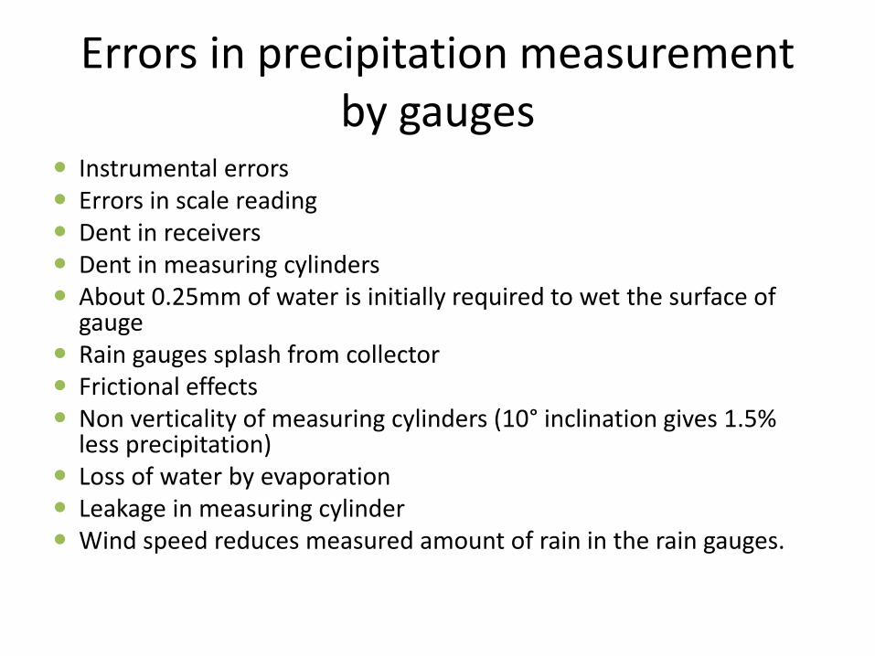
Errors in precipitation measurement by gauges
Instrumental errors Errors in scale reading Dent in receivers Dent in measuring cylinders About 0.25mm of water is initially required to wet the surface of
gauge Rain gauges splash from collector Frictional effects Non verticality of measuring cylinders (10° inclination gives 1.5%
less precipitation) Loss of water by evaporation Leakage in measuring cylinder Wind speed reduces measured amount of rain in the rain gauges.

Average precipitation over an area
• • In order to compute the average rainfall over a basin or
• catchment area, the rainfall is measured at a number of raingaugestations suitably located in the area.
• • The no. of rain-gauge stations depends upon the area and
• distribution of rainfall.
• • If a basin or catchment area contains more than one raingaugestation, the computation of average rainfall may be
• done by the following methods:
• 1. Arithmetic average method.
• 2. Thiessen polygon method.
• 3. Isohytel method.

1.Arithmetic average method.
• Precipitation over area area is arithmetic average of gauge precipitation values.
• Simplest method but only applicable when basin area is flat.
• All stations with in practical limit uniformly distributed over area.
• Rainfall is also nearly uniformly distributed over area.
• P1,P2…….Pn=no of precipitation
• N=no of gauges
• I=stations

2.Thiessen polygon method.• This method is a more common method of weighing the rain gauge observation according to the area.• Also called Weighted Mean Method.• Accurate than arithmetic average method.• Average rainfall can be computed by the followingexpression.

2.Thiessen polygon method.
• 1. Join the adjacent rain-gauge stations.• 2. Construct the perpendicular bisectors of each of these lines.• 3. The polygon formed by the perpendicular bisectors around• a station encloses an area encloses an area which is every• where closer to that station than to any other station.• 4. Find the area of each of these polygons, shown hatched in• the figure.• 5. Compute the average precipitation using the given formula.

2.Thiessen polygon method.
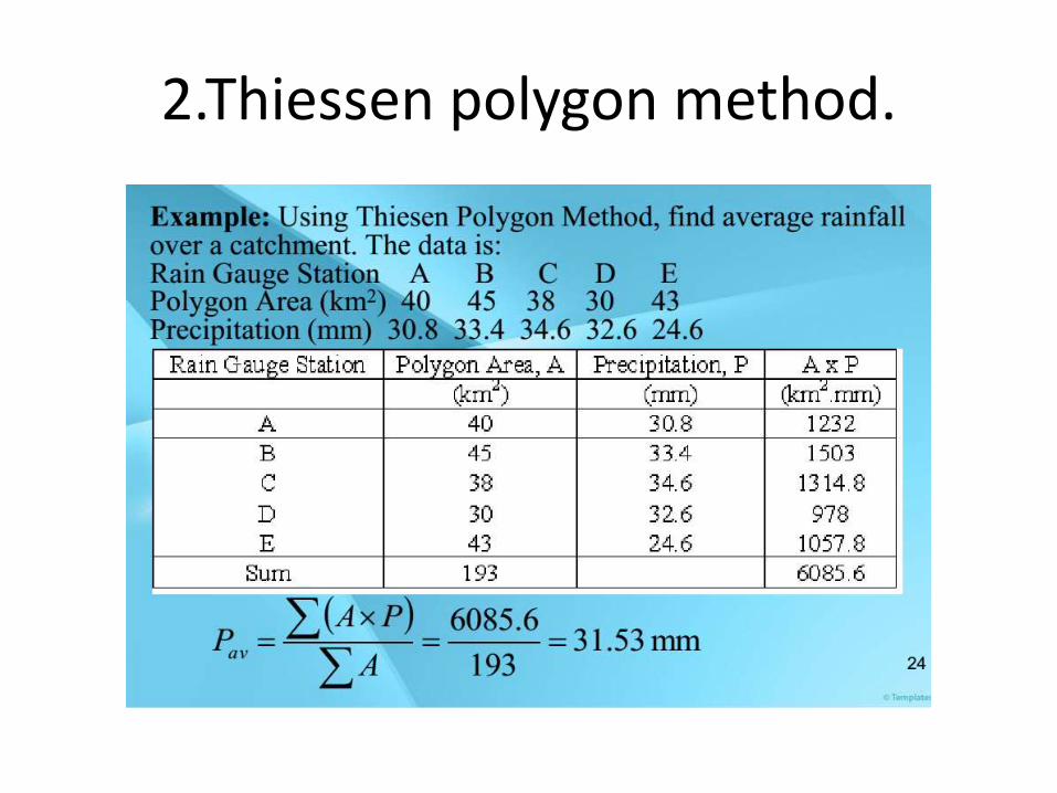
2.Thiessen polygon method.
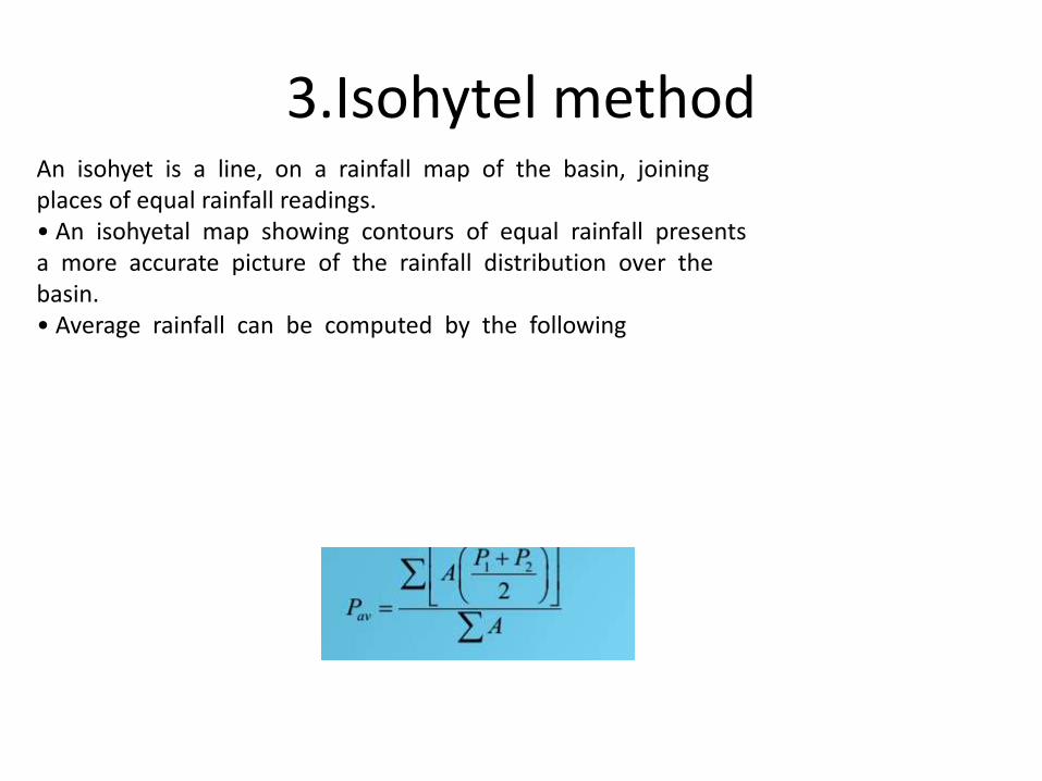
3.Isohytel methodAn isohyet is a line, on a rainfall map of the basin, joiningplaces of equal rainfall readings.• An isohyetal map showing contours of equal rainfall presentsa more accurate picture of the rainfall distribution over thebasin.• Average rainfall can be computed by the following

Isohytal method
Plot gauge locations on a map;
Subjectively interpolate between rain amountsbetween gauges at a selected interval;
Connect points of equal rain depth to produce lines of equal rainfall amounts (isohyets);

Isphytel method
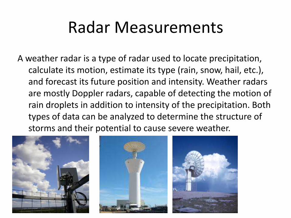
Radar Measurements
A weather radar is a type of radar used to locate precipitation, calculate its motion, estimate its type (rain, snow, hail, etc.), and forecast its future position and intensity. Weather radars are mostly Doppler radars, capable of detecting the motion of rain droplets in addition to intensity of the precipitation. Both types of data can be analyzed to determine the structure of storms and their potential to cause severe weather.

Satellite Measurements
A weather satellite is a type of satellite that is primarily used to monitor the weather and climate of the Earth.Thesemeteorological satellites, however, see more than clouds and cloud systems, like other types of environmental information collected using weather satellites.
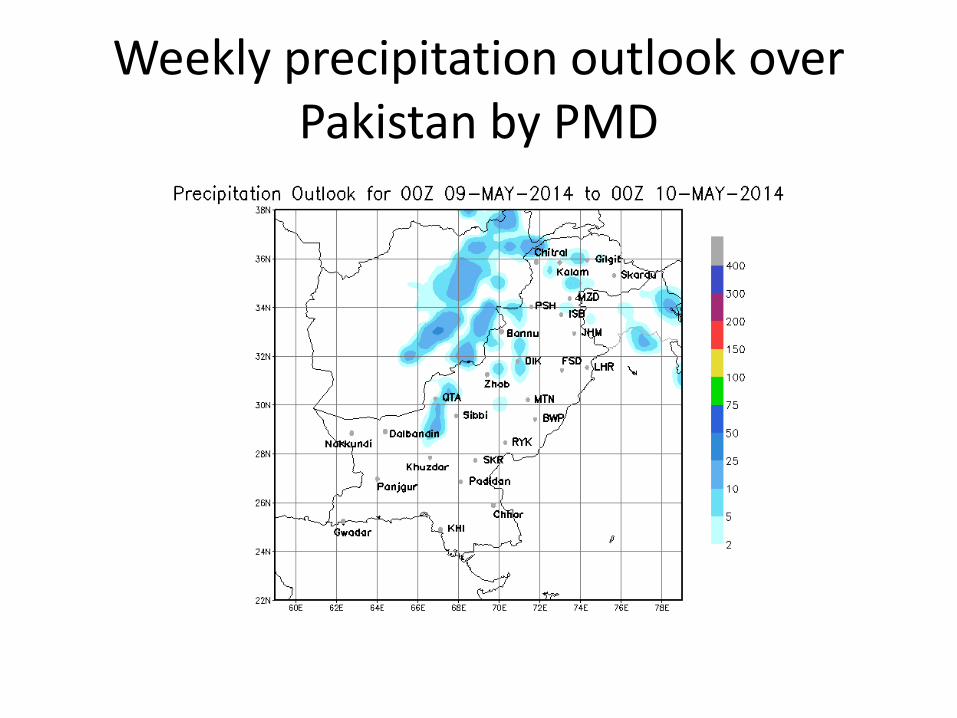
Weekly precipitation outlook over Pakistan by PMD