PRE-FEASIBILITY REPORT FOR NATRAJ UNDERGROUND COAL …€¦ · Natraj Underground Project (0.64...
14
CMPDI Job No.706147 Pre-Feasibilty Report, Page - 1 PRE-FEASIBILITY REPORT FOR NATRAJ UNDERGROUND COAL MINE PROJECT PROPOSED CAPACITY – 0.64 MTY 1. INTRODUCTION Natraj Underground Coal Mine Project is a part of Talcher Coalfield. Talcher coalfield, located in river Brahmani valley to the north of Mahanadi river, constitutes the south eastern member of lower Gondwana basin within Mahanadi valley group of coalfields. The coalfield spreads over 80km on the strike (east-west) and 26km on dip rise (north-south) covering an area of about 1860 sq.km (coal bearing) of which about 201 sq.km has been explored in detail in the southern part of the coalfield. In the northern part, an area of about 53 sq.km. has also been explored in detail. Major portion of coalfield is situated in the district of Angul of Orissa, whereas part areas of the coalfield spread over to Dhenkanal, Deogarh and Sambalpur districts. Natraj Underground Project (0.64 Mty) is a proposed coal mining project. 296.47 Ha land is required for this project which has already been acquired under Coal Bearing Area (Acquisition & Development) Act, 1957 vide Gazette Notification No. S.O. 3687 Dt.29/11/1962. The high quality coal (B&D grade) produced through eco-friendly fully mechanized underground mining method will be used for blending with high ash coal of opencast mines of Talcher Coalfield for long distance power plants so that overall ash % is less than 35%. Continuous miner with shuttle car and side discharge loader (SDL) has been envisaged for extraction of coal. 2. STATUS OF NATRAJ UNDERGROUND COAL MINE PROJECT Coal Mine not yet started. STATUS OF ENVIRONMENT CLEARANCE EC granted vide J-11015/306/2005-IA.II (M) dated 14.07.2006 under provisions of EIA notification, 1994.
Transcript of PRE-FEASIBILITY REPORT FOR NATRAJ UNDERGROUND COAL …€¦ · Natraj Underground Project (0.64...
CMPDI
Job No.706147 Pre-Feasibilty Report, Page - 1
PRE-FEASIBILITY REPORT
FOR
NATRAJ UNDERGROUND COAL MINE PROJECT
PROPOSED CAPACITY – 0.64 MTY
1. INTRODUCTION
Natraj Underground Coal Mine Project is a part of Talcher Coalfield. Talcher
coalfield, located in river Brahmani valley to the north of Mahanadi river, constitutes
the south eastern member of lower Gondwana basin within Mahanadi valley group of
coalfields.
The coalfield spreads over 80km on the strike (east-west) and 26km on dip
rise (north-south) covering an area of about 1860 sq.km (coal bearing) of which about
201 sq.km has been explored in detail in the southern part of the coalfield. In the
northern part, an area of about 53 sq.km. has also been explored in detail. Major
portion of coalfield is situated in the district of Angul of Orissa, whereas part areas of
the coalfield spread over to Dhenkanal, Deogarh and Sambalpur districts.
Natraj Underground Project (0.64 Mty) is a proposed coal mining project.
296.47 Ha land is required for this project which has already been acquired under
Coal Bearing Area (Acquisition & Development) Act, 1957 vide Gazette Notification
No. S.O. 3687 Dt.29/11/1962. The high quality coal (B&D grade) produced through
eco-friendly fully mechanized underground mining method will be used for blending
with high ash coal of opencast mines of Talcher Coalfield for long distance power
plants so that overall ash % is less than 35%.
Continuous miner with shuttle car and side discharge loader (SDL) has been
envisaged for extraction of coal.
2. STATUS OF NATRAJ UNDERGROUND COAL MINE PROJECT
Coal Mine not yet started.
STATUS OF ENVIRONMENT CLEARANCE
EC granted vide J-11015/306/2005-IA.II (M) dated 14.07.2006 under
provisions of EIA notification, 1994.

CMPDI
Job No.706147 Pre-Feasibilty Report, Page - 2
STATUS OF FOREST CLEARANCE
Forest clearance was obtained for forest land 289.856 Ha vide letter no. 8-
73/2004 - FC dated 30-06-2009 Government of India, MoEF- FC Division.
3. NEED / JUSTIFICATION FOR THE PROJECT
The Natraj UG mine (0.64 Mty) obtained the environmental clearance under
the provision of EIA Notification, 1994 and subsequent amendments. Now as per
Gazette notification S.O 1530(E) on dated 06/04/2018, the projects obtained their
environment clearances under EIA notification, 1994 are required to obtain
environmental clearances under EIA notification, 2006. So the Form I and Brief Note
is prepared for the Revalidation of EC under EIA notification, 2006.
Further, as Nandira U/G extended its lease area to the adjoining lease hold
area of Natraj, the area of Natraj reduced from 386.68 Ha to 296.47 Ha for which
amendment in EC is required.
Public Hearing (PH) already held for the entire mine lease area (i.e.
483.227) hence the PH may be exempted for this proposal of reduction in lease area
(i.e. 296.47 Ha).
4. OBJECTIVES OF THE PROJECT:
To supply coal for blending with high ash coal of opencast mines of
Talcher coalfield for long distance power plants.
To create conditions for growth of other ancillary industries in the region.
5. LOCATION AND COMMUNICATION
LOCATION
The project under study is located in the south-central part of Talcher
Coalfield under Talcher Area of MCL.
Coalfield Talcher
Area Talcher
District Angul

CMPDI
Job No.706147 Pre-Feasibilty Report, Page - 3
Latitudes 20o55’09” & 20o56’20” N
Longitudes 85o04’38” & 85o06’12” E
Topo Sheet No. F45 T1
COMMUNICATION
Sl.No. Item Particulars
1. Nearest town Town: Talcher, Distance - 12 Km District: Angul, distance - 25 km
2. Nearest road Talcher-Gopalprasad road passes through the north-eastern part of the block.
3. National highways Cuttack-Sambalpur National highway No.55 is located to the south of the block and approachable at a distance of about 17 km.
4. Connection to the state capital
167 km to Bhubaneswar via NH-55 & NH-5.
5. Connection to the company HQs
195 km to Sambalpur via NH-55 & NH-6.
6. Nearest railhead Talcher railway station on branch line of East Coast Railway is at a distance of about 12 km.
7. Airport Biju Pattanaik Airport in Bhubaneswar is at a distance of about 172 km.
6. TOPOGRAPHY, DRAINAGE AND CLIMATE
The project area is gently undulating landscape with a few low ridges in the
south-eastern part of the block. The general slope is gentle and towards north.
Lowest and highest elevations of the area are 118.92 m and 170.81 m respectively
above MSL.
The Brahmani river on the eastern extremity of the coalfield mainly controls
drainage in the area. There is one seasonal nullah, Bangaru jhara that flows in the
north side of the block and drains into the Brahmani river at the north of Talcher town.
There are also some more seasonal nullahs traversing the block.
The project area experience a tropical climate with average annual rainfall
of 1270 mm and mean minimum daily temperature of 6.70C and mean maximum
daily temperature of 45.50C . Mean wind speed ranges from 1 km/hr to 8 km/hr.

CMPDI
Job No.706147 Pre-Feasibilty Report, Page - 4
7. GEOLOGY
Structural interpretation of the block is mainly based on subsurface data
because the entire area is either covered with thick soil or by laterite and Barakar
boulders. General strike of the bed is east-west with northerly dip. Local variation in
dip and strike is very common.
General direction of the dip is towards north with local swings. The amount of
dip varies from 2o-3o in the western part, 6o-7o in the central part and 4o-5o in the
north eastern corner of the block.
In all nine (9) faults have been deciphered in Natraj block. All these faults
except F8-F8 have already been proved in the adjoining Nandira block. Faults F6,
F8 and F9 have been intersected in the boreholes NTR-23, 24 and 6 respectively, the
remaining faults have been deciphered mainly on the basis of difference in the floor
levels.
Sequence of Coal Seams and Intervening Parting
Formation Lithology Thickness range (m)
Recent & sub-recent
Alluvial soil 0.50 (NTR-27) 4.00 (NT-4)
Laterite 0.50 (NTR-16) 5.50 (NTR-28)
U Barakar L
Sandstone, shales and coal seams
8.00 (NTR-22) 69.50 (NTR-24)
Pebbles & boulders 1.50 (NTR-28) 29.70 (NTR-29)
KARHAR BARI
Sandstone 48.16 (NT-13) 132.61 (NT-16)
Seam-I T (combined) 2.34 (NTR-34) 8.51 (NTR-58)
Seam-I T2 0.07 (NT-2) 3.90 (NTR-30)
Sandstone/Sandy shale 0.70 (NTR-7) 7.50 (NT-18)
Seam-I T1 0.12 (NTR-11, NT-15)
4.02 (NTR-44)
Sandstone/Sandy shale 2.01 (NTR-29) 16.04 (NTR-16)
[w.r.t Seam-I T (comb.)]
0.56 (NTR-44) 18.77 (TCH-7)
(W.R.T Seam-I T1)
Seam-I Middle 0.05 (NTR-27) 3.88 (NTR-15)
Sandstone/Sandy shale 0.70 (NTR-22) 8.76 (TLR-154)
Seam-I Bottom 0.05 (NTR-32) 3.30 (NT-12)
Talchir Greenish Sandstone/shale 78.72 (NTR-20)
CMPDI
Job No.706147 Pre-Feasibilty Report, Page - 5
Note: 1. Metamorphic are neither exposed anywhere within the block nor any
borehole was drilled deep enough to intersect them.
2. Talchir has not been exposed within the block. No borehole was drilled
to intersect full thickness of Talchir except NTR-20 in which only part
thickness (78.72m) of Talchir formation has been intersected.
3. West central and north central part of the block is covered under thick
soil (0.50m to 4.00m) and rest of the block is capped by laterite and
Barakar boulders (0.50m to 5.50m thick).
4. The thickness of weathered mantle/zone comprising soil/alluvium and
weathered rocks ranges from 1.00m (NTR-53) to 37.85 m (NT-14).
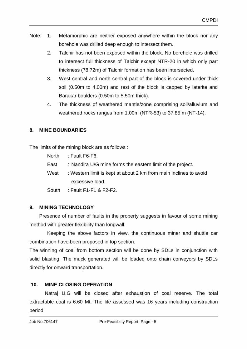
8. MINE BOUNDARIES
The limits of the mining block are as follows :
North : Fault F6-F6.
East : Nandira U/G mine forms the eastern limit of the project.
West : Western limit is kept at about 2 km from main inclines to avoid
excessive load.
South : Fault F1-F1 & F2-F2.
9. MINING TECHNOLOGY
Presence of number of faults in the property suggests in favour of some mining
method with greater flexibility than longwall.
Keeping the above factors in view, the continuous miner and shuttle car
combination have been proposed in top section.
The winning of coal from bottom section will be done by SDLs in conjunction with
solid blasting. The muck generated will be loaded onto chain conveyors by SDLs
directly for onward transportation.
10. MINE CLOSING OPERATION
Natraj U.G will be closed after exhaustion of coal reserve. The total
extractable coal is 6.60 Mt. The life assessed was 16 years including construction
period.

CMPDI
Job No.706147 Pre-Feasibilty Report, Page - 6
11. TARGETED OUTPUT, LIFE, RESERVE, PRODUCTION AND DUMPING
SCHEDULE
The proposed project has been planned for a production capacity of 0.64 Mt
per annum.
The project will sustain a mine life for a period of 16 years of mining
operations as on 01/09/18.
Coal is to be mined at the rate 0.64 MTY out of the available coal reserves
of 6.60 Million Tones (as on 01/09/18).
Year Coal in Mty
IV Year 0.26
V Year 0.48
VI Year 0.64
VII Year 0.64
VIII Year 0.64
IX Year 0.64
X Year 0.64
XI Year 0.64
XII Year 0.64
XIV Year 0.64
XV Year 0.64
XVI Year 0.10
Total 6.60
14. LAND REQUIREMENT
a. Details of land are given below. (Area in Ha)
Sl. No. Particulars Existing 0.64 Mty
1. Forest 217.19
2. Non-forest 79.28
Mining lease area 296.47
3. Residential colony 8.043
Total land 304.513

CMPDI
Job No.706147 Pre-Feasibilty Report, Page - 7
b. Break-up of land involved : (Area in Ha)
Pre-Mining:
*
T
h
e
r
e
was some mistake in arithmetic calculation in non-forest land for which the
actual land was reduced from 483.227 to 386.68 Ha
Pre-Mining:
S.No. LAND USE Actual Land
Transferred to Nandira U/G
Total in Ha
1 Agricultural land 70.53 17.58 52.95
2 Forest land 289.82 72.63 217.19
3 Waste land/Govt. land
18.33 -- 18.33
4 Grazing land - -- -
5 Surface water bodies
-- -- --
6 Settlements 8 -- 8
7 Others (specify) - -- -
Total Mine Lease 386.68 90.21 296.47
As per EMP
Actual Land After Correction
Transferred to Nandira U/G
Total
Forest 289.856 289.82 72.63 217.19
Non-Forest 193.371 *96.86 17.58 79.28
Total 483.227 386.68 90.21 296.47
Surface Infrastructure (outside mine lease area)
8.043 8.043 0.00 0.00
Total 491.27 394.723 90.21 296.47
CMPDI
Job No.706147 Pre-Feasibilty Report, Page - 8
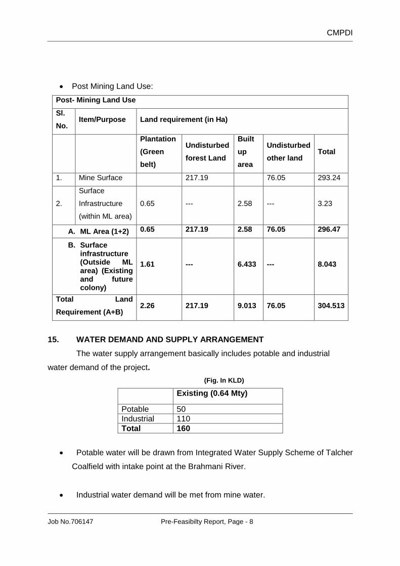
Post Mining Land Use:
Post- Mining Land Use
Sl.
No. Item/Purpose Land requirement (in Ha)
Plantation
(Green
belt)
Undisturbed
forest Land
Built
up
area
Undisturbed
other land Total
1. Mine Surface 217.19 76.05 293.24
2.
Surface
Infrastructure
(within ML area)
0.65 --- 2.58 --- 3.23
A. ML Area (1+2) 0.65 217.19 2.58 76.05 296.47
B. Surface infrastructure (Outside ML area) (Existing and future colony)
1.61 --- 6.433 --- 8.043
Total Land
Requirement (A+B) 2.26 217.19 9.013 76.05 304.513
15. WATER DEMAND AND SUPPLY ARRANGEMENT
The water supply arrangement basically includes potable and industrial
water demand of the project.
(Fig. In KLD)
Existing (0.64 Mty)
Potable 50
Industrial 110
Total 160
Potable water will be drawn from Integrated Water Supply Scheme of Talcher
Coalfield with intake point at the Brahmani River.
Industrial water demand will be met from mine water.

CMPDI
Job No.706147 Pre-Feasibilty Report, Page - 9
16. PUMPING AND DRAINAGE
The project lies adjacent to existing Nandira U/G mines (0.33 Mty), on the
western side. The topography of the area is fairly undulating with seasonal streams
here & there. In general there is gentle slope from south to north. The water pumped
out from the mine shall be connected to existing drainage system of the Nandira U/G
mine.
17. MINED OUT LAND & PROPOSED FINAL LAND USE
The land-use due to underground mining is disturbed mainly due to
construction of the surface facilities, e.g., shaft complexes, incline complexes, coal
handling plants, coal washeries, roads, railway sidings, etc. and also due to damage
to the land due to subsidence.
Subsidence prediction study will be carried out for this project. So there will
be no safety and fire hazards for the neighboring community after the mine closure.
Using the predicted subsidence movement, the impacts on the surface properties
and the surface drainage system will be determined. Also, possibilities of the
development of the cracks and their likely width will be predicted.
Capping of the shaft and incline or any other opening of the mine will be
effectively sealed so that illegal mining from these openings and safety hazards due
to fire and water, are prevented in the abandoned mine.
If the infrastructure is dismantled and the land is restored to some useful
purpose, the alternate land-use will be decided considering the conditions prevailing
during the period 5 years in advance of the closure of the mine.
18. MANPOWER
Proposed manpower is 715.
Sl. No. Particulars Strength
1 Executives 40
2 Monthly rated 98
3 Daily rated 577
Total : 715

CMPDI
Job No.706147 Pre-Feasibilty Report, Page - 10
19. POWER SUPPLY
The annual energy requirement for the project is 12.49 MkWh.
The power supply to the project will come from 132/33 kV Central Sub-station
of MCL at Nandira.
20. COAL HANDLING & DESPATCH ARRANGEMENT
Besides the local demand, coal from this coalfield are being transported
by rail route or coastal Shipping via Paradip port to costal power stations of southern
India.
(a) Basic Parameters
(i) Target output of the mine : 0.64 MTPA
(ii) Life of the mine (excluding : 16 years
construction period)
(iii) Mine operation (production) : 3 shifts/day
(iv) CHP operation : 3 shifts/day
(v) Quality of coal : Grade C to D long flame
(vi) Product size : (-) 75 mm
(vii) Customer : Sponge Iron Plants/ Local industry &
basket linkage.
(viii) No. of overhead bunkers : 2x300t
& capacity
(b) Washing
Washing of coal is not proposed in approved project.
21. INFRASTRUCTURE DETAILS
CHP
The targeted production of the mine is 0.64 Mty. Coal brought from U/G mine
shall be handled separately for top and bottom sections. In addition to the above,
provision for ground stacking has also been made by feeding the coal directly from
the shuttle conveyor onto a belt conveyor. Coal shall be taken for blending to sites in

CMPDI
Job No.706147 Pre-Feasibilty Report, Page - 11
opencast mines, if required. Final dispatch arrangements from CHP shall be decided
by MCL based on the linkage pattern.
WORKSHOP
The existing Nandira U/G mine has a full-fledged unit workshop and it is
envisaged that all the existing facilities shall be extended to Natraj U/G mine also.
RAILWAY SIDINGS
Coal shall be taken for blending to sites in opencast mines, if required. Final
dispatch arrangements from CHP shall be decided by MCL based on the linkage
pattern.
22. ENVIRONMENTAL MONITORING
Routine Environment monitoring will be done for the project. For air, water
and noise pollution control measures, the samples will be collected and tested round
the year with appropriate frequency at strategic places.
23. SUBSIDENCE MANAGEMENT
Attempt has been made to minimize the land requirement for the project. The
cracks are likely to be formed in the tension zones, which require plugging by dozing.
However, because of sub-soil thickness of 2 to 2.5 m, proper drainage will be
maintained. This will minimize the water accumulation in the depressed zone also.
Because of strain development near the panel barrier, the trees may be uprooted.
This requires strengthening of tree cover for which provision will be made in the
revenue cost of the project.
Cracks formed and reaching to the surface, shall be plugged as per standard
procedure.
CMPDI
Job No.706147 Pre-Feasibilty Report, Page - 12
24. SAFETY AND SECURITY ARRANGEMENT
The inclines & shafts will be effectively sealed so that illegal mining from
these openings and safety hazards due to fire and water, are prevented in the
abandoned mine. The area around the mine shall be fenced and shall be guarded.
The land which may be damaged due to subsidence after depillaring, if any,
will be properly restored with adoption of sound subsidence management. The land
which will be subsided, will be restored by filling up soils/sands with proper leveling
and grading. The land on the surface may be affected slightly due to subsidence after
depillaring. Measures will be taken to strengthen this land. The damage if any will be
made up by filing the cracks properly and then by fresh plantation.
Adequate provision will be made for lighting the installations near strategic
places by 2x250W HPSV lamps.
25. REHABILITATION AND RESETTLEMENT
No village habitation is located on the surface of this mine. So resettlement
and rehabilitation for displaced families are not necessary. However, the land loser
families will be given suitable compensation.