PRE-FEASIBILITY ENVIRONMENTAL IMPACT ASSESSMENTdocuments.worldbank.org/curated/en/...PRE-FEASIBILITY...
100
PRE-FEASIBILITY ENVIRONMENTAL IMPACT ASSESSMENT KOSOVO ENERGY SECTOR CLEAN-UP AND LAND RECLAMATION PROJECT FINAL DRAFT MAY 2, 2006 E1395 Vol. 2 Public Disclosure Authorized Public Disclosure Authorized Public Disclosure Authorized Public Disclosure Authorized Public Disclosure Authorized Public Disclosure Authorized Public Disclosure Authorized Public Disclosure Authorized
Transcript of PRE-FEASIBILITY ENVIRONMENTAL IMPACT ASSESSMENTdocuments.worldbank.org/curated/en/...PRE-FEASIBILITY...

PPRREE--FFEEAASSIIBBIILLIITTYY EENNVVIIRROONNMMEENNTTAALL IIMMPPAACCTT
AASSSSEESSSSMMEENNTT
KKOOSSOOVVOO EENNEERRGGYY SSEECCTTOORR CCLLEEAANN--UUPP AANNDD LLAANNDD
RREECCLLAAMMAATTIIOONN PPRROOJJEECCTT
FFIINNAALL DDRRAAFFTT MMAAYY 22,, 22000066
E1395Vol. 2
Pub
lic D
iscl
osur
e A
utho
rized
Pub
lic D
iscl
osur
e A
utho
rized
Pub
lic D
iscl
osur
e A
utho
rized
Pub
lic D
iscl
osur
e A
utho
rized
Pub
lic D
iscl
osur
e A
utho
rized
Pub
lic D
iscl
osur
e A
utho
rized
Pub
lic D
iscl
osur
e A
utho
rized
Pub
lic D
iscl
osur
e A
utho
rized

Draft EIA
Preliminary Environmental Assessment 2
TABLE OF CONTENTS
EXECUTIVE SUMMARY ..................................................................................... 5
BACKGROUND ........................................................................................................................................... 5
REASONS FOR PROJECT CLASSIFICATION ..................................................................................... 7
ENVIRONMENTAL BASELINE CONDITIONS .................................................................................... 8
ALTERNATIVES CONSIDERED ............................................................................................................. 9
PREDICTED IMPACTS OF THE CHOSEN ALTERNATIVES/PROJECT COMPONENTS ........ 10
SUMMARY OF THE ENVIRONMENTAL MANAGEMENT PLAN ................................................. 11
CONSULTATION WITH AFFECTED GROUPS AND LOCAL NGOs.............................................. 12
COMPLIANCE WITH WORLD BANK SAFEGUARDS...................................................................... 12
ENVIRONMENT-RELATED LOAN CONDITIONALITIES AND COVENANTS........................... 12
1.0 POLICY, LEGAL AND ADMINISTRATIVE FRAMEWORK......................... 13
1.1 KOSOVO LAWS, REGULATIONS and INSTITUTIONAL ASPECTS........................................ 13
1.2 REQUIREMENTS OF THE WORLD BANK................................................................................... 16
2.0 PROJECT DESCRIPTION........................................................................... 17
2.1 BACKGROUND ................................................................................................................................ 17
2.2 OBJECTIVES ................................................................................................................................... 19
2.3 PROJECT COMPONENTS.................................................................................................................. 20
2.4 PROJECT SITE OVERVIEW............................................................................................................. 20
3.0 BASELINE DATA ........................................................................................ 29
3.1. NATURAL SYSTEMS DESCRIPTION ....................................................... 29 3.1.1. Landscape........................................................................................................ 29 3.1.2. Ecology (Vegetation, Fauna)........................................................................... 30 3.1.3. Climate conditions and Air quality ................................................................. 31 3.1.4. Noise................................................................................................................ 35 3.1.5. Soil .................................................................................................................. 36 3.1.6. Hydrogeological situation ............................................................................... 37 3.1.7. Surface waters ................................................................................................. 39
3.2. Environmental Pollution ..................................................................................................................... 42

Draft EIA
Preliminary Environmental Assessment 3
3.3. Socio-economic data (Human Beings) ................................................................................................ 50
4.0 ENVIRONMENTAL IMPACTS..................................................................... 51
5.0 ANALYSIS OF ALTERNATIVES................................................................. 71
6.0 ENVIRONMENTAL MANAGEMENT PLAN ........................................... 75
6.1 Mitigation Strategy....................................................................................................................... 75
6.2 Monitoring Strategy ..................................................................................................................... 78
6.3 Content of the Site Monitoring Plan ........................................................................................... 80
6.4 Monitoring Plan .................................................................................................................................... 89
6.5. Institutional Arrangements for EMP Implementation..................................................................... 92
6.6. Project Operation and maintenance .................................................................................................. 93
6.7. Costs affiliated with implementation of the project EMP ................................................................ 94
Appendix........................................................................................................Results of the PublicHearings

Draft EIA
Preliminary Environmental Assessment 4
L i s t o f Ab b r e v i a t i o n s :
ASF Ash Storage Facility (Synonyms “Ash Dump”, “Ash Hill”, “Ash Deposit”)
BAT Best Available Techniques BREF Best Reference Document [EU] BWE Bucket Wheel Excavator CB Conveyor Belt CLRP Clean-Up and Land Reclamation Project CPT Cone Penetration Test DGIS Directorate for International Cooperation, Foreign Ministry
of the Netherlands EAR European Agency for Reconstruction EIA Environmental Impact Assessment FS Feasibility Study GW Groundwater HHS Human Health and Safety ICMM [Kosovar] Independent Commission on Mines and Minerals INKOS Technical site nvestigation company formerly associated with
KEK, now nominally independent KEK Kosovo Energy Corporation (Korporata Energjetike e Kosoves) LPI Lignite Power Initiative MAC Maximum Allowed Concentration (values) MEM Ministry for Energy and Mining MESP Ministry for Environment and Spatial Planning MWTR Management of Tailings and Waste Rock [EU BREF Document] N, E, S, W North, South, East, West and combinations (SW = southwest) OPM Open Pit Mine PID [The World Bank’s] Project Information Document PM Person Months PMU Project Management Unit SC Selection Criteria SF Factor of Safety SI Site Investigations SPT Standard Penetration Test TOR Terms of Reference TPP Thermal Power Plant UNMIK United Nations Mission in Kosovo
Draft EIA
Preliminary Environmental Assessment 5
EXECUTIVE SUMMARY
BACKGROUND The environmental status of Kosovo is dominated by a range of issues including polluted air, land and water and poor infrastructure management generated mostly by the lack of an environmental protection regime in the past. The historical legacy of contamination poses a serious health risk due to the environmental pollution from lead, cadmium, zinc, and copper in the surroundings, mostly from the mining sector and particularly in the river Sitnica which, after flowing in the Iber river, follows its route up to the Danube and into the Black Sea. The uncontrolled development in both the industrial and urban sectors as well as a continuing lack of effective regulation of activities such as unrestricted construction works has enhanced the environmental protection problems. Overall, the public health along with the environment is mostly threatened by industrial complexes activities, power plants and mining operations and the lack of sewage and effluent treatment plants. The heavy pollution in “hot spots” concentrated in large industrial areas such as the coal-powered thermo-electric facilities near Prishtina and the large mining industrial complex in the Mitrovica area is a major environmental and social issue in Kosovo. Although coal is of major significance for Kosovo as it provides direct and indirect employment for thousands of people in the coal mining and electricity generation industry it also has a great impact on the surrounding urban areas which additionally suffer from poor infrastructure and lack of municipal services with a significant difference between Prishtina and, for example, the outlying towns such as Lipjan. Arguably, the highest impact from coal-fired power generation in Kosovo on public health is caused by exposure to unfiltered dust emissions from Kosovo A power station stacks and dust coming from the dry ash dumping from the same Kosovo A power station. Kosovo B power station has dust filters installed to treat flue gases and ashes are disposed of in a wet manner causing less dust problems. Due to the lack of treatment of industrial wastewaters, power plants also cause water pollution. The review of the impact of lignite mining operations in Kosovo on the environment has been recently carried out considering past damages and future effects. Measures to minimize the future effects of the mining like dust and noise emissions, water pollution and resettlements have been planned by the local Government. With respect to the past damages, two main areas of concern have been identified, the re-cultivation of the old overburden dumps and the extinguishing of smoldering mine fires. Special attention must be paid to the mine fires, which cause environmental problems (air pollution), safety problems in the mines and an economic damage on the mine deposits. Additional problems are the ash dumps containing more than 40 million tons of ash occupy about 150 ha of land, as well as the pits created during the coal extraction in the lignite open pit mines. Furthermore, the social pressures from the growing population and
Draft EIA
Preliminary Environmental Assessment 6
poverty levels are also putting a strain on large and valuable protected areas accentuating the environmental degradation throughout Kosovo. Assisted by the World Bank and other donors, the government administration of Kosovo is preparing a comprehensive program for energy sector development in Kosovo. It supports (environmentally) sustainable private sector-led development of Kosovo’s lignite resources and power generation capacity. The program also includes measures to address the main environmental issues related to the current lignite mining and power generation operations in Kosovo. This strategy intends to focus on the decrease of environmental degradation due to inadequate mining operations and to improve the environmental performance of the thermal power stations in the area, which are a major concern for public health and the environment and form an obstacle in attracting high-quality investors for future and sustainable development of this sector. In this regard, KEK and the government of Kosovo are preparing in collaboration with the World Bank the Kosovo Energy Sector Clean-up and Land Reclamation Project (the Project or CLRP) that aims at reversing some of the environmental problems caused in the past and bring some good environmental practices to future operations to meet local and regional power demands. The proposed Project (CLRP) involves the execution of a clean-up and reclamation pilot project in the area of Obiliq about 3 km NW from Prishtina where current lignite mining operations take place and the power stations Kosovo A and B are located. Kosovo A plant is generating limited output and needs substantial investments in equipment and environmental control measures to be able to contribute to Kosovo’s power generation basis for the coming years while Kosovo B has been the subject of major investments to upgrade environmental and operational performance. The Project main objective is to deal with high priority environmental issues related to Kosovo A ash dump sites rehabilitation, reclaim land currently occupied by overburden dumps from the existing mines and, if addition funding is found, possibly the removal of hazardous chemicals improperly stored at the abandoned coal gasification plant in the area. The activities to be financed by the Project include the following main actions: (i) Preparation of the Mirash Open Pit Mine for Ash Management; (ii) Relocation of Kosovo A Ash Dumps into Mirash Open Pit Mine; and (iii) Reclamation of Overburden Dump Areas. Furthermore, the preparation studies acknowledged the need to remediate the area of a former gasification plant where currently hazardous chemical such as phenols and other by-products from coal gasification are deposited in a manner that cause a risk for the environmental and health of local population. The proposed Project includes the option to manage and possibly to dispose of these hazardous chemicals if additional funding is offered by other donors.
Draft EIA
Preliminary Environmental Assessment 7
REASONS FOR PROJECT CLASSIFICATION The proposed project’s primary objectives are to stop the open disposal of ashes from the Kosovo A power station, the environmental restoration of the Kosovo A ash dumps near Obliq and land reclamation of areas currently occupied by overburden dumps from the existing mines, as a necessary step in assuring safe environment and agriculture for humans in the area. Despite the fact that the project is designed to mitigate negative environmental impacts and improve the environmental situation, at the start of preparations the project received a Category A rating in line with the World Bank’s Policy on Environmental Assessment (OP 4.01). This was decided since, as the project will demonstrate post-mining clean-up and land reclamation, this activity could include soil contaminated by hazardous residues from an old gasification plant or the removal of hazardous chemicals currently stored at the site of this gasification plant. There is a possibility that phenols have been discharged to the field below the ash dumps that will be removed. An investigation of samples from a drilling test, executed during the preparation of the pre-feasibility EIA, suggests that phenol discharges to the underground did not take place at a large scale. Since the presence of phenols cannot be excluded completely at this stage it was decided to maintain the Category A rating of the project. As a consequence the project and the prepared EIA/EMP were discussed in two consultation rounds in the Municipality of Obiliq / Obilic and that during the design stage of project implementation, detailed environmental site investigation and a detailed EIA and EMPs will be prepared. The main potential environmental impacts are affiliated with the cleanup of the former gasification plant site, namely the management and possible disposal of hazardous chemicals by packaging and transporting to incineration of about 13,000 m3 of phenol, benzene and other coal gasification affiliated organic materials. However, these activities will be supported only, if additional donor funding becomes available. In this case the Clean-up and Land Reclamation Project may be extended to include the re-packaging and removal for safe disposal of the hazardous chemicals and a detailed environmental assessment will be conducted prior to a decision on the implementation.
Draft EIA
Preliminary Environmental Assessment 8
ENVIRONMENTAL BASELINE CONDITIONS
Several studies of general description of the Obiliq mining site pollution have been developed during the last few years but there is not yet sufficient quantitative information available to support final conclusions on the contamination situation in terms of the physical and chemical extent of the contaminated zone, properties and concentrations of main contaminants, and the amount of contaminated materials in soil, groundwater and surface water. The environmental (treatment) installations are from the time the units were erected, badly maintained and with insufficient capacity considering the higher quantities of fuel currently used. The dust pollutes soil and water courses, but primarily is considered the source of health problems and illnesses in the human population. Although no formal health studies to quantify the specific effects attributable to the ash tips have yet been undertaken, evidence suggest the problems are extremely widespread including recorded deaths of cancers of the respiratory system of individuals living in the immediate vicinity of the tip. From the available information collected from the Institute of Mines and INKOS the proposed sequence for geology in the vicinity of the tipping area and project site would appear to comprise of mainly silty clays overlying a sequence of brown coals and clays with high impermeability. The groundwater flow would be expected to follow the east to west trend towards the river. A quantity of soft compressible overburden material, comprised of saturated silty clays and topsoil was placed at least in part, in the area currently occupied by the Western Tip, where there is evidence of slope failure and tip movement. No detailed monitoring data was available to determine the impact on soil and surface waters from the solid ash tips. Several drillings recently performed in the middle of the Western Tip of Kosovo A Ash Dump suggested elevated concentration of cadmium (above the maximum allowed standard value for ash) while phenol and PAH were within the acceptable limits. These results as well as the given structure of the soil (ash layer on top of overburden clay and coal layers at low permeability) allow the conclusion that contamination of groundwater from phenols and PAHs is unlikely. Furthermore, the alkaline content of the ash/clay samples prevents dissemination of the organic materials in groundwater if these would ever reach this depth. However, further detailed sampling is strongly recommended for final conclusions over the presence or absence and migration of pollutants in the underground below the ash dumps. The current potential hazardous materials stored on the gasification site including about 15,000 m3 of hazardous waste (e.g., TAR (1,000m3); Heavy Tar (500m3); medium oils (1,000m3); Ammonium Hydroxide (1,000m3); benzene (500m3); polluted oil (250m3); phenol mixed with water (13,000 m3); concentrated phenol (750 m3) is significantly high. There is no knowledge of the pollution of the groundwater or soil surrounding this gasification plant.

Draft EIA
Preliminary Environmental Assessment 9
Some uncertainties that remain concerning the presence of contamination at the project site stress the importance of careful investigations prior to the remediation works and the preparedness to take into account in working procedures the possibility of phenol contamination in the underground that could be encountered during cleanup operations. A detailed EIA will be conducted at the design stage of project implementation and prior to the commencement of works to investigate environmental conditions and define measures regarding geology, hydrogeology, geotechnical properties and stability and the chemical composition and properties of potential hazardous materials, seepage water and groundwater which will allow the finalization of a category A project baseline data. The geotechnical characteristics of the in-situ overburden, the tipped mine overburden, and the ash within the tip need to be fully established as well as a formal geotechnical site investigation, including detailed sampling and monitoring program.
ALTERNATIVES CONSIDERED The pre-feasibility EIA identifies and evaluates several alternatives to the proposed project, including the no action alternative; alternative ways of decreasing the environmental pollution at the site through rehabilitation of the Kosovo B waste water treatment plant; several cleanup technology alternatives, including in situ remediation of the Kosovo A and B ash storage facilities and complete removal of Kosovo B ASF;alternative off-site storage/disposal and management of hazardous waste. Postponement of the project and the do-nothing scenario to wait for capacity building within KEK and Kosovo’s regulatory authorities were rejected for the Kosovo A disposal component. These options would neglect the urgent demands of stakeholders. They would also allow continuation of the current high impact related dust problems, including public health and safety issues and landscape pollution. If only the ongoing ash disposal would be stopped, environmental impacts would improve but there would still be continuous dust problems (including resulting health problems) due to the existing ash dump. For the reclamation of the overburden dump areas, project postponement and the do-nothing scenario were rejected since the benefit/cost ratio is so advantageous and land is a scarce commodity in Kosovo. Furthermore in terms of development of the entire energy sector and the future development of the new Sibovc mine, having land available for resettlement purposes is crucial for proper development of the mining sector. The rehabilitation of the wastewater treatment plant is not the optimum solution. The plant poses no significant environmental risk to justify major interventions. There is no significant area of reclaimed land, and its vicinity to Kosovo B does not allow for any subsequent utilization scenario. Furthermore the work would yield a relatively low positive environmental impact, hence the rehabilitation of the wastewater treatment plant was not incorporated in the final project components.

Draft EIA
Preliminary Environmental Assessment 10
Reshaping of the Kosovo A ash dump instead of its full removal was considered but rejected. The costs of the two options are in the same order of magnitude but the full removal of the ash dump has the advantage as it is a long-term solution to the problem, and materials from the reshaping are also applied to reclaim part of the Mirash mine. If the reshaping option would be implemented, less land would be reclaimed and it would hinder future development of the lignite D Field deposits underneath the dump. KEK is implementing a project to stop Kosovo B ash disposal at the Kosovo B open ash dump and redirect ash transport to a dedicated section in the Mirash mine. Ashes from Kosovo B are transported and disposed of as slurry, therefore, the geotechnical stability of the Kosovo B Ash Dump is better and the surface is hard and cemented, causing much less dust problems. In addition the cemented ash is harder to remove, transport and handle than the soft ash from the Kosovo A Ash Dump. In view of the limited financial resources, only the removal of the Kosovo A Ash Dump has been included in the CLRP. Based on the successful completion of the removal of the Kosovo A Ash Dump, KEK would consider mobilizing resources for the removal of the Kosovo B Ash Dump.
PREDICTED IMPACTS OF THE CHOSEN ALTERNATIVES/PROJECT COMPONENTS The pre-feasibility EIA confirms that the activities to be considered under the Project involve the following actions: (i) preparation of the Mirash Open Pit Mine for Ash Management; (ii) relocation of Kosovo A Ash Dumps into Mirash Open Pit Mine; and (iii) Reclamation of Overburden Dump Areas. If additional funding is available from other donors the Project will consider to implement the management of phenols and other hazardous waste located at the gasification plant through packing and transporting them outside Kosovo. Predicted environmental impacts of the chosen activities are related mostly to construction works performed during the proposed activities and to the transport of hazardous materials from the gasification plant for incineration if this activity would be included in the project. Effects could be encountered through generation of dust and noise. Mitigation measures for such effects have been analyzed and proposed to be implemented during the execution of the project. Furthermore, monitoring of the water groundwater soil air and noise pollution would be performed during construction works period as well as once the works have stopped. A summary of the environmental management plan is presented below.

Draft EIA
Preliminary Environmental Assessment 11
SUMMARY OF THE ENVIRONMENTAL MANAGEMENT PLAN The EMP provides a thorough presentation on mitigation measures applicable to the stages of clean-up and land reclamation components likely to be recommended in the final EIA. These include:
• Site management and institutional controls - limiting access to clean-up sites and restricting land and water uses where appropriate.
• Health and safety protection for clean-up workers and nearby residents - air monitoring, personnel training, use of personal protective equipment, decontamination of equipment, communications.
• Contingency planning and emergency response - on-site emergency response, community emergency response, incident reporting, practicing responses, first aid procedures and equipment, training, spill control plan.
• Mitigation measures for removing hazardous wastes/phenols (in case of their presence in Kosovo A Ash dump) - recommended techniques.
• Soil removal mitigation measures - timing of operations to avoid wet weather, flooding and high winds; covering of excavation areas and stockpiled soils to prevent dispersion and dust emissions and rain erosion, underlining of soil stockpiles to prevent leaching to clean soil and groundwater, installation of ridges and ditches to control surface water run-on and run-off.
• Soil transport mitigation measures - waste characterization and labeling, safe loading and unloading, wetting wastes and covering trucks to prevent dust generation, emergency response.
The EMP also summarizes a series of environmental monitoring programs, aimed at measuring contamination in air, soil, surface water, sediments, ground water, drinking water, fish, crops, livestock, and humans before, during and after clean-up. Monitoring parameters, locations, frequencies and methods are provided for each clean-up program activity. Institutional arrangements and costs for implementing the mitigation and monitoring are also provided. Implementation will be accomplished primarily through a project management structure within KEK and supported by staff of relevant government agencies seconded to the project and domestic and international consultants as needed.

Draft EIA
Preliminary Environmental Assessment 12
CONSULTATION WITH AFFECTED GROUPS AND LOCAL NGOs A public consultation process has been implemented for the proposed Project; initial public meetings were held in early April 2006 at the project site in Obiliq; a final public meeting was held in late April 2006 based on the Draft pre-feasibility EIA report.
COMPLIANCE WITH WORLD BANK SAFEGUARDS The pre-feasibility EIA has been prepared and submitted in compliance with all applicable World Bank Safeguard Policies relating to EIAs. The overall EIA complies with the Environmental Assessment safeguard policy (OP4.01). The Dam Safety safeguard policy (OP4.37) is not triggered since the proposed project will not involve remediation of wet mine tailings or wet ash disposal. The Pest Management (OP4.09), Natural habitats (OP4.04), Cultural property (OP 4.11), Forestry (OP4.36), Indigenous Peoples (OD4.20), Involuntary Resettlement (OP4.12), and Projects on International Waterways (OP7.50) are not triggered.
ENVIRONMENT-RELATED LOAN CONDITIONALITIES AND COVENANTS Environmental loan conditionalities and covenants will relate to the implementation of recommended mitigation, monitoring and capacity building measures. During the design stage of project implementation, detailed environmental site investigation and a detailed EIA and EMPs will be prepared and submitted to the Association. Respective covenants on the EIA and EMPs have been integrated in the Financing Agreement.
Draft EIA
Preliminary Environmental Assessment 13
1.0 POLICY, LEGAL AND ADMINISTRATIVE FRAMEWORK This section outlines the EIA-related laws and regulations of the Assembly of Kosovo and the World Bank. Other laws and regulations may be mentioned in the following sections where relevant to discussion of the project’s environmental impacts. It is beyond the scope of this EIA, however, to provide a full identification and analysis of all laws and regulations that may relate to the hazardous waste management. Section 1.1 discusses Kosovo’s EIA laws and regulations while Section 1.2 covers the World Bank's EIA policies and procedures.
1.1 KOSOVO LAWS, REGULATIONS and INSTITUTIONAL ASPECTS The Kosovo State of the Environment Report (April, 2003) highlights a range of issues including polluted air, land and water and poor infrastructure management. There are threats to public health from industrial complexes, power plants, mining operations and the lack of sewage and effluent treatment plant. The draft Environmental Strategy for Kosovo1 identifies a number of characteristics of Kosovar society that include political uncertainty, the low level of economic activity and employment, and poverty as concerns that are relevant to environmental management. The government has a policy of association with the EU, leading eventually to membership. It is thus seeking harmonisation of its laws with the EU environmental acquis communautaire. This principle is established in the constitutional framework and in the Law on Environmental Protection; the actual implementation of the principle, however, was and to a certain extent still is hampered by insufficient understanding of the principles, procedures and terminology of European Community Law. An overview of the main relevant legislation is given below: • The Law on Environmental Protection adopted by the Assembly of Kosovo on 6 January 2003 (Regulation No. 2003/9) highlights the need to bring environmental standards in Kosovo into harmony with those of the European Union; Article 7 of this law stipulates that every five years the Minister should submit to the Government a proposed Kosovo Environmental protection program including a cost benefit assessment of measures triggering: (a) Promoting an integrated system of Environmental Protection and the promotion of sustainable economic development; (b) Improvements in environmental planning and adjustments; (c) Protection of water; (d) Protection of soil; (e) Protection of air and atmosphere (including ozone); (f) Protection of bio-diversity. Ecosystems and Nature Protection areas; (g) Regulation of activities involving Hazardous Waste and dangerous chemicals; and (h) Protection from noise and vibration. Article 12 presents rules of operation in relation to waste and hazardous substances including their
1 MESP draft, 20 July 2004

Draft EIA
Preliminary Environmental Assessment 14
(i) collection, classification, storage and transportation; (ii) accumulation, destruction and/or treatment; (iii) recycling, composting, and other methods of reusing waste; and (iv) use as energy-producing materials and raw materials. Article 14 stipulates that through this law the Minister will issue warnings, recommendations and protection measures if pollution exceeds critical limit levels for solid, liquid, gaseous pollutants and hazardous substances into the air, water and soil. Furthermore, the law presents the EIA procedure and the environmental consent including description of environmental operational permit procedures, environmental authorization (Articles 20 – 23).
This law also stipulates limits for air, soil, water, noise and natural resources protection. This Law also calls for the establishment of the Kosovo Environment Fund.
• The Law on Air Protection (Law No. 2004/30), among other issues addresses the basic environmental indicators and standards of air quality, the limits for discharges into the air, the obligations of the operators of mobile pollution sources, the obtaining of environmental permits for activities that pollute the air, and responsibilities for air quality monitoring, including sanctions for air polluters.
• The Law on Spatial Planning, promulgated 10th September 2003, (UNMIK /REG/2003/30). Application for planning permission and the relevant application documents will be submitted to the Ministry of Environment and Spatial Planning in line with applicable Kosovo Spatial Planning Law. Planning application will include full comprehensive EIA and complete design of project scheme
• The Law on Mining and Geological Restoration suggests that the Government plays a key role in helping to provide for reclamation of lands disturbed by coal mining, which can restore large tracts of land from an unsafe, derelict state to a productive state that can benefit the community. Under this law the government acts as promoter of the resources to the private sector, maintains geoscience database and resident expertise in matters related to coal geoscience, manages the exploration, development of mining under a system of licenses and leases, and collects royalties on coal production.
Additional current laws relevant to the project are: 1. Law adopted on Occupational Safety, Health and Working Environment, promulgated
6th November 2003, (UNMIK /ADMINISTRATIVE DIRECTIVE/2003/33). 2. The Kosovo Water Law (Law No. 2004.24) 3. The Waste Management Law is approved by the Government, but currently awaiting
approval by the Parliament. 4. The Law on Energy which defines the general principles of the energy strategy in
Kosovo and rules for the sustainable energy supply and its efficient use, as well as for the exploitation of renewable energy source. It also determines the measures for the operational activities in the sector.
5. Establishment of Administrative Department of Environmental Protection, (REGULATION 2000/32)
Draft EIA
Preliminary Environmental Assessment 15
In addition to the above laws, there are corresponding implementing regulations dealing with EIA. The Administrative Directive No 9/2004 defines and specifies procedures for identification, evaluation, reporting and management of environmental impacts of a proposed project. The law establishes that a proponent is responsible for carrying out an EIA, which is a mandatory part of a project deign documentation, and related information dissemination and public participation. An EIA must include a) an assessment of types and magnitude of environmental impacts and risks, b) a forecast environmental changes due to the proposed activity and c) environmental protection measures to ensure compliance with all legal requirements. An EIA should also evaluate impacts on human health due to environmental change. Among other issues, the Directive No.9/2004 provides (i) Descriptions of the EIA process and status, phases or levels, and duties and responsibilities of EIA process participants; (ii) Scopes of EIA materials and contents of EIA documents required to be submitted at the different levels (environmental review, preliminary environmental assessment, and final environmental assessment); and (iii) list of type of projects for which a full or simplified EIA is required (Annex I and II). Technical assistance has been recently provided by EuropeAid through CARDS program to support institutional strengthening for Environmental Management to the Ministry of Environment and Spatial Planning (MESP) of Kosovo. The project aimed to define and establish the strategies, policies, concepts, procedures, and capacities required for managing, implementing and enforcing environmental policy in Kosovo. This included strengthening environmental management and training officials and key staff, as well as supplying equipment and logistical support for targeted sectors such as environmental monitoring and data management. The responsible institutions for environmental protection are the Ministry of Environment and Spatial Planning (MESP) and Kosovo Environmental Protection Agency (KEPA). The role of the Ministry is in decision making related to policy and strategy formulation in environment and protected areas, environmental permitting and law drafting and enforcement. KEPA is in charge of pollution control and monitoring, preparation of environmental information system and undertaking of research. There are three agencies within MESP that report directly to the Minister namely the Spatial Planning Institute, the Environmental Inspectorate (responsible for supervision and inspection) and KEPA (which includes the Kosovo Hydro-Meteorological Institute and the Institute for Nature and Environmental Protection). It should be noted that KEPA has been established under law but not yet as a physical entity. KEK the national power company that operates the existing mines and power stations is a state-owned enterprise. KEK will execute the Project operations including establishing a new unit with appropriate staff. The institute INKOS is the current environmental organisation which performs monitoring on the site for KEK. Although the legal framework is almost completed and several institutions are in place there is a huge need for strengthening the environmental institutions and improving

Draft EIA
Preliminary Environmental Assessment 16
enforcement and compliance with environmental regulations in Kosovo. The government structures are relatively weak and there is no clear division of roles and responsibilities between institutions in biodiversity conservation and environmental protection. Furthermore, the law enforcement is inadequate and there is no contemporary system in place for the management of historic and current pollution and management of protected areas. The European Agency for Reconstruction has provided considerable support to the strengthening of the MESP, as regards staff training, preparation of policies and strategies and laws
1.2 REQUIREMENTS OF THE WORLD BANK Environmental Assessment (EA) is one of the ten Safeguard Policies of the World Bank. EA is used in the World Bank to examine the environmental risks and benefits associated with Bank lending operations. The Bank’s environmental assessment procedures are described in OP/BP 4.01 (Operational Policy, Bank Procedures). The Bank’s policy underlines that EA should be thought of as a process rather than a specific product. Key considerations when in the EA process include: linkages with social assessments, analysis of alternatives, public participation and consultation with affected people and NGOs, and disclosure of information. Like economic, financial, institutional and engineering analysis, EA is part of project preparation and therefore is the borrower’s responsibility. The Bank undertakes environmental screening of each proposed project to determine the appropriate extent and type of EA. The Bank classifies the proposed project into one of four categories, depending on the type, location, sensitivity, and scale of the project and the nature and magnitude of its potential environmental impacts. According to classification of the World Bank based on Operational Directive 4.01, this project is determined as category "A" which means that it is likely to have significant adverse environmental impacts that are sensitive, diverse, or unprecedented. These impacts may affect an area broader than the sites or facilities subject to physical works. EA for a Category A project examines the project’s potential negative and positive environmental impacts, compares them with those of feasible alternatives (including the "without project" situation), and recommends any measures needed to prevent, minimize, mitigate, or compensate for adverse impacts and improve environmental performance. For a Category A project, the borrower is responsible for preparing a report, normally an EIA that includes an EMP. For all Category A projects proposed for IBRD or IDA financing, during the EA process, the borrower consults project-affected groups and local nongovernmental organizations (NGOs) about the project’s environmental aspects and takes their views into account. The borrower initiates such consultations as early as possible. The borrower consults these groups twice: (a) shortly after environmental screening and before the terms of reference for the EA are finalized; and (b) once a draft EA report is prepared. In addition, the
Draft EIA
Preliminary Environmental Assessment 17
borrower consults with such groups throughout project implementation as necessary to address EA-related issues that affect them. During project implementation, the borrower reports on: (a) compliance with measures agreed with the Bank on the basis of the findings and results of the EA, including implementation of any Draft Final EIA; for Kosovo Cleanup and Land Reclamation Project the EMP, as set out in the project documents; (b) the status of: mitigation measures; and (c) the findings of monitoring programs. The Bank bases supervision of the project’s environmental aspects on the findings and recommendations of the EA, including measures set out in the legal agreements, any EMP, and other project documents.
2.0 PROJECT DESCRIPTION
2.1 BACKGROUND
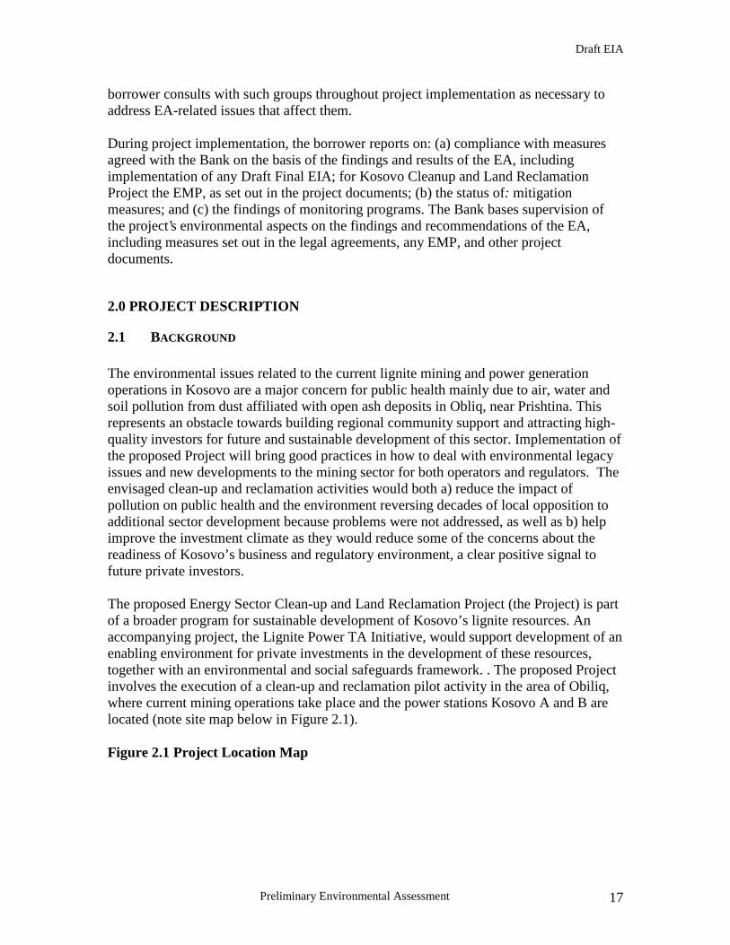
The environmental issues related to the current lignite mining and power generation operations in Kosovo are a major concern for public health mainly due to air, water and soil pollution from dust affiliated with open ash deposits in Obliq, near Prishtina. This represents an obstacle towards building regional community support and attracting high-quality investors for future and sustainable development of this sector. Implementation of the proposed Project will bring good practices in how to deal with environmental legacy issues and new developments to the mining sector for both operators and regulators. The envisaged clean-up and reclamation activities would both a) reduce the impact of pollution on public health and the environment reversing decades of local opposition to additional sector development because problems were not addressed, as well as b) help improve the investment climate as they would reduce some of the concerns about the readiness of Kosovo’s business and regulatory environment, a clear positive signal to future private investors. The proposed Energy Sector Clean-up and Land Reclamation Project (the Project) is part of a broader program for sustainable development of Kosovo’s lignite resources. An accompanying project, the Lignite Power TA Initiative, would support development of an enabling environment for private investments in the development of these resources, together with an environmental and social safeguards framework. . The proposed Project involves the execution of a clean-up and reclamation pilot activity in the area of Obiliq, where current mining operations take place and the power stations Kosovo A and B are located (note site map below in Figure 2.1). Figure 2.1 Project Location Map

Draft EIA
Preliminary Environmental Assessment 18
The two power plants, Kosovo A and Kosovo B, the affiliated mines and their ash disposal sites (Mirash and Bardh) are located in the municipality of Obliq, circa 8 km from the city of Pristina. Obilq is the major settlement with a population of circa. 33,000 people. The average altitude is approximately 550 m above sea level. The lignite exploitation in the area dates from 1920, and commenced with underground mining. The first surface mine was developed in 1959, in the Mirash area. There are two main rivers in the mining area, the Sitinica and the Drenica. Surface waters from the Mirash open pit are discharged in the river Sitnica, whereas surface waters from the Bardh open pit are discharged in the river Drenicia. The land in the mine surroundings is mainly used for agriculture, with only a few small forested areas in the southern part of the basin.

Draft EIA
Preliminary Environmental Assessment 19
There are no major human settlements in the area to be mined, although the towns of Obiliq, Bardh and Fushe Kosova are in close proximity. This results in environmental pollution by both mining and generation activities of these towns. The village of Hade (circa. 200 inhabitants) is currently in the process of being resettled due to the instability of slag heaps in the environment of the village. Kosovo A power plant is less than 2km south east of Obiliq, the ash storage facilities (ash dumps) are south of the plant such that the current area of deposition of ash is circa 4km from the centre of Obiliq. Kosovo B power plant lies immediately to the northwest of Obiliq. The ash dump of Kosovo B TPP is situated immediately north off the power plant, to the west bordered by the River Sitnicia, which in the area of consideration generally flows in a northerly direction. Mirash OPM and Bardh OPM today form an almost continuous mine operation, as the former pillar between the two pits has already been reduced in height by stripping the overburden. The main overburden dump is located to the south of the pits, extending roughly NE-SW over almost 5 km, with a width of more than 1,000m. South of the largest dump the villages Lismar and Kuzim are situated. Further overburden dumps are situated immediately north of Mirash OPM west of Bardh OPM in gentle forested hills and at the south west corner of the ash dump of Kosovo A TPP.
2.2 OBJECTIVES
The proposed Project aims to support the Government of Kosovo and KEK in its efforts to enhance the country’s long – term power development and electricity supply while improving cleaner environment for the population through promoting higher standards of environmental and social sustainability. The overall objectives of the proposed project are to (a) address environmental legacy issues problems related to open dumping of ashes on land; (b) enable KEK to free land for community development purposes currently taken by overburden material and to enable KEK to remove Kosovo A ash dump; and (c) initiate structural operations in KEK for continued clean-up and environmentally good practice mining operations. In order to achieve the above objectives the project intends to: (i) develop a vehicle that will enable the most important institutions for environmental regulation and resettlement to gain experience in the assessment, preparation and monitoring expected during mining activities and/or the construction of new power station; (ii) solve critical environmental issues that exist in mining and power generation today to allow proper use of land after clean-up, possibly agriculture or resettlement; and (iii) allow for reproducibility and further application to other existing issues in mining and power generation.

Draft EIA
Preliminary Environmental Assessment 20
2.3 PROJECT COMPONENTS
The borrower for this project is KEK and the main beneficiaries are the Kosovo stakeholders and the local affected population. The project has an almost five year implementation period and includes the following main components:
• Preparation of the Mirash Open Pit Mine for Ash Management • Relocation of Kosovo A Ash Dumps into Mirash Open Pit Mine • Reclamation of Overburden Dump Areas • Support to KEK for project implementation
Figure 2-2 below provides a snapshot of the layout of the ash dumps and open pit mines that make up the project site. For the above components KEK prepared the current preliminary EIA (PEIA) developed based on a simple pre-feasibility study, which investigated the preferred solution that would allow reducing main environmental concerns at the project site. However, given the lack of a solid baseline conditions and quantitative delineation of the current environmental pollution at the project location, a full detailed EIA will be prepared during the project implementation when feasibility studies are available. In addition to the above components financed under the IDA grant and from KEK’s internal resources, financing will be sought for the clean-up of organic chemicals (e.g. phenol) at the former gasification plant at Kosovo A Thermal Power Plant. Specifically, this possible future project component (available if funds are provided by other donors) will invest in the removal, packaging, and exporting for incineration or reprocessing of about 11,000 m3 of chemicals including phenol, benzene and tarry residuals currently stored in a number of tanks at the gasification plant site. If this activity will be implemented, separate EIA and EMP will be prepared prior to the final decision on its implementation. Section 5 summarizes the alternatives selected by the pre Feasibility Study for cleanup and land reclamation in the Obliq area. The proposed CLRP will comply with all aspects of the EU sustainable development strategy as well of the World Bank. On its completion it will act as a guiding light to all of Kosovo on how the environment and society should be managed whilst making the area of Obiliq and indeed Kosovo a better and healthier place to live for future generation. Current EU policy strives to ensure a productive environment, which supplies the resources needed for economic activities, and a clean and enriching environment that provides for a high quality of life and good health. The CLRP project will aid in significantly enshrining such a philosophy in Kosovo by sheer example as to how such a particularly adverse situation can be turned around for the benefit of both local and national communities.
2.4 PROJECT SITE OVERVIEW
Draft EIA
Preliminary Environmental Assessment 21
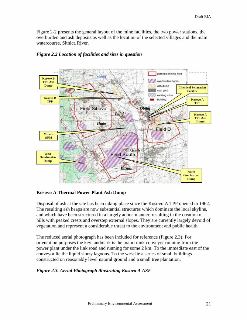
Figure 2-2 presents the general layout of the mine facilities, the two power stations, the overburden and ash deposits as well as the location of the selected villages and the main watercourse, Sitnica River. Figure 2.2 Location of facilities and sites in question
Kosovo A Thermal Power Plant Ash Dump Disposal of ash at the site has been taking place since the Kosovo A TPP opened in 1962. The resulting ash heaps are now substantial structures which dominate the local skyline, and which have been structured in a largely adhoc manner, resulting in the creation of hills with peaked crests and overstep external slopes. They are currently largely devoid of vegetation and represent a considerable threat to the environment and public health. The reduced aerial photograph has been included for reference (Figure 2.3). For orientation purposes the key landmark is the main trunk conveyor running from the power plant under the link road and running for some 2 km. To the immediate east of the conveyor lie the liquid slurry lagoons. To the west lie a series of small buildings constructed on reasonably level natural ground and a small tree plantation. Figure 2.3. Aerial Photograph illustrating Kosovo A ASF
Hade
KOSOVO A TPP
Obiliq
Lismir
Kuzmin
Sitnica
Palaj
Kosovo B TPP
Kosovo B TPP Ash
Dump
Mirash OPM
South Overburden
Dump
West Overburden
Dump
Kosovo A TPP
Kosovo A TPP Ash
Dump
Chemical Separation Facility

Draft EIA
Preliminary Environmental Assessment 22
Ultimately the tipped material is loose tipped from a tipping boom or spreader, resulting in random heaps of ash, left to consolidate and form an outer crust or skin at the natural angle of repose of the ash. Consequently, a profile of steep sided peaks and troughs resembling a ‘lunar landscape’ and capable of supporting only limited vegetation results. Discounting the slurry lagoons, and a considerable area to the west of the main ash tips, which is occupied by disturbed ground comprising former opencast mine overburden, the actual solid ash tips comprise two main areas to the east and west of the main ash trunk conveyor from the power plant. However, from the aerial photograph, it is evident that the western tip has an influence far greater than that occupied by current ash tipping, and this radiates out a further 400-500m in an almost circular formation out to the south and west of the main ash tip. Occupying in total an area in excess of 140 ha, the collective dry ash disposal heaps are in parts in excess of 40m thick, and are largely constructed on highly compressible soil formations. Currently little reliable information is available on the true extent and actual
Draft EIA
Preliminary Environmental Assessment 23
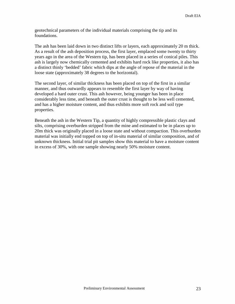
geotechnical parameters of the individual materials comprising the tip and its foundations. The ash has been laid down in two distinct lifts or layers, each approximately 20 m thick. As a result of the ash deposition process, the first layer, emplaced some twenty to thirty years ago in the area of the Western tip, has been placed in a series of conical piles. This ash is largely now chemically cemented and exhibits hard rock like properties, it also has a distinct thinly ‘bedded’ fabric which dips at the angle of repose of the material in the loose state (approximately 38 degrees to the horizontal). The second layer, of similar thickness has been placed on top of the first in a similar manner, and thus outwardly appears to resemble the first layer by way of having developed a hard outer crust. This ash however, being younger has been in place considerably less time, and beneath the outer crust is thought to be less well cemented, and has a higher moisture content, and thus exhibits more soft rock and soil type properties. Beneath the ash in the Western Tip, a quantity of highly compressible plastic clays and silts, comprising overburden stripped from the mine and estimated to be in places up to 20m thick was originally placed in a loose state and without compaction. This overburden material was initially end topped on top of in-situ material of similar composition, and of unknown thickness. Initial trial pit samples show this material to have a moisture content in excess of 30%, with one sample showing nearly 50% moisture content.

Draft EIA
Preliminary Environmental Assessment 24
Figure 2.4 View of Eastern Tip
Figure 2.5 View of Western Tip

Draft EIA
Preliminary Environmental Assessment 25
To the west and south of the western dry ash tip, a stockpile of overburden material is evident, predominantly topsoil and silty clays, taken from the Mirash mine. It appears that the material was placed prior to tip construction in this area, and therefore also currently underlies at least in part, the western tip. This is further evident from the substantial cracking noted throughout the western tip, which runs approximately N-S and indicative of movement of this tip in a generally western direction, as the foundation material is compressed and squeezed out under substantial loading. The western tip also shows considerable signs of instability and surface cracking, coupled with a phenomenon referred to as ‘toe heave’, further indicative of deep seated movement and possible failure of materials underlying the tip. Mirash Mine The general approach Lignite open pit / open cast mining comprises the following steps:
1. Stripping the overburden, which in the case of Mirash and Bardh OPM amounts to a thickness of several tens of meters.
2. Dumping of initial amounts of overburden on outside dumps, where it either
remains, or is later reused for backfill purposes at some later time. In the case of Bardh and Mirash OPM several outside overburden dumps have been created and no backfill operations been executed yet.
3. Mining of the coal seam(s), which might be divided by further layers of waste rock. In this phase overburden extracted from above the coal seams is re-deposited in the existing voids of the OPM.
4. Most Lignite mine operations affect the groundwater saturated zone, thus
pumping groundwater from the mines as well as installing galleries of pumping well around the pits are common practice. In Mirash OPM an additional problem is created by significant water ingressions from direct seepage of the River Sitnica at the eastern mine boundary.
a. Once the coal seams are exhausted recultivation starts, usually including partial backfill, regrading slopes and dumps, and letting groundwater rise again to natural levels. At most lignite OPMs lakes or ponds remain after final decommissioning. Acidification due to Pyrite in coal and overburden may pose a long term problem.
Mirash OPM and Bardh OPM today form an almost continuous mine operation, as the former pillar between the two pits has already been reduced in height by stripping the overburden. The total area covered by both OPM amounts to ~9.5 km². Today’s mining operations concentrate on the residual coal pillar dividing both OPM, situated South of Hade village. The mining of this residual coal will entail the enlargement of the (geotechnically defined) mine safety zone and necessitate the partial or complete relocation of Hade’s residents.

Draft EIA
Preliminary Environmental Assessment 26
The slopes of the Mines are defined by the geotechnical properties of the overburden as well as the coal seam and intercalated layers. The averages vary from 6 to 10° in the clay overburden materials, but are distinctly steeper (up to vertical) in the coal seams. Active mining operations in Bardh and Mirash OPM will be phased out during the coming few years. According to a mine plan prepared by DMT and Vattenfall (2005) Bardh OPM will cease to produce coal after March 2010. In the time period between 2006 and 2010, annual coal production will be reduced from around 2 Mt/annum in 2005 to less than 0.3 Mt/annum in 2010. Mirash OPM will continue to produce coal until 2010, however production rates will be stepped back from currently over 6.0 Mt/annum to around 2.5 Mt/annum. From 2010 coal production in Mirash will become increasingly uneconomic. The development of a new sub-field in the south-eastern mine sector is considered technically difficult and thus unfeasible. South and West Field Overburden Dumps There are a number of overburden dumps resulting from mining operation at both Mirash and Bardh. As part of this project, it is the largest of the overburden dumps, lying directly to the south of the mine and the one directly to its west that is of concern. The south dump is the largest of the outside overburden dumps created during former pit operation and covers around 50% of the prospective South Field for future mine development. It covers a total area of circa. 5.5 km2, a volume of about 90-110 Mm³ and has an average height of 20-30 m. The average slope angle is circa. 6°. Figure 2.6 South Field Overburden Dump
Overburden Dump
Draft EIA
Preliminary Environmental Assessment 27
The west overburden dump is of a similar height and sloping covering an area of circa 2.5km2.
In themselves, the overburden dumps are not a serious environmental problem. There are neither ongoing emissions, nor particular environmental risks associated within the dumps. Thus the attention warranted by the dumps relates more to upgrading of the land utilisation potential rather than remediation or mitigation. It offers a significantly large area for resettlement and land development, and even though some land use has already commenced unofficially, there is still a further potential of around 4-5 km2.
The dumps date back to the starting phase of the mine, have been in place for several years and are, where left to natural development, almost completely vegetated. Where the surface forms depressions, ponds have accumulated and wetland habitats have formed. The northern part shows a gentle relief, while in the middle and southern part smooth areas interchange with small hillocks, which are relics of the original tipping pattern. Chemical separation plant – source of phenols and other hazardous organic materials At the rear of Kosovo A Thermal Power Plant there is a chemical separation plant that prior to the war produced phenol and other organic materials, primarily as by-products from the gasification of coal. The gasification plant has not been in operation since the late 1980s. However, there is currently a large volume of hazardous materials stored in old, unprotected tanks on the site of this chemical separation facility. Among these hazardous materials totalling more than 13,000 m3 there are concentrated phenol, mixture of phenol and water; heavy tar; medium polluted oils; ammonium hydroxide; and benzene. Figure 2-7 presents evidence of extensive corrosion of some of the tanks storing phenols and other coal gasification by-products

Draft EIA
Preliminary Environmental Assessment 28
Figure 2.7 Project site for removal of phenols and organic materials
Explanation of numbers: 1 ASF A excavation site, 2: ash handover from Kosovo A TPP, 3: ASF B Excavation site, 4: Mirash OPM deposition area It is a matter of important that all of the above are removed from Kosovo and safely disposed of or recycled. The tanks are already presenting signs of cracks and they could create a significant international pollution incident due to their proximity to the Sitnicia River which ultimately flows into the Danube. If separate funds are available from other donors, the proposed Project intends to put out to international tender the removal, transport and disposal of all hazardous materials stored at the above chemical separation facility thus removing one of the most significant threats that the people and environment of the region faces today.

Draft EIA
Preliminary Environmental Assessment 29
3.0 BASELINE DATA
3.1. NATURAL SYSTEMS DESCRIPTION This section provides presents the natural systems within the project area. More comprehensive information will be available in the detailed EIA.
3.1.1. Landscape The current landscape in the Obiliq region is dominated by KEK activities particularly from a visual aspect. From the main road both from Pristina to Mitrovica and Pristina to Obiliq, Kosovo A and B TPPs, (both structures and plumes) dominate the horizon (refer to figure 3.1.1 below) The accompanying ash dumps for both power stations are also highly visible. The mining activities are less visible due to their relatively secluded location in comparison to the power stations and accompanying ash dumps. Figure 3.1.1
The Kosovo A ash dump, including the slurry lagoon area occupies a total surface area of circa 3.2 km2. The ash dump is located to the immediate south west of Kosovo A TPP. The area therefore to the north of the ash dump is heavily industrialised. Kosovo A TPP is substantial, incorporating not only a generating station, coal storage etc, but also a chemical separation facility. Beyond Kosovo A TPP lies the town of Obiliq. To the south east of the ash dump, circa 4 km, lies the town of Fushe Kosovo, which, as a result of the development of Pristina is slowly being incorporated into the city itself. The town is now, in essence, a suburb of Pristina. The land in the immediate vicinity of the ash dump is relatively low lying and level. It is primarily utilised for agriculture and consists mainly of small farm holdings. Immediately below and in the environs of the western tip of Kosovo A ash dump lies an overburden dump which radiates out in a westerly direction of 500-600m. The main mine complex lies circa 3km to the east of the ash dump. The land in between the ash dump and mine is utilised predominantly for agriculture, again primarily small farm holdings. The land is level and relatively low lying.
Draft EIA
Preliminary Environmental Assessment 30
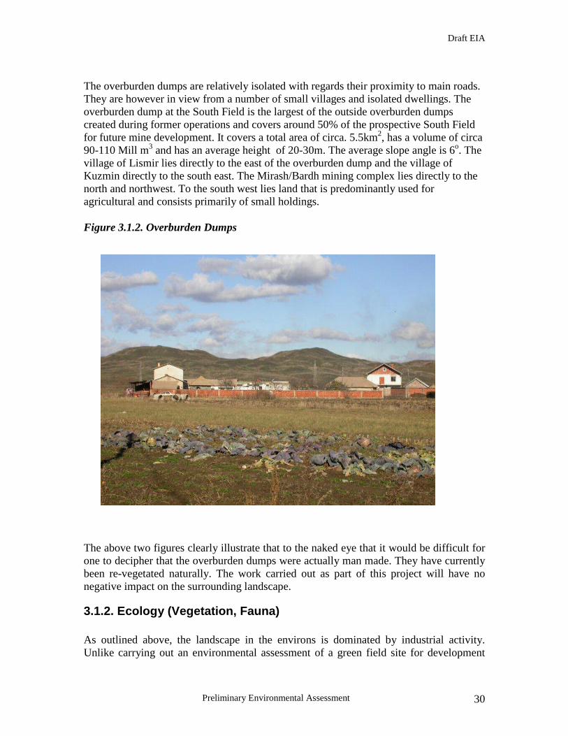
The overburden dumps are relatively isolated with regards their proximity to main roads. They are however in view from a number of small villages and isolated dwellings. The overburden dump at the South Field is the largest of the outside overburden dumps created during former operations and covers around 50% of the prospective South Field for future mine development. It covers a total area of circa. 5.5km2, has a volume of circa 90-110 Mill m3 and has an average height of 20-30m. The average slope angle is 6o. The village of Lismir lies directly to the east of the overburden dump and the village of Kuzmin directly to the south east. The Mirash/Bardh mining complex lies directly to the north and northwest. To the south west lies land that is predominantly used for agricultural and consists primarily of small holdings. Figure 3.1.2. Overburden Dumps
The above two figures clearly illustrate that to the naked eye that it would be difficult for one to decipher that the overburden dumps were actually man made. They have currently been re-vegetated naturally. The work carried out as part of this project will have no negative impact on the surrounding landscape.
3.1.2. Ecology (Vegetation, Fauna) As outlined above, the landscape in the environs is dominated by industrial activity. Unlike carrying out an environmental assessment of a green field site for development

Draft EIA
Preliminary Environmental Assessment 31
which may contain an abundance of diverse flora and fauna, the sites that make up this project have been stripped of most, and in some cases all, of the flora and fauna that may have existed before development. Furthermore, in their existing state in particular the ash dump, are having a negative impact on the surrounding flora and fauna. Expansion of vegetation communities is closely connected with different ecological conditions. It is evident from both previous research and observation that the flora and vegetation of the area has been significantly altered by the mining and power generation activities in the area. For example, white Armani (Pinus Peasie) has been replaced by herbs and indeed in some locations little vegetation has replaced it. This has resulted in much degradation of soil resulting in soil erosion in the area and altering of hydrological conditions. The area in general displays low forested or wooded plants whereas it is abundant in herbs and shrubs such as trefoil, dog rose, acacia etc. It must be noted that the natural habitats for this region have been significantly altered first by agriculture and then by industrial activity. With respect to fauna the area is populated primarily by a number of reptiles, birds and rodents. Domestic and agricultural animals make up the main mammal population in the area.
3.1.3. Climate conditions and Air quality Climate The Kosovo basin is characterised by a continental climate with dry and warm summers and indifferent winter temperatures depending on the influence of high pressure areas from Siberia and low-pressure areas from the Atlantic Ocean. Average annual temperature is about +10oC. For the years 1979 to 1991 the range of temperature is shown in the figure below with minimum temperatures in January and maximum in July. Lowest temperature ever measured is -25.2 oC.

Draft EIA
Preliminary Environmental Assessment 32
Figure 3.1.3a Average Annual Temperature 1979-1991
-10 °C
-5 °C
0 °C
5 °C
10 °C
15 °C
20 °C
25 °C
J F M A M J J A S O N Dm onth
tem
pera
ture
average 1965 - 1990 m aximum recordings 1979 - 1991 minim um recordings 1979 - 1991
data source: The Hydrom eteorological Institute of Kosovo
The wind is predominantly blowing from north and northeast with an average velocity near 3 m/s. The Rudarski Institute in the year 1995 gave an overview on wind velocities and directions shown in the following figure. The greatest wind velocity was recorded at 34.3 m/s blowing from the north. Figure 3.1.3b Overview of Wind Velocities 1995
The average annual precipitation amounts to about 600mm. Minimum precipitation is described by the 1990 data at 372 mm. Using monthly values maximum annual

Draft EIA
Preliminary Environmental Assessment 33
precipitation was recorded at 1010mm in the year 1995. The following figure shows the variation of average monthly precipitation. Statistically precipitation is rather evenly distributed with lower values from January to March and higher values throughout summer and autumn. Figure 3.1.3c Variation of average monthly precipitation
0 mm
10 mm
20 mm
30 mm
40 mm
50 mm
60 mm
70 mm
80 mm
I II III IV V VI VII VIII IX X XI XII
month
prec
ipita
tion
25 year average average 1948 - 1978 average 1979 - 2004
Air Quality The following tables illustrate air analysis taken in December 2005 and January 2006 from stationary air analysis units in the Obiliq area. These units are located at the Bardh Mine and in the grounds of the INKOS office which is equidistant between Kosovo A TPP and Kosovo A ASF. Both locations give a good indication of the ambient air quality at the sites in question as part of this preliminary environmental assessment. Analysis was carried out to measure SO2, soot and total deposited dust. The air analysis was carried out in line with British Standard 1747 (1979) in line with EU Council Directive 99/30/EC. All sampling for SO2 and soot was carried out over a 24 hour period for each sample. Table 3.1.3c Air Analysis Dec. 2005 & Jan. 2006 (ug/m3) Bardh Mine
December 2005 January 2005 Date SO2 Soot Date SO2 Soot ½ 10.47 10.91 ½ 6.99 1.39 2-3 3.66 4.73 2-3 4.89 2.8 3-4 2.61 5.85 3-4 10.49 1.39 4-5 3.14 1.04 4-5 12.59 1.39 5-6 4.19 5.61 5-6 4.89 1.39 6-7 2.09 2.85 6-7 4.87 1.37 7-8 5.23 3.14 7-8 1.39 2.79
Draft EIA
Preliminary Environmental Assessment 34
8-9 2.61 3.14 8-9 8.35 3.49 9-10 3.63 0.94 9-10 9.05 3.49 10-11 9.52 4.78 10-11 18.8 4.17 11-12 11.42 3.82 11-12 22.95 4.88 12-13 7.14 3.82 12-13 11.84 5.25 13-14 10 10.55 13-14 8.49 6.6 14-15 11.9 9.3 14-15 12.74 7.11 15-16 14.28 5.32 15-16 10.61 18.57 16-17 ‘4.96 2.49 16-17 9.9 24.92 17-18 7.44 0.98 17-18 11.9 38.64 18-19 6.44 1.99 18-19 3.35 4.91 19-20 3.96 11.66 19-20 4.95 3.55 20-21 9.92 20.73 20-21 16.29 18.78 21-22 2.48 21.59 21-22 18.33 39.76 22-23 5.95 24.25 22-23 8.14 2.03 23-24 3.13 16.33 23-24 10.86 3.41 24-25 3.91 15.3 24-25 14.25 3.41 25-26 2.35 44.29 25-26 10.18 4.76 26-27 3.13 6.28 26-27 14.93 33.2 27-28 4.7 3.93 27-28 3.55 54.17 28-29 2.35 3.93 28-29 19.92 72.74 29-30 3.91 1.55 29-30 29.88 81.22 30-31 4.19 2.09 30-31 17.79 50.86 31-1 13.29 4.9 31-1 5.69 20.51
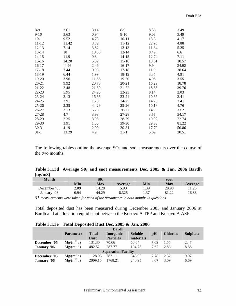
The following tables outline the average SO2 and soot measurements over the course of the two months.
Table 3.1.3d Average S02 and soot measurements Dec. 2005 & Jan. 2006 Bardh (ug/m3)
Month S02 soot Min Max Average Min Max Average
December ‘05 2.09 14.28 5.93 1.39 29.98 11.25 January ‘06 0.94 44.29 8.325 1.37 81.22 16.86
31 measurements were taken for each of the parameters in both months in questions
Total deposited dust has been measured during December 2005 and January 2006 at Bardh and at a location equidistant between the Kosovo A TPP and Kosovo A ASF. Table 3.1.3e Total Deposited Dust Dec. 2005 & Jan. 2006
Bardh Parameter Total
Dust Inorganic Particles
Soluble materials
pH Chlorine Sulphate
December ‘05 Mg/(m2 d) 131.30 70.66 60.64 7.09 1.55 2.47 January ‘06 Mg/(m2 d) 482.52 287.77 194.75 7.67 2.83 8.88
Separation Facility December ‘05 Mg/(m2 d) 1128.06 782.11 345.95 7.78 2.32 9.97 January ‘06 Mg/(m2 d) 2009.16 1768.21 240.95 8.07 3.09 6.69

Draft EIA
Preliminary Environmental Assessment 35
3.1.4. Noise The word noise is generally used to convey a negative response or attitude to the sound received by a listener. There are four common characteristics of sound, any or all of which determine listener response and the subsequent definition of the noise as ‘sound’. There characteristics are: intensity, loudness, annoyance and offensiveness. As part of an ongoing study regarding the development of a new mine at Sibvoc field, a number of noise measurements were taken on behalf of KEK as baseline measurements. These measurement where taken at Bardh Village, Hada Village and at a mechanical workshop at the existing mining facility at Bardh. These measurements, although not carried out specifically for this project, give a clear indication of noise levels at villages in the environs of the sites concerning this project and also give an indication of noise levels that emanate from mining activities which themselves give an indication of noise levels that may emanate from the engineering works to be carried out at the ash dump, Mirash OPM and overburden dumps. The following tables illustrate the measurements taken. All measurements were taken between 11am and 12 noon on the dates outlined below. Table 3.1.4a Noise measurements taken at Bardh and Hade Villages
Date Noise Level Bardh Village (dB)
Noise Level Hade Village (dB)
Temperature
28.12.2005 25 46 7.4oC4.01.2006 47 48 2.9oC6.01.2006 48 50 2.1oC11.01.2006 49 52 0.2oC12.01.2006 45 51 -3.9oC
Table 3.1.4b. Noise measurements taken at Bardh Mine (Mechanical Workshop)
Date Noise Level Bardh Mine Temperature 31.01.2006 55 2.1oC 1.02.2006 54 1oC 2.02.2006 56 -1oC
Details of typical construction plant noise levels and the percentage of the working day that the plant would typically be operating are shown in Table 3.1.4c below. Table 3.1.4c.Noise from Construction Plant (typical)
Item of Plant Sound Power Levels (dB re 10-
12 watts) Percentage On-time
Welding 70 70% Cranes 102 50%
Wheeled Loaders 104 65% Earth Moving 113 50%
Supply Vehicles 108 50% Truck Concrete Mixer 108 50%
Draft EIA
Preliminary Environmental Assessment 36
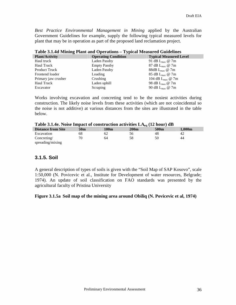
Best Practice Environmental Management in Mining applied by the Australian Government Guidelines for example, supply the following typical measured levels for plant that may be in operation as part of the proposed land reclamation project. Table 3.1.4d Mining Plant and Operations – Typical Measured Guidelines Plant/Activity Operating Condition Typical Measured Level Haul truck Laden Passby 91 dB Lmax @ 7m Haul Truck Empty Passby 87 dB Lmax @ 7m Product Truck Laden Passby 88dB Lmax @ 7m Frontend loader Loading 85 dB Lmax @ 7m Primary jaw crusher Crushing 104 dB Lmax @ 7m Haul Truck Laden uphill 98 dB Lmax @ 7m Excavator Scraping 90 dB Lmax @ 7m Works involving excavation and concreting tend to be the nosiest activities during construction. The likely noise levels from these activities (which are not coincidental so the noise is not additive) at various distances from the sites are illustrated in the table below. Table 3.1.4e. Noise Impact of construction activities LAeq (12 hour) dB Distance from Site 50m 100m 200m 500m 1,000m Excavation 68 62 56 48 42 Concreting/ spreading/mixing
70 64 58 50 44
3.1.5. Soil A general description of types of soils is given with the “Soil Map of SAP Kosovo”, scale 1:50,000 (N. Povicevic et al., Institute for Development of water resources, Belgrade; 1974). An update of soil classification on FAO standards was presented by the agricultural faculty of Pristina University Figure 3.1.5a Soil map of the mining area around Obiliq (N. Povicevic et al, 1974)

Draft EIA
Preliminary Environmental Assessment 37
3.1.6. Hydrogeological situation The hydrogeological situation of the area is defined by three main hydrogeological units, described from bottom upwards: The basic hydrogeological unit is made up by the “green clay” consisting of clay and silt with general thickness of more than 100 m. Hydrogeologically it can be classified as an aquiclude, i. e. a non water bearing horizon. The second hydrogeological unit is the overlying Lignite coal with a thickness of up to 70 m. The coal is generally described to have poor permeability but, due to fissures and cracks within the coal, can be classified as a discontinuity controlled aquifer (as opposed to a porous aquifer). This implies that groundwater can percolate in confined zones and that permeability / conductivity will be heterogeneous in different (x/y/z) directions.

Draft EIA
Preliminary Environmental Assessment 38
Before the main drainage sump in Mirash OPM was constructed, the lignite layer was in fact observed to be water bearing by means of observation wells. However, during this assignment no exact data on the groundwater head or any observed water ingressions from the Lignite layer were available. The third and uppermost unit, following in the sequence as overburden above the coal layer, is made up mainly by silt and clay (termed “grey clay”) with occasional occurrence layers consisting of sand, gravel or detritus of fossil gastropod shells. Generally the clay material can be classified as an aquiclude. However, faults, fissures and cracks can reportedly reach depths of 10 to 15 m from the surface, forming potential pathways for groundwater migration. In the Mirash OPM groundwater was observed to appear either from faults and other discontinuities, especially when connected to coarser, permeable, water bearing intercalations (such as the above mentioned sand, gastropod shell or gravel layers). The resulting hydraulic conductivity thus varies widely according to material composition (grain size) and frequency / persistence / spacing / orientation of the discontinuities. Locally enhanced pathways can be created by erosion of the overburden (by river channels) to a thickness of a few meters, or the collapse of abandoned underground works, exposing the Lignite layer to accelerated infiltration by precipitation or seepage from river Sitnica. Groundwater utilisation is restricted to private wells dug to a depth of 10 to 15m below ground level in the overburden clay. Production quantities are shown by the Rudaski Institute (1985) with Q=3 l/min to Q=11 l/min with a maximum of Q = 54 l/min, which correspond to hydraulic conductivities in a range of Kf=10-9 m/s to Kf=10-6 m/s. Inhabitants in the area describe the wells as unproductive but sufficient for private use. The water collected in these wells is expected to source from precipitation and seepage, rather than the water table of a regionally developed aquifer. A fourth hydrogeological unit might be defined as the quaternary fluvial sedimentary deposits along the river Sitnica. Regarding their composition some areas, e. g. where the natural valley narrows, are expected to be dominated by sand and gravel as main constituents, with a resulting hydraulic conductivity of up to Kf=10-4 m/s. Other areas with lower flow velocities will be made up mainly of silt and lay fraction from the grey clay. Also towards the depth silt and clay contents increase and permeability decreases, grading into the typical “grey clay” lithology. The latter prevents a direct contact between surface waters and coal seam. Infiltration rates from Sitnica river into the groundwater are expected to be low due to above presented lithological situation. The groundwater table in he grey clay is said to lie some 10-15 m below ground level and no hydraulic connection to smaller surface runoffs exist (DMT/Vatenfall: Main Mining Plan for New Sibovc Field, Part III Environmental Impact Study, June 24th, 2005).

Draft EIA
Preliminary Environmental Assessment 39
It should be noted, that the original groundwater flow regime (about which very little is known) is today disturbed and changed by the Bardh / Mirash OPM operation. The mine acts as a large groundwater sink / sump, thus regionally flow directions will have adjusted towards the mine. The quantities of groundwater ingressions into the mines are not known. Waters pumped from the mines consist of precipitation as well as seepage from groundwater. In Bardh the pumped monthly quantities are well under the expected amount of 80,000 m³/month. In Mirash the pumped amounts (387,000 m³/m) exceed the amount expected by precipitation only (~150,000 m³/m) by factor 2.5. This difference is attributed to groundwater ingressions, most of which however appear to stem from a confined area where the mine boundary has cut the Sitnica river sediments. The considerable discharge is probably due to their higher permeability and the proximity of Sitnica, which creates a direct, “short circuit type” hydraulic connection. No data regarding groundwater quality from the Obiliq mining area were available for this study. The concern is the possible pollution of groundwater from phenols and other organic compounds that could have been dumped improperly on the ASF site during the past mine operation. In this regard, recent drillings performed by KEK in the middle of Kosovo A west ash dump during spring 2006 allowed analyses of about 36 samples of soil/clay and ash taken over a depth of 82.5 m (from the top of the ash dump). The results of these samples showed elevated concentration of cadmium (above the maximum allowed standard value for ash) while phenol and PAH were within the acceptable limits. This results as well as the given structure of the soil (ash layer followed by overburden clay and coal layers at low permeability) allow one to conclude that contamination of groundwater from phenols and PAHs is slightly possible. Furthermore, the alkaline content of the ash/clay samples prevents dissemination of the organic materials in groundwater if ever reaching its level. However, further detailed sampling is necessary to confirm this scenario.
3.1.7. Surface waters The Kosovo Basin forms a smoothly shaped plain that is bordered by hills and mountains. The Basin includes a well developed hydrological network with the main collector being the river Sitnica. This river crosses the basin from South to North and drains about 80% of the accumulating surface water flowing in a northern direction. Major tributary rivers in the vicinity of the site are the River Drenica in the west and the River Lab in the East. The Sitnica run-off varies between a minimum of 0.5 – 1.5 m3/s and a maximum of 50 – 120 m3/s with an average of 5 – 10 m3/s. In flooding periods, the course of the river reaches a width of up to 1000m in the flooding areas. On 3rd May 1958 a maximum run-off for the Sitnica river near to the mines was measured at 90.3 m3/s. Surface water quality data is available from INKOS Institutes monthly measurements for the main catchments, Drenica and Sitnica. The measurements compiled for the years 2001 to 2003 presented below can be taken as baseline data to assess the impact of any future development in the Area.

Draft EIA
Preliminary Environmental Assessment 40
Figure 3.1.7a Surface Water Quality 2001 - 2003
The parameters shown in the figure above are found adequate to represent the up to date quality of river water. With reference to heavy metals or other trace elements, no statements are possible to date because analytical data are not available on these parameters. The detailed EIA that will be developed during the project preparation will develop a complete set of results including heavy metals analysis. Figure 3.1.7b Surface water sample Locations

Draft EIA
Preliminary Environmental Assessment 41
The figure above illustrates the locations of where water samples are taken in the environs of the sites that make up this project. Samples used for the purpose of this pre-EIA study include numbers 1-7. The following tables illustrate sample results taken from seven positions in the environs of the mine. Table 3.1.7c Chemical and physical analysis of surface water bodies November 2005 Parameter M1 M2 M3 M4 M5 M6 M7 EU
Limits Temperature oC 6.0 7.2 9.5 6.7 11.2 10.6 8.4 Electric conductivity µS
560 500 1300 555 1550 2750 700 10001
pH 8.3 8.3 8.2 8.4 7.9 7.8 7.9 6-92
Nitrates mg/l NO3 5.42 5.42 4.52 2.71 13.56 72.32 4.52 251
Dissolved Oxygen % saturation O2
92.70 95.78 96.6 94.56 95.91 123.83 88.16 80-1202
Chlorides mg/l CL 36 31 152 28 83 123.83 40 2001
Suspended Solids mg/l SS
105 70 340 85 250 285 125 251
Sulfates mg/l SO4 69.34 42.38 168.92 83.55 250 1270.71 108.22 1501
Phenols mg/l C6H5OH
0.0035 - 0.010 - 0.013 - 0.005 <0.0052
Source: INKOS 1Council Directive (75/440/EEC) concerning the quality of surface water intended for the abstraction of drinking water 2Council Directive (76/160/EEC) concerning the quality of bathing waters Table 3.1.7d Chemical and physical analysis of surface water bodies December 2005 Parameter M1 M2 M3 M4 M5 M6 M7 EU
Limits Temperature oC 11.76 7.2 11.33 7.0 10.8 10.67 7.1 Electric conductivity µS
410 425 985 450 16550 3350 555 10001
pH 7.5 7.7 8.2 7.8 7.9 7.5 7.3 6-92
Nitrates mg/l NO3 3.61 2.26 5.87 2.26 14.46 54.24 3.61 251
Dissolved Oxygen % saturation O2
77.63 80.61 100.61 81.46 72.31 96.72 82.23 80-1202
Chlorides mg/l CL 37 33 134 29 85 101 48 2001
Suspended Solids mg/l SS
125 95 225 100 200 675 140 251
Sulfates mg/l SO4 68.51 50.61 233.32 51.44 796.25 1450.33 111.31 1501
Phenols mg/l C6H5OH
0.005 - 0.0035 - 0.0075 - 0.006 <0.0052
1Council Directive (75/440/EEC) concerning the quality of surface water intended for the abstraction of drinking water 2Council Directive (76/160/EEC) concerning the quality of bathing waters Source: INKOS

Draft EIA
Preliminary Environmental Assessment 42
3.2. Environmental Pollution Site of storage of Hazardous Chemicals The potential threat that the continuous storage of hazardous chemical materials at the chemical separation facility poses is significant. The containment facilities (tanks) for the hazardous materials are far from adequate (e.g., already one tank has shown clear signs of splitting). The current potential hazardous materials stored on the site include the following chemicals and their respective volumes: TAR (1,000m3); Heavy Tar (500m3); medium oils (1,000m3); Ammonium Hydroxide (1,000m3); benzene (500m3); polluted oil (250m3); phenol mixed with water (13,000 m3); and concentrated phenol (750 m3). It is believed that some of the oils have been mixed which makes the removal processes and particularly the disposal process more complex.
Other sources of environmental degradation At present, although the Mirash OPM can not be viewed from any road or building, it is an eye soar and it is evident that the mining activity has had a detrimental impact on the visual landscape of the area. As is clearly evident throughout this report the Kosovo A ash dump is devoid of any habitation apart from a limited area that has been recolonised by grasses. The soil overburden to the immediate west of the Western Ash tip has been colonised by natural reed beds, however these reed beds are out of context with the surrounding environment and what would not have developed there if dumping and overburden had not taken place. The present utilisation of the area for ash dumping has had and still has a significant negative impact on the ecology of the region. Vast acres of land as well as the habitats that would have thrived prior to ash disposal have been completely destroyed. Currently a significant amount of dust is being generated at Kosovo A ASF due to disposal, lack of adequate mitigation measures and adhoc tipping regime. Currently the conveyor belts used for the transport of ash are in a state of disrepair and allow hige amount of dust to be dispersed during mine operations. Furthermore there is a significant lack of aftercare regarding contouring and regarding of the disposal area. Furthermore, in analyzing the figures in Tables 3.1.3 mentioned above, one can clearly see the excessive levels of total dust at the separation facility in the vicinity of Kosovo A ASF in comparison to Bardh. The WHO limits for total dust is 300mg/(m2 d) in comparison to that experienced at separation facility during January 2006 with figures in excess of 2,000 mg(m2 d). This clearly illustrates the negative environmental impact being experienced as a result of Kosovo A power station and the ash dump combined. These excessive levels clearly illustrate the necessity for the remediation of Kosovo A Ash Dump. Evaluation of Baseline Data and Recommendations for Additional Work At the request of the World Bank KEK have drilled a single borehole with accompanying sampling and analysis in the Western Tip of Kosovo A Ash Dump as part of the preliminary environmental assessment. ). The results of these samples showed elevated concentration of cadmium (above the maximum allowed standard value for ash) while phenol and PAH were within the acceptable limits. This results as well as the given

Draft EIA
Preliminary Environmental Assessment 43
structure of the soil (ash layer followed by overburden clay and coal layers at low permeability) allow one to conclude that contamination of groundwater from phenols and PAHs is slightly possible. Furthermore, the alkaline content of the ash/clay samples prevents dissemination of the organic materials in groundwater if ever reaching its level. However, further detailed sampling is necessary to confirm this scenario. In the case of the Kosovo A Ash Dump, the Mirash OPM environment and the overburden dumps the following main criteria have to be included into a thorough investigation campaign that will represent the base of a detailed EIA:
• exact geometrical layout, preferably as a digital surface model;
• physical (geotechnical, geo-mechanical) properties of relevant materials
• geotechnical stability of slopes, dumps and engineered structures (e.g. dams)
• chemical properties of ash and other potentially hazardous materials
• geological, hydrogeological and hydrological environment
The aim of the investigation campaign is the understanding of the geological, hydrogeological and geotechnical situation, the sources, pathways and potential receptors of harmful chemicals and other environmental hazards. The engineering properties of the dumps or other materials and structures, which have been emplaced, constructed, altered or influenced by technological activities also should be known in detail. The data collected should provide the engineering database and design parameters for a technical remediation design. KEK and its former in-house investigation and laboratory branch INKOS have conducted some recent surveys and investigation campaigns, which should be reviewed and as much as possible incorporated in the new data gathering phase.
Topographical Surveys
Where data is not already available at KEK, the following survey works are recommended to be carried out: • Topographical surveys of Kosovo A ASF and the adjacent overburden dump,
including surroundings (original ground) on all sides, estimated area about 3.5 km², required scale of survey 1:1,000, spacing of isohypses not more than 2 m.
• Topographical survey of the east part of Mirash OPM deposition area and adjacent pit slopes, including watercourse of Sitnica river and potential conveyor belt
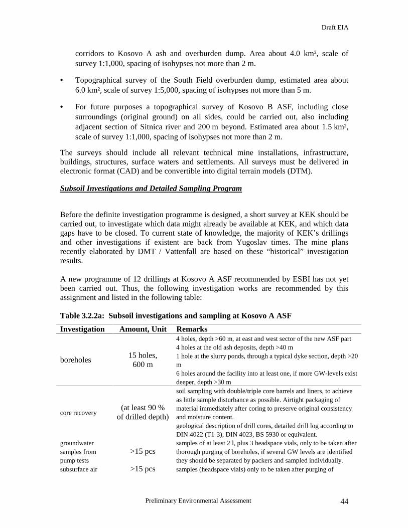
Draft EIA
Preliminary Environmental Assessment 44
corridors to Kosovo A ash and overburden dump. Area about 4.0 km², scale of survey 1:1,000, spacing of isohypses not more than 2 m.
• Topographical survey of the South Field overburden dump, estimated area about 6.0 km², scale of survey 1:5,000, spacing of isohypses not more than 5 m.
• For future purposes a topographical survey of Kosovo B ASF, including close surroundings (original ground) on all sides, could be carried out, also including adjacent section of Sitnica river and 200 m beyond. Estimated area about 1.5 km², scale of survey 1:1,000, spacing of isohypses not more than 2 m.
The surveys should include all relevant technical mine installations, infrastructure, buildings, structures, surface waters and settlements. All surveys must be delivered in electronic format (CAD) and be convertible into digital terrain models (DTM).
Subsoil Investigations and Detailed Sampling Program
Before the definite investigation programme is designed, a short survey at KEK should be carried out, to investigate which data might already be available at KEK, and which data gaps have to be closed. To current state of knowledge, the majority of KEK’s drillings and other investigations if existent are back from Yugoslav times. The mine plans recently elaborated by DMT / Vattenfall are based on these “historical” investigation results. A new programme of 12 drillings at Kosovo A ASF recommended by ESBI has not yet been carried out. Thus, the following investigation works are recommended by this assignment and listed in the following table:
Table 3.2.2a: Subsoil investigations and sampling at Kosovo A ASF
Investigation Amount, Unit Remarks
boreholes 15 holes,
600 m
4 holes, depth >60 m, at east and west sector of the new ASF part 4 holes at the old ash deposits, depth >40 m 1 hole at the slurry ponds, through a typical dyke section, depth >20 m6 holes around the facility into at least one, if more GW-levels exist deeper, depth >30 m
core recovery (at least 90 %
of drilled depth)
soil sampling with double/triple core barrels and liners, to achieve as little sample disturbance as possible. Airtight packaging of material immediately after coring to preserve original consistency and moisture content. geological description of drill cores, detailed drill log according to DIN 4022 (T1-3), DIN 4023, BS 5930 or equivalent.
groundwater samples from pump tests
>15 pcs samples of at least 2 l, plus 3 headspace vials, only to be taken after thorough purging of boreholes, if several GW levels are identified they should be separated by packers and sampled individually.
subsurface air >15 pcs samples (headspace vials) only to be taken after purging of

Draft EIA
Preliminary Environmental Assessment 45
sampling borehole air, at least 1.5 times the calculated air volume; purpose: detection of volatile organic contaminants not directly touched by boreholes, i. e. as an indication for further, more targeted investigations.
soil samples from drillcores
>250 pcs one sample per every significant change of lithology, sensory hints on contaminations or other conspicuous observations; else one sample per 3 m in uniform soil strata.
undisturbed samples from dump surfaces with cylinder method
~20 pcs
sample size should have standard diameter of 114 mm (DIN 4021), quality of sample should allow to test / measure grain distribution, water content, natural density (γ), deformation modulus (E) and
shear strength (τ).
seismic lines 2 km length detection of suspected underground works, if they cannot be conclusively located from old mine plans, aerial photographs an other evidence available at KEK
vane tests (VT), standard penetration tests (SPT), cone penetration tests (CPT)
e.g. 30 VT 30 SPT 20 CPT
these are indirect field investigation methods to establish shear strength (vane test) or settlement conditions (SPT, CPT) of soil type materials; if calibrated with boreholes they can provide supplementary information to narrow gaps in a geological / hydrogeological model, while saving on more expensive drilling
The investigation campaign at the South Field overburden dump will establish the necessary geotechnical, geological and hydrogeological parameters to characterize materials and overall stability at the site. Some spot sampling will be done to search for any indications of environmental issues to be considered in the further project course. In Mirash OPM the foundations for the future final ash deposit will be investigated and characterized closely enough to design the necessary preparation measures for ash reception. At both sites the drilling locations will be spaced evenly and widely to cover the whole area under investigation. Table 3.2.2b: Subsoil investigations and sampling at South Field Overburden Dump
and Mirash OPM
Investigation Amount, Unit Remarks
boreholes 10 holes, 300 m
5 holes, depth >40 m, South Field overburden dump 5 holes at Mirash OPM, depth >20 m
core recovery (at least 90 %
of drilled depth)
soil sampling with double/triple core barrels and liners, to achieve as little sample disturbance as possible. Airtight packaging of material immediately after coring to preserve original consistency and moisture content. geological description of drill cores, detailed drill log according to DIN 4022 (T1-3), DIN 4023, BS 5930 or equivalent.
groundwater samples from pump tests
>5 pcs samples of at least 2 litres, plus 3 headspace vials, only to be taken after thorough purging of boreholes, if several GW levels are identified they should be separated by packers and sampled

Draft EIA
Preliminary Environmental Assessment 46
individually.
subsurface air sampling
>5 pcs
samples (headspace vials) only to be taken after purging of borehole air, at least 1.5 times the calculated air volume; purpose: detection of volatile organic contaminants not directly touched by boreholes, i. e. as an indication for further, more targeted investigations.
soil samples from drillcores
>100 pcs one sample per every significant change of lithology, sensory hints on contaminations or other conspicuous observations; else one sample per 3 m in uniform soil strata.
undisturbed samples from ground surfaces with cylinder method
~5 pcs
sample size should have standard diameter of 114 mm (DIN 4021), quality of sample should allow to test / measure grain distribution, water content, natural density (γ), deformation modulus (E) and
shear strength (τ).
standard penetration tests (SPT), cone penetration tests (CPT)
e. g. 20 SPT 10 CPT
these are indirect field investigation methods to establish settlement conditions (SPT, CPT) of soil type materials; if calibrated with boreholes they can provide supplementary information to narrow gaps in a geological / hydrogeological model, while saving on more expensive drilling
Geotechnical Field Tests and Laboratory Analyses
The samples for geotechnical testing will be derived from drillcores and the undisturbed surface samples. The following parameters are suggested to be investigated. The below proposed number of samples refer to ASF Kosovo A:
• 100 samples:densities (natural density; dry density; specific gravity of the solids)
• 100 samples: water content, saturation index and porosity or void ratio ()
• 100 samples: grain size distribution
• 50 samples: consistency limits of cohesive tailings (liquid limit; plasticity limit) incl. plasticity index
• 30 samples: degree of consolidation, particularly of cohesive tailings layers (void ratio, effective stress relationship), Proctor test, Oedometer test
• 30 samples: effective static shear strength parameters (friction angle; cohesion)
• 20 samples: hydraulic behavior of ash: water absorption capacity, cementation properties, optimum water content for maximum strength (measures with point load tests or uniaxial load test)
For The South Field overburden dump and Mirash OPM the proposed numbers of tests are outlined below:

Draft EIA
Preliminary Environmental Assessment 47
• 25 samples:densities (natural density; dry density; specific gravity of the solids)
• 25 samples: water content, saturation index and porosity or void ratio ()
• 25 samples: grain size distribution
• 20 samples: consistency limits of cohesive tailings (liquid limit; plasticity limit) incl. plasticity index
• 20 samples: degree of consolidation, particularly of cohesive tailings layers (void ratio, effective stress relationship), Proctor test, Oedometer test
• 20 samples: effective static shear strength parameters (friction angle; cohesion)
The proposed number of tests should allow a fair statistical characterization of the encountered materials and give a useful base as design parameters for the reshaping, removal and / or re-deposition planning.
Environmental and Geochemical Laboratory Tests
The materials recommended to be analysed include: ash; overburden; ASF foundation materials; water (seepage from ASF, mine waters, groundwater under ASF); gaseous phase in soil fabric (subsurface air). The following parameters recommended to be investigated at Kosovo A ASF, where strong environmental concerns give rise to an intensified chemical testing programme.
• Groundwater: general element spectrum, heavy metals, organic chemicals (aliphatic and aromatic hydrocarbons, BTEX (benzene, toluene, ethylbenzene, xylene), polycyclic aromatic hydrocarbons (PAH), phenol index and individual phenol compounds, volatile halogenated hydrocarbons (VHHC), additionally T, conductivity, redox potential, TSS, BOD, TOD, oxygen content Cl-, SO4
2-, NO3-,
CO32-. At Mirash OPM testing for organic chemicals should also be performed on
a screening level to detect a potential influence of the suspected phenol contamination.
• Subsurface air: BTEX, aliphatic hydrocarbons, VHHC, phenol-index
• Ash, overburden, ASF foundations: pH, sulphur, TOC, general element
spectrum, heavy metals, organic chemicals (aliphatic and aromatic hydrocarbons, BTEX (benzene, toluene, ethylbenzene, xylene), polycyclic aromatic hydrocarbons (PAH), phenol index and individual phenol compounds, volatile halogenated hydrocarbons (VHHC)
Draft EIA
Preliminary Environmental Assessment 48
It is recommended to carry out detailed analytical chemical tests in at least two steps as described below:
1. Contaminations of mobile media such as groundwater and subsurface air should be primarily carried out to gain information if in principle significant contaminations are to be expected in or under the ASF. They should be supplemented by a relatively widely spaced grid of soil samples, to constitute a first screening of the ASF.
2. If the results from air / GW and / or spot soil sampling indicate any presence of contaminations, further, more detailed analyses should be carried out. Depending on the indications from the screening analyses these would include a higher number of soil samples around previously detected hot spots, additional GW samples, preferably taken during pump tests performed for the specific aquifers identified as contaminated or at least suspect before.
Geotechnical Instrumentation
Geotechnical instrumentation is highly recommendable to investigate and understand identified stability issues at the Kosovo A ASF (notably the W sector and the old overburden dump) and observe / verify suspected stability problems in the S sector of the South field overburden dump. The suggested instrumentation and methodology is listed below:
• Old overburden dump adjacent to ASF: 4 inclinometers, 3 forming an approximate E-W line from the base of the ASF to the tip of the unstable material (near the abandoned settlement), 1 inclinometer W of the current front to detect the onset of new sliding planes. Optical targets (for high precision 3D deformation monitoring) and simple peg-lines (“spies”) on the surface of the dump to observe surface deformation.
• Mirash OPM, E slope: 3 inclinometers and 3 extensometers at the top of the slope
to monitor any ongoing movements and assess the impact of ash deposition. Optical targets for high precision 3D deformation monitoring at exposed topographical points in the slope as well as on the top of the slope to complement subsoil information.
• South Field overburden dump: 2-3 inclinometers at the areas in the S-sector,
reported to exhibit some geotechnical instabilities. Supplementary information from simple peg-lines (“spies”) to observe surface deformation.

Draft EIA
Preliminary Environmental Assessment 49
Inclinometers are the best known method to directly observe differential movements at a sliding plane or plane of separation in a mass movement or slope instability. For their functionality they have, however, to be installed such that they pass through a plane separating two blocks of material with differential movement vectors. In the case of the ASF and overburden dumps a sufficiently deep installation into the original ground under the anthopogenically altered materials, or the suspected unstable mass, has to be granted. If this preconditions are met, the location of the sliding plane as well as the activity can be monitored with high precision. Most inclinometers require manual readings (automatic ones are several times more expensive), thus a geotechnical measuring unit would have to be created and staffed at KEK. This unit should be combined with other monitoring activities, such as 3D deformation measurements, groundwater readings and periodic GW samplings.
Hydrogeological Investigations
The aim of hydrogeological investigations is to monitor groundwater levels, assess the contamination situation, the contaminant transport capacity and distinguish specific aquifers and their potential connection/interaction. At the ASF all boreholes, where significant amounts of groundwater are encountered, should be equipped as standpipes / groundwater wells, built to different depth levels of ash/overburden dump (depending on the number and levels of aquifers in ash, overburden and original ground. At Mirash OPM and the South Field overburden dump at least 2 of the proposed boreholes should be equipped as permanent GW observation wells. The wells must be immediately purged after construction, during purging constant observation of the pump rates and GW levels is required. The wells should subsequently be monitored continuously, either by manual readings or with piezometers and automatic loggers (which could be combined with a transmission system for remote readings). At boreholes, where contaminations are detected, pump tests should be performed, during which pump rates and GW levels are constantly recorded and samples taken for chemical analysis. This will yield valuable information on the general GW regime, flow direction and speed, and contaminant transport mechanisms via the groundwater path. If necessary, tracer tests could be executed as a supplementary investigation method to investigate specific contaminant transport scenarios.

Draft EIA
Preliminary Environmental Assessment 50
3.3. Socio-economic data (Human Beings) A report entitled ‘Kosovo and its population’, prepared by the Statistical Office of Kosovo (SOK), estimates the population of Obiliq to be in the region of 31,000. The area of project implementation is in what would be classified as an industrial zone dominated by the two power stations. The main populated areas in the region are Obiliq, Palaj, Hade, Lismir, Kuzmin and Fushe Kosovo. There has been no detailed population census carried out since the 1980s. It is therefore not possible to give accurate details of the demographic make up of the area, however, it is estimated that the total population of the area is in the region of 45,000 people. Current economic activity in the Region is dominated by KEK activities, primarily those involving coal production and power generation. 3,703 are employed in all KEK mining activities and a further 1,597 at both Kosovo A and Kosovo B TPPs. No exact statistics are available on the general economic activities of the area. However unemployment in the region is high and based on information available from the Statistical Office of Kosovo is approximately 39%. However unofficial figures put the rate of unemployment in the Obiliq at circa 70%. Much of the area in and around the generation and mining activities/facilities is used for agriculture with a mixture of arable and livestock development apparent. The agricultural activity consists predominantly of small properties and carried out, due to lack of affordability of modern agricultural machinery and facilities, in a simple manner.

Draft EIA
Preliminary Environmental Assessment 51
4.0 ENVIRONMENTAL IMPACTS
The proposed project’s primary objective is environmental restoration, specifically the cleanup of ash-contaminated area surrounding the mining activities in the Obliq/ Obilic city and land reclamation of the cleaned sites, as a necessary step in assuring safe environment and agriculture for humans and a clean environment for natural habitats and ecosystems. The main environmental impacts of the proposed project actions are affiliated with the cleanup of the former gasification plant site, that is consisting in the packaging and transport to incineration of about 13,000 m3 of phenol, benzene and other coal gasification affiliated organic materials. The need for very careful planning and specialized precautions and mitigating measures to prevent, minimize or respond to inadvertent releases of phenols and other coal gasification by-product compounds and associated pollutants in soil and groundwater requires conducting a detailed Environmental Impact Assessment (EIA) and preparing an Environmental Management Plan (EMP). Currently, the project is not financing the removal of the phenols at the former gasification site, but once financing has been found a separate EIA and EMP will be prepared according to category A criteria because it could cause significant environmental impacts affecting an area broader than the sites subject to remediation.
Background on Phenols and other Hazardous Organic Materials resulted from Coal Gasification Process The phenols stored in their present state pose a significant threat to groundwater, surface water bodies (rivers/streams), soils, plant growth and nutrient supply. What is Phenol?
• Phenol is primarily a man-made chemical • It was first isolated in 1834 and was called carbolic acid • Coal tar was the only source of Phenol until WWI • The first synthetic phenol was produced by sulfonation of benzene and hydrolysis
of the sulfonate
Uses of Phenol • As an intermediate in the production of phenolic resins used in the plywood
adhesive, construction, automotive and appliance industries • As an intermediate in the production of caprolactum which is used to make nylon
and other synthetic fibres and biphenol A which is used to make epoxy and other resins
• As a slimicide which is a chemical toxic to bacteria and fungi • As a disinfectant
Phenol Hazard Summary • Phenol is a mutagen – a mutagen is a substance or agent that causes an increase in
the rate of change in genes (subsections of the DNA of the body’s cells). These
Draft EIA
Preliminary Environmental Assessment 52
mutations (changes) can be passed along as the cell reproduces leading to defectives cells, deformities and cancer
• Exposure can cause a build up of fluid in the lungs (pulmonary adema – a medical emergency)
• High or repeated exposure may damage the liver, kidneys and nervous system The potential impact on the environment of phenols and hazardous materials derived from coal gasification process are listed below: Threat to Groundwater
• Non aqueous phase liquids such as coal tars, when spilled on land travel through the soil into the groundwater where they sink to the bottom of the aquifer to remain as a source of pollution for many many years
• A slowly leaking storage tank in an aquifer has the ability to severely contaminate massive volumes of groundwater if the leak goes undetected
• Many of these contaminants are potentially serious polluters of groundwater at trace levels i.e. barely detectable
Effects on Soil
• Contaminants at the site may decrease the solubility of the soil; • May increase the soils susceptibility to erosion by wind and water; • Contamination may cause aggregate breakdown and dispersion of fine particles; • Plant available water reserves may be reduced; • Affects the pH of the soil
Effects on plant growth and nutrient supply
• May directly kill plants upon contact; • May retard growth; • May inhibit seed germination and create nutrient limitation.
Environmental Assessment of Selected Alternative Description of Selected Alternative Based on two reports prepared on behalf of the World Bank during November and December 2005, the following is the scheme that has been proposed on behalf of the World Bank as part of the proposed Project.
• Preparation of the Mirash Open Pit Mine for Ash Management • Relocation of Kosovo A Ash Dumps into Mirash Open Pit Mine • Reclamation of Overburden Dump Areas
As part of the FS developed for the project, it was also proposed the project alternative involving removal of phenol and other hazardous materials (coal gasification organic by-products) currently stored on the site of the former gasification plant. This alternative action will be envisaged by the final project if available funds (outside those proposed for the above listed actions) will be made from other donors.

Draft EIA
Preliminary Environmental Assessment 53
Preparation of Mirash OPM for receipt of Ash Basic Drainage A plain and stable basic layer is necessary for installing the clay sealing layer. The available swampy ground level does not meet these requirements. The eastern section of the Eastern Part of Mirash OPM is currently being developed for ‘wet’ ash disposal from Kosovo B TPP. This area of the mine forms a boundary with the Sitnica River which has meant a number of drainage mitigation measures have been necessary. The drainage measures being carried out as part of this project concerning the disposal of ‘wet’ ash from Kosovo B TPP will have many positive impacts on the preparation of Mirash OPM for this project in particular with regards to drainage. Nevertheless some drainage measures will be necessary. After completion of the earthworks for routes and water collection areas, the full pipes shall be laid in an at least 0.5 m deep ditch and connected workmanlike to the underground laid pipelines. Both laying of the full pipes in the ditches and connection to the water collection plants and underground pipelines shall be performed in a way that prevents water from flowing out of the pipe connections. Swamp and water areas which will not dry out shall be covered by overburden according to the correct specification. If the covering is not sufficient drainage shall be performed by means of sewage pumps if necessary. The drained water shall be fed to a designated dewatering area for the Mirash OPM.
Producing the dump space and slope stabilisation After the water courses have been drained and diverted into pipes the dump ground shall be planed. The slopes shall be prepared as specified in the design and it shall be considered that the slope inclination of the single slopes must be at least 1:4 because mobile earthworks equipment will move on it in the following work steps. The material to be placed on the slopes should be clay. For protecting the laid drainage pipes there shall be placed a super-elevation. The prepared ground surface must be apparently plain and solid so that a mineral cover can be placed. Installation of Mineral Clay Layer Sealing of the dump ground is guaranteed by the mineral sealing layer made from clay.

Draft EIA
Preliminary Environmental Assessment 54
Clay is taken from the Mirash mine. Designated transport routes will be agreed upon and adequately maintained. The mineral cover layer can only be placed under suitable weather conditions (no frost, no rain). The specified water content of the clay for the installation is between 15 % and 22%. If the value falls below the lower limit, the clay shall be moistened; if the maximum value is exceeded, the material shall be air-dried. The clay shall be placed to the basis ground and the surrounding slopes with a thickness of at least 0.5 m.. The maximum grain size of the clay may not exceed 32 mm when installing up to a depth of 0.4 m measured from the surface. The clay shall be processed. It is recommended to place the clay layer in the demanded thickness and then use a mobile rotavator for recycling the clay to a depth of 0.4 m. Afterwards, the mineral sealing layer shall be compacted and planed by means of a “vibration-type smooth roller”. The service weight of the roller shall amount to � 13 t.Two to four drives per roller track will be necessary to achieve the required kf-value of the clay of 5x10⁻⁸.
The finished clay surface must be apparently smooth and plane.
Ash reception in Mirash OPM The preparation of Mirash OPM is a fairly routine procedure, involving existing machinery and capabilities within KEK. Overburden already deposited in the OPM will be spread in layers, levelled with bulldozers and compacted, if not sufficiently done so by the bulldozers. Additional overburden will be used, if the material within the dump should not suffice. The table below gives the figures expected to be deposited: Table 4.1.1a Material volumes for deposition in Mirash OPM
Ash Source Volume
(Mill. m³)
Weight2
(Mill. t) Remarks
ASF Kosovo A 25 34
Kosovo A ASF W-wing (10) (14)
Kosovo A ASF E-wing (15) (20)
figures given by KEK, detailed
survey and volume calculation
highly recommended
Overburden ASF Kosovo A 10 20 maybe partial relocation only
ASF Kosovo B (14) (20)
2 assuming a specific weight of ~1.4 t/m³ for consolidated ash and ~2.0 t/m³ for overburden, under natural
moisture conditions, and around 1.0 t/m³ for fresh, dry ash form the furnaces.

Draft EIA
Preliminary Environmental Assessment 55
Operation Kosovo A TPP 0.87 0.87
Operation Kosovo B TPP 0.93 0.93
figures for continuous annual
operation at full capacity3
Total from relocation 49 74
Total annual deposition 1.80 1.80
According to above table Mirash OPM would offer sufficient storage capacity for all of the above materials, annual deposition for several decades as well as overburden from Lignite new mining developments. During deposition appropriate amounts of ash, clay and water can be mixed, by tipping in layers with a spreader and levelling with bulldozers. Alternating layers of ash and overburden can be designed to give optimum material properties for the overall backfill. The addition of ash to the overburden clay reduces plasticity and enhances geotechnical strength and stability properties. The material also has beneficial properties regarding low permeability and geochemical inertia for long term safe storage. For establishing the right moisture content for ash and overburden during deposition in Mirash OPM, most likely all of the required water could be taken from the ongoing mine water ingressions. According to a report by DMT/Vattenfall (2005) average pumping rates in Mirash East OPM range from 5,000-10,000 m³/day (115 l/s) with seasonal peak values (in the months February to May) up to 25,000 m³/day (290 l/s). Mine waters could thus be recycled, reducing pumping necessity and disposal into surface watercourses. A pilot project run by KEK for the deposition of ash slurry from Kosovo B TPP has been completed recently. It is currently going through the commissioning process with Kosovo authorities and is designated to become fully operational in April 2005. It represents a simple cell structure built from the overburden clay, which has a storage capacity of about 100,000 m³. Ash from Kosovo B TPP will be pumped to the facility over a distance of around 5-6 km, deposited as slurry and subsequently harden into a cement. The capacity of this pilot cell will soon be exhausted, and more and larger ones will have to be built (construction is currently underway on these new cells). The cells will ideally be placed in a manner to provide structural stability to the east side of the Kosovo A ash-deposit and thus form a “structural grid”, which will accommodate the loosely deposited ash/overburden material. By building up ash and overburden material against the east slope of Mirash, two benefits will be achieved: • slope stability will be brought to a sustainable factor of safety (SF) and
3 a “best case” scenario, assuming 3 running units in Kosovo A using 5,000 t coal per day and 2 units at
Kosovo B using 8,000 t/d each. The average ash content is set to 16%. This of course would also preclude
sufficient coal production, which currently is only around 7 Mill. t/a, instead of the 11.3 needed for full
capacity operation.

Draft EIA
Preliminary Environmental Assessment 56
• (ground)water ingressions could be blocked / reduced with the impervious ash / clay mix
Besides the foundation layer lateral dam structures will be raised and constructed against the existing pit walls on three sides ( north, east, south). On the west side, the slurry deposition cell of the Kosovo B ash will be consecutively built up against the large containment structure for the relocated Kosovo A ash. This will provide stability of the overall deposition scheme on all sides. The first step of site preparation will involve an area of about 1 km² in East Mirash OPM. In the OPM the material arriving via conveyor belt from Kosovo A ASF (and later also from the TPP) will be handed over to a spreader from the CBs. The spreader will dump the material in blocks, which are subsequently levelled by bulldozers. Then the spreader moves forward and dumps the next block. No additional compaction is foreseen during dumping, as the material will consolidate under its own weight. Settlements are usually low and subside after a few years. Soil mechanical calculations as part of the detailed technical project should give an indication of the amount and velocity of settlement processes in a composite, layered ash and overburden dump. Relocation of ash and overburden from Kosovo A ASF into Mirash OPM The complete removal of the ash would be the most sustainable, long term measure to be considered for Kosovo A ash dump remediation. While potential groundwater contamination and geotechnical instability might remain issues for an in situ remediation scheme, a relocation of the ash could solve most environmental problems conclusively. The relocation would be a mid term operation (~5-8 a, depending on the number of equipment used), using existing mining machinery and equipment. Specifically this would involve bucket wheel excavators (BWE) to excavate ash and overburden and load it onto conveyor belts (CB), which transport the material to engineered disposal sites in Mirash OPM, where it is dumped and properly backfilled. To current knowledge the following equipment would be required and has been confirmed to be available by KEK: Table 4.1.1b Required Equipment
Equipment Type: Bucket Wheel Excavator (BWE, types SRS 315 and SRS 400)
excavation capacity 2.5 Mill t/a
energy demand (KW or MW/h) 1 MW
operating personnel requirements (no.) 20 per BWE
availability (pcs.) 2006: 1 BWE 2007: 1 BWE

Draft EIA
Preliminary Environmental Assessment 57
2008-2010: 5 BWE
Equipment Type: Conveyor belts (1,200 mm, textile belts) from ASF A to Mirash OPM
transport capacity (t/a) up to 8 Mill t/a
total required length (km) ~7
required driving stations (no.) 4
required changing stations (no.) 1
energy demand (KW or MW/h) unknown
operating personnel requirements (no.) 20 for the specified length
For the transport of the BWE a corridor has to be constructed from their current positions in the OPM to the new operational site at ASF Kosovo A. The width of this clearing will have to be around 25 m, the corridor length from the boundaries of Mirash OPM 3-4 km. The time estimated to move one BWE from the current operations in Bardh / Mirash OPM to the ASF Kosovo A is estimated to 3-4months.
The total time for the removal of the west part, west and east part and the total ASF was estimated based on above quoted figures: Assuming a start in January 2007 and twooperative BWE at the ASF, the W part of the ASF could be completely removed by June 2010, both parts (west and east) by March 2014. With one additional BWE joining in January 2009, bringing the total up to threemachines, the W part of the ASF could be completely removed by December 2009, both parts (west and east) by June 2012. Using 3 BWE a total of 50 Mill t, i. e. all ash and most of the overburden, could be relocated into Mirash OPM by August 2014 which would allow subsequent reshaping into a sustainable landscape or development as future mining field. The figure below gives a schematic outline of the planned CB routes for ash transport: Figure 4.1 Approximate alignment of new conveyor belts from ASFs to Mirash OPM
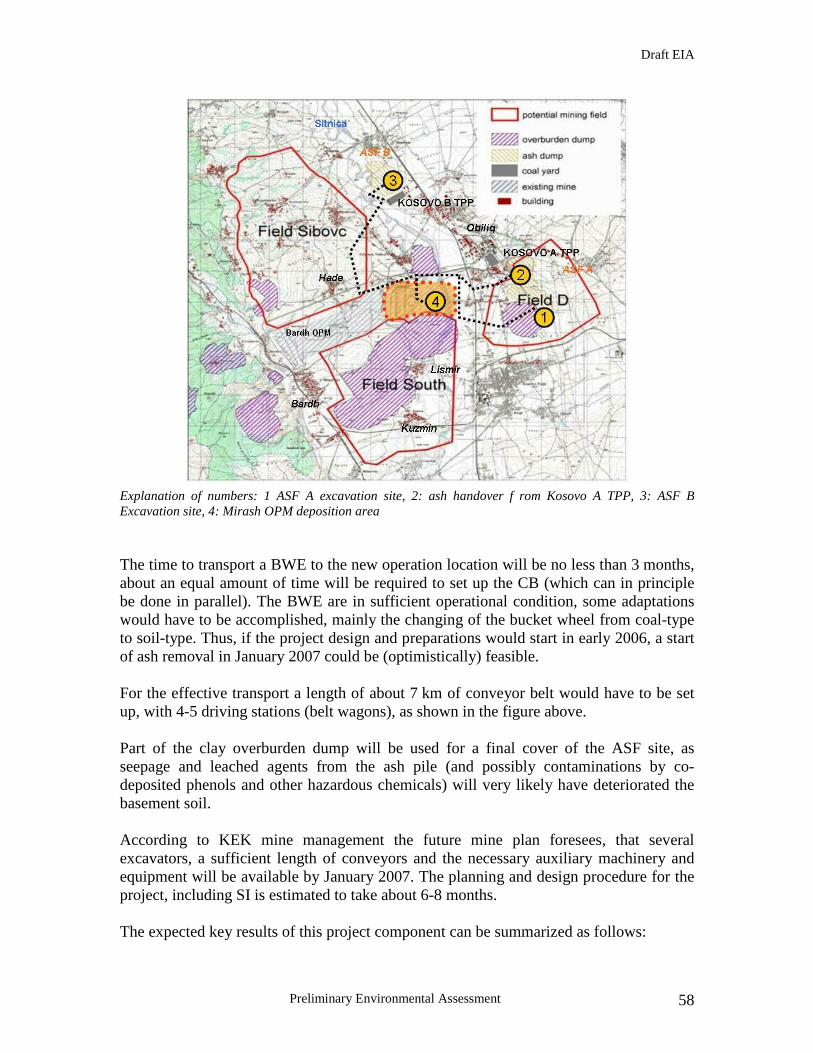
Draft EIA
Preliminary Environmental Assessment 58
Explanation of numbers: 1 ASF A excavation site, 2: ash handover f rom Kosovo A TPP, 3: ASF B Excavation site, 4: Mirash OPM deposition area
The time to transport a BWE to the new operation location will be no less than 3 months, about an equal amount of time will be required to set up the CB (which can in principle be done in parallel). The BWE are in sufficient operational condition, some adaptations would have to be accomplished, mainly the changing of the bucket wheel from coal-type to soil-type. Thus, if the project design and preparations would start in early 2006, a start of ash removal in January 2007 could be (optimistically) feasible. For the effective transport a length of about 7 km of conveyor belt would have to be set up, with 4-5 driving stations (belt wagons), as shown in the figure above. Part of the clay overburden dump will be used for a final cover of the ASF site, as seepage and leached agents from the ash pile (and possibly contaminations by co-deposited phenols and other hazardous chemicals) will very likely have deteriorated the basement soil. According to KEK mine management the future mine plan foresees, that several excavators, a sufficient length of conveyors and the necessary auxiliary machinery and equipment will be available by January 2007. The planning and design procedure for the project, including SI is estimated to take about 6-8 months. The expected key results of this project component can be summarized as follows:

Draft EIA
Preliminary Environmental Assessment 59
1. removal of ash as ongoing pollution source of air, surface water, adjacent land and groundwater
2. mitigation of geotechnical instabilities of the associated overburden dump
3. additional information gained on co-deposited phenol and other contaminants
4. access to ground and groundwater contaminations below ASF
5. availability of land for commercial / industrial purposes (this would be possible with some residual contamination levels)
6. freeing the D-Field for future Lignite mining development
It should be considered, that the post cleanup ASF site on D-Field will likely not be a green field suited for unrestricted subsequent use, e.g. resettlement or agriculture. This owes partly to the (suspected) phenol contamination, whichever degree it may eventually prove to be, partly to the (confirmed) former underground mine works, likely to cause stability and subsidence problems. Future mining scenarios should be integrated into a strategic approach to the cleanup of the ASF Kosovo A site. The removal of as much ash as possible is a key project result and undoubtedly will have a highly beneficial environmental impact on the area. But future remediation activities should be matched with potential lignite exploration scenarios. After decoaling Sibovc field, the D-field is the next choice regarding technical and financial feasibility. It thus would not make sense to restore the land currently occupied by the ASF to its original state, as in foreseeable future the are might be developed to a large open pit mine. Rather, the result should be an environmentally & geotechnically stable site with a clean surface and without harmful emissions into the environment, be it air, surface water or groundwater. If such a stable state is achievable after the cleanup operation, the Phenol contamination can remain in situ until mine development warrants removal and orderly disposal.
Redirection of ongoing ash production into Mirash OPM The continuation of ash deposition from Kosovo A TPP to the ASF should be phased out as soon as possible. As soon as the CB line from the ASF to Mirash OPM is set up, the existing CB for ash deposition should be linked to it. The linkage / handover of ash from he TPP could take place at an existing driving station at the ash CB, about due N of the old slurry ponds. An extra CB line would be installed back to the pit, following roughly the “coal railway”, heading W from TPP Kosovo A towards the NE corner of Mirash OPM. The direct disposal of the ash produced at Kosovo A TPP into Mirash could be installed and operated without interrupting or hindering either the current disposal method nor the future main disposal operation.

Draft EIA
Preliminary Environmental Assessment 60
The length of the required newly installed CB line would be around 2,500 m, with 2 driving stations (belt wagons) required. Also two bridges would have to be included into the CB system for rerouting the continuous ash production to Mirash OPM.
South and West Field overburden reshaping The overburden dumps have been deposited in its present state without any remediation measures several decades ago. During this period, the overburden has naturally compressed and flattened with slopes of circa 7°. The dumps mainly consists of a rib structure produced by the spreaders, some flat plateaus are evident throughout the overburden. The main priority of any works on the overburden dumps is to provide additional area for agricultural use. In general, the dump areas shall represent a high value landscape element in which agricultural use and habitat for local flora and fauna will exist in parallel. In order to achieve the above the following goals will need to be achieved:
• Ensuring a maximum possible inclination of 1:20 (3°), maximum 1:12.5 (4.5°), which allow for a cultivation with agricultural machinery
• Ensuring discharge of excess surface water by a minimum surface inclination of 1:200
• Collection and discharge of surface water by installation of ditches and storage basins and their connection to the existing rivers
• Installation of windbreak belts as a natural boundary for reducing wind erosion • Plantation of trees and shrubs for reshaping a varied landscape • Conservation of parts of the outside dump in the present form as refuge area for
the existing flora and fauna • Installation of access roads
A detailed landscaping and recultivation concept shall be prepared on the basis of a current survey of the entire dump areas. The flattening measures of the dozers are to be planned according to the dump design in sections. Thereby the masses can be distributed both slope down and upwards. After the levelling works have been completed, deep ploughing shall be carried out with a penetration depth of 0.5 m. In principal, soil-improving measures are not necessary for the proposed agricultural surfaces as the overburden material is suitably fertile. To increase fertility if required, it is possible to apply fertilising measures such as natural manures and sludges. However, such improvements lies within the scope of responsibility for the future owner and leaseholder. All access roads to and from the overburden areas shall be constructed as gravel made sand flushed roads with an average width of 4m. The following set-up of layers is recommended;
Draft EIA
Preliminary Environmental Assessment 61
10cm gravel base 0/32 mm, sand flushed 20cm gravel base 0/56 mm 30cm antifreeze layer 0/32 mm
Interim greening and erosion protection For the later management it is assumed that plots will have an average size of approx. 5-10 hectares. Provided that there is a rectangular sketch this corresponds to dimension of 500 * 150m. A windbreak belt shall be installed between the individual plots with a width of approx. 5m. Its function comprises both erosion protection and a natural boundary between the plots. A multi line arrangement of different wood is recommended. Fast growing species are especially suitable as windbreak belts, poplars for example, and bushes. It is suggested to install stone fruit meadows and/or carry out afforestation for steeper areas, where farming by means of machines will not be possible. Intermediate greening of the areas provided for an agricultural use aiming at an accelerated humus formation is not necessary owing to the high soil fertility of the dump site. Along the windbreak belts, ditches shall be installed for surface drainage. The size of the ditches shall be chosen in according to the respective catchments area. In suitable distances these ditches shall be widened to storage basins in order to be able to store the water for a limited period of time in case of heavy rainfalls. The single ditches shall be finally connected to collecting ditched discharging the yielded rainwater from the outside dump with a steeper gradient. These ditches shall be installed in a solid construction. The flow velocity of the water shall be reduced by means of check dams and stilling basins. An open ditch with downward gradient towards the Sitnica River shall be installed at the floor point of the outside dump The construction activities for the selected project alternative will take place in areas, which can be classified as totally environmentally degraded already (e.g., Mirash OPM as well as the Kosovo A ASF area and parts of the Kosovo A TPP perimeter). The construction will essentially involve the following activities:
1. Partial dismantling of bucket wheel excavators (BWE) at Mirash and Bardh OPM, transport through mine area and over agricultural land between Mirash OPM and Kosovo A ASF;
2. Dismantling of conveyor belts in Mirash OPM area;
3. Transport corridors for relocation of BWE from mine areas to Kosovo A ASF: Construction will involve removal of topsoil, excavation of near surface clay layer to an estimated depth of 1.0-1.5 m, refill of excavated area with road base (coarse gravel), compaction, construction of parallel drainage ditches;
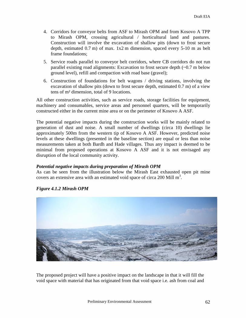
Draft EIA
Preliminary Environmental Assessment 62
4. Corridors for conveyor belts from ASF to Mirash OPM and from Kosovo A TPP to Mirash OPM, crossing agricultural / horticultural land and pastures. Construction will involve the excavation of shallow pits (down to frost secure depth, estimated 0.7 m) of max. 1x2 m dimension, spaced every 5-10 m as belt frame foundations;
5. Service roads parallel to conveyor belt corridors, where CB corridors do not run parallel existing road alignments: Excavation to frost secure depth (~0.7 m below ground level), refill and compaction with road base (gravel);
6. Construction of foundations for belt wagons / driving stations, involving the excavation of shallow pits (down to frost secure depth, estimated 0.7 m) of a view tens of m² dimension, total of 9 locations.
All other construction activities, such as service roads, storage facilities for equipment, machinery and consumables, service areas and personnel quarters, will be temporarily constructed either in the current mine area or on the perimeter of Kosovo A ASF. The potential negative impacts during the construction works will be mainly related to generation of dust and noise. A small number of dwellings (circa 10) dwellings lie approximately 500m from the western tip of Kosovo A ASF. However, predicted noise levels at these dwellings (presented in the baseline section) are equal or less than noise measurements taken at both Bardh and Hade villages. Thus any impact is deemed to be minimal from proposed operations at Kosovo A ASF and it is not envisaged any disruption of the local community activity. Potential negative impacts during preparation of Mirash OPM As can be seen from the illustration below the Mirash East exhausted open pit mine covers an extensive area with an estimated void space of circa 200 Mill m3.
Figure 4.1.2 Mirash OPM
The proposed project will have a positive impact on the landscape in that it will fill the void space with material that has originated from that void space i.e. ash from coal and

Draft EIA
Preliminary Environmental Assessment 63
soil overburden and will return the Mirash East open pit back to or close to its original form and contouring. At present the open mine area is covered by a thin layer of overburden and in many parts the coal seams are exposed. Furthermore spontaneous combustion in the void space is very much evident. As the area has been stripped of most of its overburden and combined with spontaneous combustion problems, it has not provided a natural habitat for flora and fauna. Some scrub is evident that has managed to impinge on what overburden remains. It is important to note that no closure plan was implemented for this opencast mine hence the conditions were not introduced to allow are enable natural re-cultivation in the area to any extent. As the natural habitat that existed prior to the mining activities at the Mirash mine have been completely decimated and destroyed, the proposed development to enable the mine receive the ask from both the existing ash dump and Kosovo A TPP, will have no impact on the ecology of the void space. Indeed it is important to point out that the impact of the development will be positive as once the void space has been backfilled the area will be closed and fully rehabilitated as part of a closure plan. This will enable the reintroduction of species into the area and the land will be made suitable again for amenity or agricultural use. Dust will be generated during relevant construction and engineering works in the preparation of the mine, mostly related to the mixing and disposal of ash. However such generation is expected to be minimal and temporary being directly linked to the time taken to prepare the mine for disposal and will not cause an increase in current dust deposition levels in the area. No dwellings lie within the environs of the Mirash OPM. Consequently, it is deemed that noise emanating from the Mirash OPM will have no negative impact on the environment. The overall groundwater flow regime around the present mining operations could be disrupted during preparation of the Mirash OPM due to the required construction activities. The detail EIA will analyze if this groundwater flow change could indeed take place based on a detailed drilling and sampling program. Potential negative impacts during relocation of Kosovo A ASF Noise could develop slightly negative environmental impacts due to the operation of the conveyor belts used to relocate the ash. It is necessary to locate these belts as far away as possible from the existing dwellings in order to avoid cumulative noise effects in the area during operations. The proposed new route for the ash disposal system i.e. the conveyor belts will be chosen carefully to have the least possible impact on the landscape using adequate screening and colouring. The adaptation of the ash disposal system will be done so in that it will have the least positive impact on the landscape. Screening will be put in place in the form of bushes were deemed to be necessary.

Draft EIA
Preliminary Environmental Assessment 64
Operations for the removal of the ash dump will be done in an environmentally friendly fashion with staff trained in the removal of the ash so as to have the least negative impact on the environment, in this case an increase in dust emissions. Dust will be primarily generated by excavation with the bucket wheel excavators, during ash transport with the conveyor belts and during an increase in traffic for construction purposes. However, due to the implementation of adequate mitigation measures, outlined below, in comparison to current dust generation and with the cessation of dumping there, the impact of the development on air quality is deemed to be minimal. Mitigation measures to keep dust emissions as low as possible during these activities are listed in the project environmental mitigation measures plan and include installation of an adequate sprinkler system, Cover for conveyor belts, and temporary cover of exposed ash material. The standard control and monitoring measures will be exercised during all activities. It is believed that the ASF poses a negative impact on surrounding soils due to mining activities such as follows:
• The soil underneath ASF is degraded by alien chemistry of ash
• There is a potential contamination of soil and deeper ground at ASF by hazardous chemicals co-deposited with ash;
• degradation of soils in ASF vicinity by runoff, washed out ash and wind blown particle transport.
During preparation for the ash relocation and the operation itself the following negative environmental impacts could be developed such as destruction of surface soil layer due to CB alignment and BWE haulage corridor construction as well as due to possible spills and dust emissions from CBs.
Furthermore, hazardous organic materials could be released during excavation works if chemicals have been disposed of in barrels in the ASF. One current drilling campaign including analysis of 36 soil and ash samples showed no threat of phenol/hazardous organics contamination since their concentration have been found constant and within the acceptable limits. However, a detailed sampling program will confirm this during the development of a detailed EIA once project starts implementation. Potential negative impacts during reclamation of overburden dump Indeed the overall impact would be positive as the areas in question would once again be suitable for agriculture, thus bringing the areas back to the landuse prior to the commencement of mining activities in the area. The reshaping and grading will have a minor temporary impact on the current vegetation that has managed to recolonise the area. With a proper and comprehensive reclamation plan for the land covered by the ash, the reintroduction of native plant and animal species into the area will be possible. Thus any impact on the ecology of the overburden dumps will be temporary while providing a suitable habitat on completion that would previously have existed prior to dumping of overburden in the area. Reshaping and re-grading of the overburden dumps will have a temporary minimal impact on air quality mostly resulting from dust generation from bulldozer operation and
Draft EIA
Preliminary Environmental Assessment 65
earth moving as well as emissions from construction machinery. However, the reshaping and re-grading may have negatively affect the surface water quality due to the potential for an increase in sediment transport by runoff from the overburden dump during the construction phase. Construction noise levels emanating from proposed works at the overburden dumps is considered to be minimal and within the acceptable standards. Furthermore, the reshaping activities planned under the project could cause the disturbance of the original soil stratification and damage the surface soil layer. Overall the impact of the proposed project activities on soil is positive in a long term since the land gain for the formation of new topsoil will be considerable (about 4 km² at the South Field Dump, about 2 km² at the Kosovo A ASF). Potential negative impacts of packing and transporting hazardous materials:If the project will involve the phenol and hazardous materials removal operation the affiliated construction activities would involve demolishing works, earthworks and heavy transport activity confined to the perimeter of the former gasification plant adjacent to Kosovo A TPP. The main technical risk associated with the proposed remediation options is the possible alleged phenol contamination under Kosovo A ASF during the noted removal activity. The current state of information does not allow any estimate of the contaminated materials or the physical extent of the contaminated zone(s). The risk associated with phenol contamination could include:
• Phenols or phenol-water solutions and other residuals from the gasification plant disposed in containments (e. g. barrels) in the ASF, at its foundations or in old mine works underneath. These will be very hard to locate, as they will be covering a small area and possibly not cause ongoing emissions.
• Loose, disseminated phenol contamination of deposited ash material and ground immediately underneath ASF
• Loose, disseminated phenol contamination of ground and potentially coal seams in greater depth (several 10s of meters) underneath ASF
• Groundwater contamination in one or more aquifers underneath ASF, with continuous phenol discharge from source(s) and formation of a contamination plume(s) downstream of ASF
One of the most important risk scenarios is the encounter of phenols or other by-products and residual chemicals resulting from the coal gasification process. For this case the disposal of ash into Mirash OPM could be tolerated up to certain contamination levels, which would have to specified with clear MAC4 values. Even with low concentrations the long term safe storage would have to be ensured by appropriate technical measures in the Mirash OPM as well as a monitoring concept to
4 maximum allowed concentrations

Draft EIA
Preliminary Environmental Assessment 66
exclude harmful emissions particularly into the groundwater. The following potential measures are regarded necessary: • deposition cells to be constructed from low permeability materials (clay) and
properly engineered (dimensions, compaction) enclosing contaminated materials from all sides
• material properties of cell construction materials to be tested (permeability coefficient, density, plasticity index, cohesion, internal angle of friction, unconfined compressive strength, deformation modulus)
• hydrogeological model projecting future GW dynamics after completion of deposition and termination of GW lowering by pumping, supplemented with a contaminant transport model
• elaboration of GW monitoring concept including necessary number of observation wells, technical equipment (piezometers, automatic loggers, data transmission), stocktaking of installed and construction (drilling) of required new wells
• elaboration of analytical monitoring concept, incl. list of parameters, analytical procedures, sampling and analytical intervals
• definition of contaminant threshold values, response plan in case of exceeding
Standpipes equipped with piezometers and offering the possibility of extracting GW samples should also be installed directly in the ash disposal cells for continuous monitoring of the state of the disposed materials inside the disposal cells. The potential budget consequences could be significant, especially when larger parts of the ash are found to be contaminated with phenols or other harmful substances. While the disposal of low contamination ash into Mirash OPM would probably increase disposal cost per ton around 20% (including modification of cells, analytical and monitoring procedures), an off site disposal would more drastically increase cost. Current market prices for the disposal of tarry residuals (i. e. from the gasification of coal), such as phenols, PAHs and aqueous solutions thereof, range from 500 �/t to 850�/t.For phenol contaminated ground from these figures will likely be lower, ranging from 150 �/t to 250 �/t, but will show high fluctuations5.
These above given figures will in any case have to be verified during the elaboration of a detailed remediation and disposal concept by a thorough market research and the solicitation of quotations by qualified waste management firms. But they give an idea,
5 depending on level of contaminant concentrations, properties of ground (usable e.g. as engineering
material in waste dumps?), chosen disposal route (dumping, thermal / biological cleaning?).
Draft EIA
Preliminary Environmental Assessment 67
what the cost increase could be if (only) a few 1,000 t have to be disposed off site as hazardous waste and cannot be backfilled into Mirash OPM. While a significant phenol contamination appears less likely for the relatively young ASF sectors E and W (the 40-50 m high parts of the ASF in the S sector), the lower, older sectors closer to the TPP are more likely to harbour problems.
PROJECT STRATEGY IF ENCOUNTERING PHENOLS
The uncertainty about the contamination situation stresses the very high importance of careful investigations prior to the remediation works and the preparedness to deal with the phenol contaminations potentially encountered during cleanup operations. However, it is important to make a clear point regarding the project goals: The CLRP’s main objectives are land reclamation and the elimination of grave environmental nuisances caused by the ASF (dust generation, geotechnical stability problems, surface water contamination, aesthetic degradation of landscape). This will be achieved by the proposed backfill operation. To simultaneously tackle and solve the problem of the (potential) phenol contamination is not within the scope of the CLRP, as the investigation and design for the cleanup operations would put the operation into a much longer timeframe and, possibly, dimension of cost. The general strategy of the proposed project regarding the Phenol contamination should therefore be to remove as much ash as possible, leave the site as stable, clean and environmentally friendly as possible, but at the same time touch the Phenol problem as little as possible. This would imply the following specific approach / strategy:
1. See the investigation campaign mainly as generation of information and design parameters for ASF removal, not as complete basis for a design for the partial or complete remediation of the phenol contamination.
2. Continue investigations regarding the quantity and distribution of phenols in and / or under the ASF during the cleanup operation to gain a precise picture of the contamination.
3. Remove only minor phenol contaminations during the CLRP, which can be deposited in the specially prepared cells in Mirash OPM, and this only if it cannot be avoided (by, e.g. leaving minor contaminations on site, levelling and covering them).

Draft EIA
Preliminary Environmental Assessment 68
4. Leave all Phenol contaminations at the base of or in the ground below the ASF in situ, do not open a “second front” within the CLRP.
5. Leave the site levelled and (if necessary) with a sufficient capping (from locally available clayey materials), adapted to the contamination situation encountered during cleanup operation.
6. Perceive the detailed information gained on the phenol contamination during preparation and implementation of ASF removal as an important additional output / result of the CLRP. With this information a subsequent project aimed specifically at the remediation of the phenol contamination can be planned under different parameters regarding funding and timeframe.
Impacts on Receptors
Impacts on Human Health and Socio-Economics
Cleanup workers are at the highest risk of all receptors of the impacts of the proposed project. Their close proximity to removal, transport and disposal of ash operations greatly increases their risk of inhalation of airborne particulates containing ash compounds and dermal exposure to hazardous compoundons such as heavy metals (cadmium, arsenic, mercury, lead, cromium, polyaromatic hydrocarbons, phenols). More detail on the impact of these toxic substances on human health is provided in the above section. Special precautions to prevent or reduce these impacts are described in Section 6, Mitigation Measures, in the Environmental Management Plan. There are no known special or protected cultural properties or indigenous peoples in the immediate vicinity of the cleanup sites identified to date. However, if new cleanup sites are identified as objective of this project and sites are further assessed and cleaned up, the cleanup program should remain vigilant for the possibility that such resources may be discovered and would need to be protected. A "chance find" protocol should be developed at the detailed design stage for utilization during project implementation. The preparation of the Mirash OPM will have no adverse impacts on human beings. Its development will have a positive impact providing necessary employment during preparation and operation of the disposal area. The expenditure on the preparation and operation will have a positive economic benefit on the surrounding economy. Preparation will have no adverse impact on public safety. The relocation of Kosovo A ASF will have no adverse impacts on human beings. Its development will have a positive impact providing necessary employment during the removal of the ash. The expenditure on the preparation and operation will have a positive economic benefit on the surrounding economy. Preparation will have no adverse impact on public safety.

Draft EIA
Preliminary Environmental Assessment 69
There will be a significant positive impact on public safety. Currently the western tip is a major source of concern particularly with respect to geotechnical stability and currently collective ash tip and mine overburden tip movement is having a negative impact on neighbouring properties and infrastructure. The complete removal of the ash dump would eliminate this current problem. The reshaping and grading will have no adverse impact on human beings. It will provide agricultural land to the local population providing a positive impact on rural employment in the area. The expenditure on the project will have a positive economic benefit on the surrounding economy during project construction/development. The proposed Project will be positive for the local and national economy providing much needed employment both directly and indirectly. Impacts on Natural Ecosystems The impacts to natural habitats that could result from implementation of the selected alternative for ash cleanup could include the following organisms and medium to be affected: (i) Soil inhabitants due to additional contamination of soils by phenol or hazardous materials on the construction site; (ii) microorganisms present in soil and water due to destruction of habitat and disturbance of biological cycle.
Conclusions The primary objective of the proposed project is reduction of environmental degradation, so it is anticipated that the project will result in significant net positive environmental impacts. The pre- FS selects a preferred cleanup alternative by determining which approach minimizes the risk associated with the residual negative impacts after cleanup. The residual risk depends on the cleanup action and target levels selected, the effectiveness of the cleanup, and the accuracy and precision of testing to locate contamination and measure cleanup effectiveness. This complexity makes it difficult to predict precisely, with the available data and analysis, how much risk will be reduced and how much will remain at each individual cleanup site. However, in general, the selected alternative would result in significant net positive impacts to environment and human health, as follows:
• Significant long-term reduction in the release of ash-related compounds to air from the sites cleaned up by the project;
• Significant long-term reduction in inputs of ash-related compounds to the Sitnica River and thus reduction of mercury transfers from the river to the surroundings and further down to Danube River;
• Significant long-term reduction in possible release of ash-related compounds to groundwater, from the sites cleaned up by the project;
• Reductions in contamination risks to drinking water, agriculture, recreation and surrounding habitats;
• Significant improvement in the health of people, socio-economy and ecosystems in the area
However, the project intends to address the cleanup of toxic hazardous chemicals (e.g., phenols) that could persist and/or become mobile in all environmental media - air, surface water, soil and groundwater. For this reason, some adverse impacts to human health and

Draft EIA
Preliminary Environmental Assessment 70
environment are possible and should be evaluated during the development of a detailed feasibility study. Although there is insufficient data presented or analyzed in the pre-FS to determine site-specific negative environmental impacts related to packing and transport of hazardous chemicals, these impacts are mostly short-term and minor increases in transfers of these contaminants to air, surface water or groundwater through inadvertent releases incidental to the waste removal, transport and disposal process.

Draft EIA
Preliminary Environmental Assessment 71
5.0 ANALYSIS OF ALTERNATIVES The following theoretical alternatives were identified for the main project components in the pre-feasibility study. Since the project is an environmentally beneficial cleanup, all alternatives proposed in the pre-FS should result in net positive environmental impacts. Therefore, this pre-EIA focuses on the review of whether the alternatives analysis is thorough; addresses technical, economic, social and environmental criteria; and provides alternatives for design, location, technology. Kosovo A ASF
1. Do nothing, continued operation of ash deposition system: this alternative would allow the current environmental burden (for landscape, air quality, adjacent soils, surface and groundwater, health and safety of neighbouring population) continue unabated and, by adding more ash every year, even exacerbate the negative impacts. For this reasons the “do nothing” option was discarded under the project framework.
2. Do nothing, but stop ongoing deposition: this option would allow the current, negative environmental impacts of the ASF to continue unabated, while at least preventing deliberate exacerbation. However, the current state of the ASF has been recognized as environmentally intolerable, thus even without worsening of the situation the there is sufficient rationale to discard this option.
3. Discontinuation of ash deposition, reshaping and greening of the ASF: this alternative would mitigate some negative impacts of the ASF:
a) dust emissions would be curbed
b) the optical aspect of the landscape would be improved
c) effects on surface drainage by runoff and washout would be mitigated.
However, a number of negative impacts would continue unchecked and continue to be a major nuisance and risk:
a) the geotechnical instabilities of the overburden underlying the western tip would continue unmitigated
b) no contribution to levelling the backfill balance for Mirash OPM would be made
c) the area occupied by the ASF would continue to offer very limited options for future use, in fact the aspect of land reclamation would not be realized
d) no future mine developments in the economically interesting D field would be possible with the ASF remaining in place
e) further investigations and access of the potential Phenol contaminations under the ASF would be distinctly more difficult.
Draft EIA
Preliminary Environmental Assessment 72
Moreover, a reshaping and greening project has been implemented on the eastern part of the ASF with limited success. The chosen plants did not grow as expected and much of the surface remains barren. Still it has to be conceded, that the eastern part of the dump is in perceptibly better condition than the completely untreated western part.
Mirash OPM
1. Do nothing: There are several geotechnical, hydraulic and environmental problems associated with the current state of Mirash OPM, which would continue unmitigated without the CLRP:
a. water ingressions from Sitnica river
b. self ignition and incineration of coal
c. geotechnical instabilities of the pit walls
d. dust generation from the exposed slopes
e. large void in the landscape with a lasting mass deficit
While each of the above points could probably be addressed with appropriate single technical measures, the positive synergetic effect the ash disposal in Mirash OPM would exert, would be missed entirely. Thus this alternative was dismissed by the project.
2. Use as landfill for external waste: To reduce the mass deficit within the OPM external waste (soil and earth, riprap, construction waste, industrial and municipal waste) could be introduced into Mirash OPM (in fact, one pilot project is currently in operation). However, besides again missing the positive synergetic effect there would be a number of disadvantages:
a. waste will likely not have the beneficial geotechnical properties of ash and clay
b. waste might contain harmful substances and would have to be rigorously controlled
c. rise of groundwater in the OPM would carry the risk of leaching and transporting harmful substances from waste
d. licensing procedure would be very complex, especially with regard to EU regulations for waste deposits
With regards to above risks and disadvantages this option was considered interesting as a small scale supplement to the proposed backfill operation, but not as a main solution for mine backfill. Overburden Dump
1. Do nothing: this option would not constitute any environmental risk, as it has been continuing for several decades. However, this option would be entirely besides the point, as one of the main project goals is to fee land for future use,

Draft EIA
Preliminary Environmental Assessment 73
either for agricultural purposes or as residential areas. The South Field Dump has been partly converted into agricultural land in the areas most accessible and, by their slope angles, easily arable. However, large parts of the dump still remain unused and could be converted into a much better quality land. The wider benefit of this option would be to free land elsewhere for residential developments.
2. Refill into Mirash OPM: As the land quality of the overburden dump is currently tolerable, this would be a marginal improvement only. The cost, on the other hand, would be extreme, resulting in a very poor cost/benefit ratio. As the coal seams tend to dip southward rather steeply in the South Field, the argument relating to future mine development is rather weak.
In Situ Remediation of the Kosovo A and B Ash Storage Facilities (ASF): Remedial measures , as an alternative to ASF removal, would include reshaping, landscaping, establishing stable slope gradients, top-soiling (using overburden from adjacent dump), vegetation, erosion control measures, surface and perimeter drainage systems, water treatment plant, groundwater monitoring system. This option however would pose a continued threat of groundwater contamination, potential uncontrollable geotechnical instabilities and a lack of sustainable utilization scenarios, except for grazing and gardening. In addition the possibility of investigating and possibly remediating the Phenol contamination suspected in old mine works under the ASF would be more difficult.
Complete Removal of the Kosovo B ASF: The conveyor alignment for feeding lignite to the to the Thermal Power Plant (TPP) is close to the ASF of Kosovo B and could potentially be fitted with an additional line to transport material back to the OPM. Due to the wet deposition method ongoing for several years, the geotechnical stability appears generally better and the surface is hard and cemented, therefore being much less of a dust generation and groundwater problem. However the cemented ash would be harder to remove, transport and handle than the soft ash from the Kosovo A ASF. In addition, the land reclamation and visibility aspects would be less important.
Rehabilitation of the Kosovo B Waste water treatment plant: As a standalone project the rehabilitation of the wastewater treatment plant is not the optimum solution. The plant poses no significant environmental risk to justify major interventions. There is no significant area of reclaimed land, and its vicinity to Kosovo B does not allow for any subsequent utilization scenario. Furthermore the work would yield a relatively low positive environmental impact except if it were carried out in combination with Kosovo B ASF in situ remediation.

Draft EIA
Preliminary Environmental Assessment 74
Removal and Disposal of Hazardous Materials out of Kosovo Due to soil contamination and the presence of hazardous materials, the former gasification plant at Kosovo A TPP site is considered one of the most hazardous hot spots in the KEK portfolio having both the most tangible negative impact and the highest level of risk. In order to address this environmental issue, the following cleanup solutions have been analysed by the pre-EIA:
1. Removal, transport and disposal of all potentially hazardous materials off site
(preferred solution)
• Disposal for Option 1 may involve transfer of ownership of phenols to relevant company or industry e.g. Slovenia or Germany. Coal tars, oils etc will still need to go to a recognised hazardous waste facility
• Disposal for Option B may involve removal of all materials including phenol to a recognised hazardous waste facility
• Removal and transfrontier shipment of materials will need to comply with all relevant legislation, permitting and licensing requirements
2 Separation of Phenolic Water
• 80m3 of Disopropyl ether purchased as catalyst for separation process at cost of
140,000 euro • Hazardous material in its own right • Technological steam required for process • Heating plant not in operation • Currently not possible to receive technological steam from Kosovo A power
station • Even if it was possible to separate phenolic water KEK would still be left with
8,000 – 9,000m3 of heavily contaminated waste water • Facilities currently in place not up to required standard to treat this
contaminated/waste water adequately thus providing a further potential environmental threat
• Removal and transfrontier shipment costs would remain the same regardless of whether the Phenol was separated
• Cost of separation may prove to be as costly as disposal (due to current disrepair of required facilities) thus eliminating any potential savings
• Companies unwilling to pay for material
3. Make secure hazardous waste storage facility in the short term
• Could prove costly but delaying the inevitable problem of having to remove waste off site eventually.
Draft EIA
Preliminary Environmental Assessment 75
6.0 ENVIRONMENTAL MANAGEMENT PLAN
6.1 Mitigation Strategy Each site cleanup should be designed and carried out with adequate mitigating measures and emergency response procedures to avoid inadvertent short-term releases to other environmental media, and hence to remediation workers, nearby residents and sensitive species, habitats and ecosystems. It is believed that all of these impacts can be avoided or mitigated to a large extent through implementation of the EMP which includes physical measures to prevent, minimize, monitor, contain or otherwise respond to releases during and after remediation. Ecology Proposed mitigation measures to reduce negative impacts of the project construction activities on ecology are listed below:
• For any temporary disturbance during excavation works and ash removal such as dust emissions, sprinkler systems will be utilized;
• For the rerouting of the ash disposal system, the most optimum route will be chosen that will have the least impact on ecology;
• Machines will be fueled at secure designated areas Air quality Proposed mitigation measures to reduce negative impacts of the project construction activities on air quality are listed below:
• Installation of sprinkler system at disposal area • Temporary cover of exposed clay material; • Exercise normal C&M of plant being used at the site • Exposed ground will be avoided during transfer of clay as much as possible; • Transport routes and site will be sprinkled with water during dry weather • Cover for conveyor belts will be used; • Site roads will be correctly laid and covered.
Noise To mitigate possible negative impact generated by noise the following steps will be followed:
• the conveyor system will be properly maintained and managed to avoid increases in noise levels resulting from lack of maintenance;
• All movement of trucks, loaders, etc to and from the sites i.e. Mirash OPM, Kosovo A ASF and the overburden dumps will be done during daytime (normal working) hours and will be kept to a minimum;
• All vehicles and mechanical plant will be fitted with effective exhaust silencers and maintained in good working order
• Machines that are used intermittently will be shut down or throttled back to a minimum during periods when they are not in use.

Draft EIA
Preliminary Environmental Assessment 76
Soil The negative construction impacts on the soil for the relocation of Kosovo A ASF should be mitigated as follows:
• Destruction of surface soil layer by CB alignment and BWE haulage corridor construction:
o keep all earthworks to a necessary minimum
o carefully remove topsoil and store for reuse after dismantling of CB after conclusion of project.
• Spills and dust emissions from CBs causing soil alteration and degradation in the immediate vicinity:
o transport ash in a moist state to avoid dust generation (by sprinkler installed when CB leaves ASF area)
o avoid overloading CBs to prevent material falling off
o regularly clean CB corridor from fallen off materials
• Increased dust generation during excavation activities at ASF causing soil alteration and degradation in the immediate vicinity
o use sprinkler systems to curb dust generation during dry weather conditions
Groundwater The negative construction impacts on the groundwater during the preparation of Mirash OPM are listed below:
• In any case the project concept foresees the installation of a mineral (clay) barrier at the bottom of Mirash OPM, and the deposition of all materials within cell structures constructed of locally available clay.
• Accidental relocation of ground contaminated with phenols / other chemicals: The proposed mitigation measures consist of four aspects:
o Preceding investigations to identify any major quantities of contaminated soils or stored chemicals, localize them and plan the excavation procedures accordingly.
o Organoleptic and, if required, analytical control during excavation to identify any encountered contaminated material without delay and organise the appropriate action, such as analyses, classification and required deposition pathway.
o Definition of maximum allowable concentrations to be deposited in Mirash OPM: agree with authorities on the maximum concentrations in ash and clay materials, which can be stored i) without special provisions, ii) in specially prepared cells, iii) not at all in the OPM but have to be stored temporarily for later disposal.
Draft EIA
Preliminary Environmental Assessment 77
o preparation of a special storage cell for receipt of contaminated materials, which is equipped to accommodate contaminated soils of category ii) above.
• Accidental spillage of fuels on site: Establish and enforce safe driving rules in the
whole project area to minimize the risk of accidents; provide dedicated fuelling and service locations for all machinery, establish and enforce clear, safe rules for the refuelling of earth moving equipment (excavators, bulldozers), using specially equipped vehicles to carry and dispense fuels. Disallow and prosecute improvised re-fuelling from canisters, barrels and other unsafe containers. Ensure safety standards for central project fuel storage, or rely on the existing infrastructure of KEK.
The negative construction impacts on the groundwater during the relocation of Kosovo A ASF are listed below
• Contamination of groundwater by phenols and other chemicals co-deposited at the ASF: Ensure that excavation works in potentially contaminated zones are accomplished in dry weather conditions to avoid transport by infiltration and seepage of precipitation. Overall, however, a distinct net risk reduction and mitigation for the groundwater underneath the ASF is expected.
• Chemicals stored in barrels cracked open during excavation works and chemicals released: Try to locate potential barrel deposits during preceding SI (e. g. with geophysical methods). Have observer helper near bucket wheel during excavation in known risky areas. Instruct BWE operators to immediately stop excavations in case of any conspicuous circumstances or objects encountered. Have safe storage area ready for intermediate storage of encountered chemicals containments.
• Increased seepage from ASF during removal: ensure proper temporary perimeter drainage for working areas as well as favourable gradients for surface drainage during excavation works. Avoid depressions or flat areas on exposed ash, where puddles and ponds might form.
Surface waters The mitigation measures proposed to reduce the negative impacts on surface water include the following activities:
• Install interception drainage system and water treatment plant (sedimentation pond) at Kosovo A ASF
• Install casing on conveyor belt bridge over Sitnica River • During moving the bucket wheel excavator, ensure that transport is done when the
Sitnica River is at its lowest point • Install drainage system and sedimentation system at the overburden dumps
Mitigation actions related to phenol contamination during transport of hazardous materials outside of Kosovo
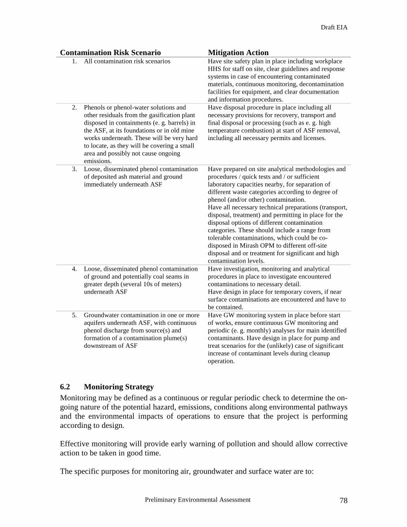
Draft EIA
Preliminary Environmental Assessment 78
Contamination Risk Scenario Mitigation Action 1. All contamination risk scenarios Have site safety plan in place including workplace
HHS for staff on site, clear guidelines and response systems in case of encountering contaminated materials, continuous monitoring, decontamination facilities for equipment, and clear documentation and information procedures.
2. Phenols or phenol-water solutions and other residuals from the gasification plant disposed in containments (e. g. barrels) in the ASF, at its foundations or in old mine works underneath. These will be very hard to locate, as they will be covering a small area and possibly not cause ongoing emissions.
Have disposal procedure in place including all necessary provisions for recovery, transport and final disposal or processing (such as e. g. high temperature combustion) at start of ASF removal, including all necessary permits and licenses.
3. Loose, disseminated phenol contamination of deposited ash material and ground immediately underneath ASF
Have prepared on site analytical methodologies and procedures / quick tests and / or sufficient laboratory capacities nearby, for separation of different waste categories according to degree of phenol (and/or other) contamination. Have all necessary technical preparations (transport, disposal, treatment) and permitting in place for the disposal options of different contamination categories. These should include a range from tolerable contaminations, which could be co-disposed in Mirash OPM to different off-site disposal and or treatment for significant and high contamination levels.
4. Loose, disseminated phenol contamination of ground and potentially coal seams in greater depth (several 10s of meters) underneath ASF
Have investigation, monitoring and analytical procedures in place to investigate encountered contaminations to necessary detail. Have design in place for temporary covers, if near surface contaminations are encountered and have to be contained.
5. Groundwater contamination in one or more aquifers underneath ASF, with continuous phenol discharge from source(s) and formation of a contamination plume(s) downstream of ASF
Have GW monitoring system in place before start of works, ensure continuous GW monitoring and periodic (e. g. monthly) analyses for main identified contaminants. Have design in place for pump and treat scenarios for the (unlikely) case of significant increase of contaminant levels during cleanup operation.
6.2 Monitoring Strategy Monitoring may be defined as a continuous or regular periodic check to determine the on-going nature of the potential hazard, emissions, conditions along environmental pathways and the environmental impacts of operations to ensure that the project is performing according to design. Effective monitoring will provide early warning of pollution and should allow corrective action to be taken in good time. The specific purposes for monitoring air, groundwater and surface water are to:

Draft EIA
Preliminary Environmental Assessment 79
• Define baseline (background) air and water quality and physical conditions in the
atmosphere and surrounding groundwater and surface water • Allow assessment of compliance with site licence conditions • Provide confirmation that the engineering measures are controlling emissions as
designed • Provide information about the processes occurring within the ash disposal site • Provide information on the state and rate of stabilisation of the ash body for
comparison to the design lifetime of contaminant and monitoring systems • Provide an early warning of any departure from design conditions • Provide an early warning of adverse environmental impacts • Provide an early warning of breach of regulatory standards • Provide information to enable decisions on the management of the site to be taken • To provide information to support an application for certificate of completion
Data gathered during the monitoring programme needs to be reliable and fit for their intended purpose. Quality assurance (QA) and quality control (QC) are assumed to be incorporated into all elements of the development of monitoring infrastructure and monitoring programme. The monitoring programme for the project can be divided into four categories:
• Initial characterisation monitoring • Routine monitoring • Assessment monitoring • Completion monitoring
Initial characterisation monitoring Initial characterisation monitoring is a period of monitoring to define the normal range of variation in the air and water. The frequency and range of monitoring data collected need to be sufficient to be able to characterise seasonal and other non project influences. A broad range of measurements is required. The initial characterisation monitoring will be completed prior to commencement of the project operations i.e. during the comprehensive EIA. Routine monitoring Routine monitoring of air and water is undertaken to maintain continuity with the initial characterisation monitoring programme and to concentrate effort on comparing the performance of project operations with specified conditions. Routine monitoring can be divided into two parts as follows:
• Indicator measurements: to provide more frequent monitoring of measurements specified for compliance purposes

Draft EIA
Preliminary Environmental Assessment 80
• Ongoing characterisation measurements: a periodic repeat of the same measurements that were undertaken during the initial characterisation monitoring programme but at a lesser frequency.
Assessment monitoring Assessment monitoring may include a combination of a greater intensity of monitoring (e.g. more frequent monitoring combined with an increased range of measurements) or site investigation. The need for assessment monitoring could be triggered by a number of situations. For example, where significant departures from baseline or design conditions are identified, or where a greater degree of monitoring information is needed to define natural attenuation and mitigation processes.
Completion monitoring Completion monitoring is part of a process conducted towards the end of the project in order to demonstrate that the Mirash OPM is no longer capable of harming human health or the environment. All monitoring data collected over the period of the project will form an essential part of the detail needed to demonstrate completion conditions. A completion report will be submitted on completion of the project to demonstrate that the stabilisation of the Mirash Ash Disposal area has been achieved. This will be carried out as part of the closure plan for Mirash OPM when the void capacity is reached.
The site which is to be monitored will not be allowed to commence operations without the results of the risk based monitoring review and the initial monitoring programme, which will be submitted as part of a detailed EIA, to the MESP. All external monitoring infrastructure necessary to monitor the sites will be in place and approved by the MESP as part of its acceptance of the work plan.
6.3 Content of the Site Monitoring Plan The site monitoring plan will be composed of two main sections:
• The main document specifying objectives, design details and procedures to be adopted for site monitoring
• A series of technical appendices collating the information and data needed to understand and interpret monitoring information.
The site monitoring plan will incorporate specifications to include the following issues;
• Management structure and technical competence • Monitoring objectives

Draft EIA
Preliminary Environmental Assessment 81
• The number and location of monitoring points • Monitoring measurements • Monitoring schedules • Assessment criteria and contingency actions • Design of monitoring points • Monitoring methodology • Data management and reporting procedures • Quality assurance including quality control measures
Some of the above issues will need to be considered simultaneously, though the sequence given is recommended in order to fully address all monitoring issues. Technical reference information needed for the monitoring programme should ideally be collated into a digestible format within the site monitoring plan for reference by site monitoring personnel and the MESP. The objective of collating information is to provide in one single, updated document all necessary information for monitoring including:
• Summary of risk based monitoring strategy • Monitoring infrastructure details • Sampling protocols • Baseline data summaries
The site monitoring plan will identify the person responsible and the management structure in place for delivery of the plan. This will include the mechanisms for liaison between the different people and the MESP. Monitoring is a multidisciplinary scientific activity requiring a variety of inter-related managerial and technical skills. Whilst many routine tasks can be undertaken by personnel with a basic scientific background, there will be a need for appropriate training in monitoring and quality control procedures to reinforce the basic knowledge. There will be a need during the development and implementation of the monitoring programme for the involvement of a number of different personnel with specific technical competencies. The use of inexperienced personnel on the monitoring programme without prior experience will not be acceptable.
Monitoring measurements
• The site monitoring plan will include tables specifying: • Monitoring measurements to be undertaken • The units of measurement • The tolerable uncertainty

Draft EIA
Preliminary Environmental Assessment 82
• The detection limit (where appropriate) • The analytical method
The selection of monitoring measurements will be related to the characteristics of the ash. The final choice of measurements is site specific and subject to the results of the risk-based monitoring review. Periodic review of the selection of monitoring requirements will be undertaken. After initial characterisation is complete, a range of indicator measurements may be selected for use as part of the routine monitoring programme. Monitoring measurements can be sub-divided into the following broad categories:
• Observational and physical instruments • Principle chemical composition measurements • Minor chemical measurements • Biological measurements
Groundwater The behaviour of groundwater is a complex subject forming a science in its own right. Once leachate emerges through the base of the disposal area, it will begin to disperse. The direction and rate of this dispersal will be determined by:
• The properties of the soil or rock (geology) • The prevailing groundwater flow conditions (hydrogeology) • The presence of man made or natural voids
An understanding of the geology and hydrogeology is essential to be able to determine contaminant flow paths and flow rates, which will in turn be used to decide on monitoring locations and frequencies. In terms of groundwater flow, the subsurafce may be divided in general into two generalised physical zones:
• The unsaturated zone (above water table) • The unsaturated zone (below water table)
Water movement through the unsaturated zone is predominantly downward until it reaches the water table. Flow through the saturated zone will follow the prevailing groundwater gradient. In granular formations without fissures or conduits, unsaturated zone flow is commonly much slower than saturated zone flow, though flow rates can still vary over several orders of magnitude. When fissures or conduits are present, flow rates can approach those found in surface waters. Monitoring of the unsaturated zone may be used to provide warning of an impact on groundwater in the saturated zone, though the design, construction and maintenance of reliable monitoring systems are problematic. It is likely that the primary groundwater monitoring systems at the sites in question will be located within the saturated zone.

Draft EIA
Preliminary Environmental Assessment 83
Number and location of groundwater monitoring points If risk assessment will not been used for positioning boreholes, the following guidance swill be followed when determining the minimum number of groundwater monitoring points required at the sites, in particular the Kosovo A ash dump and the Mirash OPM:
• All sites where groundwater monitoring is specified: at least three groundwater monitoring boreholes are required per groundwater system of which one should be up-gradient of the site and two down gradient
• Sites at which receptors are at a higher risk: additional boreholes on site boundary
Monitoring Frequency The following is the suggested monitoring regime for a new landfill. It is proposed to apply the same criteria to this project. The following guidance is given by the UK Environmental Agency:
• For most landfills, initial characterisation monitoring should be undertaken for at least one year prior to landfill development, and wherever possible, for a longer period
• For sites that can be demonstrated to pose low risks to receptors, initial characterisation monitoring should start at least 3 months prior to deposit of wastes and may be completed following commencement of waste input
• The monitoring frequency used during initial characterisation monitoring period should be sufficient to characterise seasonal variation. Normally quarterly or more frequent (e.g. monthly) sampling will be required
• In the absence of information to support alternative strategies, at least 16 sets of data should be obtained per uniform water body. Lesser requirements would only be acceptable where data are demonstrated to be statistically valid for their intended purpose
• Where water characteristics are uniform in a water body, samples could reasonably be obtained from a combination of several monitoring points. For example:
o 4 monitoring points could be monitored quarterly to obtain 16 samples within a 1 year period
o 3 monitoring points could be monitored every 2 months to obtain 18 samples within a 1 year period
• For situations where local variations in water characteristics are present, initial characterisation monitoring will need to very carefully planned for each monitoring point in order to establish baseline conditions
Regarding biological samples, the initial characterisation period should be used to measure seasonal variation, and to establish any significant correlation between biological and physical/chemical measurements.
Draft EIA
Preliminary Environmental Assessment 84
Surface Water In comparison with most groundwater flow, surface water flow may be:
• Rapid, with the result that contaminants can be transported to a receptor in minutes to hours, rather than days to years
• Of high volume offering large dilution of contaminants • Seasonally variable and liable to rapid fluctuations over short time periods
resulting in large variations in dilution potential • Capable of carrying contaminants within sediment load as well as solution
The consequences of those factors are that risk assessment should be cautious and take account of the lowest flows in surface water courses, and frequency of high intensity rainfall events. Furthermore, quality monitoring should be designed with an understanding of the short travel times involved. This latter issue can be resolved in two ways;
• By accepting that quality monitoring is a ‘spot check’ rather than an effective early warning system
• By monitoring at more frequent interval related to travel time, or continuously in situations where downstream receptors are sensitive to short term contaminant loadings
Number and location of surface water monitoring points In determining the number of surface water monitoring points required at the sites comprising the project primarily in the vicinity of the Kosovo A ash dump, overburden dumps and Mirash OPM , the following guidance will be followed:
• For flowing waters at least two surface water monitoring points, one upstream and one downstream of the sites will be required
• For surface waters which are sensitive to small changes in water quality (e.g. wetlands) at least two upstream and two down stream monitoring points are required. This requirement may be relaxed if justified by the risk-based monitoring review
• At least one monitoring point is required for each area of ponded water, wetland or lake located within the site boundaries or within the down gradient catchment area of the site where these are potentially at risk. Additional monitoring points may be required in relation to risk.
Air Quality The main aims of the air quality monitoring programme include:

Draft EIA
Preliminary Environmental Assessment 85
• Establishment of baseline levels before development or after commissioning of the project
• Comparison of ambient air quality levels with statutory or recommended air quality criteria values
• Boundary monitoring for compliance with relevant licence conditions • Monitoring of annoyance effects • Assessing the effectiveness of dust abatement systems or control measures • Resolving the contribution of the project to the background
Duration of the sampling programme Monitoring of airborne particulate matter may be required at several stages over the life time of the project (circa 4 years). For the monitoring programme during the operation of the project, the duration of monitoring should be chosen so that results are representative of ‘normal’ levels over the 4 year project period. Factors that may significantly affect the temporal variability of airborne particulate concentrations include:
• Seasonal variations in meteorological conditions • Diurnal cycles in meteorological conditions • Emission patterns, such as weekday/weekend differences, and long term
variations in, for example, work patterns These factors will be taken into account when choosing the duration of the monitoring programme. Short duration sampling programmes are unlikely to give data representative of general conditions. Table 6.2.1a Method and technique Determinand Method/technique Deposited dust For routine monitoring: Frisbee omni-directional deposit gauge
Where information is essential on the direction of the dust source: BS 1747 directional deposit gauge
Dust soiling Dust slide survey or sticky pad survey Suspended particulates PM10 survey using filter sampling train following major procedural
requirements of CEN method EN 12341 Table 6.2.1b Location, number and duration of samples Deterimand Usual location of
sampling points Usual number of sampling points
Duration of single sample
Deposited dust Along site perimeter Minimum of two along each boundary of interest. Total number of sampling points 4 – 8
Frisbee gauge: 1 week (typical). Directional gauge: between 10 days and 1 month
Dust soiling At potential complainants
Minimum duplicate sampling (two slides or two sticky paths) at each
Dust slides: 1 week (typical) Sticky pads: 2-7 days
Draft EIA
Preliminary Environmental Assessment 86
potential complainant (typical) Suspended particulates At sensitive receptors
and/or along site perimeter
Minimum single sampling train at representative selection of sensitive receptors
24 hours
Geotechnical Stability The project will in principle not cause any new geotechnical instabilities or exacerbate existing ones. However, large material and mass movements will cause significant geometrical changes in some project areas, which are currently exhibiting a potential for instability or acute ongoing deformations. Monitoring will thus have the purpose to:
• assess the impact of construction works on the geotechnical situation • detect or predict any geotechnical hazards associated with extreme weather
conditions or other influencing factors • detect or predict any hazardous development possibly caused by the project works
(e. g. over-steepening of Kosovo A ash dump slopes during excavation) • continue monitoring known, ongoing deformation processes
The overall purpose of the geotechnical monitoring is to contribute to ensuring the safety of all human settlements and infrastructure potentially at risk within the project area, as well as health and safety of the personnel involved in project operations. Geotechnical stability is generally controlled by three factors: 1) material properties 2) geometry 3) water conditions. The aim of a geotechnical monitoring concept is to monitor these processes as well as the resulting deformations.
Number and location of geotechnical monitoring points The main areas of concern about geotechnical instabilities are:
• The old overburden dump underlying the West tip of Kosovo A ash dump • The slopes of Mirash OPM in the southeast boundary near river Sitnica • The southeast slopes of the South field Overburden Dump
For these areas the following amounts of geotechnical instrumentation, essentially inclinometers and piezometers, are foreseen:

Draft EIA
Preliminary Environmental Assessment 87
Old overburden dump adjacent to West tip of Kosovp A ash dump: 4 inclinometers, 3 forming an approximate east-west line from the base of the ash dump to the tip of the unstable material (near the abandoned settlement), 1 inclinometer west of the current front to detect the onset of new sliding planes. Optical targets (for high precision 3D deformation monitoring) and simple peg-lines (“spies”) on the surface of the dump to observe surface deformation.
Mirash OPM, south east slope: 3 inclinometers and 3 extensometers at the top of the slope to monitor any ongoing movements and assess the impact of ash deposition. Optical targets for high precision 3D deformation monitoring at exposed topographical points in the slope as well as on the top of the slope to complement subsoil information. South Field overburden dump: 2-3 inclinometers at the areas in the south-sector, reported to exhibit some geotechnical instabilities. Supplementary information from simple peg-lines (“spies”) to observe surface deformation. Inclinometers are the best known method to directly observe differential movements at a sliding plane or plane of separation in a mass movement or slope instability. For their functionality they have, however, to be installed such that they pass through a plane separating two blocks of material with differential movement vectors. In the case of the Kosovo A ash dump and overburden dumps a sufficiently deep installation into the original ground under the anthopogenically altered materials, or the suspected unstable mass, has to be granted (i. e. to at least 60 m bgl.) If this preconditions are met, the location of the sliding plane as well as the activity can be monitored with high precision. Most inclinometers require manual readings (automatic ones are several times more expensive), thus a geotechnical measuring unit would have to be created and staffed at KEK. This unit should be combined with other monitoring activities, such as 3D deformation measurements, groundwater readings and periodic groundwater samplings. Monitoring Frequency Geotechnical processes can have varying scenarios: deformation velocities can be constant, indicating an often harmless continuous creep; they can show a continuous acceleration clearly announcing the point of failure and allowing a fairly precise forecast; or they can hardly move at all, only announcing a catastrophic movement by relatively small deformations shortly prior to failure.

Draft EIA
Preliminary Environmental Assessment 88
The ideal scenario would thus be a continuous logging of data in those points, where failure might have significant consequences, which would be the overburden dump at the West tip of Kosovo A ash dump and the slope of Mirash OPM. Here either daily manual readings and continuous evaluation should be carried out, or automatic loggers and transmission systems installed, coupled to an early warning / alarm system. Piezometer readings should also be taken daily, if no automatic loggers and transmission systems are installed. During construction activities 3D deformation monitoring on slope surfaces should be carried out daily, if no construction is ongoing on a weekly basis. Geotechnical reports should be issued at least monthly. The up-to-date geotechnical results should be briefly presented in once a week in technical site meetings. If any critical development is recorded, geotechnical briefings should be included on a daily basis into the technical site meetings.

Draft EIA
Preliminary Environmental Assessment 89
6.4 Monitoring Plan
Stage Parameter to bemonitored
Location of monitoring Method ofmonitoring
Time of monitoring Responsibility
Groundwater ASF, MineGroundwater level and composition.Permanent monitoring wells will beinstalled aspart of the EIA process
Wells will be fullypurged 24 hoursprior to monitoring.Samples, dependingon depth togroundwater willeither be pumped aredipped
Monthly Contractor/KEPAKEK incollaboration withlocal laboratories
Surface Water ASF, Mine, overburden dumps.Monitoring should be undertaken atnot less than two locations for eachsite, one up stream and onedownstream of the nearest surfacewater body for each
Immersing ofrecommendedcontainer in centre ofwater body at eachsampling location
Quarterly Contractor/KEPA/KEK
Air Quality All Locationsalong site perimeters.Minimum of two along eachboundary of interest
Frisbee omni-directional depositgauge
Quarterly, for aperiod of one weekat a time
Contractor/Ministryof Environment/KEK
Construction
Geotechnical Stability ASF, Mirash OPM, Overburdendumps
Geotechnicalinstrumentationparticularlyinclinometersandpiezometers
Continuous loggingof data at monitoringlocations, preferablydaily.
Contractor/KEK incollaboration withSoil ResearchUniversity

Draft EIA
Preliminary Environmental Assessment 90
Groundwater ASF, MineGroundwater level and composition.Permanent monitoring wells will beinstalled aspart of the EIA process
Wells will be fullypurged 24 hoursprior to monitoring.Samples, dependingon depth togroundwater willeither be pumped aredipped
Monthly KEPA/Ministry ofEnvironment
Surface Water ASF, Mine, overburden dumps.Monitoring should be undertaken atnot less than two locations for eachsite, one up stream and onedownstream of the nearest surfacewater body for each
Immersing ofrecommendedcontainer in centre ofwater body at eachsampling location
Quarterly Waterutility/KEPA/KEK/local laboratories
Air Quality All Locationsalong site perimeters.Minimum of two along eachboundary of interest
Frisbee omni-directional depositgauge
Quarterly, for aperiod of one weekat a time
Ministry ofEnvironment/KEK/Local laboratories
During operations
Geotechnical Stability ASF, Mirash OPM, Overburdendumps
Geotechnicalinstrumentationparticularlyinclinometersandpiezometers
Continuous loggingof data at monitoringlocations, preferablydaily.
KEK incollaboration withUniversity of SoilResearch

Draft EIA
Preliminary Environmental Assessment 91
Groundwater ASF, MineGroundwater level and composition.Permanent monitoring wells will beinstalled aspart of the EIA process
Wells will be fullypurged 24 hoursprior to monitoring.Samples, dependingon depth togroundwater willeither be pumped aredipped
Quarterly for a fiveyear period
Ministry ofEnvironment/KEKin collaborationwith KEPA andlocal laboratories
Surface Water ASF, Mine, overburden dumps.Monitoring should be undertaken atnot less than two locations for eachsite, one up stream and onedownstream of the nearest surfacewater body for each
Immersing ofrecommendedcontainer in centre ofwater body at eachsampling location
Quarterly for a fiveyear period oncompletion ofrelocation of ASFand completion ofmine backfilling
KEK incollaboration withKEPA and locallaboratories
Aftercare

Draft EIA
Preliminary Environmental Assessment 92
6.5. Institutional Arrangements for EMP Implementation The importance of institutional arrangements, strengthening and capacity building has been clearly outlined in the document “Preparatory Works Report and Pre-feasibility Study”. It is however important to reiterate the importance of this issues as part of this study. As stated in the afore mentioned document, a critical point for the success of the project, especially components A and B (Mirash OPM, Kosovo A ASF) would be the risk of KEK failing to deploy sufficient resources, equipment and capabilities to the planned operations. This scenario could be avoided by:
(i) clear contractual arrangements (ii) a realistic time and workplan (iii) binding commitments by KEK (iv) technical assistance and supervision throughout project implementation (v) project ownership and identification by KEK
Also as already discussed in the preparatory report, KEK should also be self motivated to implement the backfill operation, as it has various operationally, environmentally and socially beneficial effects. The last item above could be provided under an overarching implementation support and project management structure. This would preferably include:
• A KEK (mine) management, with international support, a project implementation unit (PIU) or project management unit (PMU)
• Headed by a capable professional established within the KEK mine operations group
• Regulatory supervision by technical and administrative MESP and MEM staff • Implementation support supervision committee, comprising representatives of all
relevant donor and implementation agencies (e.g. World Bank, EAR, UNMIK and others)
The ‘PMU’ (this term seems the most appropriate, as it precisely addresses the function of the unit) should constitute a special unit inside KEK which is dedicated specifically to operations relating to the CLRP and potentially other additional environmental project components. It should report directly to mine management, but also have a continuous, direct dialogue with donor agencies, MEM and MESP. International input in the form of advisors/supervisors working with the PMU but reporting to the donors is considered crucial. The PMU should be assigned its annual operational budget, based on the project design and clear contractual arrangements with the donor(s). Experience from other comparable projects suggests the following staff composition of the PMU:

Draft EIA
Preliminary Environmental Assessment 93
Pos. Function Description
1 PMU director PIU leadership, liaison with donors and regulators (MEM, MESP), financial and technical project management, budget planning, strategic planning
2 PMU deputy director as above
3 Financial specialist financial planning and controlling of project, definition of clear cut cost components, establishment and maintenance of benchmarking system; monitoring of project finances, preparation of financial reports
4 Procurement specialist procurement of required goods and services by third parties (e.g. investigations, services, spares); possibly liaison to and supervision of INKOS as quasi in-house contractor
5 Mining specialist technical controlling and progress monitoring of excavation and relocation operations; steering and supervision of technical consultants and subcontractors, management of geotechnical investigation campaigns
6 Mechanical specialist technical controlling and supervision of technical equipment (BWE, CB, spreaders) for relocation operations; liaising with KEK technical services dept., management of maintenance budgets within project.
7 Environmental specialist technical controlling and monitoring of environmental issues, such as contamination scenarios, ash disposal site preparation, environmental investigation and monitoring programmes; implementation supervision of environmental measures (e. g. greening, planting)
8 Communication / social specialist
liaison to adjacent communities, communication of project goals, progress and results to general public, “complaints box” for involved communities and other stakeholders
9 office manager and translator (2 persons)
office management, maintenance and safekeeping of project records, documentation and archives; assistance with correspondence; translation services (oral and written)
6.6. Project Operation and maintenance The heavy equipment for the ash excavation and transport essentially consists of bucket wheel excavators, conveyor belts, changing and driving stations and a spreader. Light and auxiliary equipment includes lorries, bulldozers, excavators, mobile cranes and graders. Virtually all above equipment is currently in use in the KEK mine operations. Part of it will be decommissioned as the mining operations in Mirash and Bardh OPM are slowly phased out, part will be put to operation in the new mine development of Sibovc field.

Draft EIA
Preliminary Environmental Assessment 94
The planned project offers a prolonged use of equipment, which would be temporarily decommissioned or scrapped altogether as a result of the end of Bardh and Mirash mining operations. During service under the proposed Project the regular maintenance and repair schemes applying to current use in mining operations will be kept. The equipment will be serviced and cared for in a way, which will allow potential continued use in Lignite mining, should there be a technical demand in Sibovc field or and further new nine development, by the time the project is concluded. If no further use is required, the equipment will be returned to KEK mine operations where they may be decommissioned as required according to normal company procedures.
6.7. Costs affiliated with implementation of the project EMP The proper implementation of the proposed mitigation and monitoring plans is estimated to cost about $200,000 for the entire project execution period.

Draft EIA
Preliminary Environmental Assessment 95
APPENDIX
RECORD OF PUBLIC MEETINGS
First Public Hearing
Minutes of Public Consultation on Clean-Up and Land Reclamation Project March 10th 2006
1. A Public Consultation workshop was held at the Municipality Building in Obiliq/Kastriot on March 10th, 2006. This was chaired by Mr. Lorik Haxhiu, Director of Mining in the Ministry of Energy and Mining (MEM). The full list of participants is provided as annex 1 to these minutes. Mr. Haxhiu began the meeting by giving an overview of the Clean-Up and Land Reclamation Project (CLRP), before a presentation by Mr. Patrick Maloney from Korporota e Kosoves (KEK), which is provided as annex 2. Copies of this presentation were available in Albanian, Serbian and English.
2. There was consensus that the CLRP is a necessary and valuable project for tackling
some environmental legacy issues from KEK. The Major of the Obiliq municipality thanked the Bank, KEK and MEM for this project saying that since he was born people have had to live with the health implications of ash and phoenel, which has led to serious air and water pollution. He offered regular access to KEK on municipal information that would advance this project. KEK personnel trumped the project saying this was a first step in passing from an old to a new way of mining.
3. Clarification was sought on who would benefit from the reclaiming land, and how the
project can ensure it utilizes “best practice” experiences in the world. Participants noted that with only 0.17 ha of agricultural land per capita on Kosovo, this project will be very important in fulfilling the population needs for agricultural land. There was a request from Municipal officials to ensure an experienced contractor (with regional/global expertise in similar environmental legacy projects) is chosen.
4. Participants praised the public consultation process. Municipal officials said it was
very seldom these discussions occurred with them during the preparatory stage. Municipal officials asked KEK to brief them moving forward on their long-term development plans in a similar fashion, to ensure closer collaboration between KEK and the Municipality to ensure the opinions and interests of affected citizens are properly voiced and taken into consideration.

Draft EIA
Preliminary Environmental Assessment 96
List of Participants No. Name Surname Institution Position 1. ISMET HASHANI Municipality of
Obiliq/Kastriot Major
2. GENC JERLIU Municipality LDK – Head of Obiliq party
3. HYSNI MJEKIQI K.K.KASTRIOT Chief of Staff, Obiliq
4. ARBËN RRECAJ MESP-Institution for Spatial planning
Head of the Division
5. NEXHMIJE KAMBERI MESP / ISP Spatial Planning expert
6. FADIL SHALA MESP / ISP Spatial Planning expert
7. JAKOVLJEVIC LJUBA DoD Vice chairman 8. ADLIJE KRASNIQI KEK-DPQ Environment
expert 9. IBUSH BUBLAKU KEK 10. HAJRIZ BEKTESHI K.K.KASTRIOT 11. LENDITA GASHI EAR Task Manager 12. NEIL BUSH W B. OPERATIONS
OFFICER 13. MUSTAF RUSHITI KK-DM-GË 14. KEMAIL HASHANI K.K.OBILIQ Head of the
department for Pl. Rin. Zh.
15. HAKI MJEKIQI K.K.OBILIQ Head of the department for Property and Cadastre
16. PATRICK MOLONEY ESBI - KEK ENVIRONMENT Expert
17. LORIK HAXHIU MEM Director of Mining Department
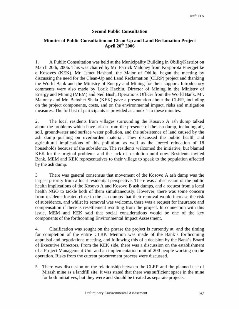
Draft EIA
Preliminary Environmental Assessment 97
Second Public Consultation
Minutes of Public Consultation on Clean-Up and Land Reclamation Project April 20th 2006
1. A Public Consultation was held at the Municipality Building in Obiliq/Kastriot on March 20th, 2006. This was chaired by Mr. Patrick Maloney from Korporota Energjetike e Kosoves (KEK). Mr. Ismet Hashani, the Major of Obiliq, began the meeting by discussing the need for the Clean-Up and Land Reclamation (CLRP) project and thanking the World Bank and the Ministry of Energy and Mining for their support. Introductory comments were also made by Lorik Haxhiu, Director of Mining in the Ministry of Energy and Mining (MEM) and Neil Bush, Operations Officer from the World Bank. Mr. Maloney and Mr. Behxhet Shala (KEK) gave a presentation about the CLRP, including on the project components, costs, and on the environmental impact, risks and mitigation measures. The full list of participants is provided as annex 1 to these minutes. 2. The local residents from villages surrounding the Kosovo A ash dump talked about the problems which have arisen from the presence of the ash dump, including air, soil, groundwater and surface water pollution, and the subsistence of land caused by the ash dump pushing on overburden material. They discussed the public health and agricultural implications of this pollution, as well as the forced relocation of 18 households because of the subsidence. The residents welcomed the initiative, but blamed KEK for the original problems and the lack of a solution until now. Residents invited Bank, MEM and KEK representatives to their village to speak to the population affected by the ash dump. 3 There was general consensus that movement of the Kosovo A ash dump was the largest priority from a local residential perspective. There was a discussion of the public health implications of the Kosovo A and Kosovo B ash dumps, and a request from a local health NGO to tackle both of them simultaneously. However, there was some concern from residents located close to the ash dumps that their removal would increase the risk of subsidence, and whilst its removal was welcome, there was a request for insurance and compensation if there is resettlement resulting from the project. In connection with this issue, MEM and KEK said that social considerations would be one of the key components of the forthcoming Environmental Impact Assessment. 4. Clarification was sought on the phrase the project is currently at, and the timing for completion of the entire CLRP. Mention was made of the Bank’s forthcoming appraisal and negotiations meeting, and following this of a decision by the Bank’s Board of Executive Directors. From the KEK side, there was a discussion on the establishment of a Project Management Unit and an implementation unit of 200 people working on the operation. Risks from the current procurement process were discussed. 5. There was discussion on the relationship between the CLRP and the planned use of
Mirash mine as a landfill site. It was stated that there was sufficient space in the mine for both initiatives, but they were and should be treated as separate projects.

Draft EIA
Preliminary Environmental Assessment 98
6. Technical questions were asked on how the project would ensure international
standards were met in the Mirash mine. 7. List of participants
Ministry for Energy and Mining 20.04.06
Name Institute LORIK HAXHIU MEM
GAZMEND BEGOLLO MEM
BAJRAM HASANI KEK HAMDI GASHI KEK - TC-A
SHYQRI DUMANI INST.i
MJEK.PUNES LUIGJ IMERI KEK - TEB
AGIM PEROLLI Gjenerimi - MQ FLLANZA HOXHA KEK - RRJETI SHEFQET AVDIU KEK-GJENERIM REMZI SHAHINI KEK-GJENERIM AHMET RA A KEK
XHEVDET ELESI Universiteti Prshtinë NASER QORRI INKOS
LULJETA KASTRATI INKOS
YMER VEHAPI INKOS JAHJA GRAJ EVCI DPQ
SHEFQET DOCA DPQ ISMET THAQI DPQ
ADLIJE KRASNIQI DPQ - KEK IDRIZ FETAHU DPQ - KEK
AHMET HOXHA DPQ - KEK ILIR MORINA MMPH
BESIM DOBRAVA MMPH SHAIP AJAZI S.K.KEK
ABDYMEXHID PLLANA DSK. KEK
AGIM BERISHA QYTETAR SAMI
BERBATOVCI KOMUNA NAIM XHIGOLLI QYTETAR
BEHXHET SHALA KEK ISMET HASHANI KRYETAR

Draft EIA
Preliminary Environmental Assessment 99
NEIL BUSH WORLD BANK SABIT RESTELICA MMPH
FEHMI YMERI ING SABRI SIMNICA ING HYSNI MJEKU KK.KASTRIOT
NEZAKETE HAKAJ MMPH LAURA KRYPA MMPH
SHKRI SHABANI MMPH NAIM ALIDEMA MMPH
ESHREF PLLANA Seporinel Kimike
Kek AVNI
KURSHUMLIN D.G.J.- KEK ISTREF KLINAKU DGJ - KEK
SHAQIR DABULLA KOSOVA - SOT ZEQIRJAHJA
HYSENI KEK - DGJ AGIM MORINA KEK - DGJ
HUSH BUBLAKU KEK - DGJ KRESHNIK ELEZI MEM - DM RINOL NISHEVCI MEM - DM
NEZIR SINANI KEK RAME HAMZAJ MMPH SAMI BERISHA KEK TRANDEVINA
CAKAJ KEK GJYLE MORINA RTK - RADIO
SAFETE GRAIQEVCI K.K.KASTRIOT
AGRON HALIMI NSH.AGRONET
HAKI MJEKIQI Drej,i Gjede,Pran
kek SELIM VLLASA ARKATAR,KEKUT
KADRI SHARLAKU Zdruktath tar
Dardhsht ILMI RA I PUNËTOR
ISMET HASHANI DREJTOR i ADRU OSMON GERGURI Q.i DARDHISHTES REXHEP KELANI K.K.KASTRIOT
PALOKE BERISHA KEK - PATRICK
MOLONEY ESBI - KEK

Draft EIA
Preliminary Environmental Assessment 100