PPllaatt TTrraacckkeerr AApppplliiccaanntt … TTrraacckkeerr AApppplliiccaanntt UUsseerr GGuuiiddee...
74
The City of Houston Date Modified: December 16, 2016 Planning and Development Department Rev 1.3 P P l l a a t t T T r r a a c c k k e e r r A A p p p p l l i i c c a a n n t t U U s s e e r r G G u u i i d d e e
Transcript of PPllaatt TTrraacckkeerr AApppplliiccaanntt … TTrraacckkeerr AApppplliiccaanntt UUsseerr GGuuiiddee...

The City of Houston Date Modified: December 16, 2016
Planning and Development Department Rev 1.3
PPllaatt TTrraacckkeerr AApppplliiccaanntt UUsseerr GGuuiiddee
PPllaatt TTrraacckkeerr AApppplliiccaanntt UUsseerr GGuuiiddee
The City of Houston -2- Date Modified: December 16, 2016
Planning and Development Department Rev 1.3
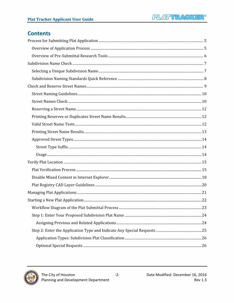
CCoonntteennttss Process for Submitting Plat Application ........................................................................................................................ 5
Overview of Application Process ................................................................................................................................. 5
Overview of Pre-Submittal Research Tools ............................................................................................................. 6
Subdivision Name Check ...................................................................................................................................................... 7
Selecting a Unique Subdivision Name ........................................................................................................................ 7
Subdivision Naming Standards Quick Reference .................................................................................................. 8
Check and Reserve Street Names ...................................................................................................................................... 9
Street Naming Guidelines .............................................................................................................................................. 10
Street Names Check ......................................................................................................................................................... 10
Reserving a Street Name ................................................................................................................................................ 12
Printing Reserves or Duplicates Street Name Results ....................................................................................... 12
Valid Street Name Tests ................................................................................................................................................. 12
Printing Street Name Results ....................................................................................................................................... 13
Approved Street Types ................................................................................................................................................... 14
Street Type Suffix ......................................................................................................................................................... 14
Usage ................................................................................................................................................................................. 14
Verify Plat Location .............................................................................................................................................................. 15
Plat Verification Process ................................................................................................................................................ 15
Disable Mixed Content in Internet Explorer .......................................................................................................... 18
Plat Registry CAD Layer Guidelines .......................................................................................................................... 20
Managing Plat Applications ............................................................................................................................................... 21
Starting a New Plat Application ....................................................................................................................................... 22
Workflow Diagram of the Plat Submittal Process ............................................................................................... 23
Step 1: Enter Your Proposed Subdivision Plat Name ........................................................................................ 24
Assigning Previous and Related Applications .................................................................................................. 24
Step 2: Enter the Application Type and Indicate Any Special Requests .................................................... 25
Application Types: Subdivision Plat Classification ........................................................................................ 26
Optional Special Requests ........................................................................................................................................ 26

PPllaatt TTrraacckkeerr AApppplliiccaanntt UUsseerr GGuuiiddee
The City of Houston -3- Date Modified: December 16, 2016
Planning and Development Department Rev 1.3
Step 3: Identify the Applicant, Subdivider or Developer That is Associated With This Property and
This Plat ................................................................................................................................................................................ 27
Step 4: Propose Street Names ..................................................................................................................................... 28
Adding a Reserved Street to the Plat ................................................................................................................... 28
Adding Streets with No Prior Reservation ........................................................................................................ 29
Updating a Proposed Street Name ........................................................................................................................ 30
Step 5: Upload Applicable Files to Your Application .......................................................................................... 31
Registry CAD File ......................................................................................................................................................... 31
Subdivision Plat File ................................................................................................................................................... 33
Upload Required Documents .................................................................................................................................. 33
Upload Additional Documents ................................................................................................................................ 36
Step 6: Upload CAD Drawing and Verify Its Geographic Location ............................................................... 37
Visual Inspection Process ......................................................................................................................................... 38
Step 7: Enter Plat Data .................................................................................................................................................... 40
Checkbox ......................................................................................................................................................................... 41
Dropdown ....................................................................................................................................................................... 41
Step 8: Draft Platting Fees Calculations ................................................................................................................... 41
Step 9: Plat Application Summary ............................................................................................................................. 42
Step 10: Affidavit of the Owner ................................................................................................................................... 44
Affidavit ............................................................................................................................................................................ 44
Payments .............................................................................................................................................................................. 45
Payment History ............................................................................................................................................................... 46
Pay Balance & Email Balance .................................................................................................................................. 46
Pay Outstanding Balance & Credits ...................................................................................................................... 48
Managing Draft Applications ............................................................................................................................................ 51
Updating a Draft Application ....................................................................................................................................... 51
Deleting a Draft Application ......................................................................................................................................... 51
Reviewing Submitted Plat Applications ....................................................................................................................... 52
Search Submitted Applications ........................................................................................................................................ 52
Search Criteria Lists/Plat Status ................................................................................................................................ 54

PPllaatt TTrraacckkeerr AApppplliiccaanntt UUsseerr GGuuiiddee
The City of Houston -4- Date Modified: December 16, 2016
Planning and Development Department Rev 1.3
Select a Type .................................................................................................................................................................. 54
Viewing the Applications ............................................................................................................................................... 56
Subdivision Page .......................................................................................................................................................... 56
Plat Data Page ................................................................................................................................................................ 57
Location and Contact Page ............................................................................................................................................ 58
Location Data ................................................................................................................................................................. 59
Fees ......................................................................................................................................................................................... 61
Document ............................................................................................................................................................................. 62
Find a Subdivision Application Number ...................................................................................................................... 63
Subdivision Name Change.................................................................................................................................................. 64
Extension of Approval ......................................................................................................................................................... 66
Recordation .............................................................................................................................................................................. 68
Plat Application Approval Timeline ............................................................................................................................... 74

PPllaatt TTrraacckkeerr AApppplliiccaanntt UUsseerr GGuuiiddee
The City of Houston -5- Date Modified: December 16, 2016
Planning and Development Department Rev 1.3
PPrroocceessss ffoorr SSuubbmmiittttiinngg PPllaatt AApppplliiccaattiioonn
OOvveerrvviieeww ooff AApppplliiccaattiioonn PPrroocceessss
Any organization wishing to begin a land development project must first complete (and submit) a
plat application via the Plat Tracker. The application is delivered electronically to the city's
Department of Planning and Development for review, and it is ultimately forwarded to the Planning
Commission for approval.
The diagram on the right displays a
high level overview of the plat
submittal process. Each flow
symbol represents a grouping of
steps. These are detailed in the
sections to follow.
The boxes labeled "Pre-Submittal
Research" are performed outside
of the plat application process.
Although these are optional, if
performed in advance of the plat
application, they can save the user
time in creating and/or reworking
their application. For instance, the
subdivision name check tool helps
you determine a unique name for
your subdivision. Similary, the
street name check tool verifys that
your street name is unique. In
addition, it allows you to reserve
street names for your organization.
Note: a street name check is only
necessary:
a) If your appliation proposes new streets, and
b) If your organization did not previously reserve street names to be used with this application.

PPllaatt TTrraacckkeerr AApppplliiccaanntt UUsseerr GGuuiiddee
The City of Houston -6- Date Modified: December 16, 2016
Planning and Development Department Rev 1.3
Moreover, it is recommeded to verify the plat’s boundary location using the CAD registry drawing.
This is useful for obtaining a preliminary determination of the drawing’s geographical correctness.
Correcting any "slightly off" boundary conditions early on will help prevent delays in the
application process. (see Verify Plat Location)
Once the pre-submittal research steps are complete, prepare your plat application (nine steps plus
a summary). At the end of the process, you may save a draft copy or submit the final copy for review
by the Planning Commisssion.
OOvveerrvviieeww ooff PPrree--SSuubbmmiittttaall RReesseeaarrcchh TToooollss
The following diagram shows the steps involved in the pre-application processes.

PPllaatt TTrraacckkeerr AApppplliiccaanntt UUsseerr GGuuiiddee
The City of Houston -7- Date Modified: December 16, 2016
Planning and Development Department Rev 1.3
SSuubbddiivviissiioonn NNaammee CChheecckk The Plat Tracker subdivision name check tool helps you find a unique subdivision name for your
project. This tool is available to all Plat Tracker users as well as the general public. For access prior
to login, open the Plat Tracker portal page, and click the link: 'Plat Tracker Public
Links/Subdivision Name Check'. If you have already logged into Plat Tracker, find the tool using
menu option: 'Plat Submittal/Check Subdivision Name'. Both methods open the 'Subdivision
Names Check' page where you may validate subdivision name(s) for duplication and uniqueness
against the Plat Tracker database. For subdivision naming guides, refer to the 'Subdivision Naming
Standards Quick Reference 'section below. In addition, you will find a link on the 'Subdivision
Names Check' page, 'Subdivision Naming Guide' (see "A"). This provides examples of subdivision
names and their associated naming rules.
SSeelleeccttiinngg aa UUnniiqquuee SSuubbddiivviissiioonn NNaammee
To verify uniqueness, type the proposed name or any part of the name into the 'Subdivision Base
Name' box. Click the 'Check Proposed Subdivision Name' button to display the results Similar
or Duplicate Subdivision Names list. Note that the listing may be associated with a previous
application for this property. In that case, the name is not considered a duplicate in Plat Tracker.
This is handled during the application process.
Export to PDF (below):
To download the Similar or Duplicate Subdivision Names list, click the 'Export to PDF' button
(see "C"). A dialog box asked to 'Open' or 'Save' the document. To 'Save', choose a preferred
location to save on your computer. The subdivision checked list will be created in Adobe PDF
document.

PPllaatt TTrraacckkeerr AApppplliiccaanntt UUsseerr GGuuiiddee
The City of Houston -8- Date Modified: December 16, 2016
Planning and Development Department Rev 1.3
Link to 'Subdivision Naming Guide' document including examples (in PDF format).
Enter partial or entire subdivision base name.
Save and/or print the Similar or Duplicate Subdivision Names list in PDF format. Click the 'Export To PDF' button.
Listing of potentially duplicate subdivision names along with the plat application number and submittal date.
SSuubbddiivviissiioonn NNaammiinngg SSttaannddaarrddss QQuuiicckk RReeffeerreennccee
Name must be unique unless the subdivision is part of a previous application in Plat Tracker. Below
is a list of subdivision naming standards. A complete list with examples is available the webpage as
shown in button "A" above.
1. Meet current Chapter 42 standard.
2. No punctuation or symbols (i.e. no commas, no periods, no &, no @, no -).
3. No articles at the beginning of plat names (i.e. "A" and "The").
PPllaatt TTrraacckkeerr AApppplliiccaanntt UUsseerr GGuuiiddee
The City of Houston -9- Date Modified: December 16, 2016
Planning and Development Department Rev 1.3
4. No full names of a person (e.g. Robert Jones Subdivision).
5. No numbers at beginning of name.
6. No street addresses in the subdivision name.
7. No street intersections as subdivision name (i.e. Southeast corner of Smith Dr and Johnson
Street).
8. No lot and block as subdivision name.
9. Word abbreviations must be spelled out unless commonly known.
10. Street Dedication Plat format: Name of Street + limits of street dedication (from/to) + STD
(e.g. Willow Street from Market Street to Hardy Drive STD).
11. School format: District Name + Name of School (e.g. HISD Harvard Elementary School, Fort
Bend ISD, or Flamord Elementary School).
12. MUD format: County Name/Development Name + District Name + Service (i.e. Harris
County MUD no 10 Water Plant no 4).
13. Replat format: partial replats of single family subdivisions with separately filed deed
restrictions must be sequentially numbered referring back to the original plat name.
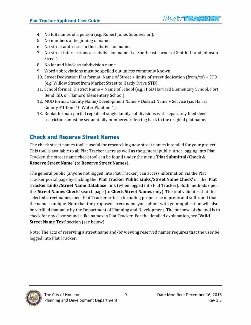
CChheecckk aanndd RReesseerrvvee SSttrreeeett NNaammeess The check street names tool is useful for researching new street names intended for your project.
This tool is available to all Plat Tracker users as well as the general public. After logging into Plat
Tracker, the street name check tool can be found under the menu 'Plat Submittal/Check &
Reserve Street Name' (to Reserve Street Names).
The general public (anyone not logged into Plat Tracker) can access information via the Plat
Tracker portal page by clicking the 'Plat Tracker Public Links/Street Name Check' or the 'Plat
Tracker Links/Street Name Database' link (when logged into Plat Tracker). Both methods open
the 'Street Names Check' search page (to Check Street Names only). The tool validates that the
selected street names meet Plat Tracker criteria including proper use of prefix and suffix and that
the name is unique. Note that the proposed street name you submit with your application will also
be verified manually by the Department of Planning and Development. The purpose of the tool is to
check for any close sound-alike names in Plat Tracker. For the detailed explanation, see 'Valid
Street Name Test' section (see below).
Note: The acts of reserving a street name and/or viewing reserved names requires that the user be
logged into Plat Tracker.

PPllaatt TTrraacckkeerr AApppplliiccaanntt UUsseerr GGuuiiddee
The City of Houston -10- Date Modified: December 16, 2016
Planning and Development Department Rev 1.3
SSttrreeeett NNaammiinngg GGuuiiddeelliinneess
The Plat Tracker street naming guidelines include a summary of street naming conventions as well
as a basic street naming example. For street naming guides, refer to 'Street Names Check' section
below. In addition, you will find a link on the 'Street Names Check' page, 'Street Naming
Guidelines'. This provides examples of street names and their associated naming rules.
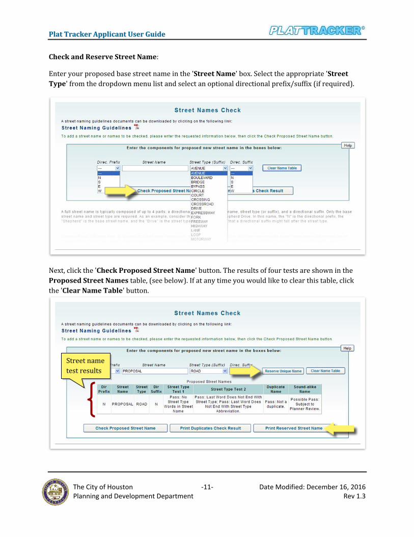
SSttrreeeett NNaammeess CChheecckk
A street name is composed of the four parts: directional prefix, base street name, street type suffix,
and directional suffix. A street name MUST include the base street name and street name suffix.
Both the directional prefix and suffix are optional.
Directional prefix – N, S, E, W
Base street name – Main is the base street name in N Main Street
Street type suffix – Street, Lane, Avenue, etc. A complete list of suffixes and usage rules can
be found on at the end of this section as well as on the 'Street Name Check' webpage.
Reference Sec. 42-133 (4)
Directional suffix - N, S, E, W
PPllaatt TTrraacckkeerr AApppplliiccaanntt UUsseerr GGuuiiddee
The City of Houston -11- Date Modified: December 16, 2016
Planning and Development Department Rev 1.3
Check and Reserve Street Name:
Enter your proposed base street name in the 'Street Name' box. Select the appropriate 'Street
Type' from the dropdown menu list and select an optional directional prefix/suffix (if required).
Next, click the 'Check Proposed Street Name' button. The results of four tests are shown in the
Proposed Street Names table, (see below). If at any time you would like to clear this table, click
the 'Clear Name Table' button.
Street name
test results

PPllaatt TTrraacckkeerr AApppplliiccaanntt UUsseerr GGuuiiddee
The City of Houston -12- Date Modified: December 16, 2016
Planning and Development Department Rev 1.3
RReesseerrvviinngg aa SSttrreeeett NNaammee
If the street name passes the validity tests, you may reserve that street name for the organization.
Click the 'Reserve Unique Name' button, and the street name will be saved for your organization.
The street name will be available to use by any user in your organization and on a single plat
application. This reservation is valid for 60 days.
PPrriinnttiinngg RReesseerrvveess oorr DDuupplliiccaatteess SSttrreeeett NNaammee RReessuullttss
Export to PDF:
To download the Reserved Street Names / Duplicates Check Result list, click the 'Print
Reversed Street Name' or 'Print Duplicates Check Result' button respectively. A dialog box will
ask to 'Open' or 'Save' the document. To 'Save', choose a preferred location to save on your
computer. The street check list will be created in an Adobe PDF document.
VVaalliidd SSttrreeeett NNaammee TTeessttss
A valid name must pass the following tests. If the first three tests result in a "PASS", then the street
name must receive final approval from the planner. If any one of the four tests "FAIL", the street
name cannot be used.
1. Street Type Test 1 - The first word in the base name is not a directional prefix.
2. Street Type Test 2 - The last word in the base name is not a directional suffix.
3. Duplicate Name Test - In order to facilitate the best possible emergency response, no new
street name can duplicate an existing street name that is already found in city address point
or roads data. In addition, it cannot match a street that has been reserved by another plat
applicant.
4. Sound -Alike Name Test – Final determination of usage will be made by the Planning
Department.
Check Street Name ONLY:
The tool can be access via the Plat Tracker portal page by clicking the 'Plat Tracker Public
Links/Street Name Check' or the 'Plat Tracker Links/Street Name Database' link (when logged
into Plat Tracker).
Enter your proposed base street name in the 'Street Name' box. Select the appropriate 'Street
Type' from the dropdown menu list and select an optional directional prefix/suffix (if required).
Next, click the 'Add Street Name' button (see below).
Note: You must click the 'Add Street Name' button first to add to the table below before clicking
the 'Check Proposed Street Name' button. This allows you to build a list of streets and results for
exporting to a PDF.

PPllaatt TTrraacckkeerr AApppplliiccaanntt UUsseerr GGuuiiddee
The City of Houston -13- Date Modified: December 16, 2016
Planning and Development Department Rev 1.3
Then, click the 'Check Proposed Street Name' button (see below). The results of four tests are
shown in the 'Proposed Street Names' table (see below). If at any time you would like to clear this
table, click the 'Clear Name Table' button.
PPrriinnttiinngg SSttrreeeett NNaammee RReessuullttss
Export to PDF (above):
To download the Proposed Street Names list, click the 'Export to PDF' button. A dialog box will
ask to 'Open' or 'Save' the document. To 'Save', choose a preferred location to save on your
computer. The street checked list will be created in an Adobe PDF document.
Street name
test results

PPllaatt TTrraacckkeerr AApppplliiccaanntt UUsseerr GGuuiiddee
The City of Houston -14- Date Modified: December 16, 2016
Planning and Development Department Rev 1.3
AApppprroovveedd SSttrreeeett TTyyppeess
SSttrreeeett TTyyppee SSuuffffiixx UUssaaggee Circle Court
Loop
Streets that terminate at a cul-de-sac or are configured as a loop street
Boulevard Crossing Crossroad Motorway
Parkway Speedway Throughway
Major thoroughfares, major collector streets, collector streets or other streets designed to handle traffic volumes in excess of normal neighborhood traffic generation or that are divided streets with at least two lanes of traffic in each direction separated by a median
Bypass Expressway
Freeway Highway
Highways or freeways subject to the jurisdiction of the state department of transportation
Avenue Drive
Road Street
Major thoroughfares, major collector streets, collector streets or local streets
Bridge Fork Lane Oval Passage
Path Place Trail Way
Collector streets or local streets
Tunnel Streets that provide underground or underwater passage

PPllaatt TTrraacckkeerr AApppplliiccaanntt UUsseerr GGuuiiddee
The City of Houston -15- Date Modified: December 16, 2016
Planning and Development Department Rev 1.3
VVeerriiffyy PPllaatt LLooccaattiioonn This step offers applicants a way to verify the geographic correctness of their CAD drawing outside
of the plat application process. The review process is performed visually in which you will verify
the polygon boundary of your CAD registry file. Correcting any errors prior to submitting your
application will reduce delays in the review process.
Select the menu option 'Plat Submittal/Verify Plat Location' which opens the 'Verify Plat
Location' webpage.
PPllaatt VVeerriiffiiccaattiioonn PPrroocceessss
Use the interface shown below to upload your Registry Template CAD drawing into Plat Tracker.
Note that your CAD drawing must adhere to the Plat Tracker registry layering requirements. For
your convenience, links to both the requirements and an example Registry CAD template are
provided on the Plat Tracker home page under 'Plat Tracker Public Links'. In Section "A" below,
browse to your file using the 'Browse' button. Then select the county for your plat and the scale
factor of the CAD drawing (allowable values are 0.9 to 1.1). Finally, click the 'Upload and View Plat
Map' button.
IMPORTANT: To view a plat map, you MUST enable Pop-Ups in your browser.
Also, you will see this Security Warning in IE, click 'No' when asked about delivering non-https content.

PPllaatt TTrraacckkeerr AApppplliiccaanntt UUsseerr GGuuiiddee
The City of Houston -16- Date Modified: December 16, 2016
Planning and Development Department Rev 1.3
Upload Registry plat AutoCAD file ('Browse' button), 'Select a County', and enter the drawing’s combined scale factor (limited to a scale factor of 0.9 to 1.1; Ex: 0.99993971752).
First, the entire map for the Houston extraterritorial jurisdiction (ETJ) region will display. Your
CAD drawing is NOT visible at this point. Click the button 'Verify Plat Location Now' to continue.
Next, your CAD file is processed by the Plat Tracker GIS system. If this runs smoothly, a message
will display indicating success. The GIS system interprets the geographic location of your CAD
drawing and fills the screen with a map of the location. In addition, the CAD drawing is presented as
a transparent yellow overlay.
Review this map to ensure that your plat boundary is in the correct geographic location. Zoom out
using the Zoom tool on the left. Any boundary that is "slightly off" should be corrected. If you
continue to have problems with alignment or want to discuss "slightly off" plat locations, contact
Planning Department staff.
When you finish viewing the location map, click the button 'Go Back' to return you to the 'Verify
Plat Location' page.

PPllaatt TTrraacckkeerr AApppplliiccaanntt UUsseerr GGuuiiddee
The City of Houston -17- Date Modified: December 16, 2016
Planning and Development Department Rev 1.3
If your registry CAD file fails visual inspection, you should save your work, correct your file, and reload
the registry. Prior to submitting your plat application, you may make corrections and verify your CAD
drawing as many times as you like.
Move slider to zoom out
to see details

PPllaatt TTrraacckkeerr AApppplliiccaanntt UUsseerr GGuuiiddee
The City of Houston -18- Date Modified: December 16, 2016
Planning and Development Department Rev 1.3
DDiissaabbllee MMiixxeedd CCoonntteenntt iinn IInntteerrnneett EExxpplloorreerr
Plat Tracker is a secure site. Since there are many components during the submittal of the plat
applications, IE won’t remember your choice and the warning message and will appear every time
you visit that page or web site. It basically means that the secure (https) web page that you are
trying to open contains images or other elements, in this case the Registry Template AutoCAD
drawings that are hosted on a non-https location. They call it mixed content.
Here are the steps to get rid of the Security Warning dialog box while using Internet Explorer 8 by
changing the setting. This will remove all security warnings while using the browser in the future.
However, you can reverse the process by going back and select the "Prompt" radio button later on.
Go to the Internet Explorer
browser menu bar; select the
'Tools' tab and then the 'Internet
Options'.
Internet Explorer > Tools >
Internet Options > See "A".
Next select the 'Security' tab in
the Internet Option box.
Make sure the 'Internet' zone is
selected and then click the
'Custom Level' button.
Scroll-down the list of options
and under the Miscellaneous
group, 'Display mixed content'
select the radio button to set from
"Prompt" to "Enable."
Click OK when done. To reverse
the step in the future, remember
to select the "Prompt" radio
button.

PPllaatt TTrraacckkeerr AApppplliiccaanntt UUsseerr GGuuiiddee
The City of Houston -19- Date Modified: December 16, 2016
Planning and Development Department Rev 1.3
Scroll-down the list of
options and under the
Miscellaneous group,
check 'Display mixed
content' to "Enable."

PPllaatt TTrraacckkeerr AApppplliiccaanntt UUsseerr GGuuiiddee
The City of Houston -20- Date Modified: December 16, 2016
Planning and Development Department Rev 1.3
PPllaatt RReeggiissttrryy CCAADD LLaayyeerr GGuuiiddeelliinneess
The CAD file (registry drawing) should include the layers shown below. Please include the CAD
layer names in the order as displayed.
No. CAD Layer Name Description
0 0 This layer is primarily used for block layers, inserting blocks or objects, and xrefs. This layer will not be used for plat content and cannot be deleted.
1 VERSION 0.1 When there are updates to the Planning Department's CADD template a new version number will be assigned and applicants will be instructed to use the newest template for preparing registry drawings.
2 G-PLAT-BNDY This layer is assigned to polygons that define the boundary of the proposed plat so that they can be put into COHGIS. (City of Houston GIS)
3 G-PLAT-BNDY-ANNO This layer is assigned to text that identifies the boundary of the proposed plat so that they can be put into COHGIS.
4 G-PLAT-COOR This layer Identifies the State Plane Coordinate points relative to the plat boundary.
5 G-PLAT-PROP This layer is assigned to lines that represent property lot, reserve and fee strip lines within the proposed plat boundary so that they can be put into COHGIS.
6 G-PLAT-PROP-ANNO This layer is assigned to text that shows all block numbers, each individual lot number and fee strip record information within the plat boundary. Also, identifies text for reserves by alphabetical letter, land use restriction and acreage/sf of reserve within the plat boundary.
7 G-PLAT-ROW This layer is assigned to polygons that represent the boundaries of public street, alley, Type 1 PAE, and Type 2 PAE rights-of-way within the proposed plat boundary so that they can be put into COHGIS.
8 G-PLAT-STNM-ANNO This layer is assigned to text that represents the proposed street names to be used for public streets, Type 1 PAE, and Type 2 PAE within the proposed plat boundary so that they can be put into COHGIS.
9 G-PLAT-ESMT The layer that is assigned to lines that represent shared driveway easements, multifamily private streets, and one-foot reserves within the proposed plat boundary so that they can be put into COHGIS. This layer excludes electric/communication easements.

PPllaatt TTrraacckkeerr AApppplliiccaanntt UUsseerr GGuuiiddee
The City of Houston -21- Date Modified: December 16, 2016
Planning and Development Department Rev 1.3
10 G-PLAT-ESMT-ANNO The layer that is assigned to text that represent shared driveway easements, multifamily private streets, and one-foot reserves within the proposed plat boundary so that they can be put into COHGIS. This layer excludes electric/communication easements.
11 G-PLAT-NAME-ANNO This layer is assigned to text that identifies the subdivision plat name within the proposed plat boundary so that it can be put into COHGIS. The subdivision name will be spread diagonally across the plat boundary.
12 G-PLAT-ADDR-PTS The layer is assigned to symbols that identify the street that the property will be addressed. For each property being addressed place a circular button symbol at the property line and street ROW. Identifying the specific street to be addressed from where corner lots are platted or where the plat has access to two or more streets.
MMaannaaggiinngg PPllaatt AApppplliiccaattiioonnss Plat applications are accessed via the menu option 'Plat Submittal/My Plat Applications'. Here
you may begin a new plat application, submit new or draft plat applications, and/or review
previously submitted plats.
First, you will be prompted to select one of
three options including: 'Start New Plat
Application', manage an existing draft
application ('Go to Draft Application'), or
review a previously submitted application
('Go to All Applications'). The section
below details starting a new application.
Information regarding managing draft and
previously submitted applications can be

PPllaatt TTrraacckkeerr AApppplliiccaanntt UUsseerr GGuuiiddee
The City of Houston -22- Date Modified: December 16, 2016
Planning and Development Department Rev 1.3
found in the Managing Draft Applications and Reviewing Submitted Plat Applications sections
respectively.
SSttaarrttiinngg aa NNeeww PPllaatt AApppplliiccaattiioonn The Plat Tracker plat submittal process is
composed of nine steps. The first seven
steps allow the organization’s users to
enter all the details relating to their plat
projects. Step eight and nine are an
estimation of fees and a summary of your
work, respectively. The last step completes
the process by formally submitting the
application with an affidavit. Start by
selecting the option, 'Start New Plat
Application'. This automatically opens the first page you will use to start a new plat application.

PPllaatt TTrraacckkeerr AApppplliiccaanntt UUsseerr GGuuiiddee
The City of Houston -23- Date Modified: December 16, 2016
Planning and Development Department Rev 1.3
WWoorrkkffllooww DDiiaaggrraamm ooff tthhee PPllaatt SSuubbmmiittttaall PPrroocceessss

PPllaatt TTrraacckkeerr AApppplliiccaanntt UUsseerr GGuuiiddee
The City of Houston -24- Date Modified: December 16, 2016
Planning and Development Department Rev 1.3
SStteepp 11:: EEnntteerr YYoouurr PPrrooppoosseedd SSuubbddiivviissiioonn PPllaatt NNaammee
The first screen is used to perform a preliminary validation of your proposed subdivision name.
The tool validates the subdivision name against other subdivisions currently in use. Recall that the
validation function may also be performed outside of the plat application process. (See
Subdivision Name Check section).
Simply enter the proposed name into the 'Subdivision Base Name' box along with the appropriate
section number, suffix, and project name (if applicable). Then click the 'Check Subdivision Name'
button. If you need help, click the link provided to the "Help: Subdivision Naming Guidelines".
You can read more on this topic in the Subdivision Naming Standards Quick Reference section in
this document.
If the subdivision name is not duplicated in the Plat Tracker database, then a PASS message will
display as shown above. Note: duplicate subdivision names are only allowed if the project has a
previous application using the same name.
AAssssiiggnniinngg PPrreevviioouuss aanndd RReellaatteedd AApppplliiccaattiioonnss You may attach multiple related applications to your plat as well as a single previous application.
Use the "Tool: Search for Previous or Related Application" in the middle of the page. (See Step 1
Screenshot on the next page). Enter a portion of the previous/related subdivision name into the
'Subdivision Name' box. Then click the 'Search by Name' button. Select a related subdivision by
clicking the appropriate 'Related App' radio button. You may undo your work by clicking the '
Reset' radio button. Note that you may assign as many related applications as you require.
However, only one previous application may be assigned. If you have multiple previous
applications, it is recommended that you select the most recent one. Click the appropriate '
Previous App' radio button. This results in its application number displaying in the 'Previous Plat
Application' box (see top of web page). You may change 'Previous Plat Application' number
manually or by selecting a replacement 'Previous App'. Note that a table of all attached previous
Enter the proposed subdivision
base name. If the subdivision name
is not duplicated, then a PASS
message will display as shown here.
However, it is still subject to further
review by planner.

PPllaatt TTrraacckkeerr AApppplliiccaanntt UUsseerr GGuuiiddee
The City of Houston -25- Date Modified: December 16, 2016
Planning and Development Department Rev 1.3
and related plats appears at the bottom of the page. There you may use the "Remove" link to
remove any unwanted applications.
Note: You may navigate forward and backwards between steps by clicking 'Save and Continue' or '
Previous' buttons available at the bottom of the screen.
SStteepp 22:: EEnntteerr tthhee AApppplliiccaattiioonn TTyyppee aanndd IInnddiiccaattee AAnnyy SSppeecciiaall RReeqquueessttss
To proceed, 'Select Application Type' from the dropdown list provided. Also, click the checkbox of
any valid special requests that apply to your project. A list of available application types follows
along with special request(s) selections for each type. Refer to the Chapter 42 ordinance for a
complete definition of each application type. Enter Original Subdivision Name if applicable.
Select from valid
special request(s)
Enter subdivision
partial or full name
Select any previous
or related plats
List of attached previous
or related apps

PPllaatt TTrraacckkeerr AApppplliiccaanntt UUsseerr GGuuiiddee
The City of Houston -26- Date Modified: December 16, 2016
Planning and Development Department Rev 1.3
AApppplliiccaattiioonn TTyyppeess:: SSuubbddiivviissiioonn PPllaatt CCllaassssiiffiiccaattiioonn OOppttiioonnaall SSppeecciiaall RReeqquueessttss Class 1 Subdivision Plat (C1)
Reconsideration of Requirement
Class 2 Subdivision Plat (C2) Variance Special Exception Reconsideration of Requirement
Class 2 Subdivision Replat (C2R)
Variance Special Exception Reconsideration of Requirement
Class 3 Subdivision Final Plat (C3F)
Reconsideration of Requirement
Class 3 Subdivision Replat Public Hearing Notification (C3N)
Variance Special Exception Reconsideration of Requirement
Class 3 Subdivision Preliminary Plat (C3P)
Variance Special Exception Reconsideration of Requirement
Class 3 Subdivision Preliminary Replat (C3R)
Variance Special Exception Reconsideration of Requirement
General Plan (GP)
Variance Special Exception Reconsideration of Requirement
Street Dedication Plat (SP)
Variance Special Exception Reconsideration of Requirement
Vacating Preliminary (VP)
Vacating Final (VF)

PPllaatt TTrraacckkeerr AApppplliiccaanntt UUsseerr GGuuiiddee
The City of Houston -27- Date Modified: December 16, 2016
Planning and Development Department Rev 1.3
SStteepp 33:: IIddeennttiiffyy tthhee AApppplliiccaanntt,, SSuubbddiivviiddeerr oorr DDeevveellooppeerr TThhaatt iiss AAssssoocciiaatteedd WWiitthh TThhiiss PPrrooppeerrttyy
aanndd TThhiiss PPllaatt
This screen displays the applicant (your organization) and the project manager (the organization’s
principal contact). In addition, a developer may be selected from the table listing in the center of the
page. The list includes developers previously used by your organization. Click the 'Select' link. Note
that only one developer can be selected per application.
If your developer does not appear
in the list, you may simply add a
new developer by entering their
company details in the boxes
provided. Notice that all fields are
required. Next, click the 'New
Developer' checkbox, and click
the button 'Save New Developer'. This will immediately attach the new developer to your
application. Since only one developer is allowed per application, adding a new developer after
Project Developer
Organization and
Principal Contact

PPllaatt TTrraacckkeerr AApppplliiccaanntt UUsseerr GGuuiiddee
The City of Houston -28- Date Modified: December 16, 2016
Planning and Development Department Rev 1.3
selecting one previously will result in your new entry replacing the one currently listed for this
project. When the record is saved, a message displays stating that the developer was saved to the
database.
SStteepp 44:: PPrrooppoossee SSttrreeeett NNaammeess
This page serves several purposes. It gives you the ability to propose already reserved street names
to your plat application, as well as add non-reserved proposed street names. A listing will display
including all streets saved for your organization, regardless if they were reserved or proposed. (To
understand "proposed" streets, see the Adding Streets Without a Prior Reservation section below.)
AAddddiinngg aa RReesseerrvveedd SSttrreeeett ttoo tthhee PPllaatt To add a reserved street to your application, simply locate the street name in the table listing.
Notice the "Category" dropdown list. The available categories are:
Public (default)
Type 1 PAE
Type 2 PAE
You may change the category shown by selecting a new category from the dropdown list. Then click
the 'Add To Table' button. This will update the category and assign the street to your plat
application. At the same time, it’s Reserved "Status" becomes "Proposed". Thus the street is saved
for your current project / application.

PPllaatt TTrraacckkeerr AApppplliiccaanntt UUsseerr GGuuiiddee
The City of Houston -29- Date Modified: December 16, 2016
Planning and Development Department Rev 1.3
Note: you may also remove a street from the application by clicking its associated 'Remove' button.
AAddddiinngg SSttrreeeettss wwiitthh NNoo PPrriioorr RReesseerrvvaattiioonn You have the ability to add a new street name directly to the plat application. First, enter the street
name into the boxes provided ('New Street Names'). Recall that the 'Street Name' (base name)
and 'Street Type' (dropdown list) are required. The directional prefix and suffix are optional.

PPllaatt TTrraacckkeerr AApppplliiccaanntt UUsseerr GGuuiiddee
The City of Houston -30- Date Modified: December 16, 2016
Planning and Development Department Rev 1.3
Refer to the Street Naming Guidelines section for more information. To add the proposed street,
click the 'Add To Table' button. The new street name will appear in the table.
UUppddaattiinngg aa PPrrooppoosseedd SSttrreeeett NNaammee
Enter proposed street name, and click the 'Add To Table' button.
The New Street Name has been saved. If you enter a street name that was previously reserved or is a duplicate, then an error message will display. (see above)
Updating a Proposed Street Name: You can update the category shown by selecting a new category from the dropdown list: Public, Type 1 PAE or Type 2 PAE. Click the 'Add' button will change its Reserved "Status" to become "Proposed". Thus the street is saved and proposed for your current project / application. The list of Proposed street name(s) will appear in Step 9 in the Plat Application Summary.
You may modify a proposed street name listed on your application. First remove the street name from the table list by clicking the 'Remove' button. It will prompt a dialog message, "Are you sure you want to remove it?" Click, 'OK' and the proposed street name will be removed (see previous page). To add another proposed street, enter a name into the 'New Street Names' fields, and click the 'Add to Table' button.

PPllaatt TTrraacckkeerr AApppplliiccaanntt UUsseerr GGuuiiddee
The City of Houston -31- Date Modified: December 16, 2016
Planning and Development Department Rev 1.3
SStteepp 55:: UUppllooaadd AApppplliiccaabbllee FFiilleess ttoo YYoouurr AApppplliiccaattiioonn
At this point, you will upload all the external files associated with your project. Two CAD files are
required. The first is the registry CAD drawing based on the registry template / layers. Once
uploaded, you verify that your drawing depicts the appropriate geographic boundary location. The
second CAD file is the subdivision plat which includes all your layers, such as sections, lots, etc.
RReeggiissttrryy CCAADD FFiillee Begin by uploading your registry CAD drawing. You should have verified this file previously (refer
to the Verify Plat Location section of this document). If your plat was not previously verified, you
will be able to perform this process in the next step.
Your registry CAD file must be created in accordance with the registry template guidelines (see the
Plat Registry CAD Layer Guidelines section for more information). To load your completed file,
select the 'AutoCAD Files/Registry' option shown in the screenshot that follows. Choose the
'Projection' (county) associated with the project. Counties currently in Plat Tracker are: Harris,
Fort Bend, Waller, Montgomery, and Liberty. Enter the appropriate 'Scale Factor' for your drawing.
Note, the scale factor range is limited to 0.9-1.1. For numbers less than 1, enter a zero prior to the
decimal point (example: 0.99 is correct and .99 is incorrect). Entering values without the leading
zero (as required) or values outside the allowable range will result in an error. Next, click the
'Browse…' button to search for your CAD drawing. Once you select a file, click the 'Save AutoCAD
File' button. This will save your file to the Plat Tracker database. At that point, a message will
display "The Registry File has been successfully uploaded."
Registry CAD
information Select and save the files

PPllaatt TTrraacckkeerr AApppplliiccaanntt UUsseerr GGuuiiddee
The City of Houston -32- Date Modified: December 16, 2016
Planning and Development Department Rev 1.3
Note: If you previously saved a file (example Registry CAD file), saving a new file will replace the
one previously assigned to the application.
The "Uploaded Files" list at the bottom of the page displays a table listing of all files uploaded for
this application. Plat Tracker adds a prefix to the filename indicating the contents. For example, the
registry CAD drawing was uploaded as Sample-CAD001.DWG. Plat Tracker renamed it to: Registry_
Sample-CAD001.DWG. (see screenshot that follows)
Upload registry and subdivision plat CAD files and .PDF of the subdivision plat.
Upload additional files as required along with links to the associated ordinance.

PPllaatt TTrraacckkeerr AApppplliiccaanntt UUsseerr GGuuiiddee
The City of Houston -33- Date Modified: December 16, 2016
Planning and Development Department Rev 1.3
Click the "Open Forms" link open a new page to fill in the 'Variance Form', 'Special Exception Form', 'Reconsideration of Requirement Form' and 'Public Hearing Form' for 'Special Requests', if applicable.
List of all files associate with this application. Files can be removed by clicking "Remove" link for that file. Saving a new file will replace the one previously assigned to the application.
SSuubbddiivviissiioonn PPllaatt FFiillee The subdivision plat drawing file must be attached to your application. This includes the complete
CAD drawing along with a .PDF image of the drawing. The subdivision plat contains the details of
the project and including sections, blocks, lots, etc. To upload the CAD file, simply go to the
'AutoCAD Subdivision Plat File' option, click 'Browse…' to search for your file. When the file is
selected, click the 'Save AutoCAD Subdivision File' button. (This process is identical to the
'AutoCAD Registry File' procedure). Once the file is uploaded, a message will display: "The
Subdivision Plat File has been successfully uploaded.", and the new file will display in the
Uploaded Files list at the bottom of the screen. At this point, you should upload the PDF version of
the drawing. 'Browse…', for the file, and click 'Save Plat PDF' to complete the save process.
UUppllooaadd RReeqquuiirreedd DDooccuummeennttss There are several required document types that must be attached to your application, depending
upon the Application Type you select. (For uploading additional documents type, simply click
'Attach' besides the Label for each appropriate descriptions, 'Browse' for the document to upload
from your computer. See "Upload Additional Documents" below.)
For Special Request Forms of Variance, Special Exception, Reconsideration of Requirement or
Public Hearing options, first scroll down the page to the 'Special Request Forms' section to
"Open Forms" link. Select from the radio-button menu one of the Variance, Special Exception,
Reconsideration of Requirement or Public Hearing options.

PPllaatt TTrraacckkeerr AApppplliiccaanntt UUsseerr GGuuiiddee
The City of Houston -34- Date Modified: December 16, 2016
Planning and Development Department Rev 1.3
To learn more about "Application Types" & "Optional Special Requests" documents that are
required, see the chapter Starting a New Plat Application, Step 2: Enter the Application Type
and Indicate Any Special Requests in the earlier part of this Plat Tracker Applicant User Guide
document (above).
Example: Select the radio-button 'New Variance Form' for Variance document. Select the other
Special Request Documents, if applicable.
Note: 'Reconsideration of Requirement Form' and 'Public Hearing Form' - only ONE document
is allowed each. 'Variance Form' and 'Special Exception Form' can consist of multiple forms.
IMPORTANT: Variance or Special Exception Requests are limited to C1, C2, C2R, GP, C3P, C3R, C3N, and
SP Plat Types.
Scroll down the page to the
'Special Request Forms'
section to fill in the
appropriate forms.
First click on the label, "Open Forms" to view
another page. There it will display the different
type of 'Special Request' documents available.
Select the type of 'Special
Request' documents from the
radiogroup list of options.

PPllaatt TTrraacckkeerr AApppplliiccaanntt UUsseerr GGuuiiddee
The City of Houston -35- Date Modified: December 16, 2016
Planning and Development Department Rev 1.3
Continue filling all the appropriate
textarea fields. 'Save Variance Form'
provides the edit function to make
changes.
Click 'Save Variance Form' to save 'Variance'. Or, click 'Add
Another Variance Form' (after previously Edit click) to create
additional 'Variance'. To return to previous page, click the
'Special Request Forms' button to Step 5.
Please type directly into the
textarea field. You may save the
form and edit at a later date. But,
all text fields have to be filled
out.
For 'Variance Form' No. 1;
select either "1a", or "1b".
Only one 'Reconsideration of
Requirement Form' and one
'Public Hearing Form' are
allowed each. If one has been
created, delete the first one.

PPllaatt TTrraacckkeerr AApppplliiccaanntt UUsseerr GGuuiiddee
The City of Houston -36- Date Modified: December 16, 2016
Planning and Development Department Rev 1.3
UUppllooaadd AAddddiittiioonnaall DDooccuummeennttss There are several optional document types listed on this page. For each document that is
appropriate, simply click the "Apply" option. This causes a 'Browse…' button to display to the right
of the item chosen. Once the file is selected, save it to the database by clicking the "Save _____"
button (example 'Save Amenities Plan'). If you would like more information on an item, click the
name of the document type. Example: click the 'Deed Restrictions' link. This will result in the
definition displaying to the right of the item clicked. To view the associated ordinance, click the link
provided. (Example: 'Amenities Plan Ordinance')
If you wish to deselect a document type, simply click the "Does not apply" option. Doing so will
close the 'Browse' and save buttons for that document type. However, this will not remove a
previously attached document. To remove any file, go to the "Uploaded Files" list, and click the
"Remove" link for that specific file.
View the ordinance
Click to display definition
rdinance
Click to display button and upload files
Click "Delete" (if needed)
before creating new documents.
The "Special Requests List" at the bottom of the
page displays two tables listing of all Special
Request Forms being created for the application.
Click "Edit" to modify document.

PPllaatt TTrraacckkeerr AApppplliiccaanntt UUsseerr GGuuiiddee
The City of Houston -37- Date Modified: December 16, 2016
Planning and Development Department Rev 1.3
SStteepp 66:: UUppllooaadd CCAADD DDrraawwiinngg aanndd VVeerriiffyy IIttss GGeeooggrraapphhiicc LLooccaattiioonn
This step allows you to visually verify the registry file saved in the previous step. The page displays
the registry CAD filename, county, and scale factor. Click the 'View Plat Map' button to continue.
IMPORTANT: To view a plat map, you MUST enable Pop-Ups in your browser.
Also, you will see this Security Warning in IE, click 'No' when asked about delivering non-https content.
Since there are many components during the submittal of the plat applications, IE won’t remember
your choice and the warning message will appear every time you visit that page or web site. It
basically means that the secure (https) web page that you are trying to open contains images or
Submitted in Step 5

PPllaatt TTrraacckkeerr AApppplliiccaanntt UUsseerr GGuuiiddee
The City of Houston -38- Date Modified: December 16, 2016
Planning and Development Department Rev 1.3
other elements but in this case the Registry Template AutoCAD drawings that are hosted on a non-
https location. They call it mixed content.
To learn more about "Disable Mixed Content in Internet Explorer" see the chapter Verify Plat
Location in the earlier part of this Plat Tracker Applicant User Guide document (above). It will
explain how you can avoid the process and the steps to get rid of the Security Warning dialog box
while using Internet Explorer 8 by changing the setting.
First, the entire map for the Houston extraterritorial jurisdiction (ETJ) region will display. Your CAD
drawing in NOT visible at this point. Click the button 'Verify Plat Location Now' to continue.
VViissuuaall IInnssppeeccttiioonn PPrroocceessss Next, your CAD file is processed by the Plat Tracker GIS system. If this runs smoothly, a message
will display indicating success. The GIS system interprets the geographic location of your CAD
drawing and fills the screen with a map of the location. In addition, the CAD drawing is presented as
a transparent yellow overlay.
Review this map to ensure that your plat boundary is in the correct geographic location. Zoom out
using the Zoom tool on the left. Any boundary that is "slightly off" should be corrected. If you

PPllaatt TTrraacckkeerr AApppplliiccaanntt UUsseerr GGuuiiddee
The City of Houston -39- Date Modified: December 16, 2016
Planning and Development Department Rev 1.3
continue to have problems with alignment or want to discuss "slightly off" plat locations, contact
Planning Department staff.
If your registry CAD file fails verification either automatically or via visual inspection, you should save
your work, correct your file, and reload the registry. Failure to properly verify your CAD file may result
in delaying your application.
When you are finished viewing the plat map, simply close the browser window (map only). Return
to the previous screen, Step 6 of the 'Create New Application' page, and click the button 'Save and
Continue' to continue on to Step 7.
Move slider to zoom out
to see details

PPllaatt TTrraacckkeerr AApppplliiccaanntt UUsseerr GGuuiiddee
The City of Houston -40- Date Modified: December 16, 2016
Planning and Development Department Rev 1.3
SStteepp 77:: EEnntteerr PPllaatt DDaattaa
Fill in data for your plat including acreage, multifamily details (if any), location data, and park
information, etc. The items in each dropdown list are shown below.
For your convenience, links to parks dedication criteria are available at the bottom of the webpage.
See contents of
dropdown lists below.

PPllaatt TTrraacckkeerr AApppplliiccaanntt UUsseerr GGuuiiddee
The City of Houston -41- Date Modified: December 16, 2016
Planning and Development Department Rev 1.3
CChheecckkbbooxx Type
CChheecckkbbooxx IItteemmss DDrrooppddoowwnn List Type
LLiisstteedd IItteemmss Land Use Type
Church, School and Institutional Commercial Compensating Open Space Drainage or Detention General Plan Landscape or Open Space Lift Station Recreation Residential Guest Parking SF Residential (Public Street) SR Residential (Shared Driveways) SR Residential (Type 1 PAE) SR Residential (Type 2 PAE) Street Dedication Unrestricted Unrestricted Intended for Multifamily Water Treatment, Production or Repressurization Other
Subdivision Street Category
Combination Public Type 1 PAE Type 2 PAE
Wastewater System
City Existing Utility District Proposed Utility District Septic Tank
Drainage System
Combination Open Ditch Storm Sewer
Water System
City Existing Utility District Private Well Proposed Utility District
SStteepp 88:: DDrraafftt PPllaattttiinngg FFeeeess CCaallccuullaattiioonnss
Draft platting fees are automatically calculated based on information provided in this application.
These are estimates. Actual payment is made after step 10.
Table of Estimated Amount
($) for each Fee Items
PPllaatt TTrraacckkeerr AApppplliiccaanntt UUsseerr GGuuiiddee
The City of Houston -42- Date Modified: December 16, 2016
Planning and Development Department Rev 1.3
All plat applications require a base fee and an administrative fee. Lot fees, reserve fees, and special
request fees are billed if the applicable items are in the application.
SStteepp 99:: PPllaatt AApppplliiccaattiioonn SSuummmmaarryy
A complete summary of your application is displayed in this step including uploaded files and their
filenames. This page is read only. Any changes must be made on the appropriate page for that
specific item. To get back to an individual step, click the hyperlink provided for each step, as
shown below.

PPllaatt TTrraacckkeerr AApppplliiccaanntt UUsseerr GGuuiiddee
The City of Houston -43- Date Modified: December 16, 2016
Planning and Development Department Rev 1.3
The tables displayed the
Special Request Forms and
Public Hearing Form.

PPllaatt TTrraacckkeerr AApppplliiccaanntt UUsseerr GGuuiiddee
The City of Houston -44- Date Modified: December 16, 2016
Planning and Development Department Rev 1.3
SStteepp 1100:: AAffffiiddaavviitt ooff tthhee OOwwnneerr
The affidavit confirms that the information provided within your application is true and complete.
Once you click the box: "I affirm that this statement is true", the 'Submit' button will show up.
Click the 'Submit' button to officially submit the application to Planning & Development
Department. Once clicked, the application will be immediately submitted for approval by the
Department of Planning and Development and subsequently by the Planning Commission.
Once the application is submitted, you will no longer be able to make changes to the application.
AAffffiiddaavviitt As the property owner or owner's authorized agent with duty to inquire, I do hereby certify that all the
contiguous land that the subdivider owns or controls is reflected on the face of this plat, or has been
included in an approved general plan. Also, I do herby certify that all existing recorded encumbrances,

PPllaatt TTrraacckkeerr AApppplliiccaanntt UUsseerr GGuuiiddee
The City of Houston -45- Date Modified: December 16, 2016
Planning and Development Department Rev 1.3
such as public and private easements, and fee strips are accurately identified, located and referenced
within the boundaries of this plat.
PPaayymmeennttss
After hitting submit, you will see a page (shown below) noting that your application was submitted
successfully and allowing for payment to be made. Before the application can be promoted to the
planning commission agenda, all fees must be paid in full.
You can make payment at that time or pay later. If you decide to pay later, by clicking the "I'd like
to pay later" button, an email containing the payment link will be sent to the applicant's email on
file for forwarding to a 3rd party for payment.
If you click the "Continue to pay now" button, you will be directed to a page for summary
information and buttons to continue on to Chase Pay Connexion portal, as shown below.
Payments are due on the last submittal day of the current submittal window. This typically falls on
Monday at 3:00pm
Review the documentation on the webpage. If you agree and are ready to pay the fees, click the
button "I understand and want to pay now". You will be forwarded to a secure site, PayConnexion
maintained by JP Morgan Chase Bank. On the site enter your payment information credit card or
checking account information - eCheck. Credit cards accepted by PayConnexion are VISA,
MasterCard, and Discover. If you pay by eCheck, you must provide the applicant's password.

PPllaatt TTrraacckkeerr AApppplliiccaanntt UUsseerr GGuuiiddee
The City of Houston -46- Date Modified: December 16, 2016
Planning and Development Department Rev 1.3
PPaayymmeenntt HHiissttoorryy
Before any application can be promoted to the planning commission agenda, all fees must be paid in
full. However, you can access the payment history page at any time by selecting the menu options:
'Payment/Payment History'. The Organization’s Application Payment History page displays all
Estimated Total, Verified Total (by Planner), Paid Amount and Balance / Outstanding
Balances. The payment status of the applications is as following:-
"Not Paid" (payment has not been made; "positive" value is the amount you owe and the
payment is required immediately. IMPORTANT: It could also be the total fee amount that is
verified and determined by the planners – the "Outstanding Balance". This amount will
override the 'Est. Total'.)
"Pending $amount" (payment is in PENDING stage; shows payment process is COMPLETE
when confirmed by the Chase Bank)
"Complete" (is the actual total paid amount which went through payment process
confirmed by the Chase Bank. It is indicated as 'Paid Amount' in the payment status)
"No Payment Required" (no fee applies)
"*" (the "negative" (enclosed in parenthesis) value, is the credit amount that you may
request for refund)
PPaayy BBaallaannccee && EEmmaaiill BBaallaannccee Click the 'Pay Balance' button, will take you to the page to allowing for payment to be made for the
application (shown below).
Click the 'Email Balance' button will configure and send an email message to your Plat Tracker on-
file email address. The message contains a link (URL) that can be clicked on to pay for the
application. This way of payment does not require a login and the payer pays on behalf of the
person who submitted the application. You can send the payment link to a 3rd party to make
payment, if applicable.
This will also activate a dialog box with a message to verify if, "Are you sure you want to send an
email to yourself containing the payment link?" Select 'OK' (or, to 'Cancel'). Check your email
for subject entitled "City of Houston - Plat Tracker: payment link for application No. 2013-
(application number)". See below.
Note: Anyone outside your organization who uses the link to Chase Bank may have access to
confidential information stored by the bank.

PPllaatt TTrraacckkeerr AApppplliiccaanntt UUsseerr GGuuiiddee
The City of Houston -47- Date Modified: December 16, 2016
Planning and Development Department Rev 1.3
IMPORTANT: Please allow a few minutes and then refresh or revisit this page to show the pending
amounts if you just made a payment.
Read the important information on the 'Organization’s Application Payment History' page.
Click the 'My Chase-Plat Tracker Account' button directs you to a secure site for summary information and buttons to continue on to Chase Pay Connexion portal.
Click the 'Pay Balance' button opens the 'Applicant Fee Payment' page to pay by selecting the "I understand and want to pay now". If you just want to review the fees, and maintain account information, click the button "I understand and want to review payments only". Either options, you will be forwarded to a secure site, PayConnexion maintained by JP Morgan Chase Bank. (see "F" below)
You can send the payment link to your email to pay later (and/or, then forward to a 3rd party to make payment, if applicable). Click the 'Email Balance' button.
After the application has being reviewed by the planner, the 'Verified Total' is the total fee amount that is verified and determined by the planners. To "Pay Outstanding Balance" - click the 'Pay Balance' button. See below.

PPllaatt TTrraacckkeerr AApppplliiccaanntt UUsseerr GGuuiiddee
The City of Houston -48- Date Modified: December 16, 2016
Planning and Development Department Rev 1.3
PPaayy OOuuttssttaannddiinngg BBaallaannccee && CCrreeddiittss The "Est. Total" (estimated total) fee amount is calculated based on the information you entered
when preparing the application. After the application has being reviewed by the planner, the
'Verified Total' is the total fee amount that is verified and determined by the planners. This
amount will override the 'Est. Total'. And, a balance is due in the 'Balance' field. You can complete
to 'Pay Balance' or 'Email Balance'; forward to a 3rd party to make payment, if applicable.
Inactivation of Application Date is 30 days forward from your submittal date. Status changes on
your application during the 30 days will require intervention by Planning Department. All
applicants are reminded that their payments are due on the last submittal day for a given submittal
window. This usually falls on Monday at 3:00PM. You can read more on the 'Application Fee
Payment' page. All fees must be paid in full before any application can be promoted to the planning
commission agenda. Application review will not advance if "Balance" amount is not paid.
CREDITS: If is show a "negative" (enclosed in parenthesis) value, is the credit amount that you
may request for a refund.

PPllaatt TTrraacckkeerr AApppplliiccaanntt UUsseerr GGuuiiddee
The City of Houston -49- Date Modified: December 16, 2016
Planning and Development Department Rev 1.3
Email Notification Link: Click the link, 'Click here to pay' from the email, "City of Houston – Plat
Tracker: payment link for application No. 2013-(application number)". You and the 3rd party do
not have to enter a password to move forward with the payment section. See below.

PPllaatt TTrraacckkeerr AApppplliiccaanntt UUsseerr GGuuiiddee
The City of Houston -50- Date Modified: December 16, 2016
Planning and Development Department Rev 1.3
The Planning and Development Department will review your application and verify the amount
with CHASE. You will be notified of any discrepancy. If the estimated amount was too low, you will
be asked to pay the difference using the Plat Tracker Payment menu.
PayConnexion maintained by JP Morgan Chase Bank.
If you just want to review the fees, and maintain
account information, click the button "I
understand and want to review payments only".
You will be forwarded to a secure site,
PayConnexion maintained by JP Morgan Chase
Bank. On the site enter your payment information
credit card or checking account information -
eCheck. Credit cards accepted by PayConnexion are
VISA, MasterCard, and Discover. If you pay by
eCheck, you must provide the applicant's password.

PPllaatt TTrraacckkeerr AApppplliiccaanntt UUsseerr GGuuiiddee
The City of Houston -51- Date Modified: December 16, 2016
Planning and Development Department Rev 1.3
MMaannaaggiinngg DDrraafftt AApppplliiccaattiioonnss Plat Tracker users within your organization may
revise and/or remove any draft application
assigned to your organization. Select the menu
option 'Plat Submittal/My Plat Applications'. At
the prompt, click the radio button, 'Go to Draft
Application'. A new page will automatically open,
'Existing Draft Plat Application', (see below). The
page shows all draft applications for your
organization.
UUppddaattiinngg aa DDrraafftt AApppplliiccaattiioonn
Find the appropriate application on the 'Existing Draft Plat Application' page, and click the 'Open'
link. This results the plat application screen opening: Step 1: Enter Your Proposed Subdivision
Plat Name. The process is identical to those listed in this document’s section Starting a New Plat
Application. Simply view each of the screens and navigate between steps by clicking the 'Next' and
'Previous' buttons.
DDeelleettiinngg aa DDrraafftt AApppplliiccaattiioonn
To completely remove the application from Plat Tracker, click the 'Remove' link for that
application. Note, doing so will result in immediate removal of your application from Plat Tracker
including all data and files.
'View' to Edit/Open or
'Remove' a draft plat

PPllaatt TTrraacckkeerr AApppplliiccaanntt UUsseerr GGuuiiddee
The City of Houston -52- Date Modified: December 16, 2016
Planning and Development Department Rev 1.3
RReevviieewwiinngg SSuubbmmiitttteedd PPllaatt AApppplliiccaattiioonnss Any user in the organization may view data for plats formally submitted by your organization.
Select the menu option 'Plat Submittal/My Plat Applications'. At the prompt, click the radio
button, 'Go to All Applications'. A new page will automatically open, 'All Submitted Plat
Applications', (see below). Here, you will see a list
of your organization’s plats. Simply click the 'Open'
link beside the plat of interest. The page labeled
'Plat Application' will open allowing you to view
application information, status, fee, and associated
documents. For complete description of
functionality of these pages, see the section 'Search
Submitted Applications' below.
SSeeaarrcchh SSuubbmmiitttteedd AApppplliiccaattiioonnss Here you may search and review any application that was created by your organization. Select the
menu option 'Plat Submittal/Search Applications'.

PPllaatt TTrraacckkeerr AApppplliiccaanntt UUsseerr GGuuiiddee
The City of Houston -53- Date Modified: December 16, 2016
Planning and Development Department Rev 1.3
You will then be prompted to choose your preferred search method: by type, subdivision, planner,
or status. (shown to the right) Click the appropriate
radio button, and a page will open allowing you to
further refine your search. For example purpose,
the 'Search by Plat Type' is shown below.
This page displays all applications for your
organization regardless if they have been
submitted, approved, draft, etc. You may narrow
down the results by selecting a specific plat type from the dropdown list 'Search by Plat Type',
(see "Search Criteria Lists" items in this section.) To view the application details, click the 'View'
link to the left of that application.
Please note that the 'Search by Subdivision' page has a text box for refining your search. Simply
enter the first few letters of the 'Subdivision Name' and click the 'Search' button. Further limit
your search results by typing more characters. The example below shows the result screen after
searching for subdivision names beginning with "far".
Click to view
application summary
Select type from
dropdown listing
Plat type selected

PPllaatt TTrraacckkeerr AApppplliiccaanntt UUsseerr GGuuiiddee
The City of Houston -54- Date Modified: December 16, 2016
Planning and Development Department Rev 1.3
SSeeaarrcchh CCrriitteerriiaa LLiissttss//PPllaatt SSttaattuuss
Below are the search criteria terms used on the "Search by …" pages. Plat status definitions can be
found on the following page.
SSeelleecctt aa TTyyppee SSeelleecctt aa SSttaattuuss Class1 Subdivision Plat (C1) Class 2 Subdivision Plat (C2) Class 2 Subdivision Replat (C2R) Class 3 Subdivision Final Plat (C3F) Class 3 Subdivision Replat Public Hearing Notification (C3N) Class 3 Subdivision Preliminary Plat (C3P) Class 3 Subdivision Preliminary Replat (C3R) General Plan (GP) Street Dedication Plat (SP) Vacating Preliminary (VP) Vacating Final (VF)
Action Form Completed Application Submitted Awaiting Assignment Awaiting Completeness Being Reviewed Check-In Complete Deferred Draft Application Inactive Application Promoted To Agenda Updating Action Form
SSeelleecctt aa PPllaannnneerr List of current planners in the Department of Planning and Development SSuubbddiivviissiioonn NNaammee Enter the first few letter of the subdivision name into the box provided, and click the 'Go' button.

PPllaatt TTrraacckkeerr AApppplliiccaanntt UUsseerr GGuuiiddee
The City of Houston -55- Date Modified: December 16, 2016
Planning and Development Department Rev 1.3
PPllaatt SSttaattuuss DDeeffiinniittiioonn Action Form Completed
Planning Commission session has ended. The planner admin attaches the planning commission recommendation to the application: approved, disapproved, withdrawn, or deferred.
Application Submitted
Applicant has submitted the application to Plat Tracker. The application is awaiting check-in.
Awaiting Assignment
The application has been assigned/routed to the appropriate agency by the check-in planner. At this point, the application is waiting to be assigned a reviewer planner.
Awaiting Completeness
The application was viewed by the check-in planner. However, the application and/or documents did not meet Plat Tracker criteria or required documents are missing. The application remains active pending required changes.
Being Reviewed
Reviewing planner is assigned. Review is in process.
Check-In Complete
The application was reviewed by the check-in planner. All required documents are included and meet Plat Tracker criteria. The application is tentatively promoted to the agenda for the next planning commission cycle.
Draft Application
Application is in process by applicant. No action is taken by planners until the application is submitted.
Inactive Application
If an application is awaiting completeness over 30 days from the submitted date, the application becomes inactive. Any future action will require a new application.
Updating Action Form
The planning commission is scheduled to review the application.

PPllaatt TTrraacckkeerr AApppplliiccaanntt UUsseerr GGuuiiddee
The City of Houston -56- Date Modified: December 16, 2016
Planning and Development Department Rev 1.3
VViieewwiinngg tthhee AApppplliiccaattiioonnss
The 'Plat Application' page format is shown below.
SSuubbddiivviissiioonn PPaaggee This page includes subdivision information including type and special requests, the plat application
status, and reviewer/agency information.
Navigation menu to specific portions of the application including: subdivision, plat data, location & contract, fees, and document.
Master record for the plat application including the subdivision and section, date submitted (this is the date of the last change or submittal), reviewer, and reference numbers.
Application type and special requests.
Planner notes, status of the submittal, agenda location, and name of original subdivision (replat only).
Navigation to next or previous page.

PPllaatt TTrraacckkeerr AApppplliiccaanntt UUsseerr GGuuiiddee
The City of Houston -57- Date Modified: December 16, 2016
Planning and Development Department Rev 1.3
PPllaatt DDaattaa PPaaggee This page displays plat data including acreage, multifamily details (if any), location data, park
dedication, and proposed street names. The original information entered for your organization is
shown in the center column. All corrections made by the planner are displayed on the right.
Adjusted by
staff
Original
data
Street names assigned
to this application
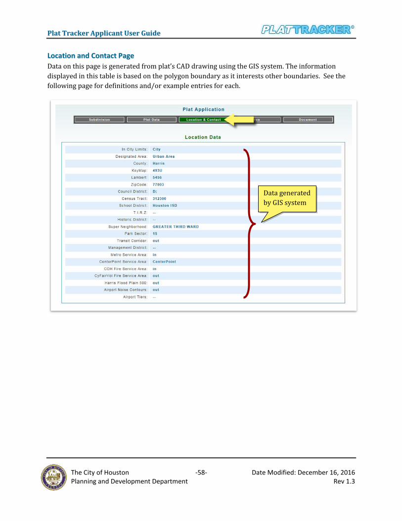
PPllaatt TTrraacckkeerr AApppplliiccaanntt UUsseerr GGuuiiddee
The City of Houston -58- Date Modified: December 16, 2016
Planning and Development Department Rev 1.3
LLooccaattiioonn aanndd CCoonnttaacctt PPaaggee
Data on this page is generated from plat’s CAD drawing using the GIS system. The information
displayed in this table is based on the polygon boundary as it interests other boundaries. See the
following page for definitions and/or example entries for each.
Data generated
by GIS system

PPllaatt TTrraacckkeerr AApppplliiccaanntt UUsseerr GGuuiiddee
The City of Houston -59- Date Modified: December 16, 2016
Planning and Development Department Rev 1.3
LLooccaattiioonn DDaattaa Each item in the location data table is limited to a single location regardless if the plat intersects
multiple locations (zip codes, counties, etc). Only the primary location is listed.
In City Limits: Designated as City (Full) or ETJ (Limited)
Designated area: City name and/or location. Example: City of Houston, Urban Area, Suburb Area,
etc.
County: Fort Bend, Harris, Liberty, Montgomery, or Waller
Key Map: Key map page and location. Example: 100A, 100B, etc.
Lambert: Rectangular/regular grid numbering system. Example: 3020, 3021, etc.
Zipcode: Primary zipcode for the property. Example: 77001, 77002, etc.
Council District: City Council District (A-K)
Census Tract: Census tract number. Example: 100000, 210000, etc.
School District: Alief ISD, Houston ISD, Magnolia ISD, Pasadena ISD, Spring ISD, etc.
TIRZ: Tax Increment Reinvestment Zones are special zones created by City Council to attract new
investment to an area. Example: Eastside, Greenspoint, Market Square, Upper Kirby, Uptown, etc.
Principal contact and
organization info

PPllaatt TTrraacckkeerr AApppplliiccaanntt UUsseerr GGuuiiddee
The City of Houston -60- Date Modified: December 16, 2016
Planning and Development Department Rev 1.3
Historic District: Designated areas that preserve valuable historic resources help in boosting civic
pride, economic prosperity and give residents as well as visitors a visible reminder of our
significant culture and heritage. Example: Audubon Place, Avondale East, Boulevard Oaks, etc.
Super Neighborhood: Geographically designated area where residents, civic organizations,
institutions and businesses work together to identify, plan, and set priorities to address the needs
and concerns of their community. Example: Willowbrook, Greater Greenspoint, Carverdale, etc.
Park Sector: Park sector numbers are 0-21
MUD (County MUD): Municipal Utility Districts, example: Harris County MUD 120, Fort Bend
County MUD 133, etc.
Transit Corridor: Coordinates of land designated for Houston’s Light Rail system. Example:
115700000010. If located in the Transit Corridor area, the value of IN is displayed.
Management District: These districts are empowered to promote, develop, encourage and
maintain employment, commerce, transportation, housing, tourism, recreation, arts, entertainment,
economic development, safety and the public welfare. Example: Houston Downtown, Montrose,
Spring Branch, Westchase, etc.
Metro Service Area: If located in the Houston Metropolitan area, the value of IN is displayed.
Electrical Utility: If located in the Center Point Service area, or Entergy Service area.
COH Fire Service Area: Fire station number designated for that property (1-105). Designate as IN
is displayed.
CyFair Vol. Fire Service area: If located in the CyFair Vol. Fire Service area, the value of IN is
displayed.
Harris Flood Plain 500: If located in the Harris Floodplain 500 area, the value of IN is displayed.
Airport Noise Contours: Typical departure and arrival corridors for aircraft. The configurations
vary based on the prevailing wind conditions. If located in the Airport Noise Contours area, the
value of IN is displayed.
Airport Tier: Example: Hobby Tier 1

PPllaatt TTrraacckkeerr AApppplliiccaanntt UUsseerr GGuuiiddee
The City of Houston -61- Date Modified: December 16, 2016
Planning and Development Department Rev 1.3
FFeeeess
This page shows preliminary and confirmed fees. 'Estimated Amount Fees' are those listed on the
original draft and/or submitted application. 'Verified Amount ($) Fees' are displayed after the
planner reviewed the application. Any variance is shown here. The amounts below are samples and
should not be considered as final as fees changes.

PPllaatt TTrraacckkeerr AApppplliiccaanntt UUsseerr GGuuiiddee
The City of Houston -62- Date Modified: December 16, 2016
Planning and Development Department Rev 1.3
DDooccuummeenntt
A listing of all uploaded files associated with this particular application. The items displayed include
file name, document type, date uploaded, and the person who uploaded the document. Below the
first table are two other tables that displayed the Special Request Forms and Public Hearing
Form.
All Uploaded Files table
All Special Request Forms
and Public Hearing Form

PPllaatt TTrraacckkeerr AApppplliiccaanntt UUsseerr GGuuiiddee
The City of Houston -63- Date Modified: December 16, 2016
Planning and Development Department Rev 1.3
FFiinndd aa SSuubbddiivviissiioonn AApppplliiccaattiioonn NNuummbbeerr In order to submit a Subdivision Name Change, Extension of Approval and Recordation,
applicants are required to provide an application number. There are two ways to find the
appropriate application number:
1. Search plats submitted by your organization, and
2. Search the subdivision database
Any user in the organization may view data for plats formally submitted by your organization.
Select the menu option 'Plat Submittal/My Plat Applications'. At the prompt, click the radio
button, 'Go to All Applications'. A new page will automatically open, 'All Submitted Plat
Applications'. Here, you will see a list of your organization’s plats. Simply click the 'Open' link
beside the plat of interest. For more information go to, Reviewing Submitted Plat Applications
(under, "Go to All Applications") in the earlier part of this Plat Tracker Applicant User Guide
document (above).
If an application was formally submitted by another organization (and an Application Number is
not available), you can follow the steps below or learn in the chapter Subdivision Name Check in
the earlier part of this Plat Tracker Applicant User Guide document (above).
This tool is available to all Plat Tracker users as well as the general public. For access prior to login,
open the Plat Tracker portal page, and click the link: 'Plat Tracker Public Links/Subdivision
Name Check'. If you have already logged into Plat Tracker, find the tool using menu option: 'Plat
Submittal/Check Subdivision Name'. Both methods open the 'Subdivision Names Check' page
where you may validate subdivision name(s) for duplication and uniqueness against the Plat
Tracker database.
Check Subdivision Name is accessed via the menu option 'Plat Submittal/Check Subdivision
Name'.

PPllaatt TTrraacckkeerr AApppplliiccaanntt UUsseerr GGuuiiddee
The City of Houston -64- Date Modified: December 16, 2016
Planning and Development Department Rev 1.3
Type a name or any part of the name into the 'Subdivision Base Name' text field search box, see
"A". Click the 'Check Proposed Subdivision Name' button to display the results Similar or
Duplicate Subdivision Names list. Note that the listing may be associated with a previous
application and/or other organizations. In that case, verify that the subdivision is the correct one
that you are looking for. The Application Number can be found in the column 'AppNo.', see below,
"B".
SSuubbddiivviissiioonn NNaammee CChhaannggee Subdivision Name Change submittal is accessed via the menu option 'Plat Submittal/Subdivision
Name Change'. In order to submit a Subdivision Name Change, applicants are required to provide
an Application Number. Any user in the organization may view data for plats formally submitted by
your organization. If one is not available, see 'Find a Subdivision Application Number' just above
this chapter to find out how.
Subdivision Name associated with the
Application Number on the right.
Verify that that is the correct application
before continuing with the submittal(s).

PPllaatt TTrraacckkeerr AApppplliiccaanntt UUsseerr GGuuiiddee
The City of Houston -65- Date Modified: December 16, 2016
Planning and Development Department Rev 1.3
Subdivision Name Change can only be requested for a plat application within one (1) year after it
is approved or within two (2) years with an extension of approval – without another Subdivision
Name Change currently submitted. Search by entering an Application Number in the text box.
Click the 'Search Application' button when done.
When an Application Number results in a successful find, it displays a set of Current Subdivision
Info. On the right side of the table, enter the New Subdivision Name and other appropriate
information. Check for duplicates by clicking on the 'Check Duplicate' button (see above).
If the process found no duplicates, the next table reveals more information about the application
such as Current Developer, Applicant Information and Fee Information. In the blue section
make the appropriate correction to the Developer Information, if necessary. Click the 'Submit'
button to submit the application.
Enter an Application Number and
click the 'Search Application' button
Enter new Subdivision Name and
other appropriate information. Next
click the 'Check Duplicate' button

PPllaatt TTrraacckkeerr AApppplliiccaanntt UUsseerr GGuuiiddee
The City of Houston -66- Date Modified: December 16, 2016
Planning and Development Department Rev 1.3
Please proceed to the payment process.
You can pay for this Subdivision Name Change now either by going back to the Subdivision Name
Change page to 'Continue to pay now' button (after the submittal) or by selecting Payment
History from Payment menu item.
When the subdivision name change application has been submitted, the Development Services
Division has received the application for the specified plat. Your application is deemed "Pending"
while awaiting staff review of the request, including the successful payment of required name
change fees.
EExxtteennssiioonn ooff AApppprroovvaall Extension of Approval submittal is accessed via the menu option 'Plat Submittal/Extension of
Approval'. In order to submit an Extension of Approval, applicants are required to provide an
Application Number. Any user in the organization may view data for plats formally submitted by
Subdivision Name Change
estimated amount fee due.
Update New Developer Information,
if necessary. Then click the 'Submit'
button below.

PPllaatt TTrraacckkeerr AApppplliiccaanntt UUsseerr GGuuiiddee
The City of Houston -67- Date Modified: December 16, 2016
Planning and Development Department Rev 1.3
your organization. If one is not available, see 'Find a Subdivision Application Number' in the
previous chapter to find out how.
Extension of Approval can only be requested for a plat application within one (1) year after it is approved. Search by entering an Application Number in the text box. Click the 'Search
Application' button when done.
When an Application Number results in a successful find, it displays two sets of tables -- the
Applicant Information and Fee Information tables. Click the 'Submit' button to submit the
application.
Please proceed to the payment process.
Enter an Application Number and
click the 'Search Application' button
Extension of Approval
estimated amount fee due.

PPllaatt TTrraacckkeerr AApppplliiccaanntt UUsseerr GGuuiiddee
The City of Houston -68- Date Modified: December 16, 2016
Planning and Development Department Rev 1.3
You can pay for this Extension of Approval now either by going back to the Extension of Approval
page to 'Continue to pay now' button (after the submittal) or by selecting Payment History from
Payment menu item.
When the extension of approval application has been submitted, the Development Services Division
has received the application for the specified plat. Your application is deemed "Pending" while
awaiting staff review of the request, including the successful payment of required the extension of
approval fees.
RReeccoorrddaattiioonn Recordation submittal is accessed via the menu option 'Plat Submittal/Recordation'. In order to
submit a Recordation, applicants are required to provide an Application Number. Any user in the
organization may view data for plats formally submitted by your organization. If one is not
available, see 'Find a Subdivision Application Number' just above this chapter to find out how.
Search by entering an Application Number in the text box (see below). Click the 'Start
Recordation' button when done.
Enter an Application Number and
click the 'Start Recordation' button
Click here to 'Find a Subdivision
Application Number' if you don’t
know your application number

PPllaatt TTrraacckkeerr AApppplliiccaanntt UUsseerr GGuuiiddee
The City of Houston -69- Date Modified: December 16, 2016
Planning and Development Department Rev 1.3
If a Recordation Request record is already established for a specific plat application by another
organization or entity, Recordation submittal cannot be established. Please contact Plat Tracker
administration if you find an error. A recordation submittal will not be processed if the associated
plat application is not yet approved by the Planning Commission.
When an Application Number results in a successful find, it displays the options to upload several
types of documents. Have the documents ready to be uploaded in the next steps.
Note: Recordation cannot be requested for 'C1', 'C3N', 'C3P', 'C3R', 'GP', and 'VP' application
types.
If no application is found, click the 'Go To Another Recordation' button, and start over again, see
"B". If successful find, go to next steps to upload the documents.
Recordation Status changes to "Draft"
when document(s) has been uploaded.
"Submitted" when the recordation
application has been submitted.
Recordation Status indicator shows
the Recordation in the processing
stages.
Enter a valid Application Number and
take note of the application type that
can only be requested.

PPllaatt TTrraacckkeerr AApppplliiccaanntt UUsseerr GGuuiiddee
The City of Houston -70- Date Modified: December 16, 2016
Planning and Development Department Rev 1.3
This recordation process will be exclusively assigned to your organization once you upload the first
document. Please upload only the relevant document(s) for your plat application recordation.
The list of documents type that can be uploaded:
Title Report, required
Lien Holder’s Subordination Form, if required
Meters and Bounds, if required
Owner’s Ratification Form, if required
Tax Certificates, if required
HCAD Map, if required
Vacating Plat Instrument
Return Map Agreement, if required (not required for City and Harris county plats)
HCAD Information, if required
Others
Select the Document Type first from the dropdown menu list, and then browse to find the
file/document from your computer to upload. Only documents in PDF format are allowed for
upload. 'Title Report(s)' is the most required document. You cannot submit your request unless
the Title Report is uploaded.
Then click on the 'Upload' button. Uploading the same file with the same selected Document Type
will override the previous one. You can upload necessary documents until the recordation request
is accepted by a recordation planner.
Select the type of documents to upload. Click the 'Browse'
button to choose the documents from your computer, next
click the 'Upload' button. Note: 'Title Report' is a required
document. You cannot submit your request unless the
current Title Report is uploaded.

PPllaatt TTrraacckkeerr AApppplliiccaanntt UUsseerr GGuuiiddee
The City of Houston -71- Date Modified: December 16, 2016
Planning and Development Department Rev 1.3
When your specific type of document was uploaded successfully, click on the 'OK ' button to go back
to the Recordation Request page. Select the next Document Type to upload from the dropdown
menu list, if needed.
After the 'Title Report' has been successfully uploaded, the 'Submit' button will appear.
Also, the Fees table will show the estimated fee for the Recordation Plat Submittal. Click the
'Submit' button to submit the application (see above). Once submitted, you can no longer delete
any of the uploaded documents.
Click 'Continue to pay
now' button to pay the fee
or the pay later button.
Recordation estimated
amount fee due.
Applicants can check the notes entered
by the planner for reference during the
process of the recordation.
Uploaded documents

PPllaatt TTrraacckkeerr AApppplliiccaanntt UUsseerr GGuuiiddee
The City of Houston -72- Date Modified: December 16, 2016
Planning and Development Department Rev 1.3
You can pay for this Recordation Request now either by going back to the Recordation Request
page to 'Continue to pay now' button (after the submittal) or by selecting Payment History from
Payment menu item.
Please pay the fees prior to scheduling a meeting appointment with recordation planner. No review
is performed unless the fees are fully paid.
Applicants can log into Plat Tracker anytime to check the status of the recordation application and
see notes entered by the planner for reference.
When the recordation application has been submitted, the Development Services Division has
received your recordation application for the specified plat. Your application is deemed "Pending"
while awaiting staff review of all the submitted documents, including the successful payment of
required recordation fees.
You recordation includes an appointment with the planner. Please book a recordation appointment
on www.clickbook.net (1 hour per plat), at least two (2) days in advance. Wait for an appointment
confirmation email from the planner, one day before the meeting to ensure all the required
documents are uploaded.
In order to cancel an application, call the recordation planner at least one (1) hour prior to the
scheduled meeting time.
At the recordation appointment, you will meet with the planner and make any minor corrections, if
needed. All required hard copies of the documents must be provided at this time. Once the
recordation application is accepted during the meeting, it will be sent for signatures for
recordation.
If an application requires additional information, it will be deemed "Incomplete" and will remain
pending in the system. The "incomplete" email sent to the applicant will contain a list of delinquent
items. All requested information must be provided and uploaded to Plat Tracker prior to the
appointment, or the appointment will be forfeited. You may book a new appointment on Clickbook
once the application is ready.
If you have any questions, please contact the planner with whom your appointment is scheduled.
The list of materials should be provided before or at the Recordation Appointment:
Mylar with all required signatures
Tax Certificates
Easements Exhibit, if required
Lien Holder’s Subordination Form, if required
Agency release letters, if required

PPllaatt TTrraacckkeerr AApppplliiccaanntt UUsseerr GGuuiiddee
The City of Houston -73- Date Modified: December 16, 2016
Planning and Development Department Rev 1.3
Return map agreement, if required (not required for City and Harris county plats)
When Recordation Applications have been accepted, the mylar will be sent to the County Clerk or
County Engineers Office. Once the mylar has been recorded and scanned, applicants will be notified
by e-mail. The final Recordation Status should say "Recorded".
Final Recordation Status
will say "Recorded" when
recordation is completed.

PPllaatt TTrraacckkeerr AApppplliiccaanntt UUsseerr GGuuiiddee
The City of Houston -74- Date Modified: December 16, 2016
Planning and Development Department Rev 1.3
PPllaatt AApppplliiccaattiioonn AApppprroovvaall TTiimmeelliinnee The following graph represents the two week Planning Commission cycle.
Submittal Window Deferral Window
Friday 6:00 AM to Monday 11:00 AM: The application submittal window is open on the Friday Following Planning Commission until 11:00 AM on the following Monday. Applications are submitted through the Plat Tracker. Requirement may be found online or in Chapter 42, Div 2 application requirements.
Submittal window closes at 11:00AM on Monday
Individuals with applications that were deferred during the previous planning commission cycle must provide the revised information to staff before noon on Wednesday following submittal. If any of the necessary information is not received, the staff will recommend disapproval of the application.
Deferral window closes at noon on Wednesday
Review Phase Planning Commission
The planning staff reviews the application for compliance and determines recommendation. Applicants should be prepared to provide additional information as requested. Revisions to applications that were deferred previously will not be accepted during this phase.
Staff notifies applicant on their recommendation by the end of the day Wednesday
Planning Commission is held every other Thursday at 2:30PM in the Council Chambers of City Hall Annex (900 Bagby Street – Public Level).