Pow Beck, St Bees to Seascale promenade
15
Coastal Access | Whitehaven to Silecroft | Natural England’s Proposals | Chapter 2: Pow Beck, St Bees to Seascale promenade www.naturalengland.org.uk Chapter 2: Pow Beck, St Bees to Seascale promenade Coastal Access: Whitehaven to Silecroft - Natural England’s Proposals Part 2.1: Introduction Start Point: Pow Beck, St Bees (grid reference: NX 969 511) End Point: Seascale promenade (grid reference: NY 037 009) Relevant Maps: 2a to 2g Understanding the proposals and accompanying maps: The Trail: 2.1.1 Generally follows existing walked routes, including public rights of way, south of Braystones. The majority of the route between St Bees and Nethertown does not follow any existing walked route and will require the creation of a new path. See maps 2a to 2g and associated tables below for details. 2.1.2 Mainly follows the coastline quite closely and maintains good views of the sea. 2.1.3 Is aligned on tracks at the top of the foreshore in the vicinity of Braystones and as far south as High Sellafield. 2.1.4 Generally takes a different route to the existing Cumbria Coastal Way as far south as Nethertown/ Braystones, to avoid long sections on a shingle beach. From Braystones southwards to the end of this length, the route is similar to the existing Cumbria Coastal Way. 2.1.5 This part of the coast includes the following sites, designated or identified for nature conservation or heritage preservation reasons (See map C of the Overview): St Bees Head Site of Special Scientific Interest (SSSI) for its geological /wildlife interest Silver Tarn, Hollas & Harnsey mosses Site of Special Scientific Interest (SSSI) for its biological interest Seascale Foreshore and Dunes County Wildlife Site Braystones County and Local Wildlife Site Starling Castle County and Local Wildlife Site We have assessed the potential impacts of access along the proposed route (and over the associated spreading room described below) on the features in question and on any which are protected in their own right. 2.1.6 The proposed route largely follows popular existing paths in the vicinity of southern St Bees Head and the Seascale Foreshore and Dunes. For this reason, we do not expect the levels and patterns
Transcript of Pow Beck, St Bees to Seascale promenade
Coastal Access | Whitehaven to Silecroft | Natural England’s Proposals | Chapter 2: Pow Beck, St Bees to Seascale promenade
www.naturalengland.org.uk
Chapter 2:
Pow Beck, St Bees to Seascale promenadeCoastal Access: Whitehaven to Silecroft - Natural England’s Proposals
Part 2.1: Introduction
Start Point: Pow Beck, St Bees (grid reference: NX 969 511)
End Point: Seascale promenade (grid reference: NY 037 009)
Relevant Maps: 2a to 2g
Understanding the proposals and accompanying maps:
The Trail:
2.1.1 Generally follows existing walked routes, including public rights of way, south of Braystones. The majority of the route between St Bees and Nethertown does not follow any existing walked route and will require the creation of a new path. See maps 2a to 2g and associated tables below for details.
2.1.2 Mainly follows the coastline quite closely and maintains good views of the sea.
2.1.3 Is aligned on tracks at the top of the foreshore in the vicinity of Braystones and as far south as High Sellafield.
2.1.4 Generally takes a different route to the existing Cumbria Coastal Way as far south as Nethertown/Braystones, to avoid long sections on a shingle beach. From Braystones southwards to the end of this length, the route is similar to the existing Cumbria Coastal Way.
2.1.5 This part of the coast includes the following sites, designated or identified for nature conservation or heritage preservation reasons (See map C of the Overview):
St Bees Head Site of Special Scientific Interest (SSSI) for its geological /wildlife interest
Silver Tarn, Hollas & Harnsey mosses Site of Special Scientific Interest (SSSI) for its biological interest
Seascale Foreshore and Dunes County Wildlife Site
Braystones County and Local Wildlife Site
Starling Castle County and Local Wildlife Site
We have assessed the potential impacts of access along the proposed route (and over the associated spreading room described below) on the features in question and on any which are protected in their own right.
2.1.6 The proposed route largely follows popular existing paths in the vicinity of southern St Bees Head and the Seascale Foreshore and Dunes. For this reason, we do not expect the levels and patterns
Coastal Access | Whitehaven to Silecroft | Natural England’s Proposals | Chapter 2: Pow Beck, St Bees to Seascale promenade
of public access to change significantly as a result of our proposals. Whilst the Harnsey Moss, Braystones and Starling Castle sites lie fairly close to the proposed route, they are not within the proposed margin. We have therefore concluded that our proposals would not be likely to have any significant impact on these features.
2.1.7 In relation to those nature conservation sites listed above, refer to our published Access & Sensitive Feature Appraisal for more information.
See part 5b of the Overview - ‘Natural environment’ - for more information.
Accessibility
2.1.8 Generally, whilst there are few artificial barriers to accessibility on the proposed route, much of this length will not be easily accessible by people with reduced mobility. This is due to undulating terrain with some steeper slopes, steps and sections on sand dunes & shingle. However, the southern part of this length, from Sellafield station to Seascale, follows an existing cycle path and should be readily accessible by all.
2.1.9 Between St Bees and Nethertown, and in various other locations, the creation of a new path will involve installation of many stock-proof gates. We envisage this happening as part of the physical establishment work described in part 6 of the Overview. All such items will adhere to National Trail standards.
See part 5a of the Overview - ‘Recreational issues’ - for more information.
Where we have proposed exercising our discretion
The discretions referred to below are explained in more detail the Overview.
2.1.10 Estuaries: This report proposes that the trail should cross the estuary of the river Calder over the first public crossing point, which is at the mouth of the estuary. (The route of the trail along the open coast also crosses the River Ehen nearby, because there is no viable seaward route along the open coast at this point.) See map 2f.
2.1.11 Landward boundary of the coastal margin: We have used our discretion on some sections of the route to map the landward extent of the coastal margin to an adjacent physical boundary such as a fence line, pavement or track to make the extent of the new access rights clearer. See Table 2.2.1 below.
2.1.12 At Seascale, we have used our discretion to propose the inclusion of additional, more extensive landward areas within the coastal margin, to secure or enhance public enjoyment of this part of the coast. The owner of this land is content for us to propose this. See Table 2.2.1 below and map 2g for more information.
See part 3 of the Overview - ‘Understanding the proposals and accompanying maps’, for an explanation of the default extent of the coastal margin and how we may use our discretion to adjust the margin, either to add land or to provide clarity. See also Annex C of the Overview - ‘Excepted land categories’.
2.1.13 Restrictions and/or exclusions: Access rights to the spreading room would be subject to the national restrictions on coastal access rights listed in Annex D of the Overview. These restrictions would not apply to public rights of way.
2.1.14 We propose to permanently exclude access to an area of seaward margin adjacent to sections WHS-2-S038 & WHS-2-S039 for reasons of public safety in relation to a motorcycle scramble track on the land. This exclusion will not affect the route itself. See map D in the Overview for details.
2.1.15 We propose to give an ‘outline direction’ to enable exclusion when necessary of access to an area of seaward margin on the spit of land seawards of the river Ehen adjacent to sections WHS-2-S056 to WHS-2-S062, for reasons of land management and public safety in relation to ongoing
Coastal Access | Whitehaven to Silecroft | Natural England’s Proposals | Chapter 2: Pow Beck, St Bees to Seascale promenade
operational activities which at times may impact upon this area of land. Such exclusions would not affect the route itself. See map E in the Overview for details.
See part 9 of the Overview - ‘Restrictions and exclusions’ - for details.
2.1.16 Temporary routes: At the time of writing this report, there are no requirements for temporary routes. However, refer to ‘Future change’ below.
2.1.17 Alternative routes: At the time of writing this report, we do not foresee the need for any alternative routes.
2.1.18 Establishment: Some physical establishment of the trail would be necessary, in accordance with the general approach described in part 6 the Overview. This would include works to create a new path between St Bees and Nethertown/Braystones, including many new field boundary crossings.
2.1.19 Ongoing management: Ongoing management and maintenance would be necessary in accordance with the general approach described in part 7 of the Overview.
See part 6 - ‘Physical establishment of the trail’ and part 7 - ‘Maintenance of the trail’ of the Overview for more information.
Future Change
2.1.20 Parts of the route of the trail on this length of coast would be able to change without further approval from the Secretary of State in response to coastal erosion or other geomorphological processes, or encroachment by the sea. This would happen in accordance with the criteria and procedures for ‘roll back’ set out in part 8 of the Overview. See table 2.2.1 below for details of the sections likely to be affected in the foreseeable future.
2.1.21 In the vicinity of the Sellafield nuclear installation and the Moorside development area, we foresee a likely need for changes to the access provisions to allow for exploratory or construction works associated with any development of a new nuclear facility or the operation or decommissioning of the existing facility. Any short to medium term restriction required over the trail would require the provision of a temporary route, whilst any permanent impact on the trail would lead to the proposal of a new route in the future by means of a variation report. This is further explained at part 8 of the Overview.
See part 5e - ‘Coastal processes’ and part 8 - ‘Future changes’ of the Overview for more information.
Coastal Access | Whitehaven to Silecroft | Natural England’s Proposals | Chapter 2: Pow Beck, St Bees to Seascale promenade
Part 2.2: Commentary on MapsSee Part 3 of Overview for guidance on reading and understanding the tables below
2.2.1 Section Details – Maps 2a to 2g: Pow Beck, St Bees to Seascale promenade
Notes on table:Column 2 – an asterisk (*) against the route section number means see also table 2.2.2: Other options considered.Column 5 – ‘Yes – normal’ means roll-back approach is likely to follow the current feature (e.g. cliff edge/beach) for the
foreseeable future.Column 5 – ‘Yes – see table 2.2.3’ means refer to that table below about our likely approach to roll-back on this part of the route.
1 2 3 4 5 6a 6b 7Map(s) Route section
number(s) Current status of this section
Current surface of this section
Roll-back proposed?(See Part 8 of Overview)
Landward boundary of margin (See maps)
Reason for landward boundary discretion
Proposed exclusions or restrictions(see Part 9 of Overview)
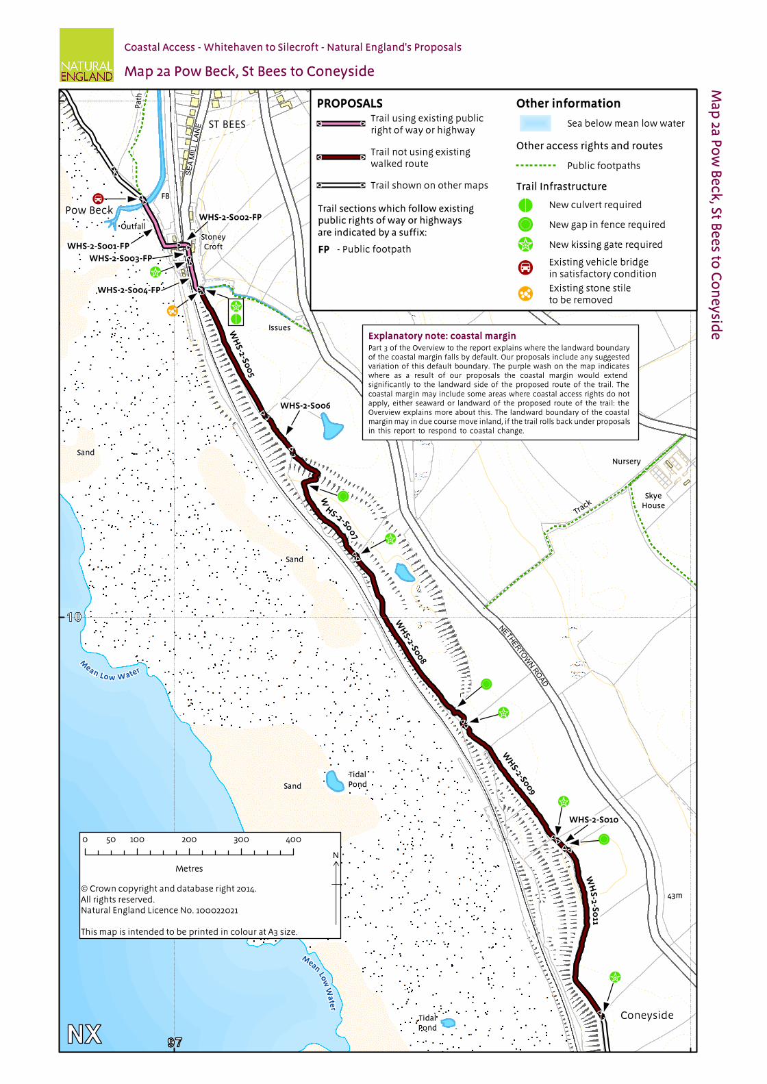
2a WHS-2-S001* Public Footpath Gravel Yes - Normal
Landward edge of trail
Not used None
WHS-2-S002* Public Footpath Concrete No Landward edge of trail
Not used None
WHS-2-S003* Public Footpath Concrete No Landward edge of road
Clarity & Cohesion None
WHS-2-S004* Public Footpath Grass No Wall Clarity & Cohesion NoneWHS-2-S005* to WHS-2-S008*
Not an existing walked route
Grass Yes - Normal
Landward edge of trail
Not used None
WHS-2-S009* Not an existing walked route
Grass Yes - Normal
Landward edge of trail
Not used None
WHS-2-S010* & WHS-2-S011*
Not an existing walked route
Grass Yes - Normal
Landward edge of trail
Not used None
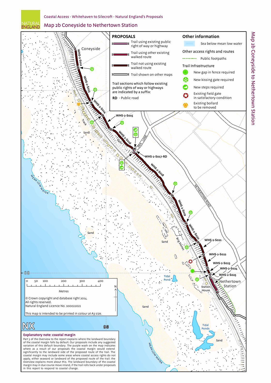
2b WHS-2-S012* to WHS-2-S015*
Not an existing walked route
Grass Yes - Normal
Landward edge of trail
Not used None
WHS-2-S016* Not an existing walked route
Bare Soil (compacted)
Yes - Normal
Landward edge of trail
Not used None
WHS-2-S017* Public Highway Gravel Yes - Normal
Landward edge of trail
Not used None
WHS-2-S018* to WHS-2-S024*
Not an existing walked route
Grass Yes - Normal
Landward edge of trail
Not used None
WHS-2-S025* to WHS-2-S027
Other existing walked route
Gravel No Landward edge of trail
Not used None
WHS-2-S028 Other existing walked route
Gravel No Landward edge of trail
Not used None
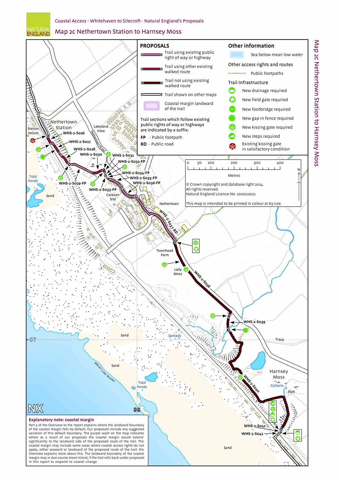
2c WHS-2-S029 Public Footpath Grass No Fence Clarity & Cohesion NoneWHS-2-S030 & WHS-2-S031
Other existing walked route
Grass No Fence Clarity & Cohesion None
WHS-2-S032 Public Footpath Grass No Fence Clarity & Cohesion NoneWHS-2-S033 Public Footpath Bare Soil
(compacted)No Fence Clarity & Cohesion None
WHS-2-S034 Public Footpath Grass No Fence Clarity & Cohesion NoneWHS-2-S035 Public Footpath Gravel No Fence Clarity & Cohesion NoneWHS-2-S036 Public Footpath Tarmac No Fence Clarity & Cohesion NoneWHS-2-S037* Public Highway Tarmac No Landward edge
of roadClarity & Cohesion None
WHS-2-S038* Not an existing walked route
Grass No Wall/hedge Clarity & Cohesion Margin
WHS-2-S039* Not an existing walked route
Grass No Landward edge of trail
Not used Margin
WHS-2-S040* & WHS-2-S041*
Not an existing walked route
Grass Yes – Normal
Landward edge of trail
Not used None
WHS-2-S042* Not an existing walked route
Gravel Yes – See table 2.2.3
Landward edge of trail
Not used None
Coastal Access | Whitehaven to Silecroft | Natural England’s Proposals | Chapter 2: Pow Beck, St Bees to Seascale promenade
1 2 3 4 5 6a 6b 7Map(s) Route section
number(s) Current status of this section
Current surface of this section
Roll-back proposed?(See Part 8 of Overview)
Landward boundary of margin (See maps)
Reason for landward boundary discretion
Proposed exclusions or restrictions(see Part 9 of Overview)
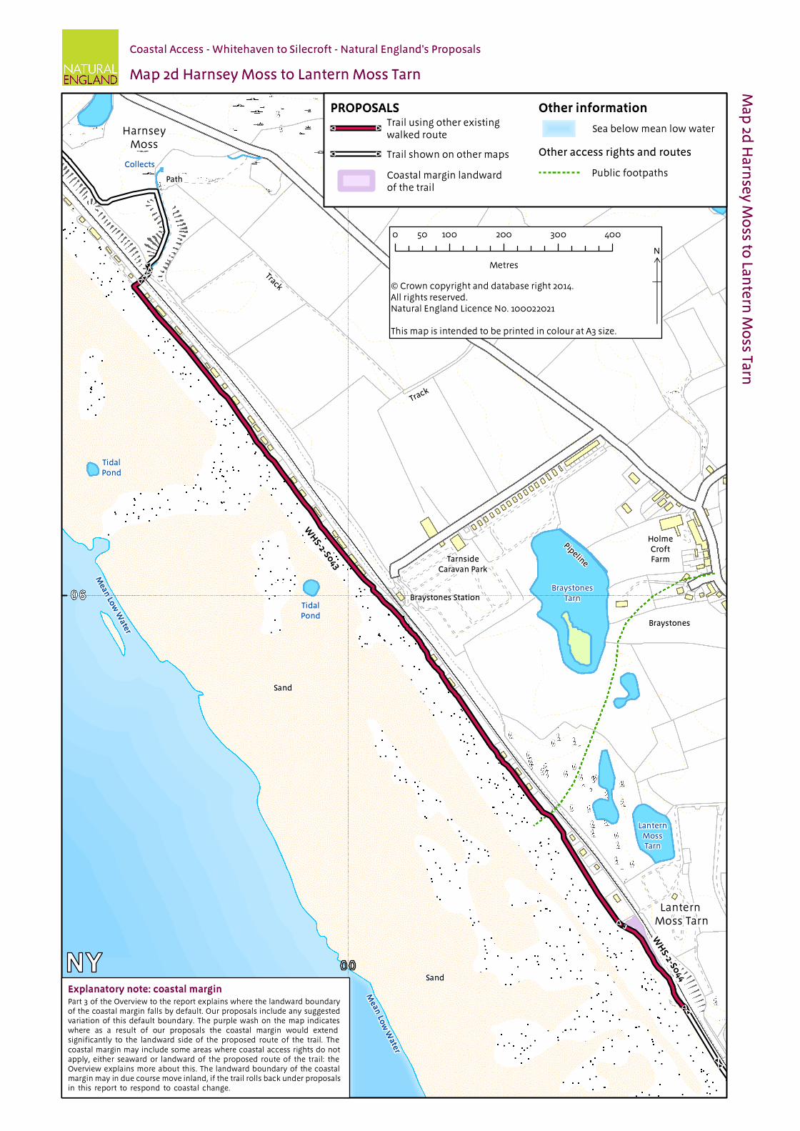
2d WHS-2-S043 Other existing walked route
Gravel Yes – See table 2.2.3
Landward edge of trail
Not used None
WHS-2-S044 Other existing walked route
Sand Yes – See table 2.2.3
Fence Clarity & Cohesion None
2e WHS-2-S045 Other existing walked route
Gravel Yes – See table 2.2.3
Fence Clarity & Cohesion None
WHS-2-S046 Other existing walked route
Sand Yes – See table 2.2.3
Fence Clarity & Cohesion None
WHS-2-S047 Other existing walked route
Grass Yes – See table 2.2.3
Fence Clarity & Cohesion None
WHS-2-S048 Other existing walked route
Sand Yes – See table 2.2.3
Fence Clarity & Cohesion None
WHS-2-S049 Other existing walked route
Grass Yes – See table 2.2.3
Fence Clarity & Cohesion None
WHS-2-S050 Other existing walked route
Bare Soil (compacted)
Yes – See table 2.2.3
Wall Clarity & cohesion None
WHS-2-S051 Other existing walked route
Grass Yes – See table 2.2.3
Landward edge of trail
Not used None
WHS-2-S052 Other existing walked route
Steps: Timber Yes – See table 2.2.3
Fence Clarity & Cohesion None
WHS-2-S053 Other existing walked route
Gravel Yes – See table 2.2.3
Landward edge of bridge
Clarity & Cohesion None
WHS-2-S054 Other existing walked route
Steps: Timber Yes – See table 2.2.3
Fence Clarity & Cohesion None
WHS-2-S055 Other existing walked route
Grass No Fence Clarity & cohesion None
WHS-2-S056 Not an existing walked route
Grass No Landward edge of trail
Not used Margin
2f WHS-2-S057 & WHS-2-S058
Not an existing walked route
Grass No Landward edge of trail
Not used Margin
WHS-2-S059 Not an existing walked route
Grass No Fence Clarity & Cohesion Margin
WHS-2-S060 Public footway (pavement)
Tarmac No Fence Clarity & Cohesion Margin
WHS-2-S061 Road Tarmac No Landward edge of trail
Not used Margin
WHS-2-S062 Cycleway Tarmac No Fence Clarity & Cohesion MarginWHS-2-S063 Cycleway
(bridge)Tarmac No Fence/Landward
edge of bridge Clarity & cohesion None
WHS-2-S064 Cycleway Bare Soil (compacted)
No Landward edge of trail
Not used None
WHS-2-S065 Cycleway Bare Soil (compacted)
No Landward edge of trail
Not used None
WHS-2-S066 Cycleway Tarmac/gravel
No Landward edge of cycle path
Clarity & Cohesion None
2g WHS-2-S067 Cycleway Tarmac/gravel
No Landward edge of cycle path
Clarity & Cohesion None
WHS-2-S068 Cycleway Gravel No Landward edge of cycle path
Clarity & Cohesion None
WHS-2-S069 Other existing walked route
Concrete No Landward edge of trail
No proposal None
WHS-2-S070 Other existing walked route
Tarmac No Various Additional landward area
None
Coastal Access | Whitehaven to Silecroft | Natural England’s Proposals | Chapter 2: Pow Beck, St Bees to Seascale promenade
2.2.2 Other options considered: Maps 2a to 2c: St Bees to Braystones
Map(s) Section number(s)
Option(s) considered Reasons for not proposing this option as the route
2a & 2b
WHS-2-S001 to WHS-2-S026
We considered aligning the trail along the foreshore.
The trail will not normally be aligned on shingle beaches because it can be difficult to walk on for any distance and may be partly covered by tides. We would only propose a route along shingle for a short distance where there are no other viable route options.
2c WHS-2-S037 to WHS-2-S042
We considered aligning the trail along the road from Nethertown that leads over the railway line and onto a short section of access track and then onto the foreshore.
The trail will not normally be aligned on shingle beaches because it can be difficult to walk on for any distance and may be partly covered by tides. We would only propose a route along shingle for a short distance where there are no other viable route options.
2.2.3 Roll-back implementation – more complex situations: Map 2c to 2e: Nethertown to High Sellafield
Map(s) Section number(s)
Feature or site potentially affected
How we will manage roll-back in relation to this feature or site
2c to 2e
WHS-2-S042 to WHS-2-S054
Beach front properties and coastal railway.
If it is no longer possible to find a viable route seaward of the specified excepted land (including buildings, curtilage, gardens, railway etc), we will choose a route landward of it, following discussions with owners and occupiers. Adjoining sections, for which roll-back is also proposed, may well need to change in order to retain the continuity of the trail.
Note: In relation to all other sections where roll-back has been proposed, the trail is likely to be adjusted to follow the current feature (e.g. cliff edge/beach) for the foreseeable future.
Coastal Access | Whitehaven to Silecroft | Natural England’s Proposals | Chapter 2: Pow Beck, St Bees to Seascale promenade
Part 2.3: Chapter 2 - Formal Proposals Below are our formal proposals to the Secretary of State for the length of coast shown on maps 2a to 2g.
They should be read in conjunction with the relevant maps.
The commentary above explains the practical effect of these proposals.
Formal Proposals – Pow Beck, St Bees to Seascale promenade
Discretion to include an estuary
2.3.1 Natural England proposes to exercise its functions, so far as may be necessary in the circumstances, as if the sea included the estuarial waters of the river Calder as far as the first bridge with public access, as indicated by the extent of the trail shown on maps 2e & 2f.
Proposed route of the trail
2.3.2 In relation to route sections WHS-2-S002 to WHS-2-S004, WHS-2-S0025 to WHS-2-S039 and WHS-2-S056 to WHS-2-S070, the route is to be at the centre of the line shown on maps 2a to 2g as the proposed route of the trail.
2.3.3 In relation to route sections WHS-2-S001, WHS-2-S005 to WHS-2-S024, and WHS-2-S040 to WHS-2-S054 the route, as initially determined at the time the report was prepared, is to be at the centre of the line shown on maps 2a to 2e as the proposed route of the trail.
2.3.4 If at any time any part of a route section listed in the previous paragraph needs, in Natural England’s view, to change, as a result of coastal erosion or other geomorphological processes or encroachment by the sea, in order for the overall route to remain viable, the new route for the part in question will be determined by Natural England without further reference to the Secretary of State. This will be done in accordance with the criteria and procedures described under the title ‘Roll-back’ in part 8 of the Overview and section 4.10 of the Coastal Access Scheme. If this happens, the new route will become the approved route for that section for the purposes of the Order which determines where coastal access rights apply.
Landward boundary of coastal margin
2.3.5 Adjacent to route sections WHS-2-S003 and WHS-2-S037, the landward boundary of the coastal margin is to coincide with the landward edge of the road shown as the trail, as shown on maps 2a & 2c.
2.3.6 Adjacent to route section WHS-2-S004 the landward boundary of the coastal margin is to coincide with the existing boundary wall landward of the trail, as shown on map 2a.
2.3.7 Adjacent to route sections WHS-2-S029 to WHS-2-S036, WHS-2-S055, WHS-2-S059, WHS-2-S060 and WHS-2-S062, the landward boundary of the coastal margin is to coincide with the existing boundary fence landward of the trail, as shown on maps 2c, 2e & 2f.
2.3.8 Adjacent to route sections WHS-2-S038 and WHS-2-S050, the landward boundary of the coastal margin is to coincide with the existing boundary wall which, at the time of writing this report, is landward of the trail, as shown on maps 2c & 2e.
2.3.9 Adjacent to route sections WHS-2-S044 to WHS-2-S049, WHS-2-S052 and WHS-2-S054 the landward boundary of the coastal margin is to coincide with the existing boundary fence which, at the time of writing this report, is landward of the trail, as shown on maps 2d & 2e.

Coastal Access | Whitehaven to Silecroft | Natural England’s Proposals | Chapter 2: Pow Beck, St Bees to Seascale promenade
2.3.10 Adjacent to route section WHS-2-S053, the landward boundary of the coastal margin is to coincide with the landward edge of the bridge which, at the time of writing this report, is landward of the trail, as shown on map 2e.
2.3.11 Adjacent to route section WHS-2-S063 the landward boundary of the coastal margin is to coincide with the existing fence and the landward edge of the bridge, both of which are landward of the trail, as shown on map 2f.
2.3.12 Adjacent to route sections WHS-2-S066 to WHS-2-S068, the landward boundary of the coastal margin is to coincide with the landward edge of the cycle path shown as the trail on maps 2f & 2g.
2.3.13 Adjacent to route section WHS-2-S070, the landward boundary of the coastal margin is to coincide with seaward edge of the roads and car park, as indicated by the coastal margin landward of the trail on map 2g.
Local restrictions and exclusions
2.3.14 Natural England proposes to restrict or exclude access relevant to this length of coast, as follows:
Access to the parts of the margin seawards of sections WHS-2-S038 & WHS-2-S039 is to be excluded permanently for reasons of public safety in relation to a motorcycle scramble track on the land. (See map D in the Overview).
Access to parts of the margin on the spit of land seaward of the river Ehen is to be excluded from time to time, as required, for reasons of land management and public safety in connection with operations undertaken by the nuclear management authorities. This exclusion will not affect the route itself. (See Map E in the Overview).
Alternative routes
2.3.15 There are no proposals for alternative routes in relation to this length of coast.
#
#
#
#
#
#
#
#
#
#
#
#
#
#
#
#
#
#
#
#
#
#
#
#
#
#
#
#
#
#
#
#
#
#
#
#
#
#
#
#
#
#
#
#
#
#
!̀
!̀!ü
!(
!̀
!(
!=
!̀
!(
!P
!̀
!̀
NETHERTOWN ROAD
SEAM
ILLLA
NE
TidalPond
TidalPond
Issues
Sand
Sand
Coneyside
Deep
gill Banks
FB
FB
Outfall
Pa
th
Track
AncientFishgarth
SandNursery
SkyeHouse
StoneyCroft
43m
72m
Pow Beck
Mean
Low
Wa
ter
Mean Lo w W ater
ST BEES
WHS-2-S001-FP
WHS-2-S004-FP
WHS-2-S003-FP
WH
S-2-S00
5
WHS-2-S006
W
HS-2-S007
WH
S-2-S00
8
WH
S-2-S009
WHS-2-S010
WH
S-2-S
011
WHS-2-S002-FP
Map 2a Pow Beck, St Bees to Coneyside
Ma
p 2a
Po
w B
ec
k, St B
ee
s to C
on
ey
side
Coastal Access - Whitehaven to Silecroft - Natural England's Proposals
Explanatory note: coastal marginPart 3 of the Overview to the report explains where the landward boundary of the coastal margin falls by default. Our proposals include any suggested variation of this default boundary. The purple wash on the map indicates where as a result of our proposals the coastal margin would extend significantly to the landward side of the proposed route of the trail. The coastal margin may include some areas where coastal access rights do not apply, either seaward or landward of the proposed route of the trail: the Overview explains more about this. The landward boundary of the coastal margin may in due course move inland, if the trail rolls back under proposals in this report to respond to coastal change.
Other informationPROPOSALS
Other access rights and routes
Sea below mean low water
Trail sections which follow existingpublic rights of way or highwaysare indicated by a suffix:
Trail using existing publicright of way or highway
#
#
Public footpaths
N
ש Crown copyright and database right 2014. All rights reserved.Natural England Licence No. 100022021
This map is intended to be printed in colour at A3 size.
0 100 200 300 40050
Metres
#
# Trail not using existingwalked route
- Public footpathFP
Trail shown on other maps#
#
Trail Infrastructure
!üExisting stone stile to be removed
Existing vehicle bridgein satisfactory condition!P
New kissing gate required!̀
New gap in fence required!(!= New culvert required
SEALA
NE
NETHERTOWN ROAD
Nethertown Road
TidalPond
TidalPonds
TidalPond
Path
Path
Path
Track
Sand
Coneyside
Sand
Sand
Brig Ston
es
Sand
Sand
Sand
Track
ConeysideFarm
High
Noon
StationHouse
LakelandView
RoseCottage
NethertownStation
42m
ME
AN
LOW
W
ATER
ME
AN
LOW
WATER
WH
S-2-S0
12W
HS-2-S0
13
WH
S-2-S014
WHS-2-S015
WH
S-2-S016
WHS-2-S017-RD
WH
S-2-S018
WH
S-2-S019
WH
S-2-S020
WHS-2-S021
WHS-2-S022
WHS-2-S023
WHS-2-S024
WHS-2-S025
Map 2b Coneyside to Nethertown Station
Ma
p 2b
Co
ne
ysid
e to
Ne
the
rtow
n Sta
tion
Coastal Access - Whitehaven to Silecroft - Natural England's Proposals
Explanatory note: coastal marginPart 3 of the Overview to the report explains where the landward boundary of the coastal margin falls by default. Our proposals include any suggested variation of this default boundary. The purple wash on the map indicates where as a result of our proposals the coastal margin would extend significantly to the landward side of the proposed route of the trail. The coastal margin may include some areas where coastal access rights do not apply, either seaward or landward of the proposed route of the trail: the Overview explains more about this. The landward boundary of the coastal margin may in due course move inland, if the trail rolls back under proposals in this report to respond to coastal change.
N
© Crown copyright and database right 2014. All rights reserved.Natural England Licence No. 100022021
This map is intended to be printed in colour at A3 size.
0 100 200 300 40050
Metres
Other informationPROPOSALS
Other access rights and routes
Sea below mean low water
Trail sections which follow existingpublic rights of way or highwaysare indicated by a suffix:
Trail shown on other maps
Trail using existing publicright of way or highway
Trail using other existingwalked route Public footpaths
- Public roadRD
Trail not using existingwalked route
Trail Infrastructure
New gap in fence required
New kissing gate required
New steps required
Existing field gate in satisfactory condition
Existing bollard to be removed
NETHERTOWN ROAD
Nethertown Road
Collects
Spreads
TidalPonds
TidalPonds
LadyMoss
Nethertown
HarnseyMoss
Path
Track
Track
Sand
Sand
Sand
Sand
CaravanSite
StationHouse
TownheadFarm
LakelandView
NethertownStation
Mean
LowW
ater
WHS-2-S026
WHS-2-S027
WHS-2-S028
WHS-2-S029-FP
WHS-2-S030
WHS-2-S032-FP
WHS-2-S033-FP
WHS-2-S035-FP
W
HS-2-S0
37-RD
WHS-2-S036-FP
WH
S-2-S038
WHS-2-S039
WH
S-2-S040
WHS-2-S034-FP
WHS-2-S041
WHS-2-S042
WHS-2-S031
Map 2c Nethertown Station to Harnsey Moss
Ma
p 2c N
eth
erto
wn
Statio
n to
Ha
rnse
y M
oss
Coastal Access - Whitehaven to Silecroft - Natural England's Proposals
Explanatory note: coastal marginPart 3 of the Overview to the report explains where the landward boundary of the coastal margin falls by default. Our proposals include any suggested variation of this default boundary. The purple wash on the map indicates where as a result of our proposals the coastal margin would extend significantly to the landward side of the proposed route of the trail. The coastal margin may include some areas where coastal access rights do not apply, either seaward or landward of the proposed route of the trail: the Overview explains more about this. The landward boundary of the coastal margin may in due course move inland, if the trail rolls back under proposals in this report to respond to coastal change.
N
© Crown copyright and database right 2014. All rights reserved.Natural England Licence No. 100022021
This map is intended to be printed in colour at A3 size.
0 100 200 300 40050
Metres
Other informationPROPOSALS
Other access rights and routes
Sea below mean low water
Trail sections which follow existingpublic rights of way or highwaysare indicated by a suffix:
Trail using existing publicright of way or highway
Trail using other existingwalked route Public footpaths
Trail not using existingwalked route
- Public roadRD
- Public footpathFP
Trail Infrastructure
Trail shown on other maps
Coastal margin landwardof the trail
Existing kissing gate in satisfactory condition
New drainage required
New field gate required
New footbridge required
New gap in fence required
New kissing gate required
New steps required
Track
Mean
Low
Water
Sand
LanternMoss
CaravanPark
Lantern Moss Tarn
LanternMossTarn
Sand
Mean
Low
Water
TidalPond
Braystones
Braystones StationBraystones
Tarn
TarnsideCaravan Park
Pipeline
HolmeCroftFarm
TidalPond
Track
Track
Collects
HarnseyMoss
Path
WH
S-2-S044
WH
S-2-S043
Map 2d Harnsey Moss to Lantern Moss Tarn
Ma
p 2d
Ha
rnse
y M
oss to
Lan
tern
Mo
ss Tarn
Coastal Access - Whitehaven to Silecroft - Natural England's Proposals
Explanatory note: coastal marginPart 3 of the Overview to the report explains where the landward boundary of the coastal margin falls by default. Our proposals include any suggested variation of this default boundary. The purple wash on the map indicates where as a result of our proposals the coastal margin would extend significantly to the landward side of the proposed route of the trail. The coastal margin may include some areas where coastal access rights do not apply, either seaward or landward of the proposed route of the trail: the Overview explains more about this. The landward boundary of the coastal margin may in due course move inland, if the trail rolls back under proposals in this report to respond to coastal change.
N
© Crown copyright and database right 2014. All rights reserved.Natural England Licence No. 100022021
This map is intended to be printed in colour at A3 size.
0 100 200 300 40050
Metres
Other informationPROPOSALS
Other access rights and routes
Sea below mean low water
Public footpaths
Trail using other existingwalked route
Trail shown on other maps
Coastal margin landwardof the trail
TidalPond
Sand
RiverEh
en
River Ehen
TidalPond
Track
Track
Mean
Low
Wa
ter
Unde
rpas
s
WatchHill
HighSellafield
Banks
Dis
ma
ntl
ed
Ra
ilw
ay
Drain
Drain Drain
Bogholes
Trac
k
Rive
rE
he
n
Drain
Track
Spr
WaterWorks
Drain
WarboroughNook
LanternMoss
CaravanPark
Trac
k
Lantern Moss Tarn
Collects
Spreads
Tra
ck
Colls
LanternMossTarn
SpreadsW
HS-2-S0
56
WHS-2-S048
WH
S-2-
S 050
WH S-2 -S 05 3
WHS-2-S0 49
WHS-2-S0 54
WH
S - 2- S05 1
WH
S -2- S05 2
WH
S-2-S052
WHS-2-S055
WH
S-2-S047
WH
S-2-S046
WH
S-2-S045
Map 2e Lantern Moss Tarn to River Ehen
Ma
p 2e
Lan
tern
Mo
ss Tarn
to R
iver E
he
nCoastal Access - Whitehaven to Silecroft - Natural England's Proposals
Explanatory note: coastal marginPart 3 of the Overview to the report explains where the landward boundary of the coastal margin falls by default. Our proposals include any suggested variation of this default boundary. The purple wash on the map indicates where as a result of our proposals the coastal margin would extend significantly to the landward side of the proposed route of the trail. The coastal margin may include some areas where coastal access rights do not apply, either seaward or landward of the proposed route of the trail: the Overview explains more about this. The landward boundary of the coastal margin may in due course move inland, if the trail rolls back under proposals in this report to respond to coastal change.
Other informationPROPOSALS
Other access rights and routes
Sea below mean low water
Trail shown on other maps
Trail using other existingwalked route
Public footpaths
Un
der
pas
sW
HS-
2-S0
50
WHS-2-S053
WHS-2-S049
WHS-2-S054
WH
S-2-S051
WH
S-2-S052
Coastal margin landwardof the trail which isexisting access land
Existing access land
N
© Crown copyright and database right 2014. All rights reserved.Natural England Licence No. 100022021
This map is intended to be printed in colour at A3 size.
0 100 200 300 40050
Metres
Trail Infrastructure
Coastal margin landwardof the trail
New barrier required
New kissing gate required
New stepping stones required
New steps required
Existing bollardto be removed
Existing footbridge in satisfactory condition
#
#
#
## #
####
#
# #
#
#
#
#
#
#
#
#
#
#
#
#
#
#
#
#
#
#
#
#
#
#
#
#
#
##
#
#
#
#
#
#
#
#
#
#
#
#
#
#
#
#
#
#
##
!?
!(
!!!?
!_
!?
!\
Drain
Drain
River Ehen
TidalPond
TidalPond
Ford
WatchHill
Path
Track
Cy
cle
Pa
th
Track
Works
Mid TarnFarm
SellafieldStation
River Ehen
Unde
rpas
s
Mean
Low
Water
River
Ehen
River Calder
Newmill Beck
Un de rp ass
River C alde r
Newmill Beck
WHS-2-S059
WH
S-2-S062-C
WWHS-2-S058
WHS-2-S063-CW
WH
S-2-S066-CW
W HS- 2- S06 4
-CW
WHS-2-S0 66- CW
WH
S-2-S057
WHS-2-S061-FW
WHS-2-S060-FW
WHS-2-S0 65- CW
Map 2f River Ehen to Newmill Beck
Ma
p 2f R
ive
r Eh
en
to N
ew
mill B
ec
kCoastal Access - Whitehaven to Silecroft - Natural England's Proposals
Other informationPROPOSALS
Other access rights and routes
#
#
#
#
#
#
#
# !!
Underpass
River Calder
W HS-2-S06
4-C
W
WHS-2-S066-CW
WHS-2-S065-CW
Trail sections which follow existingpublic rights of way or highwaysare indicated by a suffix:
Trail Infrastructure
Public footpaths
Sea below mean low water
Existing access land
New barrier required!?New field gate required!\New pedestrian gate required!_New steps required!!
!(Existing gap in fencein satisfactory condition
!!Existing steps in satisfactory condition
N
ש Crown copyright and database right 2014. All rights reserved.Natural England Licence No. 100022021
This map is intended to be printed in colour at A3 size.
0 100 200 300 40050
Metres
Explanatory note: coastal marginPart 3 of the Overview to the report explains where the landward boundary of the coastal margin falls by default. Our proposals include any suggested variation of this default boundary. The purple wash on the map indicates where as a result of our proposals the coastal margin would extend significantly to the landward side of the proposed route of the trail. The coastal margin may include some areas where coastal access rights do not apply, either seaward or landward of the proposed route of the trail: the Overview explains more about this. The landward boundary of the coastal margin may in due course move inland, if the trail rolls back under proposals in this report to respond to coastal change.
Coastal margin landwardof the trail
Trail shown on other maps#
#
Trail using existing publicright of way or highway
#
#
#
# Trail not using existingwalked route
- Public footway (Pavement)FW
- CyclewayCW
THE FAIRWAYSLINKS
CRESCENTS.
PARADE
THE CRESCENT
Drain
Dra
in
Spreads
Seascale Banks
Path
Path
Track
Track
Track
SeascaleGolf Links
Path
SeascaleScar
CricketGround
Sand
FB
CarPark
Pip
e Li
ne
Hotel
TheLodge
ClubHouse
Pav
HallPW
Station
Newmill Beck
Seascale
Newmill Beck
MEAN
LOW
WATER
MEA
NLO
WW
ATER
Seascale promenade
WHS-2-S067-CW
WH
S-2-S068-CW
WHS-2-S069
WH
S-2-S070
Map 2g Newmill Beck to Seascale promenade
Ma
p 2g
Ne
wm
ill Be
ck to
Sea
scale
pro
me
na
de
Coastal Access - Whitehaven to Silecroft - Natural England's Proposals
Explanatory note: coastal marginPart 3 of the Overview to the report explains where the landward boundary of the coastal margin falls by default. Our proposals include any suggested variation of this default boundary. The purple wash on the map indicates where as a result of our proposals the coastal margin would extend significantly to the landward side of the proposed route of the trail. The coastal margin may include some areas where coastal access rights do not apply, either seaward or landward of the proposed route of the trail: the Overview explains more about this. The landward boundary of the coastal margin may in due course move inland, if the trail rolls back under proposals in this report to respond to coastal change.
N
© Crown copyright and database right 2014. All rights reserved.Natural England Licence No. 100022021
This map is intended to be printed in colour at A3 size.
0 100 200 300 40050
Metres
Other informationPROPOSALS
Other access rights and routesTrail using existing publicright of way or highway
Trail using other existingwalked route
Trail sections which follow existingpublic rights of way or highwaysare indicated by a suffix:
- CyclewayCW
Coastal margin landwardof the trail
Trail shown on other maps
Public bridleways
Public byways
Sea below mean low water
Public footpaths