Potential ground water resources of Hat Yai Basin in
15
Potential ground water resources of Hat Yai Basin in Peninsular Thailand by gravity study Warawutti Lohawijarn Abstract Lohawijarn, W. Potential ground water resources of Hat Yai Basin in Peninsular Thailand by gravity study Songklanakarin J. Sci. Technol., 2005, 27(3) : 633-647 Residual gravity anomaly with a minimum of about -140 mm s -2 with approximately NS trend and a limited axial length was observed over Hat Yai Basin in Peninsular Thailand. The modeled Hat Yai basin is about 1 km deep at its deepest, 60 km long and 20 km wide. The porosity of basin sediment and the amount of potential ground water reserves within the basin are estimated to be 39% and 121.7±0.8 km 3 respectively, assuming full saturation. Within the topmost 80 m of ground where the present extraction is concentrated, the estimated ground water reserve is 12.5±0.5 km 3 . Key words : gravity, ground water, Hat Yai Basin, peninsular Thailand Ph.D.(Applied Geophysics), Asst. Prof., Geophysics Laboratory, Department of Physics, Faculty of Science, Prince of Songkla University, Hat Yai, Songkhla, 90112 Thailand E-mail: [email protected] Received, 5 August 2004 Accepted, 11 October 2004 ORIGINAL ARTICLE
Transcript of Potential ground water resources of Hat Yai Basin in

Potential ground water resources of Hat Yai Basin
in Peninsular Thailand by gravity study
Warawutti Lohawijarn
AbstractLohawijarn, W.
Potential ground water resources of Hat Yai Basin in Peninsular Thailand
by gravity studySongklanakarin J. Sci. Technol., 2005, 27(3) : 633-647
Residual gravity anomaly with a minimum of about -140 mm s-2 with approximately NS trend and
a limited axial length was observed over Hat Yai Basin in Peninsular Thailand. The modeled Hat Yai basin
is about 1 km deep at its deepest, 60 km long and 20 km wide. The porosity of basin sediment and the amount
of potential ground water reserves within the basin are estimated to be 39% and 121.7±0.8 km3 respectively,
assuming full saturation. Within the topmost 80 m of ground where the present extraction is concentrated,
the estimated ground water reserve is 12.5±0.5 km3.
Key words : gravity, ground water, Hat Yai Basin, peninsular Thailand
Ph.D.(Applied Geophysics), Asst. Prof., Geophysics Laboratory, Department of Physics, Faculty of Science,
Prince of Songkla University, Hat Yai, Songkhla, 90112 Thailand
E-mail: [email protected]
Received, 5 August 2004 Accepted, 11 October 2004
ORIGINAL ARTICLE

Songklanakarin J. Sci. Technol.
Vol.27 No.3 May - Jun. 2005 634
Potential ground water resources of Hat Yai basin by gravity study
Lohawijarn, W.
∫∑§—¥¬àÕ
«√«ÿ≤‘ ‚≈À–«‘®“√≥å
»—°¬¿“æ∑√—欓°√πÈ”„µâ¥‘π¢Õß·ÕàßÀ“¥„À≠à„π§“∫ ¡ÿ∑√‰∑¬ ‚¥¬°“√»÷°…“¥â“π
π“¡‚πâ¡∂à«ß
«. ߢ≈“π§√‘π∑√å «∑∑. 2548 27(3) : 633-647
§à“ π“¡‚πâ¡∂à«ßº‘¥ª°µ‘µ°§â“ߢÕß·ÕàßÀ“¥„À≠à„π§“∫ ¡ÿ∑√‰∑¬ ¡’¢π“¥ª√–¡“≥ -140 µµµµµm s-2 ¡’§«“¡
¬“«®”°—¥„π·π«‡Àπ◊Õ-„µâ ®“°°“√·ª≈§«“¡À¡“¬§à“º‘¥ª°µ‘µ°§â“ߥ—ß°≈à“« ·ÕàßÀ“¥„À≠à®–¡’§«“¡≈÷°¡“°∑’Ë ÿ¥
1 °¡. ¡’§«“¡¬“« 60 °¡. ·≈–¡’§«“¡°«â“ߪ√–¡“≥ 20 °¡. §«“¡æ√ÿπ¢Õߥ‘πµ–°Õπ·≈–ª√‘¡“≥¢ÕßπÈ”∫“¥“≈
”√Õß¿“¬„π·ÕàßÀ“¥„À≠à∑’˪√–‡¡‘π‰¥â‡∑à“°—∫ 39% ·≈– 121.7+0.8 ≈∫.°¡. µ“¡≈”¥—∫ ∑—Èßπ’È‚¥¬°“√ ¡¡µ‘„À⥑π
µ–°Õπ„π·ÕàßÕ‘Ë¡µ—«¥â«¬πÈ” ”À√—∫„π¥‘πµ–°Õπ™—Èπ∫π´÷ËßÀπ“‰¡à‡°‘π 80 ‡¡µ√ ª√‘¡“≥πÈ”∫“¥“≈ ”√Õß®–‡∑à“°—∫
12.5+0.5 ≈∫.°¡.
ÀâÕߪؑ∫—µ‘°“√∏√≥’øî ‘° å ¿“§«‘™“øî ‘° å §≥–«‘∑¬“»“ µ√å ¡À“«‘∑¬“≈—¬ ߢ≈“π§√‘π∑√å Õ”‡¿ÕÀ“¥„À≠à ®—ßÀ«—¥ ߢ≈“ 90112
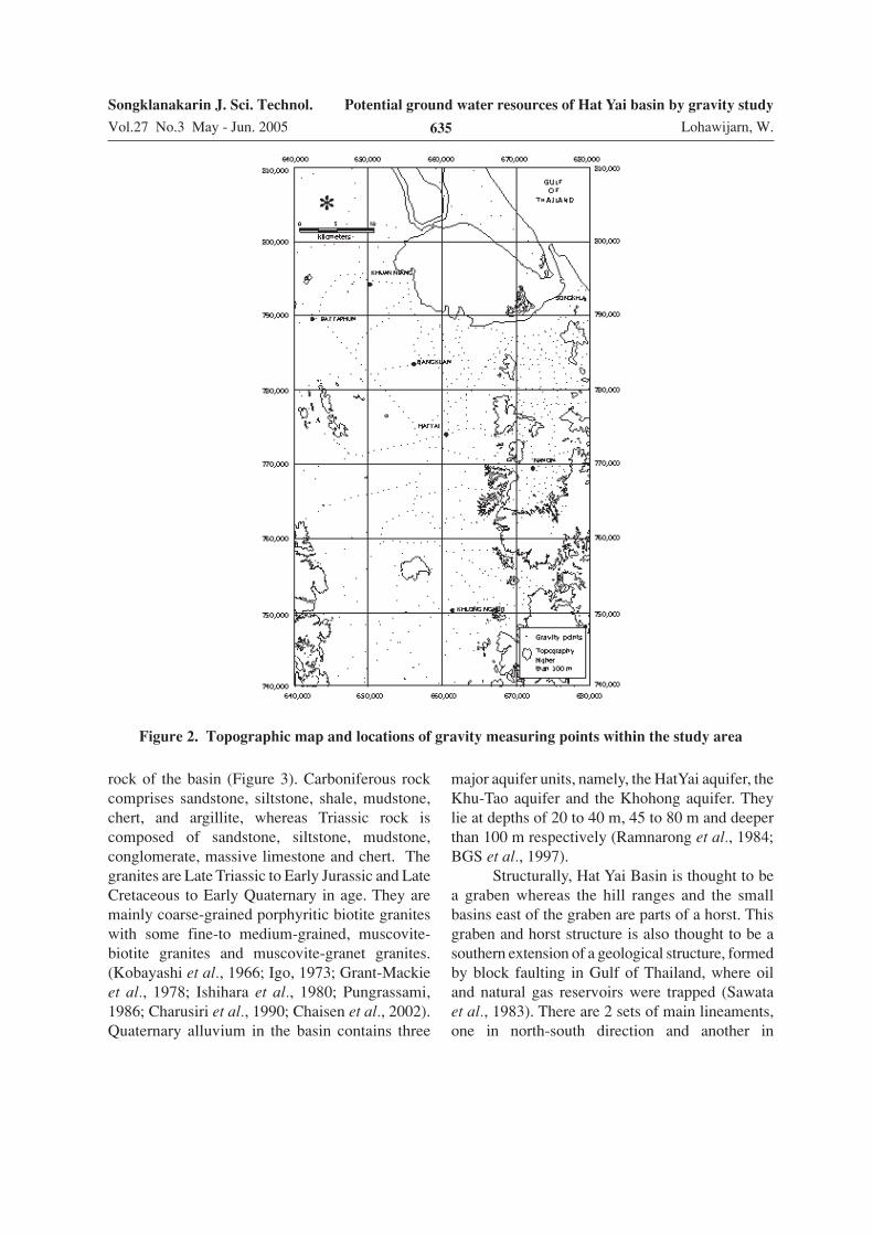
Hat Yai Basin is a sedimentary basin inpeninsular Thailand. It is located approximatelybetween longitudes 100º 15′ E and 100º 30′ E andlatitudes 6º 30′ N and 7º 15′ N (Figure 1).
The study area is topographically a flat areawith an elevation of about 0 to 20 m above meansea level. Its eastern and western rims are boundedby north-south trending mountain ranges. It was
previously thought that Gulf of Thailand and theThailand-Malaysia border respectively (Figure 2)bound the northern and southern boundaries of thebasin.
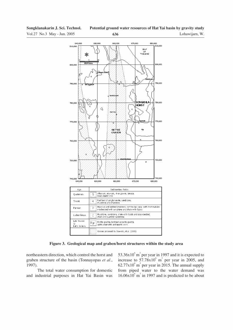
Geologically, Hat Yai Basin is flanked tothe east and west by granitic rocks intruding intoCarboniferous and Triassic sedimentary andmetamorphic rocks, which form the basement
Figure 1. Location of study area
Songklanakarin J. Sci. Technol.
Vol.27 No.3 May - Jun. 2005
Potential ground water resources of Hat Yai basin by gravity study
Lohawijarn, W.635
rock of the basin (Figure 3). Carboniferous rockcomprises sandstone, siltstone, shale, mudstone,chert, and argillite, whereas Triassic rock iscomposed of sandstone, siltstone, mudstone,conglomerate, massive limestone and chert. Thegranites are Late Triassic to Early Jurassic and LateCretaceous to Early Quaternary in age. They aremainly coarse-grained porphyritic biotite graniteswith some fine-to medium-grained, muscovite-biotite granites and muscovite-granet granites.(Kobayashi et al., 1966; Igo, 1973; Grant-Mackieet al., 1978; Ishihara et al., 1980; Pungrassami,1986; Charusiri et al., 1990; Chaisen et al., 2002).Quaternary alluvium in the basin contains three
major aquifer units, namely, the HatYai aquifer, theKhu-Tao aquifer and the Khohong aquifer. Theylie at depths of 20 to 40 m, 45 to 80 m and deeperthan 100 m respectively (Ramnarong et al., 1984;BGS et al., 1997).
Structurally, Hat Yai Basin is thought to bea graben whereas the hill ranges and the smallbasins east of the graben are parts of a horst. Thisgraben and horst structure is also thought to be asouthern extension of a geological structure, formedby block faulting in Gulf of Thailand, where oiland natural gas reservoirs were trapped (Sawataet al., 1983). There are 2 sets of main lineaments,one in north-south direction and another in
Figure 2. Topographic map and locations of gravity measuring points within the study area
Songklanakarin J. Sci. Technol.
Vol.27 No.3 May - Jun. 2005 636
Potential ground water resources of Hat Yai basin by gravity study
Lohawijarn, W.
northeastern direction, which control the horst andgraben structure of the basin (Tonnayopas et al.,1997).
The total water consumption for domesticand industrial purposes in Hat Yai Basin was
53.36x10⁶ m
3 per year in 1997 and it is expected to
increase to 57.78x10⁶ m
3 per year in 2005, and
62.77x10⁶ m
3 per year in 2015. The annual supply
from piped water to the water demand was16.06x10
6 m
3 in 1997 and is predicted to be about
Figure 3. Geological map and graben/horst structures within the study area

Songklanakarin J. Sci. Technol.
Vol.27 No.3 May - Jun. 2005
Potential ground water resources of Hat Yai basin by gravity study
Lohawijarn, W.637
32.12x10⁶ m
3 in 2005 (EMSONG, 1998). A supply
of more than 25.66x10⁶ m
3 per year will certainly
be derived from groundwater. Groundwaterreserve in Hat Yai Basin could be estimated if theboundary of the basin and the porosity of sedimentin the basin are known.
The objectives of the present study weretherefore to delineate a boundary of Hat Yai Basinand to estimate groundwater potential in the basinby gravity study.
There are several successful examples ofbasin boundary mapping in Thailand with gravitymeasurement like Krabi Basin (Markirt et al.,1984 and Rakyao, 1981), Chiang Mai Basin (Beshir,1993) and Sob Prap-Serm Ngam Basin (Thum-vitavas, 1995).
Materials and Methods
The selected study area is a flat area ofapproximately 3200 sq km bounded between UTM640000E and 680000E in east-west direction andbetween UTM 740000N and 810000N in north-south direction.
Altogether 872 gravity points were measuredin the study area. The spacing between gravitypoints laid along available roads and tracks was2 km. However, in some parts of the study area,where detailed information of the basin wasrequired, the spacing between gravity points wasreduced to 1 km.
The gravity measurement was conducted inleapfrog loops with approximately 2 to 2.5 hoursof time spent on each loop. The gravity readingwas carried out with the LaCoste & Romberggravimeter model G. The altitude of each gravitypoint was read from an altimeter, American PaulinSystem MDM-5, whereas the geographic positionsof the points were read with a GPS, TrimblePathfinder Basic Plus. In addition, air temperatureand measuring time were also taken for altitudeand drift corrections.
A benchmark in the Hat Yai campus ofPrince of Songkla University was used as areference point of absolute gravity value in thisstudy. Its UTM coordinates are 660000E and
774637N, or longitude 100º 30′ E and latitude 7º00′ N. The absolute value of gravity and altitudeof this reference point are 9.7812198 m s
-2 and
24.4 m respectively.Standard corrections were applied to the
measured gravity values for drift due to tides andcreeping of gravimeter spring, elevation of themeasuring point, material between measuring pointlevel and sea level and local relief. A terrain densityof 2,500 kg m
-3 (Kaew-On, 1996; Lohawijarn,
1992 and Phethuayluk, 1996) was used in theBouguer correction. The corrected data are Bougueranomalies corrected for material above mean sealevel.
The accuracy of gravity reading was ± 0.1µm s
-2 and that of the geographic position of
measuring points in north-south direction was ± 5m. The difference of the elevation determined bythe altimeter compared with leveling techniquewas ± 7.7 m. This results in overall error in gravityanomaly of about ± 24 µm s
-2.
A contour map of Bouguer anomaly wasconstructed (Figure 4). Since a delineation ofHat Yai Basin is an object of this paper, the lowgravity anomaly caused by Hat Yai Basin will bediscussed in detail. The gravity anomalies of deep-source and surrounding geological bodies werethen considered as regional field. Gravity valuesof some selected points on the gravity map aroundthe low anomaly were picked up as representativesof this regional field and fitted to two-dimensionalpolynomial surfaces of degree 1, degree 2 anddegree 3 to find the best regional field (Figure 5).
Residual gravity anomalies along a hydro-geological profile WW′ (UTM 643352E, 768860Nand UTM 668833E, 777789N, Figure 6) werederived by subtracting from the Bouguer anomalythe regional field of polynomials of differentdegrees along that profile. Cross-sections of thesedimentary basin on that profile were thenmodeled with 2.5 dimensional body, a body ofconstant density with polygonal cross-section anda limited strike length. The density contrast used inthe modeling was -500 kg m
-3, based on difference
in densities of Quaternary sediment and Carboni-ferous rocks.

Songklanakarin J. Sci. Technol.
Vol.27 No.3 May - Jun. 2005 638
Potential ground water resources of Hat Yai basin by gravity study
Lohawijarn, W.
The boundaries of the basin obtained fromthe modeling were then compared with the hydro-geological cross-section and depths of water wells(DMR, 2001) available along the same profileWW′. The modeled parameters which gave thebest agreement for the boundary between themodeled basin and the hydrogeological and waterwells information were used in modeling otherparts of the basin. The parameters are the correctdegree of polynomial function representing regionalgravity field across the basin and the most plausibledensity contrast between basin sediment andbasement rock.
Some residual gravity profiles were takenon each residual anomaly map and Hat Yai Basinwas modeled from these by making use of densitycontrast chosen previously. The location of theseprofiles is already shown in Figure 6. The depthsof the modeled basin were contoured to produce adepth-map. Depths of some water wells availablein the study area were used in verification of thedepth map of Hat Yai Basin in certain locations.It should be noted that the depths of water wellswere depths from mean sea level to the maximumdepth of screening in water wells.
Figure 4. Bouguer anomaly contour in µµµµµm s-2 of the study area.

Songklanakarin J. Sci. Technol.
Vol.27 No.3 May - Jun. 2005
Potential ground water resources of Hat Yai basin by gravity study
Lohawijarn, W.639
Results and Discussion
1. Boundaries of Hat Yai Basin
Alternately high and low anomalies withapproximately north-south trend are clearlyobserved in Figure 4 (distinct high anomaly, "H",between UTM 640000E and 650000E and lowanomalies, "L", between UTM 650000E to665000E and UTM 670000E to 680000E). These
anomalies correspond to the horst/graben structure(Figure 3), which was proposed by Sawata et al.(1983). The low gravity anomaly between UTM650000E to 665000E corresponds with previouslyknown Hat Yai Graben. However, low gravityanomaly was also observed on the proposedSongkhla Horst, east of Hat Yai Graben, whereashigh gravity anomaly was observed on anotherhorst, west of Hat Yai Graben. In addition, it is
Figure 5. Regional anomalies and the corresponding residual anomalies in the study area.
The contours are in µµµµµm s-2 (a) regional anomaly estimated with polynomial surface
of degree 1 and the corresponding residual anomaly (b) regional anomaly
estimated with polynomial surface of degree 2 and the corresponding residual
anomaly (c) regional anomaly estimated with polynomial surface of degree 3 and
the corresponding residual anomaly.

Songklanakarin J. Sci. Technol.
Vol.27 No.3 May - Jun. 2005 640
Potential ground water resources of Hat Yai basin by gravity study
Lohawijarn, W.
likely that low gravity anomaly between UTM650000E to 665000E does not continue northwardinto the Gulf of Thailand or southward to theThailand - Malaysia border as supposed until nowfor Hat Yai Basin.
We are presently interested in determiningthe horizontal boundary and the vertical extensionof the Hat Yai sedimentary basin, which causes thelow gravity anomaly between UTM 650000E to665000E. The western, northern and southernboundaries of the basin are clearly observed on thegravity map at about UTM 650000E, 810000N,and 752000N, respectively. The eastern boundaryof the basin can be placed at the medium gravityvalue ridge, along about 665000E, between the low
gravity anomaly on the Quaternary sediment andthat on the eastern granite pluton.
The regional gravity anomalies and thecorresponding residual anomalies are shown inFigure 5. The negative residual anomalies suggesta low-density sedimentary basin bounded in alldirections. They also show that the southernboundary of the basin is at UTM 750000N, whilethe northern boundary is probably at UTM810000N. Another observation is that the basindoes not lie in a straight NS direction as previouslysupposed but bends eastward at its northern andsouthern ends. This is probably an effect of anortheastern lineament within the basin reportedby Tonnayopas et al. (1997).
Figure 6. Bouguer anomaly contour in µµµµµm s-2 and locations of gravity modeling profiles
within the study area.
Songklanakarin J. Sci. Technol.
Vol.27 No.3 May - Jun. 2005
Potential ground water resources of Hat Yai basin by gravity study
Lohawijarn, W.641
The densities of Quaternary sediment andCarboniferous basement rock are 2000 kg m
-3 and
2520±40 kg m-3 respectively (Kaew-On, 1996;
Lohawijarn, 1992 and Phethuayluk, 1996). How-ever, the density contrast should perhaps berounded off to -500 kg m
-3 to allow for some
increase in density of Quaternary sediment withdepth.
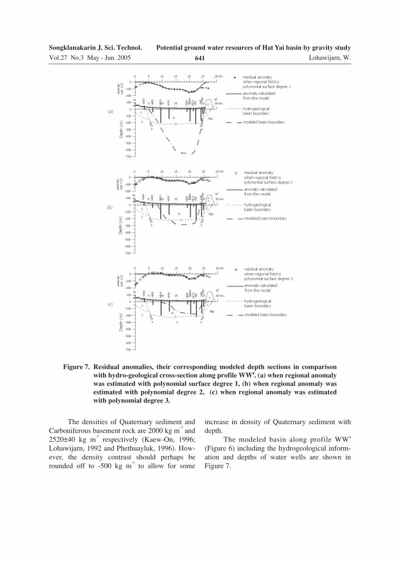
The modeled basin along profile WW′(Figure 6) including the hydrogeological inform-ation and depths of water wells are shown inFigure 7.
Figure 7. Residual anomalies, their corresponding modeled depth sections in comparison
with hydro-geological cross-section along profile WW′′′′′. (a) when regional anomaly
was estimated with polynomial surface degree 1, (b) when regional anomaly was
estimated with polynomial degree 2, (c) when regional anomaly was estimated
with polynomial degree 3.

Songklanakarin J. Sci. Technol.
Vol.27 No.3 May - Jun. 2005 642
Potential ground water resources of Hat Yai basin by gravity study
Lohawijarn, W.
Figure 8. Residual gravity profiles and their corresponding basin model along 8 different
profiles which run across the study area.

Songklanakarin J. Sci. Technol.
Vol.27 No.3 May - Jun. 2005
Potential ground water resources of Hat Yai basin by gravity study
Lohawijarn, W.643
The horizontal boundary of the basinmodeled on residual anomaly derived from regionalanomaly of polynomial degree 1 agrees reasonablywell with that of the hydrogeological boundary.The eastern boundaries of the modeled basin andthe hydrogeological basin are exactly on the sameplace and with similar slope whereas their westernboundaries are about 1 km apart. Disagreementwas observed between water wells H41 and H35where the boundary between the Quaternarysediment and Carboniferous rocks is horizontalwhereas a steep slope appears in the modeledbasin. Since there was only one deep well, H41,that approach the boundary, it is arguable whetherit is really a horizontal boundary or it is just alarge boulder of Carboniferous rock in Quaternary
sediment. The maximum depth of the modeledbasin along profile WW′ is about 650 m belowmean sea level.
The boundary of modeled basin based onthe regional anomaly of polynomial of degree 2does not agree with the hydrogeological boundary.The modeled width is about 6 km less than thewidth of the basin shown on the hydrogeologicalmap, eventhough the west and east slopes of themodeled basin are similar to those of the hydro-geological information. The maximum depth ofthe modeled basin along profile WW′ in this caseis about 300 m below the mean sea level.
Similarly to the above, the boundary of themodeled basin based on the regional anomaly ofpolynomial of degree 3 does not agree with the
Figure 9. Plan view of model for HatYai Basin.

Songklanakarin J. Sci. Technol.
Vol.27 No.3 May - Jun. 2005 644
Potential ground water resources of Hat Yai basin by gravity study
Lohawijarn, W.
Figure 10. Depth contours in meter of HatYai Basin obtained from present study in com-
parison with depth of ground water wells.
hydrogeological boundary. The modeled width isabout 6 km less than the hydrogeological width.In addition the slope on the eastern boundary ofthe modeled basin is gentler than the hydro-geological slope. The maximum depth of the basinis about 200 m below mean sea level in this case.
In summary the polynomial surface ofdegree 1 is considered to best represent the regionalgravity anomaly.
A complete structural model of Hat YaiBasin was obtained by modeling the other 8selected gravity profiles shown in Figure 6 usingresidual gravity anomalies based on a regional
anomaly polynomial surface of degree 1. A densitycontrast of -500 kg m
-3 was employed in the
modeling. The anomalies and cross-sections of thebodies along these profiles are shown in Figure 8.These were calculated using the GMM program ofGeovista AB company, Sweden. The program canhandle upto 20 separate bodies of 2.5D geometry.The basin was modeled with 8 different bodies.The plan view of the model is shown in Figure 9and the cross-section of each body, constant in thenorth-south direction, can be seen in Figure 8 onthe respective profile. All bodies are present incalculating the anomaly on any of the profiles.

Songklanakarin J. Sci. Technol.
Vol.27 No.3 May - Jun. 2005
Potential ground water resources of Hat Yai basin by gravity study
Lohawijarn, W.645
We observe that in the central part of thestudy area, which is covered by profiles AA′, BB′,EE′ and FF′, the depths to the basement of thebasin vary from 650 m to 1000 m. The depthdecreases to about 500 m in the southern part ofthe study area, which is covered by profiles CC′and DD′. The depth to the basement decreases toabout 200 m in the northern part of the study area,which is covered by profiles GG′ and HH′. Theseindicate that the basin has a limited axial lengthof about 60 km in an approximately north-southdirection.
A depth map to Carboniferous basementrock underlying the basin is shown in Figure 10.The positions and depths of water wells are alsoshown in this map. There is good agreementbetween the depth in the depth map and the depthof the water wells within the boundary of thebasin. However, disagreement was observed outsidethe boundary of the basin, e.g. at UTM 650000Eand 800000 and south of UTM 750000E where, inthese areas, the depths of some water wells reach100 m. Since only depths of water wells and notany geological logs of the water wells were avail-able, it is difficult to say whether the depth ofwater wells represents the thickness of Quaternarysediment in the basin. Bottom ends of some wellsmay stay within Quaternary basin while those ofothers may reach Carboniferous basement rock.
2. Estimates of anomalous mass and ground
water potential in Hat Yai Basin
The anomalous mass of sediment in thebasin can be estimated from the surface integrationof residual anomaly by the following relationship:∆M = 2.39 × ∆g∑ ∆s, where M is the anomalousmass in tons if ∆g is in µm s
-2 and s in m
2
(Parasnis, 1997). For this surface integration, thearea of negative anomaly bounded by a contourline of 0 µm s
-2 was divided into a number of
squares of 4 sq km, and the average residualanomaly of each square was determined with anaccuracy of ± 5 µm s
-2. The products of area and
average anomaly of every square when summedup yield 6.80±0.03 x10
10 µm s
-2 m
2. The anomalous
mass of Hat Yai basin is then equal to 16.25±0.07
x1010
tons or 16.25±0.07 x10¹³
kg. This estimateof anomalous mass is independent of any model orany geological assumption.
With the density of the Carboniferous hostrock of 2520 kg m
-3 and of the sediment of 2000
kg m-3, the actual mass of the sediment will be
(2000/520) × (anomalous mass) or 62.5±0.3 x10¹³
kg. The "gravitational" volume of basin sedimentwill then be 31.2±0.2 x10
10 m
3 or 312±2 km
3. The
volume of the sediment can also be evaluated fromthe depth map (Figure 10). Similar to the surfaceintegration of residual anomaly mentioned above,the horizontal area bounded by the basin wasdivided into squares of 4 km
2 each and an averaged
depth of each square was determined with anaccuracy of ±50 m. The products of area andaverage depth of every square were summed upand yielded the "geometrical" volume of the basinsediment of 3.13±0.03 x10
11 m
3, or 313±3 km
3.
There is thus very good agreement between the"gravitational" and geometrical volumes of thebasin.
By assuming the average matrix density of2650 kg m
-3 and fully saturated sediment, the
porosity of the sediment and the overall groundwater reserve in the Hat Yai basin will be approxi-mately 39% and 121.7±0.8 km
3 respectively.
However, the current information of the waterwells showed that water is extracted mainly fromshallow aquifers of less than 80 m deep and muchmore from aquifers of less than 45 m deep. This isbecause deeper aquifers give less yield than theshallow ones (Sakulkeaw, 1996; EMSONG, 1998).The estimated volume of the topmost 80 m groundis 6.4±0.3 x10
10 m
3 or 64±3 km
3. With the same
porosity of 39%, the estimated water reserve willbe 25±1 km
3. The true ground water reserve could
probably be less than half of the above figure, say12.5±0.5 km
3, because impermeable beds of
variable thickness are found interbedding withlayers of aquifer. On the other hand, major normalfaults in Quaternary deposits and older rocks ofthe basin (Tonnayopas et al., 1997) may increaseporosity of formations and aquifer yields. Byconsidering the estimated annual recharge of about33x10
6 to 166x10
6 m
3 (EMSONG, 1998), the travel

Songklanakarin J. Sci. Technol.
Vol.27 No.3 May - Jun. 2005 646
Potential ground water resources of Hat Yai basin by gravity study
Lohawijarn, W.
time of days to weeks and decades for water fromground surface to aquifers at 5 m and 50 m depthrespectively (BGS, 1997), the estimated groundwater reserve is sufficient to meet the expectedwater consumption of the HatYai basin beyond2015.
Conclusion
With gravity measurement, Hat Yai Basinwas found to be about 1 km deep at its deepest,60 km long and 20 km wide. It does not continuesouthward to Malaysia or northward to the Gulf ofThailand as previously suggested by Sawata et al.(1983). The porosity of basin sediment and theamount of potential groundwater reserves withinthe basin are estimated to be 39% and 121.7±0.8km
3 respectively, assuming full saturation.
Acknowledgement
The author would like to thank Faculty ofScience, Prince of Songkla University and theInternational Programme in the Physical Sciences(IPPS) of Uppsala University, Sweden for a grantfor this research work and research equipment.Many thanks are also extended to MineralResources Department for hydrogeological in-formation of the study area. I am indebted toProfessor Emeritus D.S. Parasnis and AssociateProfessor T. Pungrassmi for their valuable scientificdiscussion. Thanks also to Mr Vitchuvalun, MrPhethualuk, Mr Keaw-On and Mr Pompat for theirhelp in the field work.
References
Beshir, J.A. 1993. Gravity and aeromagnetic datainterpretation of Chiang Mai basin, northernThailand. MSc. Thesis. Chiang Mai University.181 p.
BGS, 1997. Assessment of pollution risk to deep groundwaters from urban wastewaters: HatYai CityReport. British Geological Survey TechnicalReport WC/97/16. 51 p.
Chaisen, S., Tonnayopas, D. and Kooptarnond, K. 2002.Quaternary geologic assessment of buildingsand deposits in Songkhla province. Symp. onGeology of Thailand, August 26-31, 2002.Century Park Hotel, Bangkok. p.322-331.
Charusiri, P., Pongsapitch, W. and Kuntapab, C. 1990.Granite belts in Thailand: New evidence 40 Ar/39 Ar. Geology gazette 36(1): 46-62. (in Thai)
DMR, 2001. Groundwater Map of Songkhla Provincein Scale 1:100,000. Bangkok: SEATEC- Ground-water Division, Department of MineralResources.
EMSONG, 1998. Final report on collection and pro-cessing of data for assessment of water use,future water need and water resources avail-ability, The Environmental Management in theSongkhla lake basin. Bangkok: PattanaphumConsultants. 310 p.
Grant-Mackie, J.A., Sawata, H., Arpornsuwan, S.,Arrykul, S., Chutatis, J. and Pungrassami, T.,1978. Triassic strata of southern Thailand.Hat Yai: Geological Research Project, Prince ofSongkla University. Publication No 5, 85p.
Igo, H., 1973. Lower Carboniferous Conodonts fromKo Yo, Songkhla, peninsular Thailand. Geologyand Paleontology of Southeast Asia 12, 29-42.
Ishihara, S., Sawata, H., Shibata, K., Terashima, S.,Arrykul, S. and Sata, K., 1980. Granites andSn-W deposits of peninsular Thailand. MiningGeology, Special Issue 8, 223-241.
Kaew-On, S., 1996. A regional study of geologicalstructure in Changwat Satun and ChangwatSongkhla with geophysical method. MSc Thesis,Prince of Songkla University. 188 p.
Kobayashi, T., Burton, C.K., Tokuyama, A., and Yin,E.H. 1966. The Daonella and Halobia facies ofthe Thai-Malay peninsular compared with thoseof Japan. Geology and Paleontology of South-east Asia 3, 98-122.
Lawrence, A.R., Morris, B.L., Gooddy, D.C., Calow, R.,and Bird, M.J., 1997. The study of the pollutionrisk to deep groundwaters from urban waste-waters: Project Summary Report. BGS TechnicalReport WC/97/15. 44 p.

Songklanakarin J. Sci. Technol.
Vol.27 No.3 May - Jun. 2005
Potential ground water resources of Hat Yai basin by gravity study
Lohawijarn, W.647
Lohawijarn, W., 1992. Regional gravity and auxiliarygeophysical measurements in the Songkhla, Yalaand Pattani Provinces in peninsular Thailandand their geological interpretation. PhD Thesis,Lulea University of Technology. 192 p.
Markirt, T., Laoprapaipan, P., Sanguanlosit, A., Jariya-bhumi, O., and Anupandhanant, P. 1984. Ligniteexploration at Krabi basin. Proceedings of theConference on Applications of Geology and theNational Development. Chulalongkorn Univer-sity, 30-60.
Parasnis, D.S., 1997. Principle of Applied Geophysics,5th ed. London: Chapman & Hall. pp.91-92.
Phethuayluk, S., 1996. A regional study of geologicalstructure in Changwat Songkhla, ChangwatPhattalun and Changwat Trang with geophysicalmethod. MSc Thesis, Prince of Songkla Uni-versity. 170 p.
Pungrassami, T. 1986. Cassiterite and wolframitedeposits in and around the Hat Yai basin,Songkhla province, Thailand. Proceedings of theWorkshop on Economic Geology, Techtonics,Sedimentary Processes and Environment of theQuaternary in Southeast Asia, 135-155.
Rakyao, S. 1981. Lignite exploration with geophysicalmethod. Proceedings of the 1st Conference onMining, Prince of Songkla University, 1-13. (inThai).
Ramnarong, V., Songsawat, S., Sakulkeaw, S. andPhanjasutharot, S. 1984. Hydrological map ofHat Yai basin, Songkhla, Scale 1:50000.Bangkok : Groundwater Division, Departmentof Mineral Resources.
Sakulkeaw, S. 1996. Ground water condition in theHat Yai basin, Songkhla province. Bangkok:Department of Mineral Resources, 176 p. (inThai).
Sawata, H., Wongsomsak, S., Tanchotikul, A.,Dansawasdi, R., Maneeprapun, K. and Muenlek,S. 1983. A hypothetical idea on the formation ofHatYai basin and the Songkhla lagoon. Proceed-ings of the Annual Technical Meeting 1982,Department of Geological Sciences, Chiang MaiUniversity, 109-120.
Suthagorn, P. 1971. Geological survey report of tinmines, Changwat Songkhla. Bangkok: EconomicGeology Division, Department of MineralResources, 25p. (in Thai)
Tonnayopas, D., Rungruang, V. and Kumpeera, A. 1997.Structural and geotechnical investigation ofHat Yai basin by image analysis. Proceedings ofthe Conference on Geophysics in Prospectionfor Natural Resources, Engineering and Environ-mental Problems: Hat Yai, 67-79. (in Thai).
Trangkochasarn, Y. 1980. Geology and mines aroundChangwat Songkhla. Mineral Resource Depart-ment, Regional Office 1, Songkhla. 35p. (in Thai)
Thumvitavas, S., 1995. Geophysical exploration withgravity method in Sop Prab-Serm Ngam basin,Changwat Lumphang. Economic Geology Report21/1993, Department of Mineral Resources,131p. (in Thai).