Possibilities of using historical mining maps in geo-tourism · In our study, we have evaluated the...
10
Acta Geoturistica volume 1 (2010), number 2, 56-65 56 Possibilities of using historical mining maps in geo-tourism PAVEL HRONČEK 1 and KAROL WEIS 2 1 Science and Research Institute Matej Bel University, Research Institute of countries and regions, Cesta na amfiteáter 1, Banská Bystrica 974 01, Slovakia (E-mail: [email protected]) 2 Faculty of Natural Sciences Matej Bel University, Department of geography, geology and landscape ecology, Tajovského 40, Banská Bystrica 974 01, Slovakia (E-mail: [email protected]) ABSTRACT In our study, we have evaluated the possibilities of using historical mining maps and their parergons, which document the mining relicts in the country, in geo-tourism. The historical mining maps and their parergons rank among the oldest and relatively easy-to-access historical picture documents, which provide a true image of a mining landscape. The information-providing value of the maps and the possibility of their analytic use are even more significant after the maps are digitalized and used in multi-layer projections in the GIS environment. Historical mining maps are accurate materials documenting the existence and the development of various montane forms of the relief, subterranean and surface mining areas, quarries, mine dumps, mine pits and placer deposits, the presence of natural and technical systems. They also provide information about technical, service, community and residential buildings, etc. This way, the database of information about landscape forms, particular objects in the country, people and their activities in various time periods, can be developed and subsequently used for the purposes of geo-tourism in a particular region. Key words: historical mining maps, mining landscape, geo-tourism INTRODUCTION Using of historical mining maps and their parergons in geo-tourism has an increasing application now. The historical mining maps and their parergons rank among the oldest and relatively easy-to-access historical picture documents, which provide a true image of a mining landscape. The maps document the particular relicts of a relief as well as the presence of manufacturing-technical and service buildings dated to a certain time period, which corresponds with the time of the map creation. We have examined and compared mining maps from various time periods and were faced with the problem of differences in scales, display systems and cartographic projections as well as differing angles of the view of the landscape. The information- providing value of the maps and the possibility of their analytic use are even more significant after the maps are digitalized and used in multi-layer projections in the GIS environment. HISTORICAL MINING MAPS AND THEIR PARERGONS The oldest mining maps from the territory of Slovakia were drawn in the second half of the 16 th century. Parergons, which illustrate various activities typical for a particular region, technical equipment, architecture or people, began to appear in maps at the beginning of the 17 th century. However, this type of artwork experienced a boom in the 18 th and 19 th centuries. The
Transcript of Possibilities of using historical mining maps in geo-tourism · In our study, we have evaluated the...

Acta Geoturistica volume 1 (2010), number 2, 56-65
56
Possibilities of using historical mining maps in geo-tourism PAVEL HRONČEK
1 and KAROL WEIS2
1Science and Research Institute Matej Bel University, Research Institute of countries and regions, Cesta na amfiteáter 1, Banská Bystrica 974 01, Slovakia (E-mail: [email protected]) 2Faculty of Natural Sciences Matej Bel University, Department of geography, geology and landscape ecology, Tajovského 40, Banská Bystrica 974 01, Slovakia (E-mail: [email protected])
ABSTRACT In our study, we have evaluated the possibilities of using historical mining maps and their parergons, which document the mining relicts in the country, in geo-tourism. The historical mining maps and their parergons rank among the oldest and relatively easy-to-access historical picture documents, which provide a true image of a mining landscape. The information-providing value of the maps and the possibility of their analytic use are even more significant after the maps are digitalized and used in multi-layer projections in the GIS environment. Historical mining maps are accurate materials documenting the existence and the development of various montane forms of the relief, subterranean and surface mining areas, quarries, mine dumps, mine pits and placer deposits, the presence of natural and technical systems. They also provide information about technical, service, community and residential buildings, etc. This way, the database of information about landscape forms, particular objects in the country, people and their activities in various time periods, can be developed and subsequently used for the purposes of geo-tourism in a particular region.
Key words: historical mining maps, mining landscape, geo-tourism
INTRODUCTION Using of historical mining maps and their parergons in geo-tourism has an increasing application now. The historical mining maps and their parergons rank among the oldest and relatively easy-to-access historical picture documents, which provide a true image of a mining landscape. The maps document the particular relicts of a relief as well as the presence of manufacturing-technical and service buildings dated to a certain time period, which corresponds with the time of the map creation. We have examined and compared mining maps from various time periods and were faced with the problem of differences in scales, display systems and cartographic projections as well as differing angles of the
view of the landscape. The information-providing value of the maps and the possibility of their analytic use are even more significant after the maps are digitalized and used in multi-layer projections in the GIS environment.
HISTORICAL MINING MAPS AND THEIR PARERGONS The oldest mining maps from the territory of Slovakia were drawn in the second half of the 16th century. Parergons, which illustrate various activities typical for a particular region, technical equipment, architecture or people, began to appear in maps at the beginning of the 17th century. However, this type of artwork experienced a boom in the 18th and 19th centuries. The

Acta Geoturistica volume 1 (2010), number 2, 56-65
57
largest and richest collections of historical mining maps in Slovakia are deposited in the Central State Mining Archive in Banská Štiavnica. They can be extensively used in the analysis and reconstruction of cultural and natural landscape, too. They document the technical progress, extent and development of mining in particular mining fields. Research of the old mine maps in the historical plane processed J. Vozár (Vozár 1967, 1969, 1969b), J. Bílek (Bílek 1967), a I. Herčko (Herčko 2010). The analyses of old mining maps in terms of anthropogenic geomorphology and mining engineering processed P. Hronček (Hronček 2010a, 2010b). Mapping of mining and mining-technical facilities in the country on old mining maps used of geo-tourizm deal K. Weis and Z. Zupková (Weis, Zupková 2009). The application of old mining maps for purposes of geo-tourism (for example Gelnica and surroundings) processed P. Rybár and L. Hvizdák (Rybár, Hvizdák 2009, 2010). The oldest previously known mine map of the territory of Slovakia mining map of God's gift (Boží Dar) is deposited in the gallery in Jarabá in Low Tatras. The map was drawn in 1569 using a horizontal sundial travel with built-in compass needle. This map is the oldest known well-preserved mining map of the territory of Slovakia. It is deposited in the collections of Hofkammerarchive in Vienna, where it is also the oldest mining map. The map is an interesting sign bearing expressions ,,Creutz Clufft" (lateral vein) and ,,Recht Clufft" (right or main vein). At present modern mining cartography is a commonplace expression. Its introduction to the cartographic practice in the 16th century is a groundbreaking way of understanding of mineral deposits. According to the current knowledge it is the first known case of more precise bearing geological characteristics of old mine maps. Based on this map the course of ore veins from the 16th century in Jarabá can be reconstructed now.
Quality maps of mines appeared in the 17th century. Since the mid-17th century has increasingly faced with data on the progress of mining operations, dealing with mining-geological conditions and other business relationships with mining maps in various mining localities in Slovakia (Vozár 1967, 1969, 1969b). The most valuable fund mapping and planning documentation is the collection of maps and plans of the Main county office which is located in State Mining Archive in Banská Štiavnica. Maps and plans arose of directed activity of the Main County Office in Banská Štiavnica. In total there were preserved 10 701 maps and plans of the years 1841 to 1918 in that fund. The oldest dated mine map of the State Mining Archives in Banská Štiavnica comes from 1641. The vast majority of the maps and plans dates from the 19th century, but 18th century is also represented. The maps relate mainly to the mining region of Banská Štiavnica and the Central Slovakia. A large number of maps refer to the mining localities in eastern Slovakia and also to other mining localities of the former Austro-Hungary (Rakúsko-Uhorsko). All the maps are classified into two bundles inventory. It was necessary to create a map key for the development of modern mining mapping. First "modern" map key intended for mine maps was created by John Möhling in 1793. Map Key was issued as an attachment in the mining geometry book (Anleitung zur Markscheidekunst) during operations in Kremnica (Möhling 1793). The amount of map markers includes point, image and area map markers showing of mining relief, technical building and mining country. They are methodically called image map markers. The key is a processed map marker indicating ore vein, the conduct of underground mining workings, inputs into the mining works - tunnels, mine dumps and the mining pit. Are processed map markers for surface mining buildings, which are technical and administrative

Acta Geoturistica volume 1 (2010), number 2, 56-65
58
nature. They contain the map symbol for Tajch and also modified watercourses. The most of the map marks refers to the landscape elements, land use, relief and communications in the mining country.
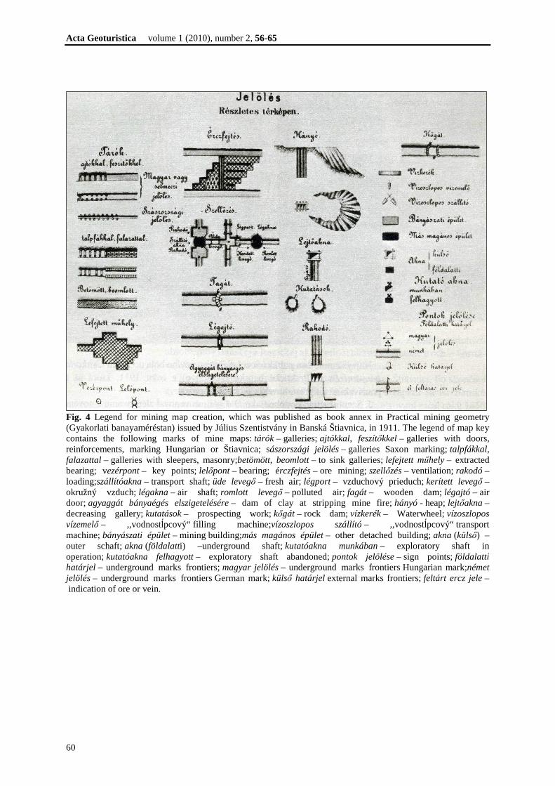
Fig. 1 Title page of mining geometry book: Anleitung zur Markscheidekunst of author J. Möhling published in Vienna in 1793 New map key for mining maps, issued by the professor of Mining and Forestry Academy in Banská Štiavnica Julius Szentistvány in 1911 as book annex in Practical mining geometry (Gyakorlati banayaméréstan, Fig. 4). A legend for mining map creation has the name Sign a detailed ("mine") map (Jelölés – Részletes térképen).
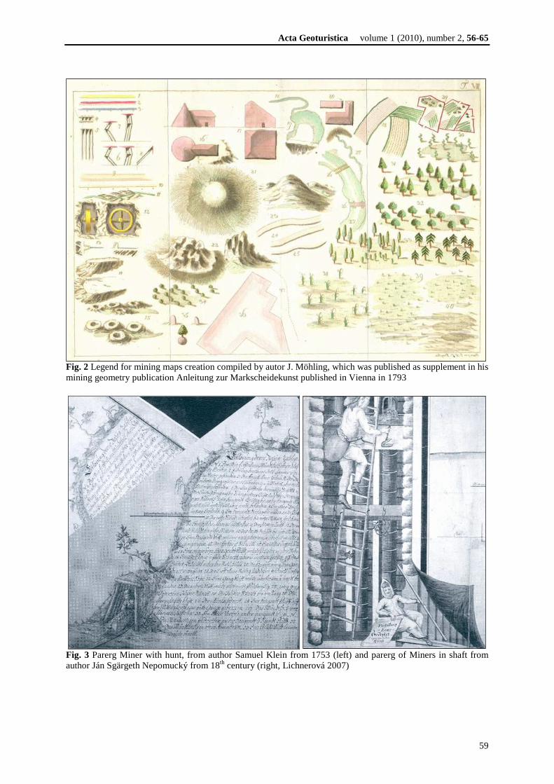
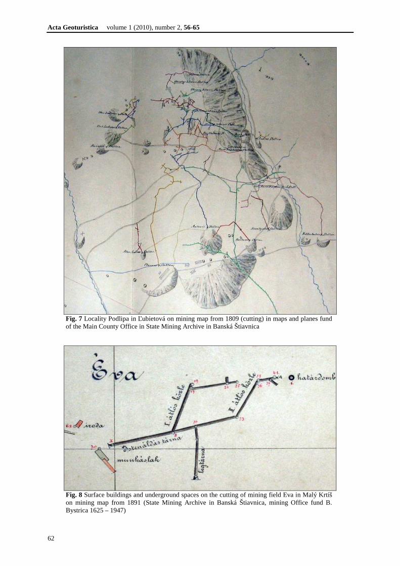
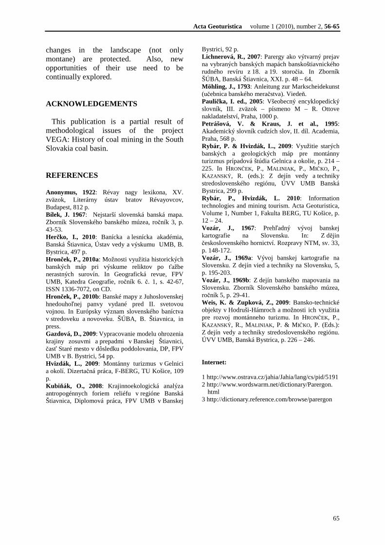
Fig. 3 shows the Parerg Miner with hunt. The word parerga (parergon) comes from the Greek origin, which was accepted by Latin and then transformed into modern languages. Parergu (parergon respectively) is defined as a decoration, decorative element in the corners of old maps and old mining maps (Anonymus 1922, Petrášová, Kraus et al. 1995, Paulička ed. 2005, Lichnerová 2007, www1, www2, www3). The first parergons were created in the beginning of the 17th century. The production of parergons on our territory reached the top of the production in the 18th century. Artistically valuable and quality parergons emerged even in 19th century. Parergons are valuable iconographic material and drawings show various historical mining work and geometry tools, mining and metallurgical facilities, mine and metallurgical period clothing of various professions, mine (galleries, shafts, heaps, mining pit) and similarly. Parergon is a secondary addition of a primarily cartographic work. It is a rich source of information, which can be extensively used mainly in historical research. Therefore, parergons can be directly used in geo-tourism. As an example of mining maps concerning ore mining we are presenting the maps of the ore mining around Ľubietová, where there was mined copper and iron ore. Old mine maps are stored in the fund of maps and plans of the Main County Office in State Mining Archive in Banská Štiavnica. Mining maps locality Podlipa are from 1740 and from 1809 are included in the paper cutouts. The maps contain mine tunnels, shafts and heap and the original mining building. As an example, mine maps for lignite mining are used examples of the the South Slovakia coal basin. These maps are stored in the mining Office fund B. Bystrica by 1625 to 1947. We present the cutting of mining maps from surroundings Malé Zlievce (mining field Jozef) and Malý Krtíš (mining field Eva).
Acta Geoturistica volume 1 (2010), number 2, 56-65
59
Fig. 2 Legend for mining maps creation compiled by autor J. Möhling, which was published as supplement in his mining geometry publication Anleitung zur Markscheidekunst published in Vienna in 1793
Fig. 3 Parerg Miner with hunt, from author Samuel Klein from 1753 (left) and parerg of Miners in shaft from author Ján Sgärgeth Nepomucký from 18th century (right, Lichnerová 2007)
Acta Geoturistica volume 1 (2010), number 2, 56-65
60
Fig. 4 Legend for mining map creation, which was published as book annex in Practical mining geometry (Gyakorlati banayaméréstan) issued by Július Szentistvány in Banská Štiavnica, in 1911. The legend of map key contains the following marks of mine maps: tárók – galleries; ajtókkal, feszítőkkel – galleries with doors, reinforcements, marking Hungarian or Štiavnica; sászországi jelölés – galleries Saxon marking; talpfákkal, falazattal – galleries with sleepers, masonry;betömött, beomlott – to sink galleries; lefejtett műhely – extracted bearing; vezérpont – key points; lelőpont – bearing; érczfejtés – ore mining; szellőzés – ventilation; rakodó – loading;szállítóakna – transport shaft; üde levegő – fresh air; légport – vzduchový prieduch; kerített levegő – okružný vzduch; légakna – air shaft; romlott levegő – polluted air; fagát – wooden dam; légajtó – air door; agyaggát bányaégés elszigetelésére – dam of clay at stripping mine fire; hányó - heap; lejtőakna – decreasing gallery; kutatások – prospecting work; kőgát – rock dam; vízkerék – Waterwheel; vízoszlopos vízemelő – ,,vodnostĺpcový“ filling machine;vízoszlopos szállító – ,,vodnostĺpcový“ transport machine; bányászati épület – mining building;más magános épület – other detached building; akna (külső) – outer schaft; akna (földalatti) –underground shaft; kutatóakna munkában – exploratory shaft in operation; kutatóakna felhagyott – exploratory shaft abandoned; pontok jelölése – sign points; földalatti határjel – underground marks frontiers; magyar jelölés – underground marks frontiers Hungarian mark;német jelölés – underground marks frontiers German mark; külső határjel external marks frontiers; feltárt ercz jele – indication of ore or vein.

Acta Geoturistica volume 1 (2010), number 2, 56-65
61
Fig. 5 Cutting of mining map of Podlipa locality from 1740 in maps and planes fund of Main County Office in State Mining Archive in Banská Štiavnica
Fig. 6 Mining map of the mine field Jozef in Malé Zlievce from 1861 (State Mining Archive in Banská Štiavnica, mining Office fund B. Bystrica 1625 – 1947)
Acta Geoturistica volume 1 (2010), number 2, 56-65
62
Fig. 7 Locality Podlipa in Ľubietová on mining map from 1809 (cutting) in maps and planes fund of the Main County Office in State Mining Archive in Banská Štiavnica
Fig. 8 Surface buildings and underground spaces on the cutting of mining field Eva in Malý Krtíš on mining map from 1891 (State Mining Archive in Banská Štiavnica, mining Office fund B. Bystrica 1625 – 1947)

Acta Geoturistica volume 1 (2010), number 2, 56-65
63
USING HISTORICAL MINING MAPS IN GEO-TOURISM Historical mining maps are accurate materials documenting the existence and development of various montaneous forms of the relief, subterranean and surface mining areas, quarries, mine dumps, mine pits and placer deposits, the presence of natural and technical systems, they also provide information about technical, service community and residential buildings, etc. The results of the maps content analysis can, therefore, serve as a primary stimulus for detailed field and archive researches. This way, the database of information about landscape forms, particular objects in the country, people and their activities in various time periods can be developed and subsequently used for the purposes of geo-tourism in a particular region. An example of the use of historical mining maps is making graphic materials appropriate for the presentation of specific types of mining and technical objects. They are essential for documenting the development of montaneous landforms. They are also used for purposes geo-tourism information panels and accompanying texts. One of the applications processing of old
mine maps is the visualization of underground workings in geo-tourism more usable and more easily conceivable form. Creating 3D models of mining works and their presentation is very attractive tourist point of view (Fig. 9). Based on the processing of mining maps and plans are upgraded bottoms profiles of selected Banská Štiavnica dams as technical objects. Are modeled changes of retention volumes as a result of accumulation of alluvial sediments for very long periods (more than 100 years, Fig. 10). Historic mine maps were used in the analysis changes of montan relief and for modeling of changes in landscape-ecological indicators after anthropogenic transformations relief. An example of such use is from lokality Štiavnické Bane, part Horná Roven (Fig. 11). The synthesis of this set of information is followed by finding an appropriate form of their presentation, which depends on the technical skills of the authors. The presentation needs to comply with the geo-tourism clients’ expectations, which should get reflected in the complex geo-tourism product. This product shall contain a set of micro-products, i.e. various tourism attractions, including optimized educational trails. One of the goals is to combine the
Fig. 9 Mine Laurenti (left), view from above – Krížová tunnel and Hoffnungsschager shaft (Hvizdák, 2009), mining horizons accessible with Michal shaft, Hoffnungsschager shaft (right) – Banská Štiavnica (Gazdová, 2009)

Acta Geoturistica volume 1 (2010), number 2, 56-65
64
Fig. 10 Territory model befallen with anthropogenically influenced erosion and sequent sedimentation in water pond, therefore accumulation of sediments caused decrease of water pond retention about 35 000 m3 in period of 100 years (Kubinský 2010)
Fig. 11 Digital model of relief before and after modelation of surface mining. Typical historical mining landscape with large compensation dump, pings, tunnels and waste piles after lapsed shafts (Kubiňák, 2008) tourism micro-products into selectable packages according to various criteria, for example, trail accessibility, content of presentation, time, trail difficulty, price, or other clients’ requirements. It is important that the used equipment is on a high technical level. In addition, the client should be able to enjoy other high-quality services, such as lodging, access to Internet, wellness, facilities for active relaxation, etc. By applying various criteria, the clients will be given an opportunity to use diversified offers, which include micro-products varying in content, form and focus, all this
within a minimal (easy-to-access) area or along a certain hiking-informational trail. Thematically planed trails are an option, too. The original historical mining maps are cartographic works often of a very high technical and artistic quality. It is not only the content and reason of their creation, which are important in searching for ways of their use; moreover, the maps are testimonies of the authors, of their technical skills and sensitivity. Therefore, it is important to assure that the artefacts, which show and reflect, in a number of ways, the
Acta Geoturistica volume 1 (2010), number 2, 56-65
65
changes in the landscape (not only montane) are protected. Also, new opportunities of their use need to be continually explored. ACKNOWLEDGEMENTS This publication is a partial result of methodological issues of the project VEGA: History of coal mining in the South Slovakia coal basin. REFERENCES Anonymus, 1922: Révay nagy lexikona, XV. zväzok, Literárny ústav bratov Révayovcov, Budapest, 812 p. Bílek, J. 1967: Nejstarší slovenská banská mapa. Zborník Slovenského banského múzea, ročník 3, p. 43-53. Herčko, I., 2010: Banícka a lesnícka akadémia, Banská Štiavnica, Ústav vedy a výskumu UMB, B. Bystrica, 497 p. Hronček, P., 2010a: Možnosti využitia historických banských máp pri výskume reliktov po ťažbe nerastných surovín. In Geografická revue, FPV UMB, Katedra Geografie, ročník 6. č. 1, s. 42-67, ISSN 1336-7072, on CD. Hronček, P., 2010b: Banské mapy z Juhoslovenskej hnedouhoľnej panvy vydané pred II. svetovou vojnou. In Európsky význam slovenského baníctva v stredoveku a novoveku. ŠÚBA, B. Štiavnica, in press. Gazdová, D., 2009: Vypracovanie modelu ohrozenia krajiny zosuvmi a prepadmi v Banskej Štiavnici, časť Staré mesto v dôsledku poddolovania, DP, FPV UMB v B. Bystrici, 54 pp. Hvizdák, L., 2009: Montánny turizmus v Gelnici a okolí. Dizertačná práca, F-BERG, TU Košice, 109 p. Kubiňák, O., 2008: Krajinnoekologická analýza antropogénnych foriem reliéfu v regióne Banská Štiavnica, Diplomová práca, FPV UMB v Banskej
Bystrici, 92 p. Lichnerová, R., 2007: Parergy ako výtvarný prejav na vybraných banských mapách banskoštiavnického rudného revíru z 18. a 19. storočia. In Zborník ŠÚBA, Banská Štiavnica, XXI. p. 48 – 64. Möhling, J., 1793: Anleitung zur Markscheidekunst (učebnica banského meračstva). Viedeň. Paulička, I. ed., 2005: Všeobecný encyklopedický slovník, III. zväzok – písmeno M – R. Ottove nakladatelství, Praha, 1000 p. Petrášová, V. & Kraus, J. et al., 1995: Akademický slovník cudzích slov, II. díl. Academia, Praha, 568 p. Rybár, P. & Hvizdák, L., 2009: Využitie starých banských a geologických máp pre montánny turizmus prípadová štúdia Gelnica a okolie, p. 214 – 225. In HRONČEK, P., MALINIAK , P., M IČKO, P., KAZANSKÝ , R. (eds.): Z dejín vedy a techniky stredoslovenského regiónu, ÚVV UMB Banská Bystrica, 299 p. Rybár, P., Hvizdák, L. 2010: Information technologies and mining tourism. Acta Geoturistica, Volume 1, Number 1, Fakulta BERG, TU Košice, p. 12 – 24. Vozár, J., 1967: Prehľadný vývoj banskej kartografie na Slovensku. In: Z dějin československého hornictví. Rozpravy NTM, sv. 33, p. 148-172. Vozár, J., 1969a: Vývoj banskej kartografie na Slovensku. Z dejín vied a techniky na Slovensku, 5, p. 195-203. Vozár, J., 1969b: Z dejín banského mapovania na Slovensku. Zborník Slovenského banského múzea, ročník 5, p. 29-41. Weis, K. & Zupková, Z., 2009: Bansko-technické objekty v Hodruši-Hámroch a možnosti ich využitia pre rozvoj montánneho turizmu. In HRONČEK, P., KAZANSKÝ , R., MALINIAK , P. & M IČKO, P. (Eds.): Z dejín vedy a techniky stredoslovenského regiónu. ÚVV UMB, Banská Bystrica, p. 226 – 246. Internet: 1 http://www.ostrava.cz/jahia/Jahia/lang/cs/pid/5191 2 http://www.wordswarm.net/dictionary/Parergon.
html 3 http://dictionary.reference.com/browse/parergon