poso creek IRWMP brochure v2 - Semitropic Water … IRWMP/Poso Creek IRWMP Bro… · —Adopted...
8
—Adopted July 2007— Integrated Regional Water Management Plan Poso Creek
Transcript of poso creek IRWMP brochure v2 - Semitropic Water … IRWMP/Poso Creek IRWMP Bro… · —Adopted...
—Adopted July 2007—
Integrated Regional Water Management PlanPoso Creek
| 2 |
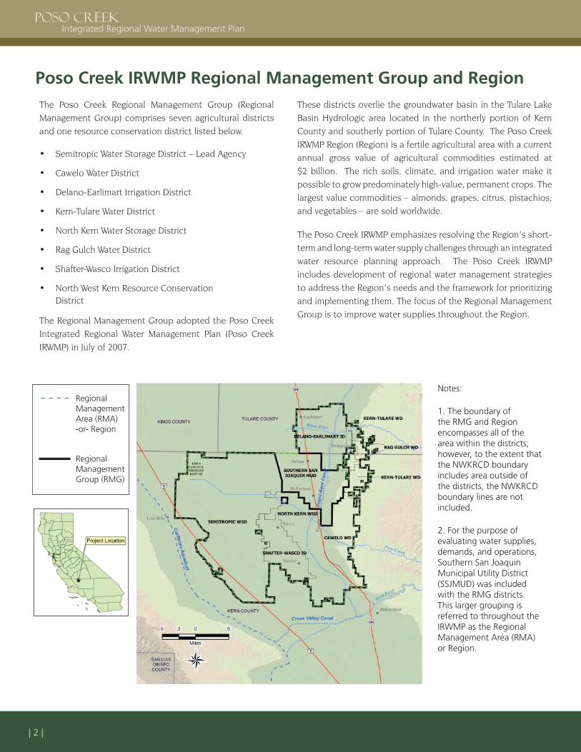
Poso Creek IRWMP Regional Management Group and RegionThe Poso Creek Regional Management Group (Regional Management Group) comprises seven agricultural districts and one resource conservation district listed below.
Semitropic Water Storage District – Lead Agency
Cawelo Water District
Delano-Earlimart Irrigation District
Kern-Tulare Water District
North Kern Water Storage District
Rag Gulch Water District
Shafter-Wasco Irrigation District
North West Kern Resource Conservation District
The Regional Management Group adopted the Poso Creek Integrated Regional Water Management Plan (Poso Creek IRWMP) in July of 2007.
•
•
•
•
•
•
•
•
These districts overlie the groundwater basin in the Tulare Lake Basin Hydrologic area located in the northerly portion of Kern County and southerly portion of Tulare County. The Poso Creek IRWMP Region (Region) is a fertile agricultural area with a current annual gross value of agricultural commodities estimated at $2 billion. The rich soils, climate, and irrigation water make it possible to grow predominately high-value, permanent crops. The largest value commodities – almonds, grapes, citrus, pistachios, and vegetables – are sold worldwide.
The Poso Creek IRWMP emphasizes resolving the Region’s short-term and long-term water supply challenges through an integrated water resource planning approach. The Poso Creek IRWMP includes development of regional water management strategies to address the Region’s needs and the framework for prioritizing and implementing them. The focus of the Regional Management Group is to improve water supplies throughout the Region.
Notes:
1. The boundary of the RMG and Region encompasses all of the area within the districts; however, to the extent that the NWKRCD boundary includes area outside of the districts, the NWKRCD boundary lines are not included.
2. For the purpose of evaluating water supplies, demands, and operations, Southern San Joaquin Municipal Utility District (SSJMUD) was included with the RMG districts. This larger grouping is referred to throughout the IRWMP as the Regional Management Area (RMA) or Region.
Regional Management Area (RMA) -or- Region
Regional Management Group (RMG)
| 3 |
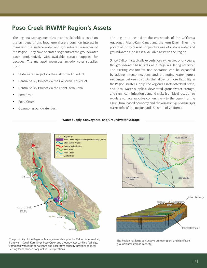
The Regional Management Group and stakeholders (listed on the last page of this brochure) share a common interest in managing the surface water and groundwater resources of the Region. They have operated segments of the groundwater basin conjunctively with available surface supplies for decades. The managed resources include water supplies from:
State Water Project via the California Aqueduct
Central Valley Project via the California Aqueduct
Central Valley Project via the Friant-Kern Canal
Kern River
Poso Creek
Common groundwater basin
•
•
•
•
•
•
The Region is located at the crossroads of the California Aqueduct, Friant-Kern Canal, and the Kern River. Thus, the potential for increased conjunctive use of surface water and groundwater supplies is a valuable asset to the Region.
Since California typically experiences either wet or dry years, the groundwater basin acts as a large regulating reservoir. The existing conjunctive use operation can be expanded by adding interconnections and promoting water supply exchanges between districts that allow for more flexibility in the Region’s water supply. The Region’s assets of federal, state, and local water supplies, dewatered groundwater storage, and significant irrigation demand make it an ideal location to regulate surface supplies conjunctively to the benefit of the agricultural based economy and the economically-disadvantaged communities of the Region and the state of California.
Poso Creek IRWMP Region’s Assets
Water Supply, Conveyance, and Groundwater Storage
The Region has large conjunctive use operations and signifi cant groundwater storage capacity.
Poso Creek RMG
Friant-Kern
Canal
Direct Recharge
Indirect Recharge
The proximity of the Regional Management Group to the California Aqueduct, Fiant-Kern Canal, Kern River, Poso Creek and groundwater banking facilities, combined with large conveyance and absorptive capacity, provides an ideal setting for expanded conjunctive use operations.
| 4 |
The accumulated effect of surface water supplies is reflected in the Region’s groundwater levels. As shown in the figure below, surface water supplies to the Region have generally stabilized groundwater levels since 1970. This relatively balanced condition would continue if deliveries of surface water supplies were to remain the same as recent historical amounts. However, the Region’s deliveries of surface water supplies are projected to decrease due to increased urbanization and environmental uses throughout the state.
Also shown illustratively in the figure are the effects of the projected reduction in deliveries of surface water supplies on regional groundwater levels. As pressure on surface supplies increases, it is apparent that the Region must make additional
Challenges to the Region
1950 20262006YEARS
Historical Future
Regional Groundwater Levels
With projected reduction
in surface water supplies
With Poso Creek IRWMP
The Largest Water Supply Challenges Facing the Region
Water Reliability
Water Cost
Water Quality
•
•
•
use of its groundwater basin to regulate and absorb the available wet-year supplies. This increased conjunctive use operation will help maintain water reliability within the Region.
Since the Region produces crops for both local and world markets, to maintain its competitive role in the market place, the water supply must remain economical. Increased conjunctive use operations will help to maintain or enhance groundwater levels that support economically viable groundwater pumping lifts.
Groundwater quality in the Region is currently very good. Water banking and exchange activities will require water quality management and treatment to maintain that water quality.
WA
TER
LEV
ELS
1970
| 5 |
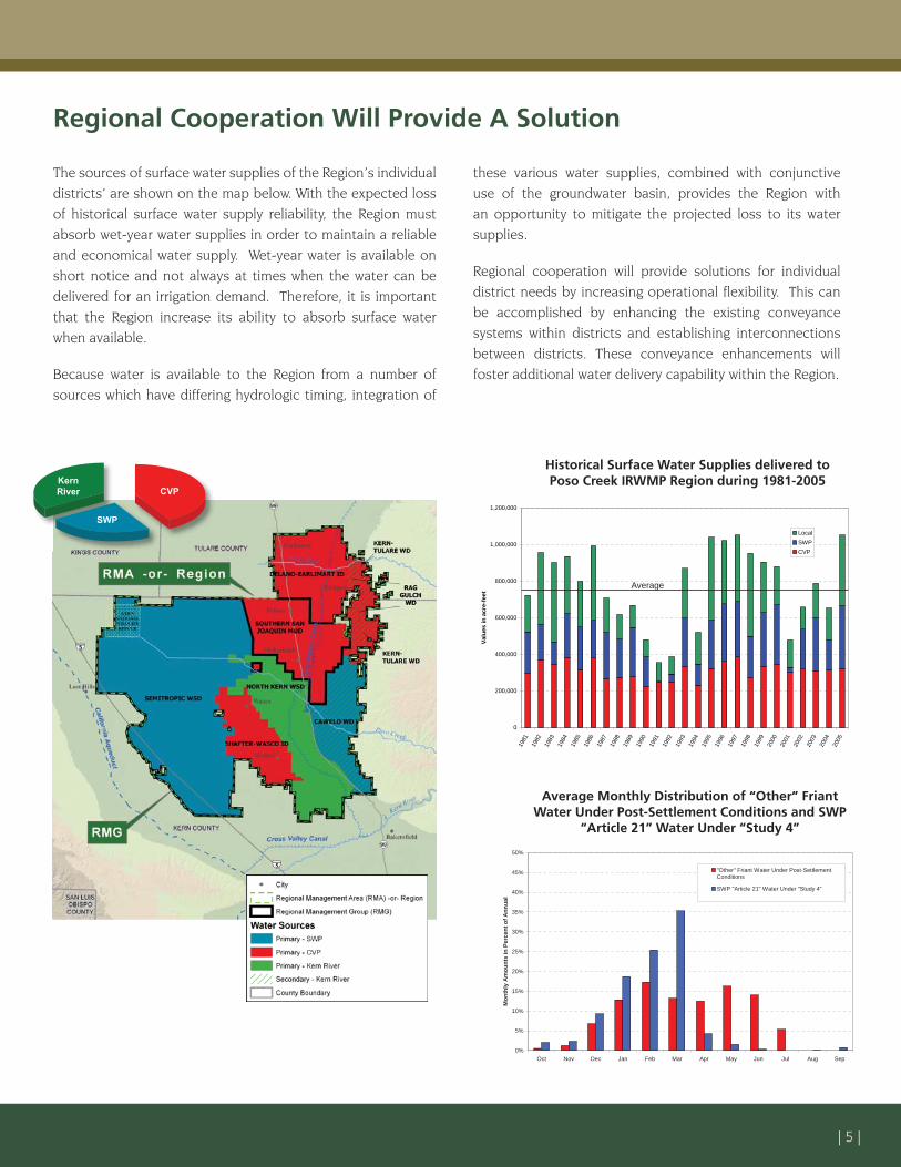
The sources of surface water supplies of the Region’s individual districts’ are shown on the map below. With the expected loss of historical surface water supply reliability, the Region must absorb wet-year water supplies in order to maintain a reliable and economical water supply. Wet-year water is available on short notice and not always at times when the water can be delivered for an irrigation demand. Therefore, it is important that the Region increase its ability to absorb surface water when available.
Because water is available to the Region from a number of sources which have differing hydrologic timing, integration of
Average Monthly Distribution of “Other” Friant Water Under Post-Settlement Conditions and SWP
“Article 21” Water Under “Study 4”
Regional Cooperation Will Provide A Solution
these various water supplies, combined with conjunctive use of the groundwater basin, provides the Region with an opportunity to mitigate the projected loss to its water supplies.
Regional cooperation will provide solutions for individual district needs by increasing operational flexibility. This can be accomplished by enhancing the existing conveyance systems within districts and establishing interconnections between districts. These conveyance enhancements will foster additional water delivery capability within the Region.
0
200,000
400,000
600,000
800,000
1,000,000
1,200,000
1981
1982
1983
1984
1985
1986
1987
1988
1989
1990
1991
1992
1993
1994
1995
1996
1997
1998
1999
2000
2001
2002
2003
2004
2005
Valu
es in
acr
e-fe
et
LocalSWPCVP
KernRiver CVP
SWP
Historical Surface Water Supplies delivered to Poso Creek IRWMP Region during 1981-2005
0%
5%
10%
15%
20%
25%
30%
35%
40%
45%
50%
Oct Nov Dec Jan Feb Mar Apr May Jun Jul Aug Sep
Mon
thly
Am
ount
s in
Per
cent
of A
nnua
l
"Other" Friant Water Under Post-SettlementConditions
SWP "Article 21" Water Under "Study 4"
Average
| 6 |
Planning Objectives, Strategies and Water Management Measures
The RMG intends to implement non-structural and structural water resource management measures that support the Region’s Planning Objectives and consider the State of California’s state-wide priorities and the California Water Plan Update 2005 Resource Management Strategies.
The seven Planning Objectives which were identified for the Region are listed below. The more detailed operational objectives developed by the RMG during the plan formulation are included in Table ES-1 of the Plan.
1) Maintain and improve water supply reliability
2) Maintain groundwater levels at economically viable pumping lifts
3) Protect the quality of groundwater and enhance where practical
4) Maintain water supply costs at a level commensurate with the continued viability of the agricultural economy which has developed in the area
5) Enhance monitoring activities to meet groundwater levels and water quality goals
6) Maintain and/or enhance environmental resources within and outside of the study area
7) Enhance flood control in the study area
Planning objectives 1 through 5 were selected by the Regional Management Group based on a consensus reached during a pre-application meeting held on April 20, 2005. Subsequently, during the kick-off meeting for the Poso Creek IRWMP held on January 5, 2006, the Regional Management Group added planning objective 6, and, based on stakeholder input during monthly meetings held in 2006, planning objective 7 was added.
The Regional Management Group, with input from the stakeholders, has considered all of the Water Management Strategies listed in Table 2– Water Management Strategies of the IRWM Grant Program Guidelines. Most of these water management strategies are already practiced in this Region to some extent, as discussed in Chapter 6 of this Plan. Due to the overwhelming need to address water supply issues within the Region, the RMG prioritized water management strategies into the following two groups;
Highest Priority Strategies Considered for Project ImplementationGroundwater managementWater supply reliabilityConjunctive management of surface water and groundwaterWater transfers and exchangesWater quality protection and improvement
Strategies Considered for Project Integration1
Ecosystem restorationEnvironmental and habitat protection and improvementFlood managementImported waterLand use planningNPS pollution controlRecreation and public accessStorm water capture and managementSurface storageWater conservationWater recyclingWater and wastewater treatmentWatershed planningWetlands enhancement and creation
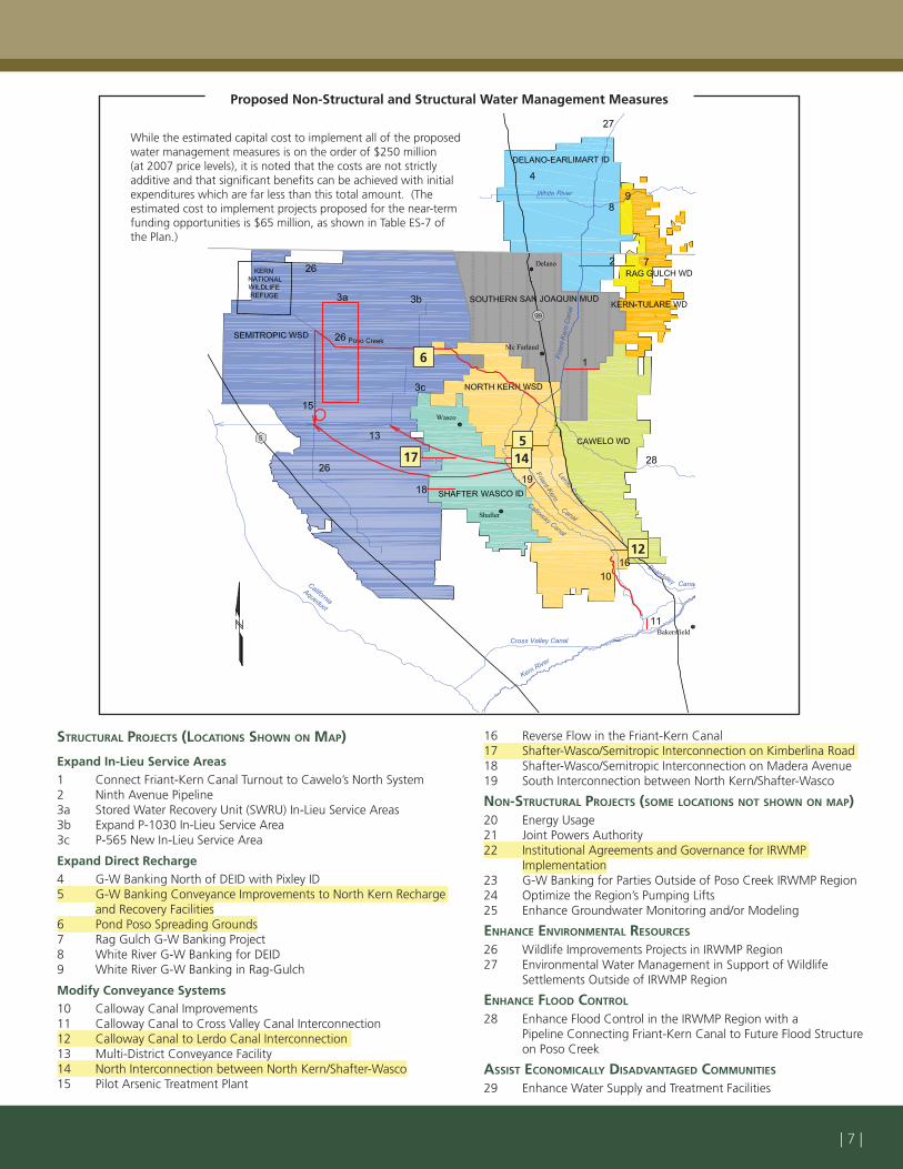
The Regional Management Group formulated and prioritized projects to implement, consisting of the non-structural and structural water management measures listed on the opposite page. Locations of the proposed structural measures are shown on the map. The projects that are proposed for near-term funding proposals are highlighted. Implementation of these projects will occur in phases as funding opportunities are secured to match local contributions.
•••
••
••••••••••••••
1 Due to the location of the Region, desalination is the only water management strategy not under consideration for the Region.
As Projects are implemented to meet the highest priorities for the Region, secondary benefi ts that each project may provide will be integrated into the regional solution. These benefi ts may include, fl ood control, ecosystem restoration, environmental and habitat protection and improvement, reduction in use of power and energy, water quality improvements, subsidence mitigation, and many others.
| 7 |
Proposed Non-Structural and Structural Water Management Measures
STRUCTURAL PROJECTS (LOCATIONS SHOWN ON MAP)
Expand In-Lieu Service Areas1 Connect Friant-Kern Canal Turnout to Cawelo’s North System 2 Ninth Avenue Pipeline3a Stored Water Recovery Unit (SWRU) In-Lieu Service Areas 3b Expand P-1030 In-Lieu Service Area 3c P-565 New In-Lieu Service Area
Expand Direct Recharge4 G-W Banking North of DEID with Pixley ID5 G-W Banking Conveyance Improvements to North Kern Recharge
and Recovery Facilities6 Pond Poso Spreading Grounds7 Rag Gulch G-W Banking Project 8 White River G-W Banking for DEID9 White River G-W Banking in Rag-Gulch
Modify Conveyance Systems10 Calloway Canal Improvements 11 Calloway Canal to Cross Valley Canal Interconnection12 Calloway Canal to Lerdo Canal Interconnection 13 Multi-District Conveyance Facility14 North Interconnection between North Kern/Shafter-Wasco15 Pilot Arsenic Treatment Plant
16 Reverse Flow in the Friant-Kern Canal 17 Shafter-Wasco/Semitropic Interconnection on Kimberlina Road 18 Shafter-Wasco/Semitropic Interconnection on Madera Avenue 19 South Interconnection between North Kern/Shafter-Wasco
NON-STRUCTURAL PROJECTS (SOME LOCATIONS NOT SHOWN ON MAP)20 Energy Usage21 Joint Powers Authority22 Institutional Agreements and Governance for IRWMP
Implementation23 G-W Banking for Parties Outside of Poso Creek IRWMP Region24 Optimize the Region’s Pumping Lifts25 Enhance Groundwater Monitoring and/or Modeling
ENHANCE ENVIRONMENTAL RESOURCES
26 Wildlife Improvements Projects in IRWMP Region27 Environmental Water Management in Support of Wildlife
Settlements Outside of IRWMP Region
ENHANCE FLOOD CONTROL
28 Enhance Flood Control in the IRWMP Region with a Pipeline Connecting Friant-Kern Canal to Future Flood Structure
on Poso Creek
ASSIST ECONOMICALLY DISADVANTAGED COMMUNITIES
29 Enhance Water Supply and Treatment Facilities
6
5
12
1417
While the estimated capital cost to implement all of the proposed water management measures is on the order of $250 million (at 2007 price levels), it is noted that the costs are not strictly additive and that signifi cant benefi ts can be achieved with initial expenditures which are far less than this total amount. (The estimated cost to implement projects proposed for the near-term funding opportunities is $65 million, as shown in Table ES-7 of the Plan.)
| 8 |
Wilmar L. Boschman General ManagerSemitropic Water Storage District
David R. Ansolabehere General ManagerCawelo Water District
Dale R. Brogan General ManagerDelano-Earlimart Irrigation District
Steven C. Dalke General ManagerKern-Tulare Water District
Your interest in the Region’s water resources and views on how they should be managed are important to the Regional Management Group and stakeholders. We welcome your input, reviews, and comments on the Poso Creek IRWMP. The Regional Management Group will continue to meet monthly as part of implementing the plan. Regional Management Group public meetings are typically held at 12 pm on the first Tuesday of each month at the Semitropic Water Storage District offices. You may also participate in the meetings by conference call.
Please contact Mr. Paul Oshel, District Engineer for Semitropic Water Storage District, at (661) 758-5113, for information or to answer questions on behalf of the following eight entities:
Dana S. Munn Engineer-ManagerNorth Kern Water Storage District
Brian HockettDistrict ManagerNorth West Kern Resource Conservation District (NWKRCD)
Steven C. Dalke General ManagerRag Gulch Water District
Jerry L. Ezell General ManagerShafter-Wasco Irrigation District
Funding assistance for the Poso Creek Integrated Regional Water Management Plan was provided by the California Department of Water Resources through a Proposition 50 planning grant.
State and Federal Agencies
California Department of Fish and GameCalifornia Department of Water ResourcesU.S. Bureau of Reclamation
Legislative Contacts
Congressman Kevin McCarthyCongressman Jim CostaCongressman Devin NunesSenator Dean Florez Senator Roy AshburnAssembly Member Nicole ParraAssembly Member Jean FullerAssemblyman Bill Maze
•••
••••••••
Regional Stakeholders
Buena Vista Water Storage DistrictLost Hills Water DistrictRosedale-Rio Bravo Water Storage DistrictSouthern San Joaquin Municipal Utility DistrictKern County Water Agency Friant Water Users AuthorityKern County Board of SupervisorsCity of DelanoCity of McFarlandCity of ShafterCity of WascoLost Hills Utility DistrictKern National Wildlife Refuge
•••••••••••••
Prepared by: