Position, Navigation, and Timing Branch C2D, Battle ... · PDF filePosition, Navigation, and...
21
Soldier Navigation Architecture Study Presented by Van Tran / Gina Guiducci August 3, 2009 Position, Navigation, and Timing Branch C2D, Battle Command Division Fort Monmouth, NJ Approved for Public Release, Distribution Unlimited
Transcript of Position, Navigation, and Timing Branch C2D, Battle ... · PDF filePosition, Navigation, and...
Soldier Navigation Architecture Study
Presented by Van Tran / Gina Guiducci
August 3, 2009
Position, Navigation, and Timing BranchC2D, Battle Command DivisionFort Monmouth, NJ
Approved for Public Release, Distribution Unlimited

Who We Are
Department of Defense (DoD)
Department of the Army (DA)
Army Materiel Command (AMC)
Research, Development and Engineering Command (RDECOM)
Communications-Electronics Research, Development and Engineering Center (CERDEC)
Command and Control Directorate (C2D)
Approved for Public Release, Distribution Unlimited

Introduction
• The Army has a growing need to conduct operations in urban and indoor environments.
• The Communications Electronic Research, Development and Engineering Center's (CERDEC) Command and Control Directorate (C2D) is pursuing several programs to develop positioning capabilities for dismounted Soldier operating in these environments.
Examples:– Militarized 3D Locator (M3DL)
– Radio Frequency Adaptive Technologies Integrated with Communications And Location (RADICAL)
Approved for Public Release, Distribution Unlimited

The following are examples of tactics, techniques and procedures:
• Individual movement techniques.
• Battle drills.
• Weapon positioning in an urban area.
• Roadblock and vehicle search procedures.
• Dismounted and mounted urban navigation.
• Urban scanning techniques.
• Quick fire techniques.
• Assault fire techniques.
• Hasty urban firing positions.
• Prepared urban firing positions.
US Army HQ, Training Circular 90-1, “TRAINING FOR URBAN OPERATIONS”
Typical Military Missions
Approved for Public Release, Distribution Unlimited

Typical Urban Terrains
Subterranean
Shanty
Financial District
Urban Sprawl
High Density Inner City
Heavy Industry
Light Industry
Cultural Center
Approved for Public Release, Distribution Unlimited

Militarized 3D Locator (M3DL)
Approved for Public Release, Distribution Unlimited

M3DL Background
• M3DL builds on the Department of Homeland Security (DHS) * Advanced 3D Locator (A3DL) program
– A3DL addressed firefighters and first responders applications
– M3DL addresses Soldiers operating in urban environments
– M3DL designed for military applications
• Requires replacing commercial subsystems with military subsystems (e.g. GPS, military communications / RF ranging radios)
• Top level architecture is very similar to A3DL* For more information on DHS Location Tracking, Contact, PM, DHS S&T
Approved for Public Release, Distribution Unlimited

A3DL vs M3DL Comparison
Falcom JP14-R /SiRFStar III chipset
Honeywell Baro Altimeter
MicroStrain IMU
Advanced Pedometry algorithms
PowerPC440 Processor (separate chip)
Decentralized Cooperative Navigation (DCN) algorithms
Backpack configuration
* Military GPS Rec’vr
Doppler Veloc-IMU; DRM 4000
Decentralized Cooperative Navigation (DCN) algorithms
* Configuration baseline subject to change / trade studies.
MSSI RF RangingReceiverICI Mobiquiti ad hoc mesh network radio
Military Comms / Ranging Radio
Honeywell Baro Alt OEM Configuration
MicroStrain IMU
A3DL M3DL – Trade Studies *
PowerPC440 Processor (embedded)
*
*
*
Approved for Public Release, Distribution Unlimited
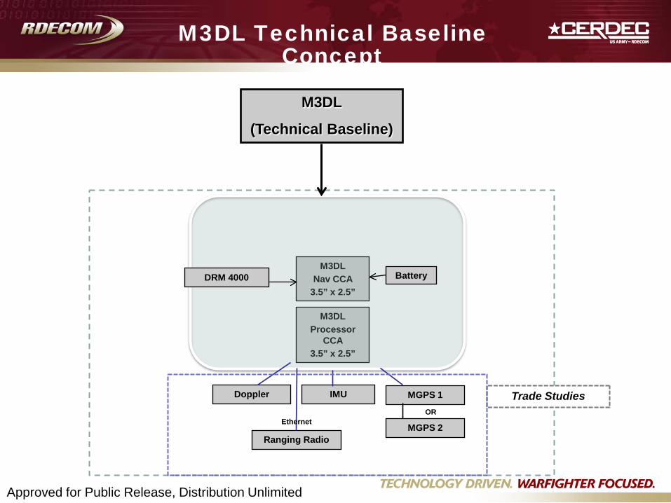
M3DL Technical Baseline Concept
M3DL
(Technical Baseline)
OR
Ranging Radio
IMUDoppler MGPS 1
MGPS 2
M3DLNav CCA
3.5” x 2.5”
M3DLProcessor
CCA3.5” x 2.5”
DRM 4000
Trade Studies
Battery
Ethernet
Approved for Public Release, Distribution Unlimited

Deliverables / Activities
•Deliverables– Monthly Reports– Operation Manual– Interface Design Description– 20 – M3DL Systems– Final Report
•Activities– Kick-off Meeting– Trades Studies– Technical Interchange Meeting– Final Demo
Approved for Public Release, Distribution Unlimited
RF Adaptive Technologies Integrated with Communications And Location (RADICAL)
Approved for Public Release, Distribution Unlimited

RF ADaptive Technologies Integrated with Communications And Location
(RADICAL)Purpose: Develop and demonstrate software that identifies
available spectrum dynamically (RF-aware) for tactical communications and for position location in GPS-degraded environments
Products:• Software module that enables spectrum policy
management for Dynamic Spectrum Access (DSA) enabled radios (e.g. PRC-148/152)
• Architecture to integrate and enhance DARPA Disruption Tolerant Networking (DTN) for future use in Army tactical networks such as WIN-T
• Software for position locating based on Net Assisted Navigation and RF Ranging techniques
Payoff:• Reliable message delivery in disruptive
communications environment• Provide position locating in GPS
degraded environments
08-01-08Approved for Public Release, Distribution Unlimited

RADICAL Navigation Technologies
Goal:
Develop RF based software modules for integration into soldiers’ radio systems.
- Capable of insertion with a wide variety of soldiers’ radio systems.
- Minimal impact to the hardware configuration of the communications or navigation equipment.
Activities:
- Soldier Navigation Architecture Study (SNAS)
- Network Assisted Navigation Software Development
- RF Ranging Software Development
- Test & Integration Approved for Public Release, Distribution Unlimited
RF Ranging
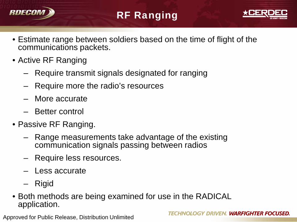
• Estimate range between soldiers based on the time of flight of the communications packets.
• Active RF Ranging – Require transmit signals designated for ranging – Require more the radio’s resources – More accurate – Better control
• Passive RF Ranging. – Range measurements take advantage of the existing
communication signals passing between radios – Require less resources. – Less accurate– Rigid
• Both methods are being examined for use in the RADICAL application.
Approved for Public Release, Distribution Unlimited

Network Assisted Navigation
• Improve the performance of GPS based navigation systems by providing data via the radio network to the GPS receiver.
• Using radio network to share position and measurement data between nodes to improve the overall position accuracy.
Approved for Public Release, Distribution Unlimited

FY 09 Soldier Navigation Architecture Study (SNAS)
Objective:
- Identify and rank candidate navigation architecture to support the transition of the RADICAL navigation technologies to fielded systems.
- Design a navigation architecture over the Platoon of dismounted Soldiers that satisfies the individual Soldier position performance needs while optimizing the navigation system attributes.
- Identify and address future position capabilities for the Soldier.
Approved for Public Release, Distribution Unlimited
Soldier Navigation Architecture Study Approach
• Perform Investigations – Identify dismounted Soldier navigation needs,
relevant navigation systems operational and physical characteristics, constraints as well as representative operational scenarios.
• Identified system attributes, (e.g., Cost, Power, Performance, Weight, Size, Robustness, …)
– Conduct Technology survey to identify candidate technologies
• Develop Trade Study Methodology – Set weights for system attributes– Establish System Performance Metrics
Approved for Public Release, Distribution Unlimited
Soldier Navigation Architecture Study
Approach (Cont.)• Candidate Architectures
– Develop candidate architectures
– Pare down candidate architectures and contributing technologies for analysis
• Conduct trade
– Include baseline architectures (i.g., current dismounted Soldier system)
– Baseline architectures with RADICAL technologies and other technologies
– Conduct simulation for performance evaluation
– Rank architectures
• Document Trade Study
Approved for Public Release, Distribution Unlimited

System Attributes
• Navigation Error• Cost• Power• Weight• Size• Integrity • Availability• Security• Complexity (Ease of Use)
•••
Attributes space
nRa∈
a1
a3
a4
Attribute 1 (e.g., Cost)
Attr
ibut
e 2
(e.g
., N
avig
atio
n Er
ror)
a2
Approved for Public Release, Distribution Unlimited
Weighting Attributes
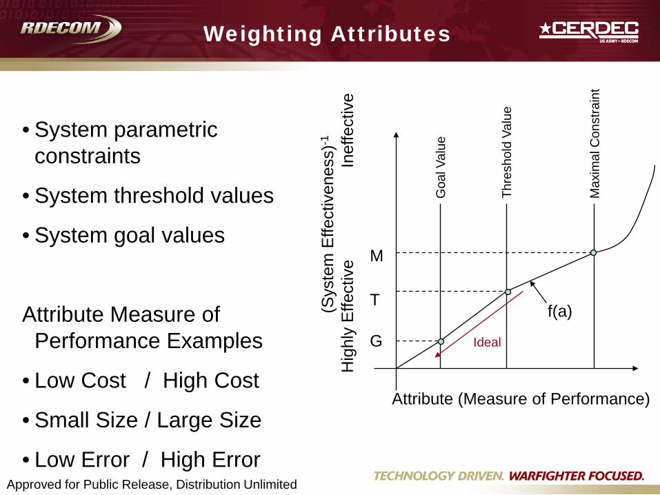
• System parametric constraints
• System threshold values
• System goal values
Attribute Measure of Performance Examples
• Low Cost / High Cost
• Small Size / Large Size
• Low Error / High Error
Max
imal
Con
stra
int
Thre
shol
d Va
lue
Goa
l Val
ue
G
T
M
f(a)(Sys
tem
Effe
ctiv
enes
s)-1
Hig
hly
Effe
ctiv
e
In
effe
ctiv
e
Attribute (Measure of Performance)
Ideal
Approved for Public Release, Distribution Unlimited
RADICAL Progress and Way Ahead
• Progress
– Met with users and Program Managers of fielded systems for technology transition
– Interviewed dismounted Soldiers on system attributes and operational scenarios
– Reviewed system specification and capability development document
• Next steps
– Interim Soldier Navigation Architecture Study Report
– Broad Agency Announcement (BAA) for RADICAL navigation technologies (Sept/Oct 2009)
Approved for Public Release, Distribution Unlimited